Embed Size (px)
Citation preview
Supporting Search and Rescue Operations withUAVs
Sonia Waharte and Niki TrigoniUniversity of Oxford
Computing LaboratoryOxford, United Kingdom
e-mail:sonia.waharte,[email protected]
Abstract— Search and rescue operations can greatly benefitfrom the use of autonomous UAVs to survey the environmentand collect evidence about the position of a missing person.To minimize the time to find the victim, some fundamentalparameters need to be accounted for in the design of the searchalgorithms: 1) quality of sensory data collected by the UAVs; 2)UAVs energy limitations; 3) environmental hazards (e.g. winds,trees); 4) level of information exchange/coordination betweenUAVs.
In this paper, we discuss how these parameters can affectthe search task and present some of the research avenues wehave been exploring. We then study the performance of differentsearch algorithms when the time to find the victim is theoptimization criterion.
I. INTRODUCTION
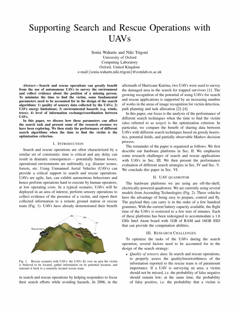
Search and rescue operations are often characterized by asimilar set of constraints: time is critical and any delay canresult in dramatic consequences – potentially human losses;operational environments are unfriendly, e.g. disaster scenes,forests, etc. Using Unmanned Aerial Vehicles (UAVs) canprovide a critical support to search and rescue operations.UAVs are agile, fast, can exhibit autonomous behaviours andhence perform operations hard to execute by human operators,at low operating costs. In a typical scenario, UAVs will bedeployed in an area of interest, perform sensory operations tocollect evidence of the presence of a victim, and report theircollected information to a remote ground station or rescueteam (Fig. 1). UAVs have already demonstrated their benefit
Fig. 1. Rescue scenario with UAVs: the UAVs fly over an area the victimis believed to be located, gather information on its potential location, andtransmit it back to a remotely located rescue team.
in search and rescue operations by helping responders to focustheir search efforts while avoiding hazards. In 2006, in the
aftermath of Hurricane Katrina, two UAVs were used to surveythe damaged area in the search for trapped survivors [1]. Thegrowing recognition of the potential of using UAVs for searchand rescue applications is supported by an increasing numberof works in the areas of image recognition for victim detection,path planning and task allocation [2]–[4].
In this paper, our focus is the analysis of the performance ofdifferent search techniques when the time to find the victim(also referred to as target) is the optimization criterion. Inparticular, we compare the benefit of sharing data betweenUAVs with different search techniques based on greedy heuris-tics, potential fields, and partially observable Markov decisionprocess.
The remainder of the paper is organized as follows. We firstdescribe our hardware platforms in Sec. II. We emphasizesome research challenges of search and rescue applicationswith UAVs in Sec. III. We then present the performanceevaluation of different search strategies in Sec. IV and Sec. V.We conclude this paper in Sec. VI.
II. UAV QUADROTOR
The hardware platforms we are using are off-the-shelf,electrically-powered quadrotors. We are currently using severalmodels from Ascending Technologies (Fig. 2). These vehicleshave the advantage of being easy to prepare, control and fly.The payload they can carry is in the order of a few hundredgrammes. With the current battery capacity available, the flighttime of the UAVs is restricted to a few tens of minutes. Eachof these platforms has been redesigned to accommodate a 1.6GHz Intel Atom board with 1GB of RAM and 16GB SSDthat can provide the computation abilities.
III. RESEARCH CHALLENGES
To optimize the tasks of the UAVs during the searchoperation, several factors need to be accounted for in thedesign of the search strategy:
• Quality of sensory data: In search and rescue operations,to properly assess the quality/trustworthiness of theinformation reported to the rescue team is of paramountimportance. If a UAV is surveying an area, a victimshould not be missed, i.e. the probability of false negativeshould remain low; at the same time, the probabilityof false positive, i.e. the probability that a victim is
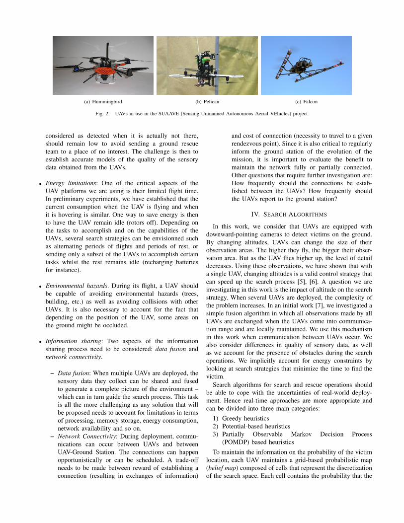
(a) Hummingbird (b) Pelican (c) Falcon
Fig. 2. UAVs in use in the SUAAVE (Sensing Unmanned Autonomous Aerial VEhicles) project.
considered as detected when it is actually not there,should remain low to avoid sending a ground rescueteam to a place of no interest. The challenge is then toestablish accurate models of the quality of the sensorydata obtained from the UAVs.
• Energy limitations: One of the critical aspects of theUAV platforms we are using is their limited flight time.In preliminary experiments, we have established that thecurrent consumption when the UAV is flying and whenit is hovering is similar. One way to save energy is thento have the UAV remain idle (rotors off). Depending onthe tasks to accomplish and on the capabilities of theUAVs, several search strategies can be envisionned suchas alternating periods of flights and periods of rest, orsending only a subset of the UAVs to accomplish certaintasks whilst the rest remains idle (recharging batteriesfor instance).
• Environmental hazards. During its flight, a UAV shouldbe capable of avoiding environmental hazards (trees,building, etc.) as well as avoiding collisions with otherUAVs. It is also necessary to account for the fact thatdepending on the position of the UAV, some areas onthe ground might be occluded.
• Information sharing: Two aspects of the informationsharing process need to be considered: data fusion andnetwork connectivity.
– Data fusion: When multiple UAVs are deployed, thesensory data they collect can be shared and fusedto generate a complete picture of the environment –which can in turn guide the search process. This taskis all the more challenging as any solution that willbe proposed needs to account for limitations in termsof processing, memory storage, energy consumption,network availability and so on.
– Network Connectivity: During deployment, commu-nications can occur between UAVs and betweenUAV-Ground Station. The connections can happenopportunistically or can be scheduled. A trade-offneeds to be made between reward of establishing aconnection (resulting in exchanges of information)
and cost of connection (necessity to travel to a givenrendezvous point). Since it is also critical to regularlyinform the ground station of the evolution of themission, it is important to evaluate the benefit tomaintain the network fully or partially connected.Other questions that require further investigation are:How frequently should the connections be estab-lished between the UAVs? How frequently shouldthe UAVs report to the ground station?
IV. SEARCH ALGORITHMS
In this work, we consider that UAVs are equipped withdownward-pointing cameras to detect victims on the ground.By changing altitudes, UAVs can change the size of theirobservation areas. The higher they fly, the bigger their obser-vation area. But as the UAV flies higher up, the level of detaildecreases. Using these observations, we have shown that witha single UAV, changing altitudes is a valid control strategy thatcan speed up the search process [5], [6]. A question we areinvestigating in this work is the impact of altitude on the searchstrategy. When several UAVs are deployed, the complexity ofthe problem increases. In an initial work [7], we investigated asimple fusion algorithm in which all observations made by allUAVs are exchanged when the UAVs come into communica-tion range and are locally maintained. We use this mechanismin this work when communication between UAVs occur. Wealso consider differences in quality of sensory data, as wellas we account for the presence of obstacles during the searchoperations. We implicitly account for energy constraints bylooking at search strategies that minimize the time to find thevictim.
Search algorithms for search and rescue operations shouldbe able to cope with the uncertainties of real-world deploy-ment. Hence real-time approaches are more appropriate andcan be divided into three main categories:
1) Greedy heuristics2) Potential-based heuristics3) Partially Observable Markov Decision Process
(POMDP) based heuristicsTo maintain the information on the probability of the victim
location, each UAV maintains a grid-based probabilistic map(belief map) composed of cells that represent the discretizationof the search space. Each cell contains the probability that the
target is present in it. These maps are commonly used for ap-plications such as surface mapping, exploration or navigation(e.g. [8]).
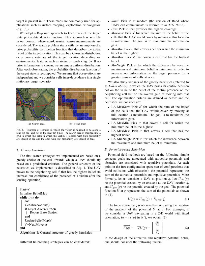
We adopt a Bayesian approach to keep track of the targetstate probability density function. This approach is sensiblein our context, where non-Gaussian sensor measurements areconsidered. The search problem starts with the assumption of aprior probability distribution function that describes the initialbelief of the target location. This can be a Gaussian distributionor a coarse estimate of the target location depending onenvironmental features such as rivers or roads (Fig. 3). If noprior information is known, we assume a uniform distribution.After each observation, the probability distribution function ofthe target state is recomputed. We assume that observations areindependent and we consider cells inter-dependence in a singlestationary target scenario.
(a) Search area (b) Belief map
Fig. 3. Example of scenario in which the victim is believed to be along aroad (in red) and not in the river (in blue). The search area is mapped into agrid in which the cells in which the victim is located with high probabilityare shaded in red and the ones with low probability are shaded in blue.
A. Greedy heuristics
The first search strategies we implemented are based on agreedy choice of the cell towards which a UAV should flybased on a predefined criterion. The general structure of theheuristics we implemented is described in Alg. 1. The UAVmoves to the neighboring cell s that has the highest belief (toincrease our confidence of the presence of a victim after thesensing operation).
Start=s’Initialize BeliefMapwhile true do
s=s’GetObservation(s)if target detected then
Report Base StationendUpdateBeliefMap(s)s’=NextMove(s)
endAlgorithm 1: General structure of greedy heuristics
Different tie-breaking strategies can be considered:
• Rand: Pick s at random (the version of Rand whereUAVs can communicate is referred to as MS Rand).
• Cov: Pick s that provides the highest coverage.• MaxSum: Pick s for which the sum of the belief of the
cells that the UAV would cover by moving at this locationis maximum. The goal is to maximize the informationgain.
• MaxMin: Pick s that covers a cell for which the minimumbelief is the highest.
• MaxMax: Pick s that covers a cell that has the highestbelief.
• MinNeigh: Pick s for which the difference between themaximum and minimum belief is minimum in order toincrease our information on the target presence for agreater number of cells at once.
We also study variants of the greedy heuristics (referred toas 1-look ahead) in which the UAV bases its control decisionnot on the value of the belief of the victim presence on theneighboring cell but on the overall gain of moving into thatcell. The optimization criteria are defined as before and theheuristics we consider are:
• LA MaxSum: Pick s for which the sum of the beliefof the cells that the UAV would cover by moving atthis location is maximum. The goal is to maximize theinformation gain.
• LA MaxMin: Pick s that covers a cell for which theminimum belief is the highest.
• LA MaxMax: Pick s that covers a cell that has thehighest belief.
• LA MinNeigh: Pick s for which the difference betweenthe maximum and minimum belief is minimum.
B. Potential-based AlgorithmPotential field methods are based on the following simple
concept: goals are associated with attractive potentials andobstacles are associated with repulsive potentials. At eachpoint in the free configuration space (set of configurations thatavoid collisions with obstacles), the potential represents thesum of the attractive potentials and repulsive potentials. Moreformally, let us consider a UAV at position q. Let Uobs(q)be the potential created by an obstacle at the UAV location q,and Ugoal(q) be the potential created by the goal. The potentialfunction U at q represents the sum of the potentials as shownin (1).
U(q) = Uobs(q) + Ugoal(q) (1)
The force exerted at q is obtained by computing the negativeof the gradient of the potential U at q. For example, ifwe consider a UAV navigating in a 2-D world with fixedorientation, (q = (x, y) in 2), we obtain (2):
−−→F (q) = −∇U(q) =
∂U∂x
∂U∂y
(2)
In the design of the attractive and repulsive potential fields,one should consider the following factors:
• Attractive potentials should increase as the UAV movesaway from the goal. When the UAV reaches the goal, noforces from the goal should act upon it.
• Repulsive potentials should increase as the UAV comescloser to an obstacle. But repulsive potentials should notaffect the UAV motion when it is far from the obstacle.
Practically, in our search and rescue scenario, we assignedto each cell a weight that depends on its nature: obstaclesand already-visited locations. The weight of each cellthat is visited is increased by Kv after each visit. Apotential is computed for each grid cell according to Alg. 2.
InitializationFor each cell that is an obstacle, assign maxWeights = start location
while true doassign weight w(s) = min(w(s) + Kv, maxWeight)for each cell do
compute distance dv to visited cellsU(cell) = w(cell)/d2
vends’=neighboring cell with minimum potentialmove UAV to location s’if target in s’ then
Report Base Stationends = s’
endAlgorithm 2: Potential-based search algorithm
C. Partially Observable Markov Decision Process
Partially Observable Markov Decision Processes (POMDPs)are a generalisation of a Markov Decision Process (MDP) tosituations where the system can be modelled by a MDP, butthe underlying states are unobservable. Instead, the state dis-tribution must be inferred based on a model of the world andlocal observations where, typically, sensors provide partial andnoisy information about the world. The POMDP frameworkis general enough to model a variety of real-world sequentialdecision processes. An exact solution to a POMDP yields theoptimal action for each possible belief over the world states.The optimal action maximizes (or minimizes) the expectedreward (or cost) of the agent over a time horizon. The sequenceof optimal actions is known as the optimal policy and is chosenso as to optimise the expected reward (or cost).
Formally, a POMDP is represented by the following n-tuple:S, A,O, b0, T.Ω, R, γ, with:
• S: finite set of discrete states,• A: set of actions,• O: set of observations,• b0: initial belief states distribution,• T (s, a, s): probability of transition from s to s when
taking action a,• Ω(o, s, a): probability of observing o from state s after
taking action a,• R(s, a): reward when executing action a in state s,
!"#$%&'(#%)*+#,-"*(
.)*/(01%&'(#
23!1'-14#5#&16
7
489:
48;:
48<:
;9
<
23!1'-14#5#&1=
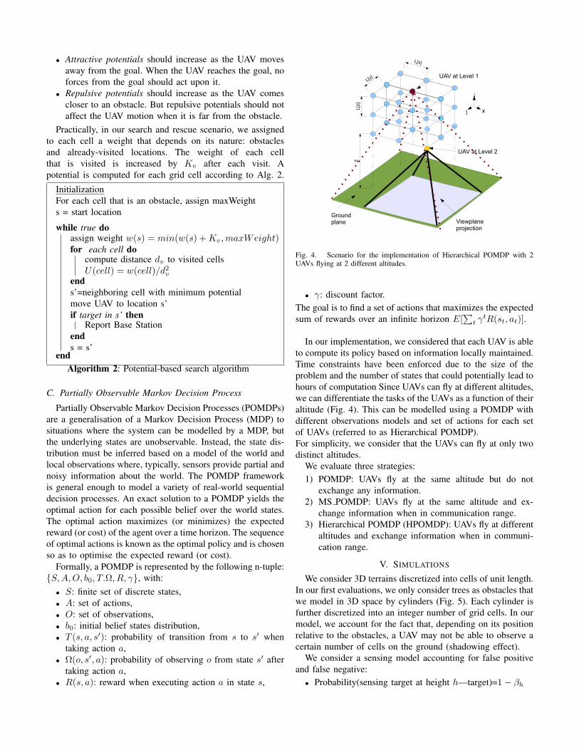
Fig. 4. Scenario for the implementation of Hierarchical POMDP with 2UAVs flying at 2 different altitudes.
• γ: discount factor.The goal is to find a set of actions that maximizes the expectedsum of rewards over an infinite horizon E[
t γtR(st, at)].
In our implementation, we considered that each UAV is ableto compute its policy based on information locally maintained.Time constraints have been enforced due to the size of theproblem and the number of states that could potentially lead tohours of computation Since UAVs can fly at different altitudes,we can differentiate the tasks of the UAVs as a function of theiraltitude (Fig. 4). This can be modelled using a POMDP withdifferent observations models and set of actions for each setof UAVs (referred to as Hierarchical POMDP).For simplicity, we consider that the UAVs can fly at only twodistinct altitudes.
We evaluate three strategies:1) POMDP: UAVs fly at the same altitude but do not
exchange any information.2) MS POMDP: UAVs fly at the same altitude and ex-
change information when in communication range.3) Hierarchical POMDP (HPOMDP): UAVs fly at different
altitudes and exchange information when in communi-cation range.
V. SIMULATIONS
We consider 3D terrains discretized into cells of unit length.In our first evaluations, we only consider trees as obstacles thatwe model in 3D space by cylinders (Fig. 5). Each cylinder isfurther discretized into an integer number of grid cells. In ourmodel, we account for the fact that, depending on its positionrelative to the obstacles, a UAV may not be able to observe acertain number of cells on the ground (shadowing effect).
We consider a sensing model accounting for false positiveand false negative:
• Probability(sensing target at height h—target)=1− βh
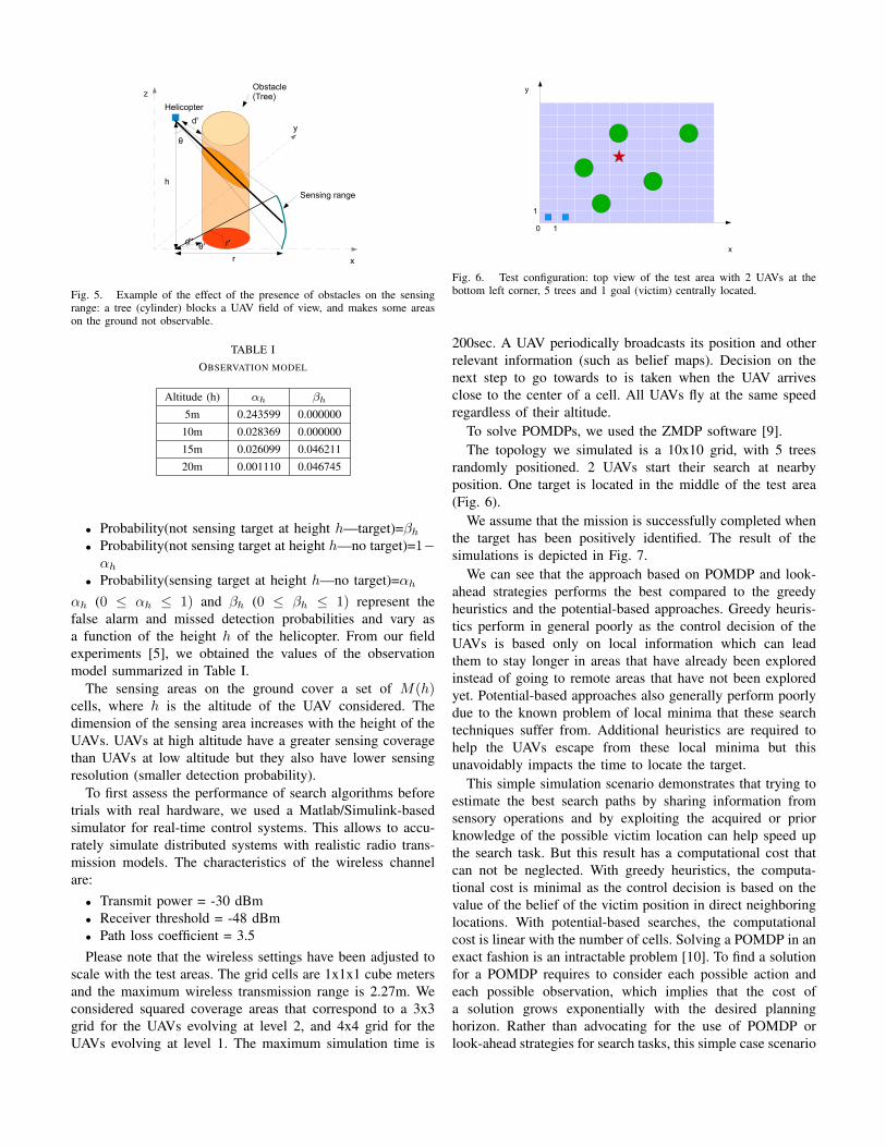
Fig. 5. Example of the effect of the presence of obstacles on the sensingrange: a tree (cylinder) blocks a UAV field of view, and makes some areason the ground not observable.
TABLE IOBSERVATION MODEL
Altitude (h) αh βh
5m 0.243599 0.00000010m 0.028369 0.00000015m 0.026099 0.04621120m 0.001110 0.046745
• Probability(not sensing target at height h—target)=βh
• Probability(not sensing target at height h—no target)=1−αh
• Probability(sensing target at height h—no target)=αh
αh (0 ≤ αh ≤ 1) and βh (0 ≤ βh ≤ 1) represent thefalse alarm and missed detection probabilities and vary asa function of the height h of the helicopter. From our fieldexperiments [5], we obtained the values of the observationmodel summarized in Table I.
The sensing areas on the ground cover a set of M(h)cells, where h is the altitude of the UAV considered. Thedimension of the sensing area increases with the height of theUAVs. UAVs at high altitude have a greater sensing coveragethan UAVs at low altitude but they also have lower sensingresolution (smaller detection probability).
To first assess the performance of search algorithms beforetrials with real hardware, we used a Matlab/Simulink-basedsimulator for real-time control systems. This allows to accu-rately simulate distributed systems with realistic radio trans-mission models. The characteristics of the wireless channelare:
• Transmit power = -30 dBm• Receiver threshold = -48 dBm• Path loss coefficient = 3.5Please note that the wireless settings have been adjusted to
scale with the test areas. The grid cells are 1x1x1 cube metersand the maximum wireless transmission range is 2.27m. Weconsidered squared coverage areas that correspond to a 3x3grid for the UAVs evolving at level 2, and 4x4 grid for theUAVs evolving at level 1. The maximum simulation time is
!
"
#
#$
!"#$%#&"'()*+%,%&'&()*+&,&-&./00+&1&#&.2/30.&
Fig. 6. Test configuration: top view of the test area with 2 UAVs at thebottom left corner, 5 trees and 1 goal (victim) centrally located.
200sec. A UAV periodically broadcasts its position and otherrelevant information (such as belief maps). Decision on thenext step to go towards to is taken when the UAV arrivesclose to the center of a cell. All UAVs fly at the same speedregardless of their altitude.
To solve POMDPs, we used the ZMDP software [9].The topology we simulated is a 10x10 grid, with 5 trees
randomly positioned. 2 UAVs start their search at nearbyposition. One target is located in the middle of the test area(Fig. 6).
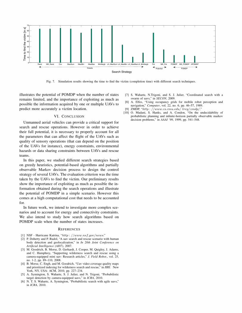
We assume that the mission is successfully completed whenthe target has been positively identified. The result of thesimulations is depicted in Fig. 7.
We can see that the approach based on POMDP and look-ahead strategies performs the best compared to the greedyheuristics and the potential-based approaches. Greedy heuris-tics perform in general poorly as the control decision of theUAVs is based only on local information which can leadthem to stay longer in areas that have already been exploredinstead of going to remote areas that have not been exploredyet. Potential-based approaches also generally perform poorlydue to the known problem of local minima that these searchtechniques suffer from. Additional heuristics are required tohelp the UAVs escape from these local minima but thisunavoidably impacts the time to locate the target.
This simple simulation scenario demonstrates that trying toestimate the best search paths by sharing information fromsensory operations and by exploiting the acquired or priorknowledge of the possible victim location can help speed upthe search task. But this result has a computational cost thatcan not be neglected. With greedy heuristics, the computa-tional cost is minimal as the control decision is based on thevalue of the belief of the victim position in direct neighboringlocations. With potential-based searches, the computationalcost is linear with the number of cells. Solving a POMDP in anexact fashion is an intractable problem [10]. To find a solutionfor a POMDP requires to consider each possible action andeach possible observation, which implies that the cost ofa solution grows exponentially with the desired planninghorizon. Rather than advocating for the use of POMDP orlook-ahead strategies for search tasks, this simple case scenario
Rand MS_Rand Cov MaxSum MaxMin MaxMax MinNeigh LA_MaxSum LA_MaxMin LA_MaxMax LA_MinNeigh Pot MS_Pot POMDP MS_POMDP HPOMDP0
10
20
30
40
50
60
70Ti
me
to fi
nd th
e vic
tim [i
n s]
Search StrategyPOMDPGreedy Potential
Fig. 7. Simulation results showing the time to find the victim (completion time) with different search techniques.
illustrates the potential of POMDP when the number of statesremains limited, and the importance of exploiting as much aspossible the information acquired by one or multiple UAVs topredict more accurately a victim location.
VI. CONCLUSION
Unmanned aerial vehicles can provide a critical support forsearch and rescue operations. However in order to achievetheir full potential, it is necessary to properly account for allthe parameters that can affect the flight of the UAVs such asquality of sensory operations (that can depend on the positionof the UAVs for instance), energy constraints, environmentalhazards or data sharing constraints between UAVs and rescueteams.
In this paper, we studied different search strategies basedon greedy heuristics, potential-based algorithms and partiallyobservable Markov decision process to design the controlstrategy of several UAVs. The evaluation criterion was the timetaken by the UAVs to find the victim. Our preliminary resultsshow the importance of exploiting as much as possible the in-formation obtained during the search operations and illustratethe potential of POMDP in a simple scenario. However thiscomes at a high computational cost that needs to be accountedfor.
In future work, we intend to investigate more complex sce-narios and to account for energy and connectivity constraints.We also intend to study how search algorithms based onPOMDP scale when the number of states increases.
REFERENCES
[1] NSF - Hurricane Katrina, “http : //www.nsf.gov/news.”[2] P. Doherty and P. Rudol, “A uav search and rescue scenario with human
body detection and geolocalization,” in In 20th Joint Conference onArtificial Intelligence (AI07), 2007.
[3] M. Goodrich, B. Morse, D. Gerhardt, J. Cooper, M. Quigley, J. Adams,and C. Humphrey, “Supporting wilderness search and rescue using acamera-equipped mini uav: Research articles,” J. Field Robot., vol. 25,no. 1-2, pp. 89–110, 2008.
[4] B. Morse, C. Engh, and M. Goodrich, “Uav video coverage quality mapsand prioritized indexing for wilderness search and rescue,” in HRI. NewYork, NY, USA: ACM, 2010, pp. 227–234.
[5] A. Symington, S. Waharte, S. J. Julier, and N. Trigoni, “Probabilistictarget detection by camera-equipped uavs,” in ICRA, 2010.
[6] N. T. S. Waharte, A. Symington, “Probabilistic search with agile uavs,”in ICRA, 2010.
[7] S. Waharte, N.Trigoni, and S. J. Julier, “Coordinated search with aswarm of uavs,” in SECON, 2009.
[8] A. Elfes, “Using occupancy grids for mobile robot perception andnavigation,” Computer, vol. 22, no. 6, pp. 46–57, 1989.
[9] ZMDP, “http : //www.cs.cmu.edu/ trey/zmdp/.”[10] O. Madani, S. Hanks, and A. Condon, “On the undecidability of
probabilistic planning and infinite-horizon partially observable markovdecision problems,” in AAAI ’99, 1999, pp. 541–548.