Embed Size (px)
Citation preview
SUNKEN ROMAN VILLA OF ANCIENT EPIDAURUS: DOCUMENTATION AND ENHANCEMENT USING VIRTUAL REALITY
M. Skamantzari 1, A. Georgopoulos 1, C. Palyvou 2
1 National Technical University of Athens, School of Rural and Survey Engineering, Lab of Photogrammetry
Zografou Campus, Heroon Polytechniou 9, 15780, Zografou, Athens, Greece - (mskamantz, drag)@central.ntua.gr 2 Aristotle University of Thessaloniki, School of Architecture University Campus, 54124, Thessaloniki, Greece -
Commission II, WG II/8
KEY WORDS: Geometric Documentation, Underwater Cultural Heritage, 3D Modelling, SfM/MVS, Virtual Reality ABSTRACT: The interest in the documentation and enhancement of Underwater Cultural Heritage (UCH) is rising rapidly over the last decades. This has happened especially due to the significant technological advances, which have enabled the digital data acquisition in the hostile underwater environment. Numerous efforts have been made so far concerning the 3D digitisation and promotion of the UCH using photogrammetric methods and 3D surveys in order on one hand to document the site and on the other to develop virtual and augmented reality applications and make this part of the hidden cultural heritage accessible to people with difficulties to reach it. This paper presents the methodology, the actions and decisions that were taken for the geometric documentation, study, promotion and enhancement of the remains of a roman villa located at Agios Vlassis, in Ancient Epidaurus in Greece. The present effort focuses on the use of low-cost equipment in order to acquire the necessary digital data to produce the 3D textured model of the archaeological site and the required 2D documentation products. The methods used to produce this 3D model involve contemporary computer vision algorithms adapted to confront the challenge of processing a huge number of images and extracting useful metric information from them. Moreover, the creation and programming process of two virtual reality applications is described. By developing a virtual tour and a virtual reality application, it is hoped to raise the awareness about UCH and give prominence to different means and ways of protection and management of underwater archaeological sites.
1. THE SUNKEN ROMAN VILLA IN EPIDAURUS
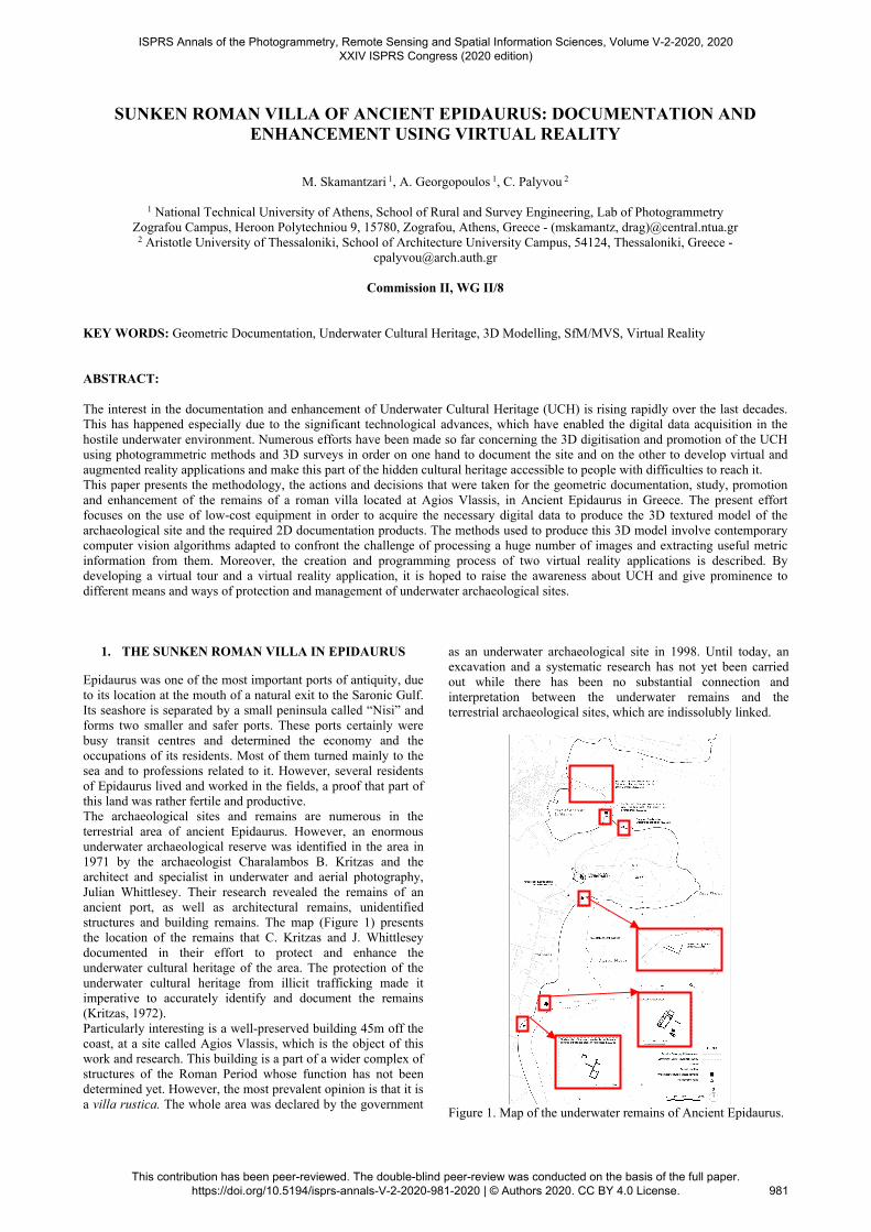
Epidaurus was one of the most important ports of antiquity, due to its location at the mouth of a natural exit to the Saronic Gulf. Its seashore is separated by a small peninsula called “Nisi” and forms two smaller and safer ports. These ports certainly were busy transit centres and determined the economy and the occupations of its residents. Most of them turned mainly to the sea and to professions related to it. However, several residents of Epidaurus lived and worked in the fields, a proof that part of this land was rather fertile and productive. The archaeological sites and remains are numerous in the terrestrial area of ancient Epidaurus. However, an enormous underwater archaeological reserve was identified in the area in 1971 by the archaeologist Charalambos B. Kritzas and the architect and specialist in underwater and aerial photography, Julian Whittlesey. Their research revealed the remains of an ancient port, as well as architectural remains, unidentified structures and building remains. The map (Figure 1) presents the location of the remains that C. Kritzas and J. Whittlesey documented in their effort to protect and enhance the underwater cultural heritage of the area. The protection of the underwater cultural heritage from illicit trafficking made it imperative to accurately identify and document the remains (Kritzas, 1972). Particularly interesting is a well-preserved building 45m off the coast, at a site called Agios Vlassis, which is the object of this work and research. This building is a part of a wider complex of structures of the Roman Period whose function has not been determined yet. However, the most prevalent opinion is that it is a villa rustica. The whole area was declared by the government
as an underwater archaeological site in 1998. Until today, an excavation and a systematic research has not yet been carried out while there has been no substantial connection and interpretation between the underwater remains and the terrestrial archaeological sites, which are indissolubly linked.
Figure 1. Map of the underwater remains of Ancient Epidaurus.
ISPRS Annals of the Photogrammetry, Remote Sensing and Spatial Information Sciences, Volume V-2-2020, 2020 XXIV ISPRS Congress (2020 edition)
This contribution has been peer-reviewed. The double-blind peer-review was conducted on the basis of the full paper. https://doi.org/10.5194/isprs-annals-V-2-2020-981-2020 | © Authors 2020. CC BY 4.0 License.
981
The seashore and consequently the underwater remains are accessible to the public without any control or restrictions from any official authority. Especially during the summer, the visitors arrive to the area just to take a closer look at the so-called “Sunken City” and the underwater remains. Due to this fact, the underwater remains of Ancient Epidaurus are in great danger, as the human factor can be rather harmful when the visits to the underwater archaeological sites are unattended and without the proper guidance. In the Peloponnese and in the area of Epidaurus in particular, a rather intriguing field of research is the morphology, the shifting and the changes of the coastline. Studies that deal with the changes of coastal areas link this phenomenon to submerged archaeological sites and try to survey the coastal mobility (Avramea, 2012). The list of the submerged cities of the Peloponnese, which was written by N. Flemming and completed by Pirazzoli, includes 21 different sites, the type of the ruins found at each one, the level of sinking and any previous bibliography about them. In fact, Flemming mentions that the area of Epidaurus was most likely sunken by 2.7m. (Flemming et al., 1971). Moreover, the number of sunken sites on the southern shores of Peloponnese creates a great impression, many of which date back to the Roman Period. Unfortunately, the researchers and experts who tried to find out when these sunken cities were abandoned in each case, are very few. Most of them focus their attention and research on the period of their great acme. Apart from the geomorphological and tectonic phenomena caused by earthquakes, erosion is another factor that contributes to the alteration of the coastline. Another phenomenon is the high frequency of river terraces in the Mediterranean, a phenomenon that was generalised during the long period between 400 and 900 A.D. 1.1 Historic Documentation and Typology of Roman Villas
The villa is a building that can be found not only within the narrow borders of a city, but also in the wider urban limits and outside the city. The ones located outside the city borders are specifically the villas rustica. The term villa in general refers to a house whose main feature is the isolation of the residents from the rest of the city (Ginouvès, 1998). According to the literature there are many different types of villa and as a result an informal and sometimes incorrect typology has been developed. The main types of villa are the villa urbana, the villa rustica and the villa maritima. The Roman writers mainly mention two types of villa, the villa urbana and the villa rustica. The term of villa urbana is used for residencies in the city or in the suburbs of it, while the term of villa rustica refers to farmhouses. However, there are cases where the two different types are connected and transform the property into a single complex of structures where the production processes take place in the villa rustica. Finally, the last type of villa is the one of villa maritima. All the villas built near the coastline appertain to the category of villa maritima. In order to better understand the structure and the facilities of a roman villa, it is important to study and make a further research into the typology of roman villas in general. It is worth mentioning the main parts of a villa and their function. First of all, each villa had a single main entrance that communicated with the street and was the point of transition from the outside to the interior of the villa. In some cases, a villa had more than one entrances, but still there was one main entrance (Said, 2002). The visitor, after entering the villa, found himself in an anteroom, a transitional area where sometimes there was a staircase to the upper floor of the villa or the roof. In addition, some villas hosted shops, which were architecturally integrated into the structure, while at the same time they operated
independently. The shops were either owned and used by the residents of the villa, in which case they communicated directly with the villa, or otherwise they were rented by others. When moving to the interior of the villa, the visitor finds the peristyle, which is the “heart” of every rich residence of the Roman period. The peristyle usually consists of a three or four side colonnade and is accessible from the anteroom, while a number of rooms are lined up around it. Furthermore, the room that welcomed the visitors and was used for the purpose of dining, the triclinium, was found at one of the peristyle’s side. In the villas of late antiquity in Greece two types of triclinium were identified, the arched one and the rectangular one. Although the dimensions of the triclinium differ from one villa to another, in most of them the diameter of the apse is approximately 6m and can host about 7 people. In Greece, the dated and documented examples of the arched triclinium belong mainly to the 4th and 5th century A.D. Another important part of the Roman villa are the baths. Roman baths in a domestic environment were usually designed to accommodate more than one persons and were used for social purposes, such as welcoming guests or expanding gatherings. The bedrooms were located in the most private part of the villa and can be identified by the frequent placement of the bed on a slightly raised floor comparing to the rest of the room and by the use of different decorative designs on the floor, usually mosaics. Furthermore, the roman villa was not lacking sanitation facilities, kitchen and various auxiliary rooms such as storages, galleries, bakeries, stables. It is also important and interesting to study the location and size of the roman villas. A first categorisation of wealthy villas can be made according to their scale. As a result, there are medium sized villas of 350-500m2, large sized of about 500-1000m2 and very large villas of 1000-1500m2. Regarding the location, the rich preferred to have villas next to the coast (villa maritima) during the period of late antiquity in Greece. The location of the villa significantly affected its size and typology, since the rich people were looking for more space and tended to build their villas in the outskirts of the towns. Examples of villas presenting some similarities with the sunken roman villa of Ancient Epidaurus can be found in Akra Sofia and Kegxrees, Corinthos, Ostia, Ancient Epidaurus, Asina, Alieis and Piraeus. Most of them are villas maritima or villas rustica. A characteristic example of villa maritima can be found at Fourkari in the city of Troizinia. The complex that covers about 120m of the ancient coastline is now submerged and was dated in the 5th or 6th century A.D. (Said, 2002). Another interesting case is the one of Alieis in Ermioni, where a complex of six structures was found under the water. This complex must have been located between the coast and the main road to Ermioni and probably was a villa rustica of the late roman period. There is also an archaeological site on dry land next to the underwater remains, forming a cohesive, undivided archaeological site. In northern Greece, there are also buildings and complexes of structures that have been identified as villas in Dioclitianoupolis of Kastoria and Philippi. However, there are many examples of Roman villas outside the geographic borders of Greece like the one in Ancient Epidaurus. One of the best-preserved examples of Campanian villa rustica was revealed near Boscoreale in 1893-94, two miles north of Pompeii (McKay, 1975). The villa has an industrial character due to its spacious storage room and dates to 27 B.C. Another example of a villa with a strong and distinct productive character is the House of the Frescoes in Tampa of Algeria (Ellis, 2000). Furthermore, at the port of Cavalaire in France, the French-Roman villa Pardigon is located near the sea, occupying an area of 2000m2 (Timár, 2011). This is a very large villa with at least 28 rooms. Finally, Domus della Fortuna
ISPRS Annals of the Photogrammetry, Remote Sensing and Spatial Information Sciences, Volume V-2-2020, 2020 XXIV ISPRS Congress (2020 edition)
This contribution has been peer-reviewed. The double-blind peer-review was conducted on the basis of the full paper. https://doi.org/10.5194/isprs-annals-V-2-2020-981-2020 | © Authors 2020. CC BY 4.0 License.
982
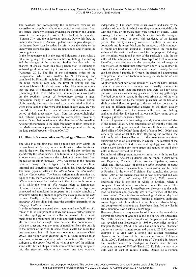
Annonaria is a well-preserved villa of the 2nd century A.D. in the ancient city of Ostia. It is a typical example of a private residence of the imperial period, which however presents some differences in typology compared to the villas of the early imperial period. The building has a long history and there are many different construction phases, clearly distinguishable. According to the above information and based on the detailed geometric documentation of the underwater remains of Ancient Epidaurus, it was possible to make some observations concerning the historical documentation and to identify construction phases, as well as specific parts and facilities of the villa. Since no excavations and further research have been carried out in the area, it is not possible to come to conclusions, but it is worthwhile to make some hypotheses based on the evidence and the literature. Initially, it should be noted that this villa belongs to the type of villa maritima, due to its location near the coast in the late roman times. It is also obvious that some of the functions of the villa are related to productive and agricultural processes. Moreover, the three-dimensional model of the remains made it possible to identify unconnected walls, different building materials and traces on the remains, indications of different construction phases that require further research. Also, the main functional areas of the Roman villa were recognised, such as the arched triclinium, which could host 6 people, and the main storage area of the villa, where there is a number of storage jars (Figure 2).
Figure 2. The typology of the sunken roman villa (2D drawing).
2. GEOMETRIC DOCUMENTATION
The first step in the process of the geometric documentation is the reconnaissance and understanding of the remains and the surrounding area. At this stage, the peculiarities of the area, the underwater remains of the roman villa and the hostile underwater environment need to be taken under serious consideration in order to recognise the difficulties that could arise during the process and make a proper planning of the work (Georgopoulos, Agrafiotis, 2012). In this way, the best possible result will be achieved, considering the factors of time and of available equipment for this specific case study. The next step is the scheduling of the tasks required for the geometric documentation of the underwater remains of the roman villa in Ancient Epidaurus. This workflow mostly concerns the tasks and work necessary to be done in situ at the archaeological site. There is a number of significant factors that affect the decisions and choices which were made. These factors are the final products of the documentation, the accuracy, the available means and equipment, the required time and the cost of the overall process. In particular, considerations were made concerning the method that was chosen, the type of measurements, the estimated time, the premarked targets used, as well as the necessary diving, geodetic and photogrammetric
equipment required for the underwater documentation of the roman villa. The next steps were the data acquisition, their processing and the production of the three-dimensional model. Especially for the underwater cultural heritage, the production of a detailed and accurate 3D model is a rather important and useful process since it enables the documentation of the remains found in a hostile environment and at the same time it documents the site and makes this part of the hidden cultural heritage accessible to everyone (Menna et al., 2018). 2.1 Data Acquisition
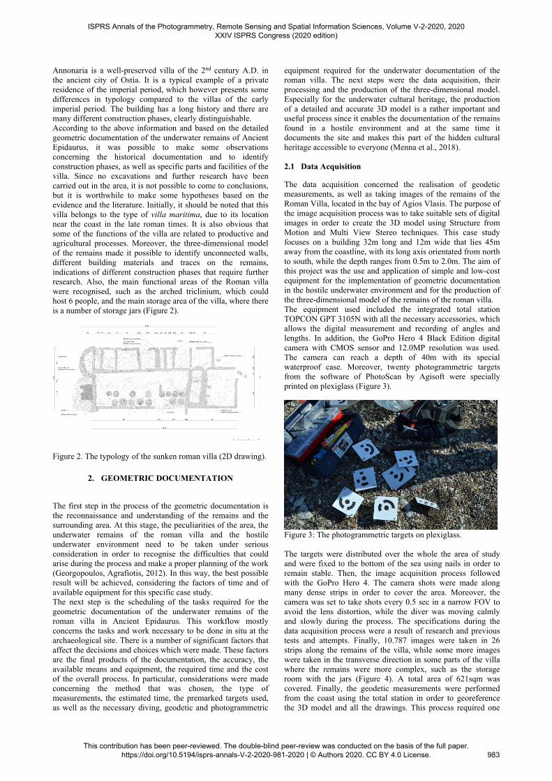
The data acquisition concerned the realisation of geodetic measurements, as well as taking images of the remains of the Roman Villa, located in the bay of Agios Vlasis. The purpose of the image acquisition process was to take suitable sets of digital images in order to create the 3D model using Structure from Motion and Multi View Stereo techniques. This case study focuses on a building 32m long and 12m wide that lies 45m away from the coastline, with its long axis orientated from north to south, while the depth ranges from 0.5m to 2.0m. The aim of this project was the use and application of simple and low-cost equipment for the implementation of geometric documentation in the hostile underwater environment and for the production of the three-dimensional model of the remains of the roman villa. The equipment used included the integrated total station TOPCON GPT 3105N with all the necessary accessories, which allows the digital measurement and recording of angles and lengths. In addition, the GoPro Hero 4 Black Edition digital camera with CMOS sensor and 12.0MP resolution was used. The camera can reach a depth of 40m with its special waterproof case. Moreover, twenty photogrammetric targets from the software of PhotoScan by Agisoft were specially printed on plexiglass (Figure 3).
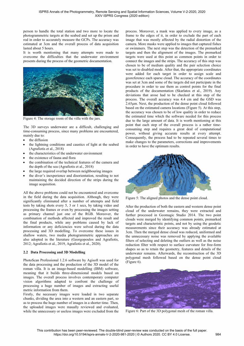
Figure 3: The photogrammetric targets on plexiglass. The targets were distributed over the whole the area of study and were fixed to the bottom of the sea using nails in order to remain stable. Then, the image acquisition process followed with the GoPro Hero 4. The camera shots were made along many dense strips in order to cover the area. Moreover, the camera was set to take shots every 0.5 sec in a narrow FOV to avoid the lens distortion, while the diver was moving calmly and slowly during the process. The specifications during the data acquisition process were a result of research and previous tests and attempts. Finally, 10.787 images were taken in 26 strips along the remains of the villa, while some more images were taken in the transverse direction in some parts of the villa where the remains were more complex, such as the storage room with the jars (Figure 4). A total area of 621sqm was covered. Finally, the geodetic measurements were performed from the coast using the total station in order to georeference the 3D model and all the drawings. This process required one
ISPRS Annals of the Photogrammetry, Remote Sensing and Spatial Information Sciences, Volume V-2-2020, 2020 XXIV ISPRS Congress (2020 edition)
This contribution has been peer-reviewed. The double-blind peer-review was conducted on the basis of the full paper. https://doi.org/10.5194/isprs-annals-V-2-2020-981-2020 | © Authors 2020. CC BY 4.0 License.
983
person to handle the total station and two more to locate the photogrammetric targets at the seabed and set up the prism and rod in order to accurately measure the GCPs. The accuracy was estimated at 3cm and the overall process of data acquisition lasted about 5 hours. It is worth mentioning that many attempts were made to overcome the difficulties that the underwater environment presents during the process of the geometric documentation.
Figure 4: The storage room of the villa with the jars. The 3D surveys underwater are a difficult, challenging and time-consuming process, since many problems are encountered, mainly due to: the diffusion the lightning conditions and caustics of light at the seabed
(Agrafiotis et al., 2018) the characteristics of the underwater environment the existence of fauna and flora the combination of the technical features of the camera and
the depth of the sea (Agrafiotis et al., 2018) the large required overlap between neighbouring images the diver’s inexperience and disorientation, resulting to not
maintaining the decided direction of the strips during the image acquisition.
All the above problems could not be encountered and overcome in the field during the data acquisition. Although, they were significantly eliminated after a number of attempts and field tests by taking shots every 5, 3 or 1 secs, by taking video and processing the frames or even by processing the images setting as primary channel just one of the RGB. Moreover, the combination of methods affected and improved the result and the final products, while any problems caused by lack of information or any deficiencies were solved during the data processing and 3D modelling. To overcome these issues in shallow waters, two media photogrammetric approaches are also adopted in the literature (Georgopoulos and Agrafiotis, 2012; Agrafiotis et al., 2019, Agrafiotis et al., 2020). 2.2 Data Processing and 3D Modelling
PhotoScan Professional 1.2.6 software by Agisoft was used for the data processing and the production of the 3D model of the roman villa. It is an image-based modelling (IBM) software, meaning that it builds three-dimensional models based on images. The overall process involves contemporary computer vision algorithms adapted to confront the challenge of processing a huge number of images and extracting useful metric information from them. Firstly, the necessary images were loaded in two separate chunks, dividing the area into a western and an eastern part, so as to process the huge number of images in a shorter time. Then, the uploaded images were maually reviewed and evaluated, while the unnecessary or useless images were excluded from the
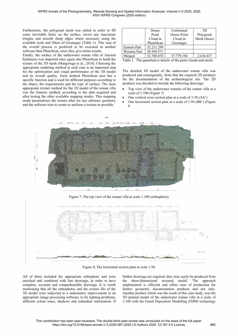
process. Moreover, a mask was applied to every image, as a frame to the edges of it, in order to exclude the part of each image that was mostly affected by the radial distortion of the camera. More masks were applied to images that captured fishes or swimmers. The next step was the detection of the premarked targets and then the alignment of the images. The premarked targets were used at this point as common points in order to connect the images and the strips. The accuracy of this step was chosen to be of medium quality and the pair selection choice was set to disabled mode. After that, the appropriate coordinates were added for each target in order to assign scale and georeference each sparse cloud. The accuracy of the coordinates was set at 3cm and some of the targets did not participate in the procedure in order to use them as control points for the final products of the documentation (Skarlatos et al., 2019). Any deviations that arose had to be checked at this step of the process. The overall accuracy was 4.4 cm and the GSD was 2.65μm. Next, the production of the dense point cloud followed based on the estimated camera locations (Figure 5). At this step, the accuracy was chosen to be of low quality in order to reduce the estimated time which the software needed for this process due to the large amount of data. It is worth mentioning at this point that each step of the overall process is a rather time-consuming step and requires a great deal of computational power, without giving accurate results at every attempt. Consequently, the process had to be repeated several times to make changes to the parameters, corrections and improvements in order to have the optimum results.
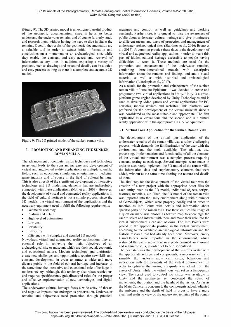
Figure 5: The aligned photos and the dense point cloud. After the production of both the eastern and western dense point cloud of the underwater remains, they were extracted and further processed in Geomagic Studio 2014. The two point clouds were merged by identifying common points, premarked targets and characteristic points, and not by using the geodetic measurements since their accuracy was already estimated at 3cm. Then the merged dense cloud was reduced, uniformed and the unnecessary noise was removed by applying the available filters of selecting and deleting the outliers as well as the noise reduction filter with respect to surface curvature for free-form shapes so as to retain the geometry, features and details of the underwater remains. Afterwards, the reconstruction of the 3D polygonal mesh followed based on the dense point cloud (Figure 6).
Figure 6: Part of the 3D polygonal mesh of the roman villa.
ISPRS Annals of the Photogrammetry, Remote Sensing and Spatial Information Sciences, Volume V-2-2020, 2020 XXIV ISPRS Congress (2020 edition)
This contribution has been peer-reviewed. The double-blind peer-review was conducted on the basis of the full paper. https://doi.org/10.5194/isprs-annals-V-2-2020-981-2020 | © Authors 2020. CC BY 4.0 License.
984
Furthermore, the polygonal mesh was edited in order to fill some inevitable holes on the surface, invert any inaccurate tringles and smooth sharp edges where necessary using the available tools and filters of Geomagic (Table 1). This step of the overall process is preferred to be executed in another software than PhotoScan, since they give better results. Finally, the surface of the underwater roman villa of Ancient Epidaurus was imported once again into PhotoScan to build the texture of the 3D mesh (Mangeruga et al., 2018). Choosing the appropriate rendering method in each case is an important step for the optimisation and visual performance of the 3D model and its overall quality. Each method PhotoScan uses has a specific function and is used for different purposes according to the object, the requirements and the type of surface. The most appropriate texture method for the 3D model of the roman villa was the Generic method, according to the data acquired and after testing the other available mapping modes. This mapping mode parametrises the texture atlas for any arbitrary geometry and the software tries to create as uniform a texture as possible.
Dense Point
Cloud in PhotoScan
Uniformed Dense Point
Cloud in Geomagic
3D Polygonal
Mesh (faces)
Eastern Part 32.211.299 Western Part 20.569.571 Merged 52.780.870 37.779.194 2.634.437
Table 1. The quantitative details of the point clouds and mesh.
The detailed 3D model of the underwater roman villa was produced and consequently, from that the required 2D products for the documentation of the archaeological site. The 2D products was decided to include the following drawings:
Top view of the underwater remains of the roman villa at a scale of 1:100 (Figure 7)
One vertical cross section plan at a scale of 1:50 (AA’) One horizontal section plan at a scale of 1:50 (BB’) (Figure
8
Figure 7: The top view of the roman villa at scale 1:100 (orthophoto).
Figure 8: The horizontal section plan at scale 1:50.
All of them included the appropriate orthophoto and were enriched and combined with line drawings, in order to have complete, accurate and comprehensible drawings. It is worth mentioning that all the orthophotos and the texture file of the 3D model were subjected to a radiometric improvement in an appropriate image processing software, to fix lighting problems, different colour tones, shadows and redundant information. If
further drawings are required, they may easily be produced from the three-dimensional textured model. The approach implemented is efficient and offers ease of production for further geometric documentation products and not only. Another product which was the result of this case study, was the 3D printed model of the underwater roman villa at a scale of 1:100 with the Fused Deposition Modelling (FDM) technology
ISPRS Annals of the Photogrammetry, Remote Sensing and Spatial Information Sciences, Volume V-2-2020, 2020 XXIV ISPRS Congress (2020 edition)
This contribution has been peer-reviewed. The double-blind peer-review was conducted on the basis of the full paper. https://doi.org/10.5194/isprs-annals-V-2-2020-981-2020 | © Authors 2020. CC BY 4.0 License.
985
(Figure 9). The 3D printed model is an extremely useful product of the geometric documentation, since it helps to better understand the underwater remains and of course furtherly study and research them, without having the need to dive in situ at the remains. Overall, the results of the geometric documentation are a valuable tool in order to extract initial information and conclusions on a monument or an archaeological site, while they enable the constant and easy access and retrieval of information at any time. In addition, exporting a variety of products, such as drawings and structural details, can be a quick and easy process as long as there is a complete and accurate 3D model.
Figure 9: The 3D printed model of the sunken roman villa.
3. PROMOTING AND ENHANCING THE SUNKEN
ROMAN VILLA
The advancement of computer vision techniques and technology in general leads to the constant increase and development of virtual and augmented reality applications in multiple scientific fields, such as education, simulation, entertainment, medicine, game industry and of course in the field of cultural heritage. This is also a result of the significant development of interactive technology and 3D modelling, elements that are indissolubly connected with these applications (Noh et al., 2009). However, the development of virtual and augmented reality applications in the field of cultural heritage is not a simple process, since the 3D models, the virtual environment of the applications and the necessary equipment need to fulfil the following requirements: Geometric accuracy Realism and detail High level of automation Low cost Portability Flexibility Efficiency with complex and detailed 3D models Nowadays, virtual and augmented reality applications play an essential role in achieving the main objectives of an archaeological site or museum, which are their social, economic and educational nature. Modern technology and digitisation create new challenges and opportunities, require new skills and constant development, in order to attract a wider and more diverse public in the field of cultural heritage and increase, at the same time, the interactive and educational role of heritage in modern society. Although, this tendency also raises restrictions and requires specifications, guidelines and rules for the proper and effective implementation of new technologies and digital applications. The underwater cultural heritage faces a wide array of threats and negative impacts that endanger its preservation. Underwater remains and shipwrecks need protection through practical
measures and control, as well as guidelines and working standards. Furthermore, it is crucial to raise the awareness of public about underwater cultural heritage and give prominence to different means and ways of protection and management of underwater archaeological sites (Skarlatos et al., 2016; Bruno et al., 2017). A common practice these days is the development of virtual and augmented reality applications in order to make this part of hidden cultural heritage accessible to people having difficulties to reach it. These methods are used for the promotion and enhancement of the underwater remains, combining three-dimensional models with descriptive information about the remains and findings and audio visual material, as well as with historical and archaeological information (Liarokapis et al., 2017). As a result, for the promotion and enhancement of the sunken roman villa of Ancient Epidaurus it was decided to create and programme two virtual applications in Unity. Unity is a cross-platform game engine developed by Unity Technologies and is used to develop video games and virtual applications for PC, consoles, mobile devices and websites. This platform was preferred for the development of the virtual museum since it was considered as the most suitable and appropriate. The first application is a virtual tour and the second one is a virtual reality application with the appropriate HTC Vive equipment. 3.1 Virtual Tour Application for the Sunken Roman Villa
The development of the virtual tour application of the underwater remains of the roman villa was a rather challenging process, which demands the familiarisation of the user with the environment and the tools available. The addition, use, processing, implementation and functionality of all the elements of the virtual environment was a complex process requiring constant testing at each step. Several attempts were made in order to accurately implement the 3D model of the roman villa, the information, data and supplementary elements that were added, without at the same time altering the texture and details of them. The first step for the development of the virtual tour was the creation of a new project with the appropriate Asset files for each entity, such as the 3D model, individual objects, scripts, textures, materials, etc. Then, the 3D model of the roman villa was imported into the Unity environment along with a number of GameObjects, which were properly configured in order to function as Info Points with details and information about specific parts of the roman villa. For these entities the image of a question mark was chosen as texture map to encourage the user to select and interact with them and make their role into the virtual environment clear and obvious. The Info Points were placed to the appropriate position in the virtual environment, according to the available archaeological information and the historic research that had already been done. Moreover, empty GameObjects were imported in the environment, which restricted the user's movement in a predetermined area around and within the villa, in order not to be disorientated. The next step was the development of the visitor’s avatar with the appropriate settings and components, a necessary entity to simulate the visitor’s movement, vision, behaviour and interaction with the elements of the virtual environment. In order to optimise the visitor, a capsule was added from the assets of Unity, while the virtual tour was set as a first-person view. The script used to control the visitor was available in Unity and the parameters set concerned the speed of movements, the rotation and the height of the visitor. As far as the Main Camera is concerned, the components added, adjusted the ambience and the depth of field in order to have a more clear and realistic view of the underwater remains of the roman
ISPRS Annals of the Photogrammetry, Remote Sensing and Spatial Information Sciences, Volume V-2-2020, 2020 XXIV ISPRS Congress (2020 edition)
This contribution has been peer-reviewed. The double-blind peer-review was conducted on the basis of the full paper. https://doi.org/10.5194/isprs-annals-V-2-2020-981-2020 | © Authors 2020. CC BY 4.0 License.
986
villa. Furthermore, the proper scripts were added as components to every Info Point in order to achieve the interaction and emergence of information when the visitor selects each one. The information is based on the historic documentation and research which was carried out for this case study, some of which refer to construction phases resulting from the geometric documentation and the in situ observations. A script was also written to allow the visitor to exit the virtual tour by pressing the Esc key. Particular attention was given to the formation and design of the panel displaying the instructions of the virtual tour at the beginning of the virtual experience in order to guide and help the visitor explore the environment. Finally, the last element added in the virtual environment was a mini-map to help the visitor move, orientate in the environment and detect at the same time the location of the Info Points (Figure 10).
Figure 10: The environment of the virtual tour application. 3.2 Virtual Reality Application with HTC Vive
The evolution of the virtual tour application is the development of a virtual reality application using the appropriate equipment in order to fully immerse the visitor into the virtual environment for an even more realistic and appealing experience. This was the reason that led to the development of a virtual reality application with the use HTC Vive. The HTC Vive is a virtual reality headset developed by HTC and Valve Corporation. The headset uses "room scale" tracking technology, allowing the user to move in 3D space and use motion-tracked handheld controllers to interact with the environment, completely cut off the real physical space. The virtual reality application or the sunken roman villa of Ancient Epidaurus was also implemented in Unity, in a similar way as the virtual tour application was developed. Likewise, in the case of the virtual reality application, the virtual environment was the first to be formed by importing the 3D model of the roman villa into the environment of Unity. The 3D model was configured by adding the appropriate scripts in order to enable the visitor to walk virtually on the underwater remains, when he/she walks in the real, physical space (Figure 11). Moreover, a script which is available in StreamVR was used so as the visitor teleports into the virtual environment of the roman villa simply by using the Vive Controllers. Another important element added in the virtual environment of the application was an appropriate sign to key areas signifying important parts of the roman villa, to inform the visitor about them (Figure 12). In this application, detailed text was not added, but only some signs were inserted in the form of title, which the visitor can only approach and read. The scripts used for the development of the virtual application for the underwater remains of the roman villa are available in the SteamVR library. Additional features and components may be added in the virtual environment in order to improve the user’s experience and make the application even more appealing and interactive. However, this requires
further programming and familiarity with the HTC Vive equipment.
Figure 11: The visitor walks in the physical space and virtually explores the underwater remains.
Figure 12: The signs indicating important parts of the villa in the virtual environment.
4. CONCLUDING REMARKS
Underwater cultural heritage is an important and distinct part of cultural heritage, while the means and ways of its protection, enhancement and management have not been entirely explored or implemented yet. It is important to highlight that the underwater remains and findings are not cut off from the rest of the land antiquities and findings and they should be linked to other archaeological sites in order to develop archaeological networks. The public should be informed about this part of the hidden cultural heritage so as to raise awareness, become active and participate in their protection and management. The objective of this case study was the documentation, the enhancement and management of underwater cultural heritage, through the process of the geometric documentation and the development of alternative and innovative products like virtual reality applications. The main axis was the exploitation and utilisation of computer vision algorithms, modern technology and low-cost equipment implemented for the geometric documentation of the underwater remains of the roman villa in Ancient Epidaurus and the development of virtual reality applications. The 3D digitisation and documentation of cultural heritage is a rather challenging and complicated process in general, which requires detail and precision. The process can be even more difficult when it comes to underwater cultural heritage. Both the acquisition and processing of the data are demanding and time-consuming processes. Several attempts with different means and methods, were made in order to
ISPRS Annals of the Photogrammetry, Remote Sensing and Spatial Information Sciences, Volume V-2-2020, 2020 XXIV ISPRS Congress (2020 edition)
This contribution has been peer-reviewed. The double-blind peer-review was conducted on the basis of the full paper. https://doi.org/10.5194/isprs-annals-V-2-2020-981-2020 | © Authors 2020. CC BY 4.0 License.
987
overcome the problems and difficulties of the underwater environment and achieve the best results. The development of virtual reality applications as a way of enhancement and promotion of the underwater roman villa of Ancient Epidaurus were the main products of this case study. The development of such applications demands the cooperation of various professionals, such as architects, computer programmers, archaeologists, museum curators and many others in order to have a complete, impressive, interactive and educational result accessible to the public and easy to use. Both the virtual tour and the virtual reality application with the use of HTC Vive offer to the user the opportunity to virtually visit the underwater remains of the roman villa. The results are pretty good and very tempting for the user, however many changes and improvements could be made. The configuration of the Points of Interest in the virtual environment as well as the display of the information enriched with audio visual material are some of the improvements that could be made. Furthermore, the information displayed in the virtual reality application could only appear as an additional menu by the controller when the user chose to, so as not to interfere with the virtual experience. If an excavation had been made in the underwater archaeological site, the application could include an additional option where the user could be virtually teleported to the reconstructed 3D model of the roman villa and navigate in the environment during the late roman period. Finally, another improvement would be the development of a virtual network that would link and connect all the archaeological sites and findings of the Ancient Epidaurus, both in land and sea.
REFERENCES
Agrafiotis, P.; Karantzalos, K.; Georgopoulos, A.; Skarlatos, D. Correcting Image Refraction: Towards Accurate Aerial Image-Based Bathymetry Mapping in Shallow Waters. Remote Sens. 2020, 12, 322. Agrafiotis, P.; Skarlatos, D.; Georgopoulos, A.; Karantzalos, K. DepthLearn: Learning to Correct the Refraction on Point Clouds Derived from Aerial Imagery for Accurate Dense Shallow Water Bathymetry Based on SVMs-Fusion with LiDAR Point Clouds. Remote Sens. 2019, 11, 2225 Agrafiotis, P., Skarlatos, D., Forbes, T., Poullis, C., Skamantzari, M., & Georgopoulos, A. (2018). Underwater photogrammetry in very shallow waters: main challenges and caustics effect removal. International Archives of the Photogrammetry, Remote Sensing and Spatial Information Sciences, 42, 2. Avramea A., 2012: Peloponesse from the 4th to 8th c.AD; Changes and continuity. Educational Foundation of the National Bank of Greece (MIET). Bruno, F., Lagudi, A., Ritacco, G., Agrafiotis, P., Skarlatos, D., Čejka, J., Kouril P., Liarokapis F., Philpin-Briscoe O., Poulis C., Bart S. & Mudur, S. (2017, June). Development and integration of digital technologies addressed to raise awareness and access to European underwater cultural heritage. An overview of the H2020 i-MARECULTURE project. In OCEANS 2017-Aberdeen (pp. 1-10). IEEE. Ellis S.P., 2000. Roman Housing. Published by Gerald Duckworth & Co. Ltd., United Kingdom, ISBN: 0-7156-2877-1.
Flemming N., Czartoryska N.M.G., Hunter P.M., 1971. Archaeological Evidence for Eustatic and Tectonic Components of Relative Sea-level Changes in the South Aegean. Marine Archaeology, proceedings of the Twenty-third Symposium of the Colston Research Society held in the University of Bristol, April 4th to 8th, 1971. Georgopoulos, A., & Agrafiotis, P. (2012, September). Documentation of a submerged monument using improved two media techniques. In 2012 18th International Conference on Virtual Systems and Multimedia (pp. 173-180). IEEE. Ginouvès René, 1998. Dictionnaire méthodique de l’architecture grecque et romaine. Tome III. Espaces architecturaux, bâtiments et ensembles. Préface de René Ginouvès et Marie-Christine Hellmann. Rome : École Française de Rome, 1998, 492 p. (Publications de l’École française de Rome, 84). Kritzas B. Charalampos, 1972. Athens Annals of Archaeology. Tome V, Vol. 1, pp. 187-199. Liarokapis, F., Kouřil, P., Agrafiotis, P., Demesticha, S., Chmelik, J., & Skarlatos, D. (2017). 3D modelling and mapping for virtual exploration of underwater archaeology assets. The International Archives of Photogrammetry, Remote Sensing and Spatial Information Sciences, 42, 425. Mangeruga, M., Bruno, F., Cozza, M., Agrafiotis, P., & Skarlatos, D. (2018). Guidelines for underwater image enhancement based on benchmarking of different methods. Remote Sensing, 10 (10), 1652. Menna, F., Agrafiotis, P., & Georgopoulos, A. (2018). State of the art and applications in archaeological underwater 3D recording and mapping. Journal of Cultural Heritage, 33, 231-248. McKay A.G., 1975. Houses, Villas and Palaces in the Roman World. Published by Cornell University Press, London, ISBN: 0-8018-5904-2. Said W.B., 2002. Typology of the roman period houses in the Eastern Mediterranean. Doctoral Thesis, National Technical University of Athens, School of Architecture, Athens, Greece. Skarlatos, D., Menna, F., Nocerino, E., & Agrafiotis, P. (2019). Precision potential of underwater networks for archaeological excavation through trilateration and photogrammetry. International Archives of the Photogrammetry, Remote Sensing and Spatial Information Sciences, 42(2/W10). Skarlatos, D., Agrafiotis, P., Balogh, T., Bruno, F., Castro, F., Petriaggi, B. D., ... & Kikillos, F. (2016, October). Project iMARECULTURE: advanced VR, iMmersive serious games and augmented REality as tools to raise awareness and access to European underwater CULTURal heritagE. In Euro-Mediterranean Conference (pp. 805-813). Springer, Timár L., 2011. The Spread of the Roman Domus-Type in Gaul. Published by Archaeopress, Publishers of British Archaeological Reports, England, ISBN: 978-1-4073-0764-0.
ISPRS Annals of the Photogrammetry, Remote Sensing and Spatial Information Sciences, Volume V-2-2020, 2020 XXIV ISPRS Congress (2020 edition)
This contribution has been peer-reviewed. The double-blind peer-review was conducted on the basis of the full paper. https://doi.org/10.5194/isprs-annals-V-2-2020-981-2020 | © Authors 2020. CC BY 4.0 License.
988


![[Challenge:Future] Quest for Sunken Bell](https://img.pdfslide.us/doc/110x75/58f090031a28ab0a498b46b1/challengefuture-quest-for-sunken-bell.jpg)