Embed Size (px)
Citation preview
C-1
Summary of Selected Water Budget Models
The following is a brief review of selected water budget models, including surface (Section C1) andgroundwater (Section C2) models, presented in a tabulated format. The purpose of the review is toprovide a profile on each model, and to indicate the availability of the model and its applicability foruse in water budget analysis. The onus is on the practitioner to decide whether the level of detail ineach model meets the specific project requirements for water balance analysis.

C-2
Table of Contents
Page
C1: Surface Water Models
HEC-HMS - Hydrological Modelling System............................................4SWMM - Storm Water Management Model..........................................5SWAT - Soil and Water Assessment Tool ...........................................6QUALHYMO - Storm Water Runoff Model...................................................7HSPF - Hydrological Simulation Program Fortran..............................8AGNPS - Agricultural Non-Point Source Pollution Model......................9SHE - The European Hydrologic System....................................... 10PRMS - Precipitation Runoff Modelling System................................ 11SSARR - Streamflow Synthesis and Reservoir Regulation Model......... 12HELP - Hydrological Evaluation of Landfill Performance ................. 13WATER BUDGET - Cumming Cockburn Limited Water Budget Model............... 14ANSWERS - Areal Non-Point Source Watershed Environment
Response Simulation .......................................................... 15GAWSER(GRIFFS) - Guelph All-Weather Storm Event Runoff Model................... 16CREAMS - Chemicals, Runoff & Erosion from Agricultural
Management Systems ........................................................ 17USGS - Design Storm Model.......................................................... 18SWIM - Soil Water Infiltration and Movement.................................. 19GLEAMS - Groundwater Loading Effects of Agricultural
Management System.......................................................... 20Q-ILLUDAS - Simulation of Urban Runoff and Pollutant Loading
from the Great Lake Catchment Area................................... 21NPSMAP - Non-Point Pollution Source Model for Analysis and
Planning............................................................................ 22GWLF - Generalized Watershed Loading Functions ........................... 23P8-UCM - Urban Catchment Model..................................................... 24PRZMC-26 - Pesticide Root Zone Model................................................. 25SLAMM - Source Loading and Management Model............................. 26UTM-TOX - Unified Transport Model for Toxic Materials ....................... 27SWRBB - Simulation for Water Resources in Rural Basins ................... 28QHM - Continuous Watershed Modelling/Storm Management
System.............................................................................. 29WMS - Watershed Modelling System.............................................. 30Summary Sheet - Surface Water Models ........................................................ 31

C-3
Table of Contents (continued)
Page
C2: Groundwater Models
BIOPLUME - Transport of Dissolved Hydrocarbons ............................ 32CHEMFLO - Chemical Movement in Unsaturated Soils ...................... 32VLEACH - Vadose Zone Leaching Model....................................... 32STF - Soil Transport and Fate, Regulatory and Investigative...... 32MOFAT - Multiphase Flow and Multicomponent Transport ............ 33FEMWATER/LEWASTE - Wellhead Protection Model........................................... 33PRZM-2 - Pesticide Transport Model............................................. 33MULTIMED - Multimedia Exposure Assessment Model....................... 33PESTAN - Transport of Organic Solutes Model............................... 33RETC - Retention Curve Model – Soil Water Retention............... 34WHAEM - Groundwater Wellhead Protection Model....................... 34WHPA - A Semi-Analytical Model for Groundwater Flow............ 34MODFLOW - 3-D Finite-Difference Groundwater Flow Model............. 34MT3D - A Modular 3-D Solute Transport Model......................... 34CZAEM - Confined and Unconfined in Shallow Aquifers ............... 35UNSODA - Saturated and Unsaturated Hydraulic Properties
Database ..................................................................... 35Summary Sheet - Groundwater Models - Part A ....................................... 36
- Groundwater Models - Part B........................................ 37
C-4
C1 Surface Water Models
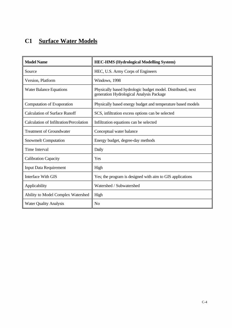
Model Name HEC-HMS (Hydrological Modelling System)
Source HEC, U.S. Army Corps of Engineers
Version, Platform Windows, 1998
Water Balance Equations Physically based hydrologic budget model. Distributed, nextgeneration Hydrological Analysis Package
Computation of Evaporation Physically based energy budget and temperature based models
Calculation of Surface Runoff SCS, infiltration excess options can be selected
Calculation of Infiltration/Percolation Infiltration equations can be selected
Treatment of Groundwater Conceptual water balance
Snowmelt Computation Energy budget, degree-day methods
Time Interval Daily
Calibration Capacity Yes
Input Data Requirement High
Interface With GIS Yes; the program is designed with aim to GIS applications
Applicability Watershed / Subwatershed
Ability to Model Complex Watershed High
Water Quality Analysis No

C-5
Model Name Storm Water Management Model (SWMM)(designed specifically for urbanized watersheds)
Source US EPA
Version, Platform SWMM 4
Water Balance Equations Generalized water budget
Computation of Evaporation Energy budget approach
Calculation of Surface Runoff SCS method and infiltration equations
Calculation of Infiltration/Percolation Infiltration equations
Treatment of Groundwater Simplified water balance approach
Snowmelt Computation Energy budget, degree-day methods
Time Interval Daily and smaller time steps for storms
Calibration Capacity Yes
Input Data Requirement Watershed characteristics, soil type, vegetation type, precipitationand temperature
Interface With GIS Yes; interface with ArcView
Applicability Subwatershed / Site plan
Ability to Model Complex Watershed High
Water Quality Analysis Yes
C-6
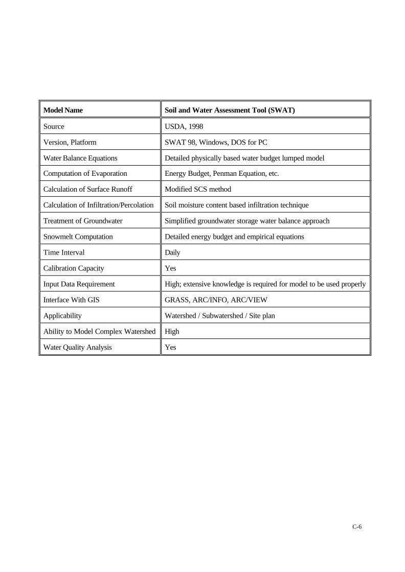
Model Name Soil and Water Assessment Tool (SWAT)
Source USDA, 1998
Version, Platform SWAT 98, Windows, DOS for PC
Water Balance Equations Detailed physically based water budget lumped model
Computation of Evaporation Energy Budget, Penman Equation, etc.
Calculation of Surface Runoff Modified SCS method
Calculation of Infiltration/Percolation Soil moisture content based infiltration technique
Treatment of Groundwater Simplified groundwater storage water balance approach
Snowmelt Computation Detailed energy budget and empirical equations
Time Interval Daily
Calibration Capacity Yes
Input Data Requirement High; extensive knowledge is required for model to be used properly
Interface With GIS GRASS, ARC/INFO, ARC/VIEW
Applicability Watershed / Subwatershed / Site plan
Ability to Model Complex Watershed High
Water Quality Analysis Yes
C-7
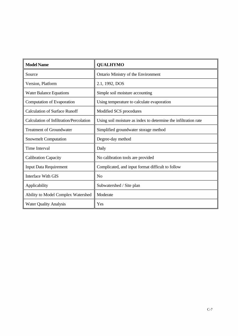
Model Name QUALHYMO
Source Ontario Ministry of the Environment
Version, Platform 2.1, 1992, DOS
Water Balance Equations Simple soil moisture accounting
Computation of Evaporation Using temperature to calculate evaporation
Calculation of Surface Runoff Modified SCS procedures
Calculation of Infiltration/Percolation Using soil moisture as index to determine the infiltration rate
Treatment of Groundwater Simplified groundwater storage method
Snowmelt Computation Degree-day method
Time Interval Daily
Calibration Capacity No calibration tools are provided
Input Data Requirement Complicated, and input format difficult to follow
Interface With GIS No
Applicability Subwatershed / Site plan
Ability to Model Complex Watershed Moderate
Water Quality Analysis Yes
C-8
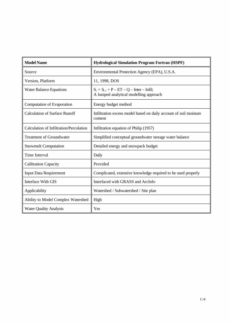
Model Name Hydrological Simulation Program Fortran (HSPF)
Source Environmental Protection Agency (EPA), U.S.A.
Version, Platform 11, 1998, DOS
Water Balance Equations St = St-1 + P – ET – Q – Inter – Infil;A lumped analytical modelling approach
Computation of Evaporation Energy budget method
Calculation of Surface Runoff Infiltration excess model based on daily account of soil moisturecontent
Calculation of Infiltration/Percolation Infiltration equation of Philip (1957)
Treatment of Groundwater Simplified conceptual groundwater storage water balance
Snowmelt Computation Detailed energy and snowpack budget
Time Interval Daily
Calibration Capacity Provided
Input Data Requirement Complicated, extensive knowledge required to be used properly
Interface With GIS Interfaced with GRASS and ArcInfo
Applicability Watershed / Subwatershed / Site plan
Ability to Model Complex Watershed High
Water Quality Analysis Yes

C-9
Model Name Agricultural Non-Point Source Pollution Model (AGNPS)
Source USDA, Natural Resources Conservation Service
Version, Platform Version 98, Windows, DOS and Unix
Water Balance Equations Simple soil moisture accounting. Distributed grid cell computation
Computation of Evaporation Simplified
Calculation of Surface Runoff SCS CN procedures
Calculation of Infiltration/Percolation Simplified SCS procedure
Treatment of Groundwater Not included
Snowmelt Computation Simplified computation based on snowmelt equation
Time Interval Daily
Calibration Capacity Provided
Input Data Requirement Rainfall time series, watershed parameters, requires extensiveknowledge to be used appropriately
Interface With GIS Interfaced with GRASS and ArcInfo
Applicability Watershed / Subwatershed
Ability to Model Complex Watershed High
Water Quality Analysis Yes
C-10
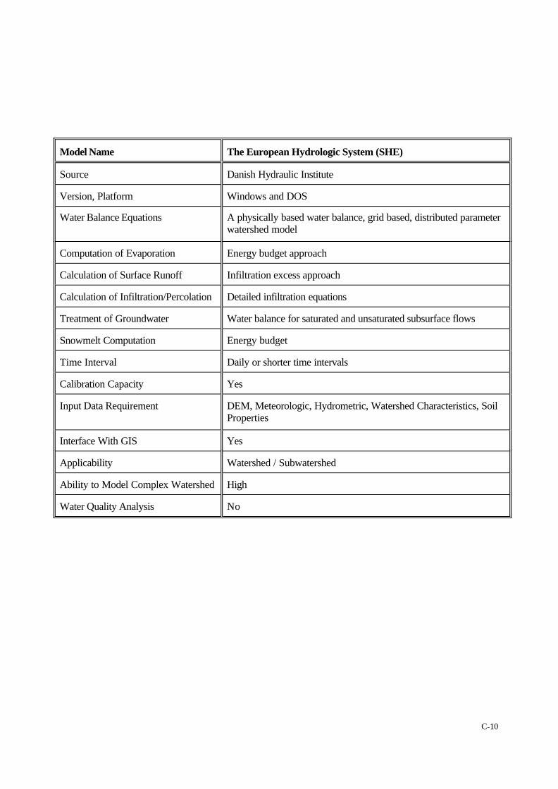
Model Name The European Hydrologic System (SHE)
Source Danish Hydraulic Institute
Version, Platform Windows and DOS
Water Balance Equations A physically based water balance, grid based, distributed parameterwatershed model
Computation of Evaporation Energy budget approach
Calculation of Surface Runoff Infiltration excess approach
Calculation of Infiltration/Percolation Detailed infiltration equations
Treatment of Groundwater Water balance for saturated and unsaturated subsurface flows
Snowmelt Computation Energy budget
Time Interval Daily or shorter time intervals
Calibration Capacity Yes
Input Data Requirement DEM, Meteorologic, Hydrometric, Watershed Characteristics, SoilProperties
Interface With GIS Yes
Applicability Watershed / Subwatershed
Ability to Model Complex Watershed High
Water Quality Analysis No
C-11
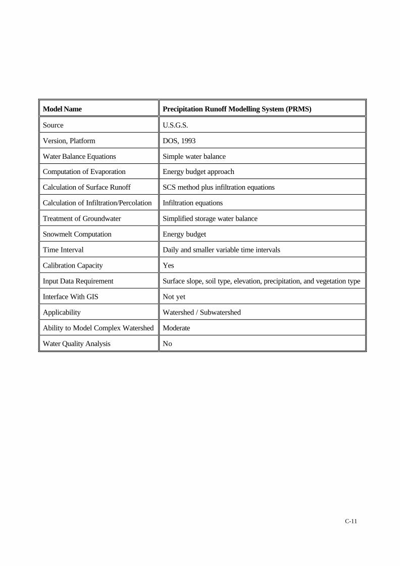
Model Name Precipitation Runoff Modelling System (PRMS)
Source U.S.G.S.
Version, Platform DOS, 1993
Water Balance Equations Simple water balance
Computation of Evaporation Energy budget approach
Calculation of Surface Runoff SCS method plus infiltration equations
Calculation of Infiltration/Percolation Infiltration equations
Treatment of Groundwater Simplified storage water balance
Snowmelt Computation Energy budget
Time Interval Daily and smaller variable time intervals
Calibration Capacity Yes
Input Data Requirement Surface slope, soil type, elevation, precipitation, and vegetation type
Interface With GIS Not yet
Applicability Watershed / Subwatershed
Ability to Model Complex Watershed Moderate
Water Quality Analysis No
C-12
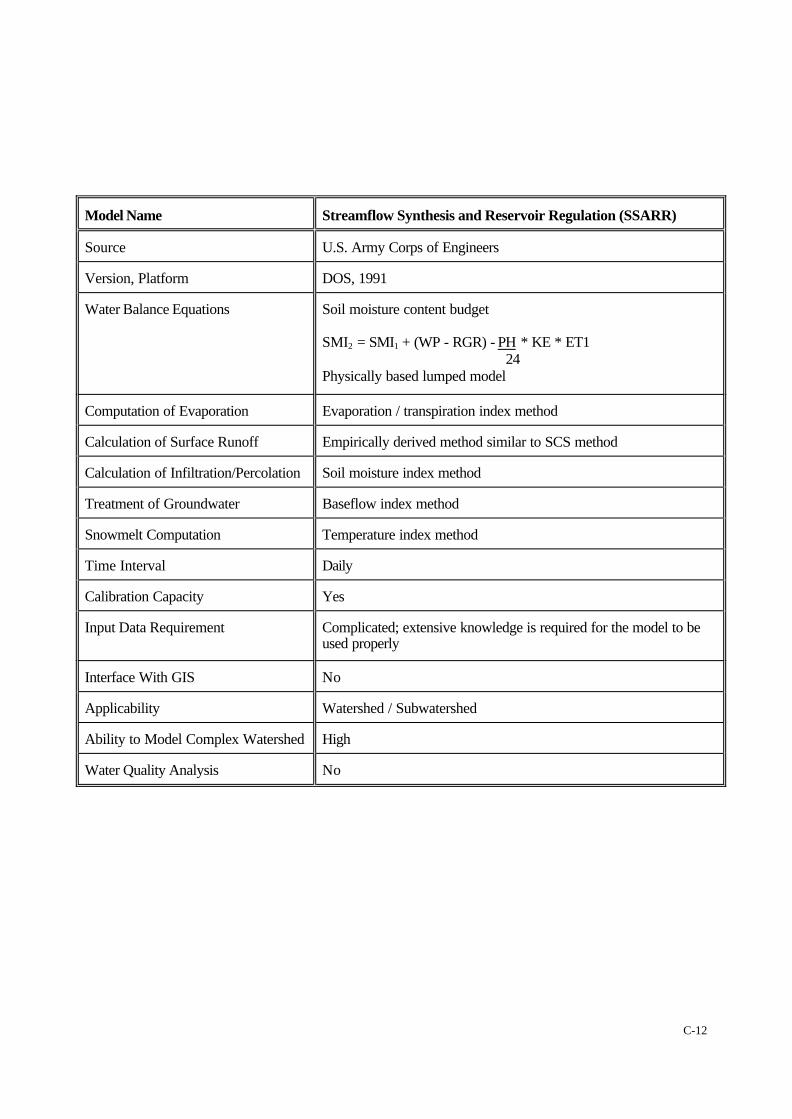
Model Name Streamflow Synthesis and Reservoir Regulation (SSARR)
Source U.S. Army Corps of Engineers
Version, Platform DOS, 1991
Water Balance Equations Soil moisture content budget
SMI2 = SMI1 + (WP - RGR) - PH * KE * ET1 24
Physically based lumped model
Computation of Evaporation Evaporation / transpiration index method
Calculation of Surface Runoff Empirically derived method similar to SCS method
Calculation of Infiltration/Percolation Soil moisture index method
Treatment of Groundwater Baseflow index method
Snowmelt Computation Temperature index method
Time Interval Daily
Calibration Capacity Yes
Input Data Requirement Complicated; extensive knowledge is required for the model to beused properly
Interface With GIS No
Applicability Watershed / Subwatershed
Ability to Model Complex Watershed High
Water Quality Analysis No
C-13
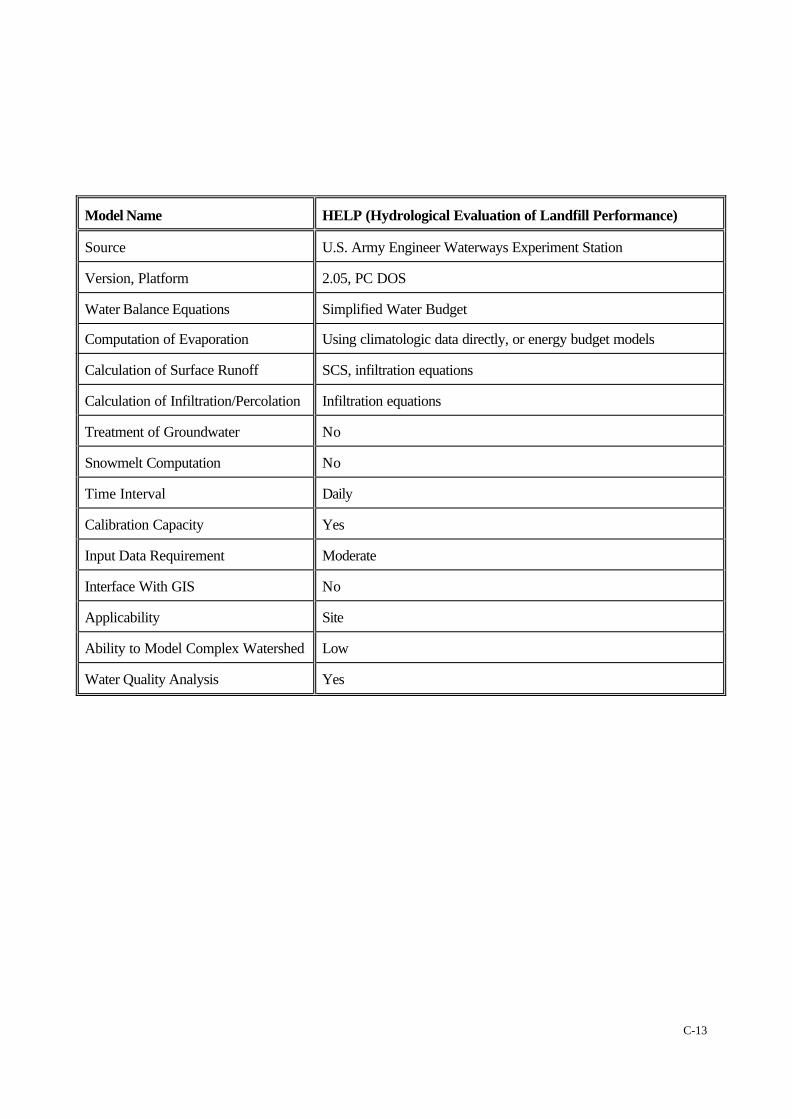
Model Name HELP (Hydrological Evaluation of Landfill Performance)
Source U.S. Army Engineer Waterways Experiment Station
Version, Platform 2.05, PC DOS
Water Balance Equations Simplified Water Budget
Computation of Evaporation Using climatologic data directly, or energy budget models
Calculation of Surface Runoff SCS, infiltration equations
Calculation of Infiltration/Percolation Infiltration equations
Treatment of Groundwater No
Snowmelt Computation No
Time Interval Daily
Calibration Capacity Yes
Input Data Requirement Moderate
Interface With GIS No
Applicability Site
Ability to Model Complex Watershed Low
Water Quality Analysis Yes

C-14
Model Name WATER BUDGET
Source Cumming Cockburn Limited
Version, Platform 1991, 1992, 1996, 1997, PC DOS
Water Balance Equations Equations change with the variables to be analyzed (may be sitespecific)
Computation of Evaporation Statistical input, measurement, energy budget
Calculation of Surface Runoff SCS, infiltration excess, saturation excess, or simple runoffcoefficient method
Calculation of Infiltration/Percolation Soil moisture content based infiltration technique
Treatment of Groundwater Groundwater storage balance approach
Snowmelt Computation Degree-day method
Time Interval Daily, monthly, annually or hourly
Calibration Capacity Yes
Input Data Requirement Moderate
Interface With GIS MapInfo, ArcView
Applicability Watershed / Subwatershed / Site plan
Ability to Model Complex Watershed High
Water Quality Analysis Yes
C-15
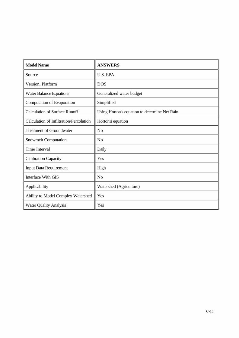
Model Name ANSWERS
Source U.S. EPA
Version, Platform DOS
Water Balance Equations Generalized water budget
Computation of Evaporation Simplified
Calculation of Surface Runoff Using Horton's equation to determine Net Rain
Calculation of Infiltration/Percolation Horton's equation
Treatment of Groundwater No
Snowmelt Computation No
Time Interval Daily
Calibration Capacity Yes
Input Data Requirement High
Interface With GIS No
Applicability Watershed (Agriculture)
Ability to Model Complex Watershed Yes
Water Quality Analysis Yes
C-16
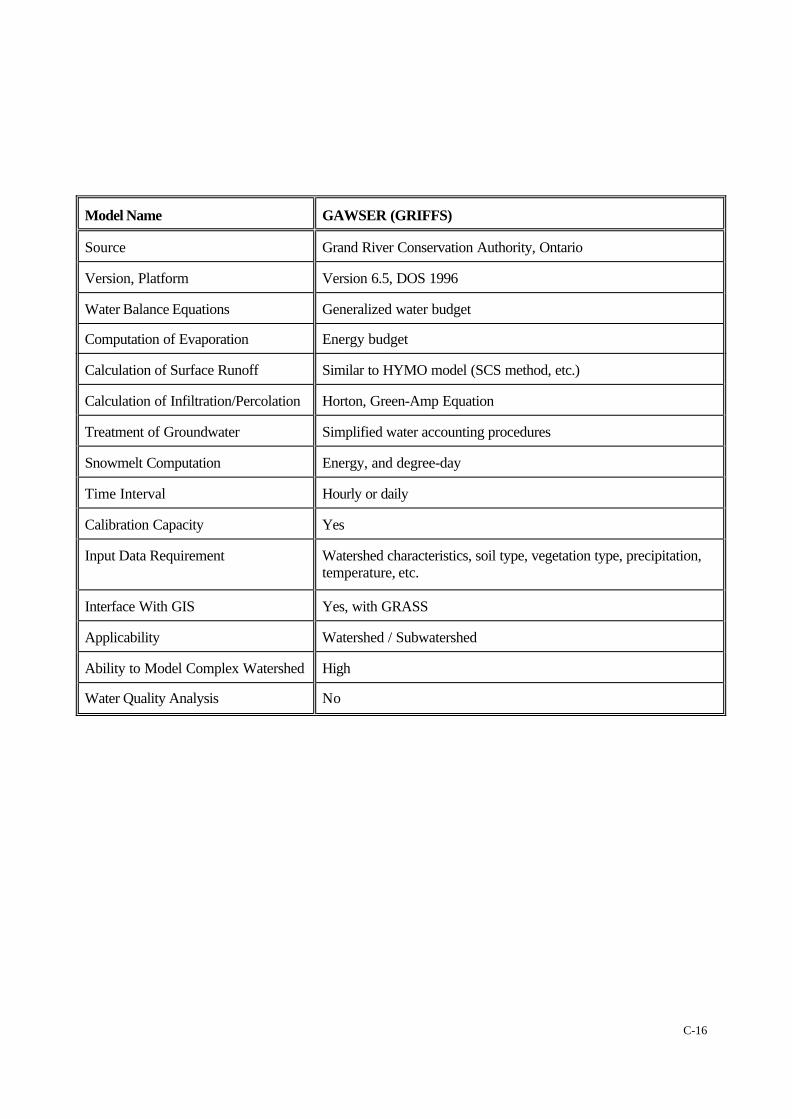
Model Name GAWSER (GRIFFS)
Source Grand River Conservation Authority, Ontario
Version, Platform Version 6.5, DOS 1996
Water Balance Equations Generalized water budget
Computation of Evaporation Energy budget
Calculation of Surface Runoff Similar to HYMO model (SCS method, etc.)
Calculation of Infiltration/Percolation Horton, Green-Amp Equation
Treatment of Groundwater Simplified water accounting procedures
Snowmelt Computation Energy, and degree-day
Time Interval Hourly or daily
Calibration Capacity Yes
Input Data Requirement Watershed characteristics, soil type, vegetation type, precipitation,temperature, etc.
Interface With GIS Yes, with GRASS
Applicability Watershed / Subwatershed
Ability to Model Complex Watershed High
Water Quality Analysis No

C-17
Model Name CREAMS (Chemicals, Runoff and Erosion from AgriculturalManagement Systems)
Source U.S. Department of Agriculture
Version, Platform DOS
Water Balance Equations Generalized water budget
Computation of Evaporation Measured pan evaporation
Calculation of Surface Runoff SCS method
Calculation of Infiltration/Percolation Infiltration equations.
Treatment of Groundwater Simplified accounting procedure
Snowmelt Computation No
Time Interval Daily
Calibration Capacity Yes
Input Data Requirement High
Interface With GIS No
Applicability Watershed / Subwatershed
Ability to Model Complex Watershed High
Water Quality Analysis Yes
C-18
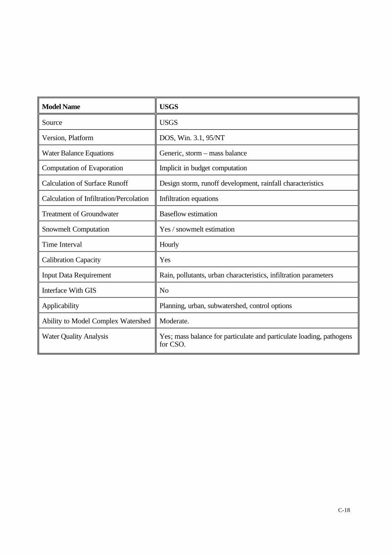
Model Name USGS
Source USGS
Version, Platform DOS, Win. 3.1, 95/NT
Water Balance Equations Generic, storm – mass balance
Computation of Evaporation Implicit in budget computation
Calculation of Surface Runoff Design storm, runoff development, rainfall characteristics
Calculation of Infiltration/Percolation Infiltration equations
Treatment of Groundwater Baseflow estimation
Snowmelt Computation Yes / snowmelt estimation
Time Interval Hourly
Calibration Capacity Yes
Input Data Requirement Rain, pollutants, urban characteristics, infiltration parameters
Interface With GIS No
Applicability Planning, urban, subwatershed, control options
Ability to Model Complex Watershed Moderate.
Water Quality Analysis Yes; mass balance for particulate and particulate loading, pathogensfor CSO.
C-19
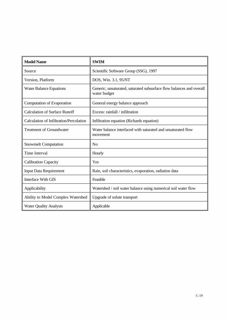
Model Name SWIM
Source Scientific Software Group (SSG), 1997
Version, Platform DOS, Win. 3.1, 95/NT
Water Balance Equations Generic; unsaturated, saturated subsurface flow balances and overallwater budget
Computation of Evaporation General energy balance approach
Calculation of Surface Runoff Excess: rainfall / infiltration
Calculation of Infiltration/Percolation Infiltration equation (Richards equation)
Treatment of Groundwater Water balance interfaced with saturated and unsaturated flowmovement
Snowmelt Computation No
Time Interval Hourly
Calibration Capacity Yes
Input Data Requirement Rain, soil characteristics, evaporation, radiation data
Interface With GIS Feasible
Applicability Watershed / soil water balance using numerical soil water flow
Ability to Model Complex Watershed Upgrade of solute transport
Water Quality Analysis Applicable
C-20
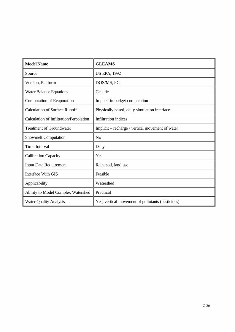
Model Name GLEAMS
Source US EPA, 1992
Version, Platform DOS/MS, PC
Water Balance Equations Generic
Computation of Evaporation Implicit in budget computation
Calculation of Surface Runoff Physically based, daily simulation interface
Calculation of Infiltration/Percolation Infiltration indices
Treatment of Groundwater Implicit – recharge / vertical movement of water
Snowmelt Computation No
Time Interval Daily
Calibration Capacity Yes
Input Data Requirement Rain, soil, land use
Interface With GIS Feasible
Applicability Watershed
Ability to Model Complex Watershed Practical
Water Quality Analysis Yes; vertical movement of pollutants (pesticides)
C-21
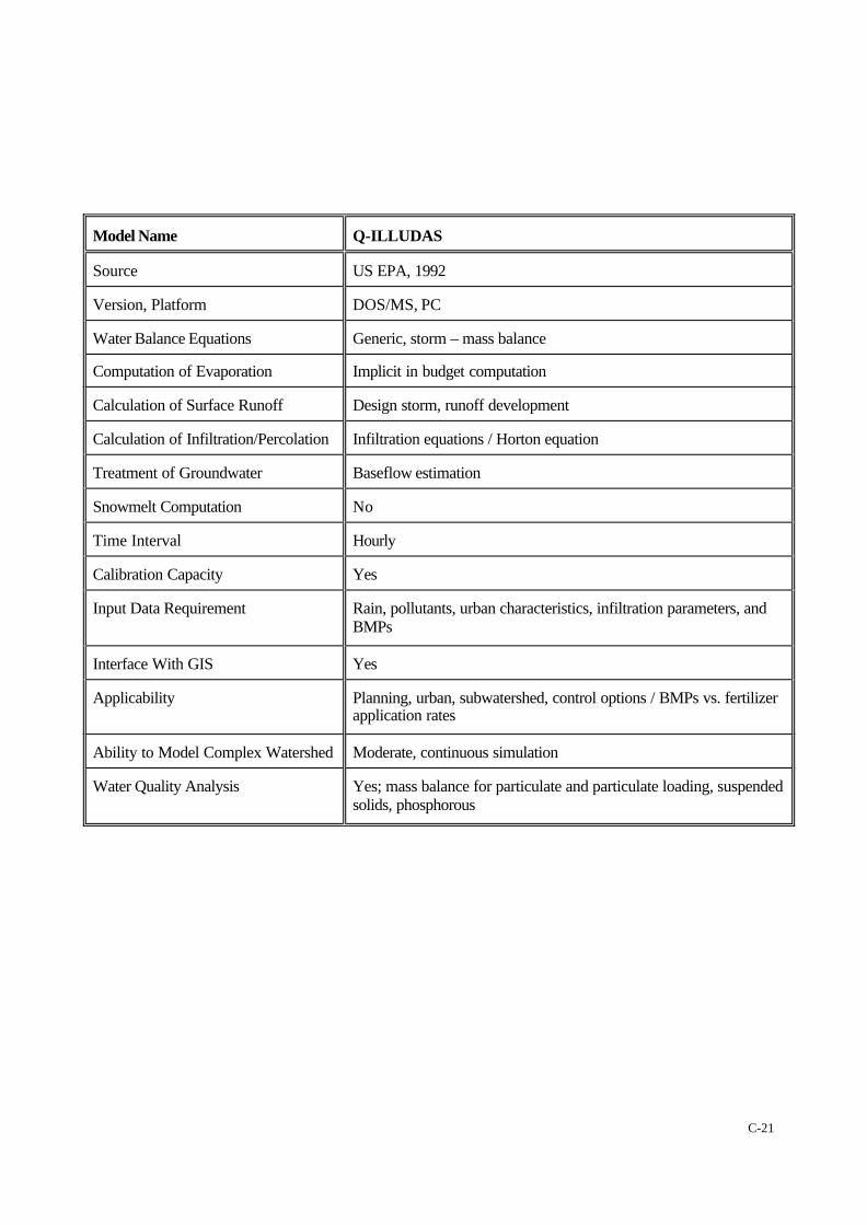
Model Name Q-ILLUDAS
Source US EPA, 1992
Version, Platform DOS/MS, PC
Water Balance Equations Generic, storm – mass balance
Computation of Evaporation Implicit in budget computation
Calculation of Surface Runoff Design storm, runoff development
Calculation of Infiltration/Percolation Infiltration equations / Horton equation
Treatment of Groundwater Baseflow estimation
Snowmelt Computation No
Time Interval Hourly
Calibration Capacity Yes
Input Data Requirement Rain, pollutants, urban characteristics, infiltration parameters, andBMPs
Interface With GIS Yes
Applicability Planning, urban, subwatershed, control options / BMPs vs. fertilizerapplication rates
Ability to Model Complex Watershed Moderate, continuous simulation
Water Quality Analysis Yes; mass balance for particulate and particulate loading, suspendedsolids, phosphorous
C-22
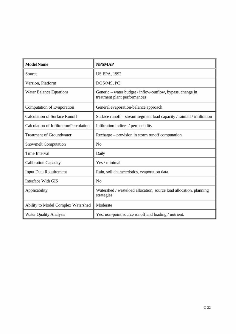
Model Name NPSMAP
Source US EPA, 1992
Version, Platform DOS/MS, PC
Water Balance Equations Generic – water budget / inflow-outflow, bypass, change intreatment plant performances
Computation of Evaporation General evaporation-balance approach
Calculation of Surface Runoff Surface runoff – stream segment load capacity / rainfall / infiltration
Calculation of Infiltration/Percolation Infiltration indices / permeability
Treatment of Groundwater Recharge – provision in storm runoff computation
Snowmelt Computation No
Time Interval Daily
Calibration Capacity Yes / minimal
Input Data Requirement Rain, soil characteristics, evaporation data.
Interface With GIS No
Applicability Watershed / wasteload allocation, source load allocation, planningstrategies
Ability to Model Complex Watershed Moderate
Water Quality Analysis Yes; non-point source runoff and loading / nutrient.

C-23
Model Name GWLF
Source US EPA, 1992
Version, Platform DOS/MS, PC
Water Balance Equations Generic
Computation of Evaporation Implicit in budget computation
Calculation of Surface Runoff Rainfall / runoff erosion and sediment generation
Calculation of Infiltration/Percolation Infiltration indices / permeability / impermeability
Treatment of Groundwater Implicit – recharge movement of water
Snowmelt Computation Yes
Time Interval Daily
Calibration Capacity Yes / minimal
Input Data Requirement Rain, soil, land use
Interface With GIS No
Applicability Watershed / planning / basin-wide management
Ability to Model Complex Watershed Moderate
Water Quality Analysis Yes; point and non-point pollutant loading
C-24
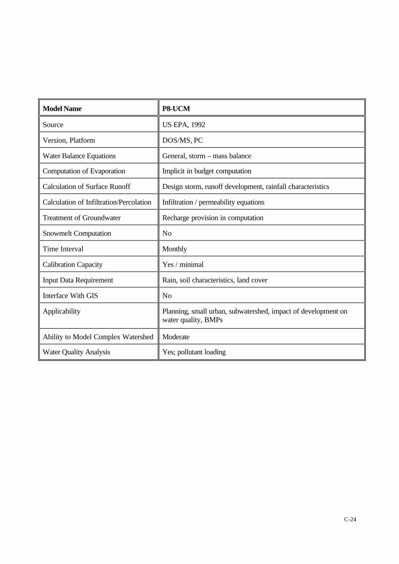
Model Name P8-UCM
Source US EPA, 1992
Version, Platform DOS/MS, PC
Water Balance Equations General, storm – mass balance
Computation of Evaporation Implicit in budget computation
Calculation of Surface Runoff Design storm, runoff development, rainfall characteristics
Calculation of Infiltration/Percolation Infiltration / permeability equations
Treatment of Groundwater Recharge provision in computation
Snowmelt Computation No
Time Interval Monthly
Calibration Capacity Yes / minimal
Input Data Requirement Rain, soil characteristics, land cover
Interface With GIS No
Applicability Planning, small urban, subwatershed, impact of development onwater quality, BMPs
Ability to Model Complex Watershed Moderate
Water Quality Analysis Yes; pollutant loading
C-25
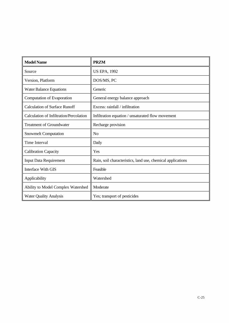
Model Name PRZM
Source US EPA, 1992
Version, Platform DOS/MS, PC
Water Balance Equations Generic
Computation of Evaporation General energy balance approach
Calculation of Surface Runoff Excess: rainfall / infiltration
Calculation of Infiltration/Percolation Infiltration equation / unsaturated flow movement
Treatment of Groundwater Recharge provision
Snowmelt Computation No
Time Interval Daily
Calibration Capacity Yes
Input Data Requirement Rain, soil characteristics, land use, chemical applications
Interface With GIS Feasible
Applicability Watershed
Ability to Model Complex Watershed Moderate
Water Quality Analysis Yes; transport of pesticides
C-26
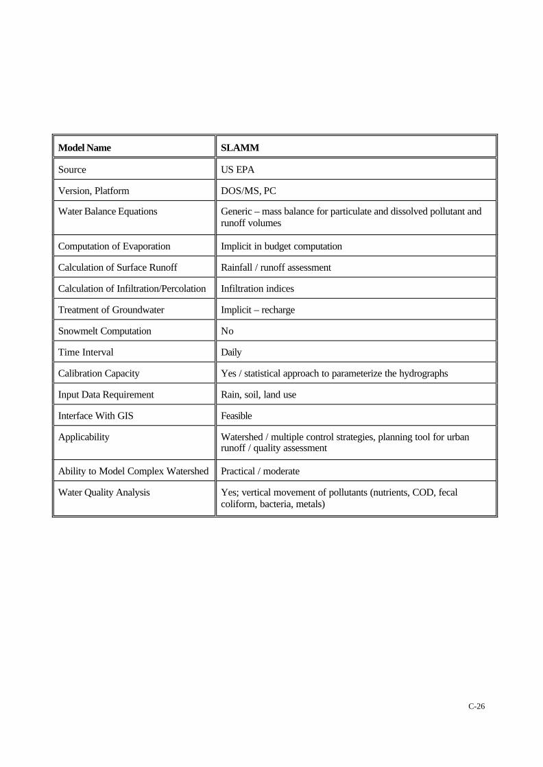
Model Name SLAMM
Source US EPA
Version, Platform DOS/MS, PC
Water Balance Equations Generic – mass balance for particulate and dissolved pollutant andrunoff volumes
Computation of Evaporation Implicit in budget computation
Calculation of Surface Runoff Rainfall / runoff assessment
Calculation of Infiltration/Percolation Infiltration indices
Treatment of Groundwater Implicit – recharge
Snowmelt Computation No
Time Interval Daily
Calibration Capacity Yes / statistical approach to parameterize the hydrographs
Input Data Requirement Rain, soil, land use
Interface With GIS Feasible
Applicability Watershed / multiple control strategies, planning tool for urbanrunoff / quality assessment
Ability to Model Complex Watershed Practical / moderate
Water Quality Analysis Yes; vertical movement of pollutants (nutrients, COD, fecalcoliform, bacteria, metals)
C-27
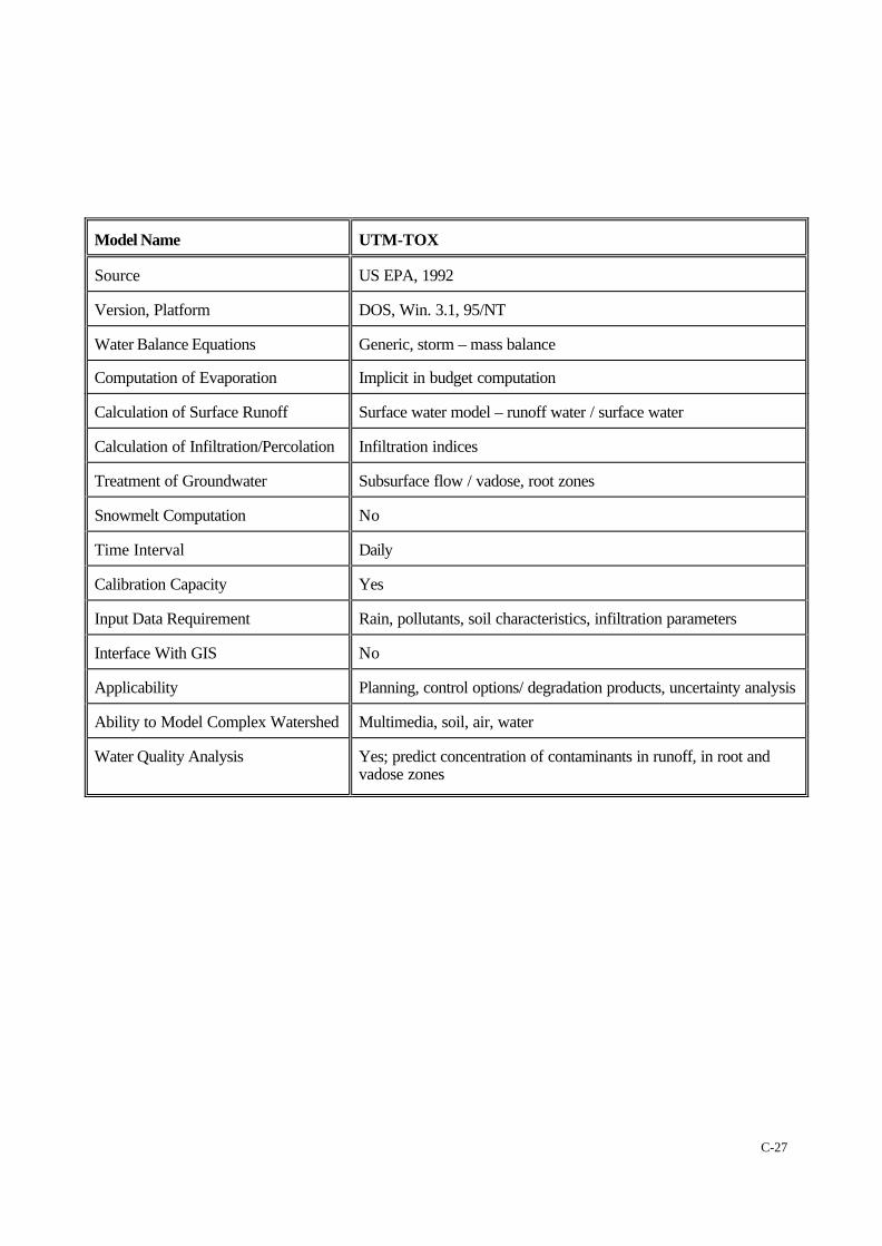
Model Name UTM-TOX
Source US EPA, 1992
Version, Platform DOS, Win. 3.1, 95/NT
Water Balance Equations Generic, storm – mass balance
Computation of Evaporation Implicit in budget computation
Calculation of Surface Runoff Surface water model – runoff water / surface water
Calculation of Infiltration/Percolation Infiltration indices
Treatment of Groundwater Subsurface flow / vadose, root zones
Snowmelt Computation No
Time Interval Daily
Calibration Capacity Yes
Input Data Requirement Rain, pollutants, soil characteristics, infiltration parameters
Interface With GIS No
Applicability Planning, control options/ degradation products, uncertainty analysis
Ability to Model Complex Watershed Multimedia, soil, air, water
Water Quality Analysis Yes; predict concentration of contaminants in runoff, in root andvadose zones

C-28
Model Name SWRBB
Source US EPA, 1992
Version, Platform DOS/MS, PC
Water Balance Equations Generic – mass balance nutrient / pesticides
Computation of Evaporation Implicit
Calculation of Surface Runoff Stormwater from agricultural watersheds / rainfall-runoff assessment
Calculation of Infiltration/Percolation Infiltration to soil / groundwater contamination
Treatment of Groundwater Interface with water movement in soil / groundwater contamination
Snowmelt Computation No
Time Interval Daily
Calibration Capacity Yes / SCS curve numbers
Input Data Requirement Rain, soil characteristics, evaporation
Interface With GIS Feasible
Applicability Watershed / water and sediment yield, return flow, pond andreservoir storage, sediment movement through ponds, flood routing
Ability to Model Complex Watershed Basin scale / large, complex and rural – water quality
Water Quality Analysis Yes; sediment components, nitrogen, phosphorous, pesticides

C-29
Model Name QHM
Source Scientific Software Group (SSG), 1997
Version, Platform DOS, Win. 3.1, 95/NT
Water Balance Equations Generic – water quantity / quality
Computation of Evaporation Implicit in budget computations
Calculation of Surface Runoff Surface runoff, winter flow, snowmelt, channel flow
Calculation of Infiltration/Percolation Infiltration indices / equations
Treatment of Groundwater Implicit – recharge / baseflow
Snowmelt Computation Yes
Time Interval Hourly / Daily
Calibration Capacity Yes / moderate – compare total flow and sediment load
Input Data Requirement Rain, temperature, soil, land use, BMPs
Interface With GIS Feasible
Applicability Watershed / analysis, sizing of stormwater BMPs, flow control andtreatment ponds
Ability to Model Complex Watershed To watershed processes / reservoirs, streams, control ponds, streambank erosion
Water Quality Analysis Yes; soil erosion, urban runoff pollutants

C-30
Model Name WMS
Source Scientific Software Group (SSG), 1997
Version, Platform DOS, Win. 3.1, 95/NT
Water Balance Equations Generic – a digital terrain analysis modelling application
Computation of Evaporation Implicit in budget computations
Calculation of Surface Runoff Incorporated in applied watershed model – Rational methods,TR-20, HEC-1
Calculation of Infiltration/Percolation Implicit – infiltration indices / equations
Treatment of Groundwater Implicit – baseflow estimations
Snowmelt Computation Feasible
Time Interval Hourly
Calibration Capacity Yes / moderate
Input Data Requirement Watershed / subwatershed boundaries, images
Interface With GIS Yes – integrated digital terrain analysis and hydrologic modelling
Applicability Planning, urban control options, geometric parameter descriptions,delineate watersheds, floodplain delineation
Ability to Model Complex Watershed Moderate
Water Quality Analysis Feasible

C-31
insert summary sheet here (SurfWatersummary.doc)
C-32
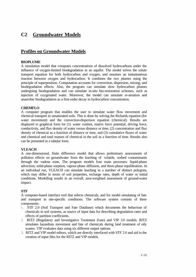
C2 Groundwater Models
Profiles on Groundwater Models
BIOPLUMEA simulation model that computes concentrations of dissolved hydrocarbons under theinfluence of oxygen-limited biodegradation in an aquifer. The model solves the solutetransport equation for both hydrocarbon and oxygen, and assumes an instantaneousreaction between oxygen and hydrocarbon. It combines the two plumes using theprinciple of superposition. Computation accounts for convection, dispersion, mixing, andbiodegradation effects. Also, the program can simulate slow hydrocarbon plumesundergoing biodegradation and can simulate in-situ bio-restoration schemes, such asinjection of oxygenated water. Moreover, the model can simulate re-aeration andanaerobic biodegradation as a first-order decay in hydrocarbon concentration.
CHEMFLOA computer program that enables the user to simulate water flow movement andchemical transport in unsaturated soils. This is done by solving the Richards equation (forwater movement) and the convection-dispersion equation (chemical). Results aredisplayed in graphical form for (1) water content, matrix force potential, driving force,conductivity, and flux density of water versus distance or time, (2) concentration and fluxdensity of chemical as a function of distance or time, and (3) cumulative fluxes of waterand chemical and total masses of chemical in the soil as a function of time. Results alsocan be presented in a tabular form.
VLEACHA one-dimensional, finite difference model that allows preliminary assessments ofpollution effects on groundwater from the leaching of volatile, sorbed contaminantsthrough the vadose zone. The program models four main processes: liquid-phaseadvection, solid-phase sorption, vapour-phase diffusion, and three-phase equilibration. Inan individual run, VLEACH can simulate leaching in a number of distinct polygons,which may differ in terms of soil properties, recharge rates, depth of water or initialconditions. Modelling results in an overall, area-weighted assessment of ground-waterimpact.
STFA computer-based interface tool that selects chemicals, and for model simulating of fateand transport in site-specific conditions. The software system consists of threecomponents:1. STF 2.0 (Soil Transport and Fate Database) which documents the behaviour of
chemicals in soil systems, as source of input data for describing degradation rates andeffects of partition coefficients.
2. RITZ (Regulatory and Investigative Treatment Zone) and VIP 3.0 models. RITZsimulates hazardous movement and fate of chemicals during land treatment of oilywastes. VIP evaluates data using six different output options.
3. RITZ and VIP model editors, which are directly interfaced with STF 2.0 and aid in thecreation of input files for the RITZ and VIP models.
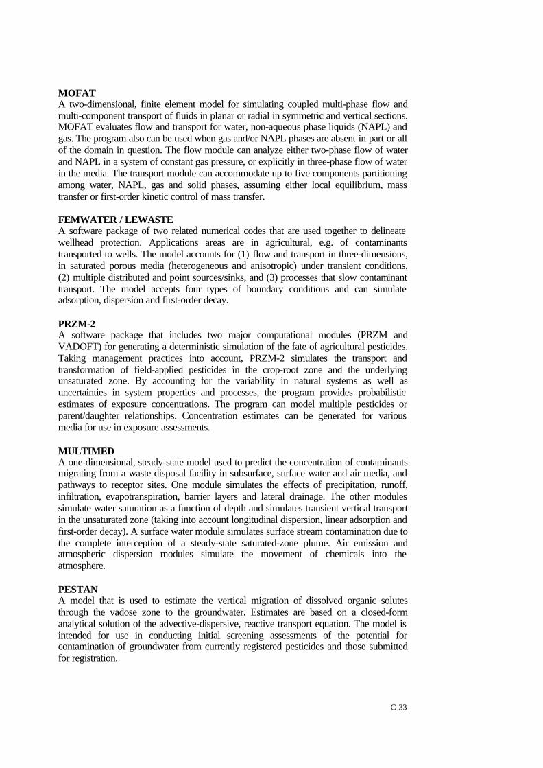
C-33
MOFATA two-dimensional, finite element model for simulating coupled multi-phase flow andmulti-component transport of fluids in planar or radial in symmetric and vertical sections.MOFAT evaluates flow and transport for water, non-aqueous phase liquids (NAPL) andgas. The program also can be used when gas and/or NAPL phases are absent in part or allof the domain in question. The flow module can analyze either two-phase flow of waterand NAPL in a system of constant gas pressure, or explicitly in three-phase flow of waterin the media. The transport module can accommodate up to five components partitioningamong water, NAPL, gas and solid phases, assuming either local equilibrium, masstransfer or first-order kinetic control of mass transfer.
FEMWATER / LEWASTEA software package of two related numerical codes that are used together to delineatewellhead protection. Applications areas are in agricultural, e.g. of contaminantstransported to wells. The model accounts for (1) flow and transport in three-dimensions,in saturated porous media (heterogeneous and anisotropic) under transient conditions,(2) multiple distributed and point sources/sinks, and (3) processes that slow contaminanttransport. The model accepts four types of boundary conditions and can simulateadsorption, dispersion and first-order decay.
PRZM-2A software package that includes two major computational modules (PRZM andVADOFT) for generating a deterministic simulation of the fate of agricultural pesticides.Taking management practices into account, PRZM-2 simulates the transport andtransformation of field-applied pesticides in the crop-root zone and the underlyingunsaturated zone. By accounting for the variability in natural systems as well asuncertainties in system properties and processes, the program provides probabilisticestimates of exposure concentrations. The program can model multiple pesticides orparent/daughter relationships. Concentration estimates can be generated for variousmedia for use in exposure assessments.
MULTIMEDA one-dimensional, steady-state model used to predict the concentration of contaminantsmigrating from a waste disposal facility in subsurface, surface water and air media, andpathways to receptor sites. One module simulates the effects of precipitation, runoff,infiltration, evapotranspiration, barrier layers and lateral drainage. The other modulessimulate water saturation as a function of depth and simulates transient vertical transportin the unsaturated zone (taking into account longitudinal dispersion, linear adsorption andfirst-order decay). A surface water module simulates surface stream contamination due tothe complete interception of a steady-state saturated-zone plume. Air emission andatmospheric dispersion modules simulate the movement of chemicals into theatmosphere.
PESTANA model that is used to estimate the vertical migration of dissolved organic solutesthrough the vadose zone to the groundwater. Estimates are based on a closed-formanalytical solution of the advective-dispersive, reactive transport equation. The model isintended for use in conducting initial screening assessments of the potential forcontamination of groundwater from currently registered pesticides and those submittedfor registration.

C-34
RETCA program developed to analyze hydraulic conductivity properties of unsaturated soils.The parametric models of Brooks-Corey and van Genuchten depict the soil waterretention curve, and the theoretical pore-size distribution models of Mualem and Burdinepredict the soil unsaturated hydraulic conductivity function. The simulation can begenerated from observed soil water retention data, on the assumption that one canobserve conductivity values (not necessarily at saturation). The program also permits theusers to fit analytical equations to observed water retention and hydraulic conductivitydata.
WHAEMA computer-based tool used in the wellhead protection decision-making process. It isable to delineate groundwater capture zones and isochrones of residence times. Unlike itsequivalent programs, WHAEM can accommodate fairly realistic boundary conditions,such as streams, lakes, and aquifer recharge due to precipitation. The software consistsof:1. GAEP (Geographic Analytic Element Preprocessor), which is used to simplify
preparation of input data.2. CZAEM (Capture Zone Analytic Element Model), which generates output on
groundwater capture zones and residence times. CZAEM accurately defines capturezone boundaries by first determining all stagnation points and dividing streamlines inthe flow domain.
WHPAA semi-analytical model for simulation groundwater flow. It is able to delineate thecapture zones in a wellhead protection area. The program consists of four computationalmodules (RESSQC, MWCAP, CPTRAC and MONTEC). WHPA is applicable tohomogenous aquifers exhibiting two-dimensional, steady groundwater flow in an arealplane, and is appropriate for evaluating multiple phase aquifer types (i.e. confined, leaky-confined and unconfined). The model is capable of simulating barrier or stream boundaryconditions that exist over the entire depth of the aquifer. WPHA can account for multiplepumping and injection wells and can quantitatively assess the effects of uncertain inputparameters on a delineated capture zone. The program can be used as a post-processor fortwo-dimensional numerical models of groundwater flow.
MODFLOWA three-dimensional groundwater flow model (McDonald and Harbaugh, 1988). Themodel solves the three-dimension flow equation for movement of flow through theaquifer, using a finite difference method. External stresses such as wells, areal recharge,evaporation, drains and streams can be simulated. The model accommodates steady statesolution, mass balance, leaky aquifers, and grid time stepping
MT3DA three-dimensional transport model for simulation of advection, dispersion andchemical reaction of dissolved substances in groundwater systems. The model is referredto as MT3D, and uses a modular structure similar to MODFLOW (USGS, 1998). This isthe modular three-dimensional finite difference groundwater flow model (McDonald,1984). The modular structure makes it possible to simulate advection, dispersion,sink/source mixing and chemical reactions independently without reserving computermemory space. New transport processes and options can be added to the model. Themodel accommodates the following spatial discretization capabilities and transport

C-35
boundary conditions, confined and unconfined aquifers, inclined model layers andvariable cell thickness within the same layers, specified concentration or mass fluxboundaries, and solute transport effects of external sources and sinks such as drains,wells, rivers, areal recharge, evaporation.
CZAEMA groundwater model for confined and unconfined flow in shallow aquifers. It isdesigned with an elementary capture zone analysis, based on an analytical elementmethod. Uses the Dupuit-Forcheimer assumptions in computation. It supports uniformflow, uniform infiltration over a circular area, wells and line sinks. The line sinks can beused to simulate streams and boundaries of rivers and lakes.
UNSODAIs a database for unsaturated and saturated soil hydraulic properties (water retention,hydraulic conductivity, soil diffusivity), basic soil properties (particle size distribution,bulk density, organic matter content), etc. The program can be used to store and edit data,search for data sets based on user-defined query questions, write the contents of selecteddata sets to an abrupt, describe the unsaturated hydraulic data with closed-form analyticalexpression. The unsaturated hydraulic conductivity functions are key input in numericalmodels of vadose zone process. UNSODA can be used as a repository of data sets thatcan be used as a source of surrogate hydraulic data or the development of an elevation ofindirect methods for estimating the unsaturated hydraulic properties.
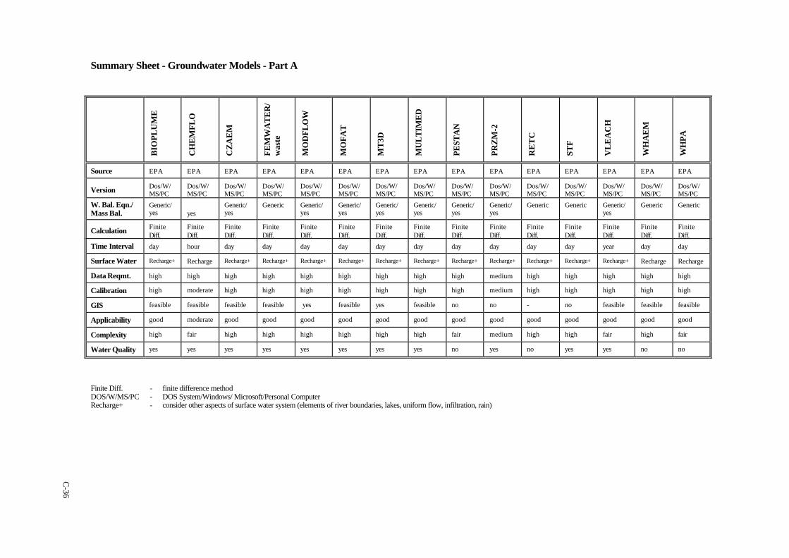
Summary Sheet - Groundwater Models - Part A
BIO
PLU
ME
CH
EM
FLO
CZ
AE
M
FEM
WA
TE
R/
was
te
MO
DFL
OW
MO
FAT
MT
3D
MU
LT
IME
D
PEST
AN
PRZ
M-2
RE
TC
STF
VL
EA
CH
WH
AE
M
WH
PA
Source EPA EPA EPA EPA EPA EPA EPA EPA EPA EPA EPA EPA EPA EPA EPA
Version Dos/W/MS/PC
Dos/W/MS/PC
Dos/W/MS/PC
Dos/W/MS/PC
Dos/W/MS/PC
Dos/W/MS/PC
Dos/W/MS/PC
Dos/W/MS/PC
Dos/W/MS/PC
Dos/W/MS/PC
Dos/W/MS/PC
Dos/W/MS/PC
Dos/W/MS/PC
Dos/W/MS/PC
Dos/W/MS/PC
W. Bal. Eqn./Mass Bal.
Generic/yes yes
Generic/yes
Generic Generic/yes
Generic/yes
Generic/yes
Generic/yes
Generic/yes
Generic/yes
Generic Generic Generic/yes
Generic Generic
Calculation FiniteDiff.
FiniteDiff.
FiniteDiff.
FiniteDiff.
FiniteDiff.
FiniteDiff.
FiniteDiff.
FiniteDiff.
FiniteDiff.
FiniteDiff.
FiniteDiff.
FiniteDiff.
FiniteDiff.
FiniteDiff.
FiniteDiff.
Time Interval day hour day day day day day day day day day day year day day
Surface Water Recharge+ Recharge Recharge+ Recharge+ Recharge+ Recharge+ Recharge+ Recharge+ Recharge+ Recharge+ Recharge+ Recharge+ Recharge+ Recharge Recharge
Data Reqmt. high high high high high high high high high medium high high high high high
Calibration high moderate high high high high high high high medium high high high high high
GIS feasible feasible feasible feasible yes feasible yes feasible no no - no feasible feasible feasible
Applicability good moderate good good good good good good good good good good good good good
Complexity high fair high high high high high high fair medium high high fair high fair
Water Quality yes yes yes yes yes yes yes yes no yes no yes yes no no
Finite Diff. - finite difference methodDOS/W/MS/PC - DOS System/Windows/ Microsoft/Personal ComputerRecharge+ - consider other aspects of surface water system (elements of river boundaries, lakes, uniform flow, infiltration, rain)
C-36
insert Summary Sheet - Part B here (GrndWatersummary.doc)
C-37