Embed Size (px)
Citation preview

Subaqueous Subaqueous SoilsSoils
““A New Frontier A New Frontier in Soil Surveyin Soil Survey””
By Jim TurenneBy Jim Turenne
http://http://nesoil.com.sasnesoil.com.sas
Subaqueous HistorySubaqueous History• Traditional soil survey
conducted on land. Not a lot of work in wetlands and tidal marshes until the 70’s.
• In 1993 – “Submerged Soils: A New Frontier in Soil Survey” by George Demas published in Soil Survey Horizons.
• Most work in Chesapeake Bay Region – Maryland/Delaware.
• George pioneered the concept of Subaqueous Soils differentiating them from sediment.
George DemasGeorge Demas

Is it Soil or Sediment?Is it Soil or Sediment?
Qualifying Criteria:Qualifying Criteria:1.1. Supplies Supplies
nutrients to nutrients to plantsplants
2.2. Forms Forms horizons in horizons in placeplace
Eel Grass
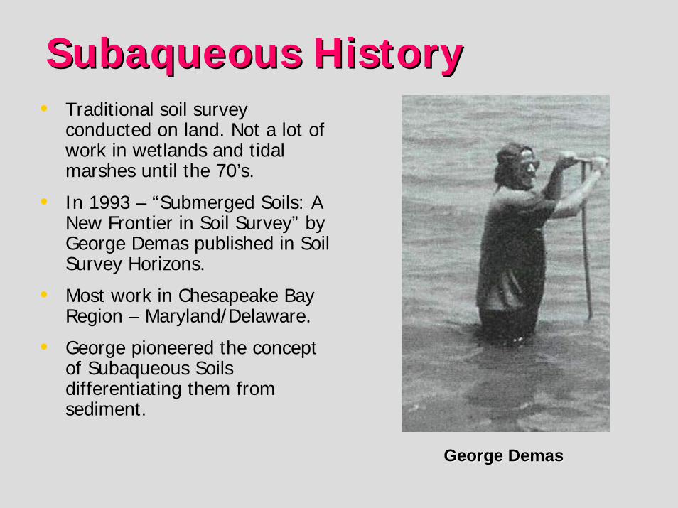
Definition of SoilDefinition of SoilSoil…is a natural body that
occurs on the land surface, …and is characterized by [either]
1. Horizons, or layers, that are distinguishable from the initial material as a result of additions, losses, transfers, and transformations of energy and matter or
2. The ability to support rooted plants in a natural environment.

Definition of SoilDefinition of Soil
The upper limit of soil is the boundary between The upper limit of soil is the boundary between soil and air [or] soil and air [or] shallow watershallow water……[not] too deep [not] too deep (typically more than 2.5 m*) for the growth of (typically more than 2.5 m*) for the growth of rooted plants.rooted plants.
Added to Soil Taxonomy in 1999 as a result of work in Added to Soil Taxonomy in 1999 as a result of work in Maryland/Delaware.Maryland/Delaware.
**Arbitrary depth set as a cutArbitrary depth set as a cut--off for soil survey.off for soil survey.
Cowardin Wetlands Classification
Factors of Subaqueous Soil Factors of Subaqueous Soil FormationFormationCombination of JennyCombination of Jenny’’s soil forming factors s soil forming factors
and and FolgerFolger’’ss sediment genesis factors:sediment genesis factors:Ss = Ss = f(Cf(C, O, B, F, P, T, W, CE), O, B, F, P, T, W, CE)Ss = subaqueous soilSs = subaqueous soil
C = Climate/temp. T = TimeO = Organisms W = Water column attributesB = Bathymetry CE = Catastrophic eventsF = Flow Regime Demas, Rabenhorst. 2001Factors Demas, Rabenhorst. 2001Factors
ofofP = Parent Material Subaqueous Soil Formation.Subaqueous Soil Formation.
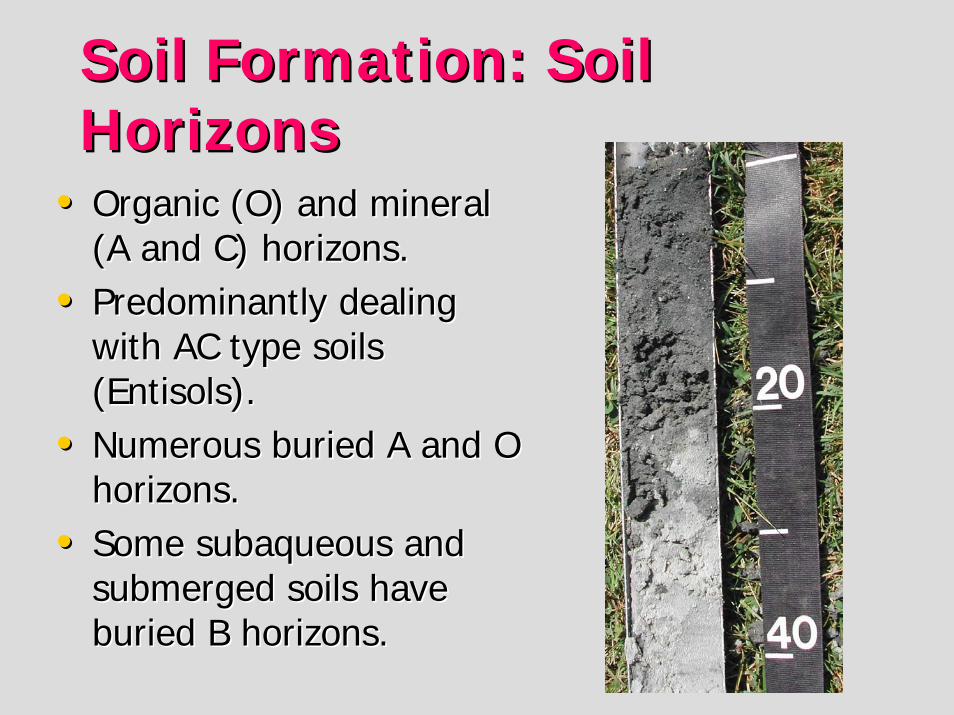
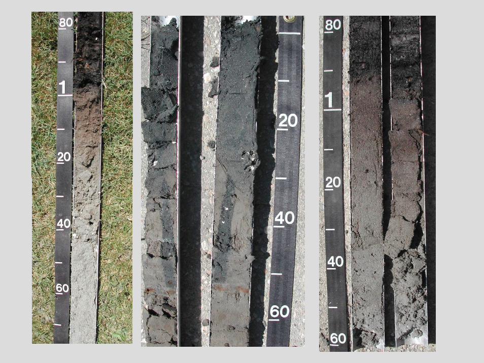
Soil Formation: Soil Soil Formation: Soil HorizonsHorizons
•• Organic (O) and mineral Organic (O) and mineral (A and C) horizons.(A and C) horizons.
•• Predominantly dealing Predominantly dealing with AC type soils with AC type soils (Entisols).(Entisols).
•• Numerous buried A and O Numerous buried A and O horizons.horizons.
•• Some subaqueous and Some subaqueous and submerged soils have submerged soils have buried B horizons.buried B horizons.
Soil Formation: Soil Formation: Additions/Losses/TransfersAdditions/Losses/Transfers
AdditionsAdditions•• Additions of mineral Additions of mineral
sediments sediments –– alluvial alluvial deposits.deposits.
•• Biological additions Biological additions ––shells, organisms.shells, organisms.
•• Anthropogenic additions Anthropogenic additions ––dredge material, dredge material, mechanical disturbance.mechanical disturbance.
LossesLosses•• Erosion losses Erosion losses –– wave wave
and storm losses, tidal and storm losses, tidal currents.currents.
•• Decomposition of organic Decomposition of organic matter.matter.
TransfersTransfers•• Diffusion Diffusion –– hi to low hi to low
concentrations.concentrations.•• BioturbationBioturbation..
Bottom Line: Shallow Water Environments can best be studied as SOIL!
Significance and Value ofSignificance and Value ofSubaqueous Soil InventorySubaqueous Soil Inventory•• Sediment characteristics presented to a Sediment characteristics presented to a
greater depth (2 m), rather than a greater depth (2 m), rather than a ““surficialsurficial”” approach.approach.
•• Provides a comprehensive classification Provides a comprehensive classification scheme (Soil Taxonomy, SSM) for shallow scheme (Soil Taxonomy, SSM) for shallow water sediments.water sediments.
•• Could provide a major or missing data set Could provide a major or missing data set for SAV restoration, estuarine protection, for SAV restoration, estuarine protection, planning and management.planning and management.
•• NRCS responsibility to inventory soils.NRCS responsibility to inventory soils.
Specific Soil Based InterpretationsSpecific Soil Based Interpretations• SAV Restoration• Crab Habitat• Clam Stocking• Management for Sustainable Shellfish Production• Nutrient Reduction• Pathogens Pfesteria Cyst Residence Sites • Benthic Preservation Site Identification• Wildlife Management • Wading Shore Birds, Migratory Waterfowl, Nurseries and Spawning Areas• Habitat Protection for Horseshoe Crab and Diamondback Terrapin• Dredging Island Creation• Tidal Marsh Protection and Creation• Bathymetric Map• Navigational Channel Creation/Maintenance• Effects of Dredging on Benthic Ecology• Off Site Disposal of Dredge Spoil• Acid-Sulfate Weathering Hazards• Dune and Beach Maintenance/Replenishment• Carbon Sequestration
Users of Subaqueous soil Users of Subaqueous soil survey data for specific survey data for specific resource Managementresource Management (Phil King – Delaware NRCS).
• Resource Managers• US-EPA, MD-DNR, MDE• Chesapeake Bay Program• DE Inland Bay Program• Maryland Coastal Bays Program• Egg Harbor, NJ• Baltimore Harbor/Bay Dredging
US-ACE• US-ACE, US-DI• Pamlico-Albermarle Sound NEP
Program
•• NOAA• US-ACE, MD-DNR, Wor SWCD,• DI Assateague Island National
Park• Private Aquaculture Industry• Shellfish Harvest Industry• NRCS, RCD, DE CIB, DNREC• DE Sierra Club• DNREC
Subaqueous Mapping Subaqueous Mapping ProcedureProcedure•• Need to develop a bathymetric map which Need to develop a bathymetric map which
is used for subaqueous landform is used for subaqueous landform identification. identification.
•• Can use existing NOAA charts (order 3 Can use existing NOAA charts (order 3 mapping) or create detailed bathymetry mapping) or create detailed bathymetry using fathometer and survey equipment.using fathometer and survey equipment.
•• Remote sensing including LIDAR, Side Remote sensing including LIDAR, Side Scan Sonar, GPR (freshwater only), RTK Scan Sonar, GPR (freshwater only), RTK GPS.GPS.

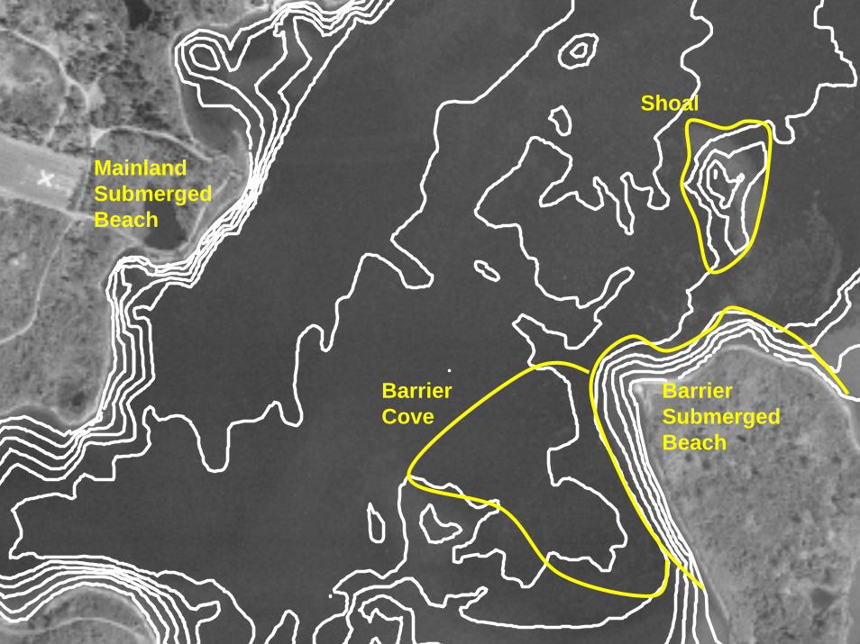
Barrier Cove
Barrier Submerged Beach
Shoal
Mainland Submerged Beach
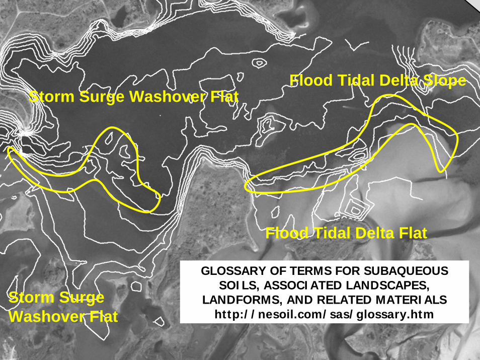
Flood Tidal Delta Flat
Flood Tidal Delta Slope
Storm Surge Washover Flat
Storm Surge Washover Flat
GLOSSARY OF TERMS FOR SUBAQUEOUS SOILS, ASSOCIATED LANDSCAPES,
LANDFORMS, AND RELATED MATERIALShttp://nesoil.com/sas/glossary.htm

Subaqueous Soil Mapping Subaqueous Soil Mapping ProcedureProcedure•• Develop subaqueous soil series and Develop subaqueous soil series and map unit map unit
Legend.Legend.•• Identify and delineate landforms to determine Identify and delineate landforms to determine
soil map unit breaks.soil map unit breaks.•• Map the area using standard NCSS procedure. Map the area using standard NCSS procedure.
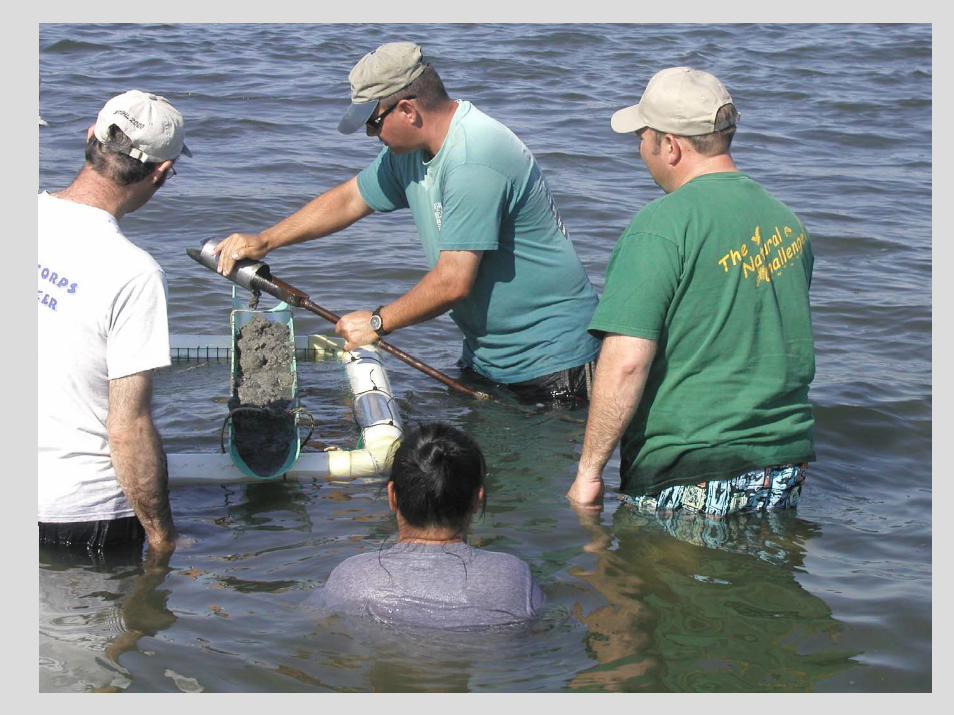
Bucket augers and McCauley peat corers are Bucket augers and McCauley peat corers are used to investigate morphology.used to investigate morphology.
•• Vibracore techniques are used for deep and Vibracore techniques are used for deep and detailed observations.detailed observations.
•• Determine map unit composition, inclusions, Determine map unit composition, inclusions, ROC, and other information ROC, and other information –– compile map.compile map.
Problems/ConsiderationsProblems/Considerations•• Difficult mapping conditions and procedure Difficult mapping conditions and procedure
((augeringaugering in water, describing profiles, etc.). in water, describing profiles, etc.). •• Need interNeed inter--discipline collaboration (coastal discipline collaboration (coastal
geology, marine ecology, biologist, etc.).geology, marine ecology, biologist, etc.).•• Alluvial soils are very variable and subject to Alluvial soils are very variable and subject to
change (seasonal and long term).change (seasonal and long term).•• Seasonal mapping (bathymetry year round).Seasonal mapping (bathymetry year round).•• Safety concerns (weather, boating, Safety concerns (weather, boating,
environmental).environmental).•• Requires some additional equipment, storage Requires some additional equipment, storage
space, and maintenancespace, and maintenance. .
Final ProductFinal ProductSoil Survey of Coastal, Subaqueous and Soil Survey of Coastal, Subaqueous and
Submerged Soils of MLRASubmerged Soils of MLRA’’s 144A, s 144A, 149B149B……(MO(MO--12)12)
Maps showing the spatial distribution.Maps showing the spatial distribution.Manuscript:Manuscript:1.1. Description of the soils.Description of the soils.2.2. Formation, genesis, classification.Formation, genesis, classification.3.3. Use, interpretations, and management Use, interpretations, and management ––
ecological, fisheries, SAV, engineering, hazards, ecological, fisheries, SAV, engineering, hazards, etc.etc.
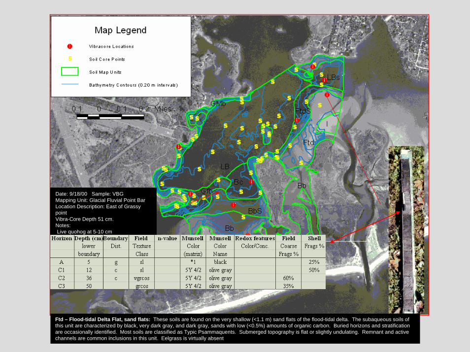
Ftd – Flood-tidal Delta Flat, sand flats: These soils are found on the very shallow (<1.1 m) sand flats of the flood-tidal delta. The subaqueous soils of this unit are characterized by black, very dark gray, and dark gray, sands with low (<0.5%) amounts of organic carbon. Buried horizons and stratification are occasionally identified. Most soils are classified as Typic Psammaquents. Submerged topography is flat or slightly undulating. Remnant and active channels are common inclusions in this unit. Eelgrass is virtually absent
Date: 9/18/00 Sample: VBGMapping Unit: Glacial Fluvial Point BarLocation Description: East of Grassy pointVibra-Core Depth 51 cm. Notes:Live quohog at 5-10 cm.
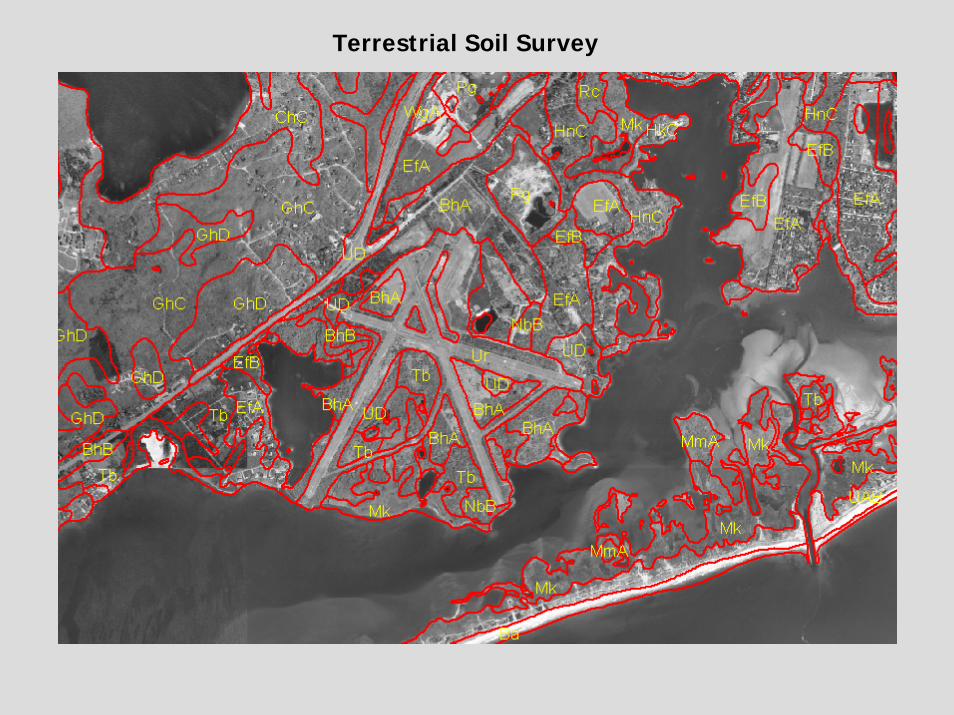
Terrestrial Soil Survey
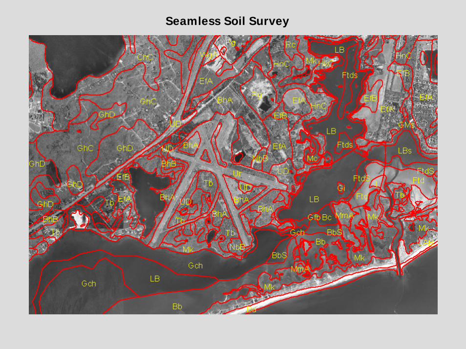
Seamless Soil Survey

VibracoreVibracoreBathymetry

Hand ToolsHand Tools

ENDEND
Visit: www.mapcoast.org for more information