Embed Size (px)
Citation preview

Development of Standard Terminology and Taxa for
Subaqueous Soils
Mark H. StoltNatural Resources ScienceUniversity of Rhode Island
Martin C. RabenhorstEnvironmental Science and Technology
University of Maryland

Why was there a need?
Subaqueous soils have a combination of properties and characteristics not typically found in most subariel soils.

Why was there a need?
Soil Taxonomy classes did not fully apply to the range and characteristics of subaqueous soils important for interpretations

Why was there a need?
No standard set of terms for landforms and parent materials.
Identification and delineation of landforms are the first step in development of the soil survey


Subaqueous Soil Investigations
Maine
MassachusettsNew Hampshire
Rhode Island
Connecticut
New York
Delaware
Maryland
FloridaTexas


Incorporated into the National Soil Survey Handbook (2007?)

Amendments to Soil TaxonomyGeorge Demas originally proposed “subaquic” subgroups. For example, “Subaquic Fluvaquents”
At the 2002 NENCSS meeting in NY folks agreed that this was acceptable but there may be a better approach;
Most argued that the difference between subaerial Aquents and subaqueous Aquents was too big to separate at the subgroup level; some wanted a new order.
Final consensus was to make the distinction at the suborder level where most moisture regime breaks are applied.
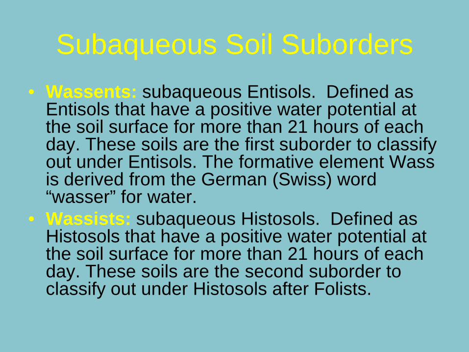
Subaqueous Soil Suborders• Wassents: subaqueous Entisols. Defined as
Entisols that have a positive water potential at the soil surface for more than 21 hours of each day. These soils are the first suborder to classify out under Entisols. The formative element Wassis derived from the German (Swiss) word “wasser” for water.
• Wassists: subaqueous Histosols. Defined as Histosols that have a positive water potential at the soil surface for more than 21 hours of each day. These soils are the second suborder to classify out under Histosols after Folists.

Wassent Great Groups• Frasiwassents: Wassents that have, in all horizons within 100 cm
of the mineral soil surface, an electrical conductivity of <0.2 dS/m in a 5/1 by volume mixture of water and soil.
• Psammowassents: Wassents that have less than 35 percent (by volume) rock fragments and a texture of loamy fine sand or coarser in all layers within the particle-size control section.
• Sulfiwassents: Wassents that have a horizon or horizons with a combined thickness of at least 15 cm within 50 cm of the mineral soil surface that contain sulfidic materials.
• Hydrowassents: Wassents that have, in all horizons at a depth between 20 and 50 cm below the mineral soil surface, both an n value of more than 0.7 and 8 percent or more clay in the fine earth fraction.
• Fluviwassents: Wassents that have either 0.2 percent or more organic carbon of Holocene age at a depth of 125 cm below the mineral soil surface; or an irregular decrease in content of organic carbon from a depth of 25 cm to a depth of 125 cm or to a densic, lithic, or paralithic contact if shallower.
• Haplowassents: Other Wassents.
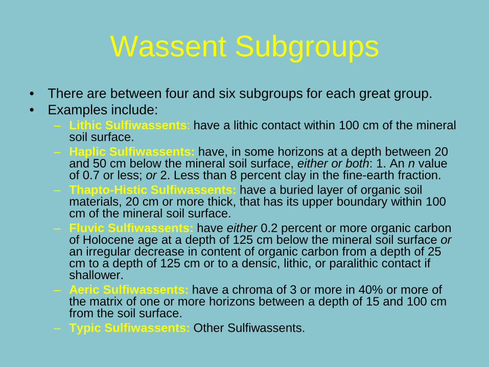
Wassent Subgroups• There are between four and six subgroups for each great group.• Examples include:
– Lithic Sulfiwassents: have a lithic contact within 100 cm of the mineral soil surface.
– Haplic Sulfiwassents: have, in some horizons at a depth between 20 and 50 cm below the mineral soil surface, either or both: 1. An n value of 0.7 or less; or 2. Less than 8 percent clay in the fine-earth fraction.
– Thapto-Histic Sulfiwassents: have a buried layer of organic soil materials, 20 cm or more thick, that has its upper boundary within 100 cm of the mineral soil surface.
– Fluvic Sulfiwassents: have either 0.2 percent or more organic carbon of Holocene age at a depth of 125 cm below the mineral soil surface or an irregular decrease in content of organic carbon from a depth of 25 cm to a depth of 125 cm or to a densic, lithic, or paralithic contact if shallower.
– Aeric Sulfiwassents: have a chroma of 3 or more in 40% or more of the matrix of one or more horizons between a depth of 15 and 100 cm from the soil surface.
– Typic Sulfiwassents: Other Sulfiwassents.

Wassist Great Groups
• Frasiwassists: Wassists that have, in all horizons within 100 cm of the mineral soil surface, an electrical conductivity of <0.2 dS/m in a 5/1 by volume mixture of water and soil.
• Sulfiwassists: Wassists that have sulfidicmaterials within 50 cm of the mineral soil surface.
• Haplowassists: Other Wassists.

Wassist SubgroupsThere are three subgroups for each Wassist Great Group.
– Fibric subgroups: have more thickness of fibric soil materials than any other kind of organic soil material either: 1. In the organic parts of the subsurface tier if there is no continuous mineral layer 40 cm or more thick that has its upper boundary within the subsurface tier; or 2. In the combined thickness of the organic parts of the surface and subsurface tiers if there is a continuous mineral layer 40 cm or more thick that has its upper boundary within the subsurface tier;
– Sapric subgroups: have more thickness of sapric soil materials than any other kind of organic soil materials either: 1. In the organic parts of the subsurface tier if there is no continuous mineral layer 40 cm or more thick that has its upper boundary within the subsurface tier; or 2. In the combined thickness of the organic parts of the surface and subsurface tiers if there is a continuous mineral layer 40 cm or more thick that has its upper boundary within the subsurface tier.
– Typic subgroups: others Wassist subgroups.

Wassepts(not proposed but observed)
Great Groups• AA. Wassepts that have, in all horizons within 100 cm of the mineral
soil surface, an electrical conductivity of <0.2 dS/m in a 5/1 by volume mixture (not extract) of water and soil. Frasiwassepts
• AB. Other Wassents that have a horizon or horizons with a combined thickness of at least 15 cm within 50 cm of the mineral soil surface that contain sulfidic materials. Sulfiwassepts
• AC. Other Wassents that have either 0.2 percent or more organic carbon of Holocene age at a depth of 125 cm below the mineral soil surface or an irregular decrease in content of organic carbon from a depth of 25 cm to a depth of 125 cm or to a densic, lithic, or paralithic contact if shallower. Fluviwassepts
• AD. Other Wassents. Haplowassepts

LB
Bb
Ftd
Bc
BbS
FtdS
Mbe
Msc
Mc
Mch
Bbe
McSh
SI
Mbe
SI
Mbe
Mc
#
#
#
#
#
#
-0.6-0.9
-1.2
-1.5-1.8
-2.1
-0.3-0.6Marshneck Point
Grassy Point

LB
Bb
Ftd
Bc
BbS
FtdS
Mbe
Msc
Mc
Mch
Bbe
McSh
SI
Mbe
SI
Mbe
Mc
#
#
#
#
#
#
-0.6-0.9
-1.2
-1.5-1.8
-2.1
-0.3-0.6Marshneck Point
Grassy Point


Washover Fan Flat
Flood-Tidal Delta
Typic Psammowassent

Flood-Tidal Delta Slope
Sulfic Fluviwassent

Mainland Cove
Sapric Sulfiwassist

Mainland Submerged Beach
Aeric Haplowassent

Sapric Frasiwassist

Histic Fluvawassept

LOCATION PISHAGQUA RITentative SeriesJDT, MPB, MS03/2007
PISHAGQUA SERIESThe Pishagqua series consists of very deep, subaquic soils that are permanently submerged in low energy depositional basins, estuaries and coastal lagoons. The Pishagqua soils formed in silty estuarine deposits. Estimated saturated hydraulic conductivity is moderately high to high. Slopes range from 0 to 3 percent, mean annual air temperature is 10 degrees C, and mean annual precipitation is 1320 mm.TAXONOMIC CLASS: Fine-silty, mixed, superactive, nonacid, mesic Typic Sulfiwassents
TYPICAL PEDON: Pishagqua silt loam on a south facing 1 percent, concave slope in an Eelgrass (Zostera marina) bed of a lagoon bottom channel under 2 meters (National Vertical Datum 1988) of estuarine water. Tidal range is 24 cm. (Colors are for moist soil unless otherwise noted). Ag--0 to 15 cm; black (5Y 2.5/2), silt loam, gray (5Y 6/1) dry; massive; loose, nonsticky, nonplastic, very fluid; 1 percent flat angular shell fragments; hydrogen sulfide odor; strongly saline; slightly alkaline (pH 7.5); extremely acid (pH 3.9) after 8 weeks of aerobic incubation; clear boundary. (0 to 38 cm thick). Cg1--15 to 110 cm; black (5Y 2.5/1) silt loam; gray (5Y 5/1) dry; massive; loose, nonsticky, nonplastic, very fluid; 1 percent flat angular fine and medium shell fragments; hydrogen sulfide odor; strongly saline ;neutral (pH 7.0); extremely acid (pH 3.7) after 8 weeks of aerobic incubation; gradual boundary. Cg2--110 to 160 cm; black (5Y 2.5/1) silt loam, gray (5Y 6/1) dry; massive; loose, nonsticky, nonplastic, moderately fluid; hydrogen sulfide odor; neutral (pH 6.8); strongly saline; ultra acid (pH 3.3) after 8 weeks of aerobic incubation; gradual boundary. Cg3--160 to 200 cm; black (5Y 2.5/1) silt loam, gray (5Y 6/1) dry; massive; loose, nonsticky, nonplastic, moderately fluid; 1 percent flat subangular shell fragments; hydrogen sulfide odor; moderately saline; neutral (pH 6.7); ultra acid (pH 3.4) after 8 weeks of aerobic incubation; . TYPE LOCATION: Washington County, Rhode Island; Town of Charlestown, Fort Neck Cove of Ninigret Pond, about 1,360 feet north of the western tip of Potato Point and 1,260 feet south-west of the eastern-most shoreline position of Tautog Cove, Carolina USGS Quadrangle; lat. 41 degrees 22 minutes 33.77 seconds N. and long. 71 degrees 38 minutes 48.47 seconds W. NAD 83.
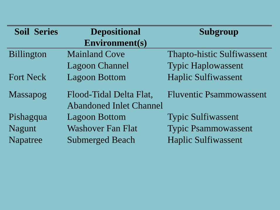
Soil Series Depositional Environment(s)
Subgroup
Billington Mainland Cove Thapto-histic SulfiwassentLagoon Channel Typic Haplowassent
Fort Neck Lagoon Bottom Haplic Sulfiwassent
Massapog Flood-Tidal Delta Flat, Abandoned Inlet Channel
Fluventic Psammowassent
Pishagqua Lagoon Bottom Typic SulfiwassentNagunt Washover Fan Flat Typic PsammowassentNapatree Submerged Beach Haplic Sulfiwassent

0
5
10
15
20
25
30
July
16 20
08
Augus
t 15 2
008
Septe
mber 1
4 200
8
Octobe
r 14 2
008
Novem
ber 1
3 200
8
Decem
ber 1
3 200
8
Janu
ary 12
2009
Febr
uary
11 20
09
Marc
h 13 2
009
April
12 20
09
May
12 20
09
June
11 20
09
ºC
Lagoon Bottom Washover Fan
Water temperature fluctuations in Quonochontaug Pond. Water temperature fluxes decreased with increasing water depth as can be seen between Washover Fan (0.8 meters deep) and Lagoon Bottom (3.2 meters deep).
Salisbury, 2010
0
5
10
15
20
25
30
Septem
ber 2
0 200
8
Octobe
r 20 2
008
Novem
ber 1
9 200
8
Decembe
r 19 2
008
Janua
ry 18
2009
Februa
ry 17
2009
March 1
9 200
9
April 1
8 200
9
May 18
2009
June 1
7 200
9
July 1
7 200
9
August
16 20
09
ºC
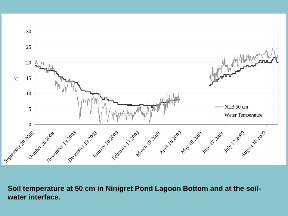
NLB 50 cmWater Temperature
Soil temperature at 50 cm in Ninigret Pond Lagoon Bottom and at the soil-water interface.

0
5
10
15
20
25
30
Septe
mber 2
0 200
8
Octobe
r 20 2
008
Novem
ber 1
9 200
8
Decembe
r 19 2
008
Janua
ry 18
2009
Febru
ary 17
2009
March 1
9 200
9
April 1
8 200
9
May 18
2009
June 1
7 200
9
July 1
7 200
9
August
16 20
09
ºC
NLB 25 cm
NWF 25 cm
Soil temperatures at 25 cm in Ninigret Pond Lagoon Bottom and Washover Fan . Both sites have the same water depths (1.00; 1.04 m). The coarser textured soil (NWF) has higher summer temperatures and lower winter temperatures suggesting a texture effect on soil temperature.

Soil Temperatures (ºC)
Site (iButton depth) Annual Summer Winter Summer - Winter Water Depth (m)
NWF (25 cm) 12.3 22.3 3.5 18.8 1.04
NWF (50 cm) 12.3 20.5 4.9 15.6 "
NLB (25 cm) 12.5 19.8 6.3 13.5 1.00
NLB (50 cm) 12.6 17.9 7.6 10.3 1.50
QWF (25 cm) 12.1 21.6 3.5 18.3 0.79
QSMB (25 cm) 12.1 20.7 4.7 16.0 0.99
QLB (25 cm) 10.8 16.9 5.6 11.4 3.19
Pawcatuck (40 cm) 8.7 16.8 4.5 12.3 -
Water Temperatures (ºC)
NWF 11.5 23.0 2.2 19.7 1.04
NLB 12.0 22.3 2.8 19.5 1.00
QWF 12.1 22.0 3.5 18.5 0.79
QSMB 12.4 21.8 4.3 17.5 0.99
QLB 11.2 19.5 4.2 15.3 3.19
Subaqueous soil and water temperatures means for September 20, 2008 – August 27, 2009. Data were collected every 4 hours.

Soil Temperature Summary
• Differences in subaqueous soil temperature among soil-landscape units controlled by:– Overlying water column temperature– Water column depth– Soil texture (especially at 25 cm)– Other factors? Tidal range, vegetation, distance to inlet
• Subaqueous soil temperature in Rhode Island– Mesic temperature regime – Subaqueous soil temperature warmer in winter, cooler in summer with
respect to water column temperature


![Phylogeny [phylo = tribe, family; gen = creation, birth] taxonomy: classifying and naming organisms taxon, taxa (pl.): classification unit (e.g. genus,](https://img.pdfslide.us/doc/110x75/56649d0b5503460f949defc7/phylogeny-phylo-tribe-family-gen-creation-birth-taxonomy-classifying.jpg)