Embed Size (px)
Citation preview

STORM WATER POLLUTION AND PREVENTION PLAN
PREPARED FOR:
CHEMFAX, INC. GULPORT, HARRISON COUNTY, MISSISSIPPI
PREPARED BY: EARTHCON CONSULTANTS, INC.
900 HOLCOMB BOULEVARD SUITE B
OCEAN SPRINGS, MISSISSIPPI 228-872-3097
EARTHCON PROJECT NO. 02.20130380.13
DECEMBER 20, 2013 REVISED JANUARY 13, 2014
Storm Water Pollution Prevention Plan i January 2013 Chemfax, Inc. Site Gulfport, Harrison County, Mississippi
TABLE OF CONTENTS Page
1.0 INTRODUCTION ................................................................................................................1
2.0 GENERAL SITE AND PROJECT DESCRIPTION..............................................................2
2.1 Description of the Nature of the Construction Activity, Potential Pollutants Sources .................................................................................................................2
2.2 Pollution Prevention Team Roles and Responsibilities .....................................5
2.3 Construction Schedule .........................................................................................6
2.4 Description of Disturbed Acreage .......................................................................6
2.5 Data Describing the Soil and Quality of Discharge from the Site ......................7
3.0 BEST MANAGEMENT PRACTICES TO MINIMIZE POLLUTION IN RUNOFF .................8
3.1 Erosion and Sediment Controls ...........................................................................8
3.2 Stabilization Practices ..........................................................................................9
3.3 Structural Control Practices............................................................................... 10
3.4 Permanent Storm Water Controls ...................................................................... 10
3.5 Other Controls .................................................................................................... 10
3.6 Maintenance ........................................................................................................ 10
3.7 Inspections of Controls ...................................................................................... 10
3.8 Threatened and Endangered Species ............................................................... 12
3.9 Registered Historic Places ................................................................................. 12
4.0 PROJECT COMPLETION REPORT AND RETENTION OF RECORDS .......................... 13
FIGURES Figure 1 Site Location Map Figure 2 Site Plan Figure 3 Surveyor's Map APPENDICES
Appendix A Large Construction Storm Water General Permit – NPDES Permit MSR10

Storm Water Pollution Prevention Plan ii January 2013 Chemfax, Inc. Site Gulfport, Harrison County, Mississippi
TABLE OF CONTENTS (continued) Appendix B Worksheets Worksheet #1 Pollution Prevention Team Member Roster Worksheet #2 Non-Storm Water Discharge Inspection Worksheet #3a Eligible Non-Storm Water Discharge Inspection Worksheet #3b Eligible Non-Storm Water Discharge Assessment
Worksheet #4 Non-Storm Water Discharge Assessment and Failure to Certify Notification
Worksheet #5 Material Inventory Worksheet #6 Description of Exposed Significant Material Worksheet #7 Risk Identification and Potential Pollutant Sources Narrative Worksheet #8 SWPPP Site Map Worksheet #9 List of Significant Spills and Leaks Worksheet #10 BMP Identification Worksheet #11 Employee Training Worksheet #12 SWPPP Weekly Site Inspection Checklist Worksheet #13 Weekly Visual Storm Water Discharge Analysis Worksheet 14 Quarterly Visual Storm Water Discharge Analysis
Appendix C Project Completion Report Appendix D SWPPP Certification
Storm Water Pollution Prevention Plan 1 January 2013 Chemfax, Inc. Site Gulfport, Harrison County, Mississippi
1.0 INTRODUCTION
A Storm Water Pollution Prevention Plan (SWPPP) must be prepared for storm water
discharges from construction activities that will potentially impact waters of the United States.
The SWPPP is designed to identify and address potential sources of pollution that are
reasonably expected to affect the quality of discharges from the construction site, including on-
site material storage areas, overburden and stockpiles of soil, borrow areas, equipment staging
areas, vehicle repair areas, and fueling areas used by owners or operators of the permitted
project. The SWPPP must describe the implementation of pollution prevention practices and
ensure that they will effectively reduce or eliminate the pollutants entering storm water
discharges associated with construction activity. The SWPPP also serves as a useful tool to
ensure compliance with the terms and conditions of MDEQ Large Construction Storm Water
General Permit – NPDES Permit MSR10 (Appendix A) relating to discharges of storm water
from large construction activities. The permit authorizes discharges of storm water from
construction activities as defined in WPC-1. To keep the SWPPP up to date and ensure proper
modifications of the plan are performed as required by the permit, worksheets in Appendix B
are provided. The worksheets will be completed and become part of the plan as modifications
to the plan or construction activity occur.
As required at sites where the total area of soil disturbance (excavation area, soil stockpile area
and equipment staging area) is greater than or equal to five acres, a large construction SWPPP
to seek coverage under the storm water general permit has been developed for the site prior to
commencement of planned activities. The SWPPP will be implemented for the duration of the
project and this document will be maintained on site.
Storm Water Pollution Prevention Plan 2 January 2013 Chemfax, Inc. Site Gulfport, Harrison County, Mississippi
2.0 GENERAL SITE AND PROJECT DESCRIPTION
The Chemfax, Inc. Site (“Site”) is located in Gulfport, Harrison County, Mississippi, and is
situated on 11 acres of land located to the east of Three Rivers Road. Creosote Road is to the
South, U.S. Highway 49 is to the west, and County Barn Road is to the north (Figures 1 and 2).
The Area of Interest (AOI) is limited to approximately 5 acres in the central portion of the Site
that was the location of previous Site activities and current contamination. The Site has
approximate coordinates of Latitude 30° 25’ 45’’ North, Longitude 89° 05’ 21’’ West. The
concrete slab of the former abandoned Alpine Masonite facility is also situated on the Site.
2.1 Description of the Nature of the Construction Activity, Potential Pollutants Sources
The basic construction activities described in this SWPPP are as follows:
• Site preparation activities, including demarcation of AOI and work areas, improvements to roads and implementation of storm water pollution controls.
• Concrete slab removal.
• Soil segregation and stockpiling, waste transportation and disposal.
• Soil excavation and backfilling activities.
• Post-removal activities, including metes-and-bounds surveys, and Site cleanup and restoration.
Potential pollutants from construction activities include incidental oil leaks from equipment
operation, maintenance and fueling; sediment loading from surface scarification; storm water
run-off from soil stockpiles; and tracking of sediments from equipment leaving the site that
eventually enter storm water run-off. Some construction materials, concrete debris,
contaminated soil, and backfill soil may be stockpiled on-site. Soil stockpiles will be removed by
the end of each work day to the extent practical. Any additional materials such as fuel,
lubricants, portable tanks, cement, or other potential pollutant source not mentioned herein will
be listed on the worksheets included in Appendix B.
Equipment maintenance may be performed on-site. If equipment maintenance is performed,
fluids will be drained into appropriate containers and disposed of properly offsite or re-used if
possible.

Storm Water Pollution Prevention Plan 3 January 2013 Chemfax, Inc. Site Gulfport, Harrison County, Mississippi
The Site will be segregated into two sections (north and south of a newly constructed temporary
haul road) and each section will be separated into appropriate work zones (exclusion,
contamination reduction, and support) by means of temporary construction fencing and/or
barrier tape. Soil excavation (and backfilling with clean soil) at the AOI will be conducted to a
maximum depth of six (6) feet below ground surface (bgs) in order to remove contaminated
soils. It is anticipated that all stockpiles will be located over areas planned for eventual
excavation. Sidewalls of the excavations will be sloped at an angle (1:1 to 3:1, depending upon
the geotechnical soil properties) sufficient to provide stability. Bracing using sheet pile retaining
walls or other means is not anticipated. However, additional soil stabilization measures will be
implemented when Site activities have ceased on any portion of the Site and will not be
resumed for fourteen (14) days or more. These additional measures will be implemented within
seven (7) calender days of when Site activities ceased.
It is anticipated that 14,900 cubic yards of soil will be removed from the Site. No phasing of the
excavation areas will occur, as work will be continuous. The excavated material will be staged
within the boundaries of the AOI. Following excavation, the area will be sampled and analyzed
before being backfilled with clean fill in lifts no greater than 12 inches per lift.
Soil excavation will be completed to depths of 0-1 feet, 0-3 feet, and 0-6 feet depending on the
extent of contamination. Excavation in the one (1) foot areas will be completed first, followed by
excavation of the three (3) foot and then six (6) foot areas. Demarcation of the excavation areas
can be seen in Figure 2.
Drainage will be designed for the Site and constructed as necessary, however the excavation
area is topographically higher than the surrounding areas therefore a natural berm will exist to
prevent stormwater runon. All storm water runoff affected by the excavation work should be
contained within the excavation areas.
Backfilled areas will be restored to natural grade upon completion of soil remediation activities.
A six (6) inch layer of topsoil, capable of sustaining vegetative growth, will be placed over the
backfilled areas. The topsoil will then be seeded with grass, covered with mulch and watered
to promote growth.

Storm Water Pollution Prevention Plan 4 January 2013 Chemfax, Inc. Site Gulfport, Harrison County, Mississippi
To the extent practicable, contact of storm water with contaminants of concern (COC)-affected
media will be minimized by using certain best management practices (BMPs) such as (but not
limited to): tarpaulins to cover contaminated soil stockpiles during rain events, berming around
excavations to prevent run-on, installation of silt fences, etc. Despite these precautions, storm
water that does enter the excavations will be allowed to naturally percolate through the soils. In
the event that storm water or groundwater enters the excavation area to an extent that hinders
Site activity, a sump will be constructed in the excavation area and water will be pumped from
the sump into a fractionation tank (frac tank) system. Once the sediment has settled to the
bottom of the frac tank, water will be pumped to the nearest manhole (located on Three Rivers
Road adjacent to the Site) for discharge into the Harrison County Publicly Owned Treatment
Works (POTW).
In order to prevent fugitive dust or odor emissions from the staged soils and to prevent soil
erosion by storm water runoff, the stockpiled soils will be kept to a minimum, removed at the
end of each work day to the extent practical, and covered during heavy rain events.
In order to minimize the potential for contamination of other areas due to COC-affected media
being tracked outside the AOI, BMPs will be implemented including (but not limited to):
construction of a new temporary haul road, effectively separating the Site into two working
sections (north and south); using brushes to remove dirt from the tires of trucks and equipment
when leaving the work areas; scooping materials spilled during truck loading operations; and
pressure washing equipment and vehicles that come into contact with COC-affected soil, as
warranted, before removal from the Site.
All wastes will be transported off-site for disposal in accordance with Federal and State
regulations and manifested properly. If pre-characterization results indicate that the soils
targeted for disposal are characteristically hazardous, then the trucks will be lined with plastic
sheeting prior to loading. Once loaded, the trucks will be monitored for compliance with
applicable state weight restrictions. Once a truck load is confirmed as legal and optimal based
on weight, the truck will be covered with a tarpaulin. Waste manifests/other necessary
documents will be completed per applicable regulations, and the truck will be allowed leave the
Site accompanied by necessary regulatory documentation.

Storm Water Pollution Prevention Plan 5 January 2013 Chemfax, Inc. Site Gulfport, Harrison County, Mississippi
Clean backfill material will be obtained from a commercial source and transported to the Site. If
necessary, the imported fill will be stockpiled separately from the soils excavated from the AOI.
Based on the workflow, each excavated area will require analytical clearance prior to being
backfilled, therefore stockpiles of imported fill will be minimal. In the event that excess clean fill
is stockpiled, it will be surrounded by berms, liners and other storm water controls to the extent
necessary.
After contaminated soils have been loaded for transportation, the stockpile area will be cleaned
and all debris will be disposed of properly. Once all field work is complete and the Site has
been returned to original grade, protective barriers will be removed with support services and
Site roads will be cleaned and repaired as needed. The silt fencing will stay in place until
vegetation is re-established.
2.2 Pollution Prevention Team Roles and Responsibilities
EarthCon Consultants, Inc. is deemed to have “operational control” over site activities, while the
Attorney General’s Office is deemed to be the “permittee”. A representative of EarthCon
Consultants, Inc. will sign the SWPPP Certification found in Appendix D as required by the
general permit.
The pollution prevention team will be comprised of the on-site EarthCon Consultants, Inc.
representative overseeing the construction work; a representative of the construction firm
performing the concrete removal; and a representative of the construction firm performing the
soil excavation, backfilling, and maintenance of BMPs. These individuals are currently identified
as:
_______________ _______________ EarthCon Consultants, Inc. Everett “Jay” Ferris, R.P.G. Principal Engineer Senior Geologist
_______________ _______________ Representative of Soil Removal Contractor Representative of Concrete Removal Contractor

Storm Water Pollution Prevention Plan 6 January 2013 Chemfax, Inc. Site Gulfport, Harrison County, Mississippi
It is the responsibility of the EarthCon Consultants, Inc. Site Manager to perform the routine
inspections, ensure day to day operations are compliant with the SWPPP, and maintain the
SWPPP in compliance with MDEQ Large Construction Storm Water General Permit – NPDES
Permit MSR10. Inspections will be performed at least weekly for a minimum of four inspections
per month and additionally as required. The inspection forms will be signed by the EarthCon
Site Manager or his duly authorized representative. It is the responsibility of the Site Foreman
to alert the EarthCon Site Manager if any deficiencies are noted with any BMPs. If inadequacies
are noted during routine inspections, during routine Site operations, or during the periodic visits
to the construction areas by members of the pollution prevention team, other knowledgeable
individuals, or representatives of city, county, or state governments, the pollution prevention
team will resolve these issues in compliance with the general permit and records of the problem
and resolution will be documented in the SWPPP.
2.3
Construction activities are expected to begin the second week of January 2014 and are
expected to be completed within a year. Construction activities will adhere to the proposed
schedule given below:
Construction Schedule
● Mobilization
● Demarcation of Construction Areas and Installation of BMPs
● Concrete Removal
● Excavation and Stockpiling
● Backfilling and Compaction of Fill to Original Grade
● Seeding/Watering
● Demobilization
2.4 Description of Disturbed Acreage
The Chemfax, Inc. Site encompasses a total of approximately 11 acres; however, only five (5)
approximated acres of the total property were used in the former production of synthetic
hydrocarbon resins and waxes and paraffin blending operations. All construction operations are
expected to be located within this five (5) acre area. The remaining six (6) acres of property
were not affected by previous operations and are not anticipated to be disturbed for construction
purposes.

Storm Water Pollution Prevention Plan 7 January 2013 Chemfax, Inc. Site Gulfport, Harrison County, Mississippi
The Site is located in the Coastal Streams Basin at approximately 20 feet above mean sea level
(msl). The closest surface water body to the Site is east-southeast-flowing Bernard Bayou,
located approximately 700 feet north of the Site (Figure 1).
2.5 Data Describing the Soil and Quality of Discharge from the Site
The vicinity of the Site is reportedly underlain by the Citronelle Formation which is composed of
quartz sand, chert gravel and lenses, and layers of clay. Underlying the Citronelle Formation in
the region is the Miocene-age Graham Ferry Formation. The Graham Ferry Formation typically
consists of thick beds of sand or gravel seperated by clay layers.

Storm Water Pollution Prevention Plan 8 January 2013 Chemfax, Inc. Site Gulfport, Harrison County, Mississippi
3.0 BEST MANAGEMENT PRACTICES TO MINIMIZE POLLUTION IN RUNOFF
Erosion is not anticipated to be a significant problem during the excavation activities, as the Site
is generally flat. Soil disturbance activities involve excavation, therefore the exposed areas will
be at a lower elevation than the surrounding landscape. The contractor will berm off surficial
flow to prevent storm water, as necessary, from entering the construction area from other areas
of the Site.
3.1 Erosion and Sediment Controls
The contractor will perform excavation work from the north and south boundary of the
excavation area toward the newly constructed temporary haul road where excavated soil will be
immediately loaded into a truck and hauled to an off-site disposal facility. Once the excavation
limits are reached in the one (1) foot excavation areas, the areas will be sampled and clearance
will be given for the areas to be backfilled. Once backfilling is completed the contractor will
move to the three (3) foot excavation area using the same protocol. Three (3) foot excavation
areas will be followed by the six (6) foot excavation areas and then the Site will be considered
to be stabilized once all excavation and backfilling is completed.
Erosion and sediment controls will be designed to retain sediment on-site to the extent
practicable with consideration of local topography, soil type, and rainfall. The proposed
excavation area is topographically higher than the surrounding areas therefore a natural runon
control will exist. All storm water runoff affected by excavation activities should be contained
within the excavation area. Structural controls will be designed and utilized to reduce the off-
site transport of suspended sediments and other pollutants if it is necessary to pump or channel
standing water from the Site. Storm water and infiltrating groundwater in the excavation area
will be pumped into a frac tank and suspended sediments will be allowed to settle out before the
water is discharged to the Harrison County POTW. Routine weekly inspections of the Site will
ensure that structural controls are in place and are functioning correctly. These inspections will
be performed and documented by the on-site EarthCon representative. If deficiencies are found
in the runoff controls, they will be replaced or modified as soon as practicable after the control is
found to be performing inadequately or is damaged.

Storm Water Pollution Prevention Plan 9 January 2013 Chemfax, Inc. Site Gulfport, Harrison County, Mississippi
Sediment will be removed from sediment traps and silt curtains on an as-needed basis,
depending on the results of routine BMP inspections. In no case will the trapped sediment
exceed 50% of trap capacity. If sediment is found to escape past a particular BMP, the
frequency of inspections and/or clean outs or replacement of the BMP will be enhanced. Every
attempt will be made to complete restoration of the BMP before the next rain event. Controls
will also be implemented to limit, to the extent practicable, off-site transport of litter, construction
debris, and construction materials.
Tracked sediments from truck or equipment movement along surrounding roads will be removed
from paved areas, as necessary, utilizing a sweeper or shovels. Silt fences will be located
where runoff potentially flows into storm water channels or into internal Site drainage swales to
minimize the suspended sediment load.
Final stabilization practices will include a combination of: establishment of permanent
vegetation, use of vegetative buffer strips, and other similar measures. All excavated areas will
receive a topsoil cover which will be seeded and mulched. The mulch materials will be
generated from trees and large brush that are removed from the proposed excavation area prior
to beginning work.
3.2 Stabilization Practices
The following records shall be maintained and attached to the SWPPP:
• The dates when major grading activities occur;
• The dates when construction activities temporarily or permanently cease on a portion of the Site; and,
• The dates when final stabilization measures are initiated.
Stabilization measures shall be initiated as soon as practicable in portions of the Site where
construction activities have temporarily or permanently ceased, but in no case should
appropriate temporary or permanent stabilization occur more than seven (7) days after the
construction activity in that portion of the Site has temporarily or permanently ceased. The only
exception would be in the unlikely event that the area was precluded by snow cover or frozen
ground conditions.

Storm Water Pollution Prevention Plan 10 January 2013 Chemfax, Inc. Site Gulfport, Harrison County, Mississippi
Sediment basins will not be required. At a minimum, silt fences or equivalent sediment controls
will be used on all down slope boundaries (and for other boundaries deemed appropriate as
dictated by individual Site conditions) of the construction areas.
3.3 Structural Control Practices
Permanent storm water controls will not be necessary on-site.
3.4 Permanent Storm Water Controls
Vehicle tracking of sediments along surrounding roads will be minimized by utilizing a road
sweeper or shovels where practical when an accumulation of sediments is observed.
3.5 Other Controls
No construction materials will be stored on Site other than material and soil stockpiles when
necessary. Contaminated soil stockpiles will be covered with plastic if stored in the event of rain
to minimize the potential for erosion and sediment loading.
If necessary, velocity dissipation devices will be placed at discharge points associated with the
length of any outfall channel to provide for a non-erosive flow velocity.
All erosion and sediment control measures and other protective measures identified in the
SWPPP will be maintained in effective operating condition. If inspections determine that BMPs
or structural controls are not operating effectively, maintenance of the BMP will be performed or
additional BMPs will be added before the next anticipated storm event, or as necessary to
maintain the continued effectiveness of storm water controls. If maintenance prior to the next
anticipated storm event is impracticable, maintenance will be scheduled and accomplished as
soon as practicable. Erosion and sediment controls that have been intentionally disabled, run-
over, removed, or otherwise rendered ineffective will be replaced or corrected immediately upon
discovery.
3.6 Maintenance
Sediment and erosion control measures identified in the SWPPP must be inspected to ensure
that they are operating correctly. Qualified personnel shall inspect disturbed areas of the
construction site that have not been finally stabilized, areas used for storage of materials that
are exposed to precipitation, structural control measures, and locations where vehicles enter or
exit the Site at least once every seven (7) calendar days, before anticipated storm events
3.7 Inspections of Controls

Storm Water Pollution Prevention Plan 11 January 2013 Chemfax, Inc. Site Gulfport, Harrison County, Mississippi
expected to cause a significant amount of runoff, and within 24 hours of the end of a storm
event of 0.5 inches or greater. In the event of flooding or other uncontrollable situations which
prohibit access to the inspection sites, inspections will be conducted as soon as access is
practicable.
The SWPPP will be modified based on the results of inspections, as necessary, to better control
pollutants in runoff. Revisions to the SWPPP will be completed within seven (7) calendar days
following the inspection noting any deficiencies. If existing BMPs are modified, or if additional
BMPs are necessary, an implementation schedule will be described in the SWPPP utilizing the
attached forms. Wherever possible, those changes will be implemented before the next rainfall
event. If implementation before the next anticipated storm event is impracticable, these changes
will be implemented as soon as practicable. Sediment must be removed from sediment traps
when design capacity has been reduced by 50 percent. Litter, construction debris, and
construction chemicals exposed to storm water shall be prevented from becoming a pollutant
source for storm water discharges.
An inspection form summarizing the scope of the inspection, names of personnel making the
inspection, and the dates of the inspection will be made as part of the SWPPP. Major
observations should include: all areas of disturbance; locations of potential discharges of
sediment or other pollutants from the Site; locations of BMPs that need to be maintained;
locations of BMPs that failed to operate as designed or proved inadequate for a particular
location; and locations where additional BMPs are needed.
Actions taken as a result of inspections will be described on the attached forms. Reports will
identify any incidents of noncompliance. Where a report does not identify any incidents of non-
compliance, the report will contain a certification that the facility or Site is in compliance with the
SWPPP and the General Permit. The report will be signed by a responsible person or his duly
authorized representative (Appendix D).
If allowable non-storm water discharges are identified during construction activities, these
discharges will be identified on the attached forms and made part of the SWPPP.

Storm Water Pollution Prevention Plan 12 January 2013 Chemfax, Inc. Site Gulfport, Harrison County, Mississippi
A review was conducted of Threatened and Endangered Species that may be potentially
affected by the construction activities discussed in this SWPPP. The EPA Record of Decision
2002 indicated that the Atlantic Sturgeon, Red Cockaded Woodpecker, Eastern oysters, and
Carolina lilaeopsis are potentially present in the areas around the Site.
3.8 Threatened and Endangered Species
Using the process of visual examination in an ecological survey done by CDM on March 28,
1999, it was determined that none of the above species were in proximity of the construction
site. Therefore, the Site is eligible for Construction General Permit coverage under the Large
Construction Storm Water General Permit.
3.9 Registered Historic Places
A review was conducted of registered historic places that may be potentially affected by the
construction activities discussed in this SWPPP. The National Register for Historic Places
indicated that no registered historic places are associated with the construction site in Harrison
County, Mississippi.

Storm Water Pollution Prevention Plan 13 January 2013 Chemfax, Inc. Site Gulfport, Harrison County, Mississippi
4.0 PROJECT COMPLETION REPORT AND RETENTION OF RECORDS
When the construction project is complete and the Site has been stabilized in accordance with
the permit, a Large Construction Activity Request for Termination of Coverage Report form will
be completed, signed, dated, and submitted to the MDEQ Pollution Control Division, P.O. Box
2261, Jackson, MS 39225, within 30 days of achieving final stabilization. A copy of this form is
included in Appendix C.
Records required by the Large Construction Storm Water General Permit – NPDES Permit
MSR10 will be maintained for a minimum period of three years from the date of final Site
stabilization. These records will include:
1) A copy of the SWPPP; and
2) All reports and actions required by the general permit.

Figures
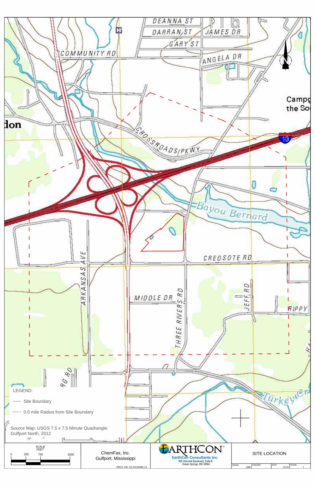
LEGEND:
Site Boundary
0.5 mile Radius from Site Boundary
Source Map: USGS 7.5 x 7.5 Minute Quadrangle:
Gulfport North, 2012
PROJ. NO: 02.20130380.13
FIGURE:DATE:CHECKED:DRAWN:
EarthCon Consultants Inc.
900 Holcomb Boulevard, Suite BOcean Springs, MS 39564
ChemFax, Inc.
Gulfport, Mississippi
CMF - 01/14 1
SITE LOCATION
SCALE
FEET
0 750 1500325
PROJ. NO: 02.20130380.13
FIGURE:DATE:CHECKED:DRAWN:
EarthCon Consultants Inc.
900 Holcomb Boulevard, Suite BOcean Springs, MS 39564
ChemFax, Inc.
Gulfport, Mississippi
CMF - 11/13 1
NPDES SITE MAP
SCALE
FEET
0 150 30075
LEGEND:
Site Boundary Concrete Slab to be Removed
Excavation Area (change in surface water flow direction) Drainage Arrows
0-1 ft bgs Excavation Area CAMU - Location of Housekeeping Practices
0-3 ft bgs Excavation Area
0-6 ft bgs Excavation Area
Source Map: USGS 7.5 x 7.5 Minute Quadrangle: Gulfport North, 1994

PROJ. NO: 02.20130380.13
FIGURE:DATE:CHECKED:DRAWN:
EarthCon Consultants Inc.
900 Holcomb Boulevard, Suite BOcean Springs, MS 39564
ChemFax, Inc.
Gulfport, Mississippi
CMF - 01/14 3
SURVEYOR'S MAP
DRAWING NOT TO SCALE
SOURCE : A SURVEY MAP OF A 0.396 ACRE, A 7.406 ACRE AND A 9.811 ACRE PARCEL OF LAND SITUATED IN SECTION 16, T-7-S, R-11-W, CITY OF GULFPORT,
HARRISON COUNTY, MISSISSIPPI by J.V. BURKES & ASSOCIATES, INC. on 1/8/2014
Appendix A Large Construction Storm Water General Permit : NPDES Permit MSR10
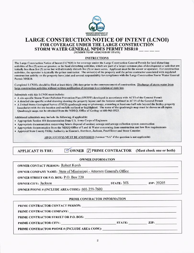
LARGE CONSTRUCTION NOTICE OF INTENT (LCNOI)F'OR COVERAGE UNDER THE LARGE CONSTRUCTION
sr oRM wArER G ENH"* * JJIJRffi,P,PSH,'ir MS R 1 0
INSTRUCTIONS
Thc l,arge Construction Notice of Intent (LCNOI) is for coveragc under thc Large Construction General Permit for land disturbingactivities of five (5) acres or greater; or for land disturbing activities, which are part of a larger common plan of development or sale that areinitialll, less than fir,e (5) acres but will ultimately disturb five (5) or more acres. Applicant must bc the owner or operator. For constructionactivities, the operator is typically the prime contractor. The owner(s) ofthe property and the prime contractor associated with regulatedconstruction activitl, on thc propertl' havc joint and sercral rcsponsibility' for compliancc with thc Large Construction Storm Water GeneralPermit NISRl0.
Completed LCNOIs should be filed at lcast thirty (30) da1's prior to thc commcncemcnt of construction. Discharse of storm water froma violation of state law.
Submittals with this LCNOI must includc:. A site-spccific Storm \\/atcr Pollution Prevention Plan (SWPPP) developcd in accordance with ACT5 of the Gcneral Permit. A detailed site-specific scaled drarving showing the properfy la1'out and thc features outlined in ACT5 of the General Permito A flnited Statcs Geological Sun'ey,GISCS) quadranglc map or photocopy, extending at lcast one-half milc beyond the facility property
boundaries lvith the site location and outfalls outlined or highlighted. The name of the quadrangle map must be shown on all copies.
Quadranglc maps can bc obtaincd from the NIDEQ' Office of Ceology at 601-961-5523.
Additional submittals may includc the following, if applicable:. Appropriate Section 404 documentation from l-J.S. Army Corps of Engineers. Appropriatc documentation concerning future disposal ofsanitary scwage and servage collection system construction. Appropriate documentation from the NIDEQ Office of Land & Water concerning dam construction and low flow requirements. Approval fromCountytltilityAuthorityinl{ancock, llarrison,Jackson,Pearl RiverandStoneCounties
All QTIESTIONS NIIIST BE ANSWERED (Answer "NA" if the question is not applicable)
APPLICANT IS THE: WNER E PRIME CONTRACTOR (Must check one or both)
OWNER INFORMATION
OWNER CONTACT PERSON: RObETt KETSh
owNER COMPANY NAME: State of Mississippi - Attorney General's Office
OWNER STREET OR P.O. BOX: P.O. Box220
OWNER CITY: JACKSON STATE: MS zrPz 39205
owNER PHONE # (INCLUDE AREA CODE): 601-359-7600
PRIME CONTRACTOR INFORMATION
PRIME CONTRACTOR CONTACT PERSON:
PRIME CONTRACTOR COMPANY:
PRIME CONTRACTOR STREET OR P.O. BOX:
PRIME CONTRACTOR CITY:
pRrME CONTRACTOR PHONE # (INCLUDE AREA CODE):
STATE: ZIP:
PROJECT INFORMATION
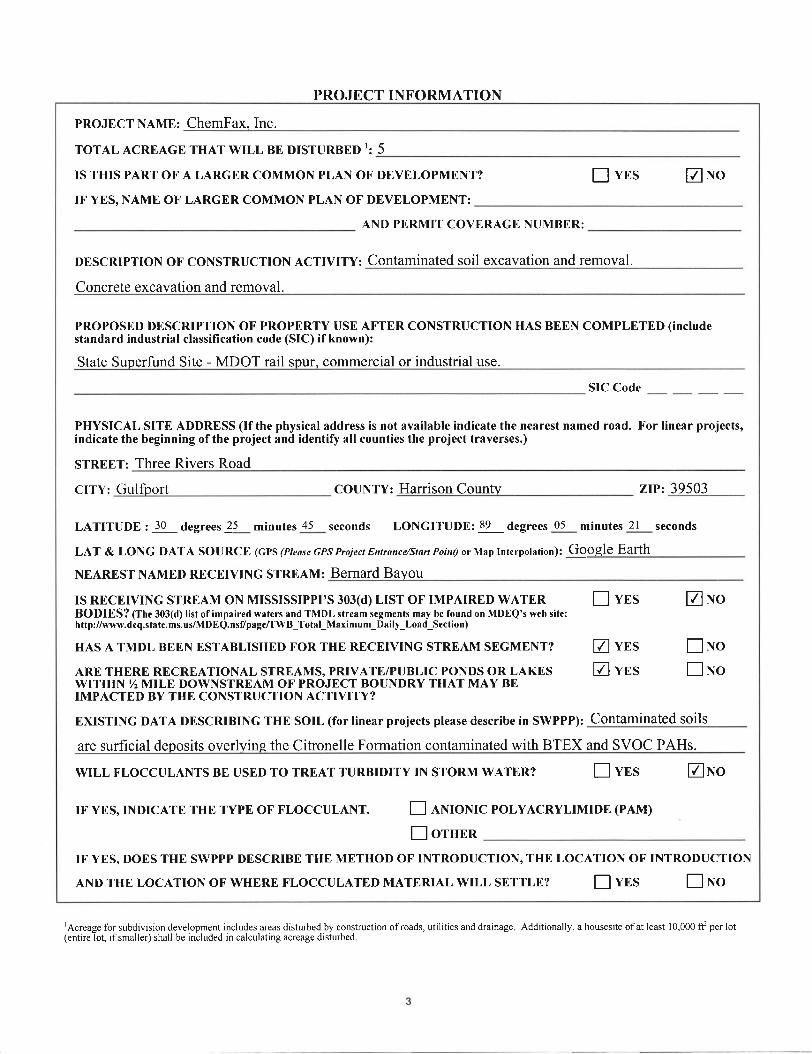
PROJECT NAME: ChemFax. Inc.
TOTAL ACREAGE THAT WILL BE DISTURBED 1: 5
IS THIS PART OF A LARGER COMMON PLAN OF DEVELOPMENT? ! vns ENoIF YES, NAME OF LARGER COMMON PLAN OF DEVELOPMENT:
AND PERMIT COVERAGE NUMBER:
DESCRIPTION OF CONSTRUCTION ACTMTY: Contaminated soil excavation and removal.
Concrete excavation and removal.
PROPOSED DESCRIPTION OF PROPERTY USE AFTER CONSTRUCTION HAS BEEN COMPLETED (includestandard industrial classification code (SIC) if known):
State Superfund Site - MDOT rail spur, commercial or industrial use.
SIC Code
PHYSICAL SITE ADDRESS (If the physical address is not available indicate the nearest named road. For linear projects,indicate the beginning ofthe project and identify all counties the project traverses.)
STREET: Three Rivers Road
CITY: Gulfborl COUNTY: Harrison CounW zrPz 39503
LATITUDE ; 30 6lsglss5 25 minutes 45 seconds LONGITUDE: 89 degrees 05 minutes 2l seconds
LAT & LONG DATA SOURCE (GPS (Pleose GPS Projecr Enrrnnce/Stort Poinl) or Nlap Interpolation)! GOOgle Eafth
NEAREST NAMED RECEIVING STREAM: BETNATd BAYOU
IS RECEIVING STREAM ON MISSISSIPPI'S 303(d) LIST OF IMPAIRED WATER ! VNS E NOBODIES? (The 303(d) list ot impaired waters and TMDL stream segments may be found on MDEQ's web site:h ttp://www.deq.sta te.ms.us/MDEQ.nsTpagc/TWB_Total_Maximum_Daily_Load_Scc tion)
HAS A TMDL BEEN ESTABLISHED FOR THE RECEIVING STREAM SEGMENT? [ VNS E NO
ARE THERE RECREATIONAL STREAMS, PRIVATE/PUBLIC PONDS OR LAKES E] YTS E NOWITHIN %NIILE DOWNSTREAM OF PROJECT BOUNDRY THAT MAY BEIMPACTED BY THE CONSTRUCTION ACTIVITY?
EXISTING DATA DESCRIBING THE SOIL (for linear projects please describe in SWPPP): Contaminated soils
are surficial deposits overlying the Citronelle Formation contaminated with BTEX and SVOC PAHs.
WILL FLOCCULANTS BE USED TO TREAT TURBIDITY IN STORM WATER? ! VNS ENO
IF YES,INDICATE THE TYPE OF FLOCCULANT. E INIONIC POLYACRYLIMIDE (PAM)
fl orspnIF YES, DOES THE SWPPP DESCRIBE THE METHOD OF INTRODUCTION, THE LOCATION OF INTRODUCTION
AND THE LOCATION OF WHERE FLOCCULATED MATERIAL WILL SETTLE? ! VTS E NO
rAcreage for subdivision development includes areas disturbed by construction ofroads, utrlities and drainage Additionally, a housesite ofat least 10,000 ff per lot(entire lot, rfsmaller) shall be included in calculating acreage disturbed
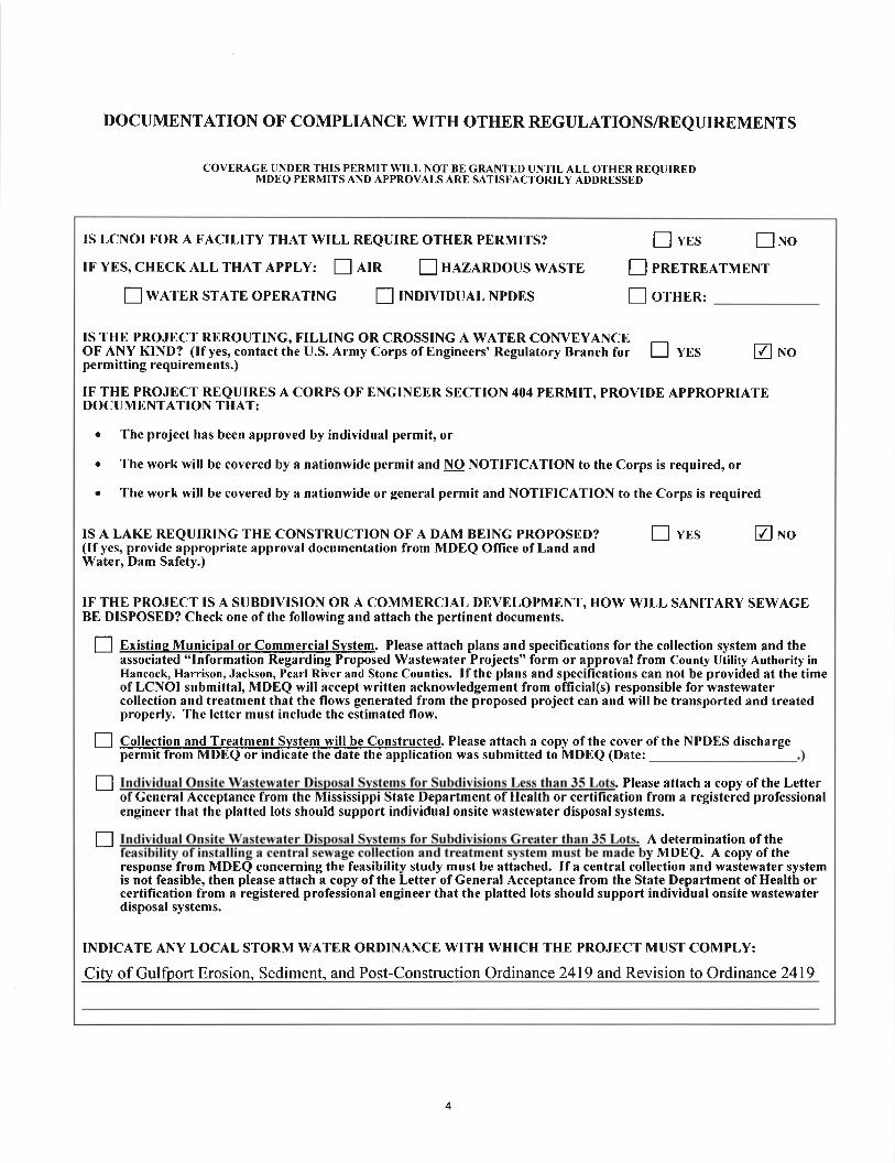
DOCUMENTATION OF COMPLIANCE WITH OTHER REGULATIONS/REQUIREMENTS
COVERAGE UNDER THIS PERMIT WILL NOT BE GRANTED UNTIL ALL OTHER REQUIREDIlIDEQ PERMITS AND APPROVALS ARE SATISFACTORILY ADDRESSED
IS LCNOI FOR A FACILITY THAT WILL REQUIRE OTHER PERMITS?
IF YES, CHECK ALL THAT Apply: E nIn ! nlZnnOOUS WASTE
!wnrnn srATE onERATTNG I lNorvrouAL NnDES
! vrs f]noI rnErnnATMENT
! orHen'
TS THE PROJECT REROUTING, FILLING OR CROSSING A WATER CONVEYANCEOF ANY KIND? (lf yes, contact tlie U.S. Army Corps of Engineers'Regulatory Branch for E vBS E Noperm itting requirements.)
IF THE PROJECT REQUIRES A CORPS OF ENGINEER SECTION 404 PERMIT, PROVIDE APPROPRIATEDOCUMENTATION THAT:
. The project has been approved by individual permit, or
o The work will be covered by a nationwide permit and NO NOTIFICATION to the Corps is required, or
o The work will be covered by a nationwide or general permit and NOTIFICATION to the Corps is required
IS A LAKE REQUIRING THE CONSTRUCTION OF A DAM BEING PROPOSED?(If yes, provide appropriate approval documentation from MDEQ OIIice of Land andWater, Dam Safety.)
E vns ENo
IF THE PROJECT IS A SUBDIVISION OR A COMMERCIAL DEVELOPMENT, HOW WILL SANITARY SEWAGEBE DISPOSED? Check one of the following and attach the pertinent documents.
f] Existins Municipal or Commercial Svstem. Please attach plans and specifications for the collection system and theassociated "Information Regarding Proposed Wastewater Projects" form or approval from County Utility Authority inHancock, Harrison, Jackson, Pearl River and Stone Counties. If the plans and specifications can not be provided at the timeof LCNOI submittal, MDEQ will accept written acknowledgement from official(s) responsible for wastewatercollection and treatment that the flows generated from the proposed project can and will be transported and treatedproperly. The letter must include the estimated flow.
l-l Collection and Treatment Svstem will be Constructed. Please attach a copy of the coverpermit from MDEQ or indicate the date the application was submitted to MDEQ (Date:
of the NPDES discharge
tr . Please attach a copy ofthe Letterof General Acceptance from the Mississippi State Department of Health or certification from a registered professionalengineer that the platted lots should support individual onsite wastewater disposal systems.
tr A determination of they MDEQ. A copy of the
response from MDEQ concerning the feasibility study must be attached. If a central collection and wastewater systemis not feasible, then please attach a copy of the Letter of General Acceptance from the State Department of Health orcertification from a registered professional engineer that the platted lots should support individual onsite wastewaterdisposal systems.
INDICATE ANY LOCAL STORM WATER ORDINANCE WITH WHICH THE PROJECT MUST COMPLY:
City of Gulfport Erosion, Sediment, and Post-Construction Ordinance 2419 and Revision to Ordinance 2419
4

I certify under penalty of law that this document and all attachments were prepared under my direction or supervision inaccordance with a system designed to assure that qualified personnel properly gathered and evaluated the informationsubmitted. Based on my inquiry of the person or persons who manage the system, or those persons directly responsible forgathering the information, the information submitted is, to the best of my knowledge and belief, true, accurate and complete.I am aware that there are significant penalties for submitting false information, including the possibility of fine andimprisonment for knowing violations.
rThis application shall be signed as follows:o For a corporation, by a responsible corporate officer.o For a partnership, by a general partner.o For a sole proprietorship, by the proprietor.o For a municipal, state or other public facility, by principal executive officer, mayor, or ranking elected official.
Please submit the LCNOI form to: Chief, Environmental Permits DivisionMS Department of Environmental Quality, Office of Pollution ControlP.O. Box 2261Jackson, Mississippi 39225
rzf rt lr3Date Signed
-rrrfisATitle
Revised 12116ll0

Appendix B Worksheets

Chemfax, Inc. Site
WORKSHEET UPDATE(S):
WORKSHEET 1
POLLUTION PREVENTION TEAM
MEMBER ROSTER
COMPLETED BY: TITLE: DATE:
LEADER: Craig Farmer
TITLE: Site Manager OFFICE PHONE: 601-850-7999
RESPONSIBILITIES: Responsible for: overall compliance with the terms of the NPDES Permit and SWPPP; budgeting SWPPP compliance costs; signatory
MEMBERS:
1 Lars Larson/Laura Sanchez
TITLE: Field Supervisor OFFICE PHONE: 228-872-3096
RESPONSIBILITIES: Responsible for environmental oversight, coordination, and maintaining a complete set of records in relation to the SWPPP for cap construction at the Chemfax, Inc. site a period of three years after the NOT has been submitted.
2 Lars Larson/Laura Sanchez
TITLE: Field Supervisor OFFICE PHONE: 228-872-3096
RESPONSIBILITIES: When responsible for: ensuring weekly site inspections are conducted and documented; identifying any deficiencies and potential BMPs to rectify the problem, ensuring quarterly visual and chemical storm water sampling and analysis is conducted as required by the permit; maintaining all records and documents as stipulated in the permit and SWPPP; and, timely preparation and submission of Discharge Monitoring Reports. Also, responsible for conducting preventative and periodic maintenance of all storm water controls as necessary; coordination and supervision of spill response actions. Also, responsible for responding to and assisting in the clean-up of any spills and the maintenance of storm water controls as necessary.
3 Lars Larson/Laura Sanchez
TITLE: Field Supervisor OFFICE PHONE: 228-872-3096
RESPONSIBILITIES: Responsible for responding to and assisting in the clean-up of any spills and the maintenance of storm water controls as necessary.
4 Lars Larson/Laura Sanchez
TITLE: Field Supervisor OFFICE PHONE: 228-872-3096
RESPONSIBILITIES: Responsible for comprehensive compliance evaluations of the SWPPP.
Chemfax, Inc. Site
WORKSHEET UPDATE(S):
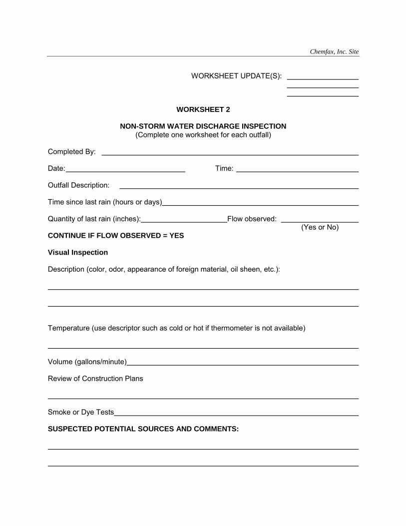
WORKSHEET 2
NON-STORM WATER DISCHARGE INSPECTION
(Complete one worksheet for each outfall) Completed By: Date: Time: Outfall Description: Time since last rain (hours or days) Quantity of last rain (inches): Flow observed: (Yes or No) CONTINUE IF FLOW OBSERVED = YES Visual Inspection Description (color, odor, appearance of foreign material, oil sheen, etc.): Temperature (use descriptor such as cold or hot if thermometer is not available) Volume (gallons/minute) Review of Construction Plans Smoke or Dye Tests SUSPECTED POTENTIAL SOURCES AND COMMENTS:

Chemfax, Inc. Site
WORKSHEET UPDATE(S):
WORKSHEET 3A
ELIGIBLE NON-STORM WATER DISCHARGE INSPECTION
(Complete one worksheet for each outfall) Completed By: Date: Time: Outfall Description: Time since last rain (hours or days) Quantity of last rain (inches): Flow observed: (Yes or No) CONTINUE IF FLOW OBSERVED = YES Visual Inspection Description (color, odor, appearance of foreign material, oil sheen, etc.): Temperature (use descriptor such as cold or hot if thermometer is not available) Volume (gallons/minute) Review of Construction Plans Smoke or Dye Tests SUSPECTED POTENTIAL SOURCES AND COMMENTS:
Chemfax, Inc. Site
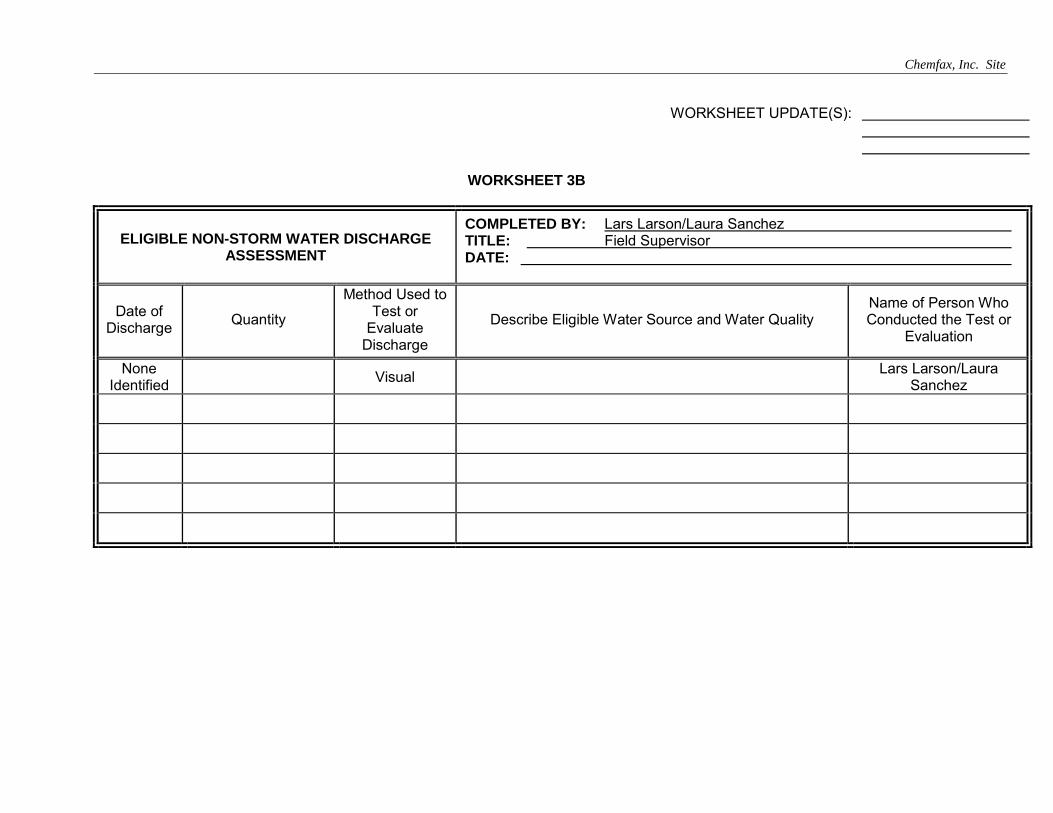
WORKSHEET UPDATE(S):
WORKSHEET 3B
ELIGIBLE NON-STORM WATER DISCHARGE ASSESSMENT
COMPLETED BY: Lars Larson/Laura Sanchez TITLE: Field Supervisor DATE:
Date of Discharge
Quantity
Method Used to Test or
Evaluate Discharge
Describe Eligible Water Source and Water Quality Name of Person Who Conducted the Test or
Evaluation
None Identified
Visual Lars Larson/Laura
Sanchez

Chemfax, Inc. Site
WORKSHEET UPDATE(S):
WORKSHEET 4
NON-STORM WATER DISCHARGE ASSESSMENT AND FAILURE TO CERTIFY NOTIFICATION
COMPLETED BY: TITLE: DATE:
Directions: If you cannot feasibly test or evaluate an outfall, fill in the table below with the appropriate information and sign this form to certify the accuracy of the included information.
List all outfalls not tested or evaluated, describe any potential sources of non-storm water pollution from listed outfalls, and state the reason(s) why certification is not possible. Use the key from your site map to identify each outfall.
Important Notice: If applicable, a copy of this notification must be signed and submitted to the Director within 180 days of the effective date of this permit.
Identify Outfall Not Tested/Evaluated
Description of Why Certification is Infeasible
Description of Potential Sources of Non-Storm Water Pollution
NOT REQUIRED, ALL OUTFALLS WERE VISUALLY OBSERVED, NO NON-STORM WATER DISCHARGE
NONE
CERTIFICATION
I certify under penalty of law that this document and all attachments were prepared under my direction or supervision in accordance with a system designed to assure that qualified personnel properly gather and evaluate the information submitted. Based on my inquiry of the person or persons who manage the system or those persons directly responsible for gathering the information, the information submitted is, to the best of my knowledge and belief, true, accurate, and complete. I am aware that there are significant penalties for submitting false information, including the possibility of fine and imprisonment of knowing violations, and that such notification has been made to the Director within 180 days of (date permit was issued), the effective date of this permit.
Name & Official Title (type or print):
Area Code and Telephone No:
Signature:
Date Signed:

Chemfax, Inc. Site
WORKSHEET UPDATE(S):
WORKSHEET 5
MATERIAL INVENTORY Completed By: Jay Ferris Title: Senior Geologist Date: 11/7/13
Instructions: List all materials used, stored, or produced on site. Assess and evaluate these materials for their potential to contribute pollutants to storm-water runoff. Also complete Worksheet 6 if the material has been exposed during the last three years.
Material Purpose/ Location Quantity (units)
Quantity Exposed In Last 3
Years
Likelihood of contact with storm water.
If yes, describe reason.
Past Significant
Spill or Leak
Used Produced Stored Yes No
N/A None

Chemfax, Inc. Site
WORKSHEET UPDATE(S):
WORKSHEET 6
DESCRIPTION OF EXPOSED SIGNIFICANT MATERIAL
COMPLETED BY: Jay Ferris TITLE: Senior Geologist DATE: 11/7/2013
Instructions: Based on your material inventory, describe the significant materials that were exposed to storm water during the past three years and/or are currently exposed.
Description of Exposed
Significant Material
Period of Exposure
Quantity Exposed (units)
Location (as indicated on
the site map)
Method of Storage or Disposal
(e.g. pile, drum, tank)
Material Management Practice and Structural/Non-structural
Controls in Use (e.g., pile covered, drum sealed)
Description of Treatment
N/A

Chemfax, Inc. Site
WORKSHEET UPDATE(S):
WORKSHEET 7
RISK IDENTIFICATION AND
POTENTIAL POLLUTANT SOURCES NARRATIVE
DATE: 11/7/13
The following is a summary of the potential pollutant sources associated with the construction
activities at the Chemfax, Inc. Site.
1. Soil excavation and moving – Soil excavation and moving is an integral part of the
construction activities in general. Soil moving is continuous and moves as the areas of
excavation expand. Soil excavation and moving will potentially affect primarily the Total
Suspended Solids (TSS) loading.
2. Significant materials storage - The storage of significant materials includes the
temporary storage of stockpiled soils used for backfilling excavation. The storage of
stockpiled soils will affect TSS while the temporary waste soil storage may affect TSS,
BOD, COD, N3, TKN, pH, Total P, Total Iron and a variety of other parameters
depending on the make-up of the waste soil.
3. Vehicle tracking of sediments - Vehicle tracking of sediments is a function of the
condition of the haul roads. Trucks that are required to operate on unimproved road
surfaces during wet weather will track mud to the entrance/exit and back onto the
improved public thoroughfares where there generally are no structural controls to
manage excess levels of mud. This mud, regardless of location will increase TSS levels.
Similarly, dry weather will generate dust that can contribute to increased TSS levels.

Chemfax, Inc. Site
4. Vehicle and equipment maintenance areas – Vehicle and equipment maintenance will
be limited as these activities can require the storage of significant quantities of chemicals
and petroleum products. The storage of these materials and their use in preventative
and corrective maintenance has the potential to contribute to storm water pollution
through exposure, spills and/or leaks. Typically, pollution from these activities would be
noted through increased levels of oils and greases, the presence of heavy metals,
ethylene glycol and/or pH changes.
5. Outdoor vehicle and equipment storage and parking - Storage/parking of equipment and
vehicles outdoors can result in fluid leaks in the storage/parking areas that contribute to
storm water pollution. This type of storm water pollution is typically manifested in
elevated levels of oil and grease, heavy metals, organics and fuel constituents such as
Benzene, Toluene, Ethylbenzene, and Xylene (BTEX).
6. Refueling points – The refueling area, if needed, has the potential to contribute to storm
water pollution due to spills and leaks during refueling, spills due to topping off vehicles,
and leaking or defective equipment. This type of storm water pollution will yield elevated
levels of BTEX, TPH, heavy metals, oils and greases. Any fuel storage will be kept at
minimal levels, inspected daily while in operation and any spills will be addressed
immediately to prevent storm water contact.
7. Equipment and vehicle washing activities - Vehicle and equipment washing is an
important part of equipment preventative maintenance. If not properly managed, wash
waters have the potential of contributing to storm water pollution. This will be noted
through increased levels of heavy metals, solvents, TSS, salts, and oils and greases.
8. Portable Toilet - Failure or the improper functioning of a portable toilet could result in
elevated levels of bacteria, BOD and TSS that could potentially affect storm water run
off.

Chemfax, Inc. Site
WORKSHEET UPDATE(S):
WORKSHEET 8
SWPPP SITE MAP COMPLETED BY: Christine Frost TITLE: Staff Engineer DATE: 11/72013
Instructions: If revision is made to the included site map note revisions on form and append to SWPPP.
MDEQ's General Permit requires that you indicate the following features on your site map:
1. Boundaries of property and proposed construction activities, noting any phasing of construction activities,
2. Original and proposed contours (if feasible), with side slopes identified, 3. North arrow, 4. Drainage pattern arrows, 5. Location of sensitive areas, such as wetlands, perennial streams and adjacent
receiving water bodies. 6. Location of any storm drain inlets, 7. All erosion and sediment controls, 8. Any post-construction control measures, and 9. Location of any housekeeping practices.

Chemfax, Inc. Site
WORKSHEET UPDATE(S):
WORKSHEET 9
LIST OF SIGNIFICANT SPILLS AND LEAKS COMPLETED BY: Jay Ferris TITLE: Senior Geologist DATE: 11/7/2013
Directions: Record below all significant spills and significant leaks of toxic or hazardous pollutants that have occurred at the facility in the three years prior to the effective date of the permit.
Definitions: Significant spills include, but are not limited to, releases of oil or hazardous substances in excess of reportable quantities.
1ST YEAR PRIOR
Date (m/d/y)
Spill Leak Location
(as indicated on site map)
Description Response Procedure
Preventive Measures
Taken Type of Material Quantity
Source, if known Reason
Amount of Material
Recovered
Material No Longer Exposed to
Storm Water (True/False)
NONE
2ND YEAR PRIOR
Date (m/d/y)
Spill Leak Location
(as indicated on site map)
Description Response Procedure
Preventive Measures
Taken Type of Material Quantity
Source, if known Reason
Amount of Material
Recovered
Material No Longer Exposed to
Storm Water (True/False)
NONE
3RD YEAR PRIOR
Date (m/d/y)
Spill Leak Location
(as indicated on site map)
Description Response Procedure
Preventive Measures
Taken Type of Material Quantity
Source, if known Reason
Amount of Material
Recovered
Material No Longer Exposed to
Storm Water (True/False)
NONE

Chemfax, Inc. Site
WORKSHEET UPDATE(S):
WORKSHEET 10
BMP IDENTIFICATION COMPLETED BY: Jay Ferris TITLE: Senior Geologist DATE: 11/7/2013
Instructions: Describe the Best Management Practices (BMPs) that you have selected to include in your plan. For each of the baseline BMPs, describe actions that will be incorporated into facility operations. Also describe any additional BMPs (activity-specific) and site-specific BMPs that you have selected.
BMPs BRIEF DESCRIPTION OF ACTIVITIES
Good Housekeeping Covered storage of soils etc. Daily clean-up of maintenance areas Use of drip pans where
appropriate Store significant materials away from traffic areas
Preventive Maintenance (PM) Conduct routine cleaning and PM of silt fences.
Inspections Conduct and document weekly inspections per the SWP3 Weekly Inspection Checklist.
Spill Prevention Response Adequate spill clean-up materials at maintenance, refueling and significant chemical storage areas
Spill and overfill protection Provide sorbent materials to filter stormwater accumulation in containment
area Post cautionary signs Provide spill response to refueling area Posted signs cautioning against overfilling/topping off
Sediment and Erosion Control Proper placement and use of structural controls: dikes, swales, check-dams, filter fences, sedimentation
ponds, pipe slope drains and outlet protection Vegetate barren areas Maintain natural vegetation
Temporary stabilization measures Road stabilization/improvement Use of wet weather areas
Dust control Road sweeping
Management of Runoff Apply fertilizer, etc., in accordance with manufacturer’s instructions Upgradient diversion berms
Downgradient toe berms Proper disposal of waste materials (oils, rags, fluids, etc.) Routine clean
up of equipment/vehicle lot Contain/dispose/recycle wash waters Do not use detergents
Additional BMPs (Activity-specific and Site-specific)
Recycle waste materials when appropriate

Chemfax, Inc. Site
WORKSHEET UPDATE(S):
WORKSHEET 11
EMPLOYEE TRAINING COMPLETED BY: Jay Ferris TITLE: Senior Geologist DATE: 11/7/2013
Instructions: Describe the employee training program for your facility below. The program should, at a minimum, address spill prevention and response, good housekeeping, and material management practices. Provide a schedule for the training program and list the employees who attend training sessions.
Training Topics Brief Description of Training Program/Materials
(e.g. film, newsletter course)
Schedule for Training
(list dates) Attendees
Storm Water Pollution Prevention
Review the SWPPP and BMPs that are to be implemented, discuss good housekeeping procedures and material management practices as they relate to construction operations
Site Orientation (Once)
Construction and compliance personnel
Spill Prevention and Response
Discuss Material Safety Data Sheets (MSDS) and how to interpret, review spill clean-up materials and their locations
If Necessary Construction and compliance personnel
Other Topics
Other routine training classes such as, Right to Know and SPCC, may also apply to Storm Water Pollution Prevention. Copies of this information and rosters are available from the training representative
If Necessary As required

Chemfax, Inc. Site
WORKSHEET 12
SWP3 WEEKLY SITE INSPECTION CHECKLIST
AREA/ACTIVITY TO BE INSPECTED Circle One
Adds to SW
Pollution
Comments and/or Corrective Actions Taken
CONSTRUCTION FACILITIES
1) Adequate spill clean-up materials are available
Yes No N/A
2) Ground is clean and free of stains and spills
Yes No N/A
3) Grit traps/sumps are clean and serviceable
Yes No N/A
4) MSDS sheets available for all chemicals used
Yes No N/A
5) All containers are in good condition/closed
Yes No N/A
6) Equipment parking area is adequately maintained
Yes No N/A
STORAGE TANKS/REFUELING POINTS
Aboveground Storage Tanks
1) Tanks and piping are sound Yes No N/A
2) Secondary containment is sound and closed, if applicable.
Yes No N/A
3) Containment drain is sound, if applicable.
Yes No N/A
4) Spills in/out of containment are promptly cleaned up
Yes No N/A
5) If water is present in the secondary containment, is it free of visible sheen
Yes No N/A
Refueling Points
1) All required signs are provided and legible
Yes No N/A
2) Adequate spill clean-up materials are available
Yes No N/A
CHEMICAL/PETROLEUM STORAGE AREAS (OTHER THAN FUEL)
1) Stored materials are protected from the weather
Yes No N/A
2) Stored materials have adequate containment
Yes No N/A

Chemfax, Inc. Site
3) Stored materials are clearly labeled Yes No N/A
4) All containers are in good condition and closed
Yes No N/A
5) Adequate spill clean-up materials are available
Yes No N/A
CONSTRUCTION OPERATIONS
1) Adequate silt fences or the equivalent are provided
Yes No N/A
2) Adequate vegetation is established/maintained
Yes No N/A
3) Sediment and detention ponds are operable
Yes No N/A
4) Ditches and channels show significant erosion
Yes No N/A
5) Adequate cover is provided where needed
Yes No N/A
6) Water pumps contribute to erosion Yes No N/A
7) Leachate tanks/sumps/piping are in good condition
Yes No N/A
8) Upgradient diversion berms and downgradient containment berms are in place
Yes No N/A
9) Mud/dust is adequately controlled on the haul roads and at the entrance/exit
Yes No N/A
10) Other erosion control structures are functioning effectively
Yes No N/A
Rainfall since last inspection? YES NO If yes, how much (inches) and date? / Discharge from Outfalls? YES NO Inspection Completed by (signature): Date___ CC:

Chemfax, Inc. Site
WORKSHEET 13
WEEKLY VISUAL STORM WATER DISCHARGE ANALYSIS
Date: Location: Outfall # Time flow began (24 Hr Clock): Runoff due to: Rainfall / Snowmelt Time sample was collected*: (circle one) Duration of the storm event (Hours): Total Rainfall in inches: Days since last Rainfall of >0.1 inches: Estimate of total flow: gal * Sample must be collected within 30 minutes of initial discharge from outfall, if this is impractical collect within the first hour and document why. The following sample analysis is subjective in nature and when possible, should be conducted by the same individual each time, for consistency.
Parameter Evaluation
(1=Good 10=Bad) Comments/Description/Potential Source
(Be as descriptive as possible for each parameter)
Color
1 2 3 4 5 6 7 8 9 10 Clear Dark brown
Odor
1 2 3 4 5 6 7 8 9 10 None Pungent
Clarity
1 2 3 4 5 6 7 8 9 10 Clear Opaque
Floating Solids
1 2 3 4 5 6 7 8 9 10 None Covered
Settled Solids
1
1 2 3 4 5 6 7 8 9 10 None 1/2" > 1''
Suspended Solids
1
1 2 3 4 5 6 7 8 9 10 None Significant
Foam
1 2 3 4 5 6 7 8 9 10 None Significant
Oil Sheen
1 2 3 4 5 6 7 8 9 10 None Free product
Other indicators of pollution (note each)
1 2 3 4 5 6 7 8 9 10
1 - Evaluate after allowing sample to settle one hour Corrective actions recommended and person responsible for initiating corrective actions 1. 2. 3. Name of Sampler/Evaluator Signature of Sampler/Evaluator

Storm Water Pollution Prevention Plan December 2013 Chemfax, Inc. Site Gulfport, Harrison County, Mississippi
Appendix C Request for Termination (RFT) of Coverage

Request for Termination (RFT) of Coverage
LARGE CONSTRUCTION GENERAL PERMIT Coverage No. MSR10 __ __ __ __ County ______________________
(Fill in your Certificate of Coverage Number and County)
This form must be submitted within thirty (30) days of achieving final stabilization (see ACT13, T-13 of general permit). Failure to submit this form is a violation of permit conditions. The signatory of this form must be the owner or operator (prime contractor) who is the current coverage recipient (rather than the project manager or environmental consultant).
(Please Print or Type)
Project Name: _________________________________________________________________________________________________________________ Physical Site Street Address (if not available, indicate nearest named road): _____________________________________________________________ City: _____________________________________ County: _________________________________ Zip: ____________________ Coverage Recipient Company Name: _____________________________________________________________________________________________ Street Address / P.O. Box: _______________________________________________________________________________________________________ City: ____________________________________________________ State: __________________ Zip: ____________________ Coverage Recipient Contact Name and Position: __________________________________________________ Tel. #: (____)_____________
Has another owner(s) or operator(s) assumed control over all areas of the site that have not reached final stabilization?
RESIDENTIAL SUBDIVISIONS: YES. A copy of the Registration Form for Residential Lot Coverage for each lot or out parcel that has been sold and a site map, indicating which lots have been sold, are attached. NO. Coverage may not be terminated until all areas have reached final stabilization.
COMMERCIAL DEVELOPMENT: YES. A copy of the site map, indicating which out-parcels have been sold, is attached. NO. Coverage may not be terminated until all areas have reached final stabilization.
I certify under penalty of law that this document and all attachments were prepared under my direction or supervision in accordance with a system designed to assure that qualified personnel properly gathered and evaluated the information submitted. Based on my inquiry of the person or persons who manage the system, or those persons directly responsible for gathering the information, the information submitted is, to the best of my knowledge and belief, true, accurate and complete. I am aware that there are significant penalties for submitting false information, including the possibility of fines and imprisonment for knowing violations. I understand that by submitting this Request for Termination and receiving written confirmation, I will no longer be authorized to discharge storm water associated with construction activity under this general permit. Discharging pollutants associated with construction activity to waters of the State without proper permit coverage is a violation of state law. I also understand that the submittal of this Request for Termination does not release an owner or operator from liability for any violations of this permit or the Clean Water Act.
__________________________________ _________________ ________________________________ ________________ Authorized Name (Print) Telephone Signature Date Signed 1This application shall be signed according to the General Permit, ACT12, T-7 as follows: - For a corporation, by a responsible corporate officer. - For a partnership, by a general partner. - For a sole proprietorship, by the proprietor. - For a municipal, state or other public facility, by principal executive officer, mayor, or ranking elected official. After signing please mail to: Chief, Environmental Permits Division MS Department of Environmental Quality, Office of Pollution Control P.O. Box 2261 Jackson, Mississippi 39225
Revised: 12/21/10
16

Storm Water Pollution Prevention Plan December 2013
Chemfax, Inc. Site Gulfport, Harrison County, Mississippi
Appendix D SWPPP Certification