1
Status of Operational Satellite Data Assimilation at Environment Canada Gilles Verner 1 and Godelieve Deblonde 2 1 Meteorological Service of Canada, 2 Science and Technology Branch, Environment Canada and many others from both sections Introduction On November 16, 2011, Environment Canada has implemented a major upgrade to the Canadian Meteorological Center analysis and forecast suites. The upgrades include new data sources for assimilation. - IASI : 62 channels, sensitive to temperature below 150hPa; - SSMIS : 7 SSMI-like channels from DMSP-16, sensitive to temperature, humidity and surface wind speed (over oceans); - CSR : all 5 geostationnary satellites (previously 2 GOES satellite), one water vapor channel assimilated; - AIRS : assimilate upper level channels previously blacklisted within 30 o of both poles; - Humidity data from aircraft. Other improvements include : - Reduced horizontal thinning for all satellite radiance observations (250km 150km) - New sea-surface temperature analysis (Global 0.2 deg; Brasnett 2008 ) - Reduced background errors near the model top - Improved QC for AMV’s and unified radiance bias correction scheme In what follows, what refers to the former operational control is in blue and the new operational system is in red. 18th International TOVS Study Conference Toulouse, France. 21-27 March 2012 Concluding remarks Results show that the assimilation of the new data sources (IASI, SSMIS, CSR) as well as reduced thinning of radiances, therefore doubling the amount of data assimilated, has an overall very positive impact on the analyses and forecasts of the EC global 4D-Var system for both hemispheres. This upgrade was operationally implemented at CMC on November 16, 2011 for the global and the regional deterministic prediction systems. Changes to Satellites (e.g. GOES, MTSAT) occurred during the parallel run and will be incorporated after the migration to the IBM P7 computers. Data from DMSP F17 and F18 and AVHRR polar winds will also be incorporated. EnKF (GEPS) has 100-km grid, lid at 2 hPa: assimilates AMSU-A ch.4-11 and AMSUB ch.2-5 but thinning remained at 250-km; no AIRS / IASI Assimilation setup Observing network - Surface (SYNOP/SHIP/BUOYS/DRIFTER) - GOES-E/W (water vapor channel) - Radiosonde (TEMP/PILOT) - Meteosat7-9 (water vapor channel) - GPSRO (COSMIC. METOP, GRACEA, TERRASARX) - MTSAT-2 (water vapor channel) - Aircraft (temperature, wind, humidity) - NOAA15-16-18-19 & METOP-2, AQUA - AMV’s (Geo and Polar) (AMSUA, AMSUB/MHS) - Wind profiler (USA) - DMSP16 SSMIS (7 SSMI-like channels) - Scatterometer (METOP-2 Ascat) - AIRS (87 channels, all assimilated globally) - AMVs (Geo and Polar) - IASI (62 channels) Parallel Run Verification : January - March 2011 Verification of 6 day (144 hr) forecast (P) against radiosonde observations (O) for Northern and Southern Hemisphere Significance level (%) of bias and Std Dev O-144hr differences are shaded (red = experiment is better, blue = control is better) Mixed results for the bias but overall very positive results for standard deviation in both hemispheres. • UU, VV = W-E, S-N wind • GZ = geopotential height • TT = temperature • ES = dewpoint depression Bias Pressure (hPa) Pressure (hPa) Pressure (hPa) Number of channels per spectral bands 0 0 Suface and cloud properties 2420 – 2700 0 15 Temperature sounding (CO2 Band) 2350 – 2420 0 9 Temperature sounding 2150 – 2250 0 0 CO column amount 2100 – 2150 0 0 Water vapor temperature sounding 1650 – 2100 0 33 Water vapor temperature sounding 1210 – 1650 0 4 Surface and cloud properties 1070 – 1150 0 0 Ozone sounding 1000 – 1070 19 6 Surface and cloud properties 770 – 980 43 20 Temperature Sounding (CO2 Band) 650 – 770 IASI AIRS Spectral bands cm -1 GEM Model characteristics - Model top at 0.1 hPa (63km) - 33km resolution (800 x 600) L80 Data assimilation - 4D-Var, T108 (240x120) - analysis resolution 33km (800 x 600) Verification of 1-6 day forecasts against analysis: Anomaly correlation for 500 hPa Geopotential Height (GZ) Higher correlation is better Positive impact on both hemispheres forecasts Gain of about 6 hours predictability in NH and 3 hours in SH at day 5 Verification for 65 days Northern Hemisphere GZ 500 hPa forecasts (h) anomaly correlation Southern Hemisphere GZ 500 hPa forecasts (h) anomaly correlation • UU, VV = W-E, S-N wind • GZ = geopotential height • TT = temperature • ES = dewpoint depression Std Dev Pressure (hPa) Pressure (hPa) Pressure (hPa) Bias Std Dev Northern Hemisphere Southern Hemisphere GZ 500 hPa 120 h RMS N.H. # cases RMS > 80: OPS: 20 PAR 10 Arrows show occurrences of busts that were greatly reduced in comparison to operational Parallel Run Verification : time series January to June 2011 Comparison with other Centres : Winter 2012 to Winter 2011 Operational Implementation of New and Additional data 16 November 0600 UTC 1M 4M 3M 2M GZ 500 hPa 120 h A.Corr. S.H. # cases ACOR < .75: OPS: 29 PAR 15 Arrows show occurrences of busts that were greatly reduced in comparison to operational MSC NCEP UK-Met ECMWF N. H. Forecast errors (RMS) at Day-5 (120-hr) Winter 2011 Winter 2012 2.0 m error reduction represents about 4-h of gain in forecast skill in the medium range forecasts. 55.2 m 50.3 m 45.9 m 57.3 m 46.6 m 50.3 m 55.3 m 59.9 m Winter 2011 (Dec-Jan) Winter 2012 (Dec-Jan) In the Works RDPS to be upgraded to 4D-Var T200, 10-km grid by Summer 2012. GDPS to be upgraded to 25-km grid, 4D-Var T180 by Fall 2012. GEPS grid (EnKF) to 66-km grid (from 100-km) with multi-scale algorithm, same thinning as GDPS. Work is underway for NPP (ATMS and CrIS) initially using simulated data and RTTOV-10. Data from Metop-B to be incorporated later in 2012. Assimilation of bending angle instead of refractivity for GPS-RO, and GB-GPS (ZWD). Improved assimilation of aircraft and radiosonde data (full 4D trajectory). Additional AIRS and IASI channels, reduced radiance observation errors and possible further reduction in horizontal thinning. New 3D-Var Global sea-ice analysis. New unified assimilation system for GDPS and GEPS (En-Var and EnKF). Courtesy of S. Laroche

Status of Operational Satellite Data Assimilation at ... · Status of Operational Satellite Data Assimilation at Environment Canada Gilles Verner1 and GodelieveDeblonde 2 1Meteorological

Embed Size (px)

Citation preview

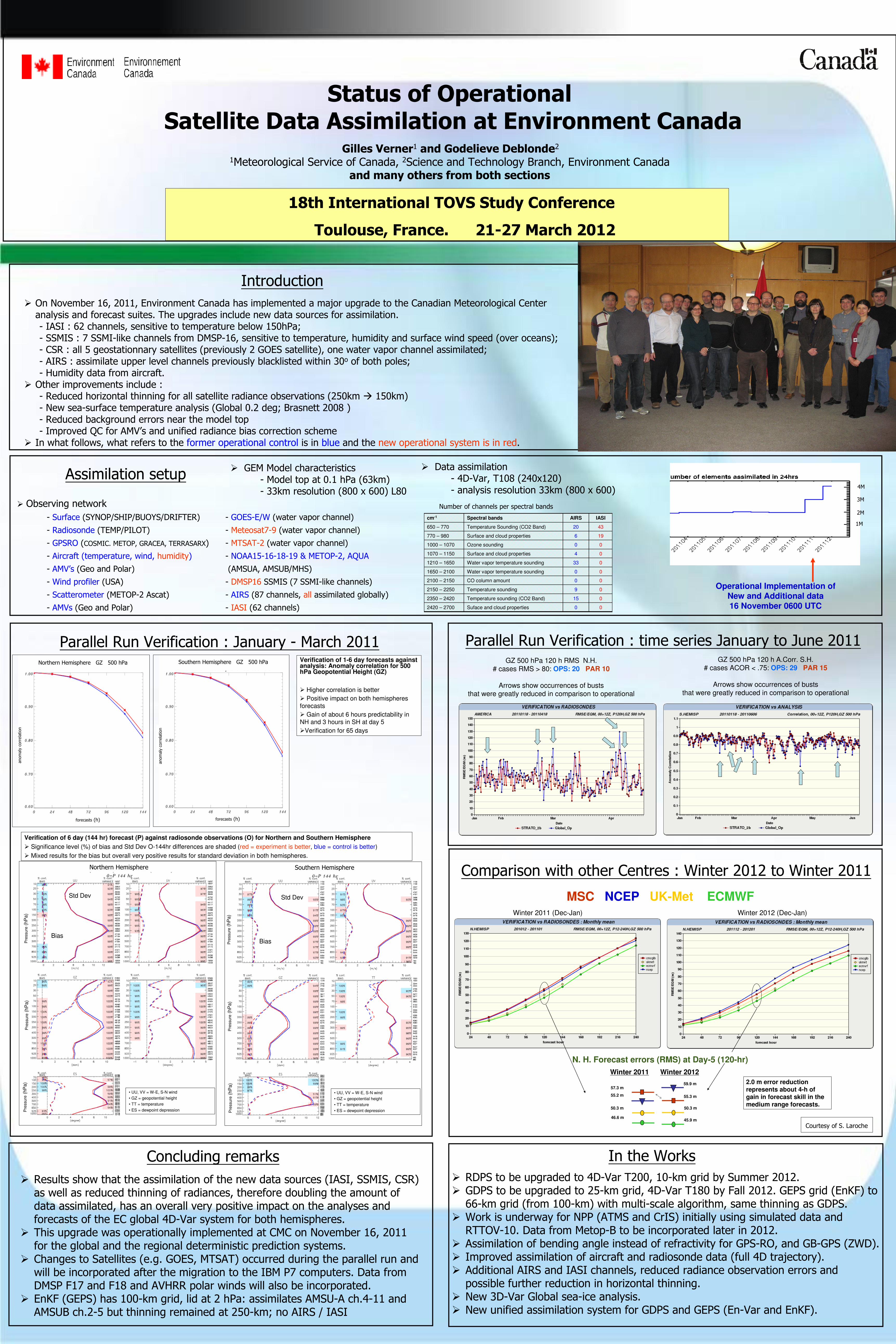
Status of OperationalSatellite Data Assimilation at Environment Canada

Gilles Verner1 and Godelieve Deblonde21Meteorological Service of Canada, 2Science and Technology Branch, Environment Canada

and many others from both sections

Introduction

� On November 16, 2011, Environment Canada has implemented a major upgrade to the Canadian Meteorological Center analysis and forecast suites. The upgrades include new data sources for assimilation.- IASI : 62 channels, sensitive to temperature below 150hPa;- SSMIS : 7 SSMI-like channels from DMSP-16, sensitive to temperature, humidity and surface wind speed (over oceans);- CSR : all 5 geostationnary satellites (previously 2 GOES satellite), one water vapor channel assimilated;- AIRS : assimilate upper level channels previously blacklisted within 30o of both poles;- Humidity data from aircraft.

� Other improvements include :- Reduced horizontal thinning for all satellite radiance observations (250km � 150km)- New sea-surface temperature analysis (Global 0.2 deg; Brasnett 2008 )- Reduced background errors near the model top- Improved QC for AMV’s and unified radiance bias correction scheme

� In what follows, what refers to the former operational control is in blue and the new operational system is in red.

18th International TOVS Study Conference

Toulouse, France. 21-27 March 2012

Concluding remarks

� Results show that the assimilation of the new data sources (IASI, SSMIS, CSR) as well as reduced thinning of radiances, therefore doubling the amount of data assimilated, has an overall very positive impact on the analyses and forecasts of the EC global 4D-Var system for both hemispheres.

� This upgrade was operationally implemented at CMC on November 16, 2011 for the global and the regional deterministic prediction systems.

� Changes to Satellites (e.g. GOES, MTSAT) occurred during the parallel run and will be incorporated after the migration to the IBM P7 computers. Data from DMSP F17 and F18 and AVHRR polar winds will also be incorporated.

� EnKF (GEPS) has 100-km grid, lid at 2 hPa: assimilates AMSU-A ch.4-11 and AMSUB ch.2-5 but thinning remained at 250-km; no AIRS / IASI

Assimilation setup

� Observing network

- Surface (SYNOP/SHIP/BUOYS/DRIFTER) - GOES-E/W (water vapor channel)

- Radiosonde (TEMP/PILOT) - Meteosat7-9 (water vapor channel)

- GPSRO (COSMIC. METOP, GRACEA, TERRASARX) - MTSAT-2 (water vapor channel)

- Aircraft (temperature, wind, humidity) - NOAA15-16-18-19 & METOP-2, AQUA

- AMV’s (Geo and Polar) (AMSUA, AMSUB/MHS)

- Wind profiler (USA) - DMSP16 SSMIS (7 SSMI-like channels)

- Scatterometer (METOP-2 Ascat) - AIRS (87 channels, all assimilated globally)

- AMVs (Geo and Polar) - IASI (62 channels)

Parallel Run Verification : January - March 2011

Verification of 6 day (144 hr) forecast (P) against radiosonde observations (O) for Northern and Southern Hemisphere

� Significance level (%) of bias and Std Dev O-144hr differences are shaded (red = experiment is better, blue = control is better)

� Mixed results for the bias but overall very positive results for standard deviation in both hemispheres.

• UU, VV = W-E, S-N wind

• GZ = geopotential height

• TT = temperature

• ES = dewpoint depression

Bias

Pre

ssu

re(h

Pa)

Pre

ssu

re(h

Pa)

Pre

ssu

re(h

Pa)

Number of channels per spectral bands

00Suface and cloud properties2420 – 2700

015Temperature sounding (CO2 Band)2350 – 2420

09Temperature sounding2150 – 2250

00CO column amount2100 – 2150

00Water vapor temperature sounding1650 – 2100

033Water vapor temperature sounding1210 – 1650

04Surface and cloud properties1070 – 1150

00Ozone sounding1000 – 1070

196Surface and cloud properties770 – 980

4320Temperature Sounding (CO2 Band)650 – 770

IASIAIRSSpectral bandscm-1

� GEM Model characteristics- Model top at 0.1 hPa (63km)- 33km resolution (800 x 600) L80

� Data assimilation- 4D-Var, T108 (240x120)- analysis resolution 33km (800 x 600)

Verification of 1-6 day forecasts against analysis: Anomaly correlation for 500 hPa Geopotential Height (GZ)

� Higher correlation is better

� Positive impact on both hemispheres

forecasts

� Gain of about 6 hours predictability in

NH and 3 hours in SH at day 5

�Verification for 65 days

Northern Hemisphere GZ 500 hPa

forecasts (h)

anomalycorrelation

Southern Hemisphere GZ 500 hPa

forecasts (h)

anomalycorrelation

• UU, VV = W-E, S-N wind

• GZ = geopotential height

• TT = temperature

• ES = dewpoint depression

Std Dev

Pre

ssu

re(h

Pa)

Pre

ssu

re(h

Pa)

Pre

ssu

re(h

Pa)

Bias

Std Dev

Northern Hemisphere Southern Hemisphere

GZ 500 hPa 120 h RMS N.H.# cases RMS > 80: OPS: 20 PAR 10

Arrows show occurrences of buststhat were greatly reduced in comparison to operational

Parallel Run Verification : time series January to June 2011

Comparison with other Centres : Winter 2012 to Winter 2011

Operational Implementation ofNew and Additional data

16 November 0600 UTC

1M

4M

3M

2M

GZ 500 hPa 120 h A.Corr. S.H.# cases ACOR < .75: OPS: 29 PAR 15

Arrows show occurrences of buststhat were greatly reduced in comparison to operational

MSC NCEP UK-Met ECMWF

N. H. Forecast errors (RMS) at Day-5 (120-hr)

Winter 2011 Winter 2012

2.0 m error reduction

represents about 4-h of

gain in forecast skill in the medium range forecasts.

55.2 m

50.3 m

45.9 m

57.3 m

46.6 m

50.3 m

55.3 m

59.9 m

Winter 2011 (Dec-Jan) Winter 2012 (Dec-Jan)

In the Works

� RDPS to be upgraded to 4D-Var T200, 10-km grid by Summer 2012.� GDPS to be upgraded to 25-km grid, 4D-Var T180 by Fall 2012. GEPS grid (EnKF) to

66-km grid (from 100-km) with multi-scale algorithm, same thinning as GDPS.� Work is underway for NPP (ATMS and CrIS) initially using simulated data and

RTTOV-10. Data from Metop-B to be incorporated later in 2012.� Assimilation of bending angle instead of refractivity for GPS-RO, and GB-GPS (ZWD).� Improved assimilation of aircraft and radiosonde data (full 4D trajectory).� Additional AIRS and IASI channels, reduced radiance observation errors and

possible further reduction in horizontal thinning.� New 3D-Var Global sea-ice analysis.� New unified assimilation system for GDPS and GEPS (En-Var and EnKF).

Courtesy of S. Laroche