Embed Size (px)
DESCRIPTION
The Joint Center for Satellite Data Assimilation. John Le Marshall Director, JCSDA. Deputy Directors : S tephen Lord – NWS /NCEP James Yoe - NESDIS Lars Peter Riishogjaard – GSFC, GMAO Pat Phoebus – DoD,NRL. June, 2005. PARTNERS. NOAA/NCEP. Environmental. Modeling Center. NOAA/OAR. - PowerPoint PPT Presentation
Citation preview

The Joint Center for Satellite Data Assimilation
John Le MarshallDirector JCSDA
June 2005
Deputy DirectorsStephen Lord ndash NWS NCEP James Yoe - NESDISLars Peter Riishogjaard ndash GSFC GMAOPat Phoebus ndash DoDNRL
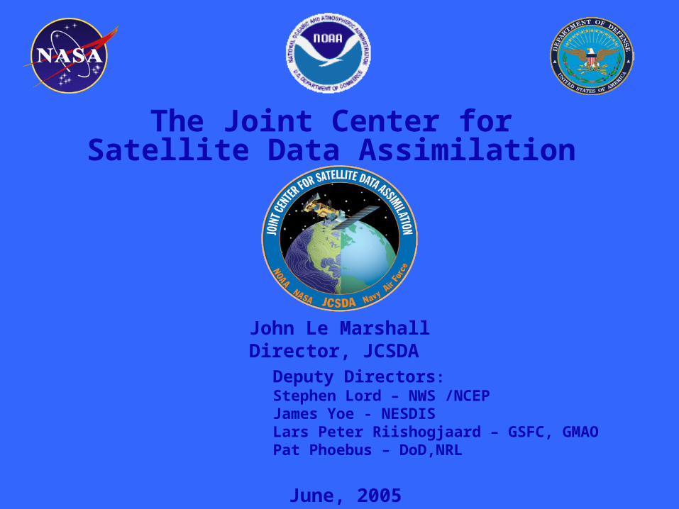
NASAGoddard
Global Modeling amp Assimilation Office
NOAANESDIS
Office of Research amp
Applications
NOAAOAR
Office of Weather and Air Quality
NOAANCEP
Environmental
Modeling Center
US Navy
Oceanographer of the NavyOffice of Naval Research (NRL)
US Air Force
AF Director of WeatherAF Weather Agency
PARTNERS
Joint Center for Satellite Data Assimilation
JCSDA Structure Associate Administrators
NASA ScienceNOAA NESDIS NWS OAR
DoD Navy Air Force
Management Oversight Board of DirectorsNOAA NWS L Uccellini (Chair)
NASA GSFC F EinaudiNOAA NESDIS M Colton
NOAA OAR M UhartNavy S Chang
USAF J LaniciM Farrar
AdvisoryPanel
Rotating Chair
ScienceSteering
Committee
Joint Center for Satellite Data Assimilation StaffDirector J Le Marshall
Deputy DirectorsStephen Lord ndash NWS NCEP
James Yoe - NESDIS Lars Peter Riishogjaard ndash GSFC GMAO
Pat Phoebus ndash DoDNRLSecretary Ada Armstrong
Consultant George Ohring
Technical LiaisonsNASAGMAO ndash D Dee
NOAANWSNCEP ndash J DerberNASAGMAO ndash M RieneckerNOAAOAR ndash A GasiewskiNOAANESDIS ndash D Tarpley
Navy ndash N BakerUSAF ndash M McATee
Army ndash G Mc Williams
JCSDA Advisory Board
bull Provides high level guidance to JCSDA Management Oversight Board
Name Organization
T Hollingsworth formerly ECMWF
T Vonder Haar CIRA
P Courtier Meteo France
E Kalnay UMD
R Anthes UCAR
J Purdom CIRA
P Rizzoli MIT
JCSDA Science Steering Committee
bull Provides scientific guidance to JCSDA Director Reviews proposals Reviews projects Reviews priorities
Name Organization
P Menzel (Chair) NESDIS
R Atlas GSFC
C Bishop NRL
R Errico GSFC
J Eyre UK Met Office
L Garand CMC
A McNally ECMWF
SKoch FSL
B Navasques KNMI
F Toepfer NWS
A Busalacchi ESSIC
JCSDA Technical Liaisons
bullTechnical Liaisons
- Represent their organizations - Review proposals and project progress - Interact with principal investigators
JCSDA Technical Liaisons
Liaison Name Organization
D Dee GMAO
J Derber EMC
M Rienecker GMAO
A Gasiewski OWAQR
D Tarpley ORA
N Baker NRL
M McAtee AFWA
JCSDA Mission and Vision
bull Mission Accelerate and improve the quantitative use of research and operational satellite data in weather climate and environmental analysis and prediction models
bull Vision A weather climate and environmental analysis and prediction community empowered to effectively assimilate increasing amounts of advanced satellite observations including the integrated observations of the GEOSS
Goals ndash ShortMedium Term
Increase uses of current and future satellite data in Numerical Weather and Climate Analysis and Prediction models
Develop the hardwaresoftware systems needed to assimilate data from the advanced satellite sensors
Advance common NWP models and data assimilation infrastructure
Develop a common fast radiative transfer system(CRTM)
Assess impacts of data from advanced satellite sensors on weather climate and environmental analysis and forecasts(OSEsOSSEs)
Reduce the average time for operational implementations of new satellite technology from two years to one
Goals ndash Longer Term
bull Provide the ldquobridgerdquo for the integrated use of GEOSS data within numerical models
Develop the tools for effective integration of GEOSS observations into environmental models
bull Expand assimilation system to provide input to models of environmental hazards air and water quality and resources terrestrial coastal and marine ecosystems climate variability and change agricultural productivity energy resources human health biodiversity
Required Capabilities to Achieve Goals
bull A satellite data assimilation infrastructure
bull A directed research and development program
bull A grants program for long-term research
bull An education and outreach program
Progress on Achieving CapabilitiesInfrastructure
bull JCSDA physical space established in NOAA Science Center
bull 23 NWS NESDIS scientists co-locatedbull GMAO visiting scientistsbull NSFAFWAOSDPD visiting scientistsbull JCSDA Staff
bull Common model infrastructurebull First version of community radiative transfer model developedbull NCEP Global Data Assimilation System implementation at Goddardbull NASA land data assimilation system (GLDAS) merged with NCEP land
data assimilation system (NOAH)
bull Interfaces to external researchers developed for radiative transfer model intercomparisons
Progress on Achieving CapabilitiesDirected R amp D Program
bull Supports projects generally aligned with shorter term objectives of JCSDA scientific priorities
bull Funded by the individual JCSDA organizations
bull Currently 17 projects
Directed RampD Program (FY05-AO)
Organization PI Title
EMC S Lord EMC Omnibus support for JCSDA Development
ORA F Weng Microwave Emissivity Model Upgrade
ORA D Tarpley Normalized Green Vegetation Fraction
ORA CPC EMC
F Flynn CLong S Lord Ozone Data Assimilation
ORA Y Han Beta Version CRTM Model
ORA S Kondragunta Biomass BurningAQForecasting
CIMMST Zapotoncny J Jung Satellite Data Impact Studies
ORA K Gallo Transition of Green Vegetation Fraction
CICS A Harris Physically-based AVHRR Bias Correction
ORA N Nalli IR Aerosol amp Ocean Sureface Reflectance Model
CIRAM Sengupta T Vukcevic All Weather Observational Operators
FSL D Birkenheuer Improved Moisture Assimilation Using Gradient Information
Progress on Achieving CapabilitiesGrants Program
bull Supports projects with longer term goals
bull Two annual Announcements of Opportunity completed 21 grants in place Average grant $100KYr
bull Special attention to paths from research to operations and coordination of PIs working in similar research areas
Grants Program (FY03-AO)
Improve radiative transfer model UCLA ndash Advanced radiative transfer UMBC ndash Including aerosols in OPTRAN NOAAETL ndash Fast microwave radiance assimilation studies
Prepare for advanced instruments U Wisconsin ndash Polar winds assimilation NASAGSFC ndash AIRS and GPS assimilation
Advance techniques for assimilating cloud and precipitation information U Wisconsin ndash Passive microwave assimilation of cloud and precipitation
Land data assimilation by improving emissivity modelssatellite products Boston U - Time varying land amp vegetation U Arizona ndash Satellite observation for snow data assimilation Colo State U ndash Surface emissivity error analysis NESDISORA ndash Retrievals of real-time vegetation properties
Improve use of satellite data in ocean data assimilationbull U Md ndash Ocean data assimilation bias correction
bull Columbia U ndash Use of altimeter data
bull NRL (Monterey) ndash Aerosol contamination in SST retrievals
Grants Program (FY04-AO)
Improve radiative transfer model AER Inc ndash Development of RT Models Based on the Optimal Spectral Sampling (OSS) Method NavyNRL - Assimilation of Passive Microwave Radiances over Land Use of the JCSDA
Common Microwave Emissivity Model (MEM) in Complex Terrain Regions NOAAETL ndash Fully polarmetric surface models and Microwave radiative transfer model UCLA ndash Vector radiative transfer model
Prepare for advanced instruments NavyNRL ndash SSMIS Brightness Temperature Evaluation in a Data Assimilation
Land data assimilation by improving emissivity modelssatellite products NASAGSFC - Assimilation of MODIS and AMSR-E Land Products into the Noah LSMU Princeton U - Development of improved forward models for retrieval of snow properties from
EOS-era satellites Boston U ndash Real time estimation and assimilation of remotely sensed data for NWP
Progress on Achieving CapabilitiesEducation and Outreach
bull JCSDA recognizes the scarcity of trained and qualified data assimilation scientists
bull JCSDA plans to establish a university center or consortium for education and training in satellite data assimilation
bull Newsletter
bull Web Page
bull Seminar Series
bull Workshops
The ChallengeSatellite SystemsGlobal Measurements
Aqua
Terra
TRMM
SORCE
SeaWiFS
Aura
MeteorSAGE
GRACE
ICESat
Cloudsat
Jason
CALIPSO
GIFTS
TOPEX
Landsat
NOAAPOES
GOES-R
WindSAT
NPP
COSMICGPS
SSMIS
NPOESS
12
3456789
10111213141516
171819202122
232425262728293031323334353637
A B C H I J K L M N O P Q R S T U V
Platform Instrument StatusTemper-
ature Humidity CloudPrecip-itation Wind Ozone
Land Surface
Ocean Surface Aerosols
Earth Radiation
Budget NOAA NAVY NASAAIR
FORCE
NAVY NON -ASSIM
SSMI Current v v v v v v 1 1 1 3 1SSMT v 3 3 3 1 2SSMT-2 v v 3 3 3 1 2SSMIS Current 2 1 2 3 1
OLS v v 3 2 3 3 2AMSU-A Current v v v v v v 1 1 1 3 1AMSU-B v v 1 1 1 3 1HIRS3 v v v v v v 1 1 1 3 1AVHRR v v v v 1 3 2SBUV v 1 1 1 3 2Imager v v v v v v v 2 1 2 3 1
Sounder v v v v v v 3 1 3 3 2GFO Altimeter Current v v 1 1 1 1 1
GMS (GOES-9) Imager Current v v v v v v3 1 3 3 1
Terra MODIS Current v v v v v v v v 2 1 2 1 1TMI Current v v v v v 2 2 2 1 1VIRS v v v 3 2 3 1 2
PR v 3 2 3 1 1CERES v 3 3 3 1 3
QuikSCAT Scatterometer Current v v 1 1 1 3 1TOPEX Altimeter Current TPW v v 1 1 1 2 1
JASON-1 Altimeter Current TPW v v 1 1 1 1 1AMSR-E Current v v v v v v 1 1 1 2 1AMSU v v v v v v 1 1 1 1 1HSB v v v 3 na 3 1 2AIRS v v v v v v 1 1 1 1 1
MODIS v v v v v v v v 2 1 1 1 1Envisat Altimeter Current v v v 1 1 1 2 1
MWR v v 2 1 2 2 1MIPAS v v 2 2 2 2 2AATSR v 2 1 2 1 2MERIS v v v v 2 2 2 2 1
SCIAMACHY v v v v 3 3 3 2 3GOMOS v 2 1 2 1 2
Satellite Instruments and Their Characteristics ( = currently assimilated in NWP)Primary Information Content
DMSP
POES
Current
TRMM
Aqua
Priority
GOES
Draft Sample Only
383940414243444546474849505152535455565758596061626364656667686970
A B C H I J K L M N O P Q R S T U VWindsat Polarimetric
radiometerCurrent SST TPW radic radic radic radic
2 1 2 2 1Aura OMI Current radic 1 1 1 1 2
MLS radic 2 2 2 1 2COSMIC GPS 2005 radic radic 1 2 1 2 1CHAMP GPS 2000 1 1 1 1 1
IASI 2005 radic radic radic radic radic radic 1 1 1 3 1ASCAT radic radic radic 1 1 1 3 2GRAS radic radic 1 2 1 2 3HIRS radic radic radic radic radic radic 1 1 1 3 3
AMSU radic radic radic radic radic radic 1 1 1 3 3MHS radic radic 1 1 1 3 1
GOME-2 radic 1 1 1 1 3AVHRR SST radic radic radic radic radic 1 1 1 3 1VIIRS 2006 SST radic radic radic radic 1 1 1 3 1CRIS radic radic radic radic radic radic 1 1 1 3 1OMPS 1 1 1 1 1ATMS radic radic radic radic radic radic 1 1 1 3 1
EO-3IGL GIFTS TBD radic radic radic radic radic radic radic radic 2 2 2 1 1SMOS MIRAS 2007 radic radic 1 2 1 2 1
VIIRS 2009 SST TPW radic Polar radic radic radic 1 1 1 3 1CRIS radic radic radic radic radic radic 1 1 1 3 1
ATMS radic radic radic radic radic radic 1 1 1 3 1CMIS radic radic radic radic radic radic radic 1 1 1 3 1
GPSOS radic radic 1 2 1 2 2APS radic 2 1 1 2 2
ERBS radic 3 3 3 1 3Altimeter radic radic 1 1 1 2 1
OMPS radic 1 1 1 1 1ADM Doppler lidar 2009 radic 1 1 1 2 1GPM GMI 2010 radic radic radic 2 2 2 2 1
DPR radic 2 2 2 2 1ABI 2012 radic radic radic radic radic radic 2 1 1 3 1HES radic radic radic radic radic radic radic 1 1 1 3 1
NPOESS
METOP
NPP
GOES R
Polar
Draft Sample Only
NPOESS SatelliteNPOESS Satellite
CMIS- μwave imagerVIIRS- visIR imager CrIS- IR sounderATMS- μwave sounder OMPS- ozoneGPSOS- GPS occultation ADCS- data collectionSESS- space environmentAPS- aerosol polarimeterSARSAT - search amp rescueTSIS- solar irradianceERBS- Earth radiation budgetALT- altimeterSS- survivability monitor
CMIS
VIIRSCrIS
ATMS
ERBSOMPS
The NPOESS spacecraft has the requirement to operate in three different sun synchronous orbits 1330 2130 and 1730 with different configurations of fourteen different environmental sensors that provide environmental data records (EDRs) for space oceanwater land radiation clouds and atmospheric parameters In order to meet this requirement the prime NPOESS contractor Northrop Grumman Space Technology is using their flight-qualified NPOESS T430 spacecraft This spacecraft leverages extensive experience on NASArsquos EOS Aqua and Aura programs that integrated similar sensors as NPOESS As was required for EOS the NPOESS T430 structure is an optically and dynamically stable platform specifically designed for earth observation missions with complex sensor suites In order to manage engineering design and integration risks a single spacecraft bus for all three orbits provides cost-effective support for accelerated launch call-up and operation requirement changes In most cases a sensor can be easily deployed in a different orbit because it will be placed in the same position on the any spacecraft There are ample resource margins for the sensors allowing for compensation due to changes in sensor requirements and future planned improvementsThe spacecraft still has reserve mass and power margin for the most stressing 1330 orbit which has eleven sensors The five panel solar array expandable to six is one design providing power in the different orbits and configurations
The NPOESS spacecraft has the requirement to operate in three different sun synchronous orbits 1330 2130 and 1730 with different configurations of fourteen different environmental sensors that provide environmental data records (EDRs) for space oceanwater land radiation clouds and atmospheric parameters In order to meet this requirement the prime NPOESS contractor Northrop Grumman Space Technology is using their flight-qualified NPOESS T430 spacecraft This spacecraft leverages extensive experience on NASArsquos EOS Aqua and Aura programs that integrated similar sensors as NPOESS As was required for EOS the NPOESS T430 structure is an optically and dynamically stable platform specifically designed for earth observation missions with complex sensor suites In order to manage engineering design and integration risks a single spacecraft bus for all three orbits provides cost-effective support for accelerated launch call-up and operation requirement changes In most cases a sensor can be easily deployed in a different orbit because it will be placed in the same position on the any spacecraft There are ample resource margins for the sensors allowing for compensation due to changes in sensor requirements and future planned improvementsThe spacecraft still has reserve mass and power margin for the most stressing 1330 orbit which has eleven sensors The five panel solar array expandable to six is one design providing power in the different orbits and configurations
5-Order Magnitude Increase in
satellite Data Over 10 Years
Count
(Mill
ions)
Daily Upper Air Observation Count
Year
Satellite Instruments by Platform
Count
NPOESSMETEOPNOAA
WindsatGOESDMSP
1990 2010Year
Satellite Data used in NWP
bull HIRS sounder radiancesbull AMSU-A sounder radiancesbull AMSU-B sounder radiancesbull GOES sounder radiancesbull GOES Meteosat GMS
windsbull GOES precipitation ratebull SSMI precipitation ratesbull TRMM precipitation ratesbull SSMI ocean surface wind
speedsbull ERS-2 ocean surface wind
vectors
bull Quikscat ocean surface wind vectors
bull AVHRR SSTbull AVHRR vegetation fractionbull AVHRR surface typebull Multi-satellite snow coverbull Multi-satellite sea icebull SBUV2 ozone profile and
total ozonebull Altimeter sea level
observations (ocean data assimilation)
bull AIRSbull Current Upgrade adds MODIS Windshellip
Short Term Priorities 0405
bull MODIS MODIS AMV assessment and enhancement Accelerate assimilation into operational models
bull AIRS Improved utilization of AIRS bull Improve data coverage of assimilated data Improve spectral content
in assimilated data bull Improve QC using other satellite data (eg MODIS AMSU) bull Investigate using cloudy scene radiances and cloud clearing optionsbull Improve RT Ozone estimatesbull Reduce operational assimilation time penalty (Transmittance Upgrade)
bull SSMIS Collaborate with the SSMIS CALVAL Team to jointly help assess SSMIS data Accelerate assimilation into operational model as appropriate
Short Term Priorities 0506
bull PREPARATIONS FOR METOP -METOPIASI
-Complete Community RTM transmittance preparation for IASI - Upgrade Analysis for IASI -Assimilate synthetic IASI BUFR radiances in preparation for
METOP - Complete preparations for HIRS AMSU MHS ASCAT GRAS
GOME-2 AVHRR)
bull SSMIS Collaborate with the SSMIS CALVAL Team to jointly help assess SSMIS data Accelerate assimilation into operational model as appropriate
bull GPS GPS (CHAMP) assimilation and assessment Prepare for (COSMIC) assimilation into operational model
ShortMedium Term Priorities
bull PREPARATION FOR NPP - CRIS ATMS OMPS VIIRS
bull PREPARATION FOR NPOESS- CRIS ATMS OMPS VIIRS CMISALTAPS
bull PREPARATION FOR GOES-R - Infrastructure - CRTM - HES ABI Assimilation
Some Major Accomplishments
bull Common assimilation infrastructure at NOAA and NASAbull Common NOAANASA land data assimilation systembull Interfaces between JCSDA models and external researchersbull Community radiative transfer model-Significant new developments New release
JuneJulybull Snowsea ice emissivity model ndash permits 300 increase in sounding data usage
over high latitudes ndash improved polar forecastsbull Advanced satellite data systems such as EOS (MODIS Winds Aqua AIRS
AMSR-E) tested for implementation -MODIS winds polar regions - improved forecasts Current Implementation -Aqua AIRS - improved forecasts Current Implementationbull Improved physically based SST analysisbull Advanced satellite data systems such as -DMSP (SSMIS) -CHAMP GPS being tested for implementationbull Impact studies of POES AMSU Quikscat GOES and EOS AIRSMODIS with
JCSDA data assimilation systems completed
JCSDA
RECENT ADVANCES
0
005
01
015
02
025
03
035
04
1 201 401 601 801 1001 1201 1401 1601 1801 2001 2201
AIRS channel num ber
RM
S d
iffe
ren
ce
(K
)
0
005
01
015
02
025
03
035
04
1 201 401 601 801 1001 1201 1401 1601 1801 2001 2201
AIRS channel number
rms
(K)
OPTRAN-V7 vs OSS at AIRS channels
OSS
OPTRAN
SSMIS Brightness Temperature Evaluation in a Data Assimilation Context
Summary of Accomplishments bull Worked closely with CalVal team to understand
assimilation implications of the sensor design and calibration anomalies and to devise techniques to mitigate the calibration issues
bull Completed code to read process and quality control observations apply scan non-uniformity and spillover corrections perform beam cell averaging of footprints and compute innovations and associated statistics
bull Developed flexible interface to pCRTM and RTTOV-7
bull Initial results indicate that pCRTM is performing well
Collaborators NRL Nancy Baker (PI) Clay Blankenship Bill Campbell Contributors Steve Swadley (METOC Consulting) Gene Poe (NRL)
Future Real time monitoring of SSMIS TBs Compare pCRTM with RTTOV-7 Assess observation and forward model bias and errors determine useful bias predictors Assess forecast impact of SSMIS assimilation
Reflector in Earth or SC shadow
Warm load intrusions
Reflector in sunlight
OB-BK full resolution (180 scene) TBs
ChanpCRTM
Bias
pCRTM
sd
RTTOV-7
Bias
RTTOV-7
sd
4 170 054 168 053
5 159 100 164 097
6 181 124 183 124
7 353 134 355 144
Figure 4 Impact of sea ice and snow emissivity models on the GFS 24 hr fcst at 850hPa (1 Jan ndash 15 Feb 2004) the pink curve shows theACC with new snow and sea ice emissivity models
Figure 7 Impact of MODIS AMVs on the operational GFS forecast at 500hPa (60degN - 90degN) (10 Aug ndash 23 Sept 2004) the pink (dashed) curve shows the ACC with (without) MODIS AMVs
N Hemisphere 850 mb AC Z 60N - 90N Waves 1-2010 Aug - 23 Sep 04
075
08
085
09
095
1
0 1 2 3 4 5
Forecast [days]
An
om
aly
Co
rre
lati
on
Control
Cntl+MODIS
Hyperspectral Data
Assimilation
AQUA
AIRS data coverage at 06 UTC on 31 January 2004 (Obs-Calc Brightness Temperatures at 6618 cm-1are shown)
Figure 5Spectral locations for 324 AIRS thinned channel data distributed to NWP centers
Table 2 AIRS Data Usage per Six Hourly Analysis Cycle
Data CategoryNumber of AIRS Channels
Total Data Input to AnalysisData Selected for Possible UseData Used in 3D VAR Analysis(Clear Radiances)
~200x106 radiances (channels) ~21x106 radiances (channels)~085x106 radiances (channels)
Figure1(a) 1000hPa Anomaly Correlations for the GFS with (Ops+AIRS) and without (Ops) AIRS data Southern hemisphere January 2004
S Hemisphere 1000 mb AC Z 20S - 80S Waves 1-20
1 Jan - 27 Jan 04
06
065
07
075
08
085
09
095
1
0 1 2 3 4 5 6 7
Forecast [days]
An
om
aly
Co
rrel
atio
n
Ops
Ops+AIRS
Figure 1(b) 500hPa Z Anomaly Correlations for the GFS with (Ops+AIRS) and without (Ops) AIRS data Southern hemisphere January 2004
S Hemisphere 500mb AC Z 20S - 80S Waves 1-20
1 Jan - 27 Jan 04
06
065
07
075
08
085
09
095
1
0 1 2 3 4 5 6 7
Forecast [days]
An
om
aly
Co
rrel
atio
n
Ops
Ops+AIRS
Figure 2 500hPa Z Anomaly Correlations 5 Day Forecast for the GFS with (Ops+AIRS) and without (Ops) AIRS data Southern hemisphere (1-27) January 2004
500 mb Anomaly Correlation Southern Hemisphere
5 Day Fcst
045
055
065
075
085
095
2 4 6 8 10 12 14 16 18 20 22
Day
An
om
aly
Co
rrel
atio
n
Ops
Ops+AIRS
Figure3(a) 1000hPa Anomaly Correlations for the GFS with (Ops+AIRS) and without (Ops) AIRS data Northern hemisphere January 2004
N Hemisphere 1000 mb AC Z 20N - 80N Waves 1-20
1 Jan - 27 Jan 04
06
065
07
075
08
085
09
095
1
0 1 2 3 4 5 6 7
Forecast [days]
An
om
aly
Co
rrel
atio
n
Ops
Ops+AIRS
Figure 3(b) 500hPa Z Anomaly Correlations for the GFS with (Ops+AIRS) and without (Ops) AIRS data Northern hemisphere January 2004
N Hemisphere 500 mb AC Z 20N - 80N Waves 1-20
1 Jan - 27 Jan 04
06
065
07
075
08
085
09
095
1
0 1 2 3 4 5 6 7
Forecast [days]
An
om
aly
Co
rrel
atio
n
Ops
Ops+AIRS
Improved NCEP SST AnalysisXu Li John Derber
EMCNCEP
Project Objective
To Improve SST Analysis
Use satellite data more effectively
Resolve diurnal variation
Improve first guess
Improved NCEP SST AnalysisXu Li John Derber
EMCNCEP Progress
SST physical retrieval code has been merged into GSI and provided to NCEP marine branch for test in operational mode
An extensive diagnostic study on the diurnal variation signals in in situ and satellite observations SST retrievals SST analysis and associated air-sea fluxes (NCEP GFS product) shows the SST diurnal variation needs to be addressed to improve the SST analysis product
7-day 6-hourly SST analysis has been produced with GSI after a new analysis variable in situ and AVHRR data were introduced into GSI
Plan Analyze SST by assimilating satellite radiances directly
with GSI Active ocean in the GFS Aerosol effects
NCEP Operational RTG Daily Analysis GSI Analysis (Daily Mean of 4 6-h analysis)
GSI (00Z ndash Daily Mean) GSI (12Z ndash Daily Mean)
SST Analysis with GSI Diurnal Variation signal and comparison with RTG Analysis04072005 (7th day of GSI SST analysis)
NCEP Operational RTG Daily Analysis GSI Analysis (Daily Mean of 4 6-h analysis)
GSI (00Z ndash Daily Mean) GSI (12Z ndash Daily Mean)
SST Analysis with GSI Diurnal Variation signal and comparison with RTG Analysis04072005 (7th day of GSI SST analysis)
JCSDA Ocean Data Assimilation
JCSDA partners - ocean analysesJCSDA partners - ocean analyses
bullNASAGMAO - seasonal climate forecastsNASAGMAO - seasonal climate forecasts
bullNCEPEMC Ocean and seasonal climate forecastsNCEPEMC Ocean and seasonal climate forecasts
bull Navy - ocean weather forecastsNavy - ocean weather forecasts
bull SST - Key intersection with Meteorology colleaguesSST - Key intersection with Meteorology colleagues
Key contributions sought in JCSDA collaborationsKey contributions sought in JCSDA collaborations
bull improved SSTbull improved surface forcingbull improved error covariances for surface forcing (particularly winds) bull improved observational error covariances (particularly altimetry) including representation error
bull improved ocean data assimilation methodology
The Global Ocean Data Assimilation System (GODAS) at NCEP
bull The primary purpose of the GODAS is to provide a global ocean analysis to initialize the NCEP Coupled Forecast System (CFS) for seasonal to interannual prediction
bull The GODAS is built on the GFDL Modular Ocean Model (MOMv3) and a 3D variational assimilation scheme
bull The GODAS has been operational since 2003 and the CFS since 2004
bull The following slide puts the GODAS in context
Seasonal to Interannual Forecasting at NCEP
Global OceanData AssimilationSystem (GODAS)
Coupled OceanAtmosphere Forecast
System (CFS03)
SST XBT TAO
Altimeter Argo
Scatterometer
Stress
E-P
Heat Fluxes
SST Anomaly Surface Temperatureamp Rainfall Anomalies
Official SST ForecastOfficial ProbabilisticSurface Temperatureamp Rainfall Forecasts
Seasonal Forecastsfor North America
with ClimateAtmosphere GCM
CCA CAMarkov
CCA OCNMR ENSO
Forecasters
Ocean Initial Conditions
IRI
IRI
The Global Ocean Data Assimilation System (GODAS) at NCEP
bull The operational version of GODAS assimilates temperature profiles and synthetic salinity profiles based on the temperature profile and a local climatological TS-relationship
bull Over most the past 25 years the number of available profiles has varied between 5000 and 6000 per month but within the last year the number has increased to more than 7000 per month as the Argo network fills in
bull The following slide illustrates the changing distribution of temperature profiles The most significant events in this regard have been the advent of the equatorial Pacific TAO moorings in the early 1990s and the growth of the Argo float network in the last few years
+ XBT + TAO + Argo
NCEPHYCOM dynamical model(Ocean Forecasting)
bull1048698 Sub-grid scale parameterizations
bullVertical and horizontal eddy viscosity and mixing Diapycnal mixing
bull1048698 Tide and sea surface pressure
bull1048698 River outflow and run-off
bull1048698 Primitive equation with free surface
bull1048698 Ice dynamics and thermodynamics
Central Setup Specifications
bullDynamical Model HYCOM 2013+ GISSbull[FCT-2] In-house adaptations for tidebullriver outflow ice model
bullInitialization Cold Start coastaldeepbullclimatologies followed by assimilationbullof historical data
bullSurface forcing GFS (NCEP) amp MODISbull(water type)
Central Setup 3
bullAssimilation Scheme Multi-variate 2D OIbullamp 2DVar with vertical extension
bullData Types SST SSH in-situ TS icebullConcentration
bullExtensions Prepare (T(z)S(z)) profilesbullfrom T(z) and SSHA
bullCovariance error Decomposed 3D tobull2DX1D
North Atlantic experiments andsetups in NCEP orthogonal
bull sigma2 25 levels
bull112 deg Initialization and assimilationbullResponse to a hurricane
bull13 deg Calibration of atmospheric forcing
bullSeasonal mixed layer variability
bullCalibration of tides
bull112 deg end-to-end operational system in trial
JCSDA Ocean Data Assimilation
bull Improved SST analysis (Xu Li and John Derber NCEPEMC)
bull Detection and correction of aerosol contamination in infrared SST retrievals (Jim Cummings NRLMonterey Andrew Harris NESDIS)
bull Ocean emissivityreflectance model (N Nalli NESDIS JCSDI)
bull Improving analysis of tropical upper ocean conditions for forecasting (Jim Carton)
bull Errors in sea level height analyses (Alexey Kaplan LDEO)
Improved NCEP SST AnalysisXu Li John Derber
EMCNCEP
Project Objective
To Improve SST Analysis
Use satellite data more effectively
Resolve diurnal variation
Improve first guess
Improved NCEP SST AnalysisXu Li John Derber
EMCNCEP Progress
SST physical retrieval code has been merged into GSI and provided to NCEP marine branch for test in operational mode
An extensive diagnostic study on the diurnal variation signals in in situ and satellite observations SST retrievals SST analysis and associated air-sea fluxes (NCEP GFS product) shows the SST diurnal variation needs to be addressed to improve the SST analysis product
7-day 6-hourly SST analysis has been produced with GSI after a new analysis variable in situ and AVHRR data were introduced into GSI
Plan Analyze SST by assimilating satellite radiances directly
with GSI Active ocean in the GFS Aerosol effects
NCEP Operational RTG Daily Analysis GSI Analysis (Daily Mean of 4 6-h analysis)
GSI (00Z ndash Daily Mean) GSI (12Z ndash Daily Mean)
SST Analysis with GSI Diurnal Variation signal and comparison with RTG Analysis04072005 (7th day of GSI SST analysis)
NCEP Operational RTG Daily Analysis GSI Analysis (Daily Mean of 4 6-h analysis)
GSI (00Z ndash Daily Mean) GSI (12Z ndash Daily Mean)
SST Analysis with GSI Diurnal Variation signal and comparison with RTG Analysis04072005 (7th day of GSI SST analysis)
Detection and correction of aerosol contamination in infrared seas surface temperature retrievals
Contributors NRL Jim Cummings (PI) Doug Westphal (PI) Jeff Hawkins NAVO Doug May UMD Andy Harris
bull Detection of aerosol contamination in infrared satellite sea surface temperature (SST) retrievals using Navy Aerosol Analysis Prediction System (NAAPS) aerosol distributions
bull Correction of satellite SSTs for aerosol contamination using NAAPS aerosol products
Project Objectives
Project TasksProject Tasks
bull Collocate NAAPS optical depth forecast fields valid for the time SST retrievals are generated (Doug May NAVOCEANO)
bull Estimate SST retrieval reliability relationship to AOD content (Doug May NAVOCEANO - Jim Cummings NRL)
bull Develop SST quality control schemes to recognize aerosol contamination (Jim Cummings NRL)
bull Correct satellite SSTs for aerosol contamination (Andy Harris NESDIS)
bull Validate NAAPS aerosol products using using independent data - improve NAAPS model (Jeff Hawkins Doug Westphal NRL)
JCSDA Workshop onSatellite Data Assimilation
Detection and correction of aerosol contamination in infrared seas surface temperature retrievals
Summary of Accomplishments
bull Collocation of NAVO AVHRR SSTs and NAAPS aerosol AODs for each aerosol type 4 times daily
bull Development of discriminant QC function to identify possible aerosol contamination
bull Validation of NAAPS AODs for select Saharan dust events using MODIS AOD retrievals
bull Development of reduced predictor scheme which improves correction of satellite BTs by at least a factor 3 over AOD alone
Contributors NRL Jim Cummings (PI) Doug Westphal (PI) Jeff Hawkins NAVO Doug May UMD Andy Harris
Future - Test correction scheme against aerosol-independent (eg MW) SST Use independent data to improve NAAPS product
NAAPS
01 04 16 64
MODIS
Point-for-point comparison in case study shows bi-modal distribution of bias
Addition of total clear-sky transmittance and air-sea T predictors improves BT correction
37 microm 11 microm 12 microm
Suggested form of k-estimation
ASAS
ASAS
ASAS
TTcTTccc
TTbTTbbb
TTaTTaaa
12321210
11321110
73327310
k
k-coefficients will be different for different aerosol types
Ocean Surface Reflection Ocean Surface Reflection Emissivity ModelEmissivity Model
Nicholas R NalliNicholas R Nalli
andand
Chris Barnet Walter Wolf Mitch Goldberg (Co-Is)Chris Barnet Walter Wolf Mitch Goldberg (Co-Is)
NOAANESDISORANOAANESDISORA
Paul van Delst John Derber (EMC POC)Paul van Delst John Derber (EMC POC)
NOAANCEPEMCNOAANCEPEMC
JSDIJSDI - FY05FY05
Enhancement of Ocean ReflectionEmissivity Enhancement of Ocean ReflectionEmissivity ModelModel
ContributorsContributors
ORA Nicholas Nalli (PI) C Barnet W Wolf M ORA Nicholas Nalli (PI) C Barnet W Wolf M GoldbergGoldberg
EMC P van Delst J DerberEMC P van Delst J Derber
Summary of AccomplishmentsSummary of Accomplishmentsbull Theoretical development of quasi-specular Theoretical development of quasi-specular
reflection model in earlier work (Nalli et al reflection model in earlier work (Nalli et al 2001)2001)
bull Sample M-AERI spectra collected from Sample M-AERI spectra collected from AEROSE 2004 to be published in AEROSE 2004 to be published in JGRJGR Special Issue on AIRS validation (Nalli et Special Issue on AIRS validation (Nalli et al 2005) ndash these data will be used to al 2005) ndash these data will be used to verify and validate modelsverify and validate models
bull UMBC Kcarta installed and compiled on UMBC Kcarta installed and compiled on Linux workstationLinux workstation
M-AERI Brightness Temperatures AEROSE 06-M-AERI Brightness Temperatures AEROSE 06-Mar-04Mar-04
From Nalli et al (2005)
FutureFuturebull Conduct statistical analyses of M-AERI field data to verifyquantify model errorConduct statistical analyses of M-AERI field data to verifyquantify model errorbull Characterize window channel spectral response functions and centroid Planck approximationsCharacterize window channel spectral response functions and centroid Planck approximationsbull Run forward radiance calculations for window channels over range of wind speeds zenith angles and atmospheric conditionsRun forward radiance calculations for window channels over range of wind speeds zenith angles and atmospheric conditionsbull Derive lookup tables andor parametric fit of reflection diffusivity angle designed to be used in conjunction with the Wu-Smith Derive lookup tables andor parametric fit of reflection diffusivity angle designed to be used in conjunction with the Wu-Smith
emissivity model currently implemented by NCEPEMCemissivity model currently implemented by NCEPEMCbull Validate model calculations against M-AERI spectra acquired during oceanographic field campaigns including AEROSE 2004Validate model calculations against M-AERI spectra acquired during oceanographic field campaigns including AEROSE 2004bull Tech transfer to NCEPEMC for operational implementation into CRTMTech transfer to NCEPEMC for operational implementation into CRTMbull Implementation within AIRS forward modelImplementation within AIRS forward model
Ocean Surface IR Emissivity Ocean Surface IR Emissivity and Reflectanceand Reflectancebull Radiance emissivity models (eg Masuda et al 1988 Radiance emissivity models (eg Masuda et al 1988
Watts et al 1996 Wu and Smith 1997) have been derived Watts et al 1996 Wu and Smith 1997) have been derived from Cox-Munk wave slope statisticsfrom Cox-Munk wave slope statistics
bull Lookup tables (LUT) of model emissivity are used in Lookup tables (LUT) of model emissivity are used in radiative transfer modeling radiative transfer modeling
bull Reflectance of atmospheric radiance is a more challenging Reflectance of atmospheric radiance is a more challenging problemproblemndash Surface is neither specular nor Lambertian but Surface is neither specular nor Lambertian but quasi-quasi-
specularspecularndash Depends upon the hemispherical radiance distributionDepends upon the hemispherical radiance distributionndash Using 1 Using 1 may lead to systematic errors of forward radiance may lead to systematic errors of forward radiance
in window channelsin window channelsndash These errors may be significant for applications requiring high These errors may be significant for applications requiring high
accuracy (eg SST)accuracy (eg SST)
)(1 0 Vf
Improved Analysis of Tropical Upper Ocean Conditions for Seasonal to Interannual Forecasting
Contributors UMD Jim Carton (PI) Gennady Chepurin EMC David Behringer
Collaborators Hailong Liu Ching-Yee Chang Sumant Nigam
Project Objectives
Identify the forecast bias in the current NCEP ocean assimilation system (GODAS) and explore methods to control its impact on forecasts
Observations have spatially correlated errors while ocean models have slowly varying biases Most current data assimilation schemes assume zero bias
Improved Analysis of Tropical Upper Ocean Conditions for Seasonal to Interannual Forecasting
faTfa
aTa
1f
1
a
P
ˆHQˆH
2
1)(J
Summary of Accomplishments
bull Identification of time mean and seasonal bias in ocean data assimilation
bull Development and coding of reduced space two-stage bias correction algorithm
bull Examination of systematic errors in seasonal cycle of CFS
Contributors UMD Jim Carton (PI) Gennady Chepurin EMC David Behringer
Collaborators Hailong Liu Ching-Yee Chang Sumant Nigam
Future - implementation and extension to multivariate Exploration of seasonal bias in CFS
Reduced-space bias correction
Where the bias is projected on our model EOFs G
Bias stationarity seasonality suggests a simple forecast bias model
95m temp b ias
Bias in temperature annual cycle
95m Temperature bias EOF decomposition
Sea level height errors in models and dataMonte Carlo simulations and spectral distributions
Contributors LDEO AKaplan (PI) MCane (co-PI) TMerlis
Collaborators GMAO ABorovikov MRienecker CKeppenne
Project goal to provide realistic initializations for ocean components of seasonal-to-interannual climate forecast systems by assimilating satellite observations
To achieve this goal we have to investigate the errors of observational and model data sets and the ways to model them statistically
Dynamical simulations of the ocean model error are still quite rare (CaneMillerKaplan et al Fukumori et al Borovikov et al 2005)
Sea level height errors in models and dataMonte Carlo simulations and spectral distributions
Summary of Accomplishmentsbull The AMIP-based ocean ensemble from GMAO
(Borovikov et al 2005) was analyzed and evaluated vs ensembles driven by small-scale noise
bull Ratios of temporal and spatial contributions to the small-scale sea surface height variability were analyzed and used for modeling observational error in monthly tide gauge sea level values wavenumber spectra are used for satellite altimetry error estimates with regards to the model grid size
Contributors LDEO AKaplan (PI) MCane (co-PI) TMerlis
Collaborators GMAO ABorovikov MRienecker CKeppenne
Future Finalizing error estimates ensembles of ocean simulations perturbed by small-scale variability data assimilation implementations
Latitudinal dependence of time evolution of normalized spread in sea surface height for the GMAO ensemble
Theoretical estimatesfor tide gauge error show goodconsistency with the actual errors for all tropical Pacific tide gauge stations but four (known to manifest local effects or phase shifts of Rossby waves)
Summary
From the workshopbull A lot of good progress
bull Collaborations on SST use of aerosol data - collaboration with Clark Weaver (and A da Silva) on aerosol productsinclude emissivityreflectance model in forward model in NCEP radiance assimilation include ocean mixed layer model (Li Harris Rienecker)
bull Collaborations on Assimilation methodology bias estimation (Carton Keppenne) methods to assimilate altimetry - noise models (Kaplan GMAO) ensemble generation (Kaplan GMAO)
Summary
bull Oceanic satellite data assimilation is one of JCSDArsquos mandates
bullSeveral Directed RampD and AO projects supported
bullInfrastructure issues to be addressed
bullKey advances already made
bullCoastalCoral Reef area a clear area for development
Prologue
bull JCSDA is well positioned to exploit the observational data base to be provided by the GOSGEOSS in terms of
bull Assimilation sciencebull Modeling sciencebull Computing power
Generally the next decade of the environmental satellite program promises to be every bit as exciting as the first given the opportunities provided by new observations modern data assimilation techniques improving environmental modeling capacity and burgeoning computer power
The Joint Center will play a key role in enabling the use of advanced satellite data from both current and future advanced systems for environmental modeling
USA Inc and the Global Community will be significant beneficiaries from the Centers activity
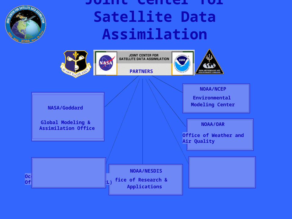
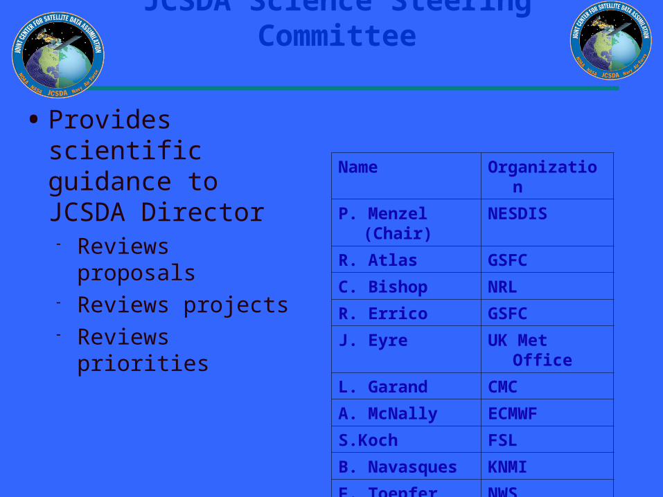
JCSDA Technical Liaisons
bullTechnical Liaisons
- Represent their organizations - Review proposals and project progress - Interact with principal investigators
JCSDA Technical Liaisons
Liaison Name Organization
D Dee GMAO
J Derber EMC
M Rienecker GMAO
A Gasiewski OWAQR
D Tarpley ORA
N Baker NRL
M McAtee AFWA
JCSDA Mission and Vision
bull Mission Accelerate and improve the quantitative use of research and operational satellite data in weather climate and environmental analysis and prediction models
bull Vision A weather climate and environmental analysis and prediction community empowered to effectively assimilate increasing amounts of advanced satellite observations including the integrated observations of the GEOSS
Goals ndash ShortMedium Term
Increase uses of current and future satellite data in Numerical Weather and Climate Analysis and Prediction models
Develop the hardwaresoftware systems needed to assimilate data from the advanced satellite sensors
Advance common NWP models and data assimilation infrastructure
Develop a common fast radiative transfer system(CRTM)
Assess impacts of data from advanced satellite sensors on weather climate and environmental analysis and forecasts(OSEsOSSEs)
Reduce the average time for operational implementations of new satellite technology from two years to one
Goals ndash Longer Term
bull Provide the ldquobridgerdquo for the integrated use of GEOSS data within numerical models
Develop the tools for effective integration of GEOSS observations into environmental models
bull Expand assimilation system to provide input to models of environmental hazards air and water quality and resources terrestrial coastal and marine ecosystems climate variability and change agricultural productivity energy resources human health biodiversity
Required Capabilities to Achieve Goals
bull A satellite data assimilation infrastructure
bull A directed research and development program
bull A grants program for long-term research
bull An education and outreach program
Progress on Achieving CapabilitiesInfrastructure
bull JCSDA physical space established in NOAA Science Center
bull 23 NWS NESDIS scientists co-locatedbull GMAO visiting scientistsbull NSFAFWAOSDPD visiting scientistsbull JCSDA Staff
bull Common model infrastructurebull First version of community radiative transfer model developedbull NCEP Global Data Assimilation System implementation at Goddardbull NASA land data assimilation system (GLDAS) merged with NCEP land
data assimilation system (NOAH)
bull Interfaces to external researchers developed for radiative transfer model intercomparisons
Progress on Achieving CapabilitiesDirected R amp D Program
bull Supports projects generally aligned with shorter term objectives of JCSDA scientific priorities
bull Funded by the individual JCSDA organizations
bull Currently 17 projects
Directed RampD Program (FY05-AO)
Organization PI Title
EMC S Lord EMC Omnibus support for JCSDA Development
ORA F Weng Microwave Emissivity Model Upgrade
ORA D Tarpley Normalized Green Vegetation Fraction
ORA CPC EMC
F Flynn CLong S Lord Ozone Data Assimilation
ORA Y Han Beta Version CRTM Model
ORA S Kondragunta Biomass BurningAQForecasting
CIMMST Zapotoncny J Jung Satellite Data Impact Studies
ORA K Gallo Transition of Green Vegetation Fraction
CICS A Harris Physically-based AVHRR Bias Correction
ORA N Nalli IR Aerosol amp Ocean Sureface Reflectance Model
CIRAM Sengupta T Vukcevic All Weather Observational Operators
FSL D Birkenheuer Improved Moisture Assimilation Using Gradient Information
Progress on Achieving CapabilitiesGrants Program
bull Supports projects with longer term goals
bull Two annual Announcements of Opportunity completed 21 grants in place Average grant $100KYr
bull Special attention to paths from research to operations and coordination of PIs working in similar research areas
Grants Program (FY03-AO)
Improve radiative transfer model UCLA ndash Advanced radiative transfer UMBC ndash Including aerosols in OPTRAN NOAAETL ndash Fast microwave radiance assimilation studies
Prepare for advanced instruments U Wisconsin ndash Polar winds assimilation NASAGSFC ndash AIRS and GPS assimilation
Advance techniques for assimilating cloud and precipitation information U Wisconsin ndash Passive microwave assimilation of cloud and precipitation
Land data assimilation by improving emissivity modelssatellite products Boston U - Time varying land amp vegetation U Arizona ndash Satellite observation for snow data assimilation Colo State U ndash Surface emissivity error analysis NESDISORA ndash Retrievals of real-time vegetation properties
Improve use of satellite data in ocean data assimilationbull U Md ndash Ocean data assimilation bias correction
bull Columbia U ndash Use of altimeter data
bull NRL (Monterey) ndash Aerosol contamination in SST retrievals
Grants Program (FY04-AO)
Improve radiative transfer model AER Inc ndash Development of RT Models Based on the Optimal Spectral Sampling (OSS) Method NavyNRL - Assimilation of Passive Microwave Radiances over Land Use of the JCSDA
Common Microwave Emissivity Model (MEM) in Complex Terrain Regions NOAAETL ndash Fully polarmetric surface models and Microwave radiative transfer model UCLA ndash Vector radiative transfer model
Prepare for advanced instruments NavyNRL ndash SSMIS Brightness Temperature Evaluation in a Data Assimilation
Land data assimilation by improving emissivity modelssatellite products NASAGSFC - Assimilation of MODIS and AMSR-E Land Products into the Noah LSMU Princeton U - Development of improved forward models for retrieval of snow properties from
EOS-era satellites Boston U ndash Real time estimation and assimilation of remotely sensed data for NWP
Progress on Achieving CapabilitiesEducation and Outreach
bull JCSDA recognizes the scarcity of trained and qualified data assimilation scientists
bull JCSDA plans to establish a university center or consortium for education and training in satellite data assimilation
bull Newsletter
bull Web Page
bull Seminar Series
bull Workshops
The ChallengeSatellite SystemsGlobal Measurements
Aqua
Terra
TRMM
SORCE
SeaWiFS
Aura
MeteorSAGE
GRACE
ICESat
Cloudsat
Jason
CALIPSO
GIFTS
TOPEX
Landsat
NOAAPOES
GOES-R
WindSAT
NPP
COSMICGPS
SSMIS
NPOESS
12
3456789
10111213141516
171819202122
232425262728293031323334353637
A B C H I J K L M N O P Q R S T U V
Platform Instrument StatusTemper-
ature Humidity CloudPrecip-itation Wind Ozone
Land Surface
Ocean Surface Aerosols
Earth Radiation
Budget NOAA NAVY NASAAIR
FORCE
NAVY NON -ASSIM
SSMI Current v v v v v v 1 1 1 3 1SSMT v 3 3 3 1 2SSMT-2 v v 3 3 3 1 2SSMIS Current 2 1 2 3 1
OLS v v 3 2 3 3 2AMSU-A Current v v v v v v 1 1 1 3 1AMSU-B v v 1 1 1 3 1HIRS3 v v v v v v 1 1 1 3 1AVHRR v v v v 1 3 2SBUV v 1 1 1 3 2Imager v v v v v v v 2 1 2 3 1
Sounder v v v v v v 3 1 3 3 2GFO Altimeter Current v v 1 1 1 1 1
GMS (GOES-9) Imager Current v v v v v v3 1 3 3 1
Terra MODIS Current v v v v v v v v 2 1 2 1 1TMI Current v v v v v 2 2 2 1 1VIRS v v v 3 2 3 1 2
PR v 3 2 3 1 1CERES v 3 3 3 1 3
QuikSCAT Scatterometer Current v v 1 1 1 3 1TOPEX Altimeter Current TPW v v 1 1 1 2 1
JASON-1 Altimeter Current TPW v v 1 1 1 1 1AMSR-E Current v v v v v v 1 1 1 2 1AMSU v v v v v v 1 1 1 1 1HSB v v v 3 na 3 1 2AIRS v v v v v v 1 1 1 1 1
MODIS v v v v v v v v 2 1 1 1 1Envisat Altimeter Current v v v 1 1 1 2 1
MWR v v 2 1 2 2 1MIPAS v v 2 2 2 2 2AATSR v 2 1 2 1 2MERIS v v v v 2 2 2 2 1
SCIAMACHY v v v v 3 3 3 2 3GOMOS v 2 1 2 1 2
Satellite Instruments and Their Characteristics ( = currently assimilated in NWP)Primary Information Content
DMSP
POES
Current
TRMM
Aqua
Priority
GOES
Draft Sample Only
383940414243444546474849505152535455565758596061626364656667686970
A B C H I J K L M N O P Q R S T U VWindsat Polarimetric
radiometerCurrent SST TPW radic radic radic radic
2 1 2 2 1Aura OMI Current radic 1 1 1 1 2
MLS radic 2 2 2 1 2COSMIC GPS 2005 radic radic 1 2 1 2 1CHAMP GPS 2000 1 1 1 1 1
IASI 2005 radic radic radic radic radic radic 1 1 1 3 1ASCAT radic radic radic 1 1 1 3 2GRAS radic radic 1 2 1 2 3HIRS radic radic radic radic radic radic 1 1 1 3 3
AMSU radic radic radic radic radic radic 1 1 1 3 3MHS radic radic 1 1 1 3 1
GOME-2 radic 1 1 1 1 3AVHRR SST radic radic radic radic radic 1 1 1 3 1VIIRS 2006 SST radic radic radic radic 1 1 1 3 1CRIS radic radic radic radic radic radic 1 1 1 3 1OMPS 1 1 1 1 1ATMS radic radic radic radic radic radic 1 1 1 3 1
EO-3IGL GIFTS TBD radic radic radic radic radic radic radic radic 2 2 2 1 1SMOS MIRAS 2007 radic radic 1 2 1 2 1
VIIRS 2009 SST TPW radic Polar radic radic radic 1 1 1 3 1CRIS radic radic radic radic radic radic 1 1 1 3 1
ATMS radic radic radic radic radic radic 1 1 1 3 1CMIS radic radic radic radic radic radic radic 1 1 1 3 1
GPSOS radic radic 1 2 1 2 2APS radic 2 1 1 2 2
ERBS radic 3 3 3 1 3Altimeter radic radic 1 1 1 2 1
OMPS radic 1 1 1 1 1ADM Doppler lidar 2009 radic 1 1 1 2 1GPM GMI 2010 radic radic radic 2 2 2 2 1
DPR radic 2 2 2 2 1ABI 2012 radic radic radic radic radic radic 2 1 1 3 1HES radic radic radic radic radic radic radic 1 1 1 3 1
NPOESS
METOP
NPP
GOES R
Polar
Draft Sample Only
NPOESS SatelliteNPOESS Satellite
CMIS- μwave imagerVIIRS- visIR imager CrIS- IR sounderATMS- μwave sounder OMPS- ozoneGPSOS- GPS occultation ADCS- data collectionSESS- space environmentAPS- aerosol polarimeterSARSAT - search amp rescueTSIS- solar irradianceERBS- Earth radiation budgetALT- altimeterSS- survivability monitor
CMIS
VIIRSCrIS
ATMS
ERBSOMPS
The NPOESS spacecraft has the requirement to operate in three different sun synchronous orbits 1330 2130 and 1730 with different configurations of fourteen different environmental sensors that provide environmental data records (EDRs) for space oceanwater land radiation clouds and atmospheric parameters In order to meet this requirement the prime NPOESS contractor Northrop Grumman Space Technology is using their flight-qualified NPOESS T430 spacecraft This spacecraft leverages extensive experience on NASArsquos EOS Aqua and Aura programs that integrated similar sensors as NPOESS As was required for EOS the NPOESS T430 structure is an optically and dynamically stable platform specifically designed for earth observation missions with complex sensor suites In order to manage engineering design and integration risks a single spacecraft bus for all three orbits provides cost-effective support for accelerated launch call-up and operation requirement changes In most cases a sensor can be easily deployed in a different orbit because it will be placed in the same position on the any spacecraft There are ample resource margins for the sensors allowing for compensation due to changes in sensor requirements and future planned improvementsThe spacecraft still has reserve mass and power margin for the most stressing 1330 orbit which has eleven sensors The five panel solar array expandable to six is one design providing power in the different orbits and configurations
The NPOESS spacecraft has the requirement to operate in three different sun synchronous orbits 1330 2130 and 1730 with different configurations of fourteen different environmental sensors that provide environmental data records (EDRs) for space oceanwater land radiation clouds and atmospheric parameters In order to meet this requirement the prime NPOESS contractor Northrop Grumman Space Technology is using their flight-qualified NPOESS T430 spacecraft This spacecraft leverages extensive experience on NASArsquos EOS Aqua and Aura programs that integrated similar sensors as NPOESS As was required for EOS the NPOESS T430 structure is an optically and dynamically stable platform specifically designed for earth observation missions with complex sensor suites In order to manage engineering design and integration risks a single spacecraft bus for all three orbits provides cost-effective support for accelerated launch call-up and operation requirement changes In most cases a sensor can be easily deployed in a different orbit because it will be placed in the same position on the any spacecraft There are ample resource margins for the sensors allowing for compensation due to changes in sensor requirements and future planned improvementsThe spacecraft still has reserve mass and power margin for the most stressing 1330 orbit which has eleven sensors The five panel solar array expandable to six is one design providing power in the different orbits and configurations
5-Order Magnitude Increase in
satellite Data Over 10 Years
Count
(Mill
ions)
Daily Upper Air Observation Count
Year
Satellite Instruments by Platform
Count
NPOESSMETEOPNOAA
WindsatGOESDMSP
1990 2010Year
Satellite Data used in NWP
bull HIRS sounder radiancesbull AMSU-A sounder radiancesbull AMSU-B sounder radiancesbull GOES sounder radiancesbull GOES Meteosat GMS
windsbull GOES precipitation ratebull SSMI precipitation ratesbull TRMM precipitation ratesbull SSMI ocean surface wind
speedsbull ERS-2 ocean surface wind
vectors
bull Quikscat ocean surface wind vectors
bull AVHRR SSTbull AVHRR vegetation fractionbull AVHRR surface typebull Multi-satellite snow coverbull Multi-satellite sea icebull SBUV2 ozone profile and
total ozonebull Altimeter sea level
observations (ocean data assimilation)
bull AIRSbull Current Upgrade adds MODIS Windshellip
Short Term Priorities 0405
bull MODIS MODIS AMV assessment and enhancement Accelerate assimilation into operational models
bull AIRS Improved utilization of AIRS bull Improve data coverage of assimilated data Improve spectral content
in assimilated data bull Improve QC using other satellite data (eg MODIS AMSU) bull Investigate using cloudy scene radiances and cloud clearing optionsbull Improve RT Ozone estimatesbull Reduce operational assimilation time penalty (Transmittance Upgrade)
bull SSMIS Collaborate with the SSMIS CALVAL Team to jointly help assess SSMIS data Accelerate assimilation into operational model as appropriate
Short Term Priorities 0506
bull PREPARATIONS FOR METOP -METOPIASI
-Complete Community RTM transmittance preparation for IASI - Upgrade Analysis for IASI -Assimilate synthetic IASI BUFR radiances in preparation for
METOP - Complete preparations for HIRS AMSU MHS ASCAT GRAS
GOME-2 AVHRR)
bull SSMIS Collaborate with the SSMIS CALVAL Team to jointly help assess SSMIS data Accelerate assimilation into operational model as appropriate
bull GPS GPS (CHAMP) assimilation and assessment Prepare for (COSMIC) assimilation into operational model
ShortMedium Term Priorities
bull PREPARATION FOR NPP - CRIS ATMS OMPS VIIRS
bull PREPARATION FOR NPOESS- CRIS ATMS OMPS VIIRS CMISALTAPS
bull PREPARATION FOR GOES-R - Infrastructure - CRTM - HES ABI Assimilation
Some Major Accomplishments
bull Common assimilation infrastructure at NOAA and NASAbull Common NOAANASA land data assimilation systembull Interfaces between JCSDA models and external researchersbull Community radiative transfer model-Significant new developments New release
JuneJulybull Snowsea ice emissivity model ndash permits 300 increase in sounding data usage
over high latitudes ndash improved polar forecastsbull Advanced satellite data systems such as EOS (MODIS Winds Aqua AIRS
AMSR-E) tested for implementation -MODIS winds polar regions - improved forecasts Current Implementation -Aqua AIRS - improved forecasts Current Implementationbull Improved physically based SST analysisbull Advanced satellite data systems such as -DMSP (SSMIS) -CHAMP GPS being tested for implementationbull Impact studies of POES AMSU Quikscat GOES and EOS AIRSMODIS with
JCSDA data assimilation systems completed
JCSDA
RECENT ADVANCES
0
005
01
015
02
025
03
035
04
1 201 401 601 801 1001 1201 1401 1601 1801 2001 2201
AIRS channel num ber
RM
S d
iffe
ren
ce
(K
)
0
005
01
015
02
025
03
035
04
1 201 401 601 801 1001 1201 1401 1601 1801 2001 2201
AIRS channel number
rms
(K)
OPTRAN-V7 vs OSS at AIRS channels
OSS
OPTRAN
SSMIS Brightness Temperature Evaluation in a Data Assimilation Context
Summary of Accomplishments bull Worked closely with CalVal team to understand
assimilation implications of the sensor design and calibration anomalies and to devise techniques to mitigate the calibration issues
bull Completed code to read process and quality control observations apply scan non-uniformity and spillover corrections perform beam cell averaging of footprints and compute innovations and associated statistics
bull Developed flexible interface to pCRTM and RTTOV-7
bull Initial results indicate that pCRTM is performing well
Collaborators NRL Nancy Baker (PI) Clay Blankenship Bill Campbell Contributors Steve Swadley (METOC Consulting) Gene Poe (NRL)
Future Real time monitoring of SSMIS TBs Compare pCRTM with RTTOV-7 Assess observation and forward model bias and errors determine useful bias predictors Assess forecast impact of SSMIS assimilation
Reflector in Earth or SC shadow
Warm load intrusions
Reflector in sunlight
OB-BK full resolution (180 scene) TBs
ChanpCRTM
Bias
pCRTM
sd
RTTOV-7
Bias
RTTOV-7
sd
4 170 054 168 053
5 159 100 164 097
6 181 124 183 124
7 353 134 355 144
Figure 4 Impact of sea ice and snow emissivity models on the GFS 24 hr fcst at 850hPa (1 Jan ndash 15 Feb 2004) the pink curve shows theACC with new snow and sea ice emissivity models
Figure 7 Impact of MODIS AMVs on the operational GFS forecast at 500hPa (60degN - 90degN) (10 Aug ndash 23 Sept 2004) the pink (dashed) curve shows the ACC with (without) MODIS AMVs
N Hemisphere 850 mb AC Z 60N - 90N Waves 1-2010 Aug - 23 Sep 04
075
08
085
09
095
1
0 1 2 3 4 5
Forecast [days]
An
om
aly
Co
rre
lati
on
Control
Cntl+MODIS
Hyperspectral Data
Assimilation
AQUA
AIRS data coverage at 06 UTC on 31 January 2004 (Obs-Calc Brightness Temperatures at 6618 cm-1are shown)
Figure 5Spectral locations for 324 AIRS thinned channel data distributed to NWP centers
Table 2 AIRS Data Usage per Six Hourly Analysis Cycle
Data CategoryNumber of AIRS Channels
Total Data Input to AnalysisData Selected for Possible UseData Used in 3D VAR Analysis(Clear Radiances)
~200x106 radiances (channels) ~21x106 radiances (channels)~085x106 radiances (channels)
Figure1(a) 1000hPa Anomaly Correlations for the GFS with (Ops+AIRS) and without (Ops) AIRS data Southern hemisphere January 2004
S Hemisphere 1000 mb AC Z 20S - 80S Waves 1-20
1 Jan - 27 Jan 04
06
065
07
075
08
085
09
095
1
0 1 2 3 4 5 6 7
Forecast [days]
An
om
aly
Co
rrel
atio
n
Ops
Ops+AIRS
Figure 1(b) 500hPa Z Anomaly Correlations for the GFS with (Ops+AIRS) and without (Ops) AIRS data Southern hemisphere January 2004
S Hemisphere 500mb AC Z 20S - 80S Waves 1-20
1 Jan - 27 Jan 04
06
065
07
075
08
085
09
095
1
0 1 2 3 4 5 6 7
Forecast [days]
An
om
aly
Co
rrel
atio
n
Ops
Ops+AIRS
Figure 2 500hPa Z Anomaly Correlations 5 Day Forecast for the GFS with (Ops+AIRS) and without (Ops) AIRS data Southern hemisphere (1-27) January 2004
500 mb Anomaly Correlation Southern Hemisphere
5 Day Fcst
045
055
065
075
085
095
2 4 6 8 10 12 14 16 18 20 22
Day
An
om
aly
Co
rrel
atio
n
Ops
Ops+AIRS
Figure3(a) 1000hPa Anomaly Correlations for the GFS with (Ops+AIRS) and without (Ops) AIRS data Northern hemisphere January 2004
N Hemisphere 1000 mb AC Z 20N - 80N Waves 1-20
1 Jan - 27 Jan 04
06
065
07
075
08
085
09
095
1
0 1 2 3 4 5 6 7
Forecast [days]
An
om
aly
Co
rrel
atio
n
Ops
Ops+AIRS
Figure 3(b) 500hPa Z Anomaly Correlations for the GFS with (Ops+AIRS) and without (Ops) AIRS data Northern hemisphere January 2004
N Hemisphere 500 mb AC Z 20N - 80N Waves 1-20
1 Jan - 27 Jan 04
06
065
07
075
08
085
09
095
1
0 1 2 3 4 5 6 7
Forecast [days]
An
om
aly
Co
rrel
atio
n
Ops
Ops+AIRS
Improved NCEP SST AnalysisXu Li John Derber
EMCNCEP
Project Objective
To Improve SST Analysis
Use satellite data more effectively
Resolve diurnal variation
Improve first guess
Improved NCEP SST AnalysisXu Li John Derber
EMCNCEP Progress
SST physical retrieval code has been merged into GSI and provided to NCEP marine branch for test in operational mode
An extensive diagnostic study on the diurnal variation signals in in situ and satellite observations SST retrievals SST analysis and associated air-sea fluxes (NCEP GFS product) shows the SST diurnal variation needs to be addressed to improve the SST analysis product
7-day 6-hourly SST analysis has been produced with GSI after a new analysis variable in situ and AVHRR data were introduced into GSI
Plan Analyze SST by assimilating satellite radiances directly
with GSI Active ocean in the GFS Aerosol effects
NCEP Operational RTG Daily Analysis GSI Analysis (Daily Mean of 4 6-h analysis)
GSI (00Z ndash Daily Mean) GSI (12Z ndash Daily Mean)
SST Analysis with GSI Diurnal Variation signal and comparison with RTG Analysis04072005 (7th day of GSI SST analysis)
NCEP Operational RTG Daily Analysis GSI Analysis (Daily Mean of 4 6-h analysis)
GSI (00Z ndash Daily Mean) GSI (12Z ndash Daily Mean)
SST Analysis with GSI Diurnal Variation signal and comparison with RTG Analysis04072005 (7th day of GSI SST analysis)
JCSDA Ocean Data Assimilation
JCSDA partners - ocean analysesJCSDA partners - ocean analyses
bullNASAGMAO - seasonal climate forecastsNASAGMAO - seasonal climate forecasts
bullNCEPEMC Ocean and seasonal climate forecastsNCEPEMC Ocean and seasonal climate forecasts
bull Navy - ocean weather forecastsNavy - ocean weather forecasts
bull SST - Key intersection with Meteorology colleaguesSST - Key intersection with Meteorology colleagues
Key contributions sought in JCSDA collaborationsKey contributions sought in JCSDA collaborations
bull improved SSTbull improved surface forcingbull improved error covariances for surface forcing (particularly winds) bull improved observational error covariances (particularly altimetry) including representation error
bull improved ocean data assimilation methodology
The Global Ocean Data Assimilation System (GODAS) at NCEP
bull The primary purpose of the GODAS is to provide a global ocean analysis to initialize the NCEP Coupled Forecast System (CFS) for seasonal to interannual prediction
bull The GODAS is built on the GFDL Modular Ocean Model (MOMv3) and a 3D variational assimilation scheme
bull The GODAS has been operational since 2003 and the CFS since 2004
bull The following slide puts the GODAS in context
Seasonal to Interannual Forecasting at NCEP
Global OceanData AssimilationSystem (GODAS)
Coupled OceanAtmosphere Forecast
System (CFS03)
SST XBT TAO
Altimeter Argo
Scatterometer
Stress
E-P
Heat Fluxes
SST Anomaly Surface Temperatureamp Rainfall Anomalies
Official SST ForecastOfficial ProbabilisticSurface Temperatureamp Rainfall Forecasts
Seasonal Forecastsfor North America
with ClimateAtmosphere GCM
CCA CAMarkov
CCA OCNMR ENSO
Forecasters
Ocean Initial Conditions
IRI
IRI
The Global Ocean Data Assimilation System (GODAS) at NCEP
bull The operational version of GODAS assimilates temperature profiles and synthetic salinity profiles based on the temperature profile and a local climatological TS-relationship
bull Over most the past 25 years the number of available profiles has varied between 5000 and 6000 per month but within the last year the number has increased to more than 7000 per month as the Argo network fills in
bull The following slide illustrates the changing distribution of temperature profiles The most significant events in this regard have been the advent of the equatorial Pacific TAO moorings in the early 1990s and the growth of the Argo float network in the last few years
+ XBT + TAO + Argo
NCEPHYCOM dynamical model(Ocean Forecasting)
bull1048698 Sub-grid scale parameterizations
bullVertical and horizontal eddy viscosity and mixing Diapycnal mixing
bull1048698 Tide and sea surface pressure
bull1048698 River outflow and run-off
bull1048698 Primitive equation with free surface
bull1048698 Ice dynamics and thermodynamics
Central Setup Specifications
bullDynamical Model HYCOM 2013+ GISSbull[FCT-2] In-house adaptations for tidebullriver outflow ice model
bullInitialization Cold Start coastaldeepbullclimatologies followed by assimilationbullof historical data
bullSurface forcing GFS (NCEP) amp MODISbull(water type)
Central Setup 3
bullAssimilation Scheme Multi-variate 2D OIbullamp 2DVar with vertical extension
bullData Types SST SSH in-situ TS icebullConcentration
bullExtensions Prepare (T(z)S(z)) profilesbullfrom T(z) and SSHA
bullCovariance error Decomposed 3D tobull2DX1D
North Atlantic experiments andsetups in NCEP orthogonal
bull sigma2 25 levels
bull112 deg Initialization and assimilationbullResponse to a hurricane
bull13 deg Calibration of atmospheric forcing
bullSeasonal mixed layer variability
bullCalibration of tides
bull112 deg end-to-end operational system in trial
JCSDA Ocean Data Assimilation
bull Improved SST analysis (Xu Li and John Derber NCEPEMC)
bull Detection and correction of aerosol contamination in infrared SST retrievals (Jim Cummings NRLMonterey Andrew Harris NESDIS)
bull Ocean emissivityreflectance model (N Nalli NESDIS JCSDI)
bull Improving analysis of tropical upper ocean conditions for forecasting (Jim Carton)
bull Errors in sea level height analyses (Alexey Kaplan LDEO)
Improved NCEP SST AnalysisXu Li John Derber
EMCNCEP
Project Objective
To Improve SST Analysis
Use satellite data more effectively
Resolve diurnal variation
Improve first guess
Improved NCEP SST AnalysisXu Li John Derber
EMCNCEP Progress
SST physical retrieval code has been merged into GSI and provided to NCEP marine branch for test in operational mode
An extensive diagnostic study on the diurnal variation signals in in situ and satellite observations SST retrievals SST analysis and associated air-sea fluxes (NCEP GFS product) shows the SST diurnal variation needs to be addressed to improve the SST analysis product
7-day 6-hourly SST analysis has been produced with GSI after a new analysis variable in situ and AVHRR data were introduced into GSI
Plan Analyze SST by assimilating satellite radiances directly
with GSI Active ocean in the GFS Aerosol effects
NCEP Operational RTG Daily Analysis GSI Analysis (Daily Mean of 4 6-h analysis)
GSI (00Z ndash Daily Mean) GSI (12Z ndash Daily Mean)
SST Analysis with GSI Diurnal Variation signal and comparison with RTG Analysis04072005 (7th day of GSI SST analysis)
NCEP Operational RTG Daily Analysis GSI Analysis (Daily Mean of 4 6-h analysis)
GSI (00Z ndash Daily Mean) GSI (12Z ndash Daily Mean)
SST Analysis with GSI Diurnal Variation signal and comparison with RTG Analysis04072005 (7th day of GSI SST analysis)
Detection and correction of aerosol contamination in infrared seas surface temperature retrievals
Contributors NRL Jim Cummings (PI) Doug Westphal (PI) Jeff Hawkins NAVO Doug May UMD Andy Harris
bull Detection of aerosol contamination in infrared satellite sea surface temperature (SST) retrievals using Navy Aerosol Analysis Prediction System (NAAPS) aerosol distributions
bull Correction of satellite SSTs for aerosol contamination using NAAPS aerosol products
Project Objectives
Project TasksProject Tasks
bull Collocate NAAPS optical depth forecast fields valid for the time SST retrievals are generated (Doug May NAVOCEANO)
bull Estimate SST retrieval reliability relationship to AOD content (Doug May NAVOCEANO - Jim Cummings NRL)
bull Develop SST quality control schemes to recognize aerosol contamination (Jim Cummings NRL)
bull Correct satellite SSTs for aerosol contamination (Andy Harris NESDIS)
bull Validate NAAPS aerosol products using using independent data - improve NAAPS model (Jeff Hawkins Doug Westphal NRL)
JCSDA Workshop onSatellite Data Assimilation
Detection and correction of aerosol contamination in infrared seas surface temperature retrievals
Summary of Accomplishments
bull Collocation of NAVO AVHRR SSTs and NAAPS aerosol AODs for each aerosol type 4 times daily
bull Development of discriminant QC function to identify possible aerosol contamination
bull Validation of NAAPS AODs for select Saharan dust events using MODIS AOD retrievals
bull Development of reduced predictor scheme which improves correction of satellite BTs by at least a factor 3 over AOD alone
Contributors NRL Jim Cummings (PI) Doug Westphal (PI) Jeff Hawkins NAVO Doug May UMD Andy Harris
Future - Test correction scheme against aerosol-independent (eg MW) SST Use independent data to improve NAAPS product
NAAPS
01 04 16 64
MODIS
Point-for-point comparison in case study shows bi-modal distribution of bias
Addition of total clear-sky transmittance and air-sea T predictors improves BT correction
37 microm 11 microm 12 microm
Suggested form of k-estimation
ASAS
ASAS
ASAS
TTcTTccc
TTbTTbbb
TTaTTaaa
12321210
11321110
73327310
k
k-coefficients will be different for different aerosol types
Ocean Surface Reflection Ocean Surface Reflection Emissivity ModelEmissivity Model
Nicholas R NalliNicholas R Nalli
andand
Chris Barnet Walter Wolf Mitch Goldberg (Co-Is)Chris Barnet Walter Wolf Mitch Goldberg (Co-Is)
NOAANESDISORANOAANESDISORA
Paul van Delst John Derber (EMC POC)Paul van Delst John Derber (EMC POC)
NOAANCEPEMCNOAANCEPEMC
JSDIJSDI - FY05FY05
Enhancement of Ocean ReflectionEmissivity Enhancement of Ocean ReflectionEmissivity ModelModel
ContributorsContributors
ORA Nicholas Nalli (PI) C Barnet W Wolf M ORA Nicholas Nalli (PI) C Barnet W Wolf M GoldbergGoldberg
EMC P van Delst J DerberEMC P van Delst J Derber
Summary of AccomplishmentsSummary of Accomplishmentsbull Theoretical development of quasi-specular Theoretical development of quasi-specular
reflection model in earlier work (Nalli et al reflection model in earlier work (Nalli et al 2001)2001)
bull Sample M-AERI spectra collected from Sample M-AERI spectra collected from AEROSE 2004 to be published in AEROSE 2004 to be published in JGRJGR Special Issue on AIRS validation (Nalli et Special Issue on AIRS validation (Nalli et al 2005) ndash these data will be used to al 2005) ndash these data will be used to verify and validate modelsverify and validate models
bull UMBC Kcarta installed and compiled on UMBC Kcarta installed and compiled on Linux workstationLinux workstation
M-AERI Brightness Temperatures AEROSE 06-M-AERI Brightness Temperatures AEROSE 06-Mar-04Mar-04
From Nalli et al (2005)
FutureFuturebull Conduct statistical analyses of M-AERI field data to verifyquantify model errorConduct statistical analyses of M-AERI field data to verifyquantify model errorbull Characterize window channel spectral response functions and centroid Planck approximationsCharacterize window channel spectral response functions and centroid Planck approximationsbull Run forward radiance calculations for window channels over range of wind speeds zenith angles and atmospheric conditionsRun forward radiance calculations for window channels over range of wind speeds zenith angles and atmospheric conditionsbull Derive lookup tables andor parametric fit of reflection diffusivity angle designed to be used in conjunction with the Wu-Smith Derive lookup tables andor parametric fit of reflection diffusivity angle designed to be used in conjunction with the Wu-Smith
emissivity model currently implemented by NCEPEMCemissivity model currently implemented by NCEPEMCbull Validate model calculations against M-AERI spectra acquired during oceanographic field campaigns including AEROSE 2004Validate model calculations against M-AERI spectra acquired during oceanographic field campaigns including AEROSE 2004bull Tech transfer to NCEPEMC for operational implementation into CRTMTech transfer to NCEPEMC for operational implementation into CRTMbull Implementation within AIRS forward modelImplementation within AIRS forward model
Ocean Surface IR Emissivity Ocean Surface IR Emissivity and Reflectanceand Reflectancebull Radiance emissivity models (eg Masuda et al 1988 Radiance emissivity models (eg Masuda et al 1988
Watts et al 1996 Wu and Smith 1997) have been derived Watts et al 1996 Wu and Smith 1997) have been derived from Cox-Munk wave slope statisticsfrom Cox-Munk wave slope statistics
bull Lookup tables (LUT) of model emissivity are used in Lookup tables (LUT) of model emissivity are used in radiative transfer modeling radiative transfer modeling
bull Reflectance of atmospheric radiance is a more challenging Reflectance of atmospheric radiance is a more challenging problemproblemndash Surface is neither specular nor Lambertian but Surface is neither specular nor Lambertian but quasi-quasi-
specularspecularndash Depends upon the hemispherical radiance distributionDepends upon the hemispherical radiance distributionndash Using 1 Using 1 may lead to systematic errors of forward radiance may lead to systematic errors of forward radiance
in window channelsin window channelsndash These errors may be significant for applications requiring high These errors may be significant for applications requiring high
accuracy (eg SST)accuracy (eg SST)
)(1 0 Vf
Improved Analysis of Tropical Upper Ocean Conditions for Seasonal to Interannual Forecasting
Contributors UMD Jim Carton (PI) Gennady Chepurin EMC David Behringer
Collaborators Hailong Liu Ching-Yee Chang Sumant Nigam
Project Objectives
Identify the forecast bias in the current NCEP ocean assimilation system (GODAS) and explore methods to control its impact on forecasts
Observations have spatially correlated errors while ocean models have slowly varying biases Most current data assimilation schemes assume zero bias
Improved Analysis of Tropical Upper Ocean Conditions for Seasonal to Interannual Forecasting
faTfa
aTa
1f
1
a
P
ˆHQˆH
2
1)(J
Summary of Accomplishments
bull Identification of time mean and seasonal bias in ocean data assimilation
bull Development and coding of reduced space two-stage bias correction algorithm
bull Examination of systematic errors in seasonal cycle of CFS
Contributors UMD Jim Carton (PI) Gennady Chepurin EMC David Behringer
Collaborators Hailong Liu Ching-Yee Chang Sumant Nigam
Future - implementation and extension to multivariate Exploration of seasonal bias in CFS
Reduced-space bias correction
Where the bias is projected on our model EOFs G
Bias stationarity seasonality suggests a simple forecast bias model
95m temp b ias
Bias in temperature annual cycle
95m Temperature bias EOF decomposition
Sea level height errors in models and dataMonte Carlo simulations and spectral distributions
Contributors LDEO AKaplan (PI) MCane (co-PI) TMerlis
Collaborators GMAO ABorovikov MRienecker CKeppenne
Project goal to provide realistic initializations for ocean components of seasonal-to-interannual climate forecast systems by assimilating satellite observations
To achieve this goal we have to investigate the errors of observational and model data sets and the ways to model them statistically
Dynamical simulations of the ocean model error are still quite rare (CaneMillerKaplan et al Fukumori et al Borovikov et al 2005)
Sea level height errors in models and dataMonte Carlo simulations and spectral distributions
Summary of Accomplishmentsbull The AMIP-based ocean ensemble from GMAO
(Borovikov et al 2005) was analyzed and evaluated vs ensembles driven by small-scale noise
bull Ratios of temporal and spatial contributions to the small-scale sea surface height variability were analyzed and used for modeling observational error in monthly tide gauge sea level values wavenumber spectra are used for satellite altimetry error estimates with regards to the model grid size
Contributors LDEO AKaplan (PI) MCane (co-PI) TMerlis
Collaborators GMAO ABorovikov MRienecker CKeppenne
Future Finalizing error estimates ensembles of ocean simulations perturbed by small-scale variability data assimilation implementations
Latitudinal dependence of time evolution of normalized spread in sea surface height for the GMAO ensemble
Theoretical estimatesfor tide gauge error show goodconsistency with the actual errors for all tropical Pacific tide gauge stations but four (known to manifest local effects or phase shifts of Rossby waves)
Summary
From the workshopbull A lot of good progress
bull Collaborations on SST use of aerosol data - collaboration with Clark Weaver (and A da Silva) on aerosol productsinclude emissivityreflectance model in forward model in NCEP radiance assimilation include ocean mixed layer model (Li Harris Rienecker)
bull Collaborations on Assimilation methodology bias estimation (Carton Keppenne) methods to assimilate altimetry - noise models (Kaplan GMAO) ensemble generation (Kaplan GMAO)
Summary
bull Oceanic satellite data assimilation is one of JCSDArsquos mandates
bullSeveral Directed RampD and AO projects supported
bullInfrastructure issues to be addressed
bullKey advances already made
bullCoastalCoral Reef area a clear area for development
Prologue
bull JCSDA is well positioned to exploit the observational data base to be provided by the GOSGEOSS in terms of
bull Assimilation sciencebull Modeling sciencebull Computing power
Generally the next decade of the environmental satellite program promises to be every bit as exciting as the first given the opportunities provided by new observations modern data assimilation techniques improving environmental modeling capacity and burgeoning computer power
The Joint Center will play a key role in enabling the use of advanced satellite data from both current and future advanced systems for environmental modeling
USA Inc and the Global Community will be significant beneficiaries from the Centers activity
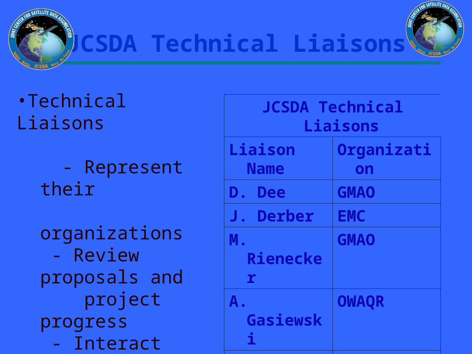
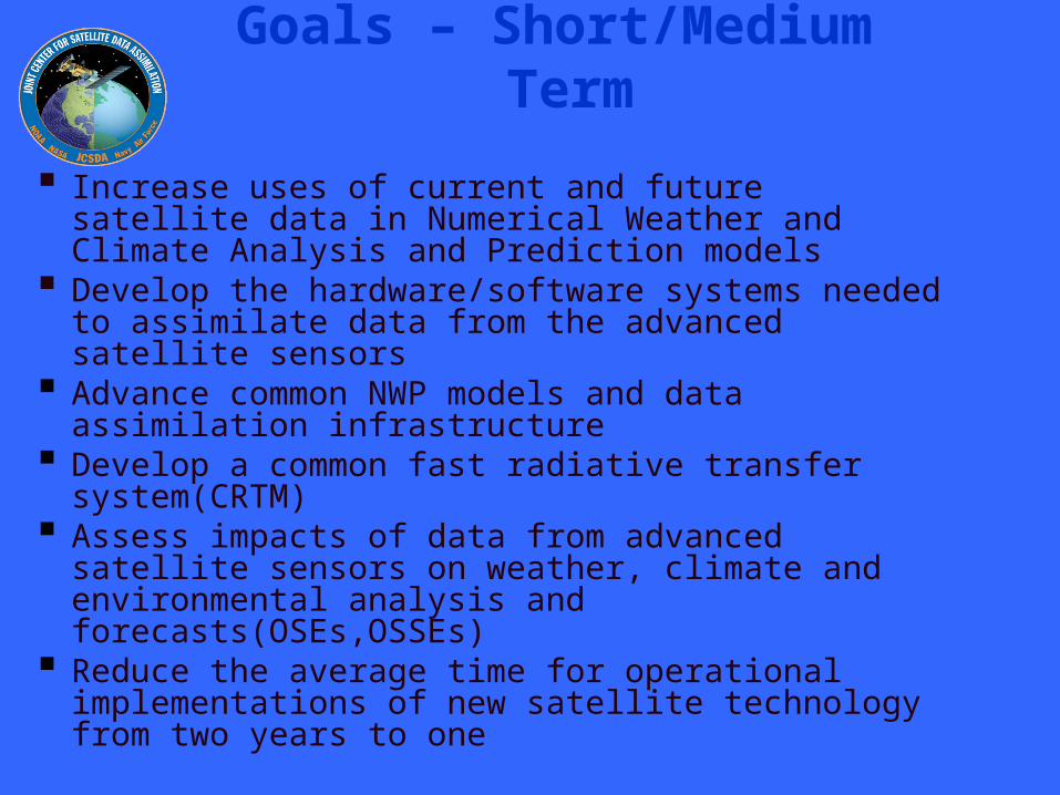
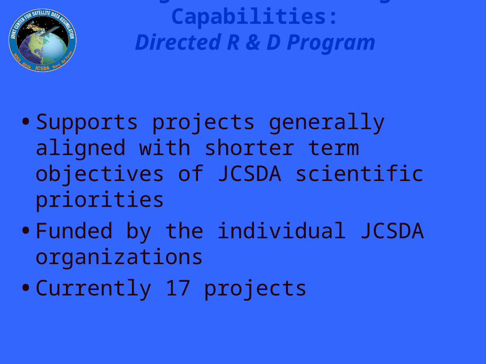
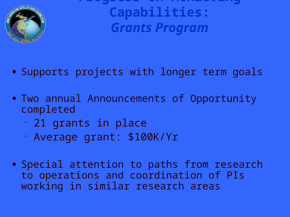
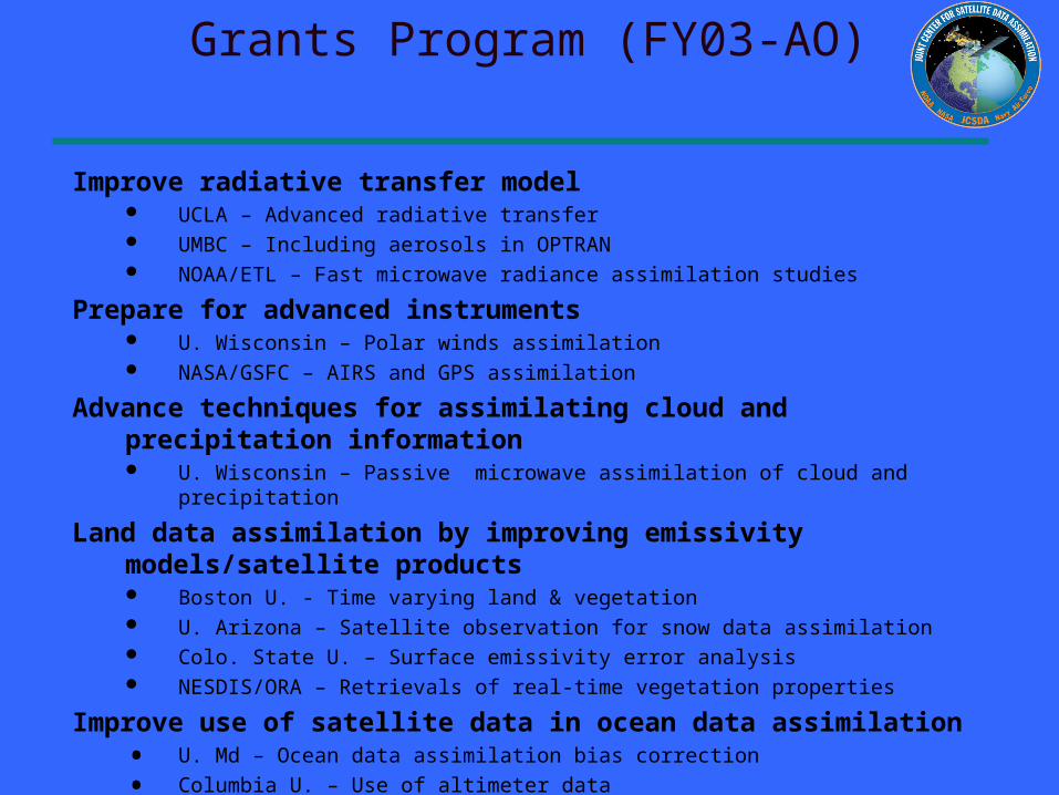
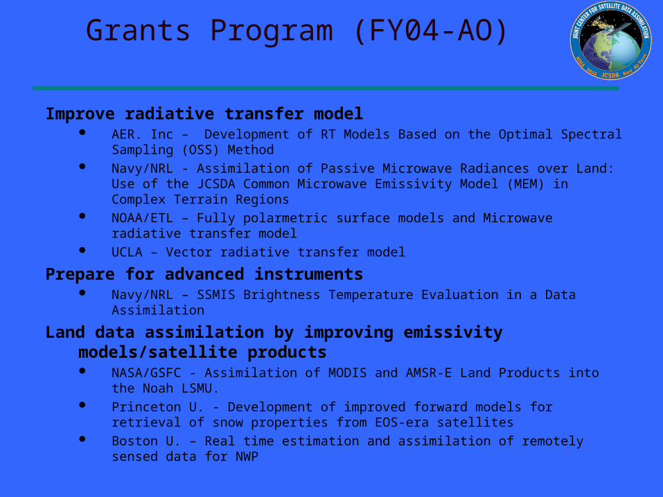
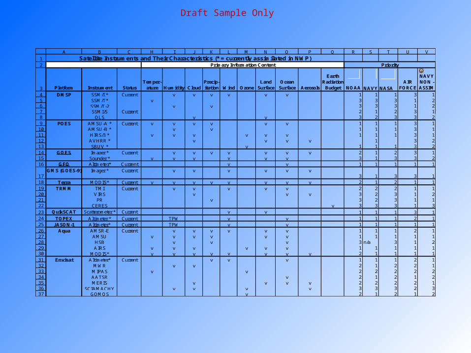
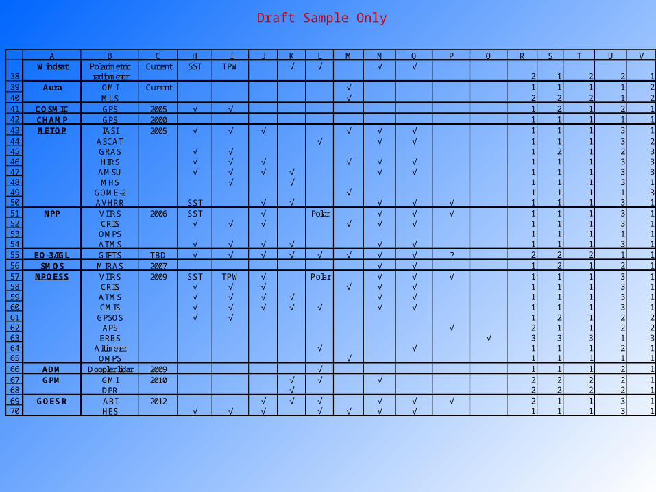
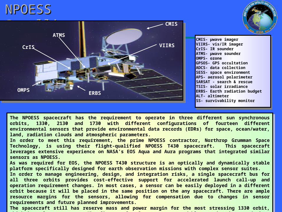
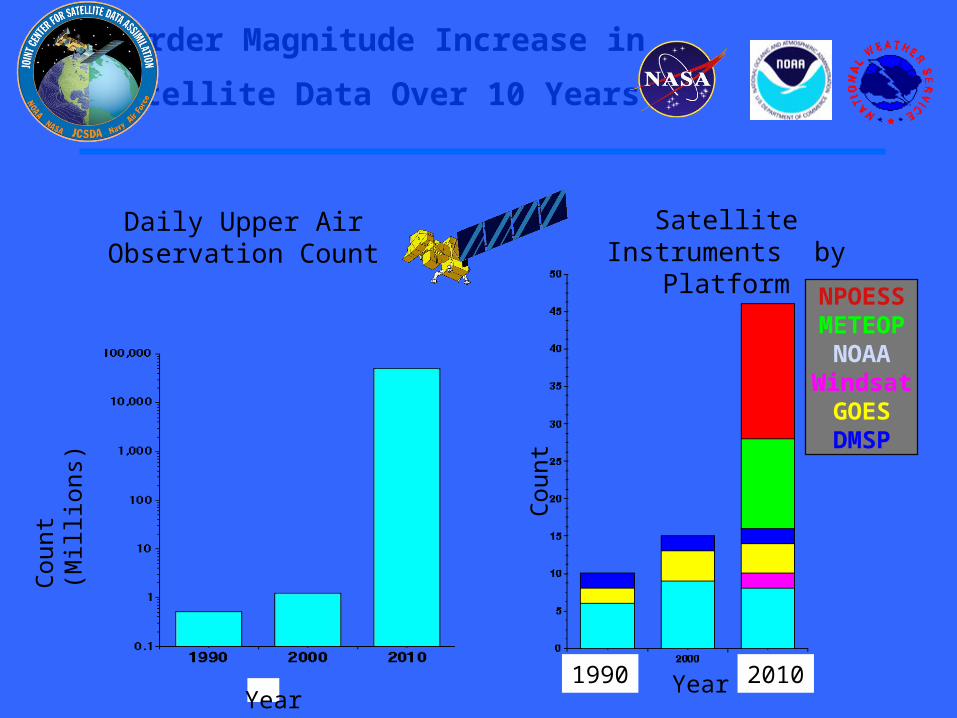
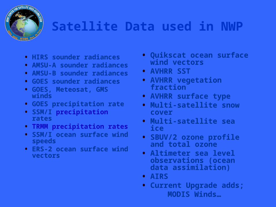
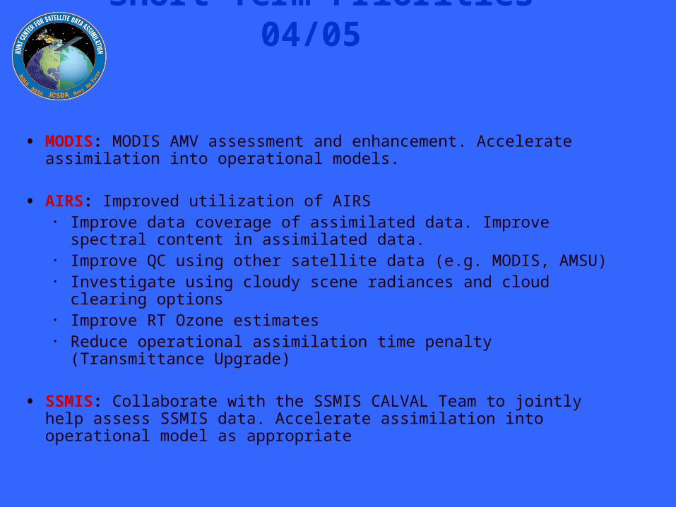
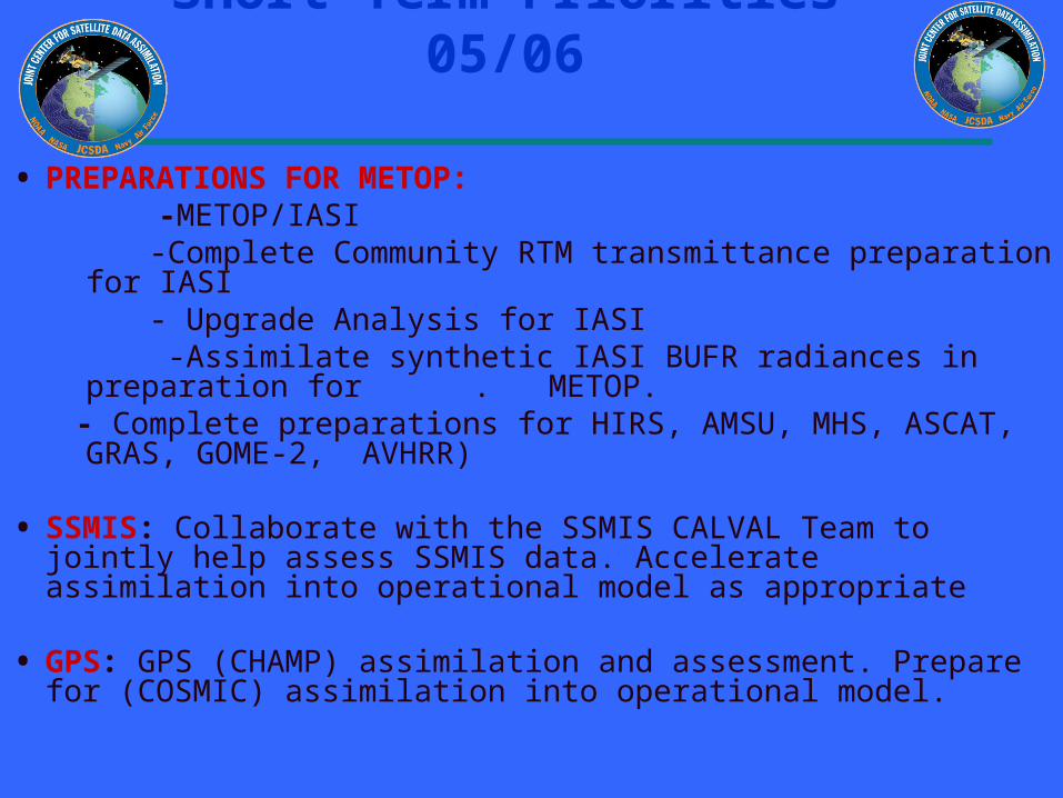
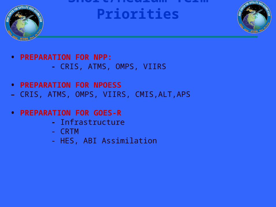

0
005
01
015
02
025
03
035
04
1 201 401 601 801 1001 1201 1401 1601 1801 2001 2201
AIRS channel num ber
RM
S d
iffe
ren
ce
(K
)
0
005
01
015
02
025
03
035
04
1 201 401 601 801 1001 1201 1401 1601 1801 2001 2201
AIRS channel number
rms
(K)
OPTRAN-V7 vs OSS at AIRS channels
OSS
OPTRAN
SSMIS Brightness Temperature Evaluation in a Data Assimilation Context
Summary of Accomplishments bull Worked closely with CalVal team to understand
assimilation implications of the sensor design and calibration anomalies and to devise techniques to mitigate the calibration issues
bull Completed code to read process and quality control observations apply scan non-uniformity and spillover corrections perform beam cell averaging of footprints and compute innovations and associated statistics
bull Developed flexible interface to pCRTM and RTTOV-7
bull Initial results indicate that pCRTM is performing well
Collaborators NRL Nancy Baker (PI) Clay Blankenship Bill Campbell Contributors Steve Swadley (METOC Consulting) Gene Poe (NRL)
Future Real time monitoring of SSMIS TBs Compare pCRTM with RTTOV-7 Assess observation and forward model bias and errors determine useful bias predictors Assess forecast impact of SSMIS assimilation
Reflector in Earth or SC shadow
Warm load intrusions
Reflector in sunlight
OB-BK full resolution (180 scene) TBs
ChanpCRTM
Bias
pCRTM
sd
RTTOV-7
Bias
RTTOV-7
sd
4 170 054 168 053
5 159 100 164 097
6 181 124 183 124
7 353 134 355 144
Figure 4 Impact of sea ice and snow emissivity models on the GFS 24 hr fcst at 850hPa (1 Jan ndash 15 Feb 2004) the pink curve shows theACC with new snow and sea ice emissivity models
Figure 7 Impact of MODIS AMVs on the operational GFS forecast at 500hPa (60degN - 90degN) (10 Aug ndash 23 Sept 2004) the pink (dashed) curve shows the ACC with (without) MODIS AMVs
N Hemisphere 850 mb AC Z 60N - 90N Waves 1-2010 Aug - 23 Sep 04
075
08
085
09
095
1
0 1 2 3 4 5
Forecast [days]
An
om
aly
Co
rre
lati
on
Control
Cntl+MODIS
Hyperspectral Data
Assimilation
AQUA
AIRS data coverage at 06 UTC on 31 January 2004 (Obs-Calc Brightness Temperatures at 6618 cm-1are shown)
Figure 5Spectral locations for 324 AIRS thinned channel data distributed to NWP centers
Table 2 AIRS Data Usage per Six Hourly Analysis Cycle
Data CategoryNumber of AIRS Channels
Total Data Input to AnalysisData Selected for Possible UseData Used in 3D VAR Analysis(Clear Radiances)
~200x106 radiances (channels) ~21x106 radiances (channels)~085x106 radiances (channels)
Figure1(a) 1000hPa Anomaly Correlations for the GFS with (Ops+AIRS) and without (Ops) AIRS data Southern hemisphere January 2004
S Hemisphere 1000 mb AC Z 20S - 80S Waves 1-20
1 Jan - 27 Jan 04
06
065
07
075
08
085
09
095
1
0 1 2 3 4 5 6 7
Forecast [days]
An
om
aly
Co
rrel
atio
n
Ops
Ops+AIRS
Figure 1(b) 500hPa Z Anomaly Correlations for the GFS with (Ops+AIRS) and without (Ops) AIRS data Southern hemisphere January 2004
S Hemisphere 500mb AC Z 20S - 80S Waves 1-20
1 Jan - 27 Jan 04
06
065
07
075
08
085
09
095
1
0 1 2 3 4 5 6 7
Forecast [days]
An
om
aly
Co
rrel
atio
n
Ops
Ops+AIRS
Figure 2 500hPa Z Anomaly Correlations 5 Day Forecast for the GFS with (Ops+AIRS) and without (Ops) AIRS data Southern hemisphere (1-27) January 2004
500 mb Anomaly Correlation Southern Hemisphere
5 Day Fcst
045
055
065
075
085
095
2 4 6 8 10 12 14 16 18 20 22
Day
An
om
aly
Co
rrel
atio
n
Ops
Ops+AIRS
Figure3(a) 1000hPa Anomaly Correlations for the GFS with (Ops+AIRS) and without (Ops) AIRS data Northern hemisphere January 2004
N Hemisphere 1000 mb AC Z 20N - 80N Waves 1-20
1 Jan - 27 Jan 04
06
065
07
075
08
085
09
095
1
0 1 2 3 4 5 6 7
Forecast [days]
An
om
aly
Co
rrel
atio
n
Ops
Ops+AIRS
Figure 3(b) 500hPa Z Anomaly Correlations for the GFS with (Ops+AIRS) and without (Ops) AIRS data Northern hemisphere January 2004
N Hemisphere 500 mb AC Z 20N - 80N Waves 1-20
1 Jan - 27 Jan 04
06
065
07
075
08
085
09
095
1
0 1 2 3 4 5 6 7
Forecast [days]
An
om
aly
Co
rrel
atio
n
Ops
Ops+AIRS
Improved NCEP SST AnalysisXu Li John Derber
EMCNCEP
Project Objective
To Improve SST Analysis
Use satellite data more effectively
Resolve diurnal variation
Improve first guess
Improved NCEP SST AnalysisXu Li John Derber
EMCNCEP Progress
SST physical retrieval code has been merged into GSI and provided to NCEP marine branch for test in operational mode
An extensive diagnostic study on the diurnal variation signals in in situ and satellite observations SST retrievals SST analysis and associated air-sea fluxes (NCEP GFS product) shows the SST diurnal variation needs to be addressed to improve the SST analysis product
7-day 6-hourly SST analysis has been produced with GSI after a new analysis variable in situ and AVHRR data were introduced into GSI
Plan Analyze SST by assimilating satellite radiances directly
with GSI Active ocean in the GFS Aerosol effects
NCEP Operational RTG Daily Analysis GSI Analysis (Daily Mean of 4 6-h analysis)
GSI (00Z ndash Daily Mean) GSI (12Z ndash Daily Mean)
SST Analysis with GSI Diurnal Variation signal and comparison with RTG Analysis04072005 (7th day of GSI SST analysis)
NCEP Operational RTG Daily Analysis GSI Analysis (Daily Mean of 4 6-h analysis)
GSI (00Z ndash Daily Mean) GSI (12Z ndash Daily Mean)
SST Analysis with GSI Diurnal Variation signal and comparison with RTG Analysis04072005 (7th day of GSI SST analysis)
JCSDA Ocean Data Assimilation
JCSDA partners - ocean analysesJCSDA partners - ocean analyses
bullNASAGMAO - seasonal climate forecastsNASAGMAO - seasonal climate forecasts
bullNCEPEMC Ocean and seasonal climate forecastsNCEPEMC Ocean and seasonal climate forecasts
bull Navy - ocean weather forecastsNavy - ocean weather forecasts
bull SST - Key intersection with Meteorology colleaguesSST - Key intersection with Meteorology colleagues
Key contributions sought in JCSDA collaborationsKey contributions sought in JCSDA collaborations
bull improved SSTbull improved surface forcingbull improved error covariances for surface forcing (particularly winds) bull improved observational error covariances (particularly altimetry) including representation error
bull improved ocean data assimilation methodology
The Global Ocean Data Assimilation System (GODAS) at NCEP
bull The primary purpose of the GODAS is to provide a global ocean analysis to initialize the NCEP Coupled Forecast System (CFS) for seasonal to interannual prediction
bull The GODAS is built on the GFDL Modular Ocean Model (MOMv3) and a 3D variational assimilation scheme
bull The GODAS has been operational since 2003 and the CFS since 2004
bull The following slide puts the GODAS in context
Seasonal to Interannual Forecasting at NCEP
Global OceanData AssimilationSystem (GODAS)
Coupled OceanAtmosphere Forecast
System (CFS03)
SST XBT TAO
Altimeter Argo
Scatterometer
Stress
E-P
Heat Fluxes
SST Anomaly Surface Temperatureamp Rainfall Anomalies
Official SST ForecastOfficial ProbabilisticSurface Temperatureamp Rainfall Forecasts
Seasonal Forecastsfor North America
with ClimateAtmosphere GCM
CCA CAMarkov
CCA OCNMR ENSO
Forecasters
Ocean Initial Conditions
IRI
IRI
The Global Ocean Data Assimilation System (GODAS) at NCEP
bull The operational version of GODAS assimilates temperature profiles and synthetic salinity profiles based on the temperature profile and a local climatological TS-relationship
bull Over most the past 25 years the number of available profiles has varied between 5000 and 6000 per month but within the last year the number has increased to more than 7000 per month as the Argo network fills in
bull The following slide illustrates the changing distribution of temperature profiles The most significant events in this regard have been the advent of the equatorial Pacific TAO moorings in the early 1990s and the growth of the Argo float network in the last few years
+ XBT + TAO + Argo
NCEPHYCOM dynamical model(Ocean Forecasting)
bull1048698 Sub-grid scale parameterizations
bullVertical and horizontal eddy viscosity and mixing Diapycnal mixing
bull1048698 Tide and sea surface pressure
bull1048698 River outflow and run-off
bull1048698 Primitive equation with free surface
bull1048698 Ice dynamics and thermodynamics
Central Setup Specifications
bullDynamical Model HYCOM 2013+ GISSbull[FCT-2] In-house adaptations for tidebullriver outflow ice model
bullInitialization Cold Start coastaldeepbullclimatologies followed by assimilationbullof historical data
bullSurface forcing GFS (NCEP) amp MODISbull(water type)
Central Setup 3
bullAssimilation Scheme Multi-variate 2D OIbullamp 2DVar with vertical extension
bullData Types SST SSH in-situ TS icebullConcentration
bullExtensions Prepare (T(z)S(z)) profilesbullfrom T(z) and SSHA
bullCovariance error Decomposed 3D tobull2DX1D
North Atlantic experiments andsetups in NCEP orthogonal
bull sigma2 25 levels
bull112 deg Initialization and assimilationbullResponse to a hurricane
bull13 deg Calibration of atmospheric forcing
bullSeasonal mixed layer variability
bullCalibration of tides
bull112 deg end-to-end operational system in trial
JCSDA Ocean Data Assimilation
bull Improved SST analysis (Xu Li and John Derber NCEPEMC)
bull Detection and correction of aerosol contamination in infrared SST retrievals (Jim Cummings NRLMonterey Andrew Harris NESDIS)
bull Ocean emissivityreflectance model (N Nalli NESDIS JCSDI)
bull Improving analysis of tropical upper ocean conditions for forecasting (Jim Carton)
bull Errors in sea level height analyses (Alexey Kaplan LDEO)
Improved NCEP SST AnalysisXu Li John Derber
EMCNCEP
Project Objective
To Improve SST Analysis
Use satellite data more effectively
Resolve diurnal variation
Improve first guess
Improved NCEP SST AnalysisXu Li John Derber
EMCNCEP Progress
SST physical retrieval code has been merged into GSI and provided to NCEP marine branch for test in operational mode
An extensive diagnostic study on the diurnal variation signals in in situ and satellite observations SST retrievals SST analysis and associated air-sea fluxes (NCEP GFS product) shows the SST diurnal variation needs to be addressed to improve the SST analysis product
7-day 6-hourly SST analysis has been produced with GSI after a new analysis variable in situ and AVHRR data were introduced into GSI
Plan Analyze SST by assimilating satellite radiances directly
with GSI Active ocean in the GFS Aerosol effects
NCEP Operational RTG Daily Analysis GSI Analysis (Daily Mean of 4 6-h analysis)
GSI (00Z ndash Daily Mean) GSI (12Z ndash Daily Mean)
SST Analysis with GSI Diurnal Variation signal and comparison with RTG Analysis04072005 (7th day of GSI SST analysis)
NCEP Operational RTG Daily Analysis GSI Analysis (Daily Mean of 4 6-h analysis)
GSI (00Z ndash Daily Mean) GSI (12Z ndash Daily Mean)
SST Analysis with GSI Diurnal Variation signal and comparison with RTG Analysis04072005 (7th day of GSI SST analysis)
Detection and correction of aerosol contamination in infrared seas surface temperature retrievals
Contributors NRL Jim Cummings (PI) Doug Westphal (PI) Jeff Hawkins NAVO Doug May UMD Andy Harris
bull Detection of aerosol contamination in infrared satellite sea surface temperature (SST) retrievals using Navy Aerosol Analysis Prediction System (NAAPS) aerosol distributions
bull Correction of satellite SSTs for aerosol contamination using NAAPS aerosol products
Project Objectives
Project TasksProject Tasks
bull Collocate NAAPS optical depth forecast fields valid for the time SST retrievals are generated (Doug May NAVOCEANO)
bull Estimate SST retrieval reliability relationship to AOD content (Doug May NAVOCEANO - Jim Cummings NRL)
bull Develop SST quality control schemes to recognize aerosol contamination (Jim Cummings NRL)
bull Correct satellite SSTs for aerosol contamination (Andy Harris NESDIS)
bull Validate NAAPS aerosol products using using independent data - improve NAAPS model (Jeff Hawkins Doug Westphal NRL)
JCSDA Workshop onSatellite Data Assimilation
Detection and correction of aerosol contamination in infrared seas surface temperature retrievals
Summary of Accomplishments
bull Collocation of NAVO AVHRR SSTs and NAAPS aerosol AODs for each aerosol type 4 times daily
bull Development of discriminant QC function to identify possible aerosol contamination
bull Validation of NAAPS AODs for select Saharan dust events using MODIS AOD retrievals
bull Development of reduced predictor scheme which improves correction of satellite BTs by at least a factor 3 over AOD alone
Contributors NRL Jim Cummings (PI) Doug Westphal (PI) Jeff Hawkins NAVO Doug May UMD Andy Harris
Future - Test correction scheme against aerosol-independent (eg MW) SST Use independent data to improve NAAPS product
NAAPS
01 04 16 64
MODIS
Point-for-point comparison in case study shows bi-modal distribution of bias
Addition of total clear-sky transmittance and air-sea T predictors improves BT correction
37 microm 11 microm 12 microm
Suggested form of k-estimation
ASAS
ASAS
ASAS
TTcTTccc
TTbTTbbb
TTaTTaaa
12321210
11321110
73327310
k
k-coefficients will be different for different aerosol types
Ocean Surface Reflection Ocean Surface Reflection Emissivity ModelEmissivity Model
Nicholas R NalliNicholas R Nalli
andand
Chris Barnet Walter Wolf Mitch Goldberg (Co-Is)Chris Barnet Walter Wolf Mitch Goldberg (Co-Is)
NOAANESDISORANOAANESDISORA
Paul van Delst John Derber (EMC POC)Paul van Delst John Derber (EMC POC)
NOAANCEPEMCNOAANCEPEMC
JSDIJSDI - FY05FY05
Enhancement of Ocean ReflectionEmissivity Enhancement of Ocean ReflectionEmissivity ModelModel
ContributorsContributors
ORA Nicholas Nalli (PI) C Barnet W Wolf M ORA Nicholas Nalli (PI) C Barnet W Wolf M GoldbergGoldberg
EMC P van Delst J DerberEMC P van Delst J Derber
Summary of AccomplishmentsSummary of Accomplishmentsbull Theoretical development of quasi-specular Theoretical development of quasi-specular
reflection model in earlier work (Nalli et al reflection model in earlier work (Nalli et al 2001)2001)
bull Sample M-AERI spectra collected from Sample M-AERI spectra collected from AEROSE 2004 to be published in AEROSE 2004 to be published in JGRJGR Special Issue on AIRS validation (Nalli et Special Issue on AIRS validation (Nalli et al 2005) ndash these data will be used to al 2005) ndash these data will be used to verify and validate modelsverify and validate models
bull UMBC Kcarta installed and compiled on UMBC Kcarta installed and compiled on Linux workstationLinux workstation
M-AERI Brightness Temperatures AEROSE 06-M-AERI Brightness Temperatures AEROSE 06-Mar-04Mar-04
From Nalli et al (2005)
FutureFuturebull Conduct statistical analyses of M-AERI field data to verifyquantify model errorConduct statistical analyses of M-AERI field data to verifyquantify model errorbull Characterize window channel spectral response functions and centroid Planck approximationsCharacterize window channel spectral response functions and centroid Planck approximationsbull Run forward radiance calculations for window channels over range of wind speeds zenith angles and atmospheric conditionsRun forward radiance calculations for window channels over range of wind speeds zenith angles and atmospheric conditionsbull Derive lookup tables andor parametric fit of reflection diffusivity angle designed to be used in conjunction with the Wu-Smith Derive lookup tables andor parametric fit of reflection diffusivity angle designed to be used in conjunction with the Wu-Smith
emissivity model currently implemented by NCEPEMCemissivity model currently implemented by NCEPEMCbull Validate model calculations against M-AERI spectra acquired during oceanographic field campaigns including AEROSE 2004Validate model calculations against M-AERI spectra acquired during oceanographic field campaigns including AEROSE 2004bull Tech transfer to NCEPEMC for operational implementation into CRTMTech transfer to NCEPEMC for operational implementation into CRTMbull Implementation within AIRS forward modelImplementation within AIRS forward model
Ocean Surface IR Emissivity Ocean Surface IR Emissivity and Reflectanceand Reflectancebull Radiance emissivity models (eg Masuda et al 1988 Radiance emissivity models (eg Masuda et al 1988
Watts et al 1996 Wu and Smith 1997) have been derived Watts et al 1996 Wu and Smith 1997) have been derived from Cox-Munk wave slope statisticsfrom Cox-Munk wave slope statistics
bull Lookup tables (LUT) of model emissivity are used in Lookup tables (LUT) of model emissivity are used in radiative transfer modeling radiative transfer modeling
bull Reflectance of atmospheric radiance is a more challenging Reflectance of atmospheric radiance is a more challenging problemproblemndash Surface is neither specular nor Lambertian but Surface is neither specular nor Lambertian but quasi-quasi-
specularspecularndash Depends upon the hemispherical radiance distributionDepends upon the hemispherical radiance distributionndash Using 1 Using 1 may lead to systematic errors of forward radiance may lead to systematic errors of forward radiance
in window channelsin window channelsndash These errors may be significant for applications requiring high These errors may be significant for applications requiring high
accuracy (eg SST)accuracy (eg SST)
)(1 0 Vf
Improved Analysis of Tropical Upper Ocean Conditions for Seasonal to Interannual Forecasting
Contributors UMD Jim Carton (PI) Gennady Chepurin EMC David Behringer
Collaborators Hailong Liu Ching-Yee Chang Sumant Nigam
Project Objectives
Identify the forecast bias in the current NCEP ocean assimilation system (GODAS) and explore methods to control its impact on forecasts
Observations have spatially correlated errors while ocean models have slowly varying biases Most current data assimilation schemes assume zero bias
Improved Analysis of Tropical Upper Ocean Conditions for Seasonal to Interannual Forecasting
faTfa
aTa
1f
1
a
P
ˆHQˆH
2
1)(J
Summary of Accomplishments
bull Identification of time mean and seasonal bias in ocean data assimilation
bull Development and coding of reduced space two-stage bias correction algorithm
bull Examination of systematic errors in seasonal cycle of CFS
Contributors UMD Jim Carton (PI) Gennady Chepurin EMC David Behringer
Collaborators Hailong Liu Ching-Yee Chang Sumant Nigam
Future - implementation and extension to multivariate Exploration of seasonal bias in CFS
Reduced-space bias correction
Where the bias is projected on our model EOFs G
Bias stationarity seasonality suggests a simple forecast bias model
95m temp b ias
Bias in temperature annual cycle
95m Temperature bias EOF decomposition
Sea level height errors in models and dataMonte Carlo simulations and spectral distributions
Contributors LDEO AKaplan (PI) MCane (co-PI) TMerlis
Collaborators GMAO ABorovikov MRienecker CKeppenne
Project goal to provide realistic initializations for ocean components of seasonal-to-interannual climate forecast systems by assimilating satellite observations
To achieve this goal we have to investigate the errors of observational and model data sets and the ways to model them statistically
Dynamical simulations of the ocean model error are still quite rare (CaneMillerKaplan et al Fukumori et al Borovikov et al 2005)
Sea level height errors in models and dataMonte Carlo simulations and spectral distributions
Summary of Accomplishmentsbull The AMIP-based ocean ensemble from GMAO
(Borovikov et al 2005) was analyzed and evaluated vs ensembles driven by small-scale noise
bull Ratios of temporal and spatial contributions to the small-scale sea surface height variability were analyzed and used for modeling observational error in monthly tide gauge sea level values wavenumber spectra are used for satellite altimetry error estimates with regards to the model grid size
Contributors LDEO AKaplan (PI) MCane (co-PI) TMerlis
Collaborators GMAO ABorovikov MRienecker CKeppenne
Future Finalizing error estimates ensembles of ocean simulations perturbed by small-scale variability data assimilation implementations
Latitudinal dependence of time evolution of normalized spread in sea surface height for the GMAO ensemble
Theoretical estimatesfor tide gauge error show goodconsistency with the actual errors for all tropical Pacific tide gauge stations but four (known to manifest local effects or phase shifts of Rossby waves)
Summary
From the workshopbull A lot of good progress
bull Collaborations on SST use of aerosol data - collaboration with Clark Weaver (and A da Silva) on aerosol productsinclude emissivityreflectance model in forward model in NCEP radiance assimilation include ocean mixed layer model (Li Harris Rienecker)
bull Collaborations on Assimilation methodology bias estimation (Carton Keppenne) methods to assimilate altimetry - noise models (Kaplan GMAO) ensemble generation (Kaplan GMAO)
Summary
bull Oceanic satellite data assimilation is one of JCSDArsquos mandates
bullSeveral Directed RampD and AO projects supported
bullInfrastructure issues to be addressed
bullKey advances already made
bullCoastalCoral Reef area a clear area for development
Prologue
bull JCSDA is well positioned to exploit the observational data base to be provided by the GOSGEOSS in terms of
bull Assimilation sciencebull Modeling sciencebull Computing power
Generally the next decade of the environmental satellite program promises to be every bit as exciting as the first given the opportunities provided by new observations modern data assimilation techniques improving environmental modeling capacity and burgeoning computer power
The Joint Center will play a key role in enabling the use of advanced satellite data from both current and future advanced systems for environmental modeling
USA Inc and the Global Community will be significant beneficiaries from the Centers activity
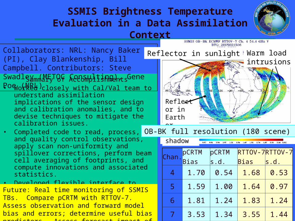
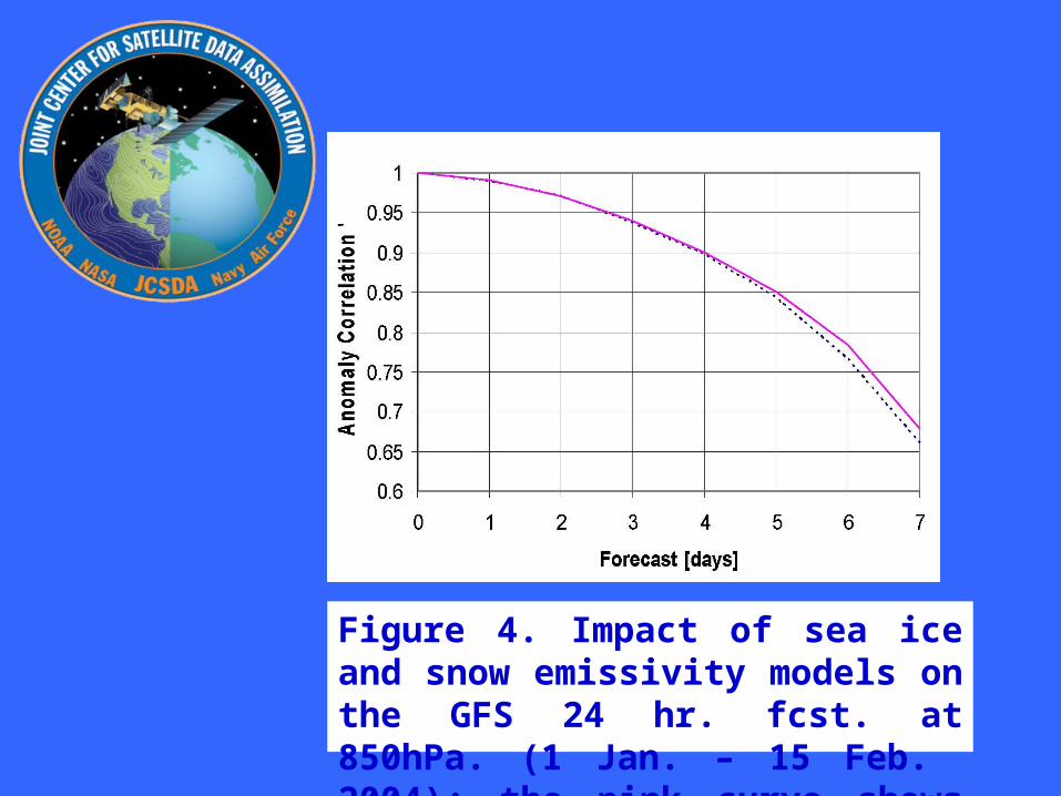
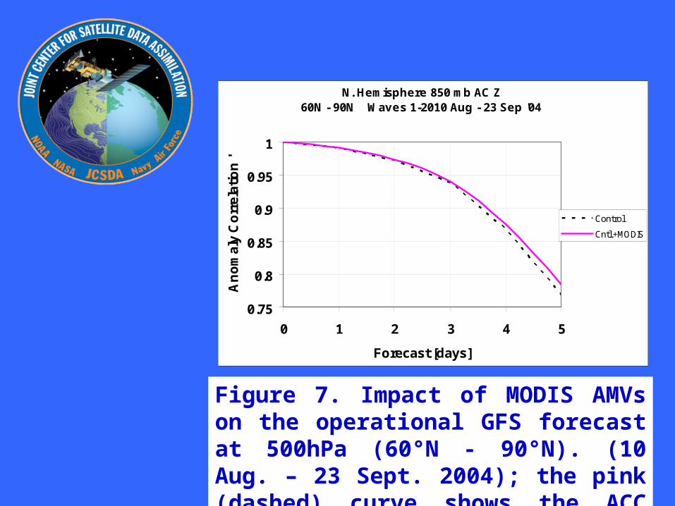
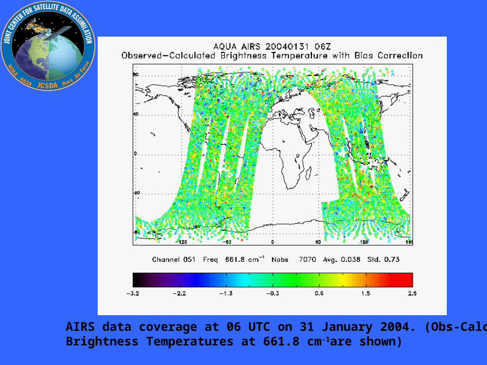
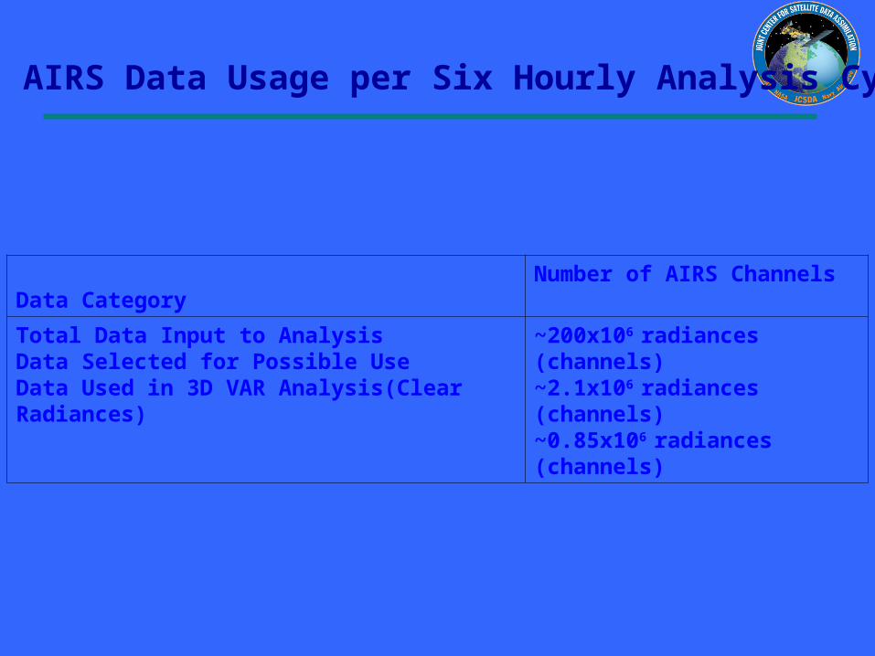
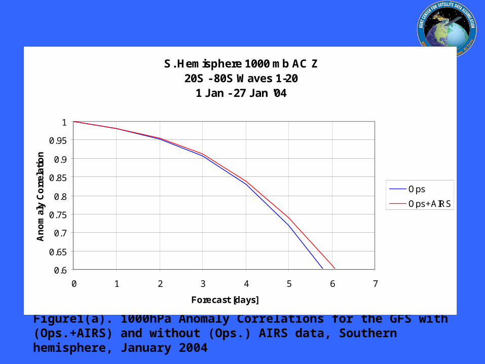
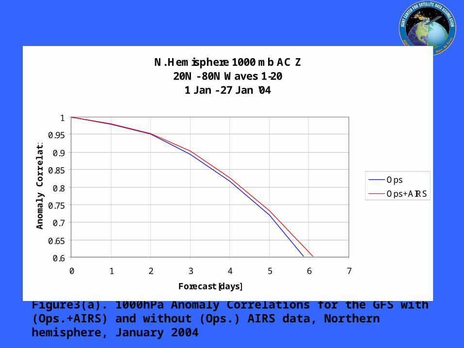

Improved NCEP SST AnalysisXu Li John Derber
EMCNCEP
Project Objective
To Improve SST Analysis
Use satellite data more effectively
Resolve diurnal variation
Improve first guess
Improved NCEP SST AnalysisXu Li John Derber
EMCNCEP Progress
SST physical retrieval code has been merged into GSI and provided to NCEP marine branch for test in operational mode
An extensive diagnostic study on the diurnal variation signals in in situ and satellite observations SST retrievals SST analysis and associated air-sea fluxes (NCEP GFS product) shows the SST diurnal variation needs to be addressed to improve the SST analysis product
7-day 6-hourly SST analysis has been produced with GSI after a new analysis variable in situ and AVHRR data were introduced into GSI
Plan Analyze SST by assimilating satellite radiances directly
with GSI Active ocean in the GFS Aerosol effects
NCEP Operational RTG Daily Analysis GSI Analysis (Daily Mean of 4 6-h analysis)
GSI (00Z ndash Daily Mean) GSI (12Z ndash Daily Mean)
SST Analysis with GSI Diurnal Variation signal and comparison with RTG Analysis04072005 (7th day of GSI SST analysis)
NCEP Operational RTG Daily Analysis GSI Analysis (Daily Mean of 4 6-h analysis)
GSI (00Z ndash Daily Mean) GSI (12Z ndash Daily Mean)
SST Analysis with GSI Diurnal Variation signal and comparison with RTG Analysis04072005 (7th day of GSI SST analysis)
JCSDA Ocean Data Assimilation
JCSDA partners - ocean analysesJCSDA partners - ocean analyses
bullNASAGMAO - seasonal climate forecastsNASAGMAO - seasonal climate forecasts
bullNCEPEMC Ocean and seasonal climate forecastsNCEPEMC Ocean and seasonal climate forecasts
bull Navy - ocean weather forecastsNavy - ocean weather forecasts
bull SST - Key intersection with Meteorology colleaguesSST - Key intersection with Meteorology colleagues
Key contributions sought in JCSDA collaborationsKey contributions sought in JCSDA collaborations
bull improved SSTbull improved surface forcingbull improved error covariances for surface forcing (particularly winds) bull improved observational error covariances (particularly altimetry) including representation error
bull improved ocean data assimilation methodology
The Global Ocean Data Assimilation System (GODAS) at NCEP
bull The primary purpose of the GODAS is to provide a global ocean analysis to initialize the NCEP Coupled Forecast System (CFS) for seasonal to interannual prediction
bull The GODAS is built on the GFDL Modular Ocean Model (MOMv3) and a 3D variational assimilation scheme
bull The GODAS has been operational since 2003 and the CFS since 2004
bull The following slide puts the GODAS in context
Seasonal to Interannual Forecasting at NCEP
Global OceanData AssimilationSystem (GODAS)
Coupled OceanAtmosphere Forecast
System (CFS03)
SST XBT TAO
Altimeter Argo
Scatterometer
Stress
E-P
Heat Fluxes
SST Anomaly Surface Temperatureamp Rainfall Anomalies
Official SST ForecastOfficial ProbabilisticSurface Temperatureamp Rainfall Forecasts
Seasonal Forecastsfor North America
with ClimateAtmosphere GCM
CCA CAMarkov
CCA OCNMR ENSO
Forecasters
Ocean Initial Conditions
IRI
IRI
The Global Ocean Data Assimilation System (GODAS) at NCEP
bull The operational version of GODAS assimilates temperature profiles and synthetic salinity profiles based on the temperature profile and a local climatological TS-relationship
bull Over most the past 25 years the number of available profiles has varied between 5000 and 6000 per month but within the last year the number has increased to more than 7000 per month as the Argo network fills in
bull The following slide illustrates the changing distribution of temperature profiles The most significant events in this regard have been the advent of the equatorial Pacific TAO moorings in the early 1990s and the growth of the Argo float network in the last few years
+ XBT + TAO + Argo
NCEPHYCOM dynamical model(Ocean Forecasting)
bull1048698 Sub-grid scale parameterizations
bullVertical and horizontal eddy viscosity and mixing Diapycnal mixing
bull1048698 Tide and sea surface pressure
bull1048698 River outflow and run-off
bull1048698 Primitive equation with free surface
bull1048698 Ice dynamics and thermodynamics
Central Setup Specifications
bullDynamical Model HYCOM 2013+ GISSbull[FCT-2] In-house adaptations for tidebullriver outflow ice model
bullInitialization Cold Start coastaldeepbullclimatologies followed by assimilationbullof historical data
bullSurface forcing GFS (NCEP) amp MODISbull(water type)
Central Setup 3
bullAssimilation Scheme Multi-variate 2D OIbullamp 2DVar with vertical extension
bullData Types SST SSH in-situ TS icebullConcentration
bullExtensions Prepare (T(z)S(z)) profilesbullfrom T(z) and SSHA
bullCovariance error Decomposed 3D tobull2DX1D
North Atlantic experiments andsetups in NCEP orthogonal
bull sigma2 25 levels
bull112 deg Initialization and assimilationbullResponse to a hurricane
bull13 deg Calibration of atmospheric forcing
bullSeasonal mixed layer variability
bullCalibration of tides
bull112 deg end-to-end operational system in trial
JCSDA Ocean Data Assimilation
bull Improved SST analysis (Xu Li and John Derber NCEPEMC)
bull Detection and correction of aerosol contamination in infrared SST retrievals (Jim Cummings NRLMonterey Andrew Harris NESDIS)
bull Ocean emissivityreflectance model (N Nalli NESDIS JCSDI)
bull Improving analysis of tropical upper ocean conditions for forecasting (Jim Carton)
bull Errors in sea level height analyses (Alexey Kaplan LDEO)
Improved NCEP SST AnalysisXu Li John Derber
EMCNCEP
Project Objective
To Improve SST Analysis
Use satellite data more effectively
Resolve diurnal variation
Improve first guess
Improved NCEP SST AnalysisXu Li John Derber
EMCNCEP Progress
SST physical retrieval code has been merged into GSI and provided to NCEP marine branch for test in operational mode
An extensive diagnostic study on the diurnal variation signals in in situ and satellite observations SST retrievals SST analysis and associated air-sea fluxes (NCEP GFS product) shows the SST diurnal variation needs to be addressed to improve the SST analysis product
7-day 6-hourly SST analysis has been produced with GSI after a new analysis variable in situ and AVHRR data were introduced into GSI
Plan Analyze SST by assimilating satellite radiances directly
with GSI Active ocean in the GFS Aerosol effects
NCEP Operational RTG Daily Analysis GSI Analysis (Daily Mean of 4 6-h analysis)
GSI (00Z ndash Daily Mean) GSI (12Z ndash Daily Mean)
SST Analysis with GSI Diurnal Variation signal and comparison with RTG Analysis04072005 (7th day of GSI SST analysis)
NCEP Operational RTG Daily Analysis GSI Analysis (Daily Mean of 4 6-h analysis)
GSI (00Z ndash Daily Mean) GSI (12Z ndash Daily Mean)
SST Analysis with GSI Diurnal Variation signal and comparison with RTG Analysis04072005 (7th day of GSI SST analysis)
Detection and correction of aerosol contamination in infrared seas surface temperature retrievals
Contributors NRL Jim Cummings (PI) Doug Westphal (PI) Jeff Hawkins NAVO Doug May UMD Andy Harris
bull Detection of aerosol contamination in infrared satellite sea surface temperature (SST) retrievals using Navy Aerosol Analysis Prediction System (NAAPS) aerosol distributions
bull Correction of satellite SSTs for aerosol contamination using NAAPS aerosol products
Project Objectives
Project TasksProject Tasks
bull Collocate NAAPS optical depth forecast fields valid for the time SST retrievals are generated (Doug May NAVOCEANO)
bull Estimate SST retrieval reliability relationship to AOD content (Doug May NAVOCEANO - Jim Cummings NRL)
bull Develop SST quality control schemes to recognize aerosol contamination (Jim Cummings NRL)
bull Correct satellite SSTs for aerosol contamination (Andy Harris NESDIS)
bull Validate NAAPS aerosol products using using independent data - improve NAAPS model (Jeff Hawkins Doug Westphal NRL)
JCSDA Workshop onSatellite Data Assimilation
Detection and correction of aerosol contamination in infrared seas surface temperature retrievals
Summary of Accomplishments
bull Collocation of NAVO AVHRR SSTs and NAAPS aerosol AODs for each aerosol type 4 times daily
bull Development of discriminant QC function to identify possible aerosol contamination
bull Validation of NAAPS AODs for select Saharan dust events using MODIS AOD retrievals
bull Development of reduced predictor scheme which improves correction of satellite BTs by at least a factor 3 over AOD alone
Contributors NRL Jim Cummings (PI) Doug Westphal (PI) Jeff Hawkins NAVO Doug May UMD Andy Harris
Future - Test correction scheme against aerosol-independent (eg MW) SST Use independent data to improve NAAPS product
NAAPS
01 04 16 64
MODIS
Point-for-point comparison in case study shows bi-modal distribution of bias
Addition of total clear-sky transmittance and air-sea T predictors improves BT correction
37 microm 11 microm 12 microm
Suggested form of k-estimation
ASAS
ASAS
ASAS
TTcTTccc
TTbTTbbb
TTaTTaaa
12321210
11321110
73327310
k
k-coefficients will be different for different aerosol types
Ocean Surface Reflection Ocean Surface Reflection Emissivity ModelEmissivity Model
Nicholas R NalliNicholas R Nalli
andand
Chris Barnet Walter Wolf Mitch Goldberg (Co-Is)Chris Barnet Walter Wolf Mitch Goldberg (Co-Is)
NOAANESDISORANOAANESDISORA
Paul van Delst John Derber (EMC POC)Paul van Delst John Derber (EMC POC)
NOAANCEPEMCNOAANCEPEMC
JSDIJSDI - FY05FY05
Enhancement of Ocean ReflectionEmissivity Enhancement of Ocean ReflectionEmissivity ModelModel
ContributorsContributors
ORA Nicholas Nalli (PI) C Barnet W Wolf M ORA Nicholas Nalli (PI) C Barnet W Wolf M GoldbergGoldberg
EMC P van Delst J DerberEMC P van Delst J Derber
Summary of AccomplishmentsSummary of Accomplishmentsbull Theoretical development of quasi-specular Theoretical development of quasi-specular
reflection model in earlier work (Nalli et al reflection model in earlier work (Nalli et al 2001)2001)
bull Sample M-AERI spectra collected from Sample M-AERI spectra collected from AEROSE 2004 to be published in AEROSE 2004 to be published in JGRJGR Special Issue on AIRS validation (Nalli et Special Issue on AIRS validation (Nalli et al 2005) ndash these data will be used to al 2005) ndash these data will be used to verify and validate modelsverify and validate models
bull UMBC Kcarta installed and compiled on UMBC Kcarta installed and compiled on Linux workstationLinux workstation
M-AERI Brightness Temperatures AEROSE 06-M-AERI Brightness Temperatures AEROSE 06-Mar-04Mar-04
From Nalli et al (2005)
FutureFuturebull Conduct statistical analyses of M-AERI field data to verifyquantify model errorConduct statistical analyses of M-AERI field data to verifyquantify model errorbull Characterize window channel spectral response functions and centroid Planck approximationsCharacterize window channel spectral response functions and centroid Planck approximationsbull Run forward radiance calculations for window channels over range of wind speeds zenith angles and atmospheric conditionsRun forward radiance calculations for window channels over range of wind speeds zenith angles and atmospheric conditionsbull Derive lookup tables andor parametric fit of reflection diffusivity angle designed to be used in conjunction with the Wu-Smith Derive lookup tables andor parametric fit of reflection diffusivity angle designed to be used in conjunction with the Wu-Smith
emissivity model currently implemented by NCEPEMCemissivity model currently implemented by NCEPEMCbull Validate model calculations against M-AERI spectra acquired during oceanographic field campaigns including AEROSE 2004Validate model calculations against M-AERI spectra acquired during oceanographic field campaigns including AEROSE 2004bull Tech transfer to NCEPEMC for operational implementation into CRTMTech transfer to NCEPEMC for operational implementation into CRTMbull Implementation within AIRS forward modelImplementation within AIRS forward model
Ocean Surface IR Emissivity Ocean Surface IR Emissivity and Reflectanceand Reflectancebull Radiance emissivity models (eg Masuda et al 1988 Radiance emissivity models (eg Masuda et al 1988
Watts et al 1996 Wu and Smith 1997) have been derived Watts et al 1996 Wu and Smith 1997) have been derived from Cox-Munk wave slope statisticsfrom Cox-Munk wave slope statistics
bull Lookup tables (LUT) of model emissivity are used in Lookup tables (LUT) of model emissivity are used in radiative transfer modeling radiative transfer modeling
bull Reflectance of atmospheric radiance is a more challenging Reflectance of atmospheric radiance is a more challenging problemproblemndash Surface is neither specular nor Lambertian but Surface is neither specular nor Lambertian but quasi-quasi-
specularspecularndash Depends upon the hemispherical radiance distributionDepends upon the hemispherical radiance distributionndash Using 1 Using 1 may lead to systematic errors of forward radiance may lead to systematic errors of forward radiance
in window channelsin window channelsndash These errors may be significant for applications requiring high These errors may be significant for applications requiring high
accuracy (eg SST)accuracy (eg SST)
)(1 0 Vf
Improved Analysis of Tropical Upper Ocean Conditions for Seasonal to Interannual Forecasting
Contributors UMD Jim Carton (PI) Gennady Chepurin EMC David Behringer
Collaborators Hailong Liu Ching-Yee Chang Sumant Nigam
Project Objectives
Identify the forecast bias in the current NCEP ocean assimilation system (GODAS) and explore methods to control its impact on forecasts
Observations have spatially correlated errors while ocean models have slowly varying biases Most current data assimilation schemes assume zero bias
Improved Analysis of Tropical Upper Ocean Conditions for Seasonal to Interannual Forecasting
faTfa
aTa
1f
1
a
P
ˆHQˆH
2
1)(J
Summary of Accomplishments
bull Identification of time mean and seasonal bias in ocean data assimilation
bull Development and coding of reduced space two-stage bias correction algorithm
bull Examination of systematic errors in seasonal cycle of CFS
Contributors UMD Jim Carton (PI) Gennady Chepurin EMC David Behringer
Collaborators Hailong Liu Ching-Yee Chang Sumant Nigam
Future - implementation and extension to multivariate Exploration of seasonal bias in CFS
Reduced-space bias correction
Where the bias is projected on our model EOFs G
Bias stationarity seasonality suggests a simple forecast bias model
95m temp b ias
Bias in temperature annual cycle
95m Temperature bias EOF decomposition
Sea level height errors in models and dataMonte Carlo simulations and spectral distributions
Contributors LDEO AKaplan (PI) MCane (co-PI) TMerlis
Collaborators GMAO ABorovikov MRienecker CKeppenne
Project goal to provide realistic initializations for ocean components of seasonal-to-interannual climate forecast systems by assimilating satellite observations
To achieve this goal we have to investigate the errors of observational and model data sets and the ways to model them statistically
Dynamical simulations of the ocean model error are still quite rare (CaneMillerKaplan et al Fukumori et al Borovikov et al 2005)
Sea level height errors in models and dataMonte Carlo simulations and spectral distributions
Summary of Accomplishmentsbull The AMIP-based ocean ensemble from GMAO
(Borovikov et al 2005) was analyzed and evaluated vs ensembles driven by small-scale noise
bull Ratios of temporal and spatial contributions to the small-scale sea surface height variability were analyzed and used for modeling observational error in monthly tide gauge sea level values wavenumber spectra are used for satellite altimetry error estimates with regards to the model grid size
Contributors LDEO AKaplan (PI) MCane (co-PI) TMerlis
Collaborators GMAO ABorovikov MRienecker CKeppenne
Future Finalizing error estimates ensembles of ocean simulations perturbed by small-scale variability data assimilation implementations
Latitudinal dependence of time evolution of normalized spread in sea surface height for the GMAO ensemble
Theoretical estimatesfor tide gauge error show goodconsistency with the actual errors for all tropical Pacific tide gauge stations but four (known to manifest local effects or phase shifts of Rossby waves)
Summary
From the workshopbull A lot of good progress
bull Collaborations on SST use of aerosol data - collaboration with Clark Weaver (and A da Silva) on aerosol productsinclude emissivityreflectance model in forward model in NCEP radiance assimilation include ocean mixed layer model (Li Harris Rienecker)
bull Collaborations on Assimilation methodology bias estimation (Carton Keppenne) methods to assimilate altimetry - noise models (Kaplan GMAO) ensemble generation (Kaplan GMAO)
Summary
bull Oceanic satellite data assimilation is one of JCSDArsquos mandates
bullSeveral Directed RampD and AO projects supported
bullInfrastructure issues to be addressed
bullKey advances already made
bullCoastalCoral Reef area a clear area for development
Prologue
bull JCSDA is well positioned to exploit the observational data base to be provided by the GOSGEOSS in terms of
bull Assimilation sciencebull Modeling sciencebull Computing power
Generally the next decade of the environmental satellite program promises to be every bit as exciting as the first given the opportunities provided by new observations modern data assimilation techniques improving environmental modeling capacity and burgeoning computer power
The Joint Center will play a key role in enabling the use of advanced satellite data from both current and future advanced systems for environmental modeling
USA Inc and the Global Community will be significant beneficiaries from the Centers activity
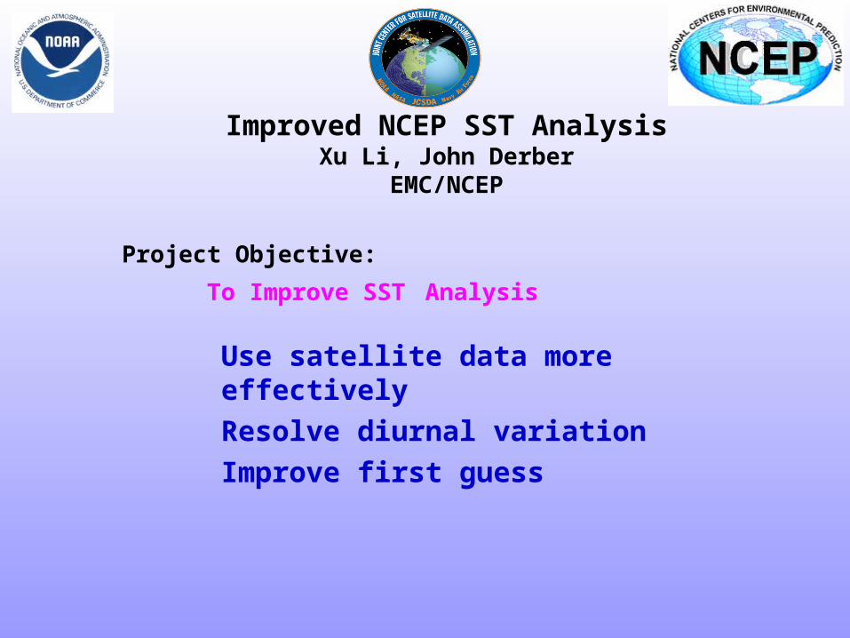
Improved NCEP SST AnalysisXu Li John Derber
EMCNCEP Progress
SST physical retrieval code has been merged into GSI and provided to NCEP marine branch for test in operational mode
An extensive diagnostic study on the diurnal variation signals in in situ and satellite observations SST retrievals SST analysis and associated air-sea fluxes (NCEP GFS product) shows the SST diurnal variation needs to be addressed to improve the SST analysis product
7-day 6-hourly SST analysis has been produced with GSI after a new analysis variable in situ and AVHRR data were introduced into GSI
Plan Analyze SST by assimilating satellite radiances directly
with GSI Active ocean in the GFS Aerosol effects
NCEP Operational RTG Daily Analysis GSI Analysis (Daily Mean of 4 6-h analysis)
GSI (00Z ndash Daily Mean) GSI (12Z ndash Daily Mean)
SST Analysis with GSI Diurnal Variation signal and comparison with RTG Analysis04072005 (7th day of GSI SST analysis)
NCEP Operational RTG Daily Analysis GSI Analysis (Daily Mean of 4 6-h analysis)
GSI (00Z ndash Daily Mean) GSI (12Z ndash Daily Mean)
SST Analysis with GSI Diurnal Variation signal and comparison with RTG Analysis04072005 (7th day of GSI SST analysis)
JCSDA Ocean Data Assimilation
JCSDA partners - ocean analysesJCSDA partners - ocean analyses
bullNASAGMAO - seasonal climate forecastsNASAGMAO - seasonal climate forecasts
bullNCEPEMC Ocean and seasonal climate forecastsNCEPEMC Ocean and seasonal climate forecasts
bull Navy - ocean weather forecastsNavy - ocean weather forecasts
bull SST - Key intersection with Meteorology colleaguesSST - Key intersection with Meteorology colleagues
Key contributions sought in JCSDA collaborationsKey contributions sought in JCSDA collaborations
bull improved SSTbull improved surface forcingbull improved error covariances for surface forcing (particularly winds) bull improved observational error covariances (particularly altimetry) including representation error
bull improved ocean data assimilation methodology
The Global Ocean Data Assimilation System (GODAS) at NCEP
bull The primary purpose of the GODAS is to provide a global ocean analysis to initialize the NCEP Coupled Forecast System (CFS) for seasonal to interannual prediction
bull The GODAS is built on the GFDL Modular Ocean Model (MOMv3) and a 3D variational assimilation scheme
bull The GODAS has been operational since 2003 and the CFS since 2004
bull The following slide puts the GODAS in context
Seasonal to Interannual Forecasting at NCEP
Global OceanData AssimilationSystem (GODAS)
Coupled OceanAtmosphere Forecast
System (CFS03)
SST XBT TAO
Altimeter Argo
Scatterometer
Stress
E-P
Heat Fluxes
SST Anomaly Surface Temperatureamp Rainfall Anomalies
Official SST ForecastOfficial ProbabilisticSurface Temperatureamp Rainfall Forecasts
Seasonal Forecastsfor North America
with ClimateAtmosphere GCM
CCA CAMarkov
CCA OCNMR ENSO
Forecasters
Ocean Initial Conditions
IRI
IRI
The Global Ocean Data Assimilation System (GODAS) at NCEP
bull The operational version of GODAS assimilates temperature profiles and synthetic salinity profiles based on the temperature profile and a local climatological TS-relationship
bull Over most the past 25 years the number of available profiles has varied between 5000 and 6000 per month but within the last year the number has increased to more than 7000 per month as the Argo network fills in
bull The following slide illustrates the changing distribution of temperature profiles The most significant events in this regard have been the advent of the equatorial Pacific TAO moorings in the early 1990s and the growth of the Argo float network in the last few years
+ XBT + TAO + Argo
NCEPHYCOM dynamical model(Ocean Forecasting)
bull1048698 Sub-grid scale parameterizations
bullVertical and horizontal eddy viscosity and mixing Diapycnal mixing
bull1048698 Tide and sea surface pressure
bull1048698 River outflow and run-off
bull1048698 Primitive equation with free surface
bull1048698 Ice dynamics and thermodynamics
Central Setup Specifications
bullDynamical Model HYCOM 2013+ GISSbull[FCT-2] In-house adaptations for tidebullriver outflow ice model
bullInitialization Cold Start coastaldeepbullclimatologies followed by assimilationbullof historical data
bullSurface forcing GFS (NCEP) amp MODISbull(water type)
Central Setup 3
bullAssimilation Scheme Multi-variate 2D OIbullamp 2DVar with vertical extension
bullData Types SST SSH in-situ TS icebullConcentration
bullExtensions Prepare (T(z)S(z)) profilesbullfrom T(z) and SSHA
bullCovariance error Decomposed 3D tobull2DX1D
North Atlantic experiments andsetups in NCEP orthogonal
bull sigma2 25 levels
bull112 deg Initialization and assimilationbullResponse to a hurricane
bull13 deg Calibration of atmospheric forcing
bullSeasonal mixed layer variability
bullCalibration of tides
bull112 deg end-to-end operational system in trial
JCSDA Ocean Data Assimilation
bull Improved SST analysis (Xu Li and John Derber NCEPEMC)
bull Detection and correction of aerosol contamination in infrared SST retrievals (Jim Cummings NRLMonterey Andrew Harris NESDIS)
bull Ocean emissivityreflectance model (N Nalli NESDIS JCSDI)
bull Improving analysis of tropical upper ocean conditions for forecasting (Jim Carton)
bull Errors in sea level height analyses (Alexey Kaplan LDEO)
Improved NCEP SST AnalysisXu Li John Derber
EMCNCEP
Project Objective
To Improve SST Analysis
Use satellite data more effectively
Resolve diurnal variation
Improve first guess
Improved NCEP SST AnalysisXu Li John Derber
EMCNCEP Progress
SST physical retrieval code has been merged into GSI and provided to NCEP marine branch for test in operational mode
An extensive diagnostic study on the diurnal variation signals in in situ and satellite observations SST retrievals SST analysis and associated air-sea fluxes (NCEP GFS product) shows the SST diurnal variation needs to be addressed to improve the SST analysis product
7-day 6-hourly SST analysis has been produced with GSI after a new analysis variable in situ and AVHRR data were introduced into GSI
Plan Analyze SST by assimilating satellite radiances directly
with GSI Active ocean in the GFS Aerosol effects
NCEP Operational RTG Daily Analysis GSI Analysis (Daily Mean of 4 6-h analysis)
GSI (00Z ndash Daily Mean) GSI (12Z ndash Daily Mean)
SST Analysis with GSI Diurnal Variation signal and comparison with RTG Analysis04072005 (7th day of GSI SST analysis)
NCEP Operational RTG Daily Analysis GSI Analysis (Daily Mean of 4 6-h analysis)
GSI (00Z ndash Daily Mean) GSI (12Z ndash Daily Mean)
SST Analysis with GSI Diurnal Variation signal and comparison with RTG Analysis04072005 (7th day of GSI SST analysis)
Detection and correction of aerosol contamination in infrared seas surface temperature retrievals
Contributors NRL Jim Cummings (PI) Doug Westphal (PI) Jeff Hawkins NAVO Doug May UMD Andy Harris
bull Detection of aerosol contamination in infrared satellite sea surface temperature (SST) retrievals using Navy Aerosol Analysis Prediction System (NAAPS) aerosol distributions
bull Correction of satellite SSTs for aerosol contamination using NAAPS aerosol products
Project Objectives
Project TasksProject Tasks
bull Collocate NAAPS optical depth forecast fields valid for the time SST retrievals are generated (Doug May NAVOCEANO)
bull Estimate SST retrieval reliability relationship to AOD content (Doug May NAVOCEANO - Jim Cummings NRL)
bull Develop SST quality control schemes to recognize aerosol contamination (Jim Cummings NRL)
bull Correct satellite SSTs for aerosol contamination (Andy Harris NESDIS)
bull Validate NAAPS aerosol products using using independent data - improve NAAPS model (Jeff Hawkins Doug Westphal NRL)
JCSDA Workshop onSatellite Data Assimilation
Detection and correction of aerosol contamination in infrared seas surface temperature retrievals
Summary of Accomplishments
bull Collocation of NAVO AVHRR SSTs and NAAPS aerosol AODs for each aerosol type 4 times daily
bull Development of discriminant QC function to identify possible aerosol contamination
bull Validation of NAAPS AODs for select Saharan dust events using MODIS AOD retrievals
bull Development of reduced predictor scheme which improves correction of satellite BTs by at least a factor 3 over AOD alone
Contributors NRL Jim Cummings (PI) Doug Westphal (PI) Jeff Hawkins NAVO Doug May UMD Andy Harris
Future - Test correction scheme against aerosol-independent (eg MW) SST Use independent data to improve NAAPS product
NAAPS
01 04 16 64
MODIS
Point-for-point comparison in case study shows bi-modal distribution of bias
Addition of total clear-sky transmittance and air-sea T predictors improves BT correction
37 microm 11 microm 12 microm
Suggested form of k-estimation
ASAS
ASAS
ASAS
TTcTTccc
TTbTTbbb
TTaTTaaa
12321210
11321110
73327310
k
k-coefficients will be different for different aerosol types
Ocean Surface Reflection Ocean Surface Reflection Emissivity ModelEmissivity Model
Nicholas R NalliNicholas R Nalli
andand
Chris Barnet Walter Wolf Mitch Goldberg (Co-Is)Chris Barnet Walter Wolf Mitch Goldberg (Co-Is)
NOAANESDISORANOAANESDISORA
Paul van Delst John Derber (EMC POC)Paul van Delst John Derber (EMC POC)
NOAANCEPEMCNOAANCEPEMC
JSDIJSDI - FY05FY05
Enhancement of Ocean ReflectionEmissivity Enhancement of Ocean ReflectionEmissivity ModelModel
ContributorsContributors
ORA Nicholas Nalli (PI) C Barnet W Wolf M ORA Nicholas Nalli (PI) C Barnet W Wolf M GoldbergGoldberg
EMC P van Delst J DerberEMC P van Delst J Derber
Summary of AccomplishmentsSummary of Accomplishmentsbull Theoretical development of quasi-specular Theoretical development of quasi-specular
reflection model in earlier work (Nalli et al reflection model in earlier work (Nalli et al 2001)2001)
bull Sample M-AERI spectra collected from Sample M-AERI spectra collected from AEROSE 2004 to be published in AEROSE 2004 to be published in JGRJGR Special Issue on AIRS validation (Nalli et Special Issue on AIRS validation (Nalli et al 2005) ndash these data will be used to al 2005) ndash these data will be used to verify and validate modelsverify and validate models
bull UMBC Kcarta installed and compiled on UMBC Kcarta installed and compiled on Linux workstationLinux workstation
M-AERI Brightness Temperatures AEROSE 06-M-AERI Brightness Temperatures AEROSE 06-Mar-04Mar-04
From Nalli et al (2005)
FutureFuturebull Conduct statistical analyses of M-AERI field data to verifyquantify model errorConduct statistical analyses of M-AERI field data to verifyquantify model errorbull Characterize window channel spectral response functions and centroid Planck approximationsCharacterize window channel spectral response functions and centroid Planck approximationsbull Run forward radiance calculations for window channels over range of wind speeds zenith angles and atmospheric conditionsRun forward radiance calculations for window channels over range of wind speeds zenith angles and atmospheric conditionsbull Derive lookup tables andor parametric fit of reflection diffusivity angle designed to be used in conjunction with the Wu-Smith Derive lookup tables andor parametric fit of reflection diffusivity angle designed to be used in conjunction with the Wu-Smith
emissivity model currently implemented by NCEPEMCemissivity model currently implemented by NCEPEMCbull Validate model calculations against M-AERI spectra acquired during oceanographic field campaigns including AEROSE 2004Validate model calculations against M-AERI spectra acquired during oceanographic field campaigns including AEROSE 2004bull Tech transfer to NCEPEMC for operational implementation into CRTMTech transfer to NCEPEMC for operational implementation into CRTMbull Implementation within AIRS forward modelImplementation within AIRS forward model
Ocean Surface IR Emissivity Ocean Surface IR Emissivity and Reflectanceand Reflectancebull Radiance emissivity models (eg Masuda et al 1988 Radiance emissivity models (eg Masuda et al 1988
Watts et al 1996 Wu and Smith 1997) have been derived Watts et al 1996 Wu and Smith 1997) have been derived from Cox-Munk wave slope statisticsfrom Cox-Munk wave slope statistics
bull Lookup tables (LUT) of model emissivity are used in Lookup tables (LUT) of model emissivity are used in radiative transfer modeling radiative transfer modeling
bull Reflectance of atmospheric radiance is a more challenging Reflectance of atmospheric radiance is a more challenging problemproblemndash Surface is neither specular nor Lambertian but Surface is neither specular nor Lambertian but quasi-quasi-
specularspecularndash Depends upon the hemispherical radiance distributionDepends upon the hemispherical radiance distributionndash Using 1 Using 1 may lead to systematic errors of forward radiance may lead to systematic errors of forward radiance
in window channelsin window channelsndash These errors may be significant for applications requiring high These errors may be significant for applications requiring high
accuracy (eg SST)accuracy (eg SST)
)(1 0 Vf
Improved Analysis of Tropical Upper Ocean Conditions for Seasonal to Interannual Forecasting
Contributors UMD Jim Carton (PI) Gennady Chepurin EMC David Behringer
Collaborators Hailong Liu Ching-Yee Chang Sumant Nigam
Project Objectives
Identify the forecast bias in the current NCEP ocean assimilation system (GODAS) and explore methods to control its impact on forecasts
Observations have spatially correlated errors while ocean models have slowly varying biases Most current data assimilation schemes assume zero bias
Improved Analysis of Tropical Upper Ocean Conditions for Seasonal to Interannual Forecasting
faTfa
aTa
1f
1
a
P
ˆHQˆH
2
1)(J
Summary of Accomplishments
bull Identification of time mean and seasonal bias in ocean data assimilation
bull Development and coding of reduced space two-stage bias correction algorithm
bull Examination of systematic errors in seasonal cycle of CFS
Contributors UMD Jim Carton (PI) Gennady Chepurin EMC David Behringer
Collaborators Hailong Liu Ching-Yee Chang Sumant Nigam
Future - implementation and extension to multivariate Exploration of seasonal bias in CFS
Reduced-space bias correction
Where the bias is projected on our model EOFs G
Bias stationarity seasonality suggests a simple forecast bias model
95m temp b ias
Bias in temperature annual cycle
95m Temperature bias EOF decomposition
Sea level height errors in models and dataMonte Carlo simulations and spectral distributions
Contributors LDEO AKaplan (PI) MCane (co-PI) TMerlis
Collaborators GMAO ABorovikov MRienecker CKeppenne
Project goal to provide realistic initializations for ocean components of seasonal-to-interannual climate forecast systems by assimilating satellite observations
To achieve this goal we have to investigate the errors of observational and model data sets and the ways to model them statistically
Dynamical simulations of the ocean model error are still quite rare (CaneMillerKaplan et al Fukumori et al Borovikov et al 2005)
Sea level height errors in models and dataMonte Carlo simulations and spectral distributions
Summary of Accomplishmentsbull The AMIP-based ocean ensemble from GMAO
(Borovikov et al 2005) was analyzed and evaluated vs ensembles driven by small-scale noise
bull Ratios of temporal and spatial contributions to the small-scale sea surface height variability were analyzed and used for modeling observational error in monthly tide gauge sea level values wavenumber spectra are used for satellite altimetry error estimates with regards to the model grid size
Contributors LDEO AKaplan (PI) MCane (co-PI) TMerlis
Collaborators GMAO ABorovikov MRienecker CKeppenne
Future Finalizing error estimates ensembles of ocean simulations perturbed by small-scale variability data assimilation implementations
Latitudinal dependence of time evolution of normalized spread in sea surface height for the GMAO ensemble
Theoretical estimatesfor tide gauge error show goodconsistency with the actual errors for all tropical Pacific tide gauge stations but four (known to manifest local effects or phase shifts of Rossby waves)
Summary
From the workshopbull A lot of good progress
bull Collaborations on SST use of aerosol data - collaboration with Clark Weaver (and A da Silva) on aerosol productsinclude emissivityreflectance model in forward model in NCEP radiance assimilation include ocean mixed layer model (Li Harris Rienecker)
bull Collaborations on Assimilation methodology bias estimation (Carton Keppenne) methods to assimilate altimetry - noise models (Kaplan GMAO) ensemble generation (Kaplan GMAO)
Summary
bull Oceanic satellite data assimilation is one of JCSDArsquos mandates
bullSeveral Directed RampD and AO projects supported
bullInfrastructure issues to be addressed
bullKey advances already made
bullCoastalCoral Reef area a clear area for development
Prologue
bull JCSDA is well positioned to exploit the observational data base to be provided by the GOSGEOSS in terms of
bull Assimilation sciencebull Modeling sciencebull Computing power
Generally the next decade of the environmental satellite program promises to be every bit as exciting as the first given the opportunities provided by new observations modern data assimilation techniques improving environmental modeling capacity and burgeoning computer power
The Joint Center will play a key role in enabling the use of advanced satellite data from both current and future advanced systems for environmental modeling
USA Inc and the Global Community will be significant beneficiaries from the Centers activity
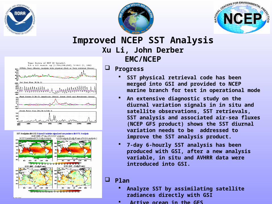
NCEP Operational RTG Daily Analysis GSI Analysis (Daily Mean of 4 6-h analysis)
GSI (00Z ndash Daily Mean) GSI (12Z ndash Daily Mean)
SST Analysis with GSI Diurnal Variation signal and comparison with RTG Analysis04072005 (7th day of GSI SST analysis)
JCSDA Ocean Data Assimilation
JCSDA partners - ocean analysesJCSDA partners - ocean analyses
bullNASAGMAO - seasonal climate forecastsNASAGMAO - seasonal climate forecasts
bullNCEPEMC Ocean and seasonal climate forecastsNCEPEMC Ocean and seasonal climate forecasts
bull Navy - ocean weather forecastsNavy - ocean weather forecasts
bull SST - Key intersection with Meteorology colleaguesSST - Key intersection with Meteorology colleagues
Key contributions sought in JCSDA collaborationsKey contributions sought in JCSDA collaborations
bull improved SSTbull improved surface forcingbull improved error covariances for surface forcing (particularly winds) bull improved observational error covariances (particularly altimetry) including representation error
bull improved ocean data assimilation methodology
The Global Ocean Data Assimilation System (GODAS) at NCEP
bull The primary purpose of the GODAS is to provide a global ocean analysis to initialize the NCEP Coupled Forecast System (CFS) for seasonal to interannual prediction
bull The GODAS is built on the GFDL Modular Ocean Model (MOMv3) and a 3D variational assimilation scheme
bull The GODAS has been operational since 2003 and the CFS since 2004
bull The following slide puts the GODAS in context
Seasonal to Interannual Forecasting at NCEP
Global OceanData AssimilationSystem (GODAS)
Coupled OceanAtmosphere Forecast
System (CFS03)
SST XBT TAO
Altimeter Argo
Scatterometer
Stress
E-P
Heat Fluxes
SST Anomaly Surface Temperatureamp Rainfall Anomalies
Official SST ForecastOfficial ProbabilisticSurface Temperatureamp Rainfall Forecasts
Seasonal Forecastsfor North America
with ClimateAtmosphere GCM
CCA CAMarkov
CCA OCNMR ENSO
Forecasters
Ocean Initial Conditions
IRI
IRI
The Global Ocean Data Assimilation System (GODAS) at NCEP
bull The operational version of GODAS assimilates temperature profiles and synthetic salinity profiles based on the temperature profile and a local climatological TS-relationship
bull Over most the past 25 years the number of available profiles has varied between 5000 and 6000 per month but within the last year the number has increased to more than 7000 per month as the Argo network fills in
bull The following slide illustrates the changing distribution of temperature profiles The most significant events in this regard have been the advent of the equatorial Pacific TAO moorings in the early 1990s and the growth of the Argo float network in the last few years
+ XBT + TAO + Argo
NCEPHYCOM dynamical model(Ocean Forecasting)
bull1048698 Sub-grid scale parameterizations
bullVertical and horizontal eddy viscosity and mixing Diapycnal mixing
bull1048698 Tide and sea surface pressure
bull1048698 River outflow and run-off
bull1048698 Primitive equation with free surface
bull1048698 Ice dynamics and thermodynamics
Central Setup Specifications
bullDynamical Model HYCOM 2013+ GISSbull[FCT-2] In-house adaptations for tidebullriver outflow ice model
bullInitialization Cold Start coastaldeepbullclimatologies followed by assimilationbullof historical data
bullSurface forcing GFS (NCEP) amp MODISbull(water type)
Central Setup 3
bullAssimilation Scheme Multi-variate 2D OIbullamp 2DVar with vertical extension
bullData Types SST SSH in-situ TS icebullConcentration
bullExtensions Prepare (T(z)S(z)) profilesbullfrom T(z) and SSHA
bullCovariance error Decomposed 3D tobull2DX1D
North Atlantic experiments andsetups in NCEP orthogonal
bull sigma2 25 levels
bull112 deg Initialization and assimilationbullResponse to a hurricane
bull13 deg Calibration of atmospheric forcing
bullSeasonal mixed layer variability
bullCalibration of tides
bull112 deg end-to-end operational system in trial
JCSDA Ocean Data Assimilation
bull Improved SST analysis (Xu Li and John Derber NCEPEMC)
bull Detection and correction of aerosol contamination in infrared SST retrievals (Jim Cummings NRLMonterey Andrew Harris NESDIS)
bull Ocean emissivityreflectance model (N Nalli NESDIS JCSDI)
bull Improving analysis of tropical upper ocean conditions for forecasting (Jim Carton)
bull Errors in sea level height analyses (Alexey Kaplan LDEO)
Improved NCEP SST AnalysisXu Li John Derber
EMCNCEP
Project Objective
To Improve SST Analysis
Use satellite data more effectively
Resolve diurnal variation
Improve first guess
Improved NCEP SST AnalysisXu Li John Derber
EMCNCEP Progress
SST physical retrieval code has been merged into GSI and provided to NCEP marine branch for test in operational mode
An extensive diagnostic study on the diurnal variation signals in in situ and satellite observations SST retrievals SST analysis and associated air-sea fluxes (NCEP GFS product) shows the SST diurnal variation needs to be addressed to improve the SST analysis product
7-day 6-hourly SST analysis has been produced with GSI after a new analysis variable in situ and AVHRR data were introduced into GSI
Plan Analyze SST by assimilating satellite radiances directly
with GSI Active ocean in the GFS Aerosol effects
NCEP Operational RTG Daily Analysis GSI Analysis (Daily Mean of 4 6-h analysis)
GSI (00Z ndash Daily Mean) GSI (12Z ndash Daily Mean)
SST Analysis with GSI Diurnal Variation signal and comparison with RTG Analysis04072005 (7th day of GSI SST analysis)
NCEP Operational RTG Daily Analysis GSI Analysis (Daily Mean of 4 6-h analysis)
GSI (00Z ndash Daily Mean) GSI (12Z ndash Daily Mean)
SST Analysis with GSI Diurnal Variation signal and comparison with RTG Analysis04072005 (7th day of GSI SST analysis)
Detection and correction of aerosol contamination in infrared seas surface temperature retrievals
Contributors NRL Jim Cummings (PI) Doug Westphal (PI) Jeff Hawkins NAVO Doug May UMD Andy Harris
bull Detection of aerosol contamination in infrared satellite sea surface temperature (SST) retrievals using Navy Aerosol Analysis Prediction System (NAAPS) aerosol distributions
bull Correction of satellite SSTs for aerosol contamination using NAAPS aerosol products
Project Objectives
Project TasksProject Tasks
bull Collocate NAAPS optical depth forecast fields valid for the time SST retrievals are generated (Doug May NAVOCEANO)
bull Estimate SST retrieval reliability relationship to AOD content (Doug May NAVOCEANO - Jim Cummings NRL)
bull Develop SST quality control schemes to recognize aerosol contamination (Jim Cummings NRL)
bull Correct satellite SSTs for aerosol contamination (Andy Harris NESDIS)
bull Validate NAAPS aerosol products using using independent data - improve NAAPS model (Jeff Hawkins Doug Westphal NRL)
JCSDA Workshop onSatellite Data Assimilation
Detection and correction of aerosol contamination in infrared seas surface temperature retrievals
Summary of Accomplishments
bull Collocation of NAVO AVHRR SSTs and NAAPS aerosol AODs for each aerosol type 4 times daily
bull Development of discriminant QC function to identify possible aerosol contamination
bull Validation of NAAPS AODs for select Saharan dust events using MODIS AOD retrievals
bull Development of reduced predictor scheme which improves correction of satellite BTs by at least a factor 3 over AOD alone
Contributors NRL Jim Cummings (PI) Doug Westphal (PI) Jeff Hawkins NAVO Doug May UMD Andy Harris
Future - Test correction scheme against aerosol-independent (eg MW) SST Use independent data to improve NAAPS product
NAAPS
01 04 16 64
MODIS
Point-for-point comparison in case study shows bi-modal distribution of bias
Addition of total clear-sky transmittance and air-sea T predictors improves BT correction
37 microm 11 microm 12 microm
Suggested form of k-estimation
ASAS
ASAS
ASAS
TTcTTccc
TTbTTbbb
TTaTTaaa
12321210
11321110
73327310
k
k-coefficients will be different for different aerosol types
Ocean Surface Reflection Ocean Surface Reflection Emissivity ModelEmissivity Model
Nicholas R NalliNicholas R Nalli
andand
Chris Barnet Walter Wolf Mitch Goldberg (Co-Is)Chris Barnet Walter Wolf Mitch Goldberg (Co-Is)
NOAANESDISORANOAANESDISORA
Paul van Delst John Derber (EMC POC)Paul van Delst John Derber (EMC POC)
NOAANCEPEMCNOAANCEPEMC
JSDIJSDI - FY05FY05
Enhancement of Ocean ReflectionEmissivity Enhancement of Ocean ReflectionEmissivity ModelModel
ContributorsContributors
ORA Nicholas Nalli (PI) C Barnet W Wolf M ORA Nicholas Nalli (PI) C Barnet W Wolf M GoldbergGoldberg
EMC P van Delst J DerberEMC P van Delst J Derber
Summary of AccomplishmentsSummary of Accomplishmentsbull Theoretical development of quasi-specular Theoretical development of quasi-specular
reflection model in earlier work (Nalli et al reflection model in earlier work (Nalli et al 2001)2001)
bull Sample M-AERI spectra collected from Sample M-AERI spectra collected from AEROSE 2004 to be published in AEROSE 2004 to be published in JGRJGR Special Issue on AIRS validation (Nalli et Special Issue on AIRS validation (Nalli et al 2005) ndash these data will be used to al 2005) ndash these data will be used to verify and validate modelsverify and validate models
bull UMBC Kcarta installed and compiled on UMBC Kcarta installed and compiled on Linux workstationLinux workstation
M-AERI Brightness Temperatures AEROSE 06-M-AERI Brightness Temperatures AEROSE 06-Mar-04Mar-04
From Nalli et al (2005)
FutureFuturebull Conduct statistical analyses of M-AERI field data to verifyquantify model errorConduct statistical analyses of M-AERI field data to verifyquantify model errorbull Characterize window channel spectral response functions and centroid Planck approximationsCharacterize window channel spectral response functions and centroid Planck approximationsbull Run forward radiance calculations for window channels over range of wind speeds zenith angles and atmospheric conditionsRun forward radiance calculations for window channels over range of wind speeds zenith angles and atmospheric conditionsbull Derive lookup tables andor parametric fit of reflection diffusivity angle designed to be used in conjunction with the Wu-Smith Derive lookup tables andor parametric fit of reflection diffusivity angle designed to be used in conjunction with the Wu-Smith
emissivity model currently implemented by NCEPEMCemissivity model currently implemented by NCEPEMCbull Validate model calculations against M-AERI spectra acquired during oceanographic field campaigns including AEROSE 2004Validate model calculations against M-AERI spectra acquired during oceanographic field campaigns including AEROSE 2004bull Tech transfer to NCEPEMC for operational implementation into CRTMTech transfer to NCEPEMC for operational implementation into CRTMbull Implementation within AIRS forward modelImplementation within AIRS forward model
Ocean Surface IR Emissivity Ocean Surface IR Emissivity and Reflectanceand Reflectancebull Radiance emissivity models (eg Masuda et al 1988 Radiance emissivity models (eg Masuda et al 1988
Watts et al 1996 Wu and Smith 1997) have been derived Watts et al 1996 Wu and Smith 1997) have been derived from Cox-Munk wave slope statisticsfrom Cox-Munk wave slope statistics
bull Lookup tables (LUT) of model emissivity are used in Lookup tables (LUT) of model emissivity are used in radiative transfer modeling radiative transfer modeling
bull Reflectance of atmospheric radiance is a more challenging Reflectance of atmospheric radiance is a more challenging problemproblemndash Surface is neither specular nor Lambertian but Surface is neither specular nor Lambertian but quasi-quasi-
specularspecularndash Depends upon the hemispherical radiance distributionDepends upon the hemispherical radiance distributionndash Using 1 Using 1 may lead to systematic errors of forward radiance may lead to systematic errors of forward radiance
in window channelsin window channelsndash These errors may be significant for applications requiring high These errors may be significant for applications requiring high
accuracy (eg SST)accuracy (eg SST)
)(1 0 Vf
Improved Analysis of Tropical Upper Ocean Conditions for Seasonal to Interannual Forecasting
Contributors UMD Jim Carton (PI) Gennady Chepurin EMC David Behringer
Collaborators Hailong Liu Ching-Yee Chang Sumant Nigam
Project Objectives
Identify the forecast bias in the current NCEP ocean assimilation system (GODAS) and explore methods to control its impact on forecasts
Observations have spatially correlated errors while ocean models have slowly varying biases Most current data assimilation schemes assume zero bias
Improved Analysis of Tropical Upper Ocean Conditions for Seasonal to Interannual Forecasting
faTfa
aTa
1f
1
a
P
ˆHQˆH
2
1)(J
Summary of Accomplishments
bull Identification of time mean and seasonal bias in ocean data assimilation
bull Development and coding of reduced space two-stage bias correction algorithm
bull Examination of systematic errors in seasonal cycle of CFS
Contributors UMD Jim Carton (PI) Gennady Chepurin EMC David Behringer
Collaborators Hailong Liu Ching-Yee Chang Sumant Nigam
Future - implementation and extension to multivariate Exploration of seasonal bias in CFS
Reduced-space bias correction
Where the bias is projected on our model EOFs G
Bias stationarity seasonality suggests a simple forecast bias model
95m temp b ias
Bias in temperature annual cycle
95m Temperature bias EOF decomposition
Sea level height errors in models and dataMonte Carlo simulations and spectral distributions
Contributors LDEO AKaplan (PI) MCane (co-PI) TMerlis
Collaborators GMAO ABorovikov MRienecker CKeppenne
Project goal to provide realistic initializations for ocean components of seasonal-to-interannual climate forecast systems by assimilating satellite observations
To achieve this goal we have to investigate the errors of observational and model data sets and the ways to model them statistically
Dynamical simulations of the ocean model error are still quite rare (CaneMillerKaplan et al Fukumori et al Borovikov et al 2005)
Sea level height errors in models and dataMonte Carlo simulations and spectral distributions
Summary of Accomplishmentsbull The AMIP-based ocean ensemble from GMAO
(Borovikov et al 2005) was analyzed and evaluated vs ensembles driven by small-scale noise
bull Ratios of temporal and spatial contributions to the small-scale sea surface height variability were analyzed and used for modeling observational error in monthly tide gauge sea level values wavenumber spectra are used for satellite altimetry error estimates with regards to the model grid size
Contributors LDEO AKaplan (PI) MCane (co-PI) TMerlis
Collaborators GMAO ABorovikov MRienecker CKeppenne
Future Finalizing error estimates ensembles of ocean simulations perturbed by small-scale variability data assimilation implementations
Latitudinal dependence of time evolution of normalized spread in sea surface height for the GMAO ensemble
Theoretical estimatesfor tide gauge error show goodconsistency with the actual errors for all tropical Pacific tide gauge stations but four (known to manifest local effects or phase shifts of Rossby waves)
Summary
From the workshopbull A lot of good progress
bull Collaborations on SST use of aerosol data - collaboration with Clark Weaver (and A da Silva) on aerosol productsinclude emissivityreflectance model in forward model in NCEP radiance assimilation include ocean mixed layer model (Li Harris Rienecker)
bull Collaborations on Assimilation methodology bias estimation (Carton Keppenne) methods to assimilate altimetry - noise models (Kaplan GMAO) ensemble generation (Kaplan GMAO)
Summary
bull Oceanic satellite data assimilation is one of JCSDArsquos mandates
bullSeveral Directed RampD and AO projects supported
bullInfrastructure issues to be addressed
bullKey advances already made
bullCoastalCoral Reef area a clear area for development
Prologue
bull JCSDA is well positioned to exploit the observational data base to be provided by the GOSGEOSS in terms of
bull Assimilation sciencebull Modeling sciencebull Computing power
Generally the next decade of the environmental satellite program promises to be every bit as exciting as the first given the opportunities provided by new observations modern data assimilation techniques improving environmental modeling capacity and burgeoning computer power
The Joint Center will play a key role in enabling the use of advanced satellite data from both current and future advanced systems for environmental modeling
USA Inc and the Global Community will be significant beneficiaries from the Centers activity

JCSDA Ocean Data Assimilation
JCSDA partners - ocean analysesJCSDA partners - ocean analyses
bullNASAGMAO - seasonal climate forecastsNASAGMAO - seasonal climate forecasts
bullNCEPEMC Ocean and seasonal climate forecastsNCEPEMC Ocean and seasonal climate forecasts
bull Navy - ocean weather forecastsNavy - ocean weather forecasts
bull SST - Key intersection with Meteorology colleaguesSST - Key intersection with Meteorology colleagues
Key contributions sought in JCSDA collaborationsKey contributions sought in JCSDA collaborations
bull improved SSTbull improved surface forcingbull improved error covariances for surface forcing (particularly winds) bull improved observational error covariances (particularly altimetry) including representation error
bull improved ocean data assimilation methodology
The Global Ocean Data Assimilation System (GODAS) at NCEP
bull The primary purpose of the GODAS is to provide a global ocean analysis to initialize the NCEP Coupled Forecast System (CFS) for seasonal to interannual prediction
bull The GODAS is built on the GFDL Modular Ocean Model (MOMv3) and a 3D variational assimilation scheme
bull The GODAS has been operational since 2003 and the CFS since 2004
bull The following slide puts the GODAS in context
Seasonal to Interannual Forecasting at NCEP
Global OceanData AssimilationSystem (GODAS)
Coupled OceanAtmosphere Forecast
System (CFS03)
SST XBT TAO
Altimeter Argo
Scatterometer
Stress
E-P
Heat Fluxes
SST Anomaly Surface Temperatureamp Rainfall Anomalies
Official SST ForecastOfficial ProbabilisticSurface Temperatureamp Rainfall Forecasts
Seasonal Forecastsfor North America
with ClimateAtmosphere GCM
CCA CAMarkov
CCA OCNMR ENSO
Forecasters
Ocean Initial Conditions
IRI
IRI
The Global Ocean Data Assimilation System (GODAS) at NCEP
bull The operational version of GODAS assimilates temperature profiles and synthetic salinity profiles based on the temperature profile and a local climatological TS-relationship
bull Over most the past 25 years the number of available profiles has varied between 5000 and 6000 per month but within the last year the number has increased to more than 7000 per month as the Argo network fills in
bull The following slide illustrates the changing distribution of temperature profiles The most significant events in this regard have been the advent of the equatorial Pacific TAO moorings in the early 1990s and the growth of the Argo float network in the last few years
+ XBT + TAO + Argo
NCEPHYCOM dynamical model(Ocean Forecasting)
bull1048698 Sub-grid scale parameterizations
bullVertical and horizontal eddy viscosity and mixing Diapycnal mixing
bull1048698 Tide and sea surface pressure
bull1048698 River outflow and run-off
bull1048698 Primitive equation with free surface
bull1048698 Ice dynamics and thermodynamics
Central Setup Specifications
bullDynamical Model HYCOM 2013+ GISSbull[FCT-2] In-house adaptations for tidebullriver outflow ice model
bullInitialization Cold Start coastaldeepbullclimatologies followed by assimilationbullof historical data
bullSurface forcing GFS (NCEP) amp MODISbull(water type)
Central Setup 3
bullAssimilation Scheme Multi-variate 2D OIbullamp 2DVar with vertical extension
bullData Types SST SSH in-situ TS icebullConcentration
bullExtensions Prepare (T(z)S(z)) profilesbullfrom T(z) and SSHA
bullCovariance error Decomposed 3D tobull2DX1D
North Atlantic experiments andsetups in NCEP orthogonal
bull sigma2 25 levels
bull112 deg Initialization and assimilationbullResponse to a hurricane
bull13 deg Calibration of atmospheric forcing
bullSeasonal mixed layer variability
bullCalibration of tides
bull112 deg end-to-end operational system in trial
JCSDA Ocean Data Assimilation
bull Improved SST analysis (Xu Li and John Derber NCEPEMC)
bull Detection and correction of aerosol contamination in infrared SST retrievals (Jim Cummings NRLMonterey Andrew Harris NESDIS)
bull Ocean emissivityreflectance model (N Nalli NESDIS JCSDI)
bull Improving analysis of tropical upper ocean conditions for forecasting (Jim Carton)
bull Errors in sea level height analyses (Alexey Kaplan LDEO)
Improved NCEP SST AnalysisXu Li John Derber
EMCNCEP
Project Objective
To Improve SST Analysis
Use satellite data more effectively
Resolve diurnal variation
Improve first guess
Improved NCEP SST AnalysisXu Li John Derber
EMCNCEP Progress
SST physical retrieval code has been merged into GSI and provided to NCEP marine branch for test in operational mode
An extensive diagnostic study on the diurnal variation signals in in situ and satellite observations SST retrievals SST analysis and associated air-sea fluxes (NCEP GFS product) shows the SST diurnal variation needs to be addressed to improve the SST analysis product
7-day 6-hourly SST analysis has been produced with GSI after a new analysis variable in situ and AVHRR data were introduced into GSI
Plan Analyze SST by assimilating satellite radiances directly
with GSI Active ocean in the GFS Aerosol effects
NCEP Operational RTG Daily Analysis GSI Analysis (Daily Mean of 4 6-h analysis)
GSI (00Z ndash Daily Mean) GSI (12Z ndash Daily Mean)
SST Analysis with GSI Diurnal Variation signal and comparison with RTG Analysis04072005 (7th day of GSI SST analysis)
NCEP Operational RTG Daily Analysis GSI Analysis (Daily Mean of 4 6-h analysis)
GSI (00Z ndash Daily Mean) GSI (12Z ndash Daily Mean)
SST Analysis with GSI Diurnal Variation signal and comparison with RTG Analysis04072005 (7th day of GSI SST analysis)
Detection and correction of aerosol contamination in infrared seas surface temperature retrievals
Contributors NRL Jim Cummings (PI) Doug Westphal (PI) Jeff Hawkins NAVO Doug May UMD Andy Harris
bull Detection of aerosol contamination in infrared satellite sea surface temperature (SST) retrievals using Navy Aerosol Analysis Prediction System (NAAPS) aerosol distributions
bull Correction of satellite SSTs for aerosol contamination using NAAPS aerosol products
Project Objectives
Project TasksProject Tasks
bull Collocate NAAPS optical depth forecast fields valid for the time SST retrievals are generated (Doug May NAVOCEANO)
bull Estimate SST retrieval reliability relationship to AOD content (Doug May NAVOCEANO - Jim Cummings NRL)
bull Develop SST quality control schemes to recognize aerosol contamination (Jim Cummings NRL)
bull Correct satellite SSTs for aerosol contamination (Andy Harris NESDIS)
bull Validate NAAPS aerosol products using using independent data - improve NAAPS model (Jeff Hawkins Doug Westphal NRL)
JCSDA Workshop onSatellite Data Assimilation
Detection and correction of aerosol contamination in infrared seas surface temperature retrievals
Summary of Accomplishments
bull Collocation of NAVO AVHRR SSTs and NAAPS aerosol AODs for each aerosol type 4 times daily
bull Development of discriminant QC function to identify possible aerosol contamination
bull Validation of NAAPS AODs for select Saharan dust events using MODIS AOD retrievals
bull Development of reduced predictor scheme which improves correction of satellite BTs by at least a factor 3 over AOD alone
Contributors NRL Jim Cummings (PI) Doug Westphal (PI) Jeff Hawkins NAVO Doug May UMD Andy Harris
Future - Test correction scheme against aerosol-independent (eg MW) SST Use independent data to improve NAAPS product
NAAPS
01 04 16 64
MODIS
Point-for-point comparison in case study shows bi-modal distribution of bias
Addition of total clear-sky transmittance and air-sea T predictors improves BT correction
37 microm 11 microm 12 microm
Suggested form of k-estimation
ASAS
ASAS
ASAS
TTcTTccc
TTbTTbbb
TTaTTaaa
12321210
11321110
73327310
k
k-coefficients will be different for different aerosol types
Ocean Surface Reflection Ocean Surface Reflection Emissivity ModelEmissivity Model
Nicholas R NalliNicholas R Nalli
andand
Chris Barnet Walter Wolf Mitch Goldberg (Co-Is)Chris Barnet Walter Wolf Mitch Goldberg (Co-Is)
NOAANESDISORANOAANESDISORA
Paul van Delst John Derber (EMC POC)Paul van Delst John Derber (EMC POC)
NOAANCEPEMCNOAANCEPEMC
JSDIJSDI - FY05FY05
Enhancement of Ocean ReflectionEmissivity Enhancement of Ocean ReflectionEmissivity ModelModel
ContributorsContributors
ORA Nicholas Nalli (PI) C Barnet W Wolf M ORA Nicholas Nalli (PI) C Barnet W Wolf M GoldbergGoldberg
EMC P van Delst J DerberEMC P van Delst J Derber
Summary of AccomplishmentsSummary of Accomplishmentsbull Theoretical development of quasi-specular Theoretical development of quasi-specular
reflection model in earlier work (Nalli et al reflection model in earlier work (Nalli et al 2001)2001)
bull Sample M-AERI spectra collected from Sample M-AERI spectra collected from AEROSE 2004 to be published in AEROSE 2004 to be published in JGRJGR Special Issue on AIRS validation (Nalli et Special Issue on AIRS validation (Nalli et al 2005) ndash these data will be used to al 2005) ndash these data will be used to verify and validate modelsverify and validate models
bull UMBC Kcarta installed and compiled on UMBC Kcarta installed and compiled on Linux workstationLinux workstation
M-AERI Brightness Temperatures AEROSE 06-M-AERI Brightness Temperatures AEROSE 06-Mar-04Mar-04
From Nalli et al (2005)
FutureFuturebull Conduct statistical analyses of M-AERI field data to verifyquantify model errorConduct statistical analyses of M-AERI field data to verifyquantify model errorbull Characterize window channel spectral response functions and centroid Planck approximationsCharacterize window channel spectral response functions and centroid Planck approximationsbull Run forward radiance calculations for window channels over range of wind speeds zenith angles and atmospheric conditionsRun forward radiance calculations for window channels over range of wind speeds zenith angles and atmospheric conditionsbull Derive lookup tables andor parametric fit of reflection diffusivity angle designed to be used in conjunction with the Wu-Smith Derive lookup tables andor parametric fit of reflection diffusivity angle designed to be used in conjunction with the Wu-Smith
emissivity model currently implemented by NCEPEMCemissivity model currently implemented by NCEPEMCbull Validate model calculations against M-AERI spectra acquired during oceanographic field campaigns including AEROSE 2004Validate model calculations against M-AERI spectra acquired during oceanographic field campaigns including AEROSE 2004bull Tech transfer to NCEPEMC for operational implementation into CRTMTech transfer to NCEPEMC for operational implementation into CRTMbull Implementation within AIRS forward modelImplementation within AIRS forward model
Ocean Surface IR Emissivity Ocean Surface IR Emissivity and Reflectanceand Reflectancebull Radiance emissivity models (eg Masuda et al 1988 Radiance emissivity models (eg Masuda et al 1988
Watts et al 1996 Wu and Smith 1997) have been derived Watts et al 1996 Wu and Smith 1997) have been derived from Cox-Munk wave slope statisticsfrom Cox-Munk wave slope statistics
bull Lookup tables (LUT) of model emissivity are used in Lookup tables (LUT) of model emissivity are used in radiative transfer modeling radiative transfer modeling
bull Reflectance of atmospheric radiance is a more challenging Reflectance of atmospheric radiance is a more challenging problemproblemndash Surface is neither specular nor Lambertian but Surface is neither specular nor Lambertian but quasi-quasi-
specularspecularndash Depends upon the hemispherical radiance distributionDepends upon the hemispherical radiance distributionndash Using 1 Using 1 may lead to systematic errors of forward radiance may lead to systematic errors of forward radiance
in window channelsin window channelsndash These errors may be significant for applications requiring high These errors may be significant for applications requiring high
accuracy (eg SST)accuracy (eg SST)
)(1 0 Vf
Improved Analysis of Tropical Upper Ocean Conditions for Seasonal to Interannual Forecasting
Contributors UMD Jim Carton (PI) Gennady Chepurin EMC David Behringer
Collaborators Hailong Liu Ching-Yee Chang Sumant Nigam
Project Objectives
Identify the forecast bias in the current NCEP ocean assimilation system (GODAS) and explore methods to control its impact on forecasts
Observations have spatially correlated errors while ocean models have slowly varying biases Most current data assimilation schemes assume zero bias
Improved Analysis of Tropical Upper Ocean Conditions for Seasonal to Interannual Forecasting
faTfa
aTa
1f
1
a
P
ˆHQˆH
2
1)(J
Summary of Accomplishments
bull Identification of time mean and seasonal bias in ocean data assimilation
bull Development and coding of reduced space two-stage bias correction algorithm
bull Examination of systematic errors in seasonal cycle of CFS
Contributors UMD Jim Carton (PI) Gennady Chepurin EMC David Behringer
Collaborators Hailong Liu Ching-Yee Chang Sumant Nigam
Future - implementation and extension to multivariate Exploration of seasonal bias in CFS
Reduced-space bias correction
Where the bias is projected on our model EOFs G
Bias stationarity seasonality suggests a simple forecast bias model
95m temp b ias
Bias in temperature annual cycle
95m Temperature bias EOF decomposition
Sea level height errors in models and dataMonte Carlo simulations and spectral distributions
Contributors LDEO AKaplan (PI) MCane (co-PI) TMerlis
Collaborators GMAO ABorovikov MRienecker CKeppenne
Project goal to provide realistic initializations for ocean components of seasonal-to-interannual climate forecast systems by assimilating satellite observations
To achieve this goal we have to investigate the errors of observational and model data sets and the ways to model them statistically
Dynamical simulations of the ocean model error are still quite rare (CaneMillerKaplan et al Fukumori et al Borovikov et al 2005)
Sea level height errors in models and dataMonte Carlo simulations and spectral distributions
Summary of Accomplishmentsbull The AMIP-based ocean ensemble from GMAO
(Borovikov et al 2005) was analyzed and evaluated vs ensembles driven by small-scale noise
bull Ratios of temporal and spatial contributions to the small-scale sea surface height variability were analyzed and used for modeling observational error in monthly tide gauge sea level values wavenumber spectra are used for satellite altimetry error estimates with regards to the model grid size
Contributors LDEO AKaplan (PI) MCane (co-PI) TMerlis
Collaborators GMAO ABorovikov MRienecker CKeppenne
Future Finalizing error estimates ensembles of ocean simulations perturbed by small-scale variability data assimilation implementations
Latitudinal dependence of time evolution of normalized spread in sea surface height for the GMAO ensemble
Theoretical estimatesfor tide gauge error show goodconsistency with the actual errors for all tropical Pacific tide gauge stations but four (known to manifest local effects or phase shifts of Rossby waves)
Summary
From the workshopbull A lot of good progress
bull Collaborations on SST use of aerosol data - collaboration with Clark Weaver (and A da Silva) on aerosol productsinclude emissivityreflectance model in forward model in NCEP radiance assimilation include ocean mixed layer model (Li Harris Rienecker)
bull Collaborations on Assimilation methodology bias estimation (Carton Keppenne) methods to assimilate altimetry - noise models (Kaplan GMAO) ensemble generation (Kaplan GMAO)
Summary
bull Oceanic satellite data assimilation is one of JCSDArsquos mandates
bullSeveral Directed RampD and AO projects supported
bullInfrastructure issues to be addressed
bullKey advances already made
bullCoastalCoral Reef area a clear area for development
Prologue
bull JCSDA is well positioned to exploit the observational data base to be provided by the GOSGEOSS in terms of
bull Assimilation sciencebull Modeling sciencebull Computing power
Generally the next decade of the environmental satellite program promises to be every bit as exciting as the first given the opportunities provided by new observations modern data assimilation techniques improving environmental modeling capacity and burgeoning computer power
The Joint Center will play a key role in enabling the use of advanced satellite data from both current and future advanced systems for environmental modeling
USA Inc and the Global Community will be significant beneficiaries from the Centers activity
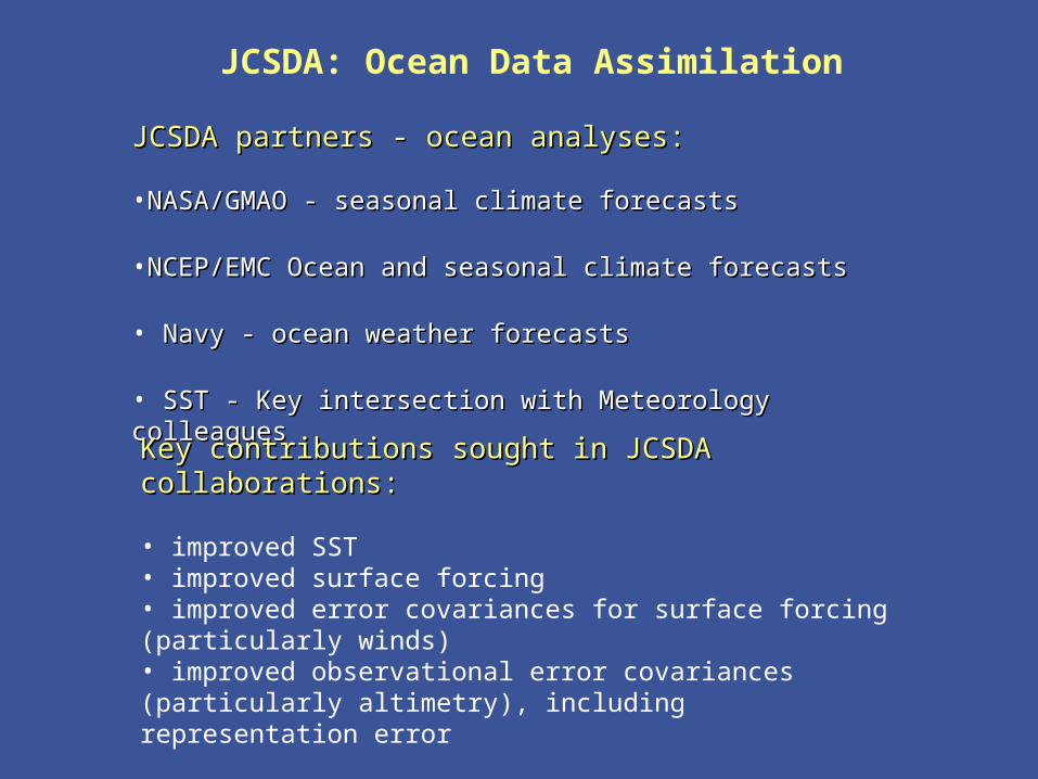
The Global Ocean Data Assimilation System (GODAS) at NCEP
bull The primary purpose of the GODAS is to provide a global ocean analysis to initialize the NCEP Coupled Forecast System (CFS) for seasonal to interannual prediction
bull The GODAS is built on the GFDL Modular Ocean Model (MOMv3) and a 3D variational assimilation scheme
bull The GODAS has been operational since 2003 and the CFS since 2004
bull The following slide puts the GODAS in context
Seasonal to Interannual Forecasting at NCEP
Global OceanData AssimilationSystem (GODAS)
Coupled OceanAtmosphere Forecast
System (CFS03)
SST XBT TAO
Altimeter Argo
Scatterometer
Stress
E-P
Heat Fluxes
SST Anomaly Surface Temperatureamp Rainfall Anomalies
Official SST ForecastOfficial ProbabilisticSurface Temperatureamp Rainfall Forecasts
Seasonal Forecastsfor North America
with ClimateAtmosphere GCM
CCA CAMarkov
CCA OCNMR ENSO
Forecasters
Ocean Initial Conditions
IRI
IRI
The Global Ocean Data Assimilation System (GODAS) at NCEP
bull The operational version of GODAS assimilates temperature profiles and synthetic salinity profiles based on the temperature profile and a local climatological TS-relationship
bull Over most the past 25 years the number of available profiles has varied between 5000 and 6000 per month but within the last year the number has increased to more than 7000 per month as the Argo network fills in
bull The following slide illustrates the changing distribution of temperature profiles The most significant events in this regard have been the advent of the equatorial Pacific TAO moorings in the early 1990s and the growth of the Argo float network in the last few years
+ XBT + TAO + Argo
NCEPHYCOM dynamical model(Ocean Forecasting)
bull1048698 Sub-grid scale parameterizations
bullVertical and horizontal eddy viscosity and mixing Diapycnal mixing
bull1048698 Tide and sea surface pressure
bull1048698 River outflow and run-off
bull1048698 Primitive equation with free surface
bull1048698 Ice dynamics and thermodynamics
Central Setup Specifications
bullDynamical Model HYCOM 2013+ GISSbull[FCT-2] In-house adaptations for tidebullriver outflow ice model
bullInitialization Cold Start coastaldeepbullclimatologies followed by assimilationbullof historical data
bullSurface forcing GFS (NCEP) amp MODISbull(water type)
Central Setup 3
bullAssimilation Scheme Multi-variate 2D OIbullamp 2DVar with vertical extension
bullData Types SST SSH in-situ TS icebullConcentration
bullExtensions Prepare (T(z)S(z)) profilesbullfrom T(z) and SSHA
bullCovariance error Decomposed 3D tobull2DX1D
North Atlantic experiments andsetups in NCEP orthogonal
bull sigma2 25 levels
bull112 deg Initialization and assimilationbullResponse to a hurricane
bull13 deg Calibration of atmospheric forcing
bullSeasonal mixed layer variability
bullCalibration of tides
bull112 deg end-to-end operational system in trial
JCSDA Ocean Data Assimilation
bull Improved SST analysis (Xu Li and John Derber NCEPEMC)
bull Detection and correction of aerosol contamination in infrared SST retrievals (Jim Cummings NRLMonterey Andrew Harris NESDIS)
bull Ocean emissivityreflectance model (N Nalli NESDIS JCSDI)
bull Improving analysis of tropical upper ocean conditions for forecasting (Jim Carton)
bull Errors in sea level height analyses (Alexey Kaplan LDEO)
Improved NCEP SST AnalysisXu Li John Derber
EMCNCEP
Project Objective
To Improve SST Analysis
Use satellite data more effectively
Resolve diurnal variation
Improve first guess
Improved NCEP SST AnalysisXu Li John Derber
EMCNCEP Progress
SST physical retrieval code has been merged into GSI and provided to NCEP marine branch for test in operational mode
An extensive diagnostic study on the diurnal variation signals in in situ and satellite observations SST retrievals SST analysis and associated air-sea fluxes (NCEP GFS product) shows the SST diurnal variation needs to be addressed to improve the SST analysis product
7-day 6-hourly SST analysis has been produced with GSI after a new analysis variable in situ and AVHRR data were introduced into GSI
Plan Analyze SST by assimilating satellite radiances directly
with GSI Active ocean in the GFS Aerosol effects
NCEP Operational RTG Daily Analysis GSI Analysis (Daily Mean of 4 6-h analysis)
GSI (00Z ndash Daily Mean) GSI (12Z ndash Daily Mean)
SST Analysis with GSI Diurnal Variation signal and comparison with RTG Analysis04072005 (7th day of GSI SST analysis)
NCEP Operational RTG Daily Analysis GSI Analysis (Daily Mean of 4 6-h analysis)
GSI (00Z ndash Daily Mean) GSI (12Z ndash Daily Mean)
SST Analysis with GSI Diurnal Variation signal and comparison with RTG Analysis04072005 (7th day of GSI SST analysis)
Detection and correction of aerosol contamination in infrared seas surface temperature retrievals
Contributors NRL Jim Cummings (PI) Doug Westphal (PI) Jeff Hawkins NAVO Doug May UMD Andy Harris
bull Detection of aerosol contamination in infrared satellite sea surface temperature (SST) retrievals using Navy Aerosol Analysis Prediction System (NAAPS) aerosol distributions
bull Correction of satellite SSTs for aerosol contamination using NAAPS aerosol products
Project Objectives
Project TasksProject Tasks
bull Collocate NAAPS optical depth forecast fields valid for the time SST retrievals are generated (Doug May NAVOCEANO)
bull Estimate SST retrieval reliability relationship to AOD content (Doug May NAVOCEANO - Jim Cummings NRL)
bull Develop SST quality control schemes to recognize aerosol contamination (Jim Cummings NRL)
bull Correct satellite SSTs for aerosol contamination (Andy Harris NESDIS)
bull Validate NAAPS aerosol products using using independent data - improve NAAPS model (Jeff Hawkins Doug Westphal NRL)
JCSDA Workshop onSatellite Data Assimilation
Detection and correction of aerosol contamination in infrared seas surface temperature retrievals
Summary of Accomplishments
bull Collocation of NAVO AVHRR SSTs and NAAPS aerosol AODs for each aerosol type 4 times daily
bull Development of discriminant QC function to identify possible aerosol contamination
bull Validation of NAAPS AODs for select Saharan dust events using MODIS AOD retrievals
bull Development of reduced predictor scheme which improves correction of satellite BTs by at least a factor 3 over AOD alone
Contributors NRL Jim Cummings (PI) Doug Westphal (PI) Jeff Hawkins NAVO Doug May UMD Andy Harris
Future - Test correction scheme against aerosol-independent (eg MW) SST Use independent data to improve NAAPS product
NAAPS
01 04 16 64
MODIS
Point-for-point comparison in case study shows bi-modal distribution of bias
Addition of total clear-sky transmittance and air-sea T predictors improves BT correction
37 microm 11 microm 12 microm
Suggested form of k-estimation
ASAS
ASAS
ASAS
TTcTTccc
TTbTTbbb
TTaTTaaa
12321210
11321110
73327310
k
k-coefficients will be different for different aerosol types
Ocean Surface Reflection Ocean Surface Reflection Emissivity ModelEmissivity Model
Nicholas R NalliNicholas R Nalli
andand
Chris Barnet Walter Wolf Mitch Goldberg (Co-Is)Chris Barnet Walter Wolf Mitch Goldberg (Co-Is)
NOAANESDISORANOAANESDISORA
Paul van Delst John Derber (EMC POC)Paul van Delst John Derber (EMC POC)
NOAANCEPEMCNOAANCEPEMC
JSDIJSDI - FY05FY05
Enhancement of Ocean ReflectionEmissivity Enhancement of Ocean ReflectionEmissivity ModelModel
ContributorsContributors
ORA Nicholas Nalli (PI) C Barnet W Wolf M ORA Nicholas Nalli (PI) C Barnet W Wolf M GoldbergGoldberg
EMC P van Delst J DerberEMC P van Delst J Derber
Summary of AccomplishmentsSummary of Accomplishmentsbull Theoretical development of quasi-specular Theoretical development of quasi-specular
reflection model in earlier work (Nalli et al reflection model in earlier work (Nalli et al 2001)2001)
bull Sample M-AERI spectra collected from Sample M-AERI spectra collected from AEROSE 2004 to be published in AEROSE 2004 to be published in JGRJGR Special Issue on AIRS validation (Nalli et Special Issue on AIRS validation (Nalli et al 2005) ndash these data will be used to al 2005) ndash these data will be used to verify and validate modelsverify and validate models
bull UMBC Kcarta installed and compiled on UMBC Kcarta installed and compiled on Linux workstationLinux workstation
M-AERI Brightness Temperatures AEROSE 06-M-AERI Brightness Temperatures AEROSE 06-Mar-04Mar-04
From Nalli et al (2005)
FutureFuturebull Conduct statistical analyses of M-AERI field data to verifyquantify model errorConduct statistical analyses of M-AERI field data to verifyquantify model errorbull Characterize window channel spectral response functions and centroid Planck approximationsCharacterize window channel spectral response functions and centroid Planck approximationsbull Run forward radiance calculations for window channels over range of wind speeds zenith angles and atmospheric conditionsRun forward radiance calculations for window channels over range of wind speeds zenith angles and atmospheric conditionsbull Derive lookup tables andor parametric fit of reflection diffusivity angle designed to be used in conjunction with the Wu-Smith Derive lookup tables andor parametric fit of reflection diffusivity angle designed to be used in conjunction with the Wu-Smith
emissivity model currently implemented by NCEPEMCemissivity model currently implemented by NCEPEMCbull Validate model calculations against M-AERI spectra acquired during oceanographic field campaigns including AEROSE 2004Validate model calculations against M-AERI spectra acquired during oceanographic field campaigns including AEROSE 2004bull Tech transfer to NCEPEMC for operational implementation into CRTMTech transfer to NCEPEMC for operational implementation into CRTMbull Implementation within AIRS forward modelImplementation within AIRS forward model
Ocean Surface IR Emissivity Ocean Surface IR Emissivity and Reflectanceand Reflectancebull Radiance emissivity models (eg Masuda et al 1988 Radiance emissivity models (eg Masuda et al 1988
Watts et al 1996 Wu and Smith 1997) have been derived Watts et al 1996 Wu and Smith 1997) have been derived from Cox-Munk wave slope statisticsfrom Cox-Munk wave slope statistics
bull Lookup tables (LUT) of model emissivity are used in Lookup tables (LUT) of model emissivity are used in radiative transfer modeling radiative transfer modeling
bull Reflectance of atmospheric radiance is a more challenging Reflectance of atmospheric radiance is a more challenging problemproblemndash Surface is neither specular nor Lambertian but Surface is neither specular nor Lambertian but quasi-quasi-
specularspecularndash Depends upon the hemispherical radiance distributionDepends upon the hemispherical radiance distributionndash Using 1 Using 1 may lead to systematic errors of forward radiance may lead to systematic errors of forward radiance
in window channelsin window channelsndash These errors may be significant for applications requiring high These errors may be significant for applications requiring high
accuracy (eg SST)accuracy (eg SST)
)(1 0 Vf
Improved Analysis of Tropical Upper Ocean Conditions for Seasonal to Interannual Forecasting
Contributors UMD Jim Carton (PI) Gennady Chepurin EMC David Behringer
Collaborators Hailong Liu Ching-Yee Chang Sumant Nigam
Project Objectives
Identify the forecast bias in the current NCEP ocean assimilation system (GODAS) and explore methods to control its impact on forecasts
Observations have spatially correlated errors while ocean models have slowly varying biases Most current data assimilation schemes assume zero bias
Improved Analysis of Tropical Upper Ocean Conditions for Seasonal to Interannual Forecasting
faTfa
aTa
1f
1
a
P
ˆHQˆH
2
1)(J
Summary of Accomplishments
bull Identification of time mean and seasonal bias in ocean data assimilation
bull Development and coding of reduced space two-stage bias correction algorithm
bull Examination of systematic errors in seasonal cycle of CFS
Contributors UMD Jim Carton (PI) Gennady Chepurin EMC David Behringer
Collaborators Hailong Liu Ching-Yee Chang Sumant Nigam
Future - implementation and extension to multivariate Exploration of seasonal bias in CFS
Reduced-space bias correction
Where the bias is projected on our model EOFs G
Bias stationarity seasonality suggests a simple forecast bias model
95m temp b ias
Bias in temperature annual cycle
95m Temperature bias EOF decomposition
Sea level height errors in models and dataMonte Carlo simulations and spectral distributions
Contributors LDEO AKaplan (PI) MCane (co-PI) TMerlis
Collaborators GMAO ABorovikov MRienecker CKeppenne
Project goal to provide realistic initializations for ocean components of seasonal-to-interannual climate forecast systems by assimilating satellite observations
To achieve this goal we have to investigate the errors of observational and model data sets and the ways to model them statistically
Dynamical simulations of the ocean model error are still quite rare (CaneMillerKaplan et al Fukumori et al Borovikov et al 2005)
Sea level height errors in models and dataMonte Carlo simulations and spectral distributions
Summary of Accomplishmentsbull The AMIP-based ocean ensemble from GMAO
(Borovikov et al 2005) was analyzed and evaluated vs ensembles driven by small-scale noise
bull Ratios of temporal and spatial contributions to the small-scale sea surface height variability were analyzed and used for modeling observational error in monthly tide gauge sea level values wavenumber spectra are used for satellite altimetry error estimates with regards to the model grid size
Contributors LDEO AKaplan (PI) MCane (co-PI) TMerlis
Collaborators GMAO ABorovikov MRienecker CKeppenne
Future Finalizing error estimates ensembles of ocean simulations perturbed by small-scale variability data assimilation implementations
Latitudinal dependence of time evolution of normalized spread in sea surface height for the GMAO ensemble
Theoretical estimatesfor tide gauge error show goodconsistency with the actual errors for all tropical Pacific tide gauge stations but four (known to manifest local effects or phase shifts of Rossby waves)
Summary
From the workshopbull A lot of good progress
bull Collaborations on SST use of aerosol data - collaboration with Clark Weaver (and A da Silva) on aerosol productsinclude emissivityreflectance model in forward model in NCEP radiance assimilation include ocean mixed layer model (Li Harris Rienecker)
bull Collaborations on Assimilation methodology bias estimation (Carton Keppenne) methods to assimilate altimetry - noise models (Kaplan GMAO) ensemble generation (Kaplan GMAO)
Summary
bull Oceanic satellite data assimilation is one of JCSDArsquos mandates
bullSeveral Directed RampD and AO projects supported
bullInfrastructure issues to be addressed
bullKey advances already made
bullCoastalCoral Reef area a clear area for development
Prologue
bull JCSDA is well positioned to exploit the observational data base to be provided by the GOSGEOSS in terms of
bull Assimilation sciencebull Modeling sciencebull Computing power
Generally the next decade of the environmental satellite program promises to be every bit as exciting as the first given the opportunities provided by new observations modern data assimilation techniques improving environmental modeling capacity and burgeoning computer power
The Joint Center will play a key role in enabling the use of advanced satellite data from both current and future advanced systems for environmental modeling
USA Inc and the Global Community will be significant beneficiaries from the Centers activity
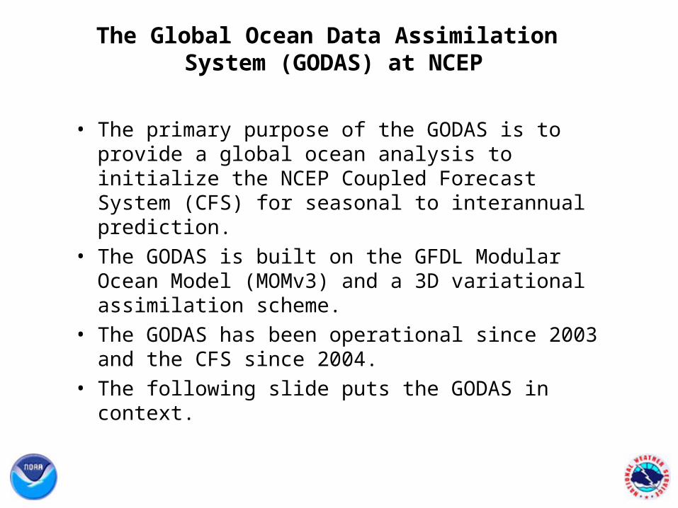
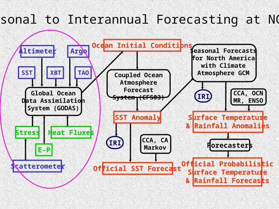
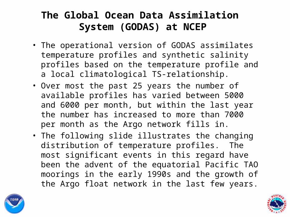
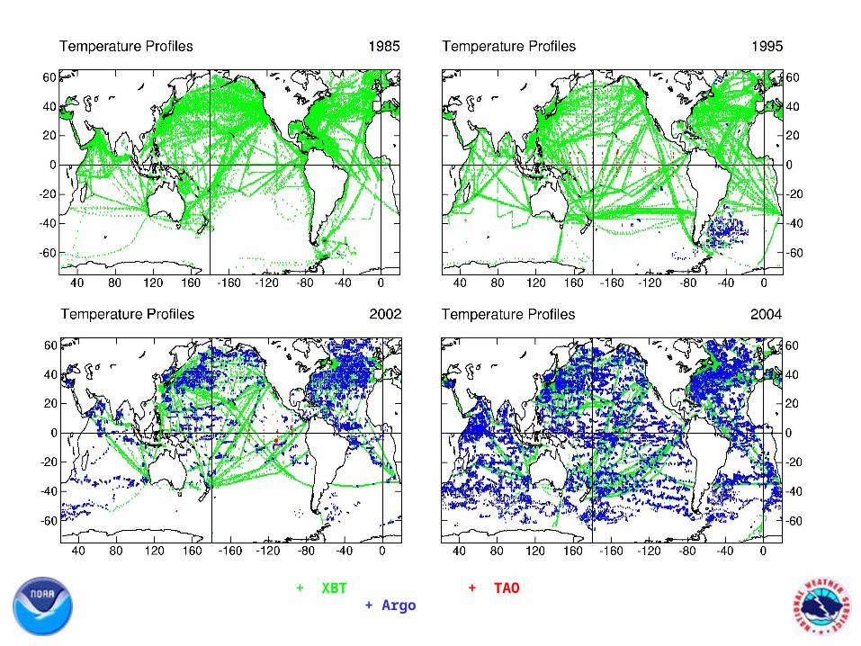
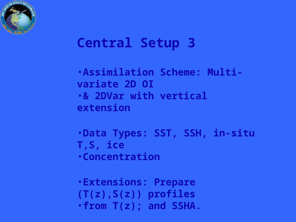
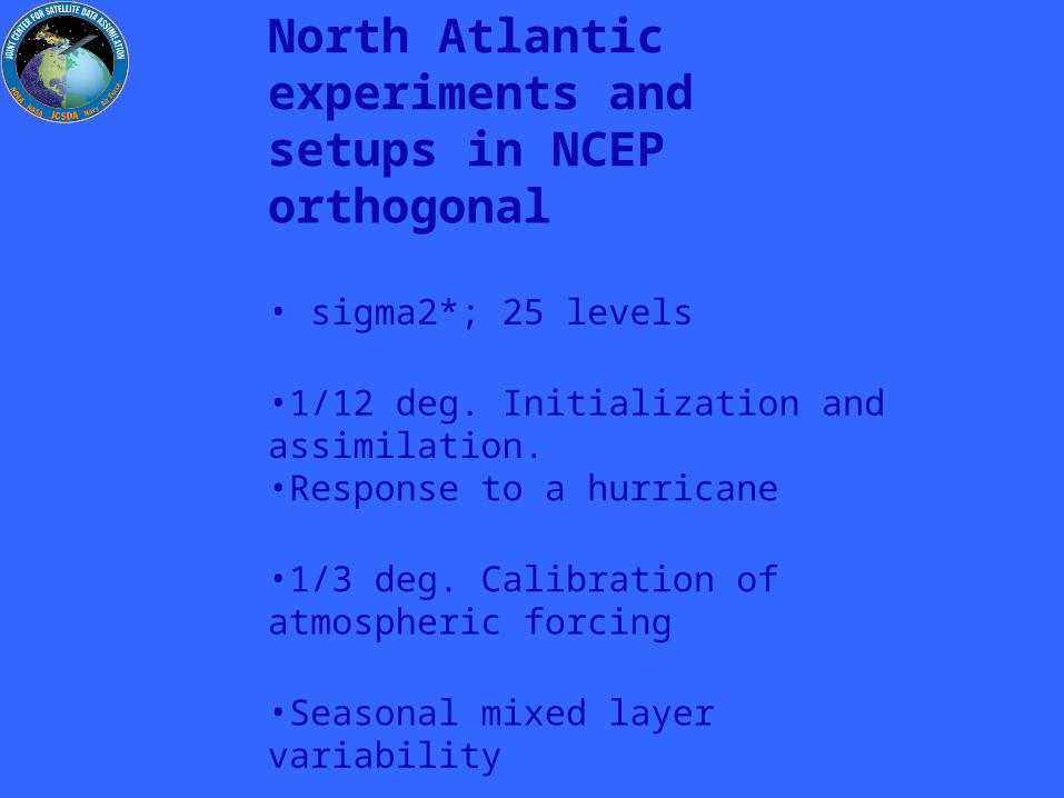
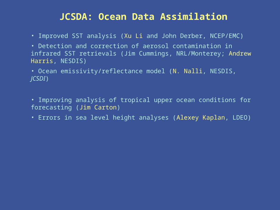
Improved NCEP SST AnalysisXu Li John Derber
EMCNCEP
Project Objective
To Improve SST Analysis
Use satellite data more effectively
Resolve diurnal variation
Improve first guess
Improved NCEP SST AnalysisXu Li John Derber
EMCNCEP Progress
SST physical retrieval code has been merged into GSI and provided to NCEP marine branch for test in operational mode
An extensive diagnostic study on the diurnal variation signals in in situ and satellite observations SST retrievals SST analysis and associated air-sea fluxes (NCEP GFS product) shows the SST diurnal variation needs to be addressed to improve the SST analysis product
7-day 6-hourly SST analysis has been produced with GSI after a new analysis variable in situ and AVHRR data were introduced into GSI
Plan Analyze SST by assimilating satellite radiances directly
with GSI Active ocean in the GFS Aerosol effects
NCEP Operational RTG Daily Analysis GSI Analysis (Daily Mean of 4 6-h analysis)
GSI (00Z ndash Daily Mean) GSI (12Z ndash Daily Mean)
SST Analysis with GSI Diurnal Variation signal and comparison with RTG Analysis04072005 (7th day of GSI SST analysis)
NCEP Operational RTG Daily Analysis GSI Analysis (Daily Mean of 4 6-h analysis)
GSI (00Z ndash Daily Mean) GSI (12Z ndash Daily Mean)
SST Analysis with GSI Diurnal Variation signal and comparison with RTG Analysis04072005 (7th day of GSI SST analysis)
Detection and correction of aerosol contamination in infrared seas surface temperature retrievals
Contributors NRL Jim Cummings (PI) Doug Westphal (PI) Jeff Hawkins NAVO Doug May UMD Andy Harris
bull Detection of aerosol contamination in infrared satellite sea surface temperature (SST) retrievals using Navy Aerosol Analysis Prediction System (NAAPS) aerosol distributions
bull Correction of satellite SSTs for aerosol contamination using NAAPS aerosol products
Project Objectives
Project TasksProject Tasks
bull Collocate NAAPS optical depth forecast fields valid for the time SST retrievals are generated (Doug May NAVOCEANO)
bull Estimate SST retrieval reliability relationship to AOD content (Doug May NAVOCEANO - Jim Cummings NRL)
bull Develop SST quality control schemes to recognize aerosol contamination (Jim Cummings NRL)
bull Correct satellite SSTs for aerosol contamination (Andy Harris NESDIS)
bull Validate NAAPS aerosol products using using independent data - improve NAAPS model (Jeff Hawkins Doug Westphal NRL)
JCSDA Workshop onSatellite Data Assimilation
Detection and correction of aerosol contamination in infrared seas surface temperature retrievals
Summary of Accomplishments
bull Collocation of NAVO AVHRR SSTs and NAAPS aerosol AODs for each aerosol type 4 times daily
bull Development of discriminant QC function to identify possible aerosol contamination
bull Validation of NAAPS AODs for select Saharan dust events using MODIS AOD retrievals
bull Development of reduced predictor scheme which improves correction of satellite BTs by at least a factor 3 over AOD alone
Contributors NRL Jim Cummings (PI) Doug Westphal (PI) Jeff Hawkins NAVO Doug May UMD Andy Harris
Future - Test correction scheme against aerosol-independent (eg MW) SST Use independent data to improve NAAPS product
NAAPS
01 04 16 64
MODIS
Point-for-point comparison in case study shows bi-modal distribution of bias
Addition of total clear-sky transmittance and air-sea T predictors improves BT correction
37 microm 11 microm 12 microm
Suggested form of k-estimation
ASAS
ASAS
ASAS
TTcTTccc
TTbTTbbb
TTaTTaaa
12321210
11321110
73327310
k
k-coefficients will be different for different aerosol types
Ocean Surface Reflection Ocean Surface Reflection Emissivity ModelEmissivity Model
Nicholas R NalliNicholas R Nalli
andand
Chris Barnet Walter Wolf Mitch Goldberg (Co-Is)Chris Barnet Walter Wolf Mitch Goldberg (Co-Is)
NOAANESDISORANOAANESDISORA
Paul van Delst John Derber (EMC POC)Paul van Delst John Derber (EMC POC)
NOAANCEPEMCNOAANCEPEMC
JSDIJSDI - FY05FY05
Enhancement of Ocean ReflectionEmissivity Enhancement of Ocean ReflectionEmissivity ModelModel
ContributorsContributors
ORA Nicholas Nalli (PI) C Barnet W Wolf M ORA Nicholas Nalli (PI) C Barnet W Wolf M GoldbergGoldberg
EMC P van Delst J DerberEMC P van Delst J Derber
Summary of AccomplishmentsSummary of Accomplishmentsbull Theoretical development of quasi-specular Theoretical development of quasi-specular
reflection model in earlier work (Nalli et al reflection model in earlier work (Nalli et al 2001)2001)
bull Sample M-AERI spectra collected from Sample M-AERI spectra collected from AEROSE 2004 to be published in AEROSE 2004 to be published in JGRJGR Special Issue on AIRS validation (Nalli et Special Issue on AIRS validation (Nalli et al 2005) ndash these data will be used to al 2005) ndash these data will be used to verify and validate modelsverify and validate models
bull UMBC Kcarta installed and compiled on UMBC Kcarta installed and compiled on Linux workstationLinux workstation
M-AERI Brightness Temperatures AEROSE 06-M-AERI Brightness Temperatures AEROSE 06-Mar-04Mar-04
From Nalli et al (2005)
FutureFuturebull Conduct statistical analyses of M-AERI field data to verifyquantify model errorConduct statistical analyses of M-AERI field data to verifyquantify model errorbull Characterize window channel spectral response functions and centroid Planck approximationsCharacterize window channel spectral response functions and centroid Planck approximationsbull Run forward radiance calculations for window channels over range of wind speeds zenith angles and atmospheric conditionsRun forward radiance calculations for window channels over range of wind speeds zenith angles and atmospheric conditionsbull Derive lookup tables andor parametric fit of reflection diffusivity angle designed to be used in conjunction with the Wu-Smith Derive lookup tables andor parametric fit of reflection diffusivity angle designed to be used in conjunction with the Wu-Smith
emissivity model currently implemented by NCEPEMCemissivity model currently implemented by NCEPEMCbull Validate model calculations against M-AERI spectra acquired during oceanographic field campaigns including AEROSE 2004Validate model calculations against M-AERI spectra acquired during oceanographic field campaigns including AEROSE 2004bull Tech transfer to NCEPEMC for operational implementation into CRTMTech transfer to NCEPEMC for operational implementation into CRTMbull Implementation within AIRS forward modelImplementation within AIRS forward model
Ocean Surface IR Emissivity Ocean Surface IR Emissivity and Reflectanceand Reflectancebull Radiance emissivity models (eg Masuda et al 1988 Radiance emissivity models (eg Masuda et al 1988
Watts et al 1996 Wu and Smith 1997) have been derived Watts et al 1996 Wu and Smith 1997) have been derived from Cox-Munk wave slope statisticsfrom Cox-Munk wave slope statistics
bull Lookup tables (LUT) of model emissivity are used in Lookup tables (LUT) of model emissivity are used in radiative transfer modeling radiative transfer modeling
bull Reflectance of atmospheric radiance is a more challenging Reflectance of atmospheric radiance is a more challenging problemproblemndash Surface is neither specular nor Lambertian but Surface is neither specular nor Lambertian but quasi-quasi-
specularspecularndash Depends upon the hemispherical radiance distributionDepends upon the hemispherical radiance distributionndash Using 1 Using 1 may lead to systematic errors of forward radiance may lead to systematic errors of forward radiance
in window channelsin window channelsndash These errors may be significant for applications requiring high These errors may be significant for applications requiring high
accuracy (eg SST)accuracy (eg SST)
)(1 0 Vf
Improved Analysis of Tropical Upper Ocean Conditions for Seasonal to Interannual Forecasting
Contributors UMD Jim Carton (PI) Gennady Chepurin EMC David Behringer
Collaborators Hailong Liu Ching-Yee Chang Sumant Nigam
Project Objectives
Identify the forecast bias in the current NCEP ocean assimilation system (GODAS) and explore methods to control its impact on forecasts
Observations have spatially correlated errors while ocean models have slowly varying biases Most current data assimilation schemes assume zero bias
Improved Analysis of Tropical Upper Ocean Conditions for Seasonal to Interannual Forecasting
faTfa
aTa
1f
1
a
P
ˆHQˆH
2
1)(J
Summary of Accomplishments
bull Identification of time mean and seasonal bias in ocean data assimilation
bull Development and coding of reduced space two-stage bias correction algorithm
bull Examination of systematic errors in seasonal cycle of CFS
Contributors UMD Jim Carton (PI) Gennady Chepurin EMC David Behringer
Collaborators Hailong Liu Ching-Yee Chang Sumant Nigam
Future - implementation and extension to multivariate Exploration of seasonal bias in CFS
Reduced-space bias correction
Where the bias is projected on our model EOFs G
Bias stationarity seasonality suggests a simple forecast bias model
95m temp b ias
Bias in temperature annual cycle
95m Temperature bias EOF decomposition
Sea level height errors in models and dataMonte Carlo simulations and spectral distributions
Contributors LDEO AKaplan (PI) MCane (co-PI) TMerlis
Collaborators GMAO ABorovikov MRienecker CKeppenne
Project goal to provide realistic initializations for ocean components of seasonal-to-interannual climate forecast systems by assimilating satellite observations
To achieve this goal we have to investigate the errors of observational and model data sets and the ways to model them statistically
Dynamical simulations of the ocean model error are still quite rare (CaneMillerKaplan et al Fukumori et al Borovikov et al 2005)
Sea level height errors in models and dataMonte Carlo simulations and spectral distributions
Summary of Accomplishmentsbull The AMIP-based ocean ensemble from GMAO
(Borovikov et al 2005) was analyzed and evaluated vs ensembles driven by small-scale noise
bull Ratios of temporal and spatial contributions to the small-scale sea surface height variability were analyzed and used for modeling observational error in monthly tide gauge sea level values wavenumber spectra are used for satellite altimetry error estimates with regards to the model grid size
Contributors LDEO AKaplan (PI) MCane (co-PI) TMerlis
Collaborators GMAO ABorovikov MRienecker CKeppenne
Future Finalizing error estimates ensembles of ocean simulations perturbed by small-scale variability data assimilation implementations
Latitudinal dependence of time evolution of normalized spread in sea surface height for the GMAO ensemble
Theoretical estimatesfor tide gauge error show goodconsistency with the actual errors for all tropical Pacific tide gauge stations but four (known to manifest local effects or phase shifts of Rossby waves)
Summary
From the workshopbull A lot of good progress
bull Collaborations on SST use of aerosol data - collaboration with Clark Weaver (and A da Silva) on aerosol productsinclude emissivityreflectance model in forward model in NCEP radiance assimilation include ocean mixed layer model (Li Harris Rienecker)
bull Collaborations on Assimilation methodology bias estimation (Carton Keppenne) methods to assimilate altimetry - noise models (Kaplan GMAO) ensemble generation (Kaplan GMAO)
Summary
bull Oceanic satellite data assimilation is one of JCSDArsquos mandates
bullSeveral Directed RampD and AO projects supported
bullInfrastructure issues to be addressed
bullKey advances already made
bullCoastalCoral Reef area a clear area for development
Prologue
bull JCSDA is well positioned to exploit the observational data base to be provided by the GOSGEOSS in terms of
bull Assimilation sciencebull Modeling sciencebull Computing power
Generally the next decade of the environmental satellite program promises to be every bit as exciting as the first given the opportunities provided by new observations modern data assimilation techniques improving environmental modeling capacity and burgeoning computer power
The Joint Center will play a key role in enabling the use of advanced satellite data from both current and future advanced systems for environmental modeling
USA Inc and the Global Community will be significant beneficiaries from the Centers activity
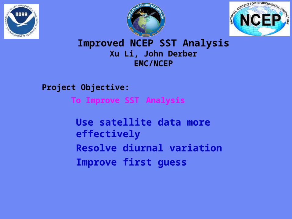
Improved NCEP SST AnalysisXu Li John Derber
EMCNCEP Progress
SST physical retrieval code has been merged into GSI and provided to NCEP marine branch for test in operational mode
An extensive diagnostic study on the diurnal variation signals in in situ and satellite observations SST retrievals SST analysis and associated air-sea fluxes (NCEP GFS product) shows the SST diurnal variation needs to be addressed to improve the SST analysis product
7-day 6-hourly SST analysis has been produced with GSI after a new analysis variable in situ and AVHRR data were introduced into GSI
Plan Analyze SST by assimilating satellite radiances directly
with GSI Active ocean in the GFS Aerosol effects
NCEP Operational RTG Daily Analysis GSI Analysis (Daily Mean of 4 6-h analysis)
GSI (00Z ndash Daily Mean) GSI (12Z ndash Daily Mean)
SST Analysis with GSI Diurnal Variation signal and comparison with RTG Analysis04072005 (7th day of GSI SST analysis)
NCEP Operational RTG Daily Analysis GSI Analysis (Daily Mean of 4 6-h analysis)
GSI (00Z ndash Daily Mean) GSI (12Z ndash Daily Mean)
SST Analysis with GSI Diurnal Variation signal and comparison with RTG Analysis04072005 (7th day of GSI SST analysis)
Detection and correction of aerosol contamination in infrared seas surface temperature retrievals
Contributors NRL Jim Cummings (PI) Doug Westphal (PI) Jeff Hawkins NAVO Doug May UMD Andy Harris
bull Detection of aerosol contamination in infrared satellite sea surface temperature (SST) retrievals using Navy Aerosol Analysis Prediction System (NAAPS) aerosol distributions
bull Correction of satellite SSTs for aerosol contamination using NAAPS aerosol products
Project Objectives
Project TasksProject Tasks
bull Collocate NAAPS optical depth forecast fields valid for the time SST retrievals are generated (Doug May NAVOCEANO)
bull Estimate SST retrieval reliability relationship to AOD content (Doug May NAVOCEANO - Jim Cummings NRL)
bull Develop SST quality control schemes to recognize aerosol contamination (Jim Cummings NRL)
bull Correct satellite SSTs for aerosol contamination (Andy Harris NESDIS)
bull Validate NAAPS aerosol products using using independent data - improve NAAPS model (Jeff Hawkins Doug Westphal NRL)
JCSDA Workshop onSatellite Data Assimilation
Detection and correction of aerosol contamination in infrared seas surface temperature retrievals
Summary of Accomplishments
bull Collocation of NAVO AVHRR SSTs and NAAPS aerosol AODs for each aerosol type 4 times daily
bull Development of discriminant QC function to identify possible aerosol contamination
bull Validation of NAAPS AODs for select Saharan dust events using MODIS AOD retrievals
bull Development of reduced predictor scheme which improves correction of satellite BTs by at least a factor 3 over AOD alone
Contributors NRL Jim Cummings (PI) Doug Westphal (PI) Jeff Hawkins NAVO Doug May UMD Andy Harris
Future - Test correction scheme against aerosol-independent (eg MW) SST Use independent data to improve NAAPS product
NAAPS
01 04 16 64
MODIS
Point-for-point comparison in case study shows bi-modal distribution of bias
Addition of total clear-sky transmittance and air-sea T predictors improves BT correction
37 microm 11 microm 12 microm
Suggested form of k-estimation
ASAS
ASAS
ASAS
TTcTTccc
TTbTTbbb
TTaTTaaa
12321210
11321110
73327310
k
k-coefficients will be different for different aerosol types
Ocean Surface Reflection Ocean Surface Reflection Emissivity ModelEmissivity Model
Nicholas R NalliNicholas R Nalli
andand
Chris Barnet Walter Wolf Mitch Goldberg (Co-Is)Chris Barnet Walter Wolf Mitch Goldberg (Co-Is)
NOAANESDISORANOAANESDISORA
Paul van Delst John Derber (EMC POC)Paul van Delst John Derber (EMC POC)
NOAANCEPEMCNOAANCEPEMC
JSDIJSDI - FY05FY05
Enhancement of Ocean ReflectionEmissivity Enhancement of Ocean ReflectionEmissivity ModelModel
ContributorsContributors
ORA Nicholas Nalli (PI) C Barnet W Wolf M ORA Nicholas Nalli (PI) C Barnet W Wolf M GoldbergGoldberg
EMC P van Delst J DerberEMC P van Delst J Derber
Summary of AccomplishmentsSummary of Accomplishmentsbull Theoretical development of quasi-specular Theoretical development of quasi-specular
reflection model in earlier work (Nalli et al reflection model in earlier work (Nalli et al 2001)2001)
bull Sample M-AERI spectra collected from Sample M-AERI spectra collected from AEROSE 2004 to be published in AEROSE 2004 to be published in JGRJGR Special Issue on AIRS validation (Nalli et Special Issue on AIRS validation (Nalli et al 2005) ndash these data will be used to al 2005) ndash these data will be used to verify and validate modelsverify and validate models
bull UMBC Kcarta installed and compiled on UMBC Kcarta installed and compiled on Linux workstationLinux workstation
M-AERI Brightness Temperatures AEROSE 06-M-AERI Brightness Temperatures AEROSE 06-Mar-04Mar-04
From Nalli et al (2005)
FutureFuturebull Conduct statistical analyses of M-AERI field data to verifyquantify model errorConduct statistical analyses of M-AERI field data to verifyquantify model errorbull Characterize window channel spectral response functions and centroid Planck approximationsCharacterize window channel spectral response functions and centroid Planck approximationsbull Run forward radiance calculations for window channels over range of wind speeds zenith angles and atmospheric conditionsRun forward radiance calculations for window channels over range of wind speeds zenith angles and atmospheric conditionsbull Derive lookup tables andor parametric fit of reflection diffusivity angle designed to be used in conjunction with the Wu-Smith Derive lookup tables andor parametric fit of reflection diffusivity angle designed to be used in conjunction with the Wu-Smith
emissivity model currently implemented by NCEPEMCemissivity model currently implemented by NCEPEMCbull Validate model calculations against M-AERI spectra acquired during oceanographic field campaigns including AEROSE 2004Validate model calculations against M-AERI spectra acquired during oceanographic field campaigns including AEROSE 2004bull Tech transfer to NCEPEMC for operational implementation into CRTMTech transfer to NCEPEMC for operational implementation into CRTMbull Implementation within AIRS forward modelImplementation within AIRS forward model
Ocean Surface IR Emissivity Ocean Surface IR Emissivity and Reflectanceand Reflectancebull Radiance emissivity models (eg Masuda et al 1988 Radiance emissivity models (eg Masuda et al 1988
Watts et al 1996 Wu and Smith 1997) have been derived Watts et al 1996 Wu and Smith 1997) have been derived from Cox-Munk wave slope statisticsfrom Cox-Munk wave slope statistics
bull Lookup tables (LUT) of model emissivity are used in Lookup tables (LUT) of model emissivity are used in radiative transfer modeling radiative transfer modeling
bull Reflectance of atmospheric radiance is a more challenging Reflectance of atmospheric radiance is a more challenging problemproblemndash Surface is neither specular nor Lambertian but Surface is neither specular nor Lambertian but quasi-quasi-
specularspecularndash Depends upon the hemispherical radiance distributionDepends upon the hemispherical radiance distributionndash Using 1 Using 1 may lead to systematic errors of forward radiance may lead to systematic errors of forward radiance
in window channelsin window channelsndash These errors may be significant for applications requiring high These errors may be significant for applications requiring high
accuracy (eg SST)accuracy (eg SST)
)(1 0 Vf
Improved Analysis of Tropical Upper Ocean Conditions for Seasonal to Interannual Forecasting
Contributors UMD Jim Carton (PI) Gennady Chepurin EMC David Behringer
Collaborators Hailong Liu Ching-Yee Chang Sumant Nigam
Project Objectives
Identify the forecast bias in the current NCEP ocean assimilation system (GODAS) and explore methods to control its impact on forecasts
Observations have spatially correlated errors while ocean models have slowly varying biases Most current data assimilation schemes assume zero bias
Improved Analysis of Tropical Upper Ocean Conditions for Seasonal to Interannual Forecasting
faTfa
aTa
1f
1
a
P
ˆHQˆH
2
1)(J
Summary of Accomplishments
bull Identification of time mean and seasonal bias in ocean data assimilation
bull Development and coding of reduced space two-stage bias correction algorithm
bull Examination of systematic errors in seasonal cycle of CFS
Contributors UMD Jim Carton (PI) Gennady Chepurin EMC David Behringer
Collaborators Hailong Liu Ching-Yee Chang Sumant Nigam
Future - implementation and extension to multivariate Exploration of seasonal bias in CFS
Reduced-space bias correction
Where the bias is projected on our model EOFs G
Bias stationarity seasonality suggests a simple forecast bias model
95m temp b ias
Bias in temperature annual cycle
95m Temperature bias EOF decomposition
Sea level height errors in models and dataMonte Carlo simulations and spectral distributions
Contributors LDEO AKaplan (PI) MCane (co-PI) TMerlis
Collaborators GMAO ABorovikov MRienecker CKeppenne
Project goal to provide realistic initializations for ocean components of seasonal-to-interannual climate forecast systems by assimilating satellite observations
To achieve this goal we have to investigate the errors of observational and model data sets and the ways to model them statistically
Dynamical simulations of the ocean model error are still quite rare (CaneMillerKaplan et al Fukumori et al Borovikov et al 2005)
Sea level height errors in models and dataMonte Carlo simulations and spectral distributions
Summary of Accomplishmentsbull The AMIP-based ocean ensemble from GMAO
(Borovikov et al 2005) was analyzed and evaluated vs ensembles driven by small-scale noise
bull Ratios of temporal and spatial contributions to the small-scale sea surface height variability were analyzed and used for modeling observational error in monthly tide gauge sea level values wavenumber spectra are used for satellite altimetry error estimates with regards to the model grid size
Contributors LDEO AKaplan (PI) MCane (co-PI) TMerlis
Collaborators GMAO ABorovikov MRienecker CKeppenne
Future Finalizing error estimates ensembles of ocean simulations perturbed by small-scale variability data assimilation implementations
Latitudinal dependence of time evolution of normalized spread in sea surface height for the GMAO ensemble
Theoretical estimatesfor tide gauge error show goodconsistency with the actual errors for all tropical Pacific tide gauge stations but four (known to manifest local effects or phase shifts of Rossby waves)
Summary
From the workshopbull A lot of good progress
bull Collaborations on SST use of aerosol data - collaboration with Clark Weaver (and A da Silva) on aerosol productsinclude emissivityreflectance model in forward model in NCEP radiance assimilation include ocean mixed layer model (Li Harris Rienecker)
bull Collaborations on Assimilation methodology bias estimation (Carton Keppenne) methods to assimilate altimetry - noise models (Kaplan GMAO) ensemble generation (Kaplan GMAO)
Summary
bull Oceanic satellite data assimilation is one of JCSDArsquos mandates
bullSeveral Directed RampD and AO projects supported
bullInfrastructure issues to be addressed
bullKey advances already made
bullCoastalCoral Reef area a clear area for development
Prologue
bull JCSDA is well positioned to exploit the observational data base to be provided by the GOSGEOSS in terms of
bull Assimilation sciencebull Modeling sciencebull Computing power
Generally the next decade of the environmental satellite program promises to be every bit as exciting as the first given the opportunities provided by new observations modern data assimilation techniques improving environmental modeling capacity and burgeoning computer power
The Joint Center will play a key role in enabling the use of advanced satellite data from both current and future advanced systems for environmental modeling
USA Inc and the Global Community will be significant beneficiaries from the Centers activity
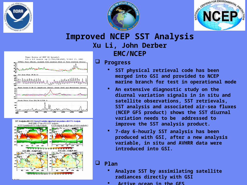
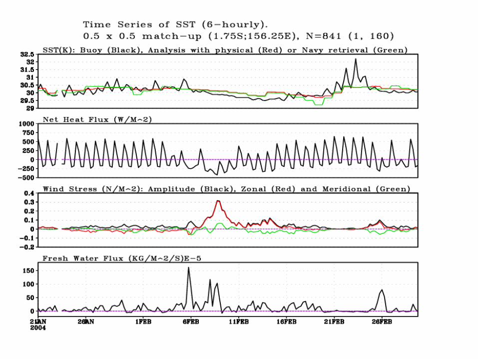
Detection and correction of aerosol contamination in infrared seas surface temperature retrievals
Contributors NRL Jim Cummings (PI) Doug Westphal (PI) Jeff Hawkins NAVO Doug May UMD Andy Harris
bull Detection of aerosol contamination in infrared satellite sea surface temperature (SST) retrievals using Navy Aerosol Analysis Prediction System (NAAPS) aerosol distributions
bull Correction of satellite SSTs for aerosol contamination using NAAPS aerosol products
Project Objectives
Project TasksProject Tasks
bull Collocate NAAPS optical depth forecast fields valid for the time SST retrievals are generated (Doug May NAVOCEANO)
bull Estimate SST retrieval reliability relationship to AOD content (Doug May NAVOCEANO - Jim Cummings NRL)
bull Develop SST quality control schemes to recognize aerosol contamination (Jim Cummings NRL)
bull Correct satellite SSTs for aerosol contamination (Andy Harris NESDIS)
bull Validate NAAPS aerosol products using using independent data - improve NAAPS model (Jeff Hawkins Doug Westphal NRL)
JCSDA Workshop onSatellite Data Assimilation
Detection and correction of aerosol contamination in infrared seas surface temperature retrievals
Summary of Accomplishments
bull Collocation of NAVO AVHRR SSTs and NAAPS aerosol AODs for each aerosol type 4 times daily
bull Development of discriminant QC function to identify possible aerosol contamination
bull Validation of NAAPS AODs for select Saharan dust events using MODIS AOD retrievals
bull Development of reduced predictor scheme which improves correction of satellite BTs by at least a factor 3 over AOD alone
Contributors NRL Jim Cummings (PI) Doug Westphal (PI) Jeff Hawkins NAVO Doug May UMD Andy Harris
Future - Test correction scheme against aerosol-independent (eg MW) SST Use independent data to improve NAAPS product
NAAPS
01 04 16 64
MODIS
Point-for-point comparison in case study shows bi-modal distribution of bias
Addition of total clear-sky transmittance and air-sea T predictors improves BT correction
37 microm 11 microm 12 microm
Suggested form of k-estimation
ASAS
ASAS
ASAS
TTcTTccc
TTbTTbbb
TTaTTaaa
12321210
11321110
73327310
k
k-coefficients will be different for different aerosol types
Ocean Surface Reflection Ocean Surface Reflection Emissivity ModelEmissivity Model
Nicholas R NalliNicholas R Nalli
andand
Chris Barnet Walter Wolf Mitch Goldberg (Co-Is)Chris Barnet Walter Wolf Mitch Goldberg (Co-Is)
NOAANESDISORANOAANESDISORA
Paul van Delst John Derber (EMC POC)Paul van Delst John Derber (EMC POC)
NOAANCEPEMCNOAANCEPEMC
JSDIJSDI - FY05FY05
Enhancement of Ocean ReflectionEmissivity Enhancement of Ocean ReflectionEmissivity ModelModel
ContributorsContributors
ORA Nicholas Nalli (PI) C Barnet W Wolf M ORA Nicholas Nalli (PI) C Barnet W Wolf M GoldbergGoldberg
EMC P van Delst J DerberEMC P van Delst J Derber
Summary of AccomplishmentsSummary of Accomplishmentsbull Theoretical development of quasi-specular Theoretical development of quasi-specular
reflection model in earlier work (Nalli et al reflection model in earlier work (Nalli et al 2001)2001)
bull Sample M-AERI spectra collected from Sample M-AERI spectra collected from AEROSE 2004 to be published in AEROSE 2004 to be published in JGRJGR Special Issue on AIRS validation (Nalli et Special Issue on AIRS validation (Nalli et al 2005) ndash these data will be used to al 2005) ndash these data will be used to verify and validate modelsverify and validate models
bull UMBC Kcarta installed and compiled on UMBC Kcarta installed and compiled on Linux workstationLinux workstation
M-AERI Brightness Temperatures AEROSE 06-M-AERI Brightness Temperatures AEROSE 06-Mar-04Mar-04
From Nalli et al (2005)
FutureFuturebull Conduct statistical analyses of M-AERI field data to verifyquantify model errorConduct statistical analyses of M-AERI field data to verifyquantify model errorbull Characterize window channel spectral response functions and centroid Planck approximationsCharacterize window channel spectral response functions and centroid Planck approximationsbull Run forward radiance calculations for window channels over range of wind speeds zenith angles and atmospheric conditionsRun forward radiance calculations for window channels over range of wind speeds zenith angles and atmospheric conditionsbull Derive lookup tables andor parametric fit of reflection diffusivity angle designed to be used in conjunction with the Wu-Smith Derive lookup tables andor parametric fit of reflection diffusivity angle designed to be used in conjunction with the Wu-Smith
emissivity model currently implemented by NCEPEMCemissivity model currently implemented by NCEPEMCbull Validate model calculations against M-AERI spectra acquired during oceanographic field campaigns including AEROSE 2004Validate model calculations against M-AERI spectra acquired during oceanographic field campaigns including AEROSE 2004bull Tech transfer to NCEPEMC for operational implementation into CRTMTech transfer to NCEPEMC for operational implementation into CRTMbull Implementation within AIRS forward modelImplementation within AIRS forward model
Ocean Surface IR Emissivity Ocean Surface IR Emissivity and Reflectanceand Reflectancebull Radiance emissivity models (eg Masuda et al 1988 Radiance emissivity models (eg Masuda et al 1988
Watts et al 1996 Wu and Smith 1997) have been derived Watts et al 1996 Wu and Smith 1997) have been derived from Cox-Munk wave slope statisticsfrom Cox-Munk wave slope statistics
bull Lookup tables (LUT) of model emissivity are used in Lookup tables (LUT) of model emissivity are used in radiative transfer modeling radiative transfer modeling
bull Reflectance of atmospheric radiance is a more challenging Reflectance of atmospheric radiance is a more challenging problemproblemndash Surface is neither specular nor Lambertian but Surface is neither specular nor Lambertian but quasi-quasi-
specularspecularndash Depends upon the hemispherical radiance distributionDepends upon the hemispherical radiance distributionndash Using 1 Using 1 may lead to systematic errors of forward radiance may lead to systematic errors of forward radiance
in window channelsin window channelsndash These errors may be significant for applications requiring high These errors may be significant for applications requiring high
accuracy (eg SST)accuracy (eg SST)
)(1 0 Vf
Improved Analysis of Tropical Upper Ocean Conditions for Seasonal to Interannual Forecasting
Contributors UMD Jim Carton (PI) Gennady Chepurin EMC David Behringer
Collaborators Hailong Liu Ching-Yee Chang Sumant Nigam
Project Objectives
Identify the forecast bias in the current NCEP ocean assimilation system (GODAS) and explore methods to control its impact on forecasts
Observations have spatially correlated errors while ocean models have slowly varying biases Most current data assimilation schemes assume zero bias
Improved Analysis of Tropical Upper Ocean Conditions for Seasonal to Interannual Forecasting
faTfa
aTa
1f
1
a
P
ˆHQˆH
2
1)(J
Summary of Accomplishments
bull Identification of time mean and seasonal bias in ocean data assimilation
bull Development and coding of reduced space two-stage bias correction algorithm
bull Examination of systematic errors in seasonal cycle of CFS
Contributors UMD Jim Carton (PI) Gennady Chepurin EMC David Behringer
Collaborators Hailong Liu Ching-Yee Chang Sumant Nigam
Future - implementation and extension to multivariate Exploration of seasonal bias in CFS
Reduced-space bias correction
Where the bias is projected on our model EOFs G
Bias stationarity seasonality suggests a simple forecast bias model
95m temp b ias
Bias in temperature annual cycle
95m Temperature bias EOF decomposition
Sea level height errors in models and dataMonte Carlo simulations and spectral distributions
Contributors LDEO AKaplan (PI) MCane (co-PI) TMerlis
Collaborators GMAO ABorovikov MRienecker CKeppenne
Project goal to provide realistic initializations for ocean components of seasonal-to-interannual climate forecast systems by assimilating satellite observations
To achieve this goal we have to investigate the errors of observational and model data sets and the ways to model them statistically
Dynamical simulations of the ocean model error are still quite rare (CaneMillerKaplan et al Fukumori et al Borovikov et al 2005)
Sea level height errors in models and dataMonte Carlo simulations and spectral distributions
Summary of Accomplishmentsbull The AMIP-based ocean ensemble from GMAO
(Borovikov et al 2005) was analyzed and evaluated vs ensembles driven by small-scale noise
bull Ratios of temporal and spatial contributions to the small-scale sea surface height variability were analyzed and used for modeling observational error in monthly tide gauge sea level values wavenumber spectra are used for satellite altimetry error estimates with regards to the model grid size
Contributors LDEO AKaplan (PI) MCane (co-PI) TMerlis
Collaborators GMAO ABorovikov MRienecker CKeppenne
Future Finalizing error estimates ensembles of ocean simulations perturbed by small-scale variability data assimilation implementations
Latitudinal dependence of time evolution of normalized spread in sea surface height for the GMAO ensemble
Theoretical estimatesfor tide gauge error show goodconsistency with the actual errors for all tropical Pacific tide gauge stations but four (known to manifest local effects or phase shifts of Rossby waves)
Summary
From the workshopbull A lot of good progress
bull Collaborations on SST use of aerosol data - collaboration with Clark Weaver (and A da Silva) on aerosol productsinclude emissivityreflectance model in forward model in NCEP radiance assimilation include ocean mixed layer model (Li Harris Rienecker)
bull Collaborations on Assimilation methodology bias estimation (Carton Keppenne) methods to assimilate altimetry - noise models (Kaplan GMAO) ensemble generation (Kaplan GMAO)
Summary
bull Oceanic satellite data assimilation is one of JCSDArsquos mandates
bullSeveral Directed RampD and AO projects supported
bullInfrastructure issues to be addressed
bullKey advances already made
bullCoastalCoral Reef area a clear area for development
Prologue
bull JCSDA is well positioned to exploit the observational data base to be provided by the GOSGEOSS in terms of
bull Assimilation sciencebull Modeling sciencebull Computing power
Generally the next decade of the environmental satellite program promises to be every bit as exciting as the first given the opportunities provided by new observations modern data assimilation techniques improving environmental modeling capacity and burgeoning computer power
The Joint Center will play a key role in enabling the use of advanced satellite data from both current and future advanced systems for environmental modeling
USA Inc and the Global Community will be significant beneficiaries from the Centers activity
Improved Analysis of Tropical Upper Ocean Conditions for Seasonal to Interannual Forecasting
Contributors UMD Jim Carton (PI) Gennady Chepurin EMC David Behringer
Collaborators Hailong Liu Ching-Yee Chang Sumant Nigam
Project Objectives
Identify the forecast bias in the current NCEP ocean assimilation system (GODAS) and explore methods to control its impact on forecasts
Observations have spatially correlated errors while ocean models have slowly varying biases Most current data assimilation schemes assume zero bias
Improved Analysis of Tropical Upper Ocean Conditions for Seasonal to Interannual Forecasting
faTfa
aTa
1f
1
a
P
ˆHQˆH
2
1)(J
Summary of Accomplishments
bull Identification of time mean and seasonal bias in ocean data assimilation
bull Development and coding of reduced space two-stage bias correction algorithm
bull Examination of systematic errors in seasonal cycle of CFS
Contributors UMD Jim Carton (PI) Gennady Chepurin EMC David Behringer
Collaborators Hailong Liu Ching-Yee Chang Sumant Nigam
Future - implementation and extension to multivariate Exploration of seasonal bias in CFS
Reduced-space bias correction
Where the bias is projected on our model EOFs G
Bias stationarity seasonality suggests a simple forecast bias model
95m temp b ias
Bias in temperature annual cycle
95m Temperature bias EOF decomposition
Sea level height errors in models and dataMonte Carlo simulations and spectral distributions
Contributors LDEO AKaplan (PI) MCane (co-PI) TMerlis
Collaborators GMAO ABorovikov MRienecker CKeppenne
Project goal to provide realistic initializations for ocean components of seasonal-to-interannual climate forecast systems by assimilating satellite observations
To achieve this goal we have to investigate the errors of observational and model data sets and the ways to model them statistically
Dynamical simulations of the ocean model error are still quite rare (CaneMillerKaplan et al Fukumori et al Borovikov et al 2005)
Sea level height errors in models and dataMonte Carlo simulations and spectral distributions
Summary of Accomplishmentsbull The AMIP-based ocean ensemble from GMAO
(Borovikov et al 2005) was analyzed and evaluated vs ensembles driven by small-scale noise
bull Ratios of temporal and spatial contributions to the small-scale sea surface height variability were analyzed and used for modeling observational error in monthly tide gauge sea level values wavenumber spectra are used for satellite altimetry error estimates with regards to the model grid size
Contributors LDEO AKaplan (PI) MCane (co-PI) TMerlis
Collaborators GMAO ABorovikov MRienecker CKeppenne
Future Finalizing error estimates ensembles of ocean simulations perturbed by small-scale variability data assimilation implementations
Latitudinal dependence of time evolution of normalized spread in sea surface height for the GMAO ensemble
Theoretical estimatesfor tide gauge error show goodconsistency with the actual errors for all tropical Pacific tide gauge stations but four (known to manifest local effects or phase shifts of Rossby waves)
Summary
From the workshopbull A lot of good progress
bull Collaborations on SST use of aerosol data - collaboration with Clark Weaver (and A da Silva) on aerosol productsinclude emissivityreflectance model in forward model in NCEP radiance assimilation include ocean mixed layer model (Li Harris Rienecker)
bull Collaborations on Assimilation methodology bias estimation (Carton Keppenne) methods to assimilate altimetry - noise models (Kaplan GMAO) ensemble generation (Kaplan GMAO)
Summary
bull Oceanic satellite data assimilation is one of JCSDArsquos mandates
bullSeveral Directed RampD and AO projects supported
bullInfrastructure issues to be addressed
bullKey advances already made
bullCoastalCoral Reef area a clear area for development
Prologue
bull JCSDA is well positioned to exploit the observational data base to be provided by the GOSGEOSS in terms of
bull Assimilation sciencebull Modeling sciencebull Computing power
Generally the next decade of the environmental satellite program promises to be every bit as exciting as the first given the opportunities provided by new observations modern data assimilation techniques improving environmental modeling capacity and burgeoning computer power
The Joint Center will play a key role in enabling the use of advanced satellite data from both current and future advanced systems for environmental modeling
USA Inc and the Global Community will be significant beneficiaries from the Centers activity
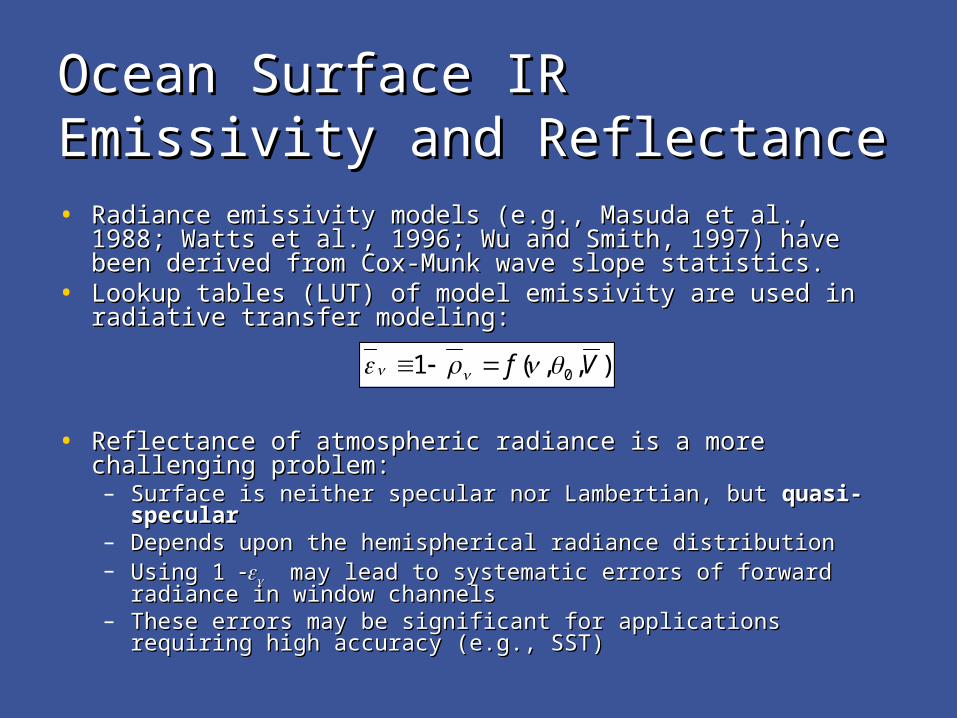
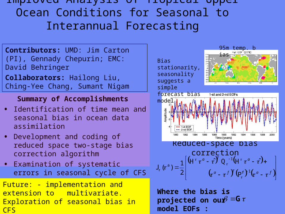
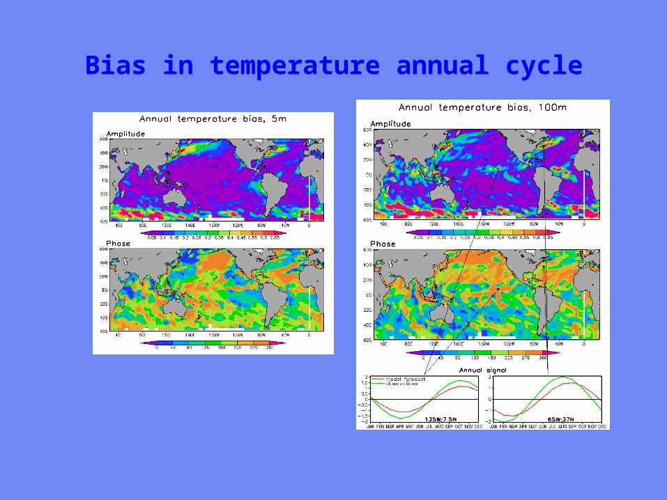
Sea level height errors in models and dataMonte Carlo simulations and spectral distributions
Contributors LDEO AKaplan (PI) MCane (co-PI) TMerlis
Collaborators GMAO ABorovikov MRienecker CKeppenne
Project goal to provide realistic initializations for ocean components of seasonal-to-interannual climate forecast systems by assimilating satellite observations
To achieve this goal we have to investigate the errors of observational and model data sets and the ways to model them statistically
Dynamical simulations of the ocean model error are still quite rare (CaneMillerKaplan et al Fukumori et al Borovikov et al 2005)
Sea level height errors in models and dataMonte Carlo simulations and spectral distributions
Summary of Accomplishmentsbull The AMIP-based ocean ensemble from GMAO
(Borovikov et al 2005) was analyzed and evaluated vs ensembles driven by small-scale noise
bull Ratios of temporal and spatial contributions to the small-scale sea surface height variability were analyzed and used for modeling observational error in monthly tide gauge sea level values wavenumber spectra are used for satellite altimetry error estimates with regards to the model grid size
Contributors LDEO AKaplan (PI) MCane (co-PI) TMerlis
Collaborators GMAO ABorovikov MRienecker CKeppenne
Future Finalizing error estimates ensembles of ocean simulations perturbed by small-scale variability data assimilation implementations
Latitudinal dependence of time evolution of normalized spread in sea surface height for the GMAO ensemble
Theoretical estimatesfor tide gauge error show goodconsistency with the actual errors for all tropical Pacific tide gauge stations but four (known to manifest local effects or phase shifts of Rossby waves)
Summary
From the workshopbull A lot of good progress
bull Collaborations on SST use of aerosol data - collaboration with Clark Weaver (and A da Silva) on aerosol productsinclude emissivityreflectance model in forward model in NCEP radiance assimilation include ocean mixed layer model (Li Harris Rienecker)
bull Collaborations on Assimilation methodology bias estimation (Carton Keppenne) methods to assimilate altimetry - noise models (Kaplan GMAO) ensemble generation (Kaplan GMAO)
Summary
bull Oceanic satellite data assimilation is one of JCSDArsquos mandates
bullSeveral Directed RampD and AO projects supported
bullInfrastructure issues to be addressed
bullKey advances already made
bullCoastalCoral Reef area a clear area for development
Prologue
bull JCSDA is well positioned to exploit the observational data base to be provided by the GOSGEOSS in terms of
bull Assimilation sciencebull Modeling sciencebull Computing power
Generally the next decade of the environmental satellite program promises to be every bit as exciting as the first given the opportunities provided by new observations modern data assimilation techniques improving environmental modeling capacity and burgeoning computer power
The Joint Center will play a key role in enabling the use of advanced satellite data from both current and future advanced systems for environmental modeling
USA Inc and the Global Community will be significant beneficiaries from the Centers activity
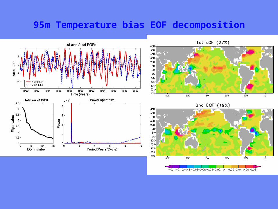
Sea level height errors in models and dataMonte Carlo simulations and spectral distributions
Summary of Accomplishmentsbull The AMIP-based ocean ensemble from GMAO
(Borovikov et al 2005) was analyzed and evaluated vs ensembles driven by small-scale noise
bull Ratios of temporal and spatial contributions to the small-scale sea surface height variability were analyzed and used for modeling observational error in monthly tide gauge sea level values wavenumber spectra are used for satellite altimetry error estimates with regards to the model grid size
Contributors LDEO AKaplan (PI) MCane (co-PI) TMerlis
Collaborators GMAO ABorovikov MRienecker CKeppenne
Future Finalizing error estimates ensembles of ocean simulations perturbed by small-scale variability data assimilation implementations
Latitudinal dependence of time evolution of normalized spread in sea surface height for the GMAO ensemble
Theoretical estimatesfor tide gauge error show goodconsistency with the actual errors for all tropical Pacific tide gauge stations but four (known to manifest local effects or phase shifts of Rossby waves)
Summary
From the workshopbull A lot of good progress
bull Collaborations on SST use of aerosol data - collaboration with Clark Weaver (and A da Silva) on aerosol productsinclude emissivityreflectance model in forward model in NCEP radiance assimilation include ocean mixed layer model (Li Harris Rienecker)
bull Collaborations on Assimilation methodology bias estimation (Carton Keppenne) methods to assimilate altimetry - noise models (Kaplan GMAO) ensemble generation (Kaplan GMAO)
Summary
bull Oceanic satellite data assimilation is one of JCSDArsquos mandates
bullSeveral Directed RampD and AO projects supported
bullInfrastructure issues to be addressed
bullKey advances already made
bullCoastalCoral Reef area a clear area for development
Prologue
bull JCSDA is well positioned to exploit the observational data base to be provided by the GOSGEOSS in terms of
bull Assimilation sciencebull Modeling sciencebull Computing power
Generally the next decade of the environmental satellite program promises to be every bit as exciting as the first given the opportunities provided by new observations modern data assimilation techniques improving environmental modeling capacity and burgeoning computer power
The Joint Center will play a key role in enabling the use of advanced satellite data from both current and future advanced systems for environmental modeling
USA Inc and the Global Community will be significant beneficiaries from the Centers activity

Summary
From the workshopbull A lot of good progress
bull Collaborations on SST use of aerosol data - collaboration with Clark Weaver (and A da Silva) on aerosol productsinclude emissivityreflectance model in forward model in NCEP radiance assimilation include ocean mixed layer model (Li Harris Rienecker)
bull Collaborations on Assimilation methodology bias estimation (Carton Keppenne) methods to assimilate altimetry - noise models (Kaplan GMAO) ensemble generation (Kaplan GMAO)
Summary
bull Oceanic satellite data assimilation is one of JCSDArsquos mandates
bullSeveral Directed RampD and AO projects supported
bullInfrastructure issues to be addressed
bullKey advances already made
bullCoastalCoral Reef area a clear area for development
Prologue
bull JCSDA is well positioned to exploit the observational data base to be provided by the GOSGEOSS in terms of
bull Assimilation sciencebull Modeling sciencebull Computing power
Generally the next decade of the environmental satellite program promises to be every bit as exciting as the first given the opportunities provided by new observations modern data assimilation techniques improving environmental modeling capacity and burgeoning computer power
The Joint Center will play a key role in enabling the use of advanced satellite data from both current and future advanced systems for environmental modeling
USA Inc and the Global Community will be significant beneficiaries from the Centers activity
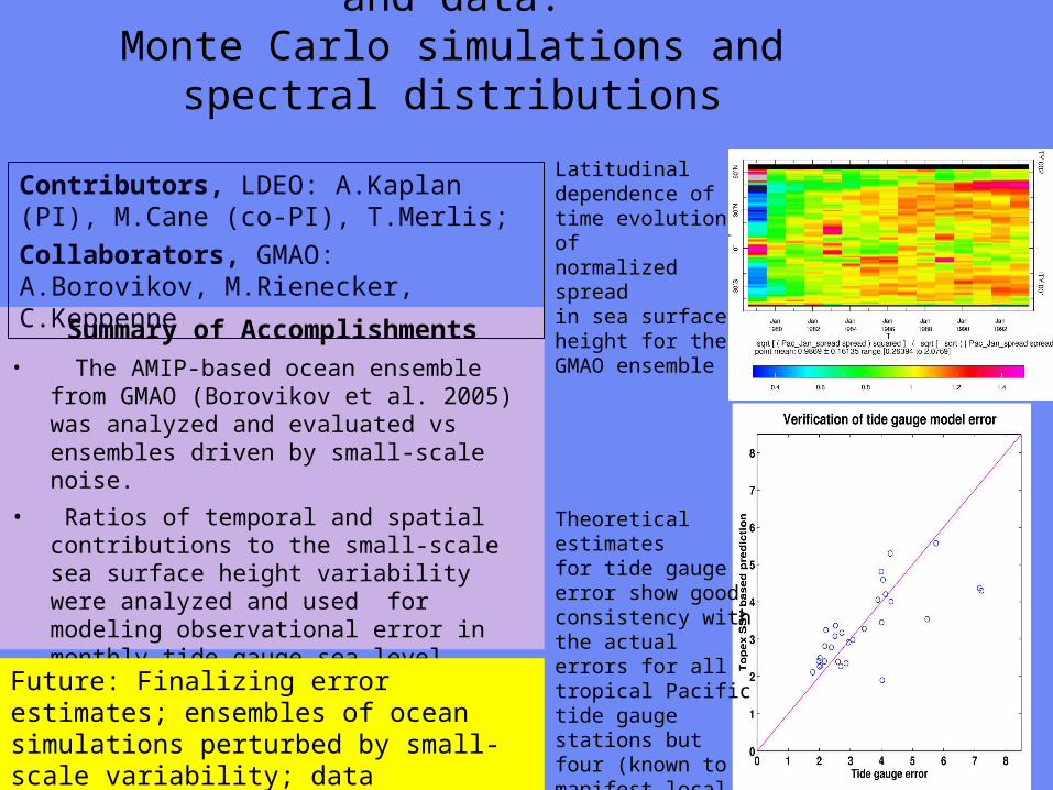
Summary
bull Oceanic satellite data assimilation is one of JCSDArsquos mandates
bullSeveral Directed RampD and AO projects supported
bullInfrastructure issues to be addressed
bullKey advances already made
bullCoastalCoral Reef area a clear area for development
Prologue
bull JCSDA is well positioned to exploit the observational data base to be provided by the GOSGEOSS in terms of
bull Assimilation sciencebull Modeling sciencebull Computing power
Generally the next decade of the environmental satellite program promises to be every bit as exciting as the first given the opportunities provided by new observations modern data assimilation techniques improving environmental modeling capacity and burgeoning computer power
The Joint Center will play a key role in enabling the use of advanced satellite data from both current and future advanced systems for environmental modeling
USA Inc and the Global Community will be significant beneficiaries from the Centers activity
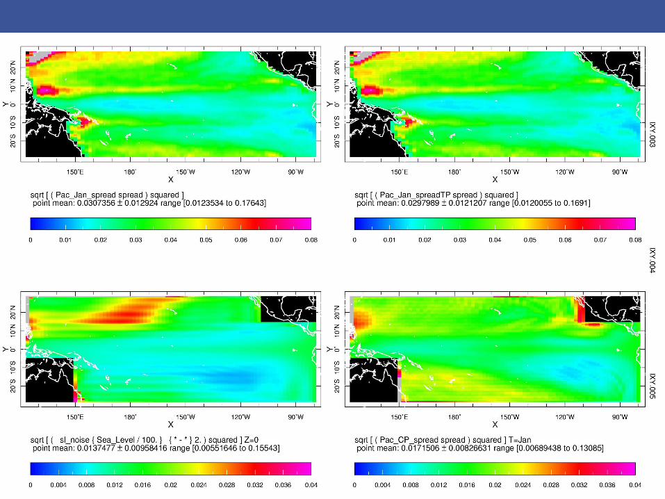