Embed Size (px)
Citation preview

1

Development Brief: Stainbank Green, Kendal. Adopted 29th April 2015
Foreword
This Development Brief has been prepared by South Lakeland District Council in accordance with the Local Plan Land Allocations Development Plan Document to provide guidance, including on layout and design principles, for the development of Stainbank Green. It provides additional guidance on the interpretation of Policy LA2.7 of the South Lakeland Local Plan – Land Allocations (adopted December 2013) which relates to Stainbank Green and other relevant Local Plan policies. It was adopted by South Lakeland District Council on 29th April 2015 as a Supplementary Planning Document and forms a material consideration when determining any planning application submitted for the site.
It provides the development framework for achieving the vision for the site, this is a development fully integrated and accessible in terms of pedestrian/cycle access to the neighbouring Underwood/Stainbank Road residential area and the Vicarage Road Green Wedge, providing new green spaces and green links accessible to all and a design and layout that responds sensitively to the site’s high quality landscape setting and location. It will deliver a mix of well-designed and energy efficient homes that will meet the current and future housing needs of the local community.
This document is to be read in conjunction with South Lakeland District Council’s relevant planning policy documents (including the Adopted Local Plan Land Allocations Document and the Core Strategy).
ALL LINKS IN THIS DOCUMENT HAVE BEEN DEACTIVATED
2

Development Brief: Stainbank Green, Kendal. Adopted 29th April 2015
Contents
1. INTRODUCTION ................................................................................................ 6
1.1 Purpose .......................................................................................................... 6
1.2 Vision ............................................................................................................. 7
1.3 Delivering the Council Plan and local strategies ............................................. 8
1.4 Planning Policy Context .................................................................................. 9
1.5 Sustainability Appraisal (Strategic Environmental Assessment) .................... 11
1.6 Habitats Regulations Assessment ................................................................ 11
1.7 Consultation – Engagement .......................................................................... 11
2. SITE AND SITE CONTEXT .......................................................................... 13
2.1 Site Location ................................................................................................. 13
2.2 Land Use ...................................................................................................... 15
2.3 Landowners/Developer Interest .................................................................... 15
2.4 Planning History ........................................................................................... 15
2.5 Landscape Character ................................................................................... 15
2.6 Topography .................................................................................................. 15
2.7 Views ............................................................................................................ 16
2.8 Existing Natural and Built features on and close to the site ........................... 16
2.9 Accessibility .................................................................................................. 17
2.10 Archaeology and Heritage ............................................................................ 18
2.11 Ground Conditions ....................................................................................... 18
2.12 Noise Considerations ................................................................................... 18
2.13 Flooding Matters – Drainage ........................................................................ 19
2.14 Constraints and Opportunities ..................................................................... 19
3. DEVELOPMENT FRAMEWORK – PROPOSALS AND REQUIREMENTS.. 23
3.1 Development Requirements – Land Allocations DPD ................................... 23
3
Development Brief: Stainbank Green, Kendal. Adopted 29th April 2015
3.2 Sustainability Appraisal ................................................................................. 24
3.3 Land Uses .................................................................................................... 24
3.4 Housing Scale and Form .............................................................................. 27
3.5 Traffic and Movement Strategy ..................................................................... 28
3.6 Landscape/Green Infrastructure Framework ................................................. 34
3.7 Ecology/Biodiversity ...................................................................................... 39
3.8 Flood risk issues - considerations ................................................................. 40
3.9 Noise Impact................................................................................................. 41
3.10 Infrastructure Requirements ......................................................................... 41
3.11 Design Principles ......................................................................................... 42
3.12 Sustainability Principles ............................................................................... 45
3.13 Renewable Energy ...................................................................................... 45
3.14 Sustainable Construction ............................................................................. 46
3.15 Air quality ..................................................................................................... 47
4. IMPLEMENTATION AND DELIVERY .......................................................... 51
4.1 Partners ........................................................................................................ 51
4.2 Phasing/Timing ............................................................................................. 51
4.3 Planning Application ..................................................................................... 51
4.4 Development Obligations .............................................................................. 53
APPENDIX 1: RELEVANT DEVELOPMENT PLAN POLICIES .............................. 57
APPENDIX 2: SOUTH LAKELAND DISTRICT COUNCIL NEW PLAY AREA SPECIFICATION – GUIDANCE .............................................................................. 58
4

Development Brief: Stainbank Green, Kendal. Adopted 29th April 2015
5

Development Brief: Stainbank Green, Kendal. Adopted 29th April 2015
1. INTRODUCTION
1.1 Purpose
1.1.1 This Development Brief is a Supplementary Planning Document providing additional guidance on the interpretation of Policy LA2.7 of the South Lakeland Local Plan – Land Allocations (adopted December 2013) which relates to Stainbank Green and other relevant Local Plan policies.
POLICY LA2.7 STAINBANK GREEN
Purpose: To ensure that the site delivers high quality sustainable development and that landscape, transport, drainage and biodiversity impacts are effectively mitigated.
A DEVELOPMENT BRIEF WILL BE PREPARED TO GUIDE THE DEVELOPMENT OF STAINBANK GREEN.
AS WELL AS OTHER CORE STRATEGY POLICY REQUIREMENTS, DEVELOPMENT MUST MAKE PROVISION FOR THE FOLLOWING:
A LANDSCAPE AND GREEN INFRASTRUCTURE FRAMEWORK WITH A PARTICULAR EMPHASIS ON MITIGATING THE IMPACT ON VIEWS FROM THE NATIONAL PARK AND INTEGRATION WITH THE VICARAGE ROAD GREEN WEDGE;
THE UNDERTAKING OF A DETAILED ECOLOGICAL SURVEY TO DETERMINE THE EXTENT OF MEADOW SAXIFRAGE WITHIN THE NORTH EAST CORNER OF THE SITE AND IMPLEMENTING ACCEPTABLE MITIGATION MEASURES TO ENSURE THE DEVELOPMENT AS A WHOLE ENHANCES THIS HABITAT;
RETENTION OF TREES AND HEDGEROWS;
SUBMISSION AND APPROVAL OF A TRANSPORT ASSESSMENT AND TRAVEL PLAN TO INCLUDE PROVISION OF PEDESTRIAN AND CYCLE LINKS THROUGH THE SITE TO ADJOINING RESIDENTIAL AREAS AND BRIGSTEER ROAD, PROVIDING A FOOTWAY ALONG BRIGSTEER ROAD AND RETAINING AND ENHANCING EXISTING RIGHTS OF WAY. Implementation – Development Brief, Development Management Process Monitoring – Through Local Plan – Core Strategy monitoring framework
6

Development Brief: Stainbank Green, Kendal. Adopted 29th April 2015
1.1.2 The adopted Land Allocations DPD (Development Plan Document) allocates a 10.8 hectare site (gross) on land at Stainbank Green located on the west side of Kendal, for housing development and requires a development brief to be prepared to guide the phasing, distribution of development, layout, design, landscaping and infrastructure (such as roads, open space) for the development of the site.
1.1.3 This Development Brief aims to provide clear guidance for the future development of Stainbank Green. It forms a material consideration in determining planning applications for the site. Its primary purpose is to deliver the vision for the site by:
• providing a development framework, incorporating appropriate designstandards and principles to ensure a high standard of design andsustainability;
• providing a framework for the delivery of traffic and movement,landscape, green infrastructure and other types of infrastructure; and
• setting out a framework for delivery, including planning applicationrequirements.
1.2 Vision
The Vision for Stainbank Green is that the development will
• Be fully integrated and accessible in terms of pedestrian/cycle accessand green infrastructure linkages to the neighbouringUnderwood/Stainbank Road residential area and the Vicarage RoadGreen Wedge.
• Provide well connected new green spaces and green networks,accessible to pedestrians and cyclists providing new recreationalopportunities and wildlife habitats and links between the rest of Kendaland the countryside.
• Deliver a layout, mix and style of housing of a design that respondssensitively to the site’s high quality landscape and edge of Kendal/opencountryside setting, green features and its proximity to the Lake DistrictNational Park.
• Deliver a mix of well-designed and energy efficient homes that will meetthe current and future housing needs of the local community.
7

Development Brief: Stainbank Green, Kendal. Adopted 29th April 2015
1.2.1 The vision for Stainbank Green is to be achieved through the following:
• The creation of five distinctive housing areas (based on the proposedsuggested housing character areas) each providing an individual identityenabling the site to respond positively to its local context and characterand different types of housing design and style;
• By enhancing the ecological value of part of the site through the creationof new areas of open space (for example semi-natural green space) and anetwork of green corridors creating areas of wildlife habitat value;
• The provision of shared formal and informal open space with the widercommunity;
• The creation of a development that is easy to access as well as to movethrough, across and around through the provision of new pedestrian andcycle links integrated with existing rights of way and surrounding roadsand the Vicarage Road Green Wedge. Pedestrian links are required onBrigsteer Road from the site to the Underwood/Brigsteer Road junction;
• Ensuring the new development, whilst being informed by thecharacter and appearance of older properties in close proximity to thesite, provides a mix of designs and styles which expands the housingoffer within Kendal as a whole;
• Providing a range of housing, including affordable housing, that meets theneeds identified for Kendal and the wider area;
• Pedestrian links are required on Brigsteer Road from the site to theUnderwood/Brigsteer Road junction.
• By retaining and enhancing views out of the site towards the southand west through the orientation of development within the site;
• By ensuring the development responds sensitively to the site’s opencountryside setting and high landscape backdrop to the west andsouth through the creation of a soft boundary edge that merges intothe countryside.
• Provide energy efficient homes utilizing methods of sustainableconstruction and renewable energy sources.
1.3 Delivering the Council Plan and local strategies
1.3.1 Delivering the vision for the site through the Development Brief will contribute to the Council’s strategic aims and objectives for South Lakeland as set out in the Council Plan, making it the best place to live, work and explore by:
8

Development Brief: Stainbank Green, Kendal. Adopted 29th April 2015
Supporting the delivery of new homes to meet need • Delivering the specific target of 1,000 affordable homes to rent over
the period 2014-2025;• Enabling of new affordable housing and open market housing through
private sector led developments.
Enabling and delivering opportunities for sustainable economic growth • Enabling sustainable development within Kendal providing
opportunities for housing, and the enhancement of Kendal’s distinctivecharacter and offer.
• Helping towns and villages to thrive commercially whilst retaining theirdistinctive character.
Protecting the environment • Ensuring that the design and layout of development respects Kendal
and its surrounding high quality environment, including the LakeDistrict National Park and its setting, and makes a positive contributionto the quality of life of the area’s residents;
• Encouraging the best standards for new development, demonstratingquality and sustainability.
Improving health and reducing health inequalities • Ensuring that the area remains a safe place to live;• Supporting the creation of new green spaces and green networks
integrated with the Stainbank Road/Underwood housing areas and theVicarage Road Green Wedge to be enjoyed by new and existingresidents.
1.3.2 Delivering the vision for the site will also contribute to the area strategy for Kendal, as set out in the Core Strategy which seeks the delivery of new housing (including affordable housing) and employment land to meet the needs and aspirations of the local community. The provision of new green corridors with pedestrian and cycle access will also help support key priorities set out in the Cumbria Local Transport Plan 2011 – 2026, which includes enabling opportunities for more people to walk and cycle.
1.4 Planning Policy Context
1.4.1 This section sets out the current adopted planning policy context for the site and other legislation to be considered.
1.4.2 The Development Brief is required to be in accordance with the adopted planning policy context relevant to the site, together with other legislation as appropriate. In this regard, the current ‘Development Plan’ for South Lakeland (outwith the two National Parks), comprises:
• Local Plan - Core Strategy DPD (adopted October 2010) – theadopted Core Strategy identifies a requirement for 8,800 homes to
9

Development Brief: Stainbank Green, Kendal. Adopted 29th April 2015
be delivered across South Lakeland within the plan period (2010-2025). It requires about a third of this requirement to be met within Kendal, one of the principal service centres within the District. Relevant policies contained within the adopted Core Strategy are included in Appendix 1 to this brief;
• Local Plan – Land Allocations DPD (adopted December 2013) –this allocates a site at Stainbank Green for around 189 dwellings(policy LA1.3) and requires the preparation of a development brief(paragraph 2.77). It also includes a site specific policy (LA2.7)relating to the site. The suggested number of dwellings is not afixed target; it is based on broad assumptions about the site’spotential capacity;
• South Lakeland Local Plan 2006 - & Alterations (finalcomposite plan) published September 2007 – This combines theLocal Plan adopted in 1997 and the alterations to the Local Planadopted in March 2006. The Local Plan 2006 contains a number ofsaved and extended policies of relevance to the development of thesite. See Appendix 1 to this brief;
• Cumbria Minerals and Waste Local Plan (adopted April 2009) –this sets out how Cumbria’s sustainable minerals and wastemanagement developments that will be needed in Cumbria by 2020and beyond will be planned.
1.4.3 The above documents form the current development plan for South Lakeland and any planning application must be shown to be in accordance with them. The Development Brief must also be in accordance with these documents. In addition any planning application must be shown to be in accordance with the National Planning Policy Framework.
1.4.4 National Planning Policy Framework (March 2012) – This is a material planning consideration in planning decisions. It sets out the Government’s planning policies for England and how these are expected to be applied. This includes the need to boost significantly the supply of housing (paragraph 47) and the need to deliver a wide choice of high quality homes, widen opportunities for home ownership and create sustainable, inclusive and mixed communities (paragraph 50). The new National Planning Practice Guidance was published on 6 March 2014. Both are available to view on the .gov website.
1.4.5 South Lakeland District Council intends to introduce the Community Infrastructure Levy (CIL) in 2015. When it is adopted developers will be required to pay a sum of money to the Council which will be used to provide or improve infrastructure in the local area.
10

Development Brief: Stainbank Green, Kendal. Adopted 29th April 2015
1.5 Sustainability Appraisal (Strategic Environmental Assessment)
1.5.1 The Stainbank Green site has already been subject to Sustainability Appraisal as part of the site assessment process in preparing the Land Allocations document. It is therefore not necessary to undertake further Sustainability Appraisal of the Development Brief. This approach has been approved by the three statutory bodies, Natural England, the Environment Agency and English Heritage. Key findings from the Land Allocations DPD’s Sustainability Appraisal for Stainbank Green site has been used to help inform the Brief, these are referred to in Section 3.
1.6 Habitats Regulations Assessment
1.6.1 Assessment is required under the Habitat Regulations of the potential impact of development plans on sites of international nature importance. The Stainbank Green site was assessed in this way as part of the Land Allocations process. No likely significant effects were found.
1.7 Consultation – Engagement
1.7.1 The Council has undertaken extensive public and stakeholder engagement and consultation in preparing the Development Brief. Details of the comments received through the consultation/engagement process, and how the preparation of the Brief has taken account of them can be found in the Consultation Statement. A key component of this engagement was a drop-in event held at Kendal Town Hall on 20th March 2014 which was attended by around 120 people and a further event held at the Shakespeare Centre, Kendal on the 13th November 2014 attended by around 210 people.
1.7.2 Examples of how key issues raised have been used to inform the Development Brief are:
• Importance of retaining existing public rights of way on the site and forthese to be incorporated into green corridors– the development briefincludes requirements to retain these as green corridor linkagesforming part of the green infrastructure network.
• Support for new habitat creation within the site and other types of openspace – the development brief includes requirement for new greenspace with multi-functional purpose including the provision of asignificant area of semi-natural public green space on the southern /southeastern part of the site.
• The need to ensure development respects existing rural edge settingand character, with built form of an appropriate scale. The
11

Development Brief: Stainbank Green, Kendal. Adopted 29th April 2015
Development Brief includes general design principles that make explicit the need for the scale and form of development to respect existing character and the edge of Kendal setting.
• Need for new pedestrian and cycle links to Kendal Town Centre andthrough the site. The Development Brief includes provision of newcycle and pedestrian links to neighbouring housing area and a footwayalong Brigsteer Road to its junction with Underwood.
• Concerns about use of Cedar Grove as a main vehicular access point.The Development Brief specifies an emergency access only ontoCedar Grove.
12
Development Brief: Stainbank Green, Kendal. Adopted 29th April 2015
2. SITE AND SITE CONTEXT2.0 This section sets out and assesses the site and its context in terms of
location, land use, planning history, accessibility and site characteristics. Itthen explores the constraints and opportunities for the site taking thesefactors into account.
2.1 Site Location
2.1.1 The site is located on the west edge of Kendal, approximately 1 km (as the crow flies) from Kendal Town Centre. It is bounded by open countryside to the west and south, residential development to the east and a cluster of residential properties to the west (Stainbank Green) and public open space to the south east. Further to the west of the site lies the A591 Kendal Bypass and beyond lies the Lake District National Park. It is bounded to the north by Brigsteer Road (see figure 1.1).
13

Development Brief: Stainbank Green, Kendal. Adopted 29th April 2015
14
Development Brief: Stainbank Green, Kendal. Adopted 29th April 2015
2.2 Land Use
2.2.1 The majority of the site consists of grassland currently used for agricultural purposes including sheep and cattle grazing. There are no buildings on the site. A small part of the site close to the ‘Stainbank Green’ properties is currently used for domestic curtilage/paddock purposes. It contains two public rights of way providing an important recreation function.
2.3 Landowners/Developer Interest
2.3.1 The site is held in three separate ownerships as follows (based on information at this point in time):
• One landowner owns the north part of the site; the area betweenBrigsteer Road and public right of way from Underwood to thelane/road providing access to properties at ‘Stainbank Green’. StoryHomes Ltd has an interest on this part of the site.
• One landowner owns the majority of the remainder of the site withthe exception of the field immediately to the east of the properties at‘Stainbank Green’. Russell Armer Homes has an interest on thispart of the site.
• One landowner owns the field immediately to the east of theproperties at ‘Stainbank Green’.
2.4 Planning History
2.4.1 There is no planning history (within last 5 years) affecting the site in terms of previous applications for new development.
2.5 Landscape Character
2.5.1 Within the Cumbria Landscape Character Appraisal Tool Kit the site lies within Character Type 3a – Coastal Limestone. Open Farmland and Pavements. The site exhibits some of the characteristics associated with this type i.e. strong field patterns demarcated by dry stone walls and pockets of scrub and deciduous woodland. In such areas support should be given to the retention of tree cover and field boundaries. Developments should respect traditional form.
2.6 Topography
2.6.1 The site is sloping in aspect (see Figure 1.1) and gradually falls from north west to south east. It has a crossfall in excess of 40m ranging from around 125 metres above sea level in the north-west corner to around 85 metres above sea level in the south-east corner. It contains steep aspects on the far
15

Development Brief: Stainbank Green, Kendal. Adopted 29th April 2015
NE part of the site and to a lesser extent close to the play area at the end of Maple Drive and through the SE part of the site.
2.7 Views
2.7.1 The site is prominent in views to various degrees from surrounding residential areas, roads and rights of way. The southern portion is less concealed than the remainder of the site and is especially prominent in the local and wider landscape being conspicuous in view from the A591 and higher ground to the west as well as in distant views from parts of Kendal to the SE and East. The northern and eastern parts of the site are more concealed in wider views due to intervening development, woodland and topography. Large parts of the site are visible in view from the footpaths which run through the site and along its NE and NW boundary. A number of residential properties to the east of the site have views of varying degrees of part of the site, especially those properties that back onto the site off Cedar Grove, Maple Drive and Aldercroft. Properties to the west (‘Stainbank Green’) have views of parts of the central part of the site. Properties to the NE of the site (Ghyll Brow) have an open aspect onto the NE part of the site. The northern most part of the site is visible from ‘The Ghyll’ property and will be highly visible from the South of Underbarrow Road new development.
2.8 Existing Natural and Built features on and close to the site
Natural
2.8.1 The site largely comprises open fields used for grazing. It includes hedgerows and many trees. Figure 1.2 highlights which trees are covered by Tree Preservation Orders. The site is bounded to the east by an area of mature woodland with a Tree Preservation Order. The central southern portion of the site contains a watercourse which is not identified on OS maps that flows down to the area of public open space/woodland located to the south east of the site (part of the Vicarage Road Green Wedge).
Built
2.8.2 There are no buildings on the site. A number of electricity pylons traverse the far northern part of the site and also the central western part of the site. Dry stone walls form the boundary of the site as well as the field boundaries within the site. The east boundary is in parts bounded by residential properties and their curtilages (Maple Drive, Cedar Grove and Aldercroft). These properties comprise a mix of 1 and 2 storey houses (bungalows, detached and semi-detached). A play area separates Maple Drive and the site. To the NE of the site beyond the mature trees and public right of way are properties (Ghyll Brow) of 3 storeys older and different in character to the housing described above. To the west of the site is located a group of properties (‘Stainbank
16

Development Brief: Stainbank Green, Kendal. Adopted 29th April 2015
Green’). The SE tip of the site is bounded by residential properties off Collin Hill.
2.9 Accessibility
Road Access
2.9.1 Brigsteer Road bounds the site’s northern boundary this provides a link into Kendal Town Centre to the east and Brigsteer Village to the west.
2.9.2 A road/lane adjoins the NW boundary providing access to residential properties at ‘Stainbank Green’; this links onto Brigsteer Road and forms part of a public right of way.
2.9.3 The eastern part of the site adjoins a residential area which includes a number of cul-de-sacs (Maple Drive, Cedar Grove, Aldercroft); these feed off Stainbank Road, a stone wall separates Cedar Grove and the site. There is no vehicular access into the site from either Maple Drive or Cedar Grove.
Rail Access
2.9.4 Kendal Railway Station is located just over 2 kms from the centre of the site (as the crow flies) and can be accessed via Brigsteer Road and Kendal Town Centre routes. It provides direct rail links to Windermere and Oxenholme and occasionally Lancaster, Preston and Manchester. Oxenholme Railway Station is located about 3kms from the centre of the site (as the crow flies) and can be accessed through Underwood and Stainbank Road.
Bus Provision
2.9.5 Local Bus service 46, running to and from the town centre operates every hour Monday - Saturday until around 6pm and serves the Stainbank Road/Underwood and Collinfield residential area. There is a bus stop on Stainbank Road roughly 250 metres from the centre of the site and on Collin Field roughly 550 metres from the centre of the site (as the crow flies).
Cycle Access
2.9.6 The immediate local area does not have any dedicated/off-highway cycle lanes.
Pedestrian Access / Public Rights of Way (PRoW)
2.9.7 There are public rights of way within and adjacent to the site as follows:
17

Development Brief: Stainbank Green, Kendal. Adopted 29th April 2015
• Parallel to the north east boundary of the site providing a linkbetween residential areas to the east (Underwood/Stainbank Road)and Brigsteer Road.
• Traversing the northern part of the site providing a link betweenresidential area to the east and the road leading to properties at‘Stainbank Green’ and onto Brigsteer Road
• Traversing the central and west part of the site providing a linkbetween the residential areas to the east from Stainbank Road toBrigsteer Road via the road/ lane to the North West of the siteserving properties at ‘Stainbank Green’.
2.9.8 There is no footway on the southern side of Brigsteer Road where it adjoins the site. The lane adjoining the NW boundary of the site contains no footway. There are footways on either side of Maple Drive and Cedar Grove.
2.10 Archaeology and Heritage
2.10.1 There are no scheduled ancient monuments, registered historic parks and gardens, registered battlefields or conservation areas within the site or its immediate vicinity. There are no listed buildings/structures recorded within it or in close proximity. Based on County Council advice, earthworks of agricultural remains from an unknown period survive on the site and the possible line of a Roman road lies on the northern boundary. In line with the National Planning Policy Framework and Local Plan policy, any forthcoming planning application should include an archaeological desk-based assessment and evaluation, in this instance a geophysical survey.
2.11 Ground Conditions
2.11.1 No contamination is either recorded or suspected on the site. However, given the future residential use on the site, a preliminary risk assessment will be carried out in support of any planning application with a full site investigation to follow if the site possesses a potentially significant risk.
2.12 Noise Considerations
2.12.1 The western part of the site is very close to the A591 Kendal By-pass. The layout and design of the development will need to address any potential noise impacts from this source. As part of the planning application a noise impact assessment will be required and appropriate measures put in place to offset any likely adverse impacts.
18

Development Brief: Stainbank Green, Kendal. Adopted 29th April 2015
2.13 Flooding Matters – Drainage
2.13.1 The site lies within Flood Risk Zone 1, with both the Environment Agency and South Lakeland District Council’s Environment Protection confirming that, based on previous history and existing evidence (surface water flooding data and local records) there are no known surface water flooding problems/issues. There is evidence of a watercourse located on the southern half of the site – a temporary feature which drains towards the Vicarage Road Green Wedge. Due to the size of the site, a Flood Risk Assessment will be prepared and submitted in support of any planning application which will confirm that surface run-off will not exceed existing greenfield run-off rates including an allowance for climate change.
2.14 Constraints and Opportunities
2.14.1 In response to the site’s context and characteristics assessed earlier in this section, constraints and opportunities have been identified which have informed and influenced the proposals for the site – these are mapped in Figure 1.2.
Constraints
2.14.2 The following constraints have been identified.
• Sensitive edges with existing houses. The eastern edge of the sitebounds a number of residential properties and their curtilages. Theseproperties have varying degrees of outlook onto the site. A smallcluster of properties to the west of the site (Stainbank Green) alsohave varying degrees of outlook onto part of the site. Properties to theNE part of the site (Ghyll Brow) have an open aspect of the NE part ofthe site which is steep in nature. The layout, design and siting of newdevelopment will need to be sensitive to existing levels of residentialamenity with issues relating to the potential for visual impact andoverlooking/privacy to be addressed through consideration of the scaleof dwellings on these common boundaries. The introduction oflandscaping/buffers where appropriate and the separation distancesbetween the existing properties will help to minimise impact onresidential amenity afforded to these properties.
• Long distant views of the site from higher ground to the westespecially of the southern part of the site and from the Lake DistrictNational Park. Careful consideration needs to be given in the layoutand design and positioning of development so it is sensitive to the high
19

Development Brief: Stainbank Green, Kendal. Adopted 29th April 2015
quality landscape setting and proximity to Lake District National Park as well as open aspect.
• Varied topography; the site is sloping in aspect with steep sections inplaces especially the far NE part of the site and land close to the PlayArea at the end of Maple Drive.
• Presence of Meadow Saxifrage on the NE part of the site; this mayhave implications for the layout of development on this part of the siteand also ecological considerations across the site as a whole;
• Edge of Kendal/Open countryside setting/High quality landscapesetting; the site merges into the open countryside on its southern andwestern boundaries and very careful consideration needs to be givento the interrelationship of any new building and the countryside inorder to achieve an appropriate transition between the built up areaand the adjoining landscape;
• Drainage; the south east part of the site is of lower elevation and thereis evidence it performs a function as a natural channel for water tocollect and drain outwards into the Vicarage Drive Green Wedge areato the SE of the site; this has possible implications for identifyingflooding/drainage considerations on this part of the site;
• Overhead Electricity lines; these traverse the northern and west partof the site – ideally these should be located underground;
• Natural features of high value to be retained where possible andappropriate; the site contains/adjoins a number of trees with TreePreservation Orders, these features alongside stone walls andhedgerows will need to be integrated within the layout and design ofthe site wherever possible.
Opportunities
2.14.3 The site offers the following opportunities:
• Opportunity to maintain and enhance existing woodland, trees,hedgerows and stone walls where possible and appropriate onand adjacent to the site through incorporating these features within thelandscape structure/green infrastructure framework and traffic andmovement framework, and to provide important natural habitat forwildlife.
• Opportunity to enhance ecological habitat of part of the sitethrough creation of new green spaces with wildlife habitat valueincluding an area of semi natural green space on the southern part ofthe site integrated with the Vicarage Drive Green Wedge.
20

Development Brief: Stainbank Green, Kendal. Adopted 29th April 2015
• Opportunity to improve quality and amount of open space provisionin the immediate area particularly play provision providing benefits tothe wider community through enhancing informal recreation/leisureopportunities.
• Opportunity to enhance pedestrian and cyclist permeability tosurrounding area – retaining existing rights of way and providing newlinks to surrounding residential development and open space andintegrating these so they form part of the green infrastructure andtraffic and movement framework.
• Opportunity for vehicular access from Brigsteer Road via theroad/lane providing access to Stainbank Green where it joins BrigsteerRoad. This will be the main point of access into the site. There is alsoa vehicular access opportunity from Cedar Grove, but this would be foremergency access only.
• Opportunity for design and layout of the development to retain thestrong field patterns with well-defined field boundaries to help break upmassing through introduction of distinctive character areas. Kendal ismade up of different styles of urban design. There is a need for thedesign and layout to respect nearby existing built form and landscapesetting whilst introducing its own character and variety of style.
• Opportunity to integrate new development into the existing residentialareas.
• Use of green roofs and walls to support drainage systems andminimise landscape impact and enhance the green infrastructureframework.
• Utilising sloping and elevated topography to benefit from extensiveviews to the south and east and solar energy/gain.
• Make public areas and movement routes accessible and interesting byincorporating features such as interpretation panels relating to keyfeatures of the site/area or views and signposting to key destinations.
21

Development Brief: Stainbank Green, Kendal. Adopted 29th April 2015
22

Development Brief: Stainbank Green, Kendal. Adopted 29th April 2015
3. DEVELOPMENT FRAMEWORK – PROPOSALSAND REQUIREMENTS
3.1 Development Requirements – Land Allocations DPD
3.1.1 Stainbank Green site will be developed in accordance with the requirements set out in Policy LA2.7:
POLICY LA2.7 STAINBANK GREEN
Purpose: To ensure that the site delivers high quality sustainable development and that landscape, transport, drainage and biodiversity impacts are effectively mitigated.
A DEVELOPMENT BRIEF WILL BE PREPARED TO GUIDE THE DEVELOPMENT OF STAINBANK GREEN.
AS WELL AS OTHER CORE STRATEGY POLICY REQUIREMENTS, DEVELOPMENT MUST MAKE PROVISION FOR THE FOLLOWING:
A LANDSCAPE AND GREEN INFRASTRUCTURE FRAMEWORK WITH A PARTICULAR EMPHASIS ON MITIGATING THE IMPACT ON VIEWS FROM THE NATIONAL PARK AND INTEGRATION WITH THE VICARAGE ROAD GREEN WEDGE;
THE UNDERTAKING OF A DETAILED ECOLOGICAL SURVEY TO DETERMINE THE EXTENT OF MEADOW SAXIFRAGE WITHIN THE NORTH EAST CORNER OF THE SITE AND IMPLEMENTING ACCEPTABLE MITIGATION MEASURES TO ENSURE THE DEVELOPMENT AS A WHOLE ENHANCES THIS HABITAT;
RETENTION OF TREES AND HEDGEROWS;
SUBMISSION AND APPROVAL OF A TRANSPORT ASSESSMENT AND TRAVEL PLAN TO INCLUDE PROVISION OF PEDESTRIAN AND CYCLE LINKS THROUGH THE SITE TO ADJOINING RESIDENTIAL AREAS AND BRIGSTEER ROAD, PROVIDING A FOOTWAY ALONG BRIGSTEER ROAD AND RETAINING AND ENHANCING EXISTING RIGHTS OF WAY. Implementation – Development Brief, Development Management Process Monitoring – Through Local Plan – Core Strategy monitoring framework
23

Development Brief: Stainbank Green, Kendal. Adopted 29th April 2015
3.2 Sustainability Appraisal
3.2.1 In addition, the Sustainability Appraisal carried out for the site at Stainbank Green found that the site scored generally well in sustainability terms overall (though averagely in comparison to other sites in Kendal). Areas of impact that the SA highlighted as requiring particular attention were: air quality and impact on the landscape; biodiversity; the need to integrate the site into Kendal, the take up of a large area of greenfield land; the need to integrate renewable/low carbon/decentralised energy sources into the site and maximising use of recycled materials and minimising waste.
3.2.2 A contribution to overcoming these issues can be made by addressing specific measures in the Development Brief. These should include preparing a travel plan and ensuring that there are foot and cycle links to and within the site to make access to nearby facilities/town centre as short and easy as possible. The creation of a multi-functional green infrastructure framework that supports recreation, biodiversity, landscape character and climate change adaptation and mitigation; retention of greenfield run-off rates by minimising non-permeable surfaces and ensuring good drainage design; ensuring that the layout and design give the site the feel of being part of and integrated with residential areas to the west and neighbouring roads; taking the character of Kendal into account in the proposed layout/design; making comprehensive and integrated enhancements to existing open space provision, recycling provision and incorporating renewable/low-carbon and/or decentralised energy sources within the development.
3.3 Land Uses
Land Uses
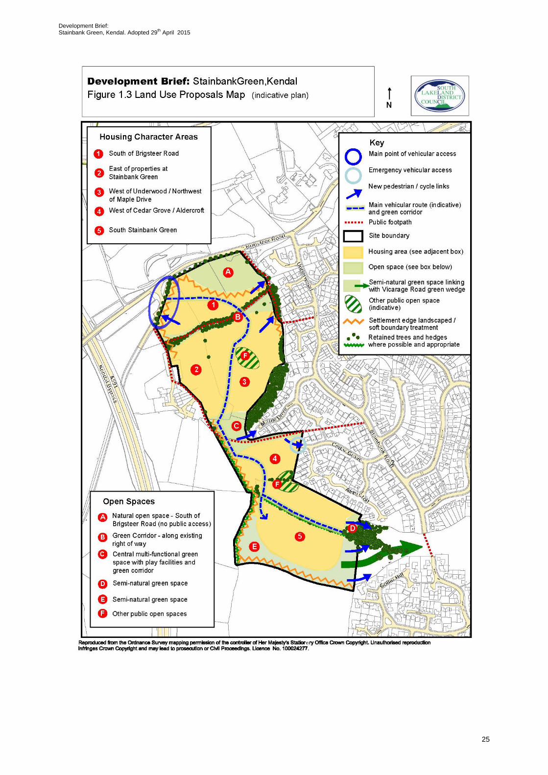
3.3.1 The site will be for residential use. Other parts of the site will be used for a public open space and play provision. The indicative Land Use Proposals Map (figure 1.3) sets out the land uses at Stainbank Green with an indication of where the main vehicular route from Brigsteer Road into the site could be located and how the development will respond and cater for cyclists and pedestrians through a connected network of footpaths and cycle routes to the nearby residential areas and surrounding area. It also identifies the location of proposed housing character areas and green spaces to inform specific design and layout principles.
Note. The proposals map at figure 1.3 is an indicative plan. The detail of the final site layout for development will be determined at the planning applications stage. It sets out essential elements of the green infrastructure/landscape framework and traffic and movement framework for the site and shows the appropriate balance between developable and non-developable areas in this context.
24
Development Brief: Stainbank Green, Kendal. Adopted 29th April 2015
25

Development Brief: Stainbank Green, Kendal. Adopted 29th April 2015
Housing Character Areas
3.3.2 The site will be designed and laid out using a series of character areas in order to ensure the design and layout of development responds positively to the local context and different site features creating interest and difference in style. The Character Areas suggested are referred to as the following (see Figure 1.3 and Design and Layout Principles for more details).
1 South of Brigsteer Road 2 East of properties at Stainbank Green 3 West of Underwood/North West of Maple Drive 4 West of Cedar Grove / Aldercroft 5 South Stainbank Green (located to the south of the hedgerow)
Housing Requirements
3.3.3 The Stainbank Green site will provide a mix of housing types, sizes and tenures based on local evidence base (current at the time any proposal is made) and viability considerations and subject to further discussions with the District Council. This mix will be provided to create choice, varied building forms and to help respond to the different character of the different parts of the site and its local context. House types should be influenced by site-specific considerations. For example development of a different scale and form will be necessary on the site in order to achieve a positive layout that respects existing character, context, residential amenity and topography.
Affordable Housing
3.3.4 In accordance with Policy CS6.3 of the Core Strategy, no less than 35% of the total number of dwellings must be affordable subject to viability. The Council would expect a wide range of different dwelling types to meet evidenced affordable housing needs. Affordable houses will be mixed/pepper-potted throughout the development. Developers should follow the Council’s Affordable Housing Guidance for Developers which is updated annually.
Open Market Housing
3.3.5 An analysis of general market supply and demand for open market housing (Table 4.5 page 69 of the 2014 Strategic Housing Market Assessment) suggests shortfalls in detached properties, bungalows and properties with four or more bedrooms in Kendal.
Self-Build Properties
3.3.6 The Council is supportive of self-build projects and encourages an element of this type of property as part of the overall mix.
26

Development Brief: Stainbank Green, Kendal. Adopted 29th April 2015
Housing Technical Standards Review
3.3.7 The outcome of the Government’s housing technical standards review was set out in the Planning Written Ministerial Statement 25 March 2015. This affects the types of technical standards local authorities can apply to new housing. The government has withdrawn the Code for Sustainable Homes. Under the review, Local Authorities will be able to apply additional optional Building Regulations on water and access through new adopted local plan policies. A new nationally described space standard has also been introduced.
3.3.8 Any planning application decisions on the site will be subject to standards set within adopted Local Plan policy and relevant National policies at the time they are made. Under current adopted Local Plan policy new residential development will be required to meet standards in line with those set in current Building Regulations. However, the Council will continue to encourage development that promotes a high standard of sustainable construction and energy efficiency above and beyond current mandatory standards set within Building Regulations (see paras 3.12 - 3.14).
3.3.9 The Council continues to encourage the design of a proportion of homes to Lifetime Homes standard and in particular the provision of:
• Ground floor accommodation which can be converted to shower facilities;
• Straight stairway to facilitate the provision of stair lifts.
3.4 Housing Scale and Form
3.4.1 The scale, massing and form of development will need to be sensitive to existing local built and settlement form, local character and setting; this will
Housing Requirements at Stainbank Green:
A range of house types and tenures will be provided. Self-build properties and the provision of bungalows will be supported and encouraged as part of the overall mix.
Subject to viability, no less than 35% of the total number of dwellings must be affordable and these will be mixed/pepper-potted within the scheme.
Developers should follow the Council’s Affordable Housing Guidance for Developers (note it is updated annually)
27

Development Brief: Stainbank Green, Kendal. Adopted 29th April 2015
help inform appropriate housing density for the site. A range of housing densities will be appropriate, when combined with landscape and building form, this will assist in providing areas of recognisable character and reinforce a sense of place and provide legibility to the scheme. Given the need to ensure a more gradual transition and a soft interface between the developed edge of Kendal and the countryside beyond, development along the northern, western and southern edges will be of a reduced scale and form/massing.
3.5 Traffic and Movement Strategy
3.5.1 The following key considerations need to be made in the context of the outcome of any future Transport Assessment and advice provided by Cumbria County Council Highways at the planning application stage. The design of roads, footways, footpaths and cycleways must accord with the adoptable standards set out within the Cumbria Design Guide. Principles established in the ‘Manual for Streets 1 and 2’ guidance should be used to inform the layout and design of streets within the site. The Cumbria Design Guide is currently under review and is very much based on the principles in the Manual for Streets 1 and 2. Where Manual for Streets is to be used this needs to be evidenced-based.
3.5.2 The layout and design of Stainbank Green will encourage the use of alternative modes of transport. It will also ensure the development is connected to the neighbouring residential areas (Stainbank road/Underwood/Collinfield), rest of Kendal (via Brigsteer Road) and surrounding countryside and open spaces (Vicarage Drive Green Wedge) by building on existing pedestrian links and creating new pedestrian/cycle links to deliver a strong network of pedestrian and cycle routes. It is essential that the road layout provides clear, legible, direct routes and promotes a safe and accessible movement framework for all (see figure 1.3).
Note. The map at figure 1.3 is an indicative plan. The detail of the final site layout for development will be determined at the planning applications stage following discussions with Cumbria County Council (Highways Authority).
Vehicular Access into and through the site
3.5.3 The main (sole) point of vehicular access for general traffic movements to Stainbank Green will be taken from Brigsteer Road to the north of the site. A secondary access is not required. An access off Brigsteer Road other than from the NW point of the site (utilising the road/lane junction with Brigsteer Road) as shown on figure 1.3 proposals map would result in harmful visual impacts and result in detrimental landscape impact. The exact location and detailed design of the access will be agreed with Cumbria County Council and determined through the planning application. Careful consideration must be
28

Development Brief: Stainbank Green, Kendal. Adopted 29th April 2015
given to existing access/egress arrangements at the road/lane junction with Brigsteer Road.
3.5.4 An emergency access should be provided from Cedar Grove. Cumbria County Council specifies the driveway route should be a minimum of 3.7m wide. The opening to such an access must be restricted with collapsible bollards and a dropped crossing should be put in place prior to the opening, however, it could be used as a segregated pedestrian/cycle route.
3.5.5 A main road will serve the whole site on a North – SE axis (see Figure 1.3 indicative route shown). A hierarchy of streets will be designed to create a low-speed, well connected movement framework which is easy to move within and through. The streets should be fronted by houses to avoid blank fronts and ensure active frontages are created. Within the housing areas, the streets will be designed to control traffic speeds. The best way to do this is to design streets that encourage people to drive with caution to below 20mph and are effectively traffic calmed.
3.5.6 Brigsteer Road where it bounds the site is currently national speed limit (60mph). It is a requirement of any development in particular sites that have a frontage on such highways that no development shall commence until the adjacent highway transition of the national speed/30 mph limit has been relocated beyond the main access junction (details to be agreed). The details must be submitted to the Local Highway Authority for approval. A speed limit review should be carried out that relocates the existing 60mph/30mph limit sufficiently beyond the western site access entrance position to be agreed with Cumbria County Council Traffic Management Unit.
3.5.7 Proposals will take a balanced approach to movement and provide for the needs of all users of the streets and spaces, not just the needs of vehicles. Safe access for pedestrians and cyclists must be provided. The design and layout will ensure that main routes are easy to recognise and follow. Cul-de-sacs should normally be avoided in context of permeability unless particular site conditions dictate that a cul-de-sac design is the most appropriate way to develop the site. Additionally, the road layout should incorporate loops wherever feasible to ensure that there is always more than one route option in the event that a section of the main road/street becomes blocked.
3.5.8 Shared surface streets in which there is no kerb to separate the carriageway from the footway may be appropriate. These work best in relatively calm traffic environments, however, they should be designed to accommodate the needs of visually impaired people for whom they can be problematic.
3.5.9 Proposals should consider and ensure provision for road access beyond the site in future years, even if this now seems unlikely.
29

Development Brief: Stainbank Green, Kendal. Adopted 29th April 2015
Public transport
3.5.10 Existing bus Service 46 currently operates along Brigsteer Road/ Underwood and Stainbank Green and to the south east of the site along Collin Field. The majority of the site is within 400 metres (as the crow flies) of either or both of these bus stops; however, a small portion of the far SW part of the site is just outside this threshold. Consideration should be given to enabling the easiest possible pedestrian and cycle access from the site to these existing bus stops. The benefits of altering the bus route to take in the site are desirable and should be explored through the Transport Assessment and the Travel Plan. Community Transport Schemes should also be considered as a means of providing transport for people living on the site.
Pedestrian and cycle access and green corridors
3.5.11 New pedestrian and cycle links will be incorporated into the layout and design of the site taking into account all possible connections to surrounding areas to ensure that the site is comprehensively connected as possible. New cycle and pedestrian links should be provided from the housing development to the new green spaces on the site and also the surrounding roads (Brigsteer Road, Maple Drive and Cedar Grove), rights of way and the Vicarage Road Green Wedge. These routes will be designed to be safe and pleasant with high levels of natural surveillance and be accessible to all including those with impaired mobility or vision. They should avoid being located to the rear of properties. Cycle routes and footpaths should be separate from vehicle routes where possible and appropriate unless they lack passive surveillance from surrounding buildings. There is the opportunity for the main road through the site to have a green corridor function, i.e. a footway/cycleway to be provided alongside the road separated by a green area.
3.5.12 Green corridors should form an integral part of the transport and movement framework as well as the green infrastructure framework as appropriate. These would generally comprise a footpath and in some cases also a cycleway separated from the carriageway by a green linear space. They may also be located within a separate open space and in some cases utilise existing rights of way.
3.5.13 In some cases it may be appropriate for the ‘main vehicular route(s)’ serving the site to perform a green corridor function i.e. whereby a footpath/cycleway is separated from the edge of the carriageway at least on one side by a green area. It may be appropriate to change from footway to footpath (a discontinuous separation from the carriageway), meaning the route has a partial green corridor function. The footpath/cycleway will need to be built to adoptable standards.
3.5.14 Away from roads green corridors providing linkages between housing areas and open spaces/key facilities, may be appropriate. Those of a strategic function (that follow pedestrian desire lines) i.e. provide linkages through the
30

Development Brief: Stainbank Green, Kendal. Adopted 29th April 2015
site to neighbouring areas, roads and facilities footpaths should be built to adoptable standards.
3.5.15 It would be desirable to seek improvements where feasible to the existing footpath bounding the NE boundary of the site connecting to Underwood in order to provide a more attractive, safe and user friendly means of access.
3.5.16 To satisfy policy requirements, safe pedestrian access must be provided to/along Brigsteer Road. To ensure there is continuous safe pedestrian access along Brigsteer Road this will be extended to the junction with Underwood. Ideally the footway should be of a width of 1.8 metres. A footway will be provided along Brigsteer Road where it adjoins the site providing access to the site entry point. As part of the Transport Assessment, developers will be required to consider means of enhancing pedestrian/cycle access from the site to Kendal Town Centre. Transport Assessments for any part of the site must look at the whole of the allocated site and give a holistic approach to the movement of people and traffic within the site and the surrounding areas.
Rights of Way
3.5.17 Where possible all existing rights of way on and adjacent to the site will be retained along their current routes. However, it is recognised that there may be instances, including such as allowing for new / existing Public rights of way (PROW) integration where existing PROW’s may need to be formally diverted. Where diversions of existing public rights of way are deemed necessary to facilitate development of the Brief site, e.g. within the Brief site, or to ensure effective linkage between the existing path network and new on site footpaths, then the planning applicant/developer will need to apply to the Council (SLDC) to divert paths under Section 257 of the Town and Country Planning Act. The Council as local planning authority is likely to make this a condition of any planning consent. Out with the boundary of the Brief site and outside the development process, if public rights of way need to be diverted, then application(s) should be submitted to Cumbria County Council as the determining authority to divert part of a public footpath. Any diverted paths will need to integrate well into both the existing footpath network and any new footpaths proposed through the Brief site as deemed necessary.
3.5.18 Cycling on a public footpath is a civil offence and it is viewed as trespass against the landowner. However, such restrictions are removed if the landowner gives permission for cycling. That said, it is possible to establish the legal right to cycle on a public footpath in perpetuity by converting it to a cycle track under the Cycle Tracks Act of 1984. A potential pitfall of this method is that it could be met with an objection from the Rambler’s Association because it would remove the PROW from the Definitive Map of Public Paths. The way to nullify this is to part convert the footpath to cycle track whereby an arbitrary half width of the path becomes a cycle track and the other half is retained as a footpath.
31

Development Brief: Stainbank Green, Kendal. Adopted 29th April 2015
Lighting
3.5.19 Streets and paths will be well lit where appropriate but special care should be taken in terms of the lighting design and minimising light pollution, especially alongside open space and wildlife corridors. Lighting should take into account uniformity of illumination as well as intensity.
Parking
3.5.20 Parking provision should be in accordance with ‘Parking Guidelines in Cumbria’ and provide a balanced mix of parking solutions that are integrated into the design and layout. Parking courts could form part of the suite of parking arrangements. On-plot parking and garages should be sited so they do not appear as dominant features in the street scene. Designs should be aimed at keeping speeds below 20mph. Urbanising treatments such as painted lines and markings should be avoided unless absolutely required to enforce a Traffic regulation Order (e.g. yellow lines). Contrasting surface materials should be applied to this task as an alternative. Designs should take into account areas within the development that may be subject to inappropriate parking such as on green verge areas or turning heads. Effort should be made as part of the design process to minimise the opportunity for these situations to occur. Parking areas should be located where there is sufficient level of overlooking and lighting.
Cycle parking
3.5.21 The design of housing and layout of Stainbank Green should consider the provision of sufficient convenient and secure cycle parking. Ideally cycle stands should be under shelter or within a building preferably designed to “Sheffield” type stands style of hoop stand and be located in ‘active’ locations in full view of surrounding buildings where possible.
Access for all
3.5.22 All pedestrian routes should be accessible for all including those with impaired mobility and vision. Careful consideration will need to be given to the surface materials used, width of footways, footpaths, potential barriers, footpath design and relationship to roads and parking areas and general legibility to ensure this. It is acknowledged less formalised footpaths through green spaces / green corridors may occur where appropriate.
Surfaces of roads, footways, footpaths, cycle ways, driveways and car parking areas
3.5.23 The surface of roads, footways and footpaths, cycle ways and driveways and car parking areas will be considered in context of the overall design of the development. For instance, careful choice of surfacing should support the strategy for dealing with surface water runoff from the site, including through
32

Development Brief: Stainbank Green, Kendal. Adopted 29th April 2015
the use of permeable paving; it can also help to reinforce character in the wider street scene and support legibility and usability of routes for a range of users. Selected surface materials must be acceptable for adoption by the highway authority where it falls within their responsibility. Criteria used to assess the material will include the technical specifications, sustainability and future maintenance requirement
Traffic and Movement Framework Requirements
As shown on the Land Use Proposals Map – Figure 1.3:
• Layout of roads and pedestrian/cycle routes will maximise permeability makingthe development easy to understand and navigate with pedestrian and cycleroutes integrated fully with the existing surrounding network of streets and routesand open spaces. Proposals will take a balanced approach to movement andprovide for the needs of all users of the streets and spaces not just the needs ofvehicles and will seek to ensure that residents have every opportunity to makesustainable transport choices.
• VEHICLE ACCESS INTO THE SITE– will be provided from the NW corner of thesite off the lane/road that joins onto Brigsteer Road. An emergency vehicularaccess should be provided from Cedar Grove only.
• VEHICLE ACCESS THROUGH THE SITE- a main road will run through the sitefrom Brigsteer Road to its southern reaches on a North – SE axis.
• A network of green corridors with pedestrian and where possible cycle access willbe provided utilising existing rights of way forming part of the green infrastructureframework as shown on Figure 1.3. The main road through the site should have agreen corridor function.
• A footway along Brigsteer Road will be provided to the site access entrance pointand extended outside the site to provide pedestrian access to the junction ofBrigsteer Road and Underwood.
• A speed limit review should be carried out that relocates the existing60mph/30mph limit on Brigsteer Road sufficiently beyond the western site accessentrance, position to be agreed with CCC Traffic Management Unit.
• Opportunities to provide improvements to the existing footpaths adjoining the eastof the site should be explored.
• Proposals for the site’s development should be accompanied by a comprehensiveTransport Assessment and Travel Plan.
33

Development Brief: Stainbank Green, Kendal. Adopted 29th April 2015
3.6 Landscape/Green Infrastructure Framework
Green Infrastructure
3.6.1 Green Infrastructure is the term given to a network of multi-functional spaces that can enhance existing and create new wildlife habitats, mitigate against or help adapt to climate change and provide recreational and health and wellbeing benefits for people. It is made up of a range of assets such as waterways, ponds, open spaces, parks and gardens, play areas, footpaths, allotments, woodlands, hedgerows, trees, playing fields, green roofs/walls and the wider countryside.
3.6.2 The multi-functional nature of green infrastructure elements should be borne in mind in considering the design and layout of the development as a whole. For instance, spaces primarily intended for recreation can simultaneously perform other important functions and deliver on other objectives such as supporting surface water management and drainage strategies and delivering wildlife and educational benefits if designed appropriately and imaginatively.
3.6.3 Public spaces and play areas will be located on main lines of movement (pedestrian or vehicular). They will be imaginative and high quality as well as forming an integral part of the network of foot and cycle routes and the wider green infrastructure framework. They will be well overlooked from the front of surrounding dwellings (but not necessarily surrounded), benefitting from being in view from some properties as well as road/paths and should minimise the impact on residential amenity and benefit from high levels of natural surveillance. Play areas must be centrally located. The incorporation of distinctive/supporting features such as public art and interpretive panels relating to local features is encouraged. Appendix 2 provides guidance for developers with regard to new play areas. The Council is undertaking a play audit. Its outcomes will be used to help determine the type of play facilities appropriate for the site.
3.6.4 Green corridors should form an integral part of the green infrastructure framework. They can perform various functions and may be located either adjacent to main roads, within green linear spaces providing linkages to open spaces, neighbouring areas and roads and facilities. They can also form an integral part of the landscaping framework, providing a buffer between development and the open countryside.
3.6.5 The existing rights of way through the site will be incorporated as part of an appropriate green infrastructure framework for the site within green corridors.
34

Development Brief: Stainbank Green, Kendal. Adopted 29th April 2015
3.6.6 The policy requirement to ensure the site is integrated with the Vicarage Road Green Wedge provides an opportunity to create a new semi-natural open space on the southern part of the site.
3.6.7 Wherever possible and appropriate existing trees, hedgerows and stone walls which are a strong feature within the landscape will be incorporated into the green infrastructure framework and the landscape framework. Where trees or hedgerows are lost as a result of development, mitigation should be provided in the form of replacement features within the new open spaces. Existing hedgerows should ideally not be incorporated into private gardens in order to ensure their protection.
3.6.8 The creation of incidental and/or small areas of grass/open space with little function will be avoided. The protection of important natural features such as a mature tree/group of trees should be facilitated by the features’ inclusion within a larger area of open space. Street trees and additional native-species planting will be supported as part of the overall landscaping framework for the site. All existing trees, hedgerows and woodland on and adjacent to the site will be retained wherever possible and incorporated into the layout and design of Stainbank Green.
3.6.9 Special attention will be given to the lighting design alongside open space and wildlife corridors. Impacts of artificial lighting on bats and other nocturnal wildlife will be reduced by minimising artificial lighting onto these spaces.
3.6.10 Allotments could form part of the overall open space mix where appropriate. Provision of allotments will be based on evidence of demand, as documented through Parish Plans and existing waiting lists. Developers will need to provide evidence of engagement with Town and Parish Councils in this regard.
3.6.11 A landscape/open space management plan, including long term design objectives, management and maintenance responsibilities for all landscape areas, other than domestic gardens, shall be prepared to secure the Green Infrastructure Framework for Stainbank Green in the long term. The Council is exploring options for how best to manage and maintain open spaces. Options might include encouraging the creation of spaces that require less intensive maintenance such as planted areas of wildflowers.
Type of open space – requirements
3.6.12 As shown in Figure 1.3, five areas of open space will be provided on the site as follows:
A: Natural open space – South of Brigsteer Road
35

Development Brief: Stainbank Green, Kendal. Adopted 29th April 2015
3.6.13 The far NE part of the site is steep in aspect affecting its developability to a significant extent and set against the natural green area to the north of Brigsteer Road adds to the existing rural edge feel character of the area; in this context it has landscape value from a visual perspective. It is considered this area will be kept free of housing development and stay intact in its current state with no public access. The biodiversity function of this space will in part be determined by the outcome of the ecological survey with respect to the Meadow Saxifrage species on the site.
B: Green Corridor – along existing footpath
3.6.14 A green corridor providing pedestrian and where appropriate cycle movements will be provided utilising the existing right of way that cuts across the northern part of the site. This right of way is wide in nature bounded by stone walls and mature trees and is a positive natural feature. These features will be retained (except where loss has to occur to enable road access).The design and positioning of the main road linking the proposed housing areas to the south with Brigsteer Road will need to be considered carefully to ensure the integrity of the green corridor and its overall attractiveness is not lost. Pedestrians and cyclists will be able to cross the road easily and safely. Existing stone wall features and shrubs should be retained with additional planting provided next to the SW part of the corridor.
C: Central multi-functional green space
3.6.15 A large multi-functional green space will be provided in the centre of the site. It will function in part as a green corridor utilising the existing right of way that traverses the central part of the site providing a pedestrian and where possible/ appropriate cycle route between the lane/road serving existing properties at Stainbank Green to Brigsteer Road and Stainbank Road. The existing right of way will be retained in situ. This part of the site lies adjacent to a small play area to the west of Maple Drive and there is an opportunity to significantly enhance the current play offer in the area, by removing or extending the play area with a better facility close to its current position. This space will therefore also include an equipped play area suitable for a range of ages making use of the natural topography set within an amenity space. See Appendix 2 for further guidance on type of play facility that will be encouraged, in this case a Neighbourhood Play Area exclusion of a MUGA (Multi Use Games Area). It could include provision of benches/picnic benches.
3.6.16 The design and positioning of the main road linking the proposed housing to the north and south of this green space will need to be considered carefully to ensure the integrity, attractiveness and safety of the space and its multi-functional use is not lost. Pedestrians and cyclists will be able to cross the road safely and easily.
36

Development Brief: Stainbank Green, Kendal. Adopted 29th April 2015
D: Amenity/Semi-natural open space SE part of site
3.6.17 The provision of an area of amenity/semi-natural open space on the SE part of the site will provide opportunity to sensitively integrate development with the existing woodland adjacent to this part of the site providing an enhanced wildlife habitat. The area should contain trees along the eastern boundary with more sporadic planting further to the west.
E: Semi-natural green space – Southern part of site
3.6.18 As required in Policy LA2.7 the green infrastructure framework will provide integration with the Vicarage Road Green Wedge. An area of semi-natural green space will be provided on the southern/far SE part of the site, providing a new wildlife habitat and function as an important wildlife corridor linked to the open countryside to the south and west and the Vicarage Road Green Wedge. Pedestrian and cycle access will be provided from the new housing to the north through this space and through into the Vicarage Road Green Wedge. The space will include appropriate local species (trees and shrubs/vegetation) along its boundaries and feature trees, along with opportunities for informal recreation use. It could include provision of benches/picnic benches and interpretive panels referring to local wildlife and details of foot/cycle routes linked to the site.
F: Other areas of open space
3.6.19 Additional areas of open space in the form of small greens providing public amenity and informal recreation / wildlife habitat value could be included. These should be centrally located, well overlooked with good pedestrian access and will help to break up housing development. These should, wherever possible be linked via, and essentially part of (or have good access to) the foot and cycle path network to the identified open spaces listed above.
3.6.20 In addition the main road through the site should have a green corridor function i.e. a footpath/ cycle way separated from the edge of the carriageway by a green area (this need not be of a continuous form).
Landscaping Framework
3.6.21 In addition to the above, a landscaped/soft boundary treatment will be provided along the west, north west, north and south boundary of the site as indicated in Figure 1.3 where it merges into the adjacent open countryside. This will ensure development creates a positive relationship with the adjoining countryside, providing an appropriate transition between the built up area and the adjoining landscape. By reducing the scale and intensity of development towards the western and southern edges with the countryside, allows for planting within and between plots to ensure a transition from town to countryside. Opportunities to provide additional tree/shrub planting outside the site allocation boundary along its southwestern edges should be explored.
37

Development Brief: Stainbank Green, Kendal. Adopted 29th April 2015
Further planting should be provided on parts of the eastern boundary along the NE edge of housing character area 3, reinforcing the integrity of the green corridor and existing tree belt to the NE where it merges into the more significant area of woodland to the east of this character area.
3.6.22 The landscape and planting schemes will be based on a palette of suitable native species where possible, and especially fruiting and flowering species to increase the opportunities for wildlife. Careful consideration must be given to the choice and location of plant species in respect of safety (avoid creation of hiding places etc).
38
Development Brief: Stainbank Green, Kendal. Adopted 29th April 2015
3.7 Ecology/Biodiversity
3.7.1 The development of Stainbank Green will provide important habitat and species enhancements. The retention of existing hedgerows, trees and woodland and stone walls will help to protect habitats and species, whilst the
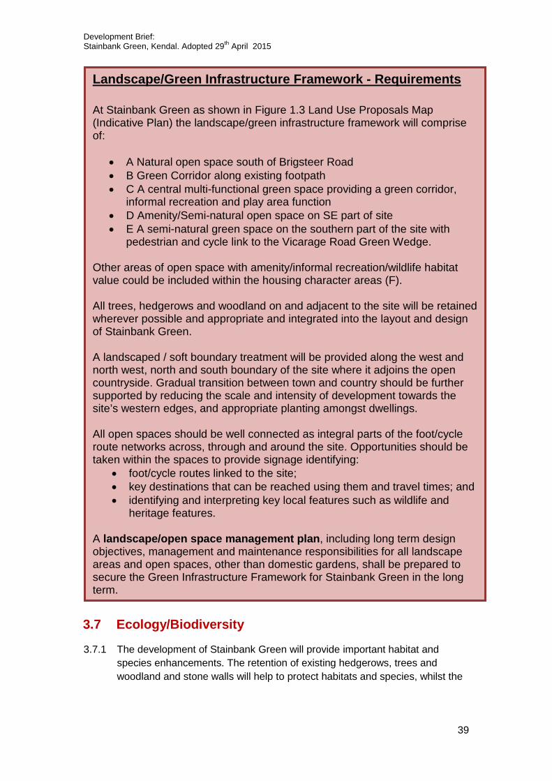
Landscape/Green Infrastructure Framework - Requirements
At Stainbank Green as shown in Figure 1.3 Land Use Proposals Map (Indicative Plan) the landscape/green infrastructure framework will comprise of:
• A Natural open space south of Brigsteer Road• B Green Corridor along existing footpath• C A central multi-functional green space providing a green corridor,
informal recreation and play area function• D Amenity/Semi-natural open space on SE part of site• E A semi-natural green space on the southern part of the site with
pedestrian and cycle link to the Vicarage Road Green Wedge.
Other areas of open space with amenity/informal recreation/wildlife habitat value could be included within the housing character areas (F).
All trees, hedgerows and woodland on and adjacent to the site will be retained wherever possible and appropriate and integrated into the layout and design of Stainbank Green.
A landscaped / soft boundary treatment will be provided along the west and north west, north and south boundary of the site where it adjoins the open countryside. Gradual transition between town and country should be further supported by reducing the scale and intensity of development towards the site’s western edges, and appropriate planting amongst dwellings.
All open spaces should be well connected as integral parts of the foot/cycle route networks across, through and around the site. Opportunities should be taken within the spaces to provide signage identifying:
• foot/cycle routes linked to the site;• key destinations that can be reached using them and travel times; and• identifying and interpreting key local features such as wildlife and
heritage features.
A landscape/open space management plan, including long term design objectives, management and maintenance responsibilities for all landscape areas and open spaces, other than domestic gardens, shall be prepared to secure the Green Infrastructure Framework for Stainbank Green in the long term.
39

Development Brief: Stainbank Green, Kendal. Adopted 29th April 2015
creation of new green spaces and corridors will result in enhancement and extension of existing habitat. In addition, the Sustainable Urban Drainage System Network may be designed to create benefits for wildlife and enhance the site’s ecological value.
3.7.2 Though not a protected species or County Wildlife site the NE part of the site includes pastureland of value for Meadow Saxifrage. As required by policy LA2.7 a detailed ecological survey needs to be carried out in order to identify the extent of its presence and determine what mitigation measures are required to ensure the development as a whole enhances this habitat. To satisfy the policy requirements it is essential the development as a whole enhances habitat. In determining the mitigation measures it will important to identify the role new open spaces on the site could play; there may be opportunity to transplant the species within the proposed semi natural green space on the south part of the site and/or adjacent to the site (land to the west and south).
3.7.3 The proposed green corridors and green spaces will help to provide a network of wildlife corridors which will help to provide a sense of continuity between Kendal and the countryside and allow species to migrate and reinforce habitats.
3.7.4 The Cumbria Biodiversity Evidence Base identified the potential presence of hare and badger (2012 records) amongst a range of key species. Detailed habitat and species surveys as appropriate will be required at the planning application stage. An assessment of all potential ecological impacts based on up to date baseline data will be used to inform any planning application and measures set out therein to protect and enhance habitats and species.
3.7.5 The landscape/open space management plan should consider biodiversity habitat restoration/establishment and replacement of habitat/species where appropriate based on the outcome of the surveys as part of any planning application.
3.8 Flood risk issues - considerations
3.8.1 The site lies within Flood Risk Zone 1 (tidal, main river and fluvial flooding). Due to the size of the site, a flood risk assessment will be prepared and submitted in support of any planning application. Surface water run-off after development must not exceed green field run off rates including an allowance for climate change. Surface water should not be disposed of via the public sewerage system. A sustainable urban drainage system (SuDs) and management plan will be implemented to manage the disposal of surface water and this will be integrated within the green infrastructure framework, working with the natural drainage and topography of the site to inform the choice of appropriate measures. SuDs should follow the CIRA principles given in the SuDs Manual c698. A maintenance manual will be required for
40
Development Brief: Stainbank Green, Kendal. Adopted 29th April 2015
surface water systems which require adoption and management where adoption and management scheme will be by a management company.
3.8.2 As mentioned in other sections of this document, opportunities should be taken in terms of the design and materials used to manage surface water disposal as effectively and sustainably as possible. For example in the use of permeable paving, imaginative planting and green roofs/walls, which, as part of the green infrastructure framework can have other benefits such as for health and well-being and wildlife and therefore contribute towards other objectives whilst also forming part of the drainage and surface water management approach.
3.9 Noise Impact
3.9.1 A noise impact assessment must be submitted as part of any future planning application. Potential noise impact from the A591 to the west will need to be considered. The outcome of the noise impact assessment will be used to determine the nature of any mitigation measures required.
3.10 Infrastructure Requirements
Utilities
3.10.1 In terms of services and utilities, there are no known constraints to the provision of gas, electricity, waste water or water supply on the site, although the precise means of supply and connection will be confirmed through discussions with the relevant utility bodies as part of any planning application.
3.10.2 Regarding access to the public sewer network there is a combined sewer network at Brigsteer Road. Developments must drain on a separate sewerage system, with only foul drainage connected into the foul sewerage network. United Utilities confirm their intention to install a water main through the site. Any potential developer will need to liaise with the relevant utility provider (United Utilities) to ensure this is taken into account at the detailed planning application stage.
Emergency services
3.10.3 Consideration needs to be given to emergency services infrastructure such as radio communication masts/equipment, fibre optic networks, CCTV and broadband internet coverage.
Community Infrastructure
Education
3.10.4 To assess the impact of the development on education, initially Cumbria County Council use a population model to estimate the pupil yield (the
41
Development Brief: Stainbank Green, Kendal. Adopted 29th April 2015
methodology of which is outlined in the County Council’s Planning Obligation Policy page 27 Figure 6). It is estimated that a development of 189 houses would yield 38 primary aged children and 27 secondary aged children. These figures are initial outline figures and more in depth assessments, using a dwelling led model (see page 27 figure 5 in the document referred to above) will need to be carried out when detailed housing plans as part of a planning application come forward. Based on these numbers the County Council will assess what space is available within local schools, including the catchment school and any other schools within a 2 mile safe walking distance. If no or limited places are available then a contribution will be sought to mitigate the effect of the development, where full costs are available for the mitigation this will be sought, otherwise a Department for Education multiplier will be used. Mitigations include expansions of schools through internal modifications or extensions, new schools or transporting pupils.
3.10.5 At this point in time, there is no existing spare capacity within the nearest primary schools to accommodate additional children. Cumbria County Council as the Local Education Authority will advise how to accommodate educational needs arising from the development and this will be determined through any planning application. The assessment of pupil yields from the site and school capacity will be updated each year in the annual review of the Infrastructure Delivery Plan. A more detailed assessment of estimated pupil yields from the site and the capacity in the local schools will be undertaken when a planning application is submitted.
3.10.6 For further details on education requirements, potential developers should contact Cumbria County Council Education Authority.
3.11 Design Principles
3.11.1 The design of this new development at Stainbank Green will be of a high quality that respects the site’s local context and character and neighbouring uses as well as the site’s wider countryside rural setting. It will be of a distinct character with a mix of design styles taking reference from local design characteristics and opportunities presented by existing natural and other features of the site to create individual character areas. A development of new dwellings that all look the same, is not imaginative and innovative, does not respond positively to its surroundings and local sensitivities, and/or that is ‘grey’ and monotonous in appearance (not in terms of colour) and a layout that is car dominated will not be acceptable.
3.11.2 Core Strategy policy CS8.10 states the siting, design, scale and materials of all development should be of a character that maintains or enhances the quality of the landscape or townscape and, where appropriate, should be in keeping with local vernacular tradition - this can still be achieved through a contemporary style using local materials. Designs that support and enhance local distinctiveness are encouraged. Development should protect and
42

Development Brief: Stainbank Green, Kendal. Adopted 29th April 2015
enhance key local views and features / characteristics of local importance and incorporate layouts that reinforce and reference local distinctiveness and character. Saved Policy S2 of the Local Plan 2007 contains a design code for South Lakeland that any new development must take account of.
3.11.3 Kendal is made up of different varieties of urban design. There is a need for the design and layout to respect nearby existing built form and landscape setting whilst also being creative, imaginative and innovative. For example, the development should seek to introduce an individual character and variety of style, avoiding replicating poor aspects of design, drawing on positive features of local design in the area and ensuring that particular characteristics of the site are responded to through design.
3.11.4 Close-range views of the site are afforded to properties adjacent the site. The layout and design of new development will need to be sensitive to existing levels of residential amenity with issues relating to the potential for visual impact and overlooking/privacy to be addressed through consideration of the design, scale and positioning (layout and orientation) of dwellings on these common boundaries, the introduction of landscaping/buffers where appropriate and separation distances between the existing properties and any new build. The orientation of buildings on slopes should be designed to minimise impact on residential amenity and careful attention must be given to the scale and massing of development in such locations in this context. It is essential each property has access to some form of private garden/communal space. This may comprise an element of shared space/facilities for practicalities such as drying washing and bin storage in addition to a private garden.
General Principles
3.11.5 The design of the Stainbank Green site should take full account of the character of the immediate and wider setting. It should take account of the design code in saved Policy S2 of the Local Plan. Key influences on character include history, geography, climate, topography, geology and building materials, as well as local culture. Kendal has a varied character. The predominant use of local stone or lime-based render and slate roofing provides a distinctive appearance to many buildings in the town. The design and layout of Stainbank Green will be informed by the following principles:
• Respond to the individual Townscape of Kendal and its surrounds inrespect of local characteristics such as building forms, materials,traditions, street patterns, roofscapes and spaces without creatingpastiche development styles. (See Saved Policy S2 of Local Plan).
• Places of Character should be created based upon appreciation ofthe site and surrounding area, and respond positively to its naturaland built context. Development will be integrated into its setting and
43

Development Brief: Stainbank Green, Kendal. Adopted 29th April 2015
respond to topography. The scale, form height, massing, grain of housing development will be related to that nearby to create an appropriate relationship with adjoining areas (built and rural), whilst maintaining variety within the built form. (See Saved Policy S2 of Local Plan).
• Take into account/refer to ‘Secured by Design’ principlesaccreditation.
• Locally relevant materials should be utilised. Building materials andcolours will be chosen for their high quality, reflection of site contextand ability to strengthen local distinctiveness. However, non-traditional/local material should not be ruled out. Materials should bedurable, robust and maintainable and wherever possible should besourced locally and sustainably. (See Saved Policy S2 of LocalPlan).
• Recognise, retain and make a feature of important views in thesite layout.
• Avoid uniform densities where appropriate across the developmentby providing variable densities to reflect character areas, topographyand the need for a transition between town and country.
• Housing design should be tenure blind i.e. it should not be possibleto determine the likely tenure of a property from its built appearanceand quality or materials used.
• Streets will be fronted by houses, avoiding blank and ensuringactive frontages.
• Make use of good quality materials in the public realm, including amix of hard and soft landscaping.
• Amenity – ensure a satisfactory level of privacy for existingdwellings and between dwellings whilst allowing for communityinteraction. Make use of screen walls, fences, ancillary out-buildingsand/or planting to moderate overlooking and maintain privacy. Usethe separation, placement and orientation of dwellings to one anotherto ensure reasonable levels of privacy between neighbouringproperties. Sloping sites – where the difference in levels may resultin unacceptable overlooking problems, consider use of appropriatescreening, window siting and orientation.
• Consider incorporating a range of building types and spaces toemphasise key locations within the layout and contribute to thecharacter and legibility of the development. For example positioningbuildings on the corners of streets.
• Orientation of buildings – Dwellings will be orientated anddesigned to ensure maximum solar gain and facilitate the maximumbenefit of solar panels (PV and thermal). Buildings on slopes should
44

Development Brief: Stainbank Green, Kendal. Adopted 29th April 2015
be designed to minimise impact on residential amenity and careful attention given to their scale and massing in this context.
• Design should add interest to and create variety in thedevelopment, taking opportunities to be imaginative and innovative inapproach.
• Boundary treatment defining individual curtilages should be clearand will be a mix of fencing, railing, hedgerow and walling to reflectthe local vernacular whilst allowing for community interaction.
• Settlement edges – development on the western and southernboundary of the site will create a positive relationship with theadjoining countryside, providing an appropriate transition betweenthe built up area and the adjoining landscape. Wherever possible,houses should be orientated so that they are outward facing. Trees,hedges and new landscape planting on the site edges should utilisenative species. The density, scale and intensity of developmenttowards the site’s western edge should be gradually reduced toensure a transition between town and countryside.
• Garden/communal spaces – It is essential each property hasaccess to some form of private garden/communal space. This maycomprise an element of shared space/facilities for practicalities suchas drying washing and bin storage in addition to a private garden.
• Bicycle Storage/Recycling Storage – the provision of bicyclestorage and recycling/bin storage should be convenient for residentsbut should not dominate or otherwise compromise the street scene.Communal facilities could be considered.
3.12 Sustainability Principles
3.12.1 Policy CS1.1 of the Core Strategy sets out the sustainable development principles that the new development at Stainbank Green site must conform to: Policy CS8.7 requires a sustainability statement to be included within the Design and Access Statement as part of any planning application, setting out how the development meets the principles set out in Policy CS1.1 as well as the National Planning Policy Framework.
3.13 Renewable Energy
3.13.1 In accordance with Policy CS8.7 the development should seek wherever possible to include renewable or low carbon options such as solar (photovoltaic or thermal), ground or air source heat pumps, micro/hydro turbines or biomass based on the technology most appropriate for the site. A district heating system could also be an option. The first consideration should be ensuring that the new homes are as energy efficient as possible, followed by steps to ensure that the residual energy demand is from
45

Development Brief: Stainbank Green, Kendal. Adopted 29th April 2015
renewable or low carbon sources wherever possible.
3.14 Sustainable Construction
3.14.1 The development of land at Stainbank Green has the potential to maximise energy efficiency and reduce the carbon footprint of homes through measures such as:
• Sustainable construction - The use of locally sourced materials andreclaimed/re-use of materials. (However, non-traditional/localmaterials should not be ruled out);
• Opportunities for passive solar gain – orientation of buildings tomaximize day lighting and passive solar gain;
• High levels of insulation, low energy fittings and other energyefficiency measures;
• Water conservation and recycling could be incorporated into newbuildings in ways that mean the water can be accessed for use e.g.in the toilets and garden areas (e.g. all new homes to be installedwith water butts);
• Street design and the layout of private space takes into accountaccess by waste/recycling collection vehicles and staff;
• Possible provision for communal recycling storage/collection (i.e.a single or small number of point(s) where everyone takes theirwaste/recyclables, composting etc. on site).
Green Roofs and Walls - roof gardens
3.14.2 The inclusion of green roofs/walls will be encouraged as a valid contribution to meeting a range of other requirements in a sustainable and efficient way. For example, green roofs, walls and roof gardens can assist in ensuring the gradual transition between urban and rural that is so important for this site and may also form part of the surface water management and drainage strategy. A range of green wall and roof approaches are available and can include very simple designs; advice and expertise on delivering these is also increasingly readily available. Roof gardens would also be supported where this approach can appropriately add interest and variety to the development, including in terms of variety and flexibility in the types of dwelling offered.
46

Development Brief: Stainbank Green, Kendal. Adopted 29th April 2015
3.15 Air quality
3.15.1 In accordance with policy CS10.2 an air quality assessment and travel plan will be required to accompany any planning application for the development of Stainbank Green. As set out in the Transport and Movement Framework, measures should be taken to maximise opportunities for people to use modes of transport other than the private car for their day-to-day needs. The wider green infrastructure framework, including appropriate planting and the inclusion of green roofs/walls, will also help to minimise negative effects on air quality by capturing additional pollutants.
3.16 Housing Character Areas – Specific Design and Layout Principles
3.16.1 Taking into account the local context and characteristics of different parts of the site, it is proposed that the site should be sub-divided into a series of character areas, the design of which will be based upon features and characteristics of those individual areas. These will relate to aspects such as streetscape, housing types, sizes and designs, scale of development, building height and enclosure, front treatments, topography and landscape, materials and architectural attributes. Key area-specific principles for each of the suggested housing character areas, relating to the landscaping/green infrastructure framework, design, layout and movement framework are proposed below:
Character Area 1 South of Brigsteer Road
1. Landscaping Good structural screening is provided by maturetrees/hedgerows on the north and south boundaries and these should beretained (except to provide road access). Additional planting within thischaracter area should be used to reinforce tree belts and should includetrees that are of a native species. A soft/landscaped boundary treatment isrequired along the western/northwest/northern boundary.
2. Brigsteer Road/ and Road/lane leading to Stainbank Green propertiesfrontage Development should respond positively and sensitively to therural characteristics of Brigsteer Road and the lane leading to StainbankGreen properties and this gateway location. Development should be setback from Brigsteer Road and the lane to Stainbank Green.
3. Scale Development on the NW / NE edge of this area will be of a scale andintensity that respects the rural character of the area and the gatewayentrance into Kendal. Development as a whole should respond to andrespect neighbouring properties to the east and north in terms of massing,height, scale and housing type, but should not necessarily be a pastiche ofthem.
4. Frontage/Boundary treatment onto natural open space
47

Development Brief: Stainbank Green, Kendal. Adopted 29th April 2015
5. A soft landscaped boundary treatment is required along the frontage withthe natural open space. Development should be sensitively designedpresenting a high quality frontage.
6. Pedestrian/Cycle links Pedestrian links will be provided onto the existingright of way adjoining the southern part of this ‘character area’ and to thewest, Brigsteer Road and the right of way to the east of the site and wherepossible cycle links also.
7. Road access A road access must be provided on the southern margin ofthis character area in order to connect the remainder of the site toBrigsteer Road. Its position should aim to minimise harm to the integrity ofthe green corridor/trees (Figure 1.3 identifies suggested preferredlocation).
8. Frontage onto green corridor to the south (B) Buildings will where possiblefront onto the green corridor to the south in order to maximise levels ofnatural surveillance and help integrate this part of the site with theremainder of Stainbank Green.
9. Open Space On the NE part of this character area will be the provision ofnatural green space (A) (non-public access).
Character Area 2 East of properties at Stainbank Green
1. Landscaping Good structural screening is provided by mature trees on thenorth boundary and will be retained (except to enable road access whereappropriate). Additional planting within this character area should includetrees that are of a native species.
2. Frontage onto green corridor to the north (B). Buildings will where possiblefront onto the green corridor to the north in order to maximise levels ofnatural surveillance and help integrate this part of the site with the housingto the north.
3. Scale Development on the west edge of this area will be of a lower scaleand intensity in order to respect the rural character of the area andscale/size of properties at Stainbank Green.
4. Pedestrian/Cycle links These will be provided to the rights of the wayadjoining the north and west boundary and the central multi-functionalgreen space to the south (C).
5. Frontage onto central multi-functional green space Buildings will wherepossible front onto the central multi-functional green space in order tomaximise levels of natural surveillance and help integrate this part of thesite with the remainder of Stainbank Green.
Character Area 3 West of Underwood and North West of Maple Drive 1. Landscaping Good structural screening is provided by mature trees and/or
woodland on the north and east boundary and will be retained. Additionalplanting within this character area should be used to reinforce tree belts
48

Development Brief: Stainbank Green, Kendal. Adopted 29th April 2015
and should include trees that are of a native species (on the NE edge in particular).
2. Frontage onto green corridor to the north. Buildings will where possiblefront onto the green corridor to the north in order to maximise levels ofnatural surveillance and help integrate this part of the site with the housingto the north.
3. Pedestrian/Cycle links These will be provided to the right of the wayadjoining the north boundary (green corridor) and the central multi-functional green space to the south. Pedestrian links and where possiblecycle links will be provided to the right of the way adjoining NE boundary ofthis character area.
4. Frontage onto central multi-functional green space to the south Buildingswill where possible front onto the central multi-functional green space inorder to maximise levels of natural surveillance and help integrate this partof the site with the remainder of Stainbank Green.
5. Open Space Open space could be provided within a central position withinthe character area helping to break up housing development and providinga community focal point; this should have an amenity/informal recreationvalue and could be connected to nearby open spaces through a greencorridor network.
Character Area 4 West of Cedar Grove/Aldercroft 1. Landscaping The hedgerow on the west boundary will be retained.
Woodland on the far SE part of the site will be retained. The hedgerow onthe southern boundary of this character area should wherever possible beretained with the main road located adjacent to it. The hedgerow is animportant feature providing a wildlife corridor and itself forms a greencorridor function. The tree with the TPO on the east part of this characterarea will be retained and could form part of an open space. Additionalplanting within this character area should be used to reinforce tree beltsand should include trees that are of a native species. The westernboundary should comprise a soft treatment with planting and trees andconsideration be given to the inclusion of additional planting outside thesite allocation boundary to the west.
2. Pedestrian/Cycle links These will be provided to the central multi-functionalgreen space to the north and links to Cedar Grove and the housing area(South Stainbank Green Character Area 5) and where possible theVicarage Road Green Wedge.
3. Frontage onto central multi-functional green space to the north Buildingswill where possible front onto the central multi-functional greenspace/green corridor in order to maximise levels of natural surveillance andhelp integrate this part of the site with the remainder of Stainbank Green.
4. Scale Development on the west edge of this area will be of a lower scaleand intensity in order to respect the rural character of the area.
49

Development Brief: Stainbank Green, Kendal. Adopted 29th April 2015
Development on the east part of this character area will take reference from neighbouring properties to the east in terms of massing, height, scale and housing type. These properties are a mix of one and two storey in size. To ensure a satisfactory level of privacy for existing dwellings and between dwellings whilst allowing for community interaction, use of screen walls, fences, ancillary out-buildings and/or planting to moderate overlooking and maintain privacy may be introduced as appropriate. It will be important to use the separation, placement and orientation of dwellings to one another to ensure reasonable levels of privacy between neighbouring properties.
5. Frontage onto amenity green space to SE Buildings will where possiblefront onto the amenity green space to the SE in order to maximise levels ofnatural surveillance.
6. Open Space This could be provided within a central position within thecharacter area focused on the tree with a TPO (F) helping to break uphousing development and providing a community focal point, this shouldhave an amenity/informal recreation value.
Character Area 5 South Stainbank Green 1. Landscaping The hedgerow on the north boundary of this character area
will be retained where possible with the main road positioned adjacent to it(north of it) with a footway/path along its southern side. The hedgerow isan important feature providing a wildlife corridor and itself forms a greencorridor function. The southern, eastern and western edges will respondsensitively to the adjoining area of semi-natural green space. The westernboundary should comprise a soft treatment with planting and trees andconsideration be given to the inclusion of additional planting outside thesite allocation boundary to the west.
2. Scale Development will need to carefully consider the residential amenityof the properties to the north on Aldercroft and Cedar Grove, the land ishigher and development will be particularly visible to these properties.Development of this area will be of a scale and massing that respects therural character of the area in terms of proximity to open countryside.
3. Pedestrian/Cycle links These will be provided to the housing area to thenorth and the semi natural green space to the south, and to the VicarageRoad Green Wedge.
4. Open Space An area of semi-natural greenspace will be provided to thesouth and south east of the character area.
50
Development Brief: Stainbank Green, Kendal. Adopted 29th April 2015
4. IMPLEMENTATION AND DELIVERY
4.1 Partners
Who will deliver the development?
4.1.1 Potential private housing developers and possibly Housing Associations will deliver the Stainbank Green site, in close liaison with South Lakeland District Council, Cumbria County Council and relevant third parties and statutory bodies.
4.2 Phasing/Timing
4.2.1 As the land is in multiple ownership it is possible the site will come forward in a number of stages given there is more than one developer interest at this point in time. Therefore there are likely to be a number of separate planning applications. It is important that with each stage of development the necessary amount of required infrastructure and open space is also provided in a timely way to ensure that individual applications are conducive to the comprehensive development of the site as a whole. It is crucial a holistic approach to delivery of the site allocation as a whole is adopted in order to ensure development is fully integrated and the required infrastructure can be fully realised in the most appropriate manner. The council considers the best way of ensuring this is achieved is for a single planning application to be submitted covering the whole site (outline stage); though aware this may not always be possible due to separate multiple ownership and developer interests. As part of the planning permission there will be key triggers requiring the construction of other integral elements of the scheme, with these principally relating to:
• Landscaping• Open space• Play space• Sustainable urban drainage system/masterplan• Pedestrian and cycle links• Affordable housing.
4.2.2 The precise timing of these elements will be agreed with the developer and controlled by condition/S106 agreement.
4.3 Planning Application
4.3.1 Any future planning application should be submitted in accordance with national planning application validation requirements and information set out in the Council’s Validation Checklist.
51

Development Brief: Stainbank Green, Kendal. Adopted 29th April 2015
4.3.2 In addition to standard national requirements, which consist of a completed planning application form, location plan and other plans and elevations where appropriate, any planning submission will need to be accompanied by a suite of additional supporting information. The nature of information and the level of detail required will be agreed with the Council, but will likely include:
• Design and Access Statement;• Planning Statement;• Transport Assessment and Travel Plan;• Sustainability Statement;• Land contamination assessment;• Tree and Hedgerow Survey and mitigation where appropriate;• Landscape and Visual Impact Assessment;• Flood Risk Assessment;• Plans and Drawings;• Habitats Survey and mitigation (Nature Conservation Assessment);• Archaeological Assessment;• Affordable Housing Statement;• Public Rights of Way Statement;• Air Quality Assessment;• Sustainable Urban Drainage Strategy and long term maintenance of
surface water drainage scheme/management and maintenance plan;• Statement of Community Involvement;• Noise Impact Assessment;• Foul Sewerage Assessment;• Planning Obligation Pro Forma Statement and S106 Heads of Terms• Landscape/Open Space Management Plan including long term
management and maintenance scheme
4.3.3 Where separate planning applications are submitted for phased development, rather than for the development of the allocation land as a whole, then legal planning obligations will be required to safeguard proportional financial contributions as a starting principle based on the developer contributions requirements in order to secure necessary infrastructure/open space/landscaping requirements across the whole allocation site. Proposals/applications submitted for part of the site must include provision for vehicular route / pedestrian /cycle access connections to adjoining part of the site; to enable the delivery of appropriate site access links across the site. The Council will expect applicants to use the Council’s pre-application process to agree a methodology necessary to deliver the infrastructure appropriate to their phase of the development and that needed for the comprehensive delivery of the site as a whole.
52

Development Brief: Stainbank Green, Kendal. Adopted 29th April 2015
4.3.4 A Section 106 Draft Heads of Terms should be agreed and submitted as part of any future planning application and this will confirm how developer contributions should be apportioned to each potential developer.
4.3.5 Pre-application consultation should be carried out in accordance with the guidelines set out in the Council’s Statement of Community Involvement (2006 and amended 2008). The scope of such consultation should be agreed with the Council.
4.4 Development Obligations
4.4.1 Listed in the table below are some of the likely infrastructure requirements which have been identified through consultation with various stakeholders for Stainbank Green (these are subject to further discussion as part of any planning application decision). South Lakeland District Council intends to introduce a Community Infrastructure Levy (CIL) in 2015. The nature of development obligations will be dependent on whether a CIL is in place or not. The table lists the type of infrastructure which currently it is considered could be funded through CIL if in place and through S106 contributions. On-site requirements will be funded through Section 106 contributions and/or S278 Agreements (Highways), whereas wider infrastructure benefits may be collected through the CIL. This is not an exhaustive list. The Council will expect applicants to agree a methodology necessary to deliver the infrastructure appropriate to their phase through the Council’s pre-application process.
Infrastructure Type On site or off-site
Details S106 or CIL
Landscaping including Tree Planting
On-site On site provision within and along edges of the sites where appropriate
On site construction cost?
S106 Open Space On-site New play area and
informal recreation space, green corridors, new amenity spaces and Natural and Semi-natural green space.
On site construction cost?
S106
Walking and Cycling On-site Financial contribution to new links between development and adjoining roads and Vicarage Drive Green Wedge.
S106
Education Off-site Financial CIL if in place,
53

Development Brief: Stainbank Green, Kendal. Adopted 29th April 2015
Infrastructure Type On site or off-site
Details S106 or CIL
contributions to provision of primary and secondary school places in Kendal
otherwise S106
Transport – Kendal Highways Package of Measures
Off-site Contributions to list of highways improvements measures identified in the Kendal Highways Improvement Study
CIL/Other funding – Local GrowthFund
Affordable Housing On-site 35 % affordable housing
S106
54
Development Brief: Stainbank Green, Kendal. Adopted 29th April 2015
USEFUL CONTACTS:
SLDC Development Plans Team – Officer Contacts:
Damian Law, Principal Development Plans Officer. Tel (01539) 793380, email [email protected]
SLDC Development Management – Officer Contact:
Fiona Clark, Principal Planning Officer. Tel (01539) 793348, email [email protected]
SLDC Housing Strategy – Officer Contact:
Tony Whittaker, Housing Strategy and Delivery Manager, Tel (01539) 793370, email [email protected]
SLDC – Parks and Recreation Team:
Tony Naylor, Green Spaces Officer, Tel (01539) 793166, email [email protected]
Deborah Wright, Principal Community Spaces Officer, Tel (01539) 793434, email [email protected]
Cumbria County Council – Highways:
Michael Hartley Acting Development Management Officer (South Cumbria), Tel (01229 408059) email [email protected]
Cumbria County Council Surface Water Drainage:
Doug Coyle, Highways & Transport Resilience Manager, Tel (01228) 221330 email [email protected]
Cumbria County Council Education:
Andy Smart, Children’s Services, Tel 07881264508. Email - [email protected]
55

Development Brief: Stainbank Green, Kendal. Adopted 29th April 2015
Relevant Utilities Providers Contacts:
United Utilities (waste water and water supply: Jenny Hope – Development Plan Liaison, United Utilities Group PLC Haweswater House, Lingley Mere Business Park, Lingley Green Avenue, Great Sankey, Warrington WA5 3LP Planning [email protected]
Electricity North West Ltd– Electricity: Mr Ian Povey, Network Design Manager, Frederick Road, Salford, M6 6QH 0161 604 1377 [email protected]
National Grid Electricity Transmission AMEC on behalf of National Grid Mr Julian Austin, Gables House, Kenilworth Road, Leamington Spa, Warwickshire, CV32 6JX. 01926 439078 [email protected]
National Grid Electricity Distribution AMEC on behalf of National Grid Mr Julian Austin, Gables House, Kenilworth Road, Leamington Spa, Warwickshire CV32 6JX 01926 439078 [email protected]
National Grid Gas Transmission AMEC on behalf of National Grid Mr Julian Austin, Gables House, Kenilworth Road, Leamington Spa, Warwickshire CV32 6JX 01926 439078 [email protected]
National Grid Gas Distribution National Grid Plant Protection Team, National Grid, Block 1, Floor 2, Brick Kiln Street, Hinckley, Leicestershire LE10 ONA [email protected]
56

Development Brief: Stainbank Green, Kendal. Adopted 29th April 2015
APPENDIX 1: Relevant Development Plan Policies
See website www.southlakeland.gov.uk
SOUTH LAKELAND LOCAL PLAN – CORE STRATEGY
CS1.1 – Sustainable Development Principles CS2 – Kendal Area Strategy CS6.3 – Provision of affordable housing CS6.6 – Making effective and efficient use of land and buildings CS7.3 – Education and skills CS8.1 – Green Infrastructure CS8.2 – Protection and enhancement of landscape and settlement character CS8.3a – Accessing open space, sport and recreation CS8.3b – Quantity of open space, sport and recreation CS8.4 – Biodiversity and geodiversity CS8.6 – Historic Environment CS8.7 – Sustainable construction, energy efficiency and renewable energy CS8.8 – Development and flood risk CS8.9 – Minerals and waste CS8.10 – Design CS9.1 – Social and community infrastructure CS9.2 – Developer Contributions CS10.1 – Accessing Services CS10.2 – Transport Impact of New Development
SOUTH LAKELAND LOCAL PLAN – LAND ALLOCATIONS DPD
LA1.3 – Housing Allocations LA2.7 – Stainbank Green
SOUTH LAKELAND LOCAL PLAN 2006, (incorporating adopted Local Plan Sept. 1997 & March 2006 Alterations).
C5 – External Lighting C19 – Sites of archaeological interest C24 – Watercourses and Coastal margins C30 – Solar Power L10 – Rights of Way Tr9 – Better Ways to School S2 – South Lakeland Design Code S3 – Landscaping S10 – Parking Provision in new development S12 – Crime and Design S18 – Trees close to buildings S19 – Percent for Art S26 – Sewage treatment and disposal S27 – Overhead lines S29 – Waste recycling facilities
57
Development Brief: Stainbank Green, Kendal. Adopted 29th April 2015
APPENDIX 2: South Lakeland District Council New Play Area Specification – Guidance Vision
The creation of cutting edge play areas and intriguing play and learning spaces. Spaces which make use of traditional and natural materials, using equipment to suit all ages, abilities and able or non-able bodied children and families.
Location To be sited in an open, welcoming location with good access links for the catchment area. Not to the rear of properties or with narrow access between properties, a minimum of 20metres where no wheeled sports are included and 30metres where this is the case from the edge of the property boundary (house itself) to the edge of the boundary of the equipped play area part of the open space.
To be separate from areas of major vehicle movements and accessible directly from pedestrian routes, linked, as far as possible, with other open spaces, footpath systems, amenity planting areas and other devices to provide the maximum separation from nearby residences.
To feel integrated into the development, more than a play space, an area for residents to meet, walk, make friends, and hold community events. An opportunity to develop a sense of community, rather than a no go area, or an area for a restricted sector of the community.
Accessibility Accessible by firm-surfaced footpaths suitable for pushchairs or wheel chairs; does not need to be a tarmac surface.
Play Equipment All play equipment and safety surface will conform to European Play Standards EN 1177 and En 1176. Play equipment will meet the needs of children aged 0-14 yrs, a variety of fixed play equipment for different age groups. A challenging and learning play environment in natural surroundings, making use of natural features, ground moulding, boulders etc. appropriately designed for a rural location. Grass mat safety surface is preferred
Where appropriate older teen facilities will be provided in a separate location.
Emphasis should be placed on the importance of design, challenge, accessibility, play value, the setting, and distance from houses
Ancillary Items
58

Development Brief: Stainbank Green, Kendal. Adopted 29th April 2015
Depending on the location of the play area, it is not always necessary to fence. Appropriate seating for adults and children, with litter bins and possibly a notice board. Size and type of play facility We recommend as a starting guide, the type and size of play facility should be based on Play England Play Space Classifications as appropriate; these are – Toddler/doorstep – small space near housing specifically designed for play; may or may not have some small items of equipment or other features for toddlers and seating for adults. Small play area – primarily aimed at under 8s with offering a variety of play experiences and/or seating. Near to housing. Large play area – aimed at 5 to 14 year old children with a larger range of features offering a wide range of play experiences, and space/design for ball games, wheeled sports. Offers seating and is near to housing. Neighbourhood play area – providing for all children including teenagers. Facilities as for large play area but with additional features offering challenge to older children; youth shelter type provision; and floodlit MUGA (multi-use game area) and/or wheeled sports facilities. Youth facilities – these are spaces aimed primarily at older children and teenagers (12+). They will range from youth shelters/meeting areas within local public open space to floodlit MUGAs, skateboard and BMX parks. Green spaces – parks, playing fields and other green spaces open to the public and available for play. Destination playgrounds – these are play spaces within key sites that are aimed at attracting family and similar groups for a longer visit. They will tend to be larger than neighbourhood sites, have car parking facilities, a greater variety of fixed equipment, and access to facilities such as cafes and public toilets. Other play spaces – outdoor play facilities and places where children can play that are not covered by the above, including home zones. The outcome of the play audit will be used to inform all decisions with regards the type and range of play opportunities and play equipment required for a play space. The play audit will commence in April and will be complete by July 2015, the council’s entire play provision will be reviewed. The audit will assess current levels of play provision for location, accessibility, play value, age range and condition, which will provide information on both shortfall and over provision with a prioritised action plan. Where there are known community groups, who have an interest in a local play area, they will be invited to take part in the audit. The play framework will provide a simple mechanism, which the council would like to ensure is used for all new play provision, to ensure all play areas are challenging, engaging, meet the correct age range, are maintainable and meet the budget available.
59

Development Brief: Stainbank Green, Kendal. Adopted 29th April 2015
Size Variable size, a minimum of 200 sqm where more than one play facility is present within the catchment area, or from 400m when only play item in catchment area. Consultation Where appropriate (depending upon location and houses sold) a public consultation event should be held to confirm challenges and equipment selected.
good use of firm paths to link equipment
Creative use of boulders, logs and earth can be used creatively too
60

Development Brief: Stainbank Green, Kendal. Adopted 29th April 2015
61