Embed Size (px)
Citation preview
Stage 1 Archaeological Assessment, Improvements to Balzer Creek, City of Kitchener _____________________________________________________________________________________________________________________
_____________________________________________________________________________________________________________________ July 2015 Archaeological Research Associates Ltd. PIF #P007-0694-2015
63
Janusas, S. 1987 An Analysis of the Historic Vegetation of the Regional Municipality of Waterloo.
Kitchener: Regional Municipality of Waterloo. 1988a An Archaeological Perspective of an Historical Overview of the Regional
Municipality of Waterloo. Kitchener: Regional Municipality of Waterloo. 1988b The Cultural Implication of Drainage in the Municipality of Waterloo. Kitchener:
Regional Municipality of Waterloo.
Johnston, C.M. 1964 The Valley of the Six Nations: A Collection of Documents on the Indian Lands of the
Grand River. Toronto: University of Toronto Press.
Karrow, P.F. and B.G. Warner 1990 The Geological and Biological Environment for Human Occupation in Southern Ontario.
In The Archaeology of Southern Ontario to A.D. 1650, edited by Chris J. Ellis and Neal Ferris, pp. 5–35. Occasional Publication of the London Chapter, OAS Number 5. London: Ontario Archaeological Society Inc.
Lajeunesse, E.J. 1960 The Windsor Border Region: Canada’s Southernmost Frontier. Toronto: The
Champlain Society.
Lennox, P.A. 1980 Report on the Archaeological Survey of the Proposed Hwy. 24 Hespeler Bypass,
Regional Municipality of Waterloo, Ontario (W.P. 67-72-00). PIF not available. Ministry of Transportation & Communications, Southwestern Region.
Lennox, P.A. and W.R. Fitzgerald. 1990 The Culture History and Archaeology of the Neutral Iroquoians. In The Archaeology of
Southern Ontario to A.D. 1650, edited by Chris J. Ellis and Neal Ferris, pp. 405–456. Occasional Publication of the London Chapter, OAS Number 5. London: Ontario Archaeological Society Inc.
Mason, R.J. 1981 Great Lakes Archaeology. New York: Academic Press.
McGill University 2001 The Canadian County Atlas Digital Project. Accessed online at:
http://digital.library.mcgill.ca/countyatlas/default.htm.
Métis Nation of Ontario (MNO) 2015 Culture & Heritage: Who are the Métis. Accessed online at:
http://www.metisnation.org/culture--heritage/who-are-the-metis.aspx.
Stage 1 Archaeological Assessment, Improvements to Balzer Creek, City of Kitchener _____________________________________________________________________________________________________________________
_____________________________________________________________________________________________________________________ July 2015 Archaeological Research Associates Ltd. PIF #P007-0694-2015
64
Ministry of Culture (MCL) 1997 Conserving a Future for Our Past: Archaeology, Land Use Planning & Development
in Ontario. An Educational Primer and Comprehensive Guide for Non-Specialists. Toronto: Ministry of Culture.
Ministry of Municipal Affairs and Housing (MMAH) 2014 Provincial Policy Statement, 2014. Toronto: Ministry of Municipal Affairs and Housing. Ministry of Natural Resources and Forestry (MNRF) 2014 Ontario’s Forest Regions. Accessed online at: http://www.ontario.ca/environment-and-
energy/forest-regions. Ministry of Tourism and Culture (MTC) 2011 Standards and Guidelines for Consultant Archaeologists. Toronto: Ministry of
Tourism and Culture. Ministry of Tourism, Culture and Sport (MTCS) 2015 Inquiry Concerning Sites within a One Kilometre Radius of the Project Area
(Ontario Archaeological Sites Database) and Past Archaeological Work within 50 m of the Project Area. Via PastPort, response provided by R. Von Bitter (May 19, 2015). MTCS.
Mississaugas of the New Credit First Nation (MNCFN) 2010 The History of the Mississaugas of the New Credit First Nation. Hagersville:
Mississaugas of the New Credit First Nation. Mulvany, C.P., G.M. Adam and C.B. Robinson 1885 History of Toronto and the County of York, Ontario, Volume 1. Toronto: C. Blackett
Robinson. Natural Resources Canada (NRC) 2002 Ontario Relief. Atlas of Canada, 6th Edition. Accessed online at:
http://geogratis.gc.ca/api/en/nrcan-rncan/ess-sst/632e8f7c-403a-57fe-849f-7cce3591d611.html.
2010 Historical Indian Treaties. Atlas of Canada, 6th Edition. Accessed online at: http://geogratis.gc.ca/api/en/nrcan-rncan/ess-sst/cb216b8f-8893-11e0-8ed0-6cf049291510.html.
Ontario Historical County Maps Project (OHCMP) 2015 Ontario Historical County Maps Project. Accessed online at:
http://maps.library.utoronto.ca/hgis/countymaps/maps.html.
Stage 1 Archaeological Assessment, Improvements to Balzer Creek, City of Kitchener _____________________________________________________________________________________________________________________
_____________________________________________________________________________________________________________________ July 2015 Archaeological Research Associates Ltd. PIF #P007-0694-2015
65
Peters, J.H. 1986 Transmission Line Planning and Archaeological Resources: A Model of
Archaeological Potential for Southwestern Ontario. In Archaeological Consulting in Ontario: Papers of the London Conference 1985, ed. W.A. Fox, pp. 19–27. Occasional Papers of the London Chapter, OAS Inc., No. 2. London: OAS.
Pihl, R.H. 1986 Site Potential Modeling in Archaeological Consulting. In Archaeological Consulting in
Ontario: Papers of the London Conference 1985, ed. W.A. Fox, pp. 29–40. Occasional Papers of the London Chapter, OAS Inc., No. 2. London: OAS.
Presant, E.W. and R.E. Wicklund 1971 The Soils of Waterloo County. Report No. 44 of the Ontario Soil Survey. Ottawa:
Research Branch, Canada Department of Agriculture. Ramsden, P.G. 1990 The Hurons: Archaeology and Culture History. In The Archaeology of Southern
Ontario to AD 1650, edited by Chris J. Ellis and Neal Ferris, pp. 361–384. Occasional Publication of the London Chapter, OAS Number 5. London: Ontario Archaeological Society Inc.
2015 Haudenosaunee (Iroquois). Accessed online at: http://www.thecanadianencyclopedia.ca/ en/article/iroquois/.
Ray, A.J. 2015 Hudson’s Bay Company. Accessed online at:
http://www.thecanadianencyclopedia.com/en/article/hudsons-bay-company. Schmalz, P.S. 1977 The History of the Saugeen Indians. Ottawa: Ontario Historical Society. Scrimgeour, P. 1990 Historical Outlines of Railways in Southwestern Ontario. Upper Canada Railway
Society Newsletter, July 1990. Six Nations Council 2010 Land Rights: A Global Solution for the Six Nations of the Grand River. Ohsweken:
Six Nations Lands & Resources Department. Smith, D.B. 1987 Sacred Feathers: The Reverend Peter Jones (Kahkewaquonaby) and the
Mississauga Indians. Toronto: University of Toronto Press. Smith, W.H. 1846 Smith’s Canadian Gazetteer: Comprising Statistical and General Information
Respecting all Parts of the Upper Province, or Canada West. Toronto: H. & W. Rowsell.
Stage 1 Archaeological Assessment, Improvements to Balzer Creek, City of Kitchener _____________________________________________________________________________________________________________________
_____________________________________________________________________________________________________________________ July 2015 Archaeological Research Associates Ltd. PIF #P007-0694-2015
66
Spence, M.W., R.H. Pihl and C. Murphy 1990 Cultural Complexes of the Early and Middle Woodland Periods. In The Archaeology of
Southern Ontario to A.D. 1650, edited by Chris J. Ellis and Neal Ferris, pp. 125–170. Occasional Publication of the London Chapter, OAS Number 5. London: Ontario Archaeological Society Inc.
Sprung, D.A. 1984 Pioneers of Waterloo County. Kitchener: Doon Pioneer Village. Surtees, R.J. 1994 Land Cessions, 1763–1830. In Aboriginal Ontario: Historical Perspectives on the
First Nations, edited by E.S. Rogers and D.B. Smith, pp. 92–121. Toronto: Dundurn Press.
University of Toronto 2009 Digital Aerial Photographs, Southern Ontario 1954 – West Index. Accessed online at:
http://maps.library.utoronto.ca/data/on/AP_1954/ indexwest.html. W.J. Gage and Co. 1886 Gage’s County Atlas. Toronto: W.J. Gage and Co. Warrick, G. 2000 The Precontact Iroquoian Occupation of Southern Ontario. Journal of World
Prehistory 14(4):415–456. 2005 Finding the Invisible Mississaugas of Davisville. Grand Actions 10(4):1–2. Williamson, R.F. 1990 The Early Iroquoian Period of Southern Ontario. In The Archaeology of Southern
Ontario to A.D. 1650, edited by Chris J. Ellis and Neal Ferris, pp. 291–320. Occasional Publications of the London Chapter, OAS Number 5. London: Ontario Archaeological Society Inc.
Williamson, R.F. (ed.) 2008 Toronto: A Short Illustrated History of its First 12,000 Years. Toronto: James Lorimer
& Company Ltd. Wright, J.V. 1972 Ontario Prehistory: An Eleven-Thousand-Year Archaeological Outline.
Archaeological Survey of Canada, National Museum of Man. Ottawa: National Museums of Canada.
Young, P.M., M.R. Horne, C.D. Varley, P.J. Racher and A.J. Clish 1995 A Biophysical Model for Prehistoric Archaeological Sites in Southern Ontario.
Toronto: Research and Development Branch, Ministry of Transportation.
Ecosystem Recovery Inc. City of Kitchener Balzer Creek Class Environmental Assessment and Preliminary Design October, 2015
Ecosystem Recovery Inc.Rpt-Balzer Class Ea Draft Final Oct 8- 2015
Appendix F Agency and Public Correspondence
ENGINEERING SERVICES
NOTICE OF STUDY COMMENCEMENT SCHEDULE ‘B’ CLASS ENVIRONMENTAL ASSESSMENT Balzer Creek from Old Country Drive to Schneider Creek
The Study The City of Kitchener through their consultant, Ecosystem Recovery Inc. has initiated a Class Environmental Assessment (EA) Study for the entirety of Balzer Creek which begins at Old Country Drive and flows beneath Homer Watson and Fallowfield Drive to the confluence with Schneider Creek. The study is being initiated in order to address erosion concerns and associated potential impacts to private and public infrastructure. The study will also explore opportunities to improve the watercourse, natural landscape, and potential trail connections in the area. The map below shows the location of the study area. The Process The City is conducting the EA study in accordance with Schedule ‘B’ of the Municipal Engineers Association (MEA) Municipal Class Environmental Assessment October 2000, as amended (in 2007 & 2011), in compliance with the Ontario Environmental Assessment Act. The Class EA process includes public and regulatory agency consultation, evaluation of project alternatives, an assessment of the impacts of the proposed improvements, and identification of measures to mitigate any adverse environmental impacts.
Upon completion of this study, the Project File documenting the Class EA process will be submitted to the Ministry of the Environment (MOE) and will be available for public review for a period of 30 calendar days. As part of this study, two Public Information Centres (PICs) are planned. The first PIC is tentatively scheduled for April of 2015. The PIC will present the project scope and objectives and provide an opportunity for initial public and government agency review and comment. Representatives from the City and the Consultant Team will be present at the PIC to answer questions and discuss the next steps in this study. Notification of the PIC will be provided` at the appropriate time by means of a similar advertisement in this newspaper. Comments Public consultation is vital to the Class EA process. The City wishes to ensure that anyone with an interest in this study has the opportunity to get involved and provide input before any decisions are made on a preferred concept for creek improvements. With the exception of personal information, all comments will become part of the public record.
To provide your comments or to request additional information concerning this project, please contact either of the following Project Team members:
Leah Walter, C.E.T. P. Eng. Wolfgang Wolter Project Manager, Stormwater Utility Senior Project Manager City of Kitchener Engineering Services 200 King Street West, P.O. Box 1118 Kitchener, Ontario N2G 4G7
Ecosystem Recovery Inc. 1023 Rife Road, Unit A Cambridge, Ontario N1R 5S3
Tel.: (519) 741-2200 ext. 7148 Tel.: (519) 621-1503 TTY: 1-866-969-9994 Fax: (519) 741-2230 Fax: (226) 240-1080 E-mail: [email protected] E-mail: [email protected]
This Notice was issued on October 31, 2014 and November 7, 2014
Legend
Project specific or additional stakeholders
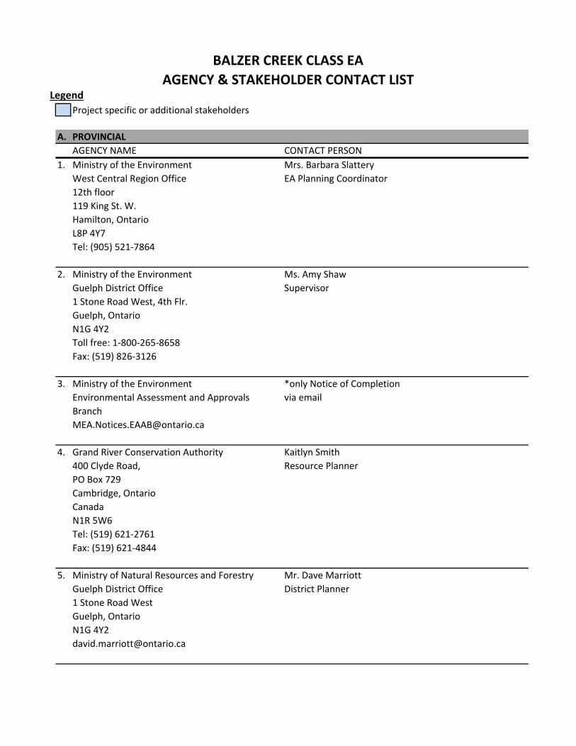
A. PROVINCIAL
AGENCY NAME CONTACT PERSON
1. Ministry of the Environment
West Central Region Office
12th floor
119 King St. W.
Hamilton, Ontario
L8P 4Y7
Tel: (905) 521‐7864
Mrs. Barbara Slattery
EA Planning Coordinator
2. Ministry of the Environment
Guelph District Office
1 Stone Road West, 4th Flr.
Guelph, Ontario
N1G 4Y2
Toll free: 1‐800‐265‐8658
Fax: (519) 826‐3126
Ms. Amy Shaw
Supervisor
3. Ministry of the Environment
Environmental Assessment and Approvals
*only Notice of Completion
via email
4. Grand River Conservation Authority
400 Clyde Road,
PO Box 729
Cambridge, Ontario
CanadaN1R 5W6
Tel: (519) 621‐2761
Fax: (519) 621‐4844
Kaitlyn Smith
Resource Planner
5. Ministry of Natural Resources and Forestry
Guelph District Office
1 Stone Road West
Guelph, Ontario
N1G 4Y2
Mr. Dave Marriott
District Planner
BALZER CREEK CLASS EA
AGENCY & STAKEHOLDER CONTACT LIST
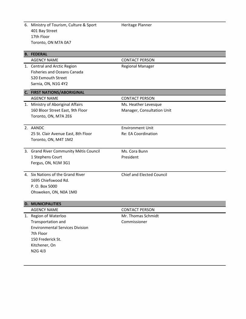
6. Ministry of Tourism, Culture & Sport
401 Bay Street
17th Floor
Toronto, ON M7A 0A7
Heritage Planner
B. FEDERAL
AGENCY NAME CONTACT PERSON
1. Central and Arctic Region
Fisheries and Oceans Canada
520 Exmouth Street
Sarnia, ON, N1G 4Y2
Regional Manager
C. FIRST NATIONS/ABORIGINAL
AGENCY NAME CONTACT PERSON
1. Ministry of Aboriginal Affairs
160 Bloor Street East, 9th Floor
Toronto, ON, M7A 2E6
Ms. Heather Levesque
Manager, Consultation Unit
2. AANDC25 St. Clair Avenue East, 8th Floor
Toronto, ON, M4T 1M2
Environment Unit
Re: EA Coordination
3. Grand River Community Métis Council
1 Stephens Court
Fergus, ON, N1M 3G1
Ms. Cora Bunn
President
4. Six Nations of the Grand River
1695 Chiefswood Rd.
P. O. Box 5000
Ohsweken, ON, N0A 1M0
Chief and Elected Council
D. MUNICIPALITIES
AGENCY NAME CONTACT PERSON
1. Region of Waterloo
Transportation and
Environmental Services Division
7th Floor
150 Frederick St.
Kitchener, On
N2G 4J3
Mr. Thomas Schmidt
Commissioner
2. Region of Waterloo
Planning, Housing and Community Services
Department Division
5th Floor
150 Frederick St.
Kitchener, On
N2G 4J3
Mr. Rob Horne
Commissioner
3. Region of Waterloo
Public Health Department
3rd Floor
99 Regina St. S.
Box 1633
Waterloo, Ontario
N2J 4V3
Dr Liana Nolan
Commissioner of Public
Health and Medical Officer of
Health
4. Region of Waterloo
Chief Administrative Office
1st Floor
150 Frederick St.
Kitchener, On
N2G 4J3
Mr. Mike Murray
Chief Administrative Officer
5. Region of Waterloo
150 Frederick Street, 7th floor
Kitchener, Ontario, N2G 4J3
Eric Hodgins
Manager Hydrogeology and
Source Water
E. UTILITIES
AGENCY NAME CONTACT PERSON
1. Hydro One Inc.
483 Bay Street, North Tower, 14th Floor
Toronto, Ontario
M5G 2P5
Tel: (416) 345‐6408
Fax: (416) 345‐5395
Mary Gordon
Director of Environment,
Health Safety and
Environment
2. Kitchener‐Wilmot Hydro
301 Victoria Street South
Kitchener, ON
N2G 4L2
Mrs. Sandy Ferneyhough
3. Utilities Operations Centre (Water)
200 King Street West
Kitchener ON
N2G 4G7
Mrs. Angela Mick
4. Utilities Operations Centre (Gas)
200 King Street West
Kitchener ON
N2G 4G7
Mr. Les Jones
5. Rogers Communications
Access Network Design/Planning
Tel: (519) 894‐8157
Fax: (519) 893‐6463
Greg Brown
6. Bell Canada
Access Network Provisioning
Tel: (519) 744‐0569
Fax: (519) 744‐9082
Dan Steffler
Manager
F. STAKEHOLDERS BY REQUEST
AGENCY NAME CONTACT PERSON
1 Office of the Mayor and council
Kitchener City Hall
200 King St. W.
Kitchener, Ontario, N2G 4G7
Coun. John Gazzola
Ward 3
2 Office of the Mayor and council
Kitchener City Hall
200 King St. W.
Kitchener, Ontario, N2G 4G7
Coun. Paul Singh
Ward 6
ENGINEERING SERVICES Leah Walter, P.Eng.
Design & Construction Project Manager 200 King St. W. – 9th Floor
Kitchener, ON N2G 4G7 Phone: (519) 741-2200 ext. 7815
TTY: 1 866 969-9994 [email protected]
www.kitchener.ca
October 28, 2014 Dear Resident/Occupant/Property Owner: Re: Balzer Creek EA A notice of Commencement has been placed in publication to advise the public that a Class Environmental Assessment Study, Schedule ‘B’ is being carried out by the City of Kitchener to address erosion and slope stability issues identified in Blazer creek between Old Country Drive to downstream of Fallowfield Drive. A copy of the ad can be viewed on the city’s website.
During the initial stages of the study, (planned to occur in the months of November and December 2014), the City and the Consulting team will need to collect information regarding the study area through a series of site visits. The type of information to be collected will consist of the following:
Vegetative Communities
Terrestrial Communities
Aquatic species
Wetland areas
Erosion sites
Water levels and hydraulic data
Creek characteristics, banks, floodplain, channel features
Infrastructure (storm and sanitary)
Other relevant details
Consulting staff will also be undertaking a topographic survey of the channel and relevant areas to develop a geometric representation of the site for use in developing alternatives in the EA process.
In addition, a geotechnical firm (LVM) which forms part of the consulting team will be visiting the site at several locations along the reach to collect soil data. The data will be used to characterize soil conditions and help to develop slope stability assessments as well as to inform development of the alternatives in the EA process.
City and consulting staff should not interfere with your regular activities, however they will identify themselves to you if you have any questions.
Please feel free to contact the City’s project manager, Leah Walter if you have any questions. Leah Walter, C.E.T. P.Eng. Project Manager, Stormwater Utility City of Kitchener Phone: (519) 741-2200 ext. 7148 Email: [email protected]
City
of K
itche
ner
Pub
lic In
form
atio
n C
entre
Apr
il 28
, 201
5
City
of K
itche
ner
Pub
lic In
form
atio
n C
entre
Stud
y O
bjec
tives
and
C
lass
Env
ironm
enta
l Ass
essm
ent P
roce
ss
Iden
tify
Prob
lem
or
Opp
ortu
nity
Iden
tify
Pote
ntia
l So
lutio
ns
Publ
ic
Con
sulta
tion
Phas
es 1
& 2
of t
he C
lass
EA
Pro
cess
Inve
ntor
y N
atur
al, S
ocia
l, Ec
onom
ic
Envi
ronm
ent
Iden
tify
Impa
cts
of
Alte
rnat
ives
Eval
uate
A
ltern
ativ
es
and
Iden
tify
a So
lutio
n
Sele
ct
Pref
erre
d So
lutio
n
Prob
lem
Sta
tem
ent:
The
purp
ose
of th
e st
udy
is to
add
ress
ero
sion
co
nce
rns
and
th
e cr
eek’
s m
igra
tio
n o
ver
a tr
un
k sa
nita
ry s
ewer
, whi
ch h
as o
ccur
red
over
tim
e.
Th
is s
tud
y is
bei
ng
co
mp
lete
d u
nd
er S
ched
ule
“B
” of
the
Mun
icip
al C
lass
Env
ironm
enta
l Ass
essm
ent
proc
ess.
Thi
s po
rtio
n of
the
stud
y sp
ecifi
cally
ad
dres
ses
Phas
es 1
& 2
.
YOU
AR
E H
ERE
Publ
ic
Con
sulta
tion
Stud
y A
rea
City
of K
itche
ner
Pub
lic In
form
atio
n C
entre
Prim
ary
Dis
cipl
ines
Invo
lved
in s
ite c
hara
cter
izat
ion
City
of K
itche
ner
Pub
lic In
form
atio
n C
entre
Engi
neer
ing
•Hyd
rolo
gic
data
revi
ewed
and
ass
esse
d fo
r app
licat
ion
to c
urre
nt m
odel
s•H
ydra
ulic
Mod
el c
onst
ruct
ed u
sing
som
e ex
istin
g m
odel
info
rmat
ion
•Flo
od a
nd e
rosi
on a
sses
smen
t com
plet
ed
Geo
mor
phol
ogy
•Top
ogra
phic
sur
vey
of B
alze
r Cre
ek•F
ield
inve
stig
atio
ns•A
rea
of c
once
rn in
vent
ory
•Dat
a an
alys
es
Ecol
ogy
•Veg
etat
ion
com
mun
ity m
appi
ng, f
all p
lant
s, in
cide
ntal
bird
s an
d w
ildlif
e, fi
sh a
nd b
enth
ic in
verte
brat
es s
ampl
ing,
win
ter d
eer
surv
ey•W
etla
nds
wer
e fla
gged
in th
e fie
ld a
nd re
view
ed w
ith G
RC
A an
d su
rvey
ed•A
quat
ic a
sses
smen
t
Geo
tech
nica
l≠
Mos
tly fo
cuse
d on
Rea
ch 2
and
3≠
Loca
ted
with
in w
hat i
s kn
own
as W
ater
loo
Hill
s / M
orai
ne -
Com
pris
ed o
f san
dy h
ills,
fine
gra
ined
till
≠A
tota
l of 7
bor
ehol
es a
nd 3
han
dhol
es w
ere
adva
nced
to d
eter
min
e th
e so
il co
mpo
sitio
n an
d as
sess
slo
pe s
tabi
lity
alon
g th
e re
ache
s
Exis
ting
Con
ditio
ns a
nd Is
sues
s ––
Rea
ch 1
Rea
ch 1
–Is
sues
•Se
vent
een
(17)
are
as o
f con
cern
: fis
h pa
ssag
e, e
rosi
on, o
utfa
lls•
Lack
of r
ipar
ian
zone
aro
und
the
cree
k lim
its h
abita
t pot
entia
l•
Ban
k er
osio
n an
d st
orm
wat
er ru
noff
cont
ribut
es s
edim
ent t
o cr
eek
•Po
or a
quat
ic h
abita
t
Exam
ple
of b
ank
eros
ion
Dow
nstr
eam
face
of c
ulve
rt
unde
r Cou
ntry
Hill
Driv
e.
Gab
ions
are
faili
ng.
Pede
stria
n pa
thw
ay c
onne
ctio
n un
der H
omer
Wat
son
Bou
leva
rd,
faili
ng g
abio
n be
d an
d ba
nks
Nar
row
cha
nnel
with
littl
e rip
aria
n ve
geta
tion
Exis
ting
pede
stria
n br
idge
ove
r Bal
zer
Cre
ek; a
butm
ent c
ompr
omis
ed
Stor
m w
ater
out
fall
–so
urce
of
Bal
zer C
reek
6541 2 3
City
of K
itche
ner
Pub
lic In
form
atio
n C
entre
Cre
ek; a
butm
ent c
ompr
omis
ed
N
23
4
6
1
5
Pote
ntia
l Alte
rnat
ives
–R
each
1A
ltern
ativ
e #1
: Do
Not
hing
•C
reek
will
con
tinue
to e
rode
, fai
lure
of P
VC
Cre
ek w
ill c
ontin
ue to
ero
de, f
ailu
re o
f PVC
pi
pes/
outfa
lls is
exp
ecte
d, p
edes
tria
n br
idge
will
be
pipe
s/ou
tfalls
is e
xpec
ted,
ped
estr
ian
brid
ge w
ill b
e fu
rthe
r com
prom
ised
, sed
imen
tatio
n w
ill c
ontin
ue.
Alte
rnat
ive
#2: E
rosi
on S
pot I
mpr
ovem
ents
•M
itiga
te e
rosi
on a
reas
whe
re th
ere
is fu
ture
pot
entia
l M
itiga
te e
rosi
on a
reas
whe
re th
ere
risk
to in
fras
truc
ture
or p
rope
rty
•R
epai
r fai
ling
gabi
on b
aske
ts a
nd in
stal
l out
fall
Rep
air f
ailin
miti
gatio
n
Alte
rnat
ive
#3: 3:
Cha
nnel
Impr
ovem
ents
•Fl
ow e
nerg
y m
anag
emen
t, in
clud
es in
stal
latio
n of
Fl
ow e
nerg
y m
anag
emen
t, in
clud
es in
stal
latio
n of
in
stre
am s
truc
ture
s to
redu
ce e
nerg
y gr
ade,
thus
in
stre
am s
truc
ture
s to
redu
ce e
nerg
y gr
ade,
thus
redu
cing
impa
ct w
ithin
Rea
ch 1
and
to R
each
2•
Inst
all P
lung
e Po
ol D
/S o
f Old
Cou
ntry
Dr.
and
Cou
ntry
In
stal
l Pl
Hill
Dr.
•M
itiga
te e
rosi
on a
reas
and
inst
all o
utfa
ll m
itiga
tion
City
of K
itche
ner
Pub
lic In
form
atio
n C
entre
POTE
NTI
AL P
LUN
GE
POO
L
POTE
NTI
AL P
LUN
GE
POO
L
Feat
ures
to b
e in
clud
ed a
s pa
rt o
f im
plem
entin
g A
ltern
ativ
es 2
and
3•
Bio
engi
neer
ed tr
eatm
ents
on
bank
s an
d sl
opes
, w
here
pos
sibl
e •
Inst
alla
tion
of s
torm
sew
er o
utfa
ll di
scha
rge
ener
gy
diss
ipat
ion
stru
ctur
es (p
ools
with
rock
)•
Type
2 m
ulti-
use
path
way
whe
re g
ap e
xist
s be
twee
n C
ount
ry H
ills
Driv
e an
d H
omer
Wat
son
Bou
leva
rd (f
or
all A
ltern
ativ
es).
POTE
NTI
AL P
LUN
GE
POO
L
Bio
engi
neer
ing
Out
fall
Miti
gatio
nIn
stre
am P
lung
e Po
ols
Rea
ch 2
–Is
sues
•Se
ven
(7) a
reas
of c
once
rn id
entif
ied
•C
reek
is in
clo
se p
roxi
mity
to s
ever
al re
side
ntia
l pro
pert
ies
•M
anho
le is
in c
reek
; cre
ek is
1.4
m o
ver s
anita
ry s
ewer
•C
reek
lose
s fo
rm in
cen
tral
por
tion
of re
ach,
with
pot
entia
l im
pact
s to
aqu
atic
ha
bita
t and
sed
imen
tatio
n •
Ong
oing
cre
ek d
evel
opm
ent a
nd fu
ture
kni
ckpo
intm
igra
tion
pres
ent a
futu
re
risk
to e
xist
ing
sani
tary
sew
er li
ne a
nd m
anho
le•
Act
ive
cree
k m
igra
tion
cont
ribut
es fi
ne s
edim
ent t
o cr
eek
Exis
ting
Con
ditio
ns a
nd Is
sues
s ––
Rea
ch 2
23
4
6
1
5
Cre
ek d
iver
ges
into
num
erou
s sm
all
chan
nels
and
lose
s fo
rm
Act
ive
bank
ero
sion
and
se
dim
enta
tion
Trip
le c
ulve
rt c
ross
ing
unde
r Fa
llow
field
Driv
e
Sani
tary
man
hole
in m
iddl
e of
cre
ek
Cre
ek a
djac
ent t
o th
e re
ar y
ards
of
sev
eral
pro
pert
ies
alon
g B
risba
ne C
ourt
Eros
ion
exte
ndin
g to
top
of b
ank
6541 2 3
City
of K
itche
ner
Pub
lic In
form
atio
n C
entre
Pote
ntia
l Alte
rnat
ives
–R
each
2A
ltern
ativ
e #1
: Do
Not
hing
•R
each
wou
ld c
ontin
ue to
deg
rade
and
pos
e R
each
wou
ld c
ontin
ue to
deg
rade
and
po
ade
and
poim
pedi
men
t to
upst
ream
fish
mig
ratio
n •
Sani
tary
sys
tem
wou
ld b
e at
risk
in th
e fu
ture
•Fu
ture
pot
entia
l los
s of
priv
ate
prop
erty
Alte
rnat
ive
#2: R
eloc
ate
Sani
tary
Sys
tem
•In
stal
l an
addi
tiona
l tw
o m
anho
les
and
repl
ace
two
Inst
all a
n ad
ditio
nal t
wo
man
hole
s an
d re
plac
e tw
o ex
istin
g m
anho
les
to m
ove
sani
tary
pip
e aw
ay fr
om
exis
ting
mch
anne
l•
Stab
ilize
cha
nnel
to re
duce
risk
of r
ere-e-oc
curr
ence
•C
ontin
ued
risk
to p
rivat
e pr
oper
ty
Alte
rnat
ive
#3: C
hann
el R
eR
e-e-al
ignm
ent
•R
eR
eR
-e-al
ign
chan
nel a
way
from
priv
ate
prop
erty
and
RR
eelig
n ch
anne
l ala
sani
tary
sys
tem
•R
ecre
ate
chan
nel f
orm
and
func
tion,
sta
biliz
e R
ecre
ate
chan
nel f
orm
and
func
tion,
stab
ilize
ch
anne
l, pr
ovid
e er
osio
n co
ntro
l whe
re n
eces
sary
Feat
ures
to b
e in
clud
ed a
s pa
rt o
f im
plem
entin
g A
ltern
ativ
es 2
and
3•
Land
scap
e re
stor
atio
n us
ing
nativ
e pl
ant/t
ree
spec
ies
•U
se o
f Nat
ural
Cha
nnel
Des
ign
prin
cipl
es fo
r any
ch
anne
l rel
ocat
ion
•M
itiga
tion
of s
torm
sew
er o
utfa
lls (e
rosi
on c
ontr
ol)
•Ty
pe 2
mul
ti-us
e pa
thw
ay w
here
gap
exi
sts
betw
een
Hom
er W
atso
n B
oule
vard
and
Fal
low
field
Driv
e (w
ould
als
o se
rve
as m
aint
enan
ce a
cces
s to
th
e sa
nita
ry s
ewer
infr
astr
uctu
re).
City
of K
itche
ner
Pub
lic In
form
atio
n C
entre
the
sani
tary
sew
er i
POTE
NTI
AL S
ANIT
ARY
SEW
ER L
OC
ATIO
N
Bio
engi
neer
ing
Man
hole
Pro
tect
ion
Exis
ting
Con
ditio
ns a
nd Is
sues
s ––
Rea
ch 3
Rea
ch 3
–Is
sues
•Fi
ve (5
) are
as o
f con
cern
iden
tifie
d
•Er
osio
n of
a s
teep
val
ley
wal
l is
occu
rrin
g ad
jace
nt to
a p
lann
ed
deve
lopm
ent a
rea,
pre
sent
ing
a po
tent
ial e
rosi
on ri
sk h
azar
d
•Po
tent
ial f
ish
pass
age
conc
ern
at F
allo
wfie
ldD
rive
•A
ccum
ulat
ion
of w
oody
deb
ris in
the
chan
nel m
ay re
stric
t flo
od c
apac
ity o
f th
e ch
anne
l and
cre
ate
scou
r/ero
sion
are
as
Slop
e er
osio
n le
d to
larg
e tr
ee fa
ll ac
ross
the
cree
k
Erod
ed b
ank
and
stee
p va
lley
wal
l
Larg
e w
oody
deb
ris in
the
chan
nel a
nd
on fl
oodp
lain
nea
r out
let t
o Sc
hnei
der
Cre
ek
Slop
e er
osio
n, le
adin
g to
inci
pien
t tr
ee fa
ll
Cre
ek is
wel
l con
nect
ed to
its
flood
plai
n
Fore
sted
ripa
rian
zone
dow
nstr
eam
of
Fal
low
field
Driv
e
6541 2 3
City
of K
itche
ner
Pub
lic In
form
atio
n C
entre
Cre
ek is
wel
l con
nect
ed to
its
2
3
4
6
15
Pote
ntia
l Alte
rnat
ives
–R
each
3A
ltern
ativ
e #1
: Do
Not
hing
•R
each
wou
ld c
ontin
ue to
evo
lve
•M
igra
tion
tow
ard/
alon
g va
lley
wal
l wou
ld c
ontin
ue
Alte
rnat
ive
#2: S
tabi
lize
Cha
nnel
•Pr
ovid
e to
e pr
otec
tion
to s
outh
val
ley
wal
l•
Rem
ove
larg
e w
oody
deb
ris ja
m if
it p
oses
risk
to
Rem
ove
larg
e w
oody
deb
ris ja
m if
it p
oses
risk
tova
lley
eros
ion
or C
N b
ridge
in S
chne
ider
Cre
ek•
Rem
ove
fish
pass
age
barr
ier a
t at tF
allo
wfie
ldddD
rive
Rem
ove
culv
ert
Alte
rnat
ive
#3: R
eR
e-e-al
ign
Cha
nnel
•
Rem
ove
thre
at o
f fur
ther
ero
sion
and
toe
inst
abili
ty
Rem
ove
thre
at o
f fur
the
from
sou
th v
alle
y w
all
•C
reat
e ne
w c
hann
el u
sing
nat
ural
cha
nnel
des
ign
•St
abili
ze s
lope
alo
ng s
outh
val
ley
wal
l
Feat
ures
to b
e in
clud
ed a
s pa
rt o
f im
plem
entin
g A
ltern
ativ
es 2
and
3•
Land
scap
e re
stor
atio
n us
ing
nativ
e pl
ant/t
ree
spec
ies
•B
ioen
gine
ered
trea
tmen
ts o
n ba
nks
and
slop
e w
here
po
ssib
le•
Use
of n
atur
al m
ater
ials
suc
h as
logs
, woo
dy
mat
eria
ls a
nd ro
und
ston
e.
City
of K
itche
ner
Pub
lic In
form
atio
n C
entre
Woo
dy D
ebris
Toe
Prot
ectio
n
Bio
engi
neer
ing
Opp
ortu
nitie
s an
d C
onst
rain
ts
City
of K
itche
ner
Pub
lic In
form
atio
n C
entre
Alte
rnat
ives
Opp
ortu
nitie
sC
onst
rain
tsR
each
1A
ltern
ativ
e #1
: Do
Not
hing
•N
oca
pita
l cos
ts re
quire
d•
Issu
es in
Rea
ch 1
are
not
sev
ere
and
do n
ot im
pose
sig
nific
ant r
isk
•Lo
caliz
ed e
rosi
on is
sues
may
con
tinue
to d
egra
de, e
vent
ually
requ
iring
repa
irs to
pr
otec
t pro
perty
and
infra
stru
ctur
eA
ltern
ativ
e #2
: Ero
sion
Spo
t A
ltern
ativ
e #2
:EIm
prov
emen
ts•
Cos
t-effe
ctiv
e so
lutio
n to
the
loca
lized
issu
es in
Rea
ch 1
•M
itiga
teso
me
flow
ene
rgy
•E
rosi
on s
pot i
mpr
ovem
ents
may
not s
igni
fican
tlyco
ntrib
ute
to th
e im
prov
emen
t of
dow
nstre
am re
ache
s (fl
ow e
nerg
y m
itiga
tion,
etc
.)
Alte
rnat
ive
#3: C
hann
el
Alte
rnat
ive
#3:C
Impr
ovem
ents
•S
pace
and
con
stru
ctio
n ac
cess
is a
vaila
ble
to c
ompl
ete
the
impr
ovem
ents
•Im
prov
emen
tsco
mpl
eted
in R
each
1 w
ould
ben
efit
dow
nstre
am re
ache
s an
d th
e cr
eek
syst
em a
s a
who
le in
clud
ing
aqua
tic h
abita
t
•H
ighe
r cos
tsw
ould
be
requ
ired
to c
ompl
ete
the
chan
nel i
mpr
ovem
ents
com
pare
d to
er
osio
n sp
ot im
prov
emen
ts
Rea
ch 2
Alte
rnat
ive
#1: D
o N
othi
ng•
No
capi
tal c
osts
requ
ired
•S
ever
e er
osio
nat
the
sani
tary
sew
er in
curs
hig
h ris
k of
dam
age
•P
oten
tially
hig
h fu
ture
cos
ts if
dam
age
to th
e cr
eek
or s
ewer
wer
e to
con
tinue
to
wor
sen
•C
urre
ntly
ther
e is
no
mai
nten
ance
acc
ess
to s
uppo
rt sa
nita
ry s
ewer
infra
stru
ctur
e•
Terr
estri
al/w
etla
nd/a
quat
ic e
nviro
nmen
t im
pact
of r
eloc
atin
g sa
nita
ry s
yste
mA
ltern
ativ
e #2
: Rel
ocat
e Sa
nita
ry
Alte
rnat
ivSy
stem
•M
ovin
g th
e sa
nita
ry s
ewer
aw
ay fr
om th
e cr
eek
prov
ides
effe
ctiv
e m
itiga
tion
of e
rosi
on ri
sk•
Rel
ocat
ion
of th
e sa
nita
ry s
ewer
is e
xpec
ted
to c
ostm
ore
than
real
ignm
ent o
f the
cre
ek•
No
impr
ovem
ent t
o aq
uatic
hab
itat o
r lon
g te
rm c
hann
el s
tabi
lity
Alte
rnat
ive
#3: C
hann
el R
eR
e-e-al
ignm
ent
•Th
ere
is s
igni
fican
t ava
ilabl
e sp
ace
adja
cent
to th
e cr
eek
to c
ompl
ete
the
real
ignm
ent
•P
rovi
des
an e
ffect
ive
miti
gatio
n of
risk
to th
e sa
nita
ry s
ewer
and
adj
acen
t re
side
nces
•C
ost-e
ffect
ive
com
pare
d to
san
itary
sew
er re
loca
tion
•P
rovi
des
an o
ppor
tuni
ty to
enh
ance
cre
ek d
ynam
ics,
aqu
atic
hab
itat,
and
terr
estri
al h
abita
t
•P
rese
nce
of a
But
tern
ut tr
ee a
djac
ent t
o th
e cr
eek
may
lim
it re
alig
nmen
t opt
ions
•P
rese
nce
of w
etla
nds/
coni
fero
us fo
rest
nee
d to
be
cons
ider
ed in
real
ignm
ent d
esig
n
Rea
ch 3
Alte
rnat
ive
#1: D
o N
othi
ng•
No
capi
tal c
osts
requ
ired
•P
rivat
e pr
oper
ty w
ould
be
at ri
sk fr
om v
alle
y w
all e
rosi
on if
con
ditio
ns c
ontin
ue to
de
grad
e
Alte
rnat
ive
#2: S
tabi
lize
Cha
nnel
•Lo
cals
tabi
lizat
ion
will
min
imiz
e im
pact
to th
e cr
eek,
allo
win
g na
tura
l dyn
amic
s to
con
tinue
•R
educ
e ris
k to
priv
ate
prop
erty
by
stab
ilizi
ng to
e an
d cr
eek
•Th
e cr
eek
will
con
tinue
to b
e in
con
tact
with
the
valle
y w
all,
with
pot
entia
l ris
k of
on
goin
g er
osio
n an
d va
lley
wal
l ins
tabi
lity
loca
lly o
r fur
ther
dow
n-va
lley
Alte
rnat
ive
#3: R
eR
e-e-al
ign
Cha
nnel
•
Pro
vide
s th
em
ost e
ffect
ive
solu
tion
to m
itiga
te e
rosi
on ri
sk
•Th
ere
is s
igni
fican
t ava
ilabl
e sp
ace
adja
cent
to th
e cr
eek
to c
ompl
ete
the
real
ignm
ent
•A
high
er a
mou
nt o
f dis
turb
ance
to th
e su
rrou
ndin
g w
oode
d ar
ea m
ay b
e re
quire
d to
co
mpl
ete
the
real
ignm
ent c
ompa
red
to A
ltern
ativ
e 2
•H
ighe
r cos
t tha
n A
ltern
ativ
e 2
Exam
ples
of R
esto
ratio
n D
etai
ls
City
of K
itche
ner
Pub
lic In
form
atio
n C
entre
Nat
ural
Cha
nnel
Des
ignggggg
Live
Crib
Wal
l
POO
L
POIN
T B
AR
POI
POI
POO
LR
IFFL
ER
IR
IPO
INT
BA
R
Arm
ours
tonee
Prot
ecte
d M
anho
le
Woo
dy D
ebris
yyyyyy
Out
fall
and
Inst
ream
Plu
nge
Pool
ggggK
itche
ner M
ultitt-tti-
Use
Pat
hway
Mas
ter P
lan
Bio
engi
neer
ing
gggggggggggggg

Eval
uatio
n C
riter
ia
City
of K
itche
ner
Pub
lic In
form
atio
n C
entre
Crit
eria
Tech
nica
l Crit
eria
Envi
ronm
enta
l Crit
eria
Ero
sion
Impa
ct to
Wet
land
Floo
ding
Impa
ct to
Ter
rest
rial H
abita
t W
ater
Qua
lity
Impa
ct to
Aqu
atic
Hab
itat
Geo
mor
phol
ogy
Impa
ct to
Wild
life
Con
stru
ctab
ility
Impa
ct to
Veg
etat
ion
Acc
ess
to in
frast
ruct
ure
Impa
cts
to o
ther
reac
hes
Pro
tect
ion
of In
frast
ruct
ure
App
rova
bilit
yEc
onom
ic C
riter
iaSo
cial
Crit
eria
Con
stru
ctio
n C
osts
Impa
ct to
Priv
ate
Pro
perty
Mai
nten
ance
Cos
tsIm
pact
to P
ublic
Saf
ety
Con
stru
ctio
n Im
pact
sO
ppor
tuni
ties
for t
rail
enha
ncem
ents
The
crite
ria li
sted
bel
ow is
use
d to
ass
ess
each
alte
rnat
ive
as to
how
they
add
ress
the
prob
lem
sta
tem
ent.
Mee
ting
Rul
es
•Pl
ease
rais
e yo
ur h
and
to s
peak
•W
ait f
or th
e Fa
cilit
ator
to g
ive
you
the
floor
•Pl
ease
allo
w o
ther
s to
spe
ak•
Rem
embe
r to
be re
spec
tful d
urin
g pr
esen
tatio
ns o
r que
stio
ns/
answ
ers
•Pl
ease
wai
t you
r tur
n
City
of K
itche
ner
Pub
lic In
form
atio
n C
entre
City
of K
itche
ner
Pub
lic In
form
atio
n C
entre
09/06/2015
1
City of KitchenerPublic Information Centre
April 28, 2015
City of KitchenerPublic Information Centre
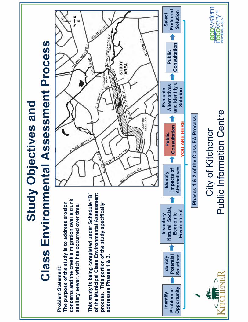
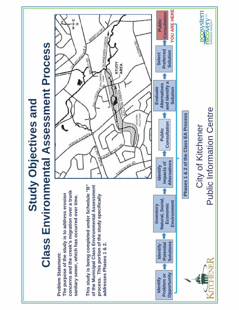
Study Objectives and Class Environmental Assessment Process
Identify Problem or Opportunity
Identify Potential Solutions
Public Consultation
Phases 1 & 2 of the Class EA Process
Inventory Natural, Social,
Economic Environment
Identify Impacts of
Alternatives
Evaluate Alternatives
and Identify a Solution
Select Preferred Solution
Problem Statement:The purpose of the study is to address erosion concerns and the creek’s migration over a trunk sanitary sewer, which has occurred over time.
This study is being completed under Schedule “B” of the Municipal Class Environmental Assessment process. This portion of the study specifically addresses Phases 1 & 2.
YOU ARE HERE
Public Consultation
09/06/2015
2
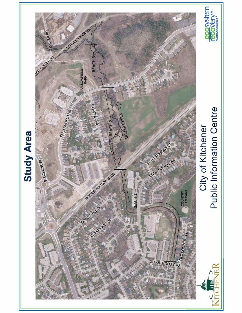
Study Area
City of KitchenerPublic Information Centre
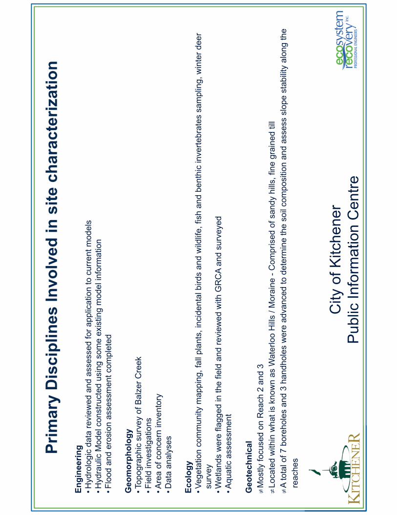
Primary Disciplines Involved in site characterization
City of KitchenerPublic Information Centre
Engineering• Hydrologic data reviewed and assessed for application to current models• Hydraulic Model constructed using some existing model information• Flood and erosion assessment completed
Geomorphology• Topographic survey of Balzer Creek• Field investigations• Area of concern inventory• Data analyses
Ecology• Vegetation community mapping, fall plants, incidental birds and wildlife, fish and benthic invertebrates sampling, winter deer survey
• Wetlands were flagged in the field and reviewed with GRCA and surveyed• Aquatic assessment
GeotechnicalMostly focused on Reach 2 and 3 Located within what is known as Waterloo Hills / Moraine - Comprised of sandy hills, fine grained tillA total of 7 boreholes and 3 handholes were advanced to determine the soil composition and assess slope stability along the
reaches
09/06/2015
3
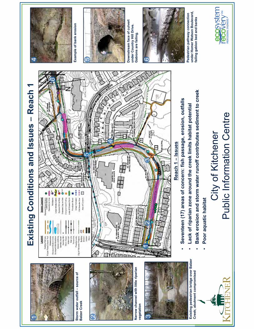
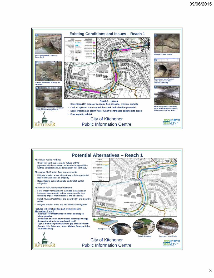
Existing Conditions and Issues – Reach 1
Reach 1 – Issues• Seventeen (17) areas of concern: fish passage, erosion, outfalls
• Lack of riparian zone around the creek limits habitat potential
• Bank erosion and storm water runoff contributes sediment to creek
• Poor aquatic habitat
Example of bank erosion
Downstream face of culvert under Country Hill Drive. Gabions are failing.
Pedestrian pathway connection under Homer Watson Boulevard, failing gabion bed and banks
Narrow channel with little riparian vegetation
Existing pedestrian bridge over Balzer Creek; abutment compromised
Storm water outfall – source of Balzer Creek
6
5
41
2
3
City of KitchenerPublic Information Centre
N
2 3
4
6
1
5
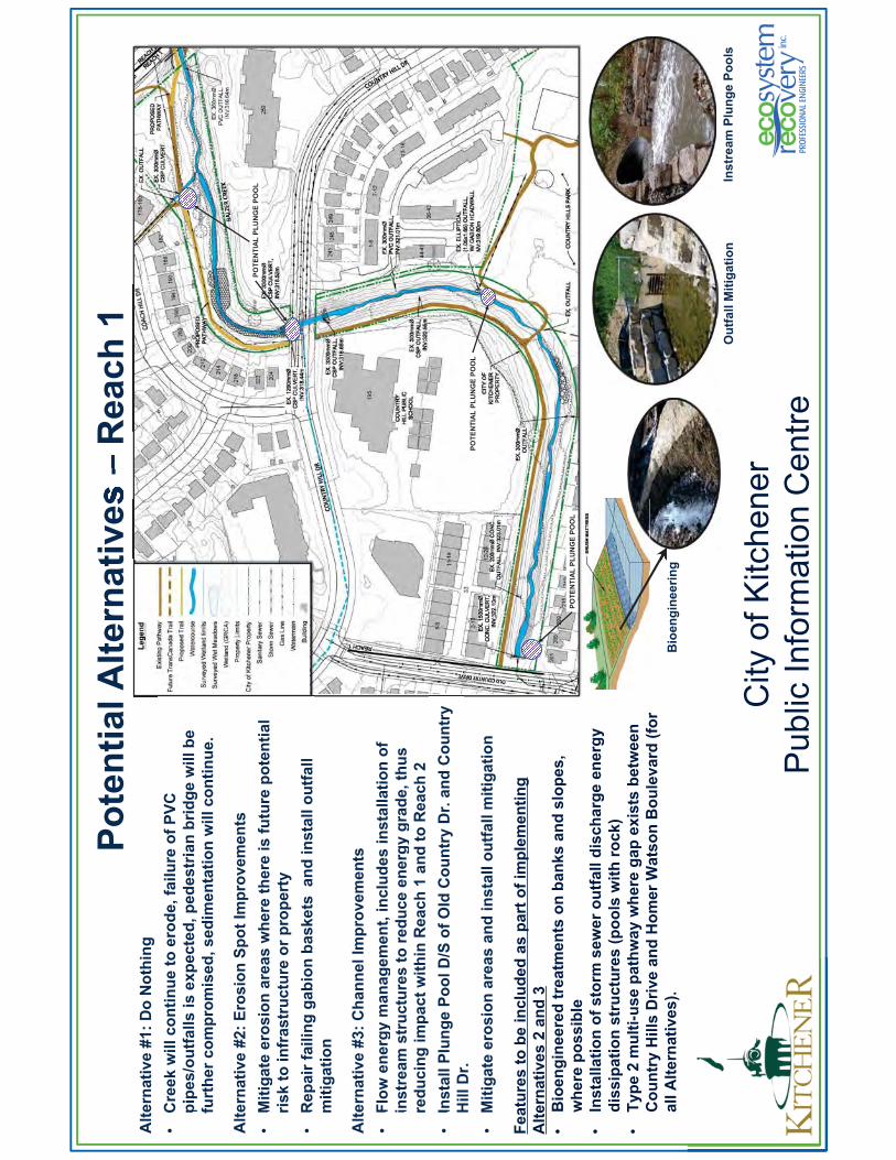
Potential Alternatives – Reach 1Alternative #1: Do Nothing
• Creek will continue to erode, failure of PVC pipes/outfalls is expected, pedestrian bridge will be further compromised, sedimentation will continue.
Alternative #2: Erosion Spot Improvements
• Mitigate erosion areas where there is future potential risk to infrastructure or property
• Repair failing gabion baskets and install outfall mitigation
Alternative #3: Channel Improvements
• Flow energy management, includes installation of instream structures to reduce energy grade, thus reducing impact within Reach 1 and to Reach 2
• Install Plunge Pool D/S of Old Country Dr. and Country Hill Dr.
• Mitigate erosion areas and install outfall mitigation
City of KitchenerPublic Information Centre
POTENTIAL PLUNGE POOL
POTENTIAL PLUNGE POOL
Features to be included as part of implementing Alternatives 2 and 3• Bioengineered treatments on banks and slopes,
where possible • Installation of storm sewer outfall discharge energy
dissipation structures (pools with rock)• Type 2 multi-use pathway where gap exists between
Country Hills Drive and Homer Watson Boulevard (for all Alternatives).
POTENTIAL PLUNGE POOL
Bioengineering
Outfall Mitigation Instream Plunge Pools
09/06/2015
4
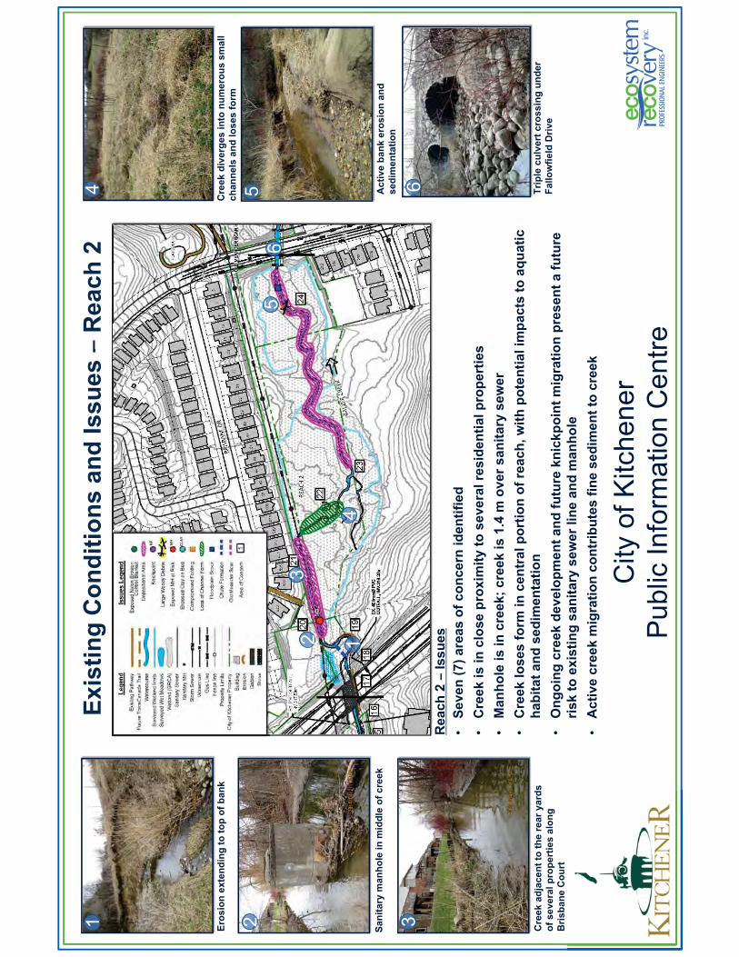
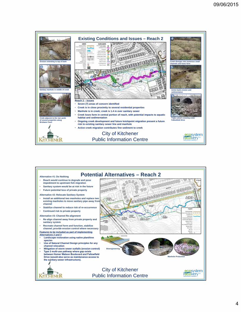
Reach 2 – Issues• Seven (7) areas of concern identified
• Creek is in close proximity to several residential properties
• Manhole is in creek; creek is 1.4 m over sanitary sewer
• Creek loses form in central portion of reach, with potential impacts to aquatic habitat and sedimentation
• Ongoing creek development and future knickpoint migration present a future risk to existing sanitary sewer line and manhole
• Active creek migration contributes fine sediment to creek
Existing Conditions and Issues – Reach 2
23
4
6
1
5
Creek diverges into numerous small channels and loses form
Active bank erosion and sedimentation
Triple culvert crossing under Fallowfield Drive
Sanitary manhole in middle of creek
Creek adjacent to the rear yards of several properties along Brisbane Court
Erosion extending to top of bank
6
5
41
2
3
City of KitchenerPublic Information Centre
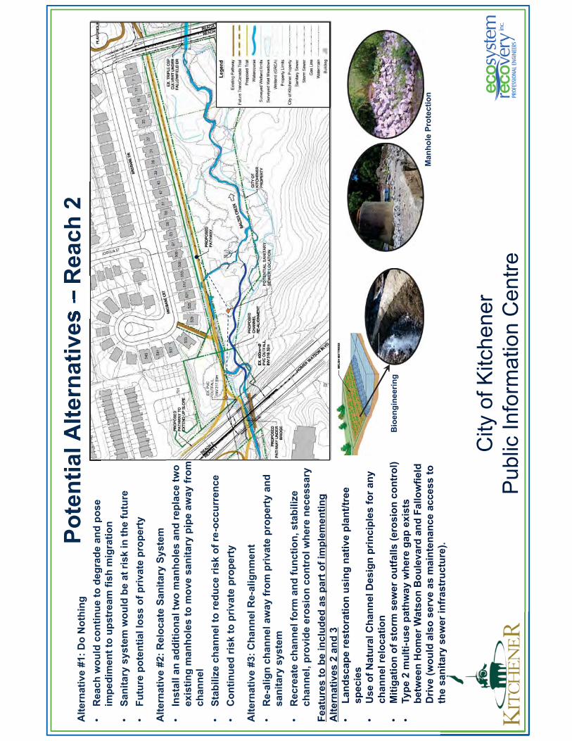
Potential Alternatives – Reach 2Alternative #1: Do Nothing
• Reach would continue to degrade and pose impediment to upstream fish migration
• Sanitary system would be at risk in the future
• Future potential loss of private property
Alternative #2: Relocate Sanitary System
• Install an additional two manholes and replace two existing manholes to move sanitary pipe away from channel
• Stabilize channel to reduce risk of re-occurrence
• Continued risk to private property
Alternative #3: Channel Re-alignment
• Re-align channel away from private property and sanitary system
• Recreate channel form and function, stabilize channel, provide erosion control where necessary
Features to be included as part of implementing Alternatives 2 and 3• Landscape restoration using native plant/tree
species• Use of Natural Channel Design principles for any
channel relocation• Mitigation of storm sewer outfalls (erosion control)• Type 2 multi-use pathway where gap exists
between Homer Watson Boulevard and FallowfieldDrive (would also serve as maintenance access to the sanitary sewer infrastructure).
City of KitchenerPublic Information Centre
POTENTIAL SANITARY SEWER LOCATION
Bioengineering
Manhole Protection
09/06/2015
5
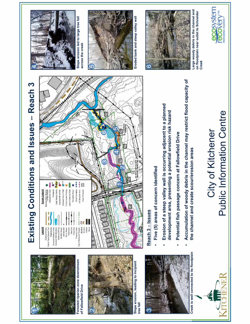
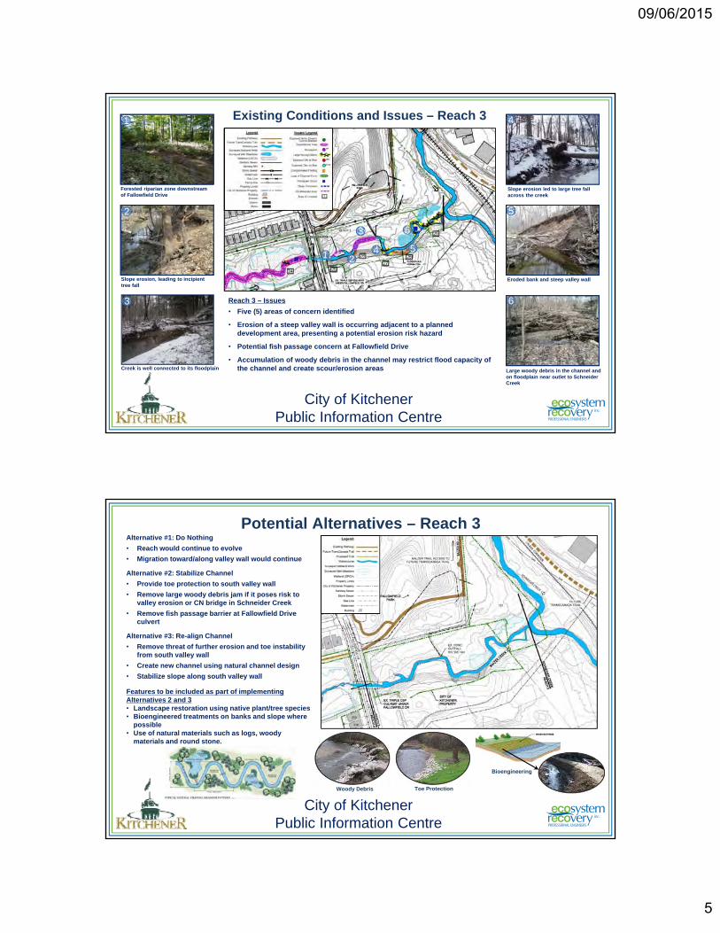
Existing Conditions and Issues – Reach 3
Reach 3 – Issues
• Five (5) areas of concern identified
• Erosion of a steep valley wall is occurring adjacent to a planned development area, presenting a potential erosion risk hazard
• Potential fish passage concern at Fallowfield Drive
• Accumulation of woody debris in the channel may restrict flood capacity of the channel and create scour/erosion areas
Slope erosion led to large tree fall across the creek
Eroded bank and steep valley wall
Large woody debris in the channel and on floodplain near outlet to Schneider Creek
Slope erosion, leading to incipient tree fall
Creek is well connected to its floodplain
Forested riparian zone downstream of Fallowfield Drive
6
5
41
2
3
City of KitchenerPublic Information Centre
2
3
4
6
15
Potential Alternatives – Reach 3Alternative #1: Do Nothing
• Reach would continue to evolve
• Migration toward/along valley wall would continue
Alternative #2: Stabilize Channel
• Provide toe protection to south valley wall
• Remove large woody debris jam if it poses risk to valley erosion or CN bridge in Schneider Creek
• Remove fish passage barrier at Fallowfield Drive culvert
Alternative #3: Re-align Channel
• Remove threat of further erosion and toe instability from south valley wall
• Create new channel using natural channel design
• Stabilize slope along south valley wall
Features to be included as part of implementing Alternatives 2 and 3• Landscape restoration using native plant/tree species• Bioengineered treatments on banks and slope where
possible• Use of natural materials such as logs, woody
materials and round stone.
City of KitchenerPublic Information Centre
Woody Debris Toe Protection
Bioengineering
09/06/2015
6
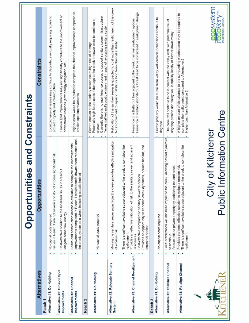
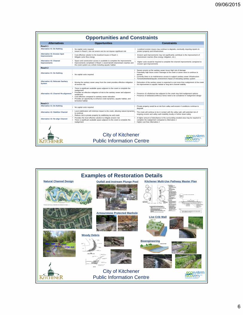
Opportunities and Constraints
City of KitchenerPublic Information Centre
Alternatives Opportunities ConstraintsReach 1Alternative #1: Do Nothing • No capital costs required
• Issues in Reach 1 are not severe and do not impose significant risk• Localized erosion issues may continue to degrade, eventually requiring repairs to
protect property and infrastructure
Alternative #2: Erosion Spot Improvements
• Cost-effective solution to the localized issues in Reach 1• Mitigate some flow energy
• Erosion spot improvements may not significantly contribute to the improvement of downstream reaches (flow energy mitigation, etc.)
Alternative #3: Channel Improvements
• Space and construction access is available to complete the improvements• Improvements completed in Reach 1 would benefit downstream reaches and
the creek system as a whole including aquatic habitat
• Higher costs would be required to complete the channel improvements compared to erosion spot improvements
Reach 2
Alternative #1: Do Nothing• No capital costs required
• Severe erosion at the sanitary sewer incurs high risk of damage• Potentially high future costs if damage to the creek or sewer were to continue to
worsen• Currently there is no maintenance access to support sanitary sewer infrastructure• Terrestrial/wetland/aquatic environment impact of relocating sanitary system
Alternative #2: Relocate Sanitary System
• Moving the sanitary sewer away from the creek provides effective mitigation of erosion risk
• Relocation of the sanitary sewer is expected to cost more than realignment of the creek• No improvement to aquatic habitat or long term channel stability
Alternative #3: Channel Re-alignment
• There is significant available space adjacent to the creek to complete the realignment
• Provides an effective mitigation of risk to the sanitary sewer and adjacent residences
• Cost-effective compared to sanitary sewer relocation• Provides an opportunity to enhance creek dynamics, aquatic habitat, and
terrestrial habitat
• Presence of a Butternut tree adjacent to the creek may limit realignment options• Presence of wetlands/coniferous forest need to be considered in realignment design
Reach 3Alternative #1: Do Nothing
• No capital costs required• Private property would be at risk from valley wall erosion if conditions continue to
degrade
Alternative #2: Stabilize Channel• Local stabilization will minimize impact to the creek, allowing natural dynamics
to continue• Reduce risk to private property by stabilizing toe and creek
• The creek will continue to be in contact with the valley wall, with potential risk of ongoing erosion and valley wall instability locally or further down-valley
Alternative #3: Re-align Channel • Provides the most effective solution to mitigate erosion risk • There is significant available space adjacent to the creek to complete the
realignment
• A higher amount of disturbance to the surrounding wooded area may be required to complete the realignment compared to Alternative 2
• Higher cost than Alternative 2
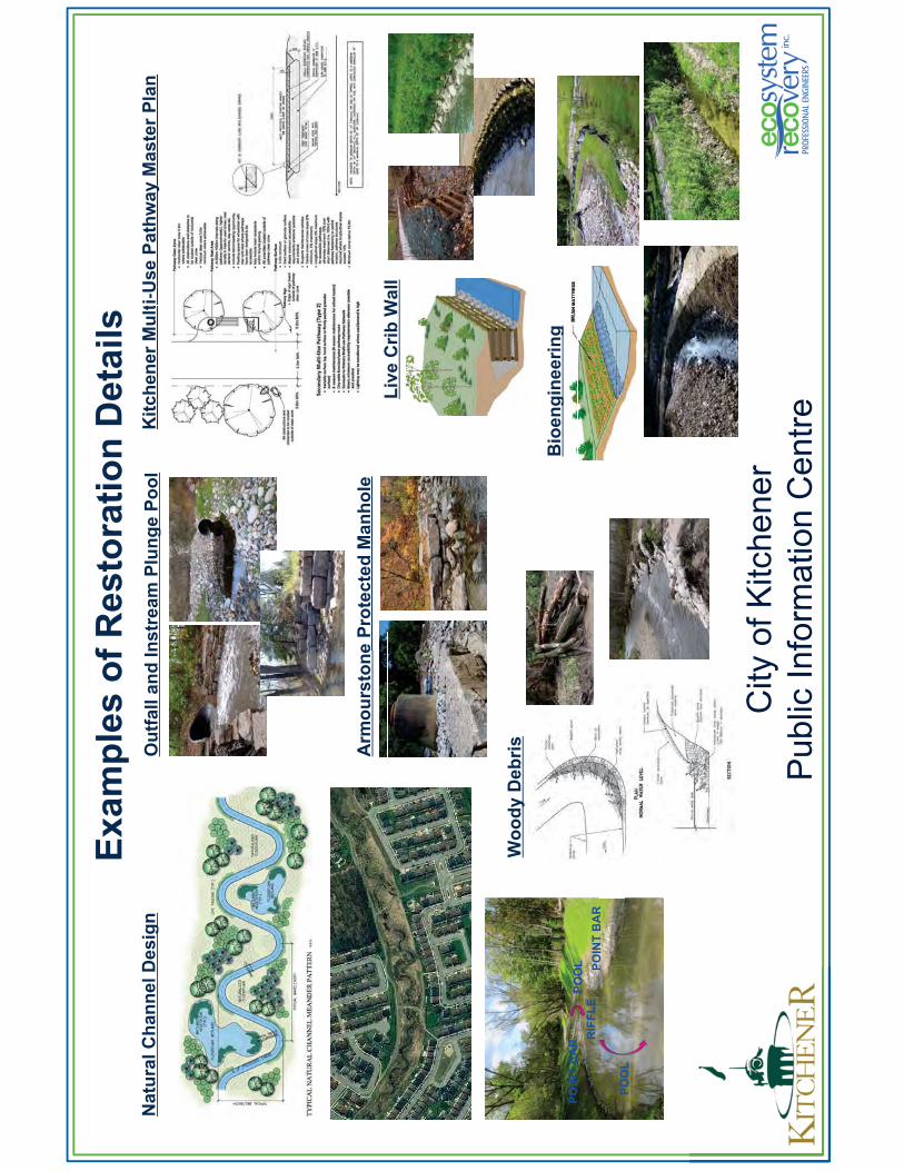
Examples of Restoration Details
City of KitchenerPublic Information Centre
Natural Channel Design
Live Crib Wall
POOL
POINT BARPOOL
RIFFLEPOINT BAR
Armourstone Protected Manhole
Woody Debris
Outfall and Instream Plunge Pool Kitchener Multi-Use Pathway Master Plan
Bioengineering
09/06/2015
7
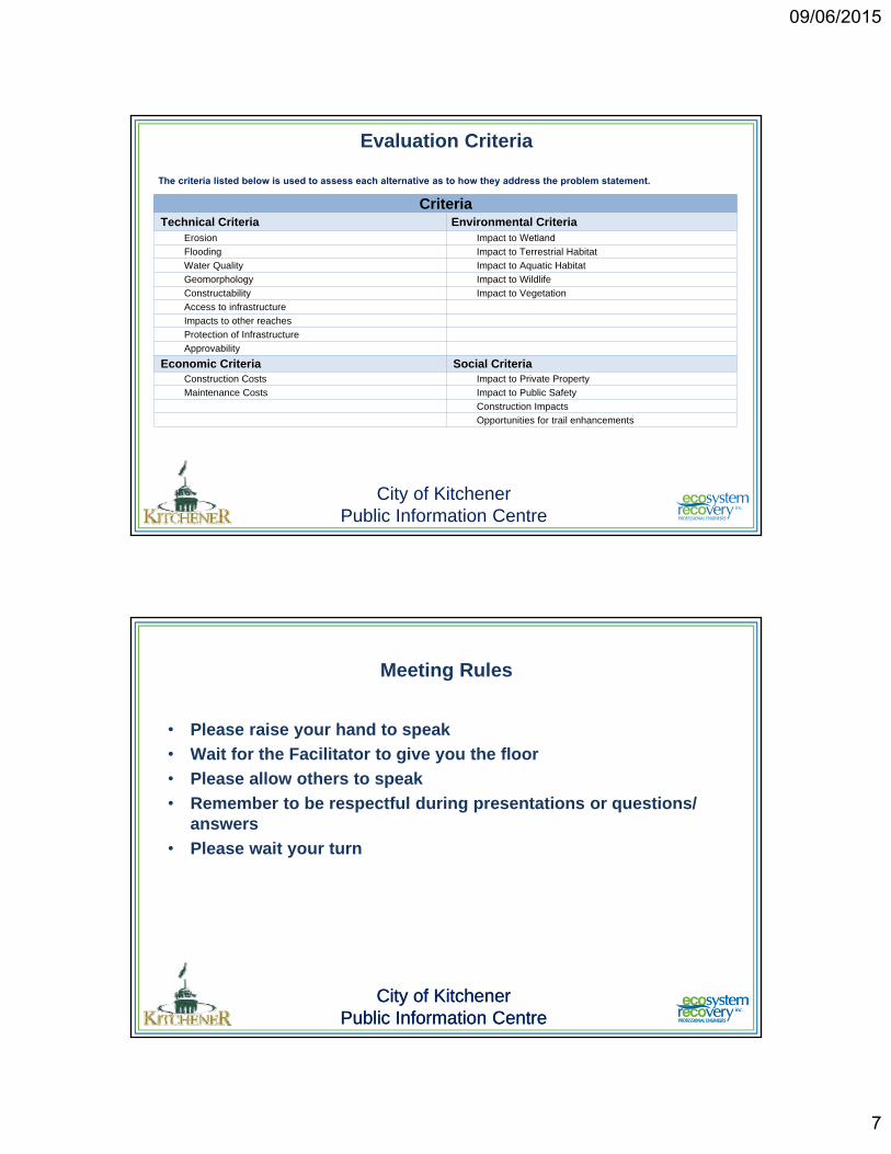
Evaluation Criteria
City of KitchenerPublic Information Centre
CriteriaTechnical Criteria Environmental Criteria
Erosion Impact to WetlandFlooding Impact to Terrestrial Habitat Water Quality Impact to Aquatic HabitatGeomorphology Impact to WildlifeConstructability Impact to VegetationAccess to infrastructureImpacts to other reachesProtection of InfrastructureApprovability
Economic Criteria Social CriteriaConstruction Costs Impact to Private PropertyMaintenance Costs Impact to Public Safety
Construction ImpactsOpportunities for trail enhancements
The criteria listed below is used to assess each alternative as to how they address the problem statement.
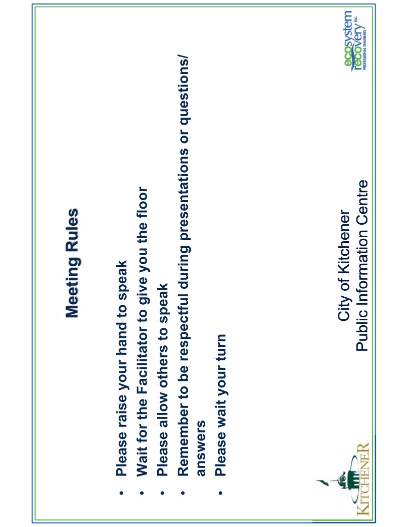
Meeting Rules
• Please raise your hand to speak• Wait for the Facilitator to give you the floor• Please allow others to speak• Remember to be respectful during presentations or questions/
answers• Please wait your turn
City of KitchenerPublic Information Centre
City of KitchenerPublic Information Centre
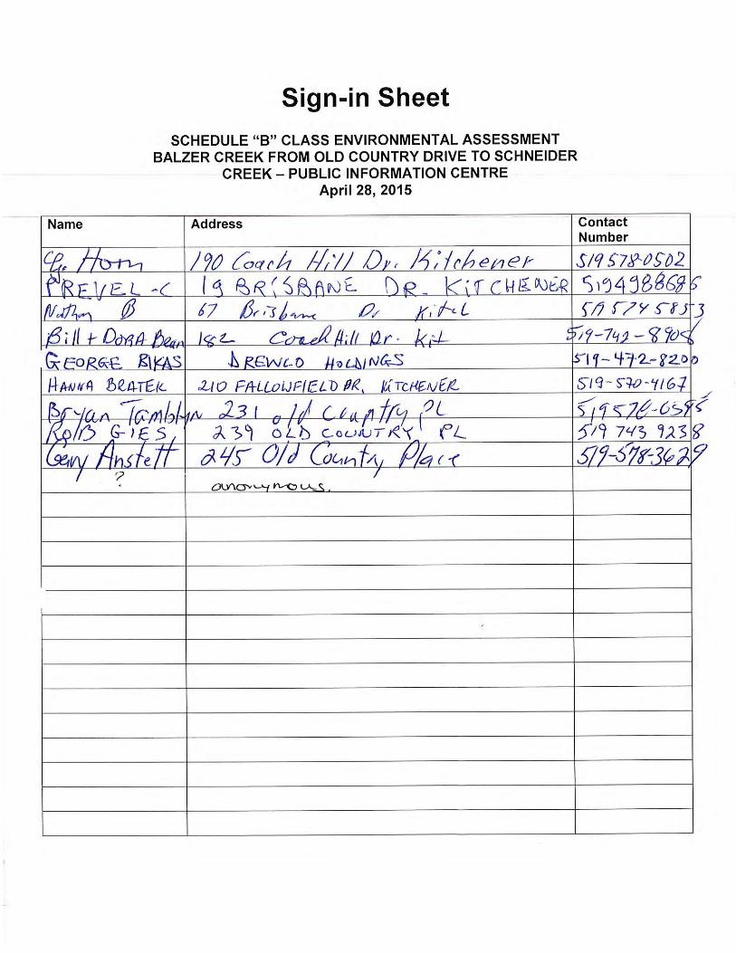
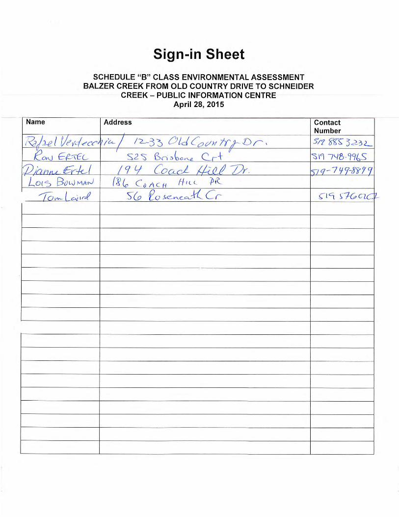
Public Information Centre 1 – April 28, 2015
After the formal presentation of the study by Ecosystem Recovery, a question and answer period was facilitated by the City of Kitchener. A summary of questions (Q) posed by members of the public and answers (A) provided by the City, Ecosystem Recovery (ERI), or Natural Resource Solutions Inc. (NRSI) is provided below. The source of question or answer is provided in brackets after each statement.
Q1. Country Hills Park, near the pedestrian bridge crossing of Balzer Creek, drains poorly. Six or seven years ago, the City tried to do something, but it is not working. Also, the stormwater outfall is half full of
water during low flow conditions; this must interfere with drainage effectiveness (Brian).
A1. The City will look into this further (City)
Q2. The drainage channel and/or the culvert under the trail are not big enough (i.e., of the outfall channel that runs near the Coach Hill Drive pathway to the valley). Water flood over, and has washed out, the trail. (Dora Bean).
A2. Noted. This will be added as an area of concern in the study (ERI)
Q3. In heavy rain, the creek widens 3 ft onto his property. If Alternative 2 was selected for Reach 2, then the flooding concern would not be addressed. The flooding affects at least 3 homes. (Ron E).
A3. We are looking at flooding as part of this study. The intent of any undertaking would be to
mitigate all issues in the vicinity. (ERI)
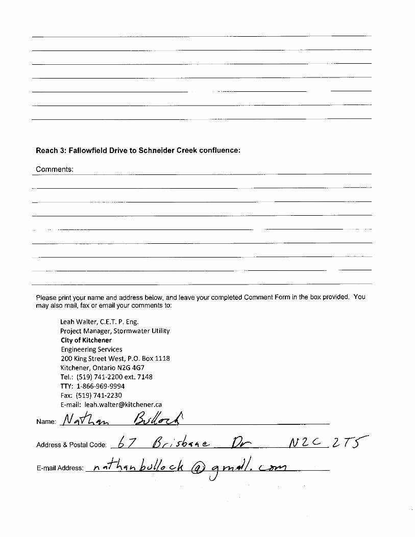
Q4. Are animals focussed on at all in this study? (Nathan B.)
A4. Yes, we are doing work in all seasons. We look at habitat and wildlife and know what is
good habitat. (NRSI)
Q5. Garbage is all along the reach (2) Shopping carts, concrete pipes, oil drums). Are there any plans to remove garbage? (Nathan B.)
A5. The stormwater utility group is working on improving maintenance. Please notify the City
anytime waste is noticed). One benefit of establishing a trail system is that it would be used to
gain access into the area and becomes part of a regular inspection route. (City)
Q6. I prefer that instead of spending money on the trail, that the money would to fixing safety issues at Home Watson and Block Line. (Nathan B.)
A6. The proposed trail system was established as a result of the collaboration of many members
of the public who felt that a trail would allow for safer walking and cycling opportunities. (City)
Q7. Sewer grates in Reach 2 used to be cleaned through use of an access road (Dora Bean)
A7. Yes, along Old Balzer Road, which is now in the location of homes along Brisbane Drive and
Brisbane Court. (ERI)
Q8. I have concerns regarding all the sand bars that are in the creek. The creek used to be full of leopard frogs and other wildlife. Over the last 15 years, we have lost wildlife, now I just see a few bullfrogs. (Dora)
A8. The sand accumulation comes from road runoff through the stormsewers and also from
instream erosion. There does appear to be excess sedimentation which has degraded aquatic
habitat. Managing the sand is a bigger issue related to storm water management that cannot
be addressed through this study alone. (ERI)
Q9. Do any of the sections qualify as PSWs (provincially significant wetlands)? (Lois)
A9. No, there are no PSWs. (NRSI)
Q10. Do plunge pools drain? (Lois)
A10. Yes, they are permanent structures. There is always a flow through of water and sediment
flushing capability during large storm events. (ERI)
Q11. Regarding the Master Trail process, there had been several meetings and there was no support for a trail in Reach 1, why is there one being proposed now?
A11. City recognizes that trail was opposed along Reach 1 previously and ‘shelved’ it. Now, it is
back because anytime a capital project overlaps with the trail concept plan, then the City is
required to look at the feasibility of implementing the trail. Some things have been changing in
the area (e.g., LRT) which may make it more desirable, from a resident perspective, to implement
the trail. (City)
Q12. I have concerns regarding trees, there needs to be money in budget to plant trees if any work is done. (Prevel)
A12. All alternatives are aware of a loss of trees. There is an opportunity to remove non‐native
trees and replace with native trees. The Conservation authority generally requires three trees to
be planted for every one tree that is removed. (NRSI, ERI)
Q13. There are trees that are flagged in Reach 2, are these going to be cut down? There are many trees
that are dying in the valley. (Hanna)
A13. The flagged trees may be those that were used to indicate the extent of the wetland, for
mapping purposes and are not intended to be cut down. The area includes Ash trees which are
at risk from the Emerald Ash Borer, and also Poplars which are not long lived trees. It is possible
that the dead trees are Ash and Poplar. (NRSI)
Q14. There are two (2) Butternut Trees in Reach 1, I will pass the information along. (Bill)
A14. Thank you. (NRSI)
Q15. What is the cost of putting down a gravel pathway? I would rather have the money be spent to
helping the stream. I would be more open to an asphalt walkway (i.e., gravel is not easy to navigate with mobility aids). (Bill)
A15. Cost for gravel path can range from $40 ‐ $100 per metre of path. Cost depends on site
conditions and the materials needed to create a base and the pathway. (City)
Q16. Will there be grass on either side of the trail? How wide? Now, home owners mow the grass, but wont do it if there is a gravel trail. (Dianne)
A16. Grass would be maintained by the City. The City discourages landowners from mowing but
recognizes that the City is not always able to maintain the area as well as residents can.
Q17. Will the proposed trail go to the opposite side of the creek? (Brian)
A17. No, the trail will remain where it is but, under Homer Watson, the trail would be moved to
the north side of the creek (under the bridge). (City).
Q18. If a trail goes in along the property line in Reach 2, will there be a fence or anything to keep kids off the property (i.e., kids hang out under the bridge a lot) (Ron).
A18. The City would try to impact residents as little as possible by moving the trail as far away
as possible to the property. Installation of fencing is left to the residents (City)
Q19. I would like to see trails that enable kids to cross under Homer Watson Boulevard rather than
crossing it. Can a trail go up to the sidewalk along the opposite side of Homer Watson? (G.)
A19. Yes, the City always wants to facilitate a safe way to cross the road. (City)
Q20. Are willows good creek bank stabilizers? (Dora)
A20. Yes, willows are good. Willow shrubs are better than trees. Willows are a common plant
used in bioengineering bank treatments (NRSI, ERI)
Q21. Would the trail be maintained, and lit? (Lois)
A21. No, the trail is not likely to lit. (City)
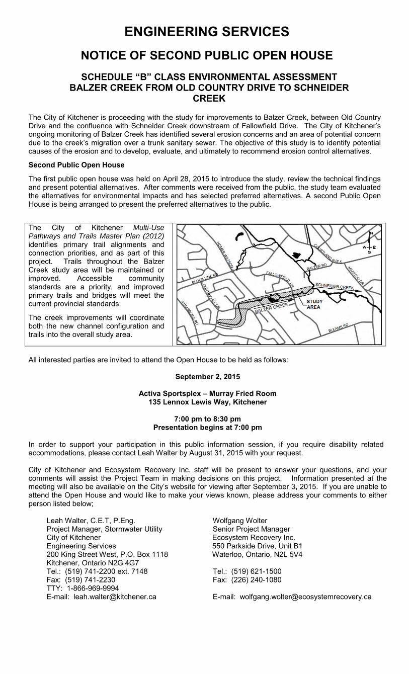
ENGINEERING SERVICES
NOTICE OF SECOND PUBLIC OPEN HOUSE
SCHEDULE “B” CLASS ENVIRONMENTAL ASSESSMENT BALZER CREEK FROM OLD COUNTRY DRIVE TO SCHNEIDER
CREEK
The City of Kitchener is proceeding with the study for improvements to Balzer Creek, between Old Country Drive and the confluence with Schneider Creek downstream of Fallowfield Drive. The City of Kitchener’s ongoing monitoring of Balzer Creek has identified several erosion concerns and an area of potential concern due to the creek’s migration over a trunk sanitary sewer. The objective of this study is to identify potential causes of the erosion and to develop, evaluate, and ultimately to recommend erosion control alternatives.
Second Public Open House
The first public open house was held on April 28, 2015 to introduce the study, review the technical findings and present potential alternatives. After comments were received from the public, the study team evaluated the alternatives for environmental impacts and has selected preferred alternatives. A second Public Open House is being arranged to present the preferred alternatives to the public.
The City of Kitchener Multi-Use Pathways and Trails Master Plan (2012) identifies primary trail alignments and connection priorities, and as part of this project. Trails throughout the Balzer Creek study area will be maintained or improved. Accessible community standards are a priority, and improved primary trails and bridges will meet the current provincial standards.
The creek improvements will coordinate both the new channel configuration and trails into the overall study area.
All interested parties are invited to attend the Open House to be held as follows:
September 2, 2015
Activa Sportsplex – Murray Fried Room 135 Lennox Lewis Way, Kitchener
7:00 pm to 8:30 pm
Presentation begins at 7:00 pm In order to support your participation in this public information session, if you require disability related accommodations, please contact Leah Walter by August 31, 2015 with your request. City of Kitchener and Ecosystem Recovery Inc. staff will be present to answer your questions, and your comments will assist the Project Team in making decisions on this project. Information presented at the meeting will also be available on the City’s website for viewing after September 3, 2015. If you are unable to attend the Open House and would like to make your views known, please address your comments to either person listed below;
Leah Walter, C.E.T, P.Eng. Wolfgang Wolter Project Manager, Stormwater Utility Senior Project Manager City of Kitchener Engineering Services 200 King Street West, P.O. Box 1118 Kitchener, Ontario N2G 4G7
Ecosystem Recovery Inc. 550 Parkside Drive, Unit B1 Waterloo, Ontario, N2L 5V4
Tel.: (519) 741-2200 ext. 7148 Tel.: (519) 621-1500 Fax: (519) 741-2230 Fax: (226) 240-1080 TTY: 1-866-969-9994 E-mail: [email protected] E-mail: [email protected]
City
of K
itche
ner
Pub
lic In
form
atio
n C
entr
e #2
Sep
tem
ber
2, 2
015
City
of K
itche
ner
Pub
lic In
form
atio
n C
entr
e
Stu
dy
Ob
ject
ives
an
d
Cla
ss E
nvi
ron
men
tal A
sses
smen
t P
roce
ss
Iden
tify
P
rob
lem
or
Op
po
rtu
nit
y
Iden
tify
P
ote
nti
al
So
luti
on
s
Pu
blic
C
on
sult
atio
n
Ph
ases
1 &
2 o
f th
e C
lass
EA
Pro
cess
Inve
nto
ry
Nat
ura
l, S
oci
al,
Eco
no
mic
E
nvi
ron
men
t
Iden
tify
Im
pac
ts o
f A
lter
nat
ives
Eva
luat
e A
lter
nat
ives
an
d Id
enti
fy a
S
olu
tio
n
Sel
ect
Pre
ferr
ed
So
luti
on
Pro
ble
m S
tate
men
t:T
he
pu
rpo
se o
f th
e st
ud
y is
to
ad
dre
ss e
rosi
on
co
nce
rns
and
th
e cr
eek’
s m
igra
tio
n o
ver
a tr
un
k sa
nit
ary
sew
er, w
hic
h h
as o
ccu
rred
ove
r ti
me.
Th
is s
tud
y is
bei
ng
co
mp
lete
d u
nd
er S
ched
ule
“B
” o
f th
e M
un
icip
al C
lass
En
viro
nm
enta
l Ass
essm
ent
pro
cess
. T
his
po
rtio
n o
f th
e st
ud
y sp
ecif
ical
ly
add
ress
es P
has
es 1
& 2
.
YO
U A
RE
HE
RE
Pu
blic
C
on
sult
atio
n
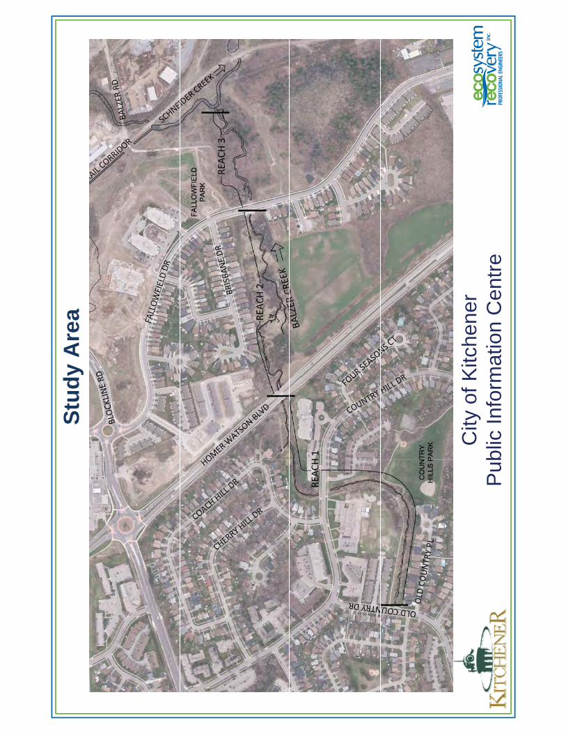
Stu
dy
Are
a
City
of K
itche
ner
Pub
lic In
form
atio
n C
entr
e
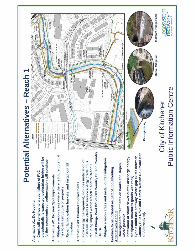
Po
ten
tial
Alt
ern
ativ
es –
Rea
ch 1
Alt
ern
ativ
e #1
: D
o N
oth
ing
•C
reek
will
co
nti
nu
e to
ero
de,
fai
lure
of
PV
C
pip
es/o
utf
alls
is e
xpec
ted
, ped
estr
ian
bri
dg
e w
ill b
e fu
rth
er c
om
pro
mis
ed, s
edim
enta
tio
n w
ill c
on
tin
ue.
Alt
ern
ativ
e #2
: E
rosi
on
Sp
ot
Imp
rove
men
ts
•M
itig
ate
ero
sio
n a
reas
wh
ere
ther
e is
fu
ture
po
ten
tial
ri
sk t
o in
fras
tru
ctu
re o
r p
rop
erty
•R
epai
r fa
ilin
g g
abio
n b
aske
ts a
nd
inst
all o
utf
all
mit
igat
ion
Alt
ern
ativ
e #3
: C
han
nel
Imp
rove
men
ts
•F
low
en
erg
y m
anag
emen
t, in
clu
des
inst
alla
tio
n o
f in
stre
am s
tru
ctu
res
to r
edu
ce e
ner
gy
gra
de,
th
us
red
uci
ng
imp
act
wit
hin
Rea
ch 1
an
d t
o R
each
2
•In
stal
l Plu
ng
e P
oo
l D/S
of
Old
Co
un
try
Dr.
an
d C
ou
ntr
y H
ill D
r.
•M
itig
ate
ero
sio
n a
reas
an
d in
stal
l ou
tfal
l mit
igat
ion
City
of K
itche
ner
Pub
lic In
form
atio
n C
entr
e
POTE
NTI
AL P
LUN
GE
POO
L
POTE
NTI
AL P
LUN
GE
POO
L
Fea
ture
s to
be
incl
ud
ed a
s p
art
of
imp
lem
enti
ng
A
lter
nat
ives
2 a
nd
3•
Bio
eng
inee
red
tre
atm
ents
on
ban
ks a
nd
slo
pes
, w
her
e p
oss
ible
•
Inst
alla
tio
n o
f st
orm
sew
er o
utf
all d
isch
arg
e en
erg
y d
issi
pat
ion
str
uct
ure
s (p
oo
ls w
ith
ro
ck)
•T
ype
2 m
ult
i-u
se p
ath
way
wh
ere
gap
exi
sts
bet
wee
n
Co
un
try
Hill
s D
rive
an
d H
om
er W
atso
n B
ou
leva
rd (
for
all A
lter
nat
ives
).
POTE
NTI
AL P
LUN
GE
POO
L
Bio
eng
inee
rin
g
Ou
tfal
l Mit
igat
ion
Inst
ream
Plu
ng
e P
oo
ls
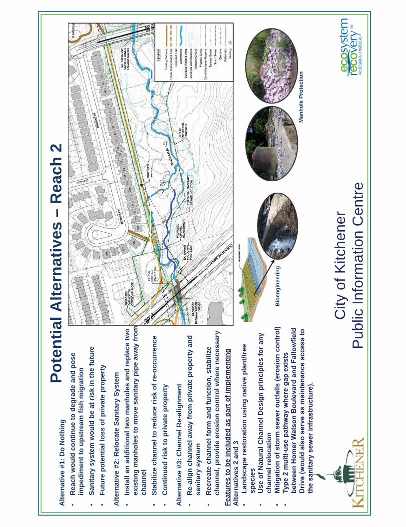
Po
ten
tial
Alt
ern
ativ
es –
Rea
ch 2
Alt
ern
ativ
e #1
: D
o N
oth
ing
•R
each
wo
uld
co
nti
nu
e to
deg
rad
e an
d p
ose
im
ped
imen
t to
up
stre
am f
ish
mig
rati
on
•S
anit
ary
syst
em w
ou
ld b
e at
ris
k in
th
e fu
ture
•F
utu
re p
ote
nti
al lo
ss o
f p
riva
te p
rop
erty
Alt
ern
ativ
e #2
: R
elo
cate
San
itar
y S
yste
m
•In
stal
l an
ad
dit
ion
al t
wo
man
ho
les
and
rep
lace
tw
o
exis
tin
g m
anh
ole
s to
mo
ve s
anit
ary
pip
e aw
ay f
rom
ch
ann
el
•S
tab
ilize
ch
ann
el t
o r
edu
ce r
isk
of
re-o
ccu
rren
ce
•C
on
tin
ued
ris
k to
pri
vate
pro
per
ty
Alt
ern
ativ
e #3
: C
han
nel
Re-
alig
nm
ent
•R
e-al
ign
ch
ann
el a
way
fro
m p
riva
te p
rop
erty
an
d
san
itar
y sy
stem
•R
ecre
ate
chan
nel
fo
rm a
nd
fu
nct
ion
, sta
bili
ze
chan
nel
, pro
vid
e er
osi
on
co
ntr
ol w
her
e n
eces
sary
Fea
ture
s to
be
incl
ud
ed a
s p
art
of
imp
lem
enti
ng
A
lter
nat
ives
2 a
nd
3•
Lan
dsc
ape
rest
ora
tio
n u
sin
g n
ativ
e p
lan
t/tr
ee
spec
ies
•U
se o
f N
atu
ral C
han
nel
Des
ign
pri
nci
ple
s fo
r an
y ch
ann
el r
elo
cati
on
•M
itig
atio
n o
f st
orm
sew
er o
utf
alls
(er
osi
on
co
ntr
ol)
•Ty
pe 2
mul
ti-us
e pa
thw
ay w
here
gap
exi
sts
betw
een
Hom
er W
atso
n B
oule
vard
and
Fal
low
field
Driv
e (w
ould
als
o se
rve
as m
aint
enan
ce a
cces
s to
th
e sa
nita
ry s
ewer
infr
astr
uctu
re).
City
of K
itche
ner
Pub
lic In
form
atio
n C
entr
e
POTE
NTI
AL S
ANIT
ARY
SE
WER
LO
CAT
ION
Bio
eng
inee
rin
g
Man
ho
le P
rote
ctio
n
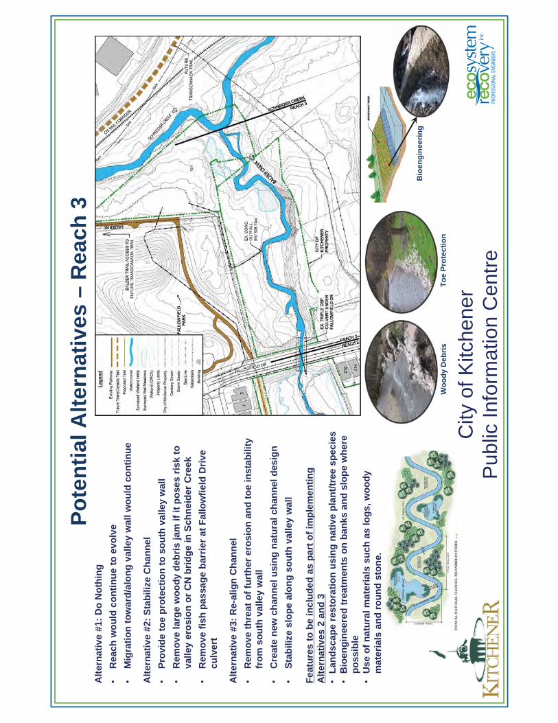
Po
ten
tial
Alt
ern
ativ
es –
Rea
ch 3
Alt
ern
ativ
e #1
: D
o N
oth
ing
•R
each
wo
uld
co
nti
nu
e to
evo
lve
•M
igra
tio
n t
ow
ard
/alo
ng
val
ley
wal
l wo
uld
co
nti
nu
e
Alt
ern
ativ
e #2
: S
tab
ilize
Ch
ann
el
•P
rovi
de
toe
pro
tect
ion
to
so
uth
val
ley
wal
l
•R
emo
ve la
rge
wo
od
y d
ebri
s ja
m if
it p
ose
s ri
sk t
o
valle
y er
osi
on
or
CN
bri
dg
e in
Sch
nei
der
Cre
ek
•R
emo
ve f
ish
pas
sag
e b
arri
er a
t F
allo
wfi
eld
Dri
ve
culv
ert
Alt
ern
ativ
e #3
: R
e-al
ign
Ch
ann
el
•R
emo
ve t
hre
at o
f fu
rth
er e
rosi
on
an
d t
oe
inst
abili
ty
fro
m s
ou
th v
alle
y w
all
•C
reat
e n
ew c
han
nel
usi
ng
nat
ura
l ch
ann
el d
esig
n
•S
tab
ilize
slo
pe
alo
ng
so
uth
val
ley
wal
l
Fea
ture
s to
be
incl
ud
ed a
s p
art
of
imp
lem
enti
ng
A
lter
nat
ives
2 a
nd
3•
Lan
dsc
ape
rest
ora
tio
n u
sin
g n
ativ
e p
lan
t/tr
ee s
pec
ies
•B
ioen
gin
eere
d t
reat
men
ts o
n b
anks
an
d s
lop
e w
her
e p
oss
ible
•U
se o
f n
atu
ral m
ater
ials
su
ch a
s lo
gs,
wo
od
y m
ater
ials
an
d r
ou
nd
sto
ne.
City
of K
itche
ner
Pub
lic In
form
atio
n C
entr
e
Wo
od
y D
ebri
sT
oe
Pro
tect
ion
Bio
eng
inee
rin
g
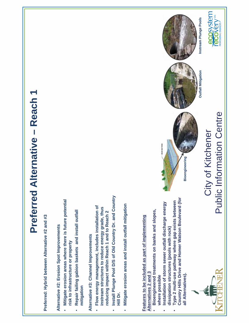
Pre
ferr
ed A
lter
nat
ive
–R
each
1P
refe
rred
: H
ybri
d b
etw
een
Alt
ern
ativ
e #2
an
d #
3
Alt
ern
ativ
e #2
: E
rosi
on
Sp
ot
Imp
rove
men
ts
•M
itig
ate
ero
sio
n a
reas
wh
ere
ther
e is
fu
ture
po
ten
tial
ri
sk t
o in
fras
tru
ctu
re o
r p
rop
erty
•R
epai
r fa
ilin
g g
abio
n b
aske
ts a
nd
inst
all o
utf
all
mit
igat
ion
Alt
ern
ativ
e #3
: C
han
nel
Imp
rove
men
ts
•F
low
en
erg
y m
anag
emen
t, in
clu
des
inst
alla
tio
n o
f in
stre
am s
tru
ctu
res
to r
edu
ce e
ner
gy
gra
de,
th
us
red
uci
ng
imp
act
wit
hin
Rea
ch 1
an
d t
o R
each
2
•In
stal
l Plu
ng
e P
oo
l D/S
of
Old
Co
un
try
Dr.
an
d C
ou
ntr
y H
ill D
r.
•M
itig
ate
ero
sio
n a
reas
an
d in
stal
l ou
tfal
l mit
igat
ion
City
of K
itche
ner
Pub
lic In
form
atio
n C
entr
e
Fea
ture
s to
be
incl
ud
ed a
s p
art
of
imp
lem
enti
ng
A
lter
nat
ives
2 a
nd
3•
Bio
eng
inee
red
tre
atm
ents
on
ban
ks a
nd
slo
pes
, w
her
e p
oss
ible
•
Inst
alla
tio
n o
f st
orm
sew
er o
utf
all d
isch
arg
e en
erg
y d
issi
pat
ion
str
uct
ure
s (p
oo
ls w
ith
ro
ck)
•T
ype
2 m
ult
i-u
se p
ath
way
wh
ere
gap
exi
sts
bet
wee
n
Co
un
try
Hill
s D
rive
an
d H
om
er W
atso
n B
ou
leva
rd (
for
all A
lter
nat
ives
).B
ioen
gin
eeri
ng
Ou
tfal
l Mit
igat
ion
Inst
ream
Plu
ng
e P
oo
ls
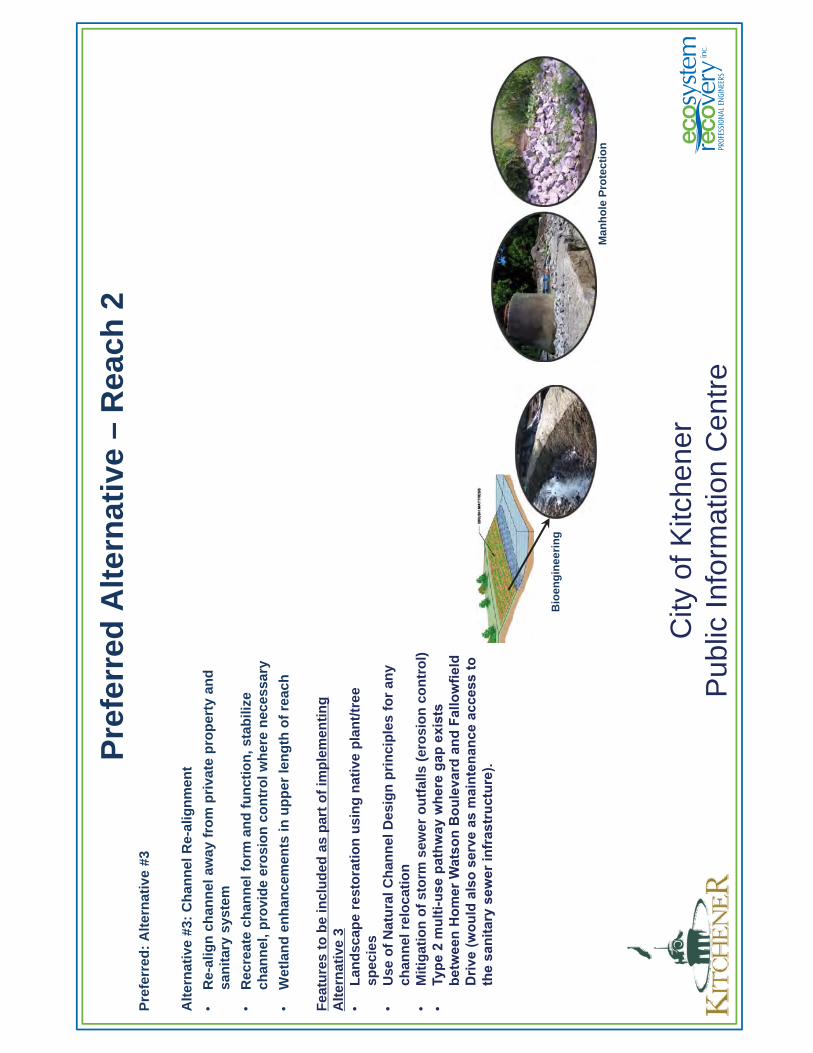
Pre
ferr
ed A
lter
nat
ive
–R
each
2P
refe
rred
: A
lter
nat
ive
#3
Alt
ern
ativ
e #3
: C
han
nel
Re-
alig
nm
ent
•R
e-al
ign
ch
ann
el a
way
fro
m p
riva
te p
rop
erty
an
d
san
itar
y sy
stem
•R
ecre
ate
chan
nel
fo
rm a
nd
fu
nct
ion
, sta
bili
ze
chan
nel
, pro
vid
e er
osi
on
co
ntr
ol w
her
e n
eces
sary
•W
etla
nd
en
han
cem
ents
in u
pp
er le
ng
th o
f re
ach
Fea
ture
s to
be
incl
ud
ed a
s p
art
of
imp
lem
enti
ng
A
lter
nat
ive
3•
Lan
dsc
ape
rest
ora
tio
n u
sin
g n
ativ
e p
lan
t/tr
ee
spec
ies
•U
se o
f N
atu
ral C
han
nel
Des
ign
pri
nci
ple
s fo
r an
y ch
ann
el r
elo
cati
on
•M
itig
atio
n o
f st
orm
sew
er o
utf
alls
(er
osi
on
co
ntr
ol)
•Ty
pe 2
mul
ti-us
e pa
thw
ay w
here
gap
exi
sts
betw
een
Hom
er W
atso
n B
oule
vard
and
Fal
low
field
Driv
e (w
ould
als
o se
rve
as m
aint
enan
ce a
cces
s to
th
e sa
nita
ry s
ewer
infr
astr
uctu
re).
City
of K
itche
ner
Pub
lic In
form
atio
n C
entr
e
Bio
eng
inee
rin
g
Man
ho
le P
rote
ctio
n
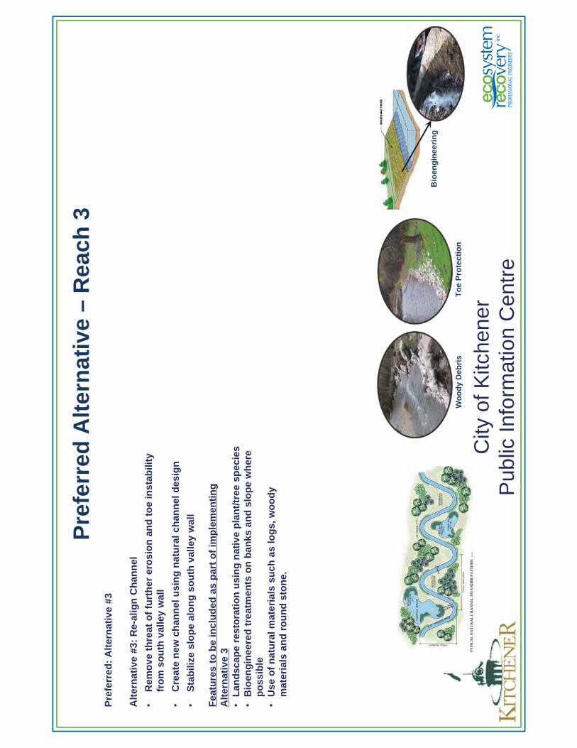
Pre
ferr
ed A
lter
nat
ive
–R
each
3P
refe
rred
: A
lter
nat
ive
#3
Alt
ern
ativ
e #3
: R
e-al
ign
Ch
ann
el
•R
emo
ve t
hre
at o
f fu
rth
er e
rosi
on
an
d t
oe
inst
abili
ty
fro
m s
ou
th v
alle
y w
all
•C
reat
e n
ew c
han
nel
usi
ng
nat
ura
l ch
ann
el d
esig
n
•S
tab
ilize
slo
pe
alo
ng
so
uth
val
ley
wal
l
Fea
ture
s to
be
incl
ud
ed a
s p
art
of
imp
lem
enti
ng
A
lter
nat
ive
3•
Lan
dsc
ape
rest
ora
tio
n u
sin
g n
ativ
e p
lan
t/tr
ee s
pec
ies
•B
ioen
gin
eere
d t
reat
men
ts o
n b
anks
an
d s
lop
e w
her
e p
oss
ible
•U
se o
f n
atu
ral m
ater
ials
su
ch a
s lo
gs,
wo
od
y m
ater
ials
an
d r
ou
nd
sto
ne.
City
of K
itche
ner
Pub
lic In
form
atio
n C
entr
e
Wo
od
y D
ebri
sT
oe
Pro
tect
ion
Bio
eng
inee
rin
g
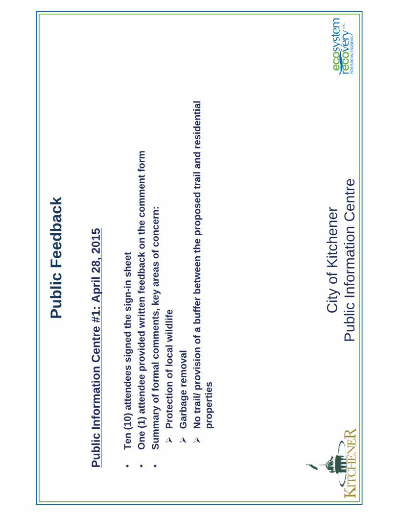
Pu
blic
Fee
db
ack
City
of K
itche
ner
Pub
lic In
form
atio
n C
entr
e
Pu
blic
Info
rmat
ion
Cen
tre
#1:
Ap
ril 2
8, 2
015
•T
en (
10)
atte
nd
ees
sig
ned
th
e si
gn
-in
sh
eet
•O
ne
(1)
atte
nd
ee p
rovi
ded
wri
tten
fee
db
ack
on
th
e co
mm
ent
form
•S
um
mar
y o
f fo
rmal
co
mm
ents
, key
are
as o
f co
nce
rn:
Pro
tect
ion
of
loca
l wild
life
Gar
bag
e re
mo
val
No
tra
il/ p
rovi
sio
n o
f a
bu
ffer
bet
wee
n t
he
pro
po
sed
tra
il an
d r
esid
enti
al
pro
per
ties
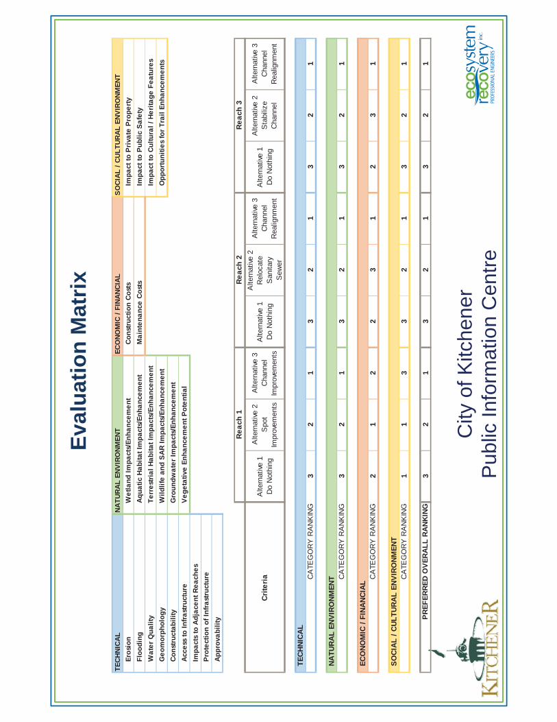
Eva
luat
ion
Mat
rix
City
of K
itche
ner
Pub
lic In
form
atio
n C
entr
e
TE
CH
NIC
AL
NA
TU
RA
L E
NV
IRO
NM
EN
TE
CO
NO
MIC
/ F
INA
NC
IAL
SO
CIA
L /
CU
LT
UR
AL
EN
VIR
ON
ME
NT
Ero
sio
nW
etl
an
d I
mp
act
s/E
nh
an
cem
en
tC
on
stru
ctio
n C
ost
sIm
pa
ct t
o P
riva
te P
rop
ert
y
Flo
od
ing
Aq
ua
tic
Ha
bit
at
Imp
act
s/E
nh
an
cem
en
tM
ain
ten
an
ce C
ost
sIm
pa
ct t
o P
ub
lic
Sa
fety
Wa
ter
Qu
ali
tyT
err
est
ria
l H
ab
ita
t Im
pa
cts/
En
ha
nce
me
nt
Imp
act
to
Cu
ltu
ral
/ H
eri
tag
e F
ea
ture
s
Ge
om
orp
ho
log
yW
ild
life
an
d S
AR
Im
pa
cts/
En
ha
nce
me
nt
Op
po
rtu
nit
ies
for
Tra
il E
nh
an
cem
en
ts
Co
nst
ruct
ab
ilit
yG
rou
nd
wa
ter
Imp
act
s/E
nh
an
cem
en
t
Acc
ess
to
In
fra
stru
ctu
reV
eg
eta
tive
En
ha
nce
me
nt
Po
ten
tia
l
Imp
act
s to
Ad
jace
nt
Re
ach
es
Pro
tect
ion
of
Infr
ast
ruct
ure
Ap
pro
vab
ilit
y
Cri
teri
aA
ltern
ativ
e 1
D
o N
othi
ng
Alte
rnat
ive
2
Spo
t Im
prov
emen
ts
Alte
rnat
ive
3 C
hann
el
Impr
ovem
ents
Alte
rnat
ive
1
Do
Not
hing
Alte
rnat
ive
2
Rel
ocat
e S
anita
ry
Sew
er
Alte
rnat
ive
3 C
hann
el
Rea
lignm
ent
Alte
rnat
ive
1
Do
Not
hing
Alte
rnat
ive
2
Sta
biliz
e C
hann
el
Alte
rnat
ive
3 C
hann
el
Rea
lignm
ent
32
13
21
32
1
32
13
21
32
1
21
22
31
23
1
11
33
21
32
1
32
13
21
32
1
Re
ach
1R
ea
ch 2
Re
ach
3
TE
CH
NIC
AL
CA
TEG
OR
Y R
AN
KIN
G
CA
TEG
OR
Y R
AN
KIN
G
NA
TU
RA
L E
NV
IRO
NM
EN
T CA
TEG
OR
Y R
AN
KIN
G
EC
ON
OM
IC /
FIN
AN
CIA
L
PR
EF
ER
RE
D O
VE
RA
LL
RA
NK
ING
SO
CIA
L /
CU
LT
UR
AL
EN
VIR
ON
ME
NT
CA
TEG
OR
Y R
AN
KIN
G
Co
nta
ct In
form
atio
n
Cit
y o
f K
itch
ener
Lea
h W
alte
r, C
.E.T
, P.E
ng
.P
roje
ct M
anag
er, S
torm
wat
er U
tilit
yC
ity
of
Kit
chen
er, E
ng
inee
rin
g S
ervi
ces
200
Kin
g S
tree
t W
est,
P.O
. Bo
x 11
18K
itch
ener
, On
tari
o N
2G 4
G7
Tel
.: (
519)
741
-220
0 ex
t. 7
148
Fax
: (
519)
741
-223
0T
TY
: 1
-866
-969
-999
4E
-mai
l: l
eah
.wal
ter@
kitc
hen
er.c
a City
of K
itche
ner
Pub
lic In
form
atio
n C
entr
eC
ity o
f Kitc
hene
rP
ublic
Info
rmat
ion
Cen
tre
Eco
syst
em R
eco
very
Inc.
Wo
lfg
ang
Wo
lter
S
enio
r P
roje
ct M
anag
er
Eco
syst
em R
eco
very
Inc.
55
0 P
arks
ide
Dri
ve, U
nit
B1
Wat
erlo
o, O
nta
rio
N2L
5V
4T
el.:
(51
9) 6
21-1
500
Fax
: (
226)
240
-108
0T
TY
: 1
-866
-969
-999
4E
-mai
l: w
olf
gan
g.w
olt
er@
eco
syst
emre
cove
ry.c
a
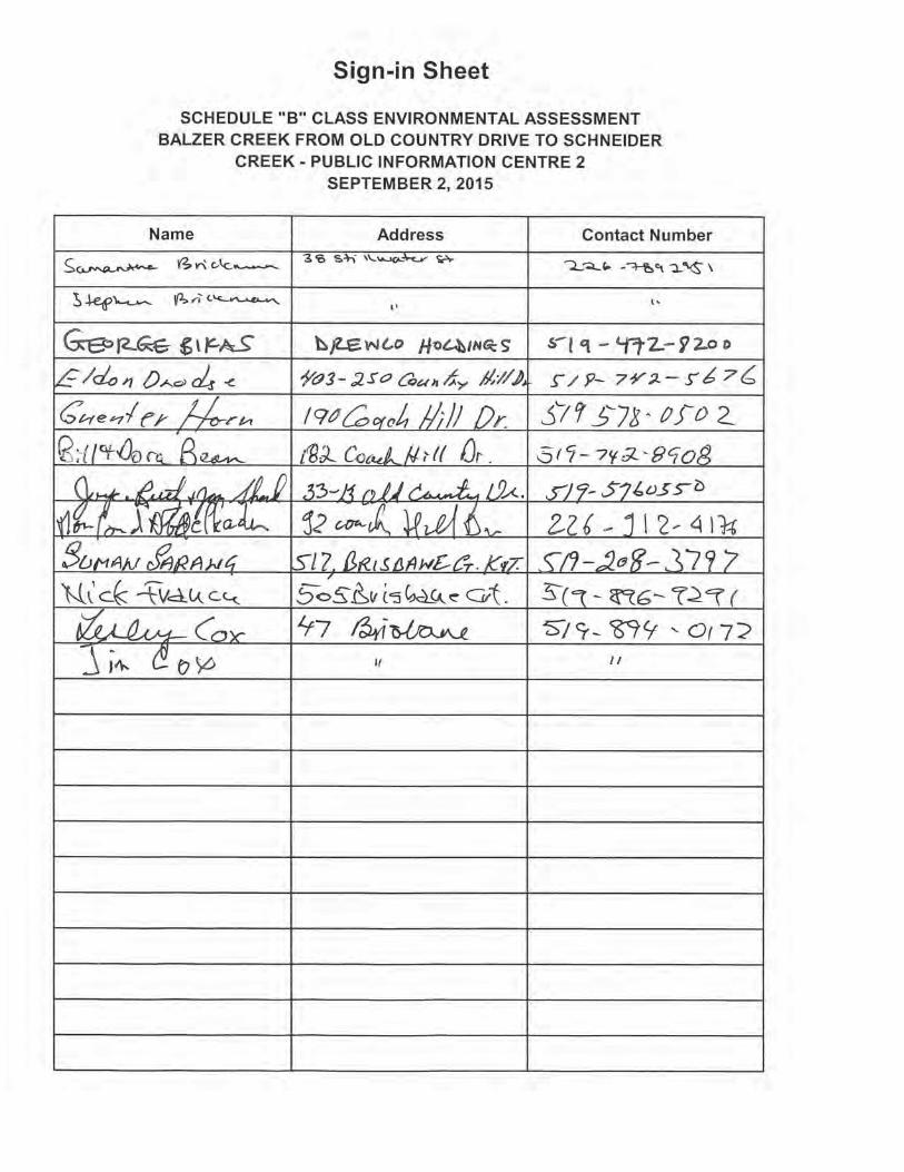
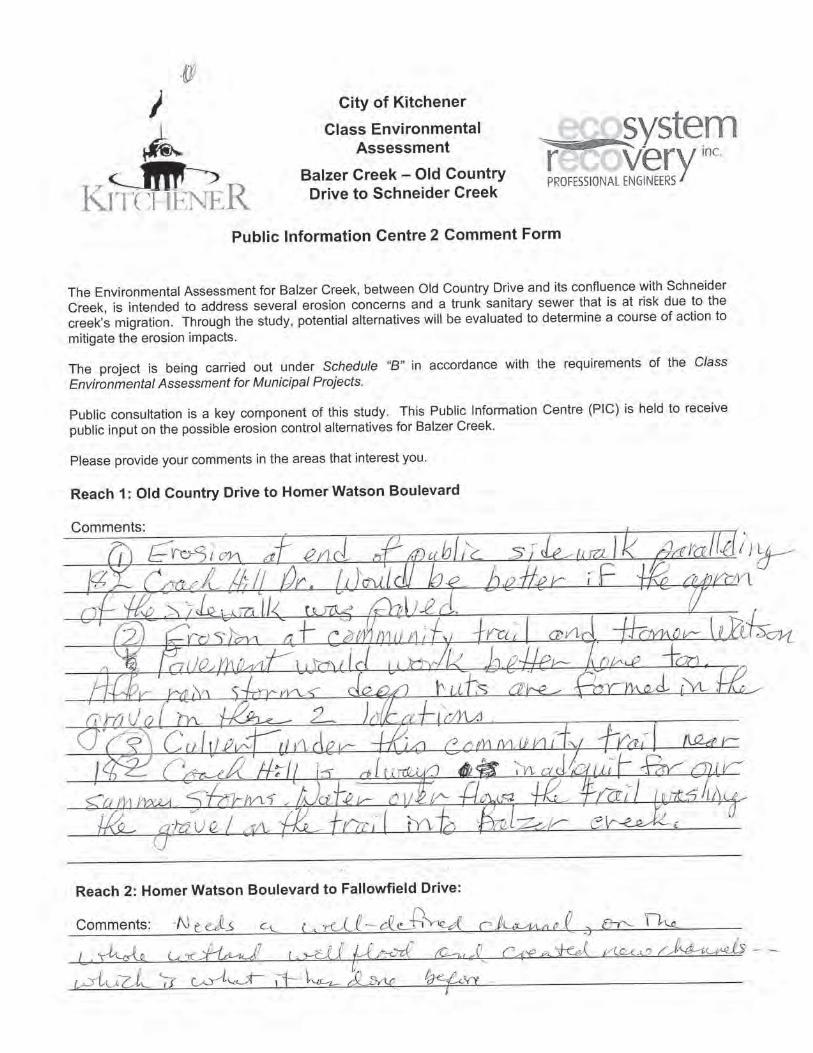
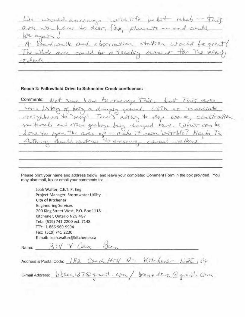
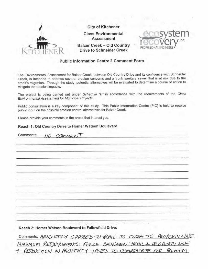
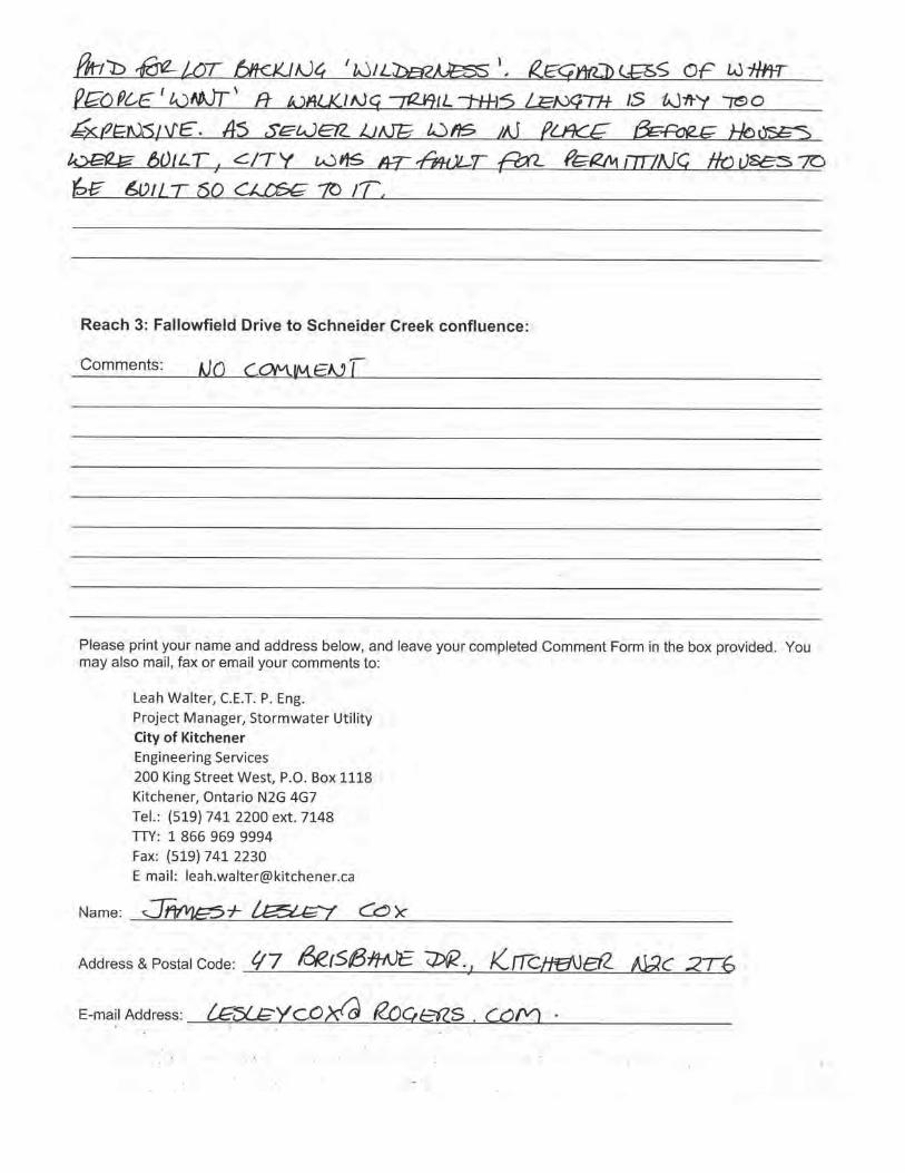
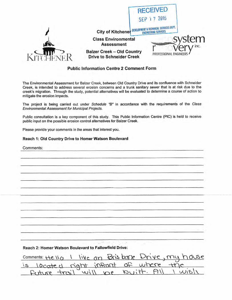
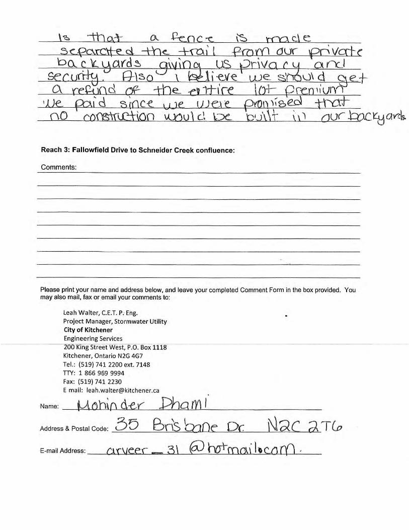
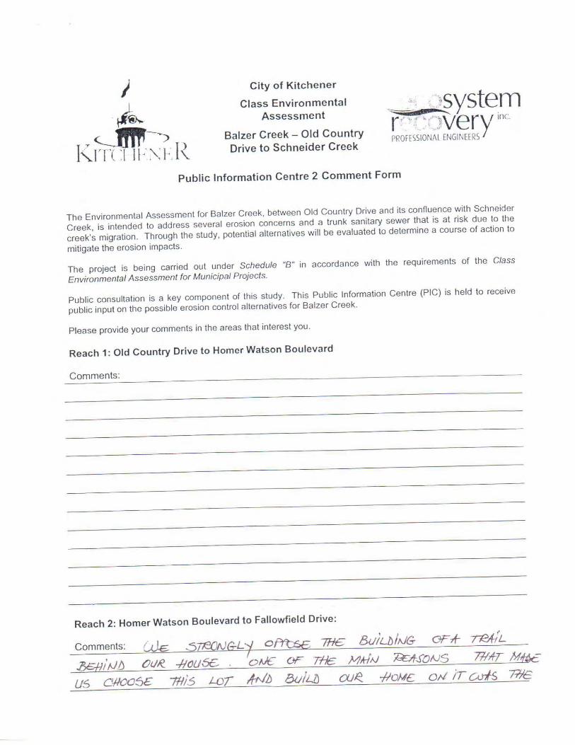
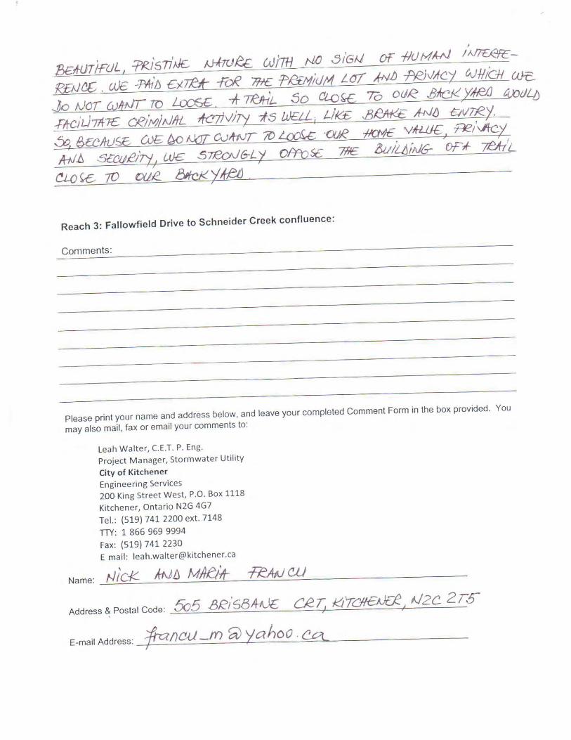
1
Rebecca Swabey
From: [email protected]: Wednesday, May 13, 2015 8:07 AMTo: Wolfgang WolterCc: [email protected]: Fw: Balzer Creek Class Environmental assessment - comments
Fyi Sent from my BlackBerry 10 smartphone on the Bell network.
From: L Bowman <[email protected]> Sent: Tuesday, May 12, 2015 8:08 PM To: Leah Walter Subject: Balzer Creek Class Environmental assessment - comments Hi Leah thank you for the opportunity to hear about plans for Balzer creek at the recent public open house. my comments are with respect to Reach 1. I don't believe that a stone dust path beside the creek is the best surface for the walking, running, dog walking, bicycling and playing that occurs behind our house currently. If transportation from point A to point B is one of the objectives of connecting trailways, transportation is already possible and happening in the modes mentioned above throughout the day with the existing grass surface, so it doesn't seem necessary to spend money putting in a new surface. Stone dust would not make the trail any more accessible that it is currently, and can create a mess alongside the path, by being scattered, and would be subject to washing away. There's no plan for winter maintenance, so there's nothing wrong with keeping the existing grass surface. I would prefer you to keep a grass surface on Reach 1 trailway. thanks Lois Bowman 186 Coach Hill Drive Kitchener N2E 1P4
1
Rebecca Swabey
From: Wolfgang WolterSent: Thursday, October 8, 2015 7:55 AMTo: Rebecca SwabeySubject: Fw: Balzer Creek
‐‐‐‐‐Original Message‐‐‐‐‐ From: Ron Ertel Sent: Thursday, September 17, 2015 12:38 AM To: Matt Wilson Subject: RE: Balzer Creek Hi Matt, I just read the Preferred Alternative from the Sept 2nd meeting I was unable to attend, in regards to the plans for Balzer Creek. I am one of the residents at 525 Brisbane Crt in Reach 2, the 2nd house to the right of the path that comes up from the creek to our Court. The Box showing "Old Channel to be filled" on the map. We had a few questions in regards to the Re‐alignment: 1) How far off our property line with the path be ? 2) What is being planted between the path and our property for privacy and how close will the plantings be? We have concerns about privacy and trespassing with the path so close to us (dogs on our property that could affect our dog. We become more vulnerable with people walking behind our home especially at night when it is dark). 3) What will happen to existing vegetation ‐ will they try to leave existing large trees? It'll take years for newly planted trees and shrubs to become substantial. We have a lot of shrubbery and plants right along our property line which would at least give us some privacy. Now we will lose that. 4) How far will the new creek extend into the field? How much of the land is protected behind our property? 5) How far will the creek be from our property? 6) Teenagers currently hang out under the Homer Watson bridge a lot and making lots of noise. What's being done to try and discourage them from hanging out there? Thanks, Ron Ertel Lead‐hand of Event Operations ‐ KMAC | Enterprise Division | City of Kitchener ‐ The Aud Ph: 519‐741‐2200 Ext. 5275 | TTY 1‐866‐969‐9994 | [email protected]
2
‐‐‐‐‐Original Message‐‐‐‐‐ From: Leah Walter Sent: Wednesday, September 09, 2015 4:42 PM To: Ron Ertel Cc: Matt Wilson Subject: RE: Balzer Creek Hi Ron, We are waiting for communications to approve the uploaded information to the website so this should be done by tomorrow or friday. I will be on maternity leave starting next Friday so if you would like to contact Matt Wilson for anything related to this project, feel free to do so. Thanks! Leah Walter, C.E.T., P.Eng Project Manager, Stormwater Utility | Engineering Division | City of Kitchener P 519‐741‐2200 x 7148 | TTY 1‐866‐969‐9994 | [email protected] CONNECT WITH US: kitchener.ca | contact centre | facebook | twitter | pingstreet | youtube | flickr ‐‐‐‐‐Original Message‐‐‐‐‐ From: Ron Ertel Sent: Wednesday, September 09, 2015 11:23 AM To: Leah Walter Subject: Balzer Creek Hi Leah, I am one of the residents that backs onto Balzer Creek, just a couple houses in from Homer Watson on the Fallowfield side. I was unable to attend last weeks meeting, and was wondering if you have anything posted on the website or could let me know what was discussed, as far as a review of the meeting? Thanks, Ron Ertel Lead‐hand of Event Operations | Enterprise Division | City of Kitchener ‐ The Aud Ph:519‐741‐2200 Ext 5275 | TTY: 1‐866‐969‐9994 | [email protected] CONNECT WITH US: www.kitchener.ca www.kitchener.ca/connect www.facebook.com/cityofkitchener http://twitter.com/citykitchener www.kitchener.ca/pingstreet www.youtube.com/cityofkitchener www.flckr.com/cityofkitchener

3
www.kitchener.ca/en/insidecityhall/Text_us.asp
1
Rebecca Swabey
From: Wolfgang WolterSent: Thursday, October 8, 2015 7:57 AMTo: Rebecca SwabeySubject: Fw: Balzer Creek
‐‐‐‐‐Original Message‐‐‐‐‐ From: Ron Ertel Sent: Thursday, September 17, 2015 12:38 AM To: Matt Wilson Subject: RE: Balzer Creek Hi Matt, I just read the Preferred Alternative from the Sept 2nd meeting I was unable to attend, in regards to the plans for Balzer Creek. I am one of the residents at 525 Brisbane Crt in Reach 2, the 2nd house to the right of the path that comes up from the creek to our Court. The Box showing "Old Channel to be filled" on the map. We had a few questions in regards to the Re‐alignment: 1) How far off our property line with the path be ? The path is planned to be placed within the existing sanitary sewer easement to allow for future infrastructure maintenance and repair. The centreline of the path would be in the order of 7m from the property line at the back of the properties in that area. 2) What is being planted between the path and our property for privacy and how close will the plantings be? We have concerns about privacy and trespassing with the path so close to us (dogs on our property that could affect our dog. We become more vulnerable with people walking behind our home especially at night when it is dark). The extent and nature of the planting at the path has not yet been determined. This is generally decided during detailed design. The intent of the construction would be to impose minimal disturbance and avoid removal of trees unless occupied by the proposed path. Some flexibility is possible to try to retain significant vegetation by aligning the path appropriately within the easement. Planting would be done to restore disturbed areas and could include trees and shrubs of an approved native species. 3) What will happen to existing vegetation ‐ will they try to leave existing large trees? It'll take years for newly planted trees and shrubs to become substantial. We have a lot of shrubbery and plants right along our property line which would at least give us some privacy. Now we will lose that. Refer to response no. 2. 4) How far will the new creek extend into the field? How much of the land is protected behind our property? The creek will be relocated approximately 30m into the floodplain behind your property. The land behind your property is within the GRCA regulated area. Development is not possible there. 5) How far will the creek be from our property?
2
Refer to response no. 4 6) Teenagers currently hang out under the Homer Watson bridge a lot and making lots of noise. What's being done to try and discourage them from hanging out there? Experience shows that formalization of a pathway that introduces formal passive pedestrian access will deter congregation of people participating in undesirable activity. Thanks, Ron Ertel Lead‐hand of Event Operations ‐ KMAC | Enterprise Division | City of Kitchener ‐ The Aud Ph: 519‐741‐2200 Ext. 5275 | TTY 1‐866‐969‐9994 | [email protected] ‐‐‐‐‐Original Message‐‐‐‐‐ From: Leah Walter Sent: Wednesday, September 09, 2015 4:42 PM To: Ron Ertel Cc: Matt Wilson Subject: RE: Balzer Creek Hi Ron, We are waiting for communications to approve the uploaded information to the website so this should be done by tomorrow or friday. I will be on maternity leave starting next Friday so if you would like to contact Matt Wilson for anything related to this project, feel free to do so. Thanks! Leah Walter, C.E.T., P.Eng Project Manager, Stormwater Utility | Engineering Division | City of Kitchener P 519‐741‐2200 x 7148 | TTY 1‐866‐969‐9994 | [email protected] CONNECT WITH US: kitchener.ca | contact centre | facebook | twitter | pingstreet | youtube | flickr ‐‐‐‐‐Original Message‐‐‐‐‐ From: Ron Ertel Sent: Wednesday, September 09, 2015 11:23 AM To: Leah Walter Subject: Balzer Creek Hi Leah, I am one of the residents that backs onto Balzer Creek, just a couple houses in from Homer Watson on the Fallowfield side.
3
I was unable to attend last weeks meeting, and was wondering if you have anything posted on the website or could let me know what was discussed, as far as a review of the meeting? Thanks, Ron Ertel Lead‐hand of Event Operations | Enterprise Division | City of Kitchener ‐ The Aud Ph:519‐741‐2200 Ext 5275 | TTY: 1‐866‐969‐9994 | [email protected] CONNECT WITH US: www.kitchener.ca www.kitchener.ca/connect www.facebook.com/cityofkitchener http://twitter.com/citykitchener www.kitchener.ca/pingstreet www.youtube.com/cityofkitchener www.flckr.com/cityofkitchener www.kitchener.ca/en/insidecityhall/Text_us.asp
1
Rebecca Swabey
From: Wolfgang WolterSent: Thursday, October 8, 2015 7:54 AMTo: Rebecca SwabeySubject: Fw: Balzer Creek Improvements
From: Karamjit Singh Karwal [mailto:[email protected]] Sent: Sunday, September 13, 2015 12:46 PM To: Matt Wilson Subject: Balzer Creek Improvements Dear Matt Thanks for keeping us informed about the improvements I was not able to attend the meetings due to timing conflicts But I surely would like to know about the improvement plans regarding the sewer protection plans and trail links which are coming up in future Our house is adjoining to the left of the passage leading to the creek If the information is available on the website please send me the link Thanks Upinder Karwal & Karamjit Karwal 529 Brisbane court Kitchener
1
Rebecca Swabey
From: Wolfgang WolterSent: Thursday, October 8, 2015 7:54 AMTo: Rebecca SwabeySubject: Fw: Balzer Creek Environmental Assessment - public comments
From: Leah Walter Sent: Thursday, September 10, 2015 1:38 PM To: 'Karl Wolf' Cc: [email protected]; [email protected]; Matt Wilson; Tim O'Brien Subject: RE: Balzer Creek Environmental Assessment Hi Karl, Thank you for your email and your interest in this project. I can certainly appreciate your concern for the proposed changes behind your property as this is a very common concern we encounter during our implementation of the Trails Master Plan in various neighbourhoods. Many of the proposed trail connections do in fact run directly behind existing property lines, on City owned lands that are also regulated by GRCA which is the same case here. We have now held two public open houses for this project and have discussed in detail the plans for the trails at both events. Information from each event can be found at the project website here: http://www.kitchener.ca/en/businessinkitchener/Environmental_assessments.asp#stormwater The proposed alignment is slightly different that that shown in the Master Plan, namely with respect to the bridges you mention in your email, they would not be required using the proposed alignment. I can assure you that we have had extensive GRCA involvement from the beginning of this project. We have the GRCA Resource Planner, Ecologist and Water Resources Engineer on our project steering committee and have been providing regular input throughout the EA process. They are currently in support of the preferred alternatives and design concepts with respect to both the trail and in stream works. Before the work is actually constructed, there will be a detailed design phase (2016) which all residents will be again welcome to attend project information sessions and provide input. This work is also subject to approval by GRCA and we will continue to work with them to ensure that the natural features of the area are at least preserved and even enhanced where the opportunity exists in accordance with their requirements. From a technical standpoint, the proposed location of the trail (behind your property) has been chosen due to the fact that the underlying soil has already been disturbed as there is a trunk sanitary sewer below. The trail would also serve as a maintenance access in the event that there is a break or clog in that sewer that would require emergency or preventative maintenance attention. By installing a formal trail in this location we can carefully plan out which trees and brush should be retained and which ones can be removed and or replaced and keep the working area to a minimum and thus would avoid having to clear a pathway to access the sewer in the event of an emergency that may end up being more invasive. In regards to the Trails Master Plan, please note that this plan was carefully crafted with the goal of being as comprehensive as possible. There were several public input workshops held during the process and in 2012 the Plan was approved and endorsed by City Council with a resolution to implement any of the proposed connections that exist within the limits of a capital project study area, such as Balzer Creek. This is to ensure we are utilizing city resources and project budgets in an efficient and economical manner.
2
In recent projects, we have met with residents who live adjacent to new trail connections during the detailed design phase and have proposed landscaping effects that actually seclude the trail instead of installing any fencing along property lines. In regards to security, the City has not experienced any significant issues on any of the trails that would be a cause for concern. And in fact, a formalized trial allows access to by‐law, police and voluntary trail riders whom regularly patrol these trails as opposed to an informal footpath that may be formed over time by the public. Please note, we would not offer to construct fencing as it is up to the property owner to decide if a fence is required to secure their own property. I was not personally involved in the development of the Trails Master Plan and our Landscape Architect who had significant involvement in its development is unfortunately unavailable to comment at this time as he is out of the office for the week but he will be available next week should you have any further concerns in regards to the proposed Trail and/or the Master Plan. His name is Tim O’Brien and he has been copied on this email. I will also let you know that I will be passing this project off to a colleague, Matt Wilson (also copied on this email), as I am heading off on Maternity Leave on Sept 18, 2015. His detailed contact information is below: Matt Wilson, M.Eng, P.Eng Design and Construction Project Manager, Stormwater Utility | Engineering Services Division | City of Kitchener 519-741- 2200 ext 7149 | TTY 1-866-969-9994 | [email protected] Please feel free to continue correspondence with Matt in my absence. Kind Regards, Leah Walter, C.E.T., P.Eng Project Manager, Stormwater Utility | Engineering Division | City of Kitchener P 519‐741‐2200 x 7148 | TTY 1‐866‐969‐9994 | [email protected] CONNECT WITH US: kitchener.ca | contact centre | facebook | twitter | pingstreet | youtube | flickr
From: Karl Wolf [mailto:[email protected]] Sent: Sunday, September 06, 2015 9:53 AM To: Leah Walter Cc: [email protected]; [email protected] Subject: Balzer Creek Environmental Assessment Ms. Walter, I am writing to you as a concerned citizen and landowner that will be directly impacted by the Balzer Creek Environmental Improvements. First, I agree with the information that was published and mailed to me, showing the need for an environmental assessment being performed to, "Monitoring of Balzer Creek has identified several erosion concerns and an area of potential concern due to the creek's migration over a trunk sanitary sewer. The objective of this study is to identify potential causes of the erosion and to develop, evaluate and ultimately to recommend erosion control alternatives." This is a well planned strategy to protect the infrastructure elements of the community and prevent a possible contamination to the GRCA protected lands.
3
I was unable to attend the public information session that was held this past Wednesday September 2, 2015 at Activa Sportsplex. One of my neighbours filled me in on what was presented. Apparently, it is proposed to build a public multi-use pathway 4m adjacent to my property line. I am opposed to the plan. You published letter stated "Trails throughout the Balzer Creek study area will be maintained or improved." Currently there are no trails to be "maintained or improved" behind my house in the GRCA protected zone, so I was not concerned. There was no detailed map ever mailed to me showing your proposals, and multi-use pathways is not mentioned in your study objective. Yes, there is a reference to your 312 page long "Master Plan", where I have now seen a reference to a proposed Secondary Type 2 multi-use pathway directly behind my house. There is also no mention of GRCA involvement. Years ago I was explicitly told that land is under the direct jurisdiction of the GRCA and alterations must be approved by them. In fact my house construction was originally delayed by 5 months due to GRCA intervention. And now the City of Kitchener will be ploughing a 2m path through this natural area for a multi-use pathway, further eroding the natural habitat for the existing vegetation, deer, fox, turkey, rabbits etc. For me there are also personal issues. I paid allot of money to back on to a GRCA protected area, realising it would never be a public area, therefore I could leave my backyard unimpeded with fencing or extra security measures. As per your proposal, this is now an issue that needs to be addressed. If this plan moves forward, at minimum the residents that back on to Balzer Creek multi-use pathway should be provided a 2m high fence. This will not reduce the sense of privacy, but can at least help with a sense of security. We all know the Region has security issues with public trails and pathways. One final comment, when reviewing your Master Plan, it can be seen that there is a current pathway on Bleams Road (700m South) and your proposed connection on Block Line (400m North) is already constructed, Homer Watson to Courtland. They already have proposed terminations at Balzer Road. Why do we need another mid-block connection with an additional 2 bridges to build to make it happen? If you require further information, don't hesitate to contact me. Regards, Karl Wolf 31 Brisbane Drive, Kitchener, ON N2C 2T6 519 896 4684 This transmission (including any attachments) may contain confidential information, privileged material (including material protected by the solicitor-client or other applicable privileges), or constitute non-public information. Any use of this information by anyone other than the intended recipient is prohibited. If you have received this transmission in error, please immediately reply to the sender and delete this information from your system. Use, dissemination, distribution, or reproduction of this transmission by unintended recipients is not authorized and may be unlawful.
Ecosystem Recovery Inc. City of Kitchener Balzer Creek Class Environmental Assessment and Preliminary Design October, 2015
Ecosystem Recovery Inc.Rpt-Balzer Class Ea Draft Final Oct 8- 2015
Appendix G Cost Estimate
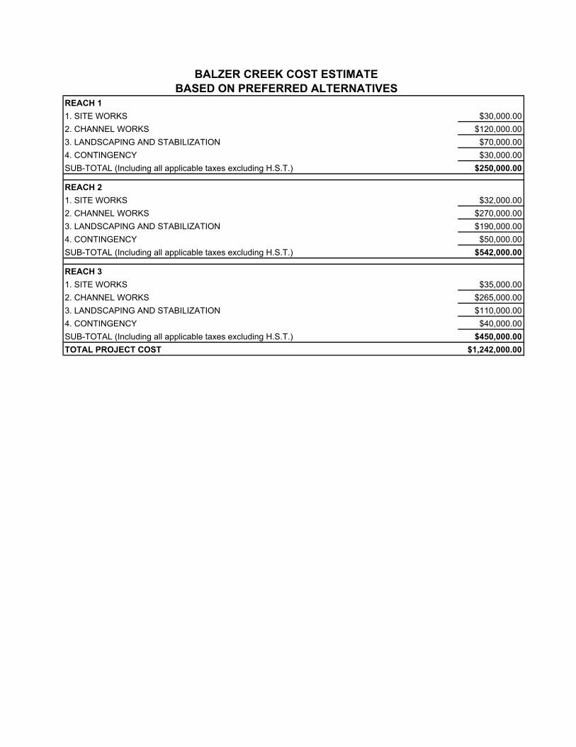
REACH 11. SITE WORKS $30,000.002. CHANNEL WORKS $120,000.003. LANDSCAPING AND STABILIZATION $70,000.004. CONTINGENCY $30,000.00SUB-TOTAL (Including all applicable taxes excluding H.S.T.) $250,000.00
REACH 21. SITE WORKS $32,000.002. CHANNEL WORKS $270,000.003. LANDSCAPING AND STABILIZATION $190,000.004. CONTINGENCY $50,000.00SUB-TOTAL (Including all applicable taxes excluding H.S.T.) $542,000.00
REACH 31. SITE WORKS $35,000.002. CHANNEL WORKS $265,000.003. LANDSCAPING AND STABILIZATION $110,000.004. CONTINGENCY $40,000.00SUB-TOTAL (Including all applicable taxes excluding H.S.T.) $450,000.00TOTAL PROJECT COST $1,242,000.00
BALZER CREEK COST ESTIMATE BASED ON PREFERRED ALTERNATIVES