Embed Size (px)
Citation preview
Stage 1 Archaeological Assessment for the: Proposed Sub-Trunk #1 Sanitary Sewer Class EA
Within Part of Lots 1-7, Concession 10 Historic Township of Whitchurch
And Lot 35, Concession 10 Historic Township of Markham Town of Whitchurch-Stouffville
Regional Municipality of York Ontario
Project #: 070-WS849-12 Licensee (#): Kim Slocki (P029)
PIF#: P029-832-2012
Original Report
February 28th, 2013
Presented to: Chisholm, Fleming and Associates
317 Renfrew Drive, Suite #301 Markham, Ontario
L3R 9S8 T: 905.474.1458 F: 905.474.1910
Prepared by:
Archeoworks Inc. 16715-12 Yonge Street, Suite #1029
Newmarket, Ontario L3X 1X4
T: 416.676.5597 F: 416.676.5810
AR
CH
EOW
OR
KS
INC
.
ARCHEOWORKS INC. i
Stage 1 AA for the Proposed Sub-Trunk #1 Sanitary Sewer Class EA, Town of Whitchurch-Stouffville, Regional Municipality of York, Ontario
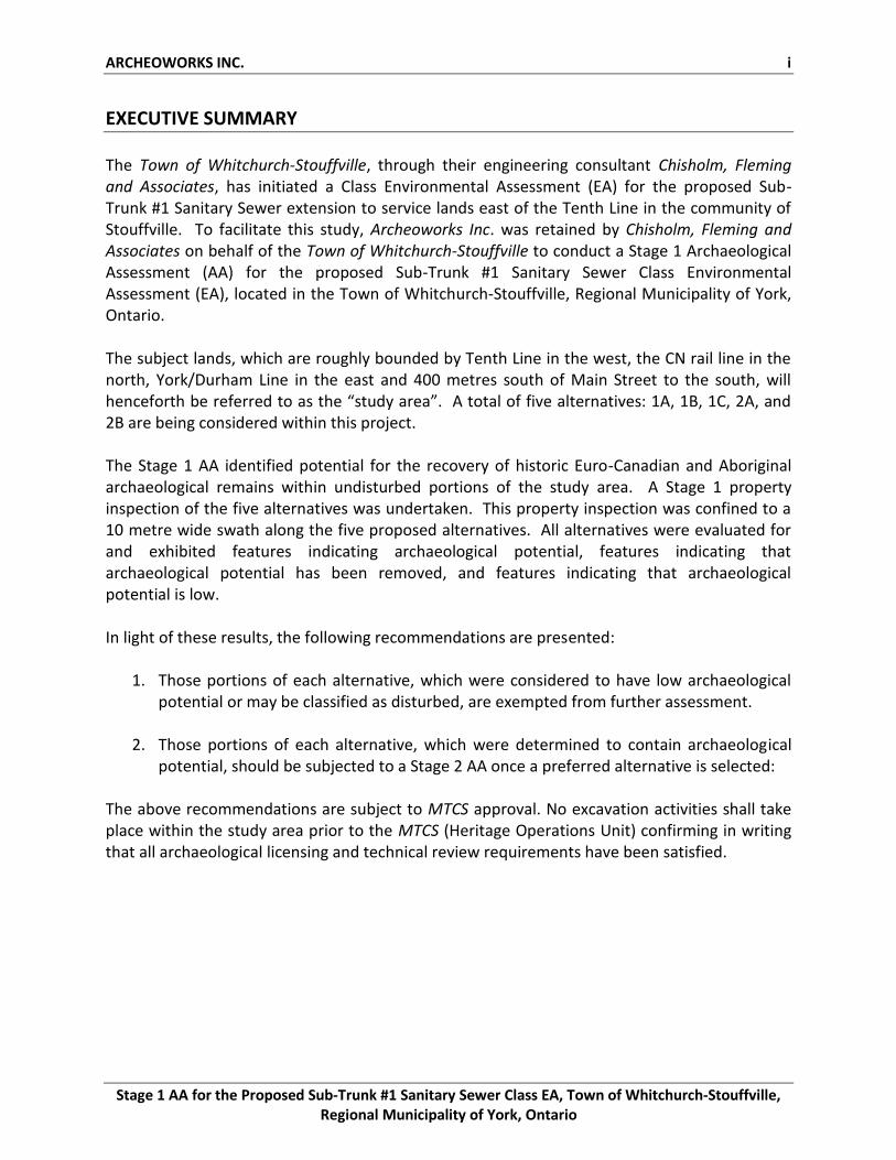
EXECUTIVE SUMMARY
The Town of Whitchurch-Stouffville, through their engineering consultant Chisholm, Fleming and Associates, has initiated a Class Environmental Assessment (EA) for the proposed Sub-Trunk #1 Sanitary Sewer extension to service lands east of the Tenth Line in the community of Stouffville. To facilitate this study, Archeoworks Inc. was retained by Chisholm, Fleming and Associates on behalf of the Town of Whitchurch-Stouffville to conduct a Stage 1 Archaeological Assessment (AA) for the proposed Sub-Trunk #1 Sanitary Sewer Class Environmental Assessment (EA), located in the Town of Whitchurch-Stouffville, Regional Municipality of York, Ontario. The subject lands, which are roughly bounded by Tenth Line in the west, the CN rail line in the north, York/Durham Line in the east and 400 metres south of Main Street to the south, will henceforth be referred to as the “study area”. A total of five alternatives: 1A, 1B, 1C, 2A, and 2B are being considered within this project. The Stage 1 AA identified potential for the recovery of historic Euro-Canadian and Aboriginal archaeological remains within undisturbed portions of the study area. A Stage 1 property inspection of the five alternatives was undertaken. This property inspection was confined to a 10 metre wide swath along the five proposed alternatives. All alternatives were evaluated for and exhibited features indicating archaeological potential, features indicating that archaeological potential has been removed, and features indicating that archaeological potential is low. In light of these results, the following recommendations are presented:
1. Those portions of each alternative, which were considered to have low archaeological potential or may be classified as disturbed, are exempted from further assessment.
2. Those portions of each alternative, which were determined to contain archaeological potential, should be subjected to a Stage 2 AA once a preferred alternative is selected:
The above recommendations are subject to MTCS approval. No excavation activities shall take place within the study area prior to the MTCS (Heritage Operations Unit) confirming in writing that all archaeological licensing and technical review requirements have been satisfied.

ARCHEOWORKS INC. ii
Stage 1 AA for the Proposed Sub-Trunk #1 Sanitary Sewer Class EA, Town of Whitchurch-Stouffville, Regional Municipality of York, Ontario
TABLE OF CONTENTS
Executive Summary ...........................................................................................................................i Table of Contents ............................................................................................................................. ii Project Personnel ............................................................................................................................ iii 1.0 Project Context .................................................................................................................... 1-13
1.1 Development Context ....................................................................................................... 1 1.2 Historical Context ........................................................................................................... 1-9 1.3 Archaeological Context ................................................................................................. 9-13 1.4 Confirmation of Archaeological Potential ....................................................................... 13
2.0 Field Methods .................................................................................................................... 13-14 3.0 Analysis and Conclusions ................................................................................................... 14-16
3.1 Alternative 1A .................................................................................................................. 14 3.2 Alternative 1B .................................................................................................................. 14 3.3 Alternative 1C .................................................................................................................. 15 3.4 Alternative 2A .................................................................................................................. 15 3.5 Alternative 2B ............................................................................................................. 15-16
4.0 Recommendations .................................................................................................................. 16 5.0 Advice on Compliance with Legislation ............................................................................. 16-17 6.0 Bibliography and Sources ................................................................................................... 18-21 Tables Table 1: Historic Structures within the Stage 1 AA Study Area ................................................... 6-7 Table 2: Listed Heritage Properties within the Study Area ............................................................ 8 Table 3: Listed Heritage Properties adjacent to (within 300m of) the Study Area ..................... 8-9 Table 4: Sites within One Kilometre of the Study Area ................................................................ 10 Table 5: History of Occupation in Southern Ontario ............................................................... 10-11
Appendices Appendix A: Maps .................................................................................................................... 22-29 Appendix B: Confirmation of Archaeological Potential ................................................................ 30 Appendix C: Images .................................................................................................................. 31-34 Appendix D: Inventory of Documentary and Material Record ..................................................... 35
ARCHEOWORKS INC. iii
Stage 1 AA for the Proposed Sub-Trunk #1 Sanitary Sewer Class EA, Town of Whitchurch-Stouffville, Regional Municipality of York, Ontario
PROJECT PERSONNEL Project Director ............................................................................... Kim Slocki – MTCS licence P029 Review Archaeologist .............................................................. Lee Templeton – MTCS licence R454 Report Preparation ..................................................................... Jessica Marr – MTCS licence P334
Nimal Nithiyanantham – MTCS licence R311 Historical Research.................................................................. Lee Templeton - MTCS licence R454 Report Review ................................................................................. Kim Slocki – MTCS licence P029 Graphics ....................................................................................................................... Mike Lawson
Jessica Marr – MTCS licence P334 Nimal Nithiyanantham – MTCS licence R311
Lee Templeton – MTCS licence R454
ARCHEOWORKS INC 1
Stage 1 AA for the Proposed Sub-Trunk #1 Sanitary Sewer Class EA, Town of Whitchurch-Stouffville, Regional Municipality of York, Ontario
1.0 PROJECT CONTEXT
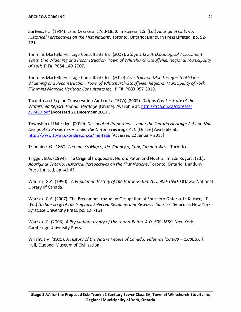
1.1 Development Context The Town of Whitchurch-Stouffville, through their engineering consultant Chisholm, Fleming and Associates, has initiated a Class Environmental Assessment (EA) for the proposed Sub-Trunk #1 Sanitary Sewer extension to service lands east of the Tenth Line in the community of Stouffville. This project is planned as a Schedule ‘B’ project as outlined in the Municipal Engineer’s Association (MEA) Municipal Class EA (October 2000, as amended in 2007 & 2011), which is an approved process under the EA Act. To facilitate this study, Archeoworks Inc. was retained by Chisholm, Fleming and Associates on behalf of the Town of Whitchurch-Stouffville to conduct a Stage 1 Archaeological Assessment (AA) for the proposed Sub-Trunk #1 Sanitary Sewer Class Environmental Assessment (EA), located in the Town of Whitchurch-Stouffville, Regional Municipality of York, Ontario. The subject lands, which are roughly bounded by Tenth Line in the west, the CN rail line in the north, York/Durham Line in the east and 400 metres south of Main Street to the south, will henceforth be referred to as the “study area” (see Appendix A – Map 1). A total of five alternatives: 1A, 1B, 1C, 2A, and 2B are being considered for this project (see Map 2). This Stage 1 AA was conducted pre-submission under the project direction of Ms. Kim Slocki, under archaeological consulting licence P029, in accordance with the Ontario Heritage Act (2009) and the Ontario EA Act (2010). Permission to review and assess the archaeological potential of the study area was provided by Chisholm, Fleming and Associates on November 23rd, 2012.
1.2 Historical Context The 2011 Standards and Guidelines for Consultant Archaeologists (‘2011 S&G’), published by the Ministry of Tourism, Culture and Sport (MTCS) considers the following features or characteristics to be indicative of archaeological potential: previously identified archaeological sites; water sources (i.e., primary water sources, secondary water sources, features indicating past water sources; accessible or inaccessible shoreline); elevated topography; pockets of well-drained sandy soil, especially near areas of heavy soil or rocky ground; distinctive land formations; and resource areas (i.e., food or medicinal plant; scarce raw material; and early Euro-Canadian industry). Additionally, 2011 S&G considers areas of early Euro-Canadian settlement, including places of early military pioneer or pioneer settlement (e.g., pioneer homesteads, isolated cabins, and farmstead complexes), early wharf or dock complexes, and pioneer churches and early cemeteries, as having archaeological potential. There may be commemorative markers of their history, such as local, provincial, or federal monuments or heritage parks. Early historical transportation routes (trails, passes, roads, railways, portage routes), properties listed in a municipal register or designated under the Ontario Heritage Act
ARCHEOWORKS INC 2
Stage 1 AA for the Proposed Sub-Trunk #1 Sanitary Sewer Class EA, Town of Whitchurch-Stouffville, Regional Municipality of York, Ontario
or a federal, provincial, or municipal historic landmark or site, and properties that local histories or informants have identified with possible archaeological sites, historical events, activities, or occupations are also considered to have archaeological potential. To establish the archaeological significance of the study corridor, a comprehensive review of listed and designated heritage properties, and registered archaeological sites within close proximity to its limits was undertaken. Furthermore, a review of the physiography of the overall area and its correlation to locating archaeological remains, as well as consultation of available historical documentation was performed. The results of this background research are documented below and summarized in Appendix B. 1.2.1 Pre-Contact Period The region where the study area is situated was first inhabited after the southeast retreat of the Simcoe Lobe and the Ontario Lobe of the North American Laurentide ice sheet approximately 12,000 years ago. As the ice sheet retreated, a crack formed between the two lobes while torrential flood channels beneath the ice deposited large amounts of incongruous sediments into this crack, forming the unconformable strata of the Oak Ridges Moraine (Barnett et al., 1998, p.1154). Four prominent wedges formed within the Oak Ridges Moraine, such as the Uxbridge wedge, as a consequence of deltaic and glaciofluvial sediments that were deposited in expanded glacial lake basins between the receding ice margins and existing moraine sediments (Barnett et al., 1998, p.1162). Glacial meltwater began to erode the terrain forming streams and rivers, such as Reesor Creek in the Duffins Creek watershed, which flows from its headwaters at the Oak Ridges Moraine into Lake Ontario. Initial vegetation within the Oak Ridges Moraine was tundra-like and developed into pine jack and red pine forests which favoured the numerous morainic ridges (Karrow and Warner, 1990). As the climate steadily warmed, small groups of Paleo-Indians entered Southern Ontario. Paleo-Indians consisted of small groups of nomadic hunter-gathers who depended on “naturally” available foodstuff such as game or wild plants (Ellis and Deller, 1990). Sites in Southern Ontario appear to be small campsites commonly associated with glacial features such as glacial lake shorelines; however, as water levels were considerably lower than present, it is likely many Paleo- sites are now underwater (Bursey 2013a; Ellis and Deller, 1990). The artifact assemblage from this period is characterized by fluted and lanceolate stone points, scrapers and small projectile points produced from specific chert types (Ellis and Deller, 1990). These items were created and transported over great distances as a result of following migratory animals within a massive territory.
By 9,000 years ago, the extensive mast forest environment of the South Slope, with their greater densities of deer and certain other resources, permitted a more dispersed seasonal settlement pattern (Wright, 1995). Additionally, Archaic Aboriginals exploited as they continued to hunt large game in small bands during summer months and returned to their family groups by the winter (Bursey et al., 2013b). House structures were moveable and the size of these small villages gradually grew in size as population numbers increased. The artifact assemblages
ARCHEOWORKS INC 3
Stage 1 AA for the Proposed Sub-Trunk #1 Sanitary Sewer Class EA, Town of Whitchurch-Stouffville, Regional Municipality of York, Ontario
from this period can be characterized by the presence of wood-working implements such as groundstone axes, adzes, gouges and net-sinkers; the presence of native copper mined from the Lake Superior region, indicative of long-range exchange and interaction with other Aboriginal groups; and stone tools of local chert types that demonstrate improved technical skills (Ellis et al, 1990; TRCA, 2002). Approximately 3,000 years ago the Woodland period began, marked by the increased reliance on domesticated plants, the utilization of both hunting and gathering to procure a larger variety of foods, and the introduction of pottery indicative of a successful subsistence pattern that would require long-term storage of abundant resources. Furthermore, grave goods gradually became more exotic and frequent, indicative of the growing complexity and trade networks between Great Lakes communities. During the Woodland period, the distinct cultural groups of the post-contact period had begun to develop (Bursey et al, 2013c).
Beginning in 900 A.D until the late 13th century, the Ontario Iroquoian Tradition flourished throughout much of Western and Central Ontario. The Iroquoian Tradition refers to a cultural pattern and a linguistic family in North America which includes the Huron (Wendat), Neutral (called Attiewandaron by the Wendat), Petun (Tionnontaté) in Ontario and the Five Nations of the Iroquois (Haudenosaunee) of Upper State New York (Birch, 2010). Each group had their distinctive traits but shared in a similar pattern of life. Villages developed as horticulture began to take on a more central importance in subsistence patterns, particularly the farming of maize, squash and beans, supplemented by fishing, hunting and gathering. Each village was comprised of numerous multi-family longhouses whose residence was determined on matrilineal descent (Kapches, 2007). The longhouses were compacted within a defensive palisade that overlooked cultivated fields of corn, squash and beans. Most Iroquoian sites were occupied for 10-50 years with minimal reoccupation of the same site (Warrick, 2007, p.127). The village was often located near primary and secondary waterways to optimize its economic and trading capabilities. Intertribal trade consisted of small luxury items that could be carried overland (Trigger, 1994). 1.2.2 Contact Period In 1615, at the time of first contact with the French, the Wendat population was reported to be approximately 30,000 individuals whose territorial homeland roughly stretches between the Canadian Shield, Lake Ontario and the Niagara Escarpment, known as Wendake (Warrick, 2008). It is speculated that four tribes; the Attignawantan, Tahontaenrat, Attigneenongnahac, and Arendahronon, amalgamated to form a single confederacy, the Wendat Confederacy in defense against the continual aggression of the Haudenosaunee (Warrick, 2008). The Arendahronon of the Huron Confederacy became interested in establishing a direct trading relationship with the French to obtain European goods in larger quantities and at cheaper prices (Trigger 1994: p.47). For the French, this opened new pelt territory and ensured greater quantities of furs would be available for trade. The Wendat were present in the vicinity of the Town of Whitchurch-Stouffville, specifically at the Mantle Site, an early 16th century Wendat Village located along the Stouffville Creek and
ARCHEOWORKS INC 4
Stage 1 AA for the Proposed Sub-Trunk #1 Sanitary Sewer Class EA, Town of Whitchurch-Stouffville, Regional Municipality of York, Ontario
adjacent to (within 300m of) study area. This site appears to have been an amalgamation of people from different villages who joined together in the late 15th century for defensive purposes. This site sprawled over nine acres and is surrounded by eight rows of palisade representing various rebuilding sequences, over 95 longhouses, numerous artifact-rich midden deposits and over 1000 pit features producing over 18,000 artifacts. At its peak, the Mantle Site likely housed over 2000 individuals, who focused on maize cultivation, representing about 50% of their diet. After generations, the site was abandoned as a result of declining soil fertility, deforestation, and depletion of wild game. The community relocated to form one of the Huron tribes in the Orillia-Georgian Bay area (Archaeological Services Inc., 2013). During the 1630s, Jesuit missionaries attempted to convert the entire Wendat Confederacy to Christianity; however, the Jesuits’ presence in the region had become precarious after a series of major epidemics of European diseases killed nearly 60% of the Wendat population (Warrick, 1990; Warrick 2008). By 1645, having grown dependent on European goods and with their territory no longer yielding enough animal pelts, the Haudenosaunee became increasingly aggressive towards the Wendat Confederacy. Armed with the guns and ammunition from the Dutch, the Haudenosaunee engaged in brutal warfare with the Wendat Confederacy and brutally attacked and destroyed several Wendat villages throughout Southern Ontario (Trigger, 1994). The small groups that remained of the Wendat Confederacy became widely dispersed throughout the Great Lakes region. As early as 1653, the Anishinaabe, of the Algonquin-speaking linguistic group, wanted control of the land between Lake Huron and Lake Ontario in order to further their role in the fur trade (Johnston, 2004). After a major smallpox epidemic in 1662, the capture of New Netherland by the English in 1664 curtain tailing access to guns and powder, and a series of French military expeditions against the Haudenosaunee in 1665 forced the Haudenosaunee to sue for peace (Warrick, 2008, p.242). In 1701, representatives of several Anishinaabe Nations and the Haudenosaunee assembled in Montreal to participate in Great Peace negotiations, sponsored by the French (Johnston, 2004). These two groups remained peaceful well into the 18th century. 1.2.3 Settlement History By the end of the 1700s, a small tribe within the Anishinaabe Nation, the Mississauga, claimed portions of what is now York County. The Mississaugas’ settlement was focused around seasonal resources; they were hunter-gatherers with a minimal focus on horticulture. The Mississaugas simultaneously traded with the French and British while they engaged in the Seven Years’ War, and remained peaceful during the Pontiac War. After the American War of Independence in the late 1700s, a large number of United Empire Loyalists and American immigrants began to move into Southern Ontario, putting greater demand on the quantity of available lands for settlement within York County. In 1787, senior officials from the Indian Department met with the Mississaugas of the Carrying Place to acquire land along the northern shores of Lake Ontario extending northward to Lake Simcoe (Surtees,
ARCHEOWORKS INC 5
Stage 1 AA for the Proposed Sub-Trunk #1 Sanitary Sewer Class EA, Town of Whitchurch-Stouffville, Regional Municipality of York, Ontario
1994, p.107). Due to irregularities in the 1878 treaty, William Claus, the Deputy Superintendent of Indian Affairs, entered into negotiations with the Mississaugas in 1805 to redefine the original northern boundaries and to purchase a greater tract of land in order to accommodate the influx of American and European settlers. The crown purchased 250,800 acres of land, which included York County, for 1,000 pounds of Quebec currency worth of goods (Natural Resources Canada, 2003). However, the matter of land cession within York County remained dormant until 1923 when the land was formally bought by the Crown during the William’s Treaty. Due to the consistent American threat, Lieutenant-Governor John Graves Simcoe saw the necessity of constructing a road north from the Town of York to Holland Landing in order to provide a military road to the fort at Penetanguishene, should the Americans provoke war. Completed in 1796, Yonge Street utilized known ancient native trails east of the Carrying Place Trail by way of Bond Lake and branches of the Don River (Neilson, 2012). Briefly used as a military road, its ultimate function was to define the land boundaries of the northern townships of York County. The Township of Whitchurch was surveyed by Surveyor John Stegmann in 1800 and completed in 1802 and the Township of Markham was surveyed by Abraham Iredell in 1793-1794 (Miles & Co., 1878). Both surveys utilized the single-front system, the common survey method used from 1783 to 1818 (Harris and Warkentin, 2000). Long and thin lots were superimposed on an artificial grid equaling 200 acres in size, and were arranged in single tiers between concession-line roads resembling the single-rang system in Quebec (Harris and Warkentin, 2000). The earliest settlers to Whitchurch came from varied backgrounds: Quakers from Pennsylvania escaping religious persecution; Hessian soldiers gaining land for their participation on behalf of the British during the American War of Independence; and Mennonites (Barkley, 1993, p.14). The majority of settlers who resided to the north of the township, beyond the Oak Ridges Moraine, were Mennonites and Tunkers; German and Dutch settlers who hold the same views as Quakers in relation to wars and oaths (Mulvany and Adam, 1885, p.148). Timothy Rogers, a Quaker from Vermont, lead forty Quaker (Society of Friends) families to Whitchurch to help establish a viable community to encourage later settlement (Barkley, 1993). Having received one thousand acres from the Upper Canadian government, Timothy arranged and received land patents to help settle Quaker immigrants in Whitchurch and several small Quaker hamlets formed. These settlers rapidly transformed their large land tracts from a state of nature to a condition of high cultivation resulting from their inherited experience brought with them from Vermont, Pennsylvania and New York (Scadding, 1873, p.476). The earliest settlers to Markham Township were United Empire Loyalist, French emigrés and most notably, German Mennonites lead by William von Moll Berczy, a man of indomitable energy and boundless resource (Mulvany and Adam, 1885, p.115). In 1794, William Berczy, brought over from the Pulteney Settlement, on the south side of Lake Ontario, sixty German families, and conducted them to the township of Markham, where lands had been assigned to them (Scadding, 1873, p.414). At the same time, to navigate a route to the southern part of Township of Markham, Berczy cut a way through the forest along the line marked out for Yonge
ARCHEOWORKS INC 6
Stage 1 AA for the Proposed Sub-Trunk #1 Sanitary Sewer Class EA, Town of Whitchurch-Stouffville, Regional Municipality of York, Ontario
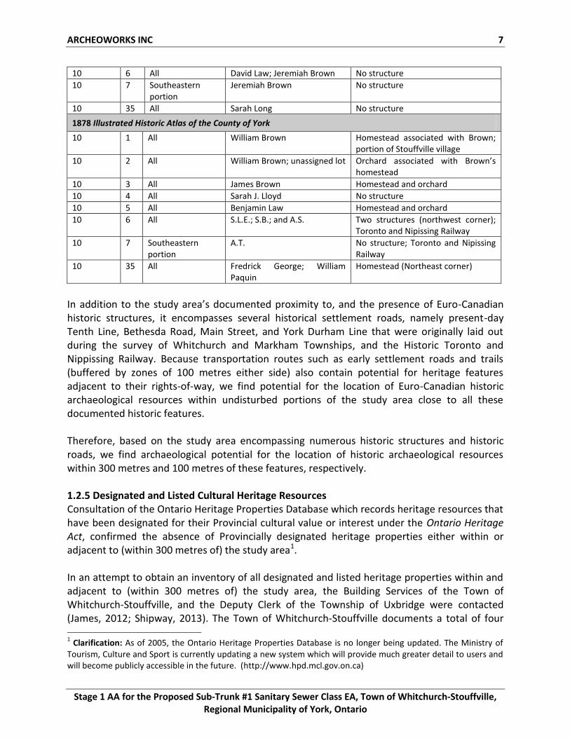
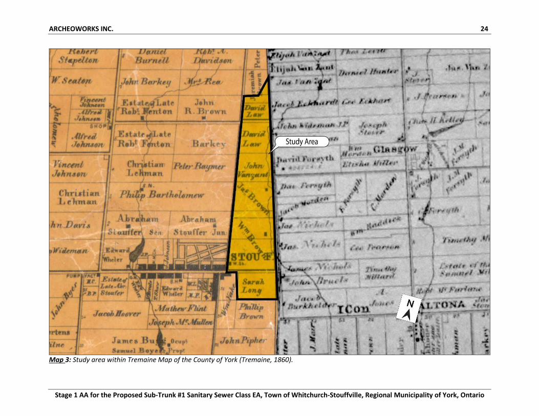
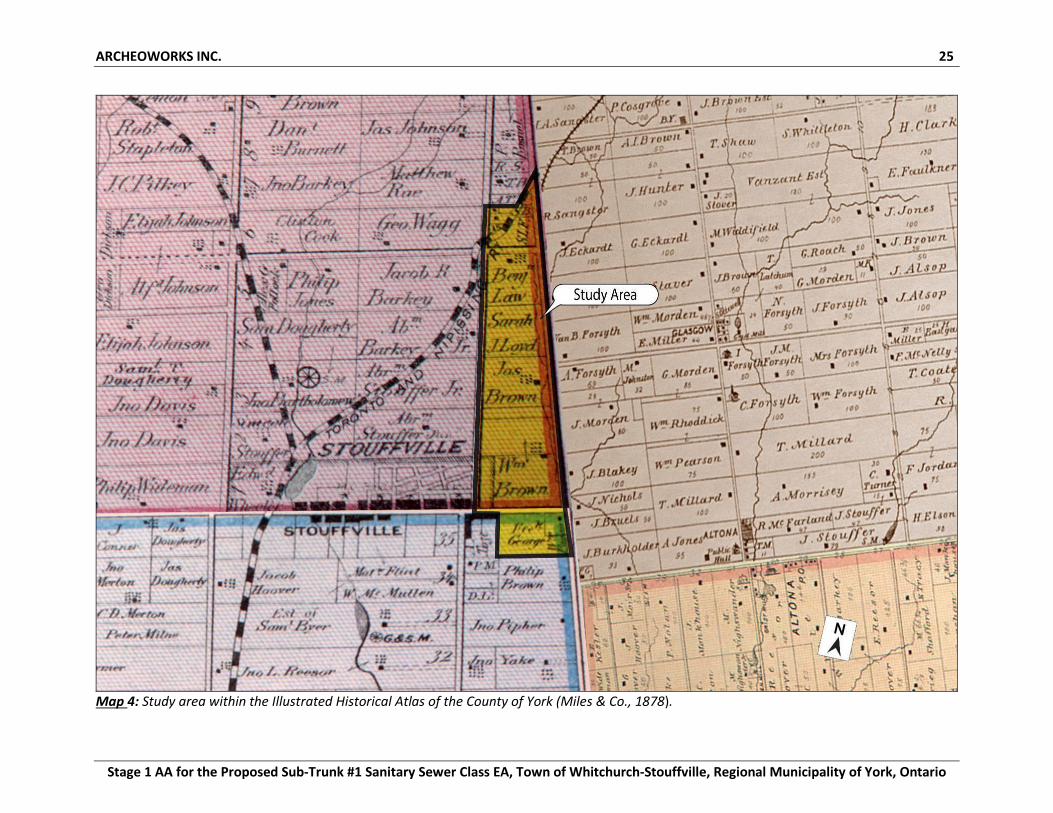
Street (Miles & Co., 1878). These earliest settlers focused their settlement around waterways, establishing the first grist and saw mills along the southern boundaries of the township and along the Rouge River, effectively laying the foundations of the prosperous community (Miles & Co., 1878). After the land was cleared of overgrowth vegetation, pioneers focused on agriculture as their primary form of subsistence, and by 1850 the Township of Markham contained 6868 inhabitants, had thirteen grist, and 27 saw mills (Smith, 1851, p.42). The town of Whitchurch-Stouffville was founded with the arrival of Abraham Stouffer, a Pennsylvanian miller whose family was originally from Switzerland. Stouffer, in the fall of 1804, traveled from Pennsylvania and settled on 600 acres at Main and Mill Streets on the Markham-Stouffville town line (Barkley, 1993). There he built several saw and grist mills between 1817 and 1824 (Barkley, 1993). By 1851, Stouffville was a road village, centred along one road instead of around an intersection, and with two taverns, a lumber mill, cabinet maker, wagon maker, marble works, saw and grist mill, and a harness shop were the main industries in the hamlet (Barkley, 1993). In 1871, the Toronto and Nippissing Railway opened through Stouffville and although the community expected increased economic activity after its construction, such events did not happen for nearly ten years when a spur-line, the Lake Simcoe Junction Railway, was built from Stouffville to Lake Simcoe in 1877 (Barkley, 1993). Several more industries and hotels were constructed in the late 1870s to accommodate this population influx and Stouffville became an incorporated village in 1877 (Mulvany and Adams, 1885). The village population continued to grow and by 1901, increased to 1,223 individuals. In 1971, Stouffville united with part of Whitchurch Township, forming the Town of Whitchurch-Stouffville (Barkley, 1993). 1.2.4 Past Land Use of Study Area To assess the study area’s potential for the recovery of historic pre-1900 remains, several documents were reviewed, namely the 1860 Tremaine’s Map of the County of York and the 1878 Illustrated Historical Atlas of the County of York (see Maps 3-4; Table 1). The study area encompasses Lots 1-7, Concession 10, in the Historic Township of Whitchurch, and Lot 35, Concession 10, in the Historic Township of Markham, County of York. In 1860, three historic structures are illustrated within the study area, while the majority of the study area was being employed for agricultural purposes. Additionally, Reesor Creek, a primary water source, is illustrated traversing the study area. By 1878, six historic structures are illustrated within the study area, as well as the eastern extent of the village of Stouffville, and the Toronto and Nipissing Railway bisects the northern portion of the study area. Table 1: Historical Structures within the Stage 1 AA Study Area
1860 Tremaine’s Map of the County of York
Concession Lot Portion Occupant/Owner Structure(s)
10 1 All William Brown Wagon Shop
10 2 All William Brown; unassigned lot Homestead
10 3 All James Brown Homestead
10 4 All John Vanzant No structure
10 5 All David Law No structure
ARCHEOWORKS INC 7
Stage 1 AA for the Proposed Sub-Trunk #1 Sanitary Sewer Class EA, Town of Whitchurch-Stouffville, Regional Municipality of York, Ontario
10 6 All David Law; Jeremiah Brown No structure
10 7 Southeastern portion
Jeremiah Brown No structure
10 35 All Sarah Long No structure
1878 Illustrated Historic Atlas of the County of York
10 1 All William Brown Homestead associated with Brown; portion of Stouffville village
10 2 All William Brown; unassigned lot Orchard associated with Brown’s homestead
10 3 All James Brown Homestead and orchard
10 4 All Sarah J. Lloyd No structure
10 5 All Benjamin Law Homestead and orchard
10 6 All S.L.E.; S.B.; and A.S. Two structures (northwest corner); Toronto and Nipissing Railway
10 7 Southeastern portion
A.T. No structure; Toronto and Nipissing Railway
10 35 All Fredrick George; William Paquin
Homestead (Northeast corner)
In addition to the study area’s documented proximity to, and the presence of Euro-Canadian historic structures, it encompasses several historical settlement roads, namely present-day Tenth Line, Bethesda Road, Main Street, and York Durham Line that were originally laid out during the survey of Whitchurch and Markham Townships, and the Historic Toronto and Nippissing Railway. Because transportation routes such as early settlement roads and trails (buffered by zones of 100 metres either side) also contain potential for heritage features adjacent to their rights-of-way, we find potential for the location of Euro-Canadian historic archaeological resources within undisturbed portions of the study area close to all these documented historic features. Therefore, based on the study area encompassing numerous historic structures and historic roads, we find archaeological potential for the location of historic archaeological resources within 300 metres and 100 metres of these features, respectively. 1.2.5 Designated and Listed Cultural Heritage Resources Consultation of the Ontario Heritage Properties Database which records heritage resources that have been designated for their Provincial cultural value or interest under the Ontario Heritage Act, confirmed the absence of Provincially designated heritage properties either within or adjacent to (within 300 metres of) the study area1. In an attempt to obtain an inventory of all designated and listed heritage properties within and adjacent to (within 300 metres of) the study area, the Building Services of the Town of Whitchurch-Stouffville, and the Deputy Clerk of the Township of Uxbridge were contacted (James, 2012; Shipway, 2013). The Town of Whitchurch-Stouffville documents a total of four 1 Clarification: As of 2005, the Ontario Heritage Properties Database is no longer being updated. The Ministry of
Tourism, Culture and Sport is currently updating a new system which will provide much greater detail to users and will become publicly accessible in the future. (http://www.hpd.mcl.gov.on.ca)
ARCHEOWORKS INC 8
Stage 1 AA for the Proposed Sub-Trunk #1 Sanitary Sewer Class EA, Town of Whitchurch-Stouffville, Regional Municipality of York, Ontario
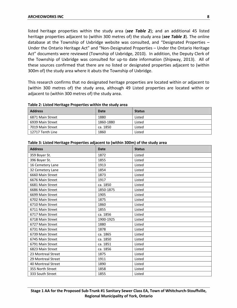
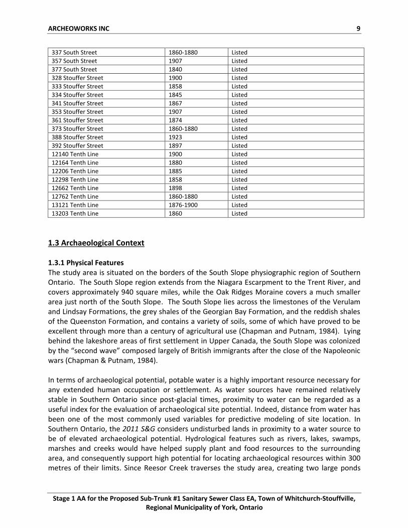
listed heritage properties within the study area (see Table 2); and an additional 45 listed heritage properties adjacent to (within 300 metres of) the study area (see Table 3). The online database at the Township of Uxbridge website was consulted, and “Designated Properties – Under the Ontario Heritage Act” and “Non-Designated Properties – Under the Ontario Heritage Act” documents were reviewed (Township of Uxbridge, 2010). In addition, the Deputy Clerk of the Township of Uxbridge was consulted for up-to date information (Shipway, 2013). All of these sources confirmed that there are no listed or designated properties adjacent to (within 300m of) the study area where it abuts the Township of Uxbridge. This research confirms that no designated heritage properties are located within or adjacent to (within 300 metres of) the study area, although 49 Listed properties are located within or adjacent to (within 300 metres of) the study area. Table 2: Listed Heritage Properties within the study area
Address Date Status
6871 Main Street 1880 Listed
6939 Main Street 1860-1880 Listed
7019 Main Street ca. 1850 Listed
12717 Tenth Line 1860 Listed
Table 3: Listed Heritage Properties adjacent to (within 300m) of the study area
Address Date Status
359 Boyer St. 1872 Listed
396 Boyer St. 1855 Listed
16 Cemetery Lane 1913 Listed
32 Cemetery Lane 1854 Listed
6660 Main Street 1873 Listed
6676 Main Street 1917 Listed
6681 Main Street ca. 1850 Listed
6686 Main Street 1850-1875 Listed
6699 Main Street 1905 Listed
6702 Main Street 1875 Listed
6710 Main Street 1860 Listed
6711 Main Street 1855 Listed
6717 Main Street ca. 1856 Listed
6718 Main Street 1900-1925 Listed
6727 Main Street 1880 Listed
6731 Main Street 1878 Listed
6739 Main Street ca. 1865 Listed
6745 Main Street ca. 1850 Listed
6791 Main Street ca. 1851 Listed
6823 Main Street ca. 1856 Listed
23 Montreal Street 1875 Listed
29 Montreal Street 1911 Listed
40 Montreal Street 1890 Listed
355 North Street 1858 Listed
333 South Street 1855 Listed
ARCHEOWORKS INC 9
Stage 1 AA for the Proposed Sub-Trunk #1 Sanitary Sewer Class EA, Town of Whitchurch-Stouffville, Regional Municipality of York, Ontario
337 South Street 1860-1880 Listed
357 South Street 1907 Listed
377 South Street 1840 Listed
328 Stouffer Street 1900 Listed
333 Stouffer Street 1858 Listed
334 Stouffer Street 1845 Listed
341 Stouffer Street 1867 Listed
353 Stouffer Street 1907 Listed
361 Stouffer Street 1874 Listed
373 Stouffer Street 1860-1880 Listed
388 Stouffer Street 1923 Listed
392 Stouffer Street 1897 Listed
12140 Tenth Line 1900 Listed
12164 Tenth Line 1880 Listed
12206 Tenth Line 1885 Listed
12298 Tenth Line 1858 Listed
12662 Tenth Line 1898 Listed
12762 Tenth Line 1860-1880 Listed
13121 Tenth Line 1876-1900 Listed
13203 Tenth Line 1860 Listed
1.3 Archaeological Context 1.3.1 Physical Features The study area is situated on the borders of the South Slope physiographic region of Southern Ontario. The South Slope region extends from the Niagara Escarpment to the Trent River, and covers approximately 940 square miles, while the Oak Ridges Moraine covers a much smaller area just north of the South Slope. The South Slope lies across the limestones of the Verulam and Lindsay Formations, the grey shales of the Georgian Bay Formation, and the reddish shales of the Queenston Formation, and contains a variety of soils, some of which have proved to be excellent through more than a century of agricultural use (Chapman and Putnam, 1984). Lying behind the lakeshore areas of first settlement in Upper Canada, the South Slope was colonized by the “second wave” composed largely of British immigrants after the close of the Napoleonic wars (Chapman & Putnam, 1984). In terms of archaeological potential, potable water is a highly important resource necessary for any extended human occupation or settlement. As water sources have remained relatively stable in Southern Ontario since post-glacial times, proximity to water can be regarded as a useful index for the evaluation of archaeological site potential. Indeed, distance from water has been one of the most commonly used variables for predictive modeling of site location. In Southern Ontario, the 2011 S&G considers undisturbed lands in proximity to a water source to be of elevated archaeological potential. Hydrological features such as rivers, lakes, swamps, marshes and creeks would have helped supply plant and food resources to the surrounding area, and consequently support high potential for locating archaeological resources within 300 metres of their limits. Since Reesor Creek traverses the study area, creating two large ponds
ARCHEOWORKS INC 10
Stage 1 AA for the Proposed Sub-Trunk #1 Sanitary Sewer Class EA, Town of Whitchurch-Stouffville, Regional Municipality of York, Ontario
within its limits, there is potential to locate archaeological resources within the study area limits, within 300 metres of this water resource (see Appendix B). 1.3.2 Current Land Condition and Uses The study area is situated within a mixed landscape, and lies partly within the Town of Whitchurch-Stouffville. Land uses within the study area can be categorized as rural-agricultural, commercial and residential (see Appendix D – Images 1-10). The topography in the study area slopes to the south, with elevations ranging from 310 metres in the northern part of the study area to 274 metres in the southern part of the study area. The native soils are Woburn loam, Milliken loam, Monoghan clay loam, and Bottom Land. Woburn loam is a grey-brown podzolic soil that is stone free with good drainage, Milliken loam and Monaghan clay-loam are both grey-brown podzolic soils with imperfect drainage and few stones, differing mainly in acidity, and Bottom Land is an alluvian soil with variable drainage (Experimental Farms Service, 1945).
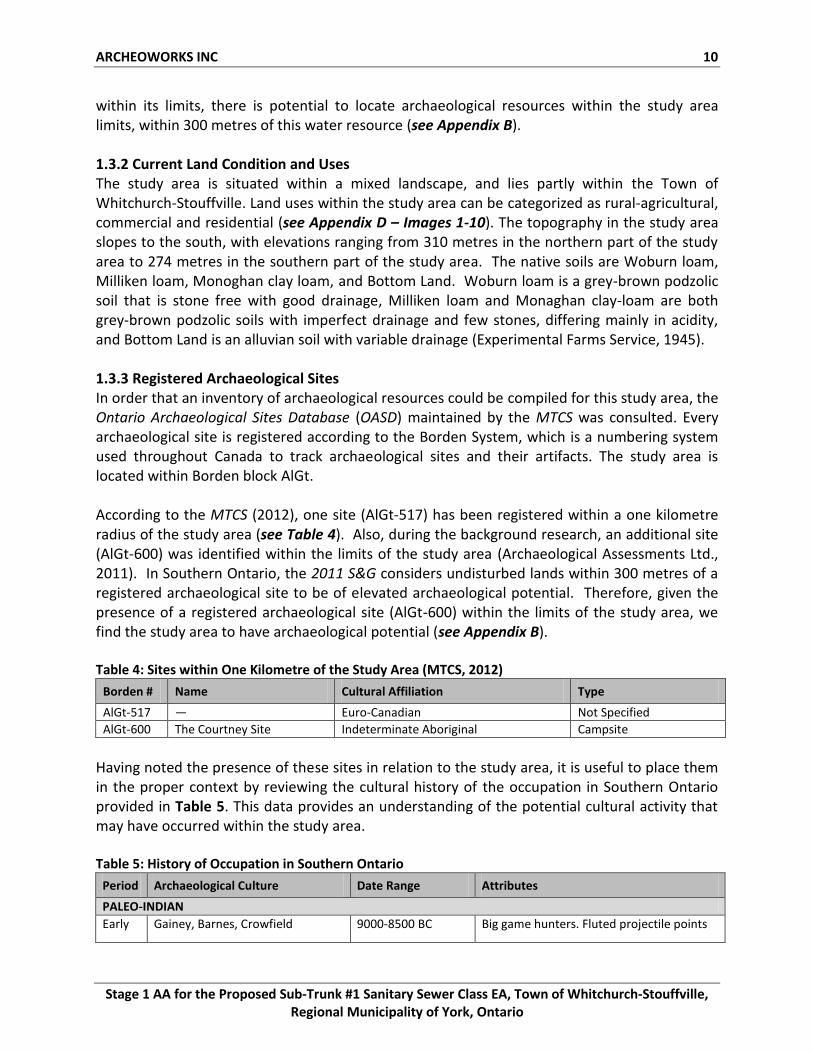
1.3.3 Registered Archaeological Sites In order that an inventory of archaeological resources could be compiled for this study area, the Ontario Archaeological Sites Database (OASD) maintained by the MTCS was consulted. Every archaeological site is registered according to the Borden System, which is a numbering system used throughout Canada to track archaeological sites and their artifacts. The study area is located within Borden block AlGt. According to the MTCS (2012), one site (AlGt-517) has been registered within a one kilometre radius of the study area (see Table 4). Also, during the background research, an additional site (AlGt-600) was identified within the limits of the study area (Archaeological Assessments Ltd., 2011). In Southern Ontario, the 2011 S&G considers undisturbed lands within 300 metres of a registered archaeological site to be of elevated archaeological potential. Therefore, given the presence of a registered archaeological site (AlGt-600) within the limits of the study area, we find the study area to have archaeological potential (see Appendix B). Table 4: Sites within One Kilometre of the Study Area (MTCS, 2012)
Borden # Name Cultural Affiliation Type
AlGt-517 — Euro-Canadian Not Specified
AlGt-600 The Courtney Site Indeterminate Aboriginal Campsite
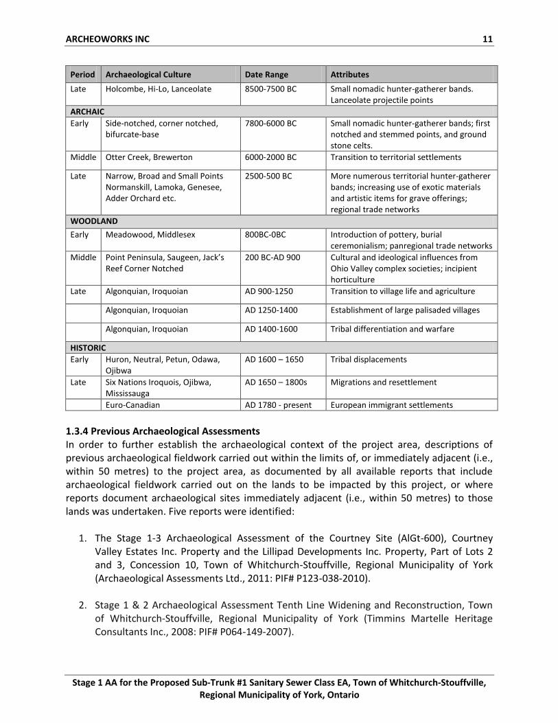
Having noted the presence of these sites in relation to the study area, it is useful to place them in the proper context by reviewing the cultural history of the occupation in Southern Ontario provided in Table 5. This data provides an understanding of the potential cultural activity that may have occurred within the study area. Table 5: History of Occupation in Southern Ontario
Period Archaeological Culture Date Range Attributes
PALEO-INDIAN
Early Gainey, Barnes, Crowfield 9000-8500 BC Big game hunters. Fluted projectile points
ARCHEOWORKS INC 11
Stage 1 AA for the Proposed Sub-Trunk #1 Sanitary Sewer Class EA, Town of Whitchurch-Stouffville, Regional Municipality of York, Ontario
Period Archaeological Culture Date Range Attributes
Late Holcombe, Hi-Lo, Lanceolate 8500-7500 BC Small nomadic hunter-gatherer bands. Lanceolate projectile points
ARCHAIC
Early Side-notched, corner notched, bifurcate-base
7800-6000 BC Small nomadic hunter-gatherer bands; first notched and stemmed points, and ground stone celts.
Middle Otter Creek, Brewerton 6000-2000 BC Transition to territorial settlements
Late Narrow, Broad and Small Points Normanskill, Lamoka, Genesee, Adder Orchard etc.
2500-500 BC More numerous territorial hunter-gatherer bands; increasing use of exotic materials and artistic items for grave offerings; regional trade networks
WOODLAND
Early Meadowood, Middlesex 800BC-0BC Introduction of pottery, burial ceremonialism; panregional trade networks
Middle Point Peninsula, Saugeen, Jack’s Reef Corner Notched
200 BC-AD 900 Cultural and ideological influences from Ohio Valley complex societies; incipient horticulture
Late Algonquian, Iroquoian AD 900-1250 Transition to village life and agriculture
Algonquian, Iroquoian AD 1250-1400 Establishment of large palisaded villages
Algonquian, Iroquoian AD 1400-1600 Tribal differentiation and warfare
HISTORIC
Early Huron, Neutral, Petun, Odawa, Ojibwa
AD 1600 – 1650 Tribal displacements
Late Six Nations Iroquois, Ojibwa, Mississauga
AD 1650 – 1800s Migrations and resettlement
Euro-Canadian AD 1780 - present European immigrant settlements
1.3.4 Previous Archaeological Assessments In order to further establish the archaeological context of the project area, descriptions of previous archaeological fieldwork carried out within the limits of, or immediately adjacent (i.e., within 50 metres) to the project area, as documented by all available reports that include archaeological fieldwork carried out on the lands to be impacted by this project, or where reports document archaeological sites immediately adjacent (i.e., within 50 metres) to those lands was undertaken. Five reports were identified:
1. The Stage 1-3 Archaeological Assessment of the Courtney Site (AlGt-600), Courtney Valley Estates Inc. Property and the Lillipad Developments Inc. Property, Part of Lots 2 and 3, Concession 10, Town of Whitchurch-Stouffville, Regional Municipality of York (Archaeological Assessments Ltd., 2011: PIF# P123-038-2010).
2. Stage 1 & 2 Archaeological Assessment Tenth Line Widening and Reconstruction, Town of Whitchurch-Stouffville, Regional Municipality of York (Timmins Martelle Heritage Consultants Inc., 2008: PIF# P064-149-2007).
ARCHEOWORKS INC 12
Stage 1 AA for the Proposed Sub-Trunk #1 Sanitary Sewer Class EA, Town of Whitchurch-Stouffville, Regional Municipality of York, Ontario
3. Construction Monitoring – Tenth Line Widening and Reconstruction. Town of Whitchurch-Stouffville, Regional Municipality of York (Timmins Martelle Heritage Consultants Inc. 2010: PIF# P083-057-2010).
4. Stage 1 A. A. of the Main Street and Tenth Line Improvements, Town of Whitchurch-Stouffville, R. M. of York, Ontario Formerly Markham and Whitchurch Townships, County of York (Archaeological Services Inc., 2003).
5. REVISED: Report on the 2009 and 2010 Stage 1&2 Archaeological Assessment of Hoover-Thirty Development Limited's Land, Lot 34, Concession 10, Whitchurch Township, Town of Whitchurch-Stouffville, Regional Municipality of York, Ontario Draft Plan No. 19T(W)-07.003 (This Land Archaeology, 2011).
In an attempt to adhere to Section 7.5.8, Standard 4 of the 2011 S&G, the MTCS had been contacted in order to obtain copies of all reports listed above. No response was received at the time of report completion with regards to the following reports:
1. Stage 1 A. A. of the Main Street and Tenth Line Improvements, Town of Whitchurch-Stouffville, R. M. of York, Ontario Formerly Markham and Whitchurch Townships, County of York (Archaeological Services Inc., 2003).
2. REVISED: Report on the 2009 and 2010 Stage 1&2 Archaeological Assessment of Hoover-
Thirty Development Limited's Land, Lot 34, Concession 10, Whitchurch Township, Town of Whitchurch-Stouffville, Regional Municipality of York, Ontario Draft Plan No. 19T(W)-07.003 (This Land Archaeology, 2011).
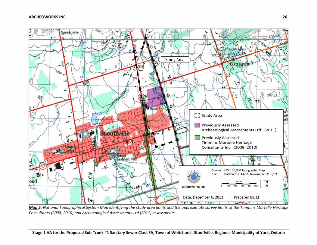
In 2011, Archaeological Assessments Ltd. undertook a Stage 1-3 AA for the Lillipad Development Inc. Property, on 26 hectares of part of Lots 2 and 3, Concession 10, in the Town of Whitchurch-Stouffville. This report reviews land that encompasses a portion of the current study area (see Map 5). The Stage 1 identified archaeological potential based on the presence of Reesor Creek, and a historic structure within the subject lands. During the Stage 2 AA, the Courtney Site (AlGt-600) was located; a small indeterminate aboriginal campsite located on tablelands west of Reesor Creek, contained a single Onondaga chert biface thinning flake. This site was subject to a Stage 3 AA, however, no artifacts were recovered during the Stage 3 and the Courtney Site (AlGt-600) was found to have no further cultural heritage value and was not recommended for Stage 4 mitigation. Therefore, there are no further concerns for this site. Timmins Martelle Heritage Consultants Inc. (TMHC) was retained to undertake a Stage 1-2 AA in support of the proposed widening and reconstruction of Tenth Line in the Town of Whitchurch-Stouffville. The Tenth Line Expansion Area, an approximately three kilometre corridor, is directly adjacent to the current study area (see Map 4). The Stage 1 background study indicated that much of the study area contained archaeological potential. A field review determined that extensive disturbances existed in the study area due to prior road and building construction, as well as utility installation. However, the southern portion of the study area was found to be
ARCHEOWORKS INC 13
Stage 1 AA for the Proposed Sub-Trunk #1 Sanitary Sewer Class EA, Town of Whitchurch-Stouffville, Regional Municipality of York, Ontario
largely undisturbed, and a Stage 2 AA was recommended for this area. During the Stage 2 AA a scatter of Euro-Canadian artifacts was found, but determined to be an insignificant archaeological find and no further work was recommended. Additionally, as the study area was found to be in close proximity to the early 16th century Mantle Site, a village and cemetery site identified by Archaeological Services Inc., monitoring of construction activities in areas close to this site was recommended. Following the Stage 1-2 AA for the proposed widening of Tenth Line in Stouffville, TMHC was retained to conduct monitoring of the construction activities taking place south of Hoover Drive. Although the Stage 2 field survey did not result in the discovery of any significant archaeological resources, due to the close proximity of the construction zone to the Mantle Site and the possibility that archaeological or burial features, such as an ossuary, could exist outside of the village limits, TMHC undertook the monitoring of asphalt and fill removal and the excavation of a drainage basin. No archaeological resources or features were identified due to extensive disturbances and it was recommended that no further archaeological concerns exist for the study area. 1.3.5 Date(s) of Property Inspection The Stage 1 property inspection of the five alternatives was undertaken on February 4th, 2013.
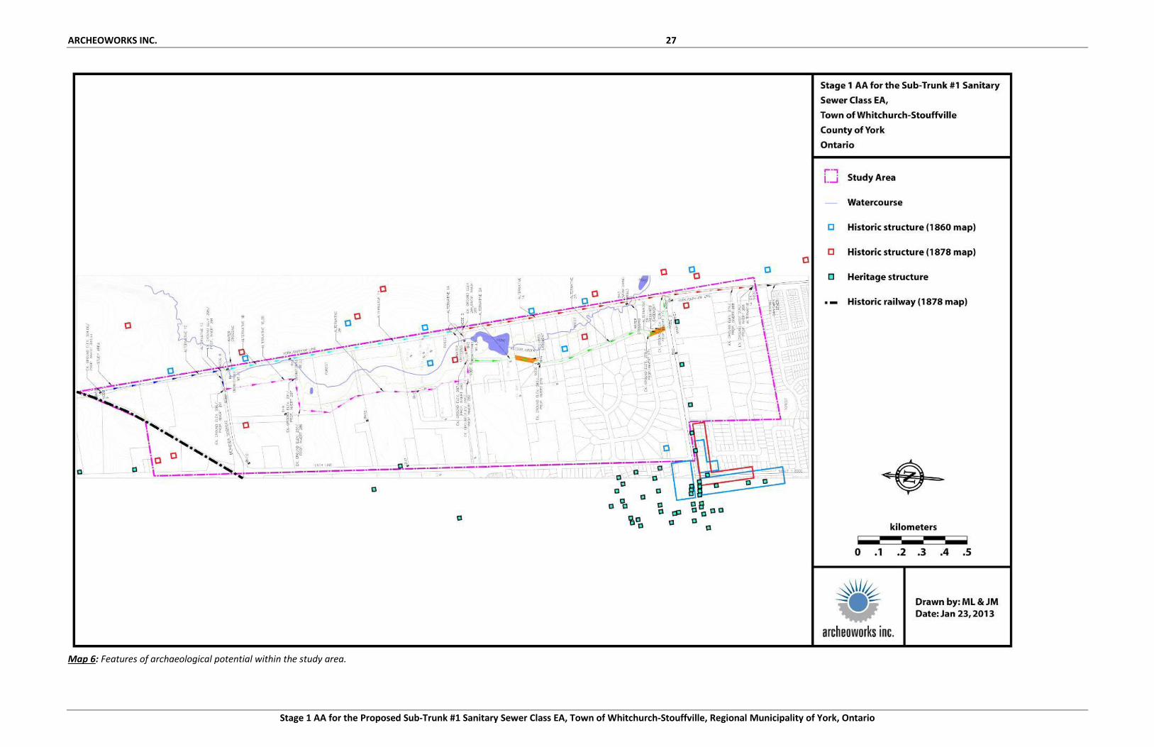
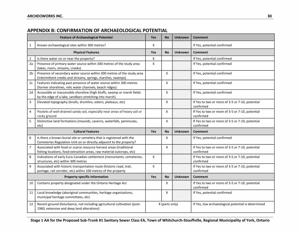
1.4 Confirmation of Archaeological Potential Based on the information gathered from the background research documented in the preceding section, we confirm that there is potential for the recovery of archaeological resources within undisturbed portions of the study area limits. Features contributing to archaeological potential are summarized in Appendix B and are presented on Map 6.
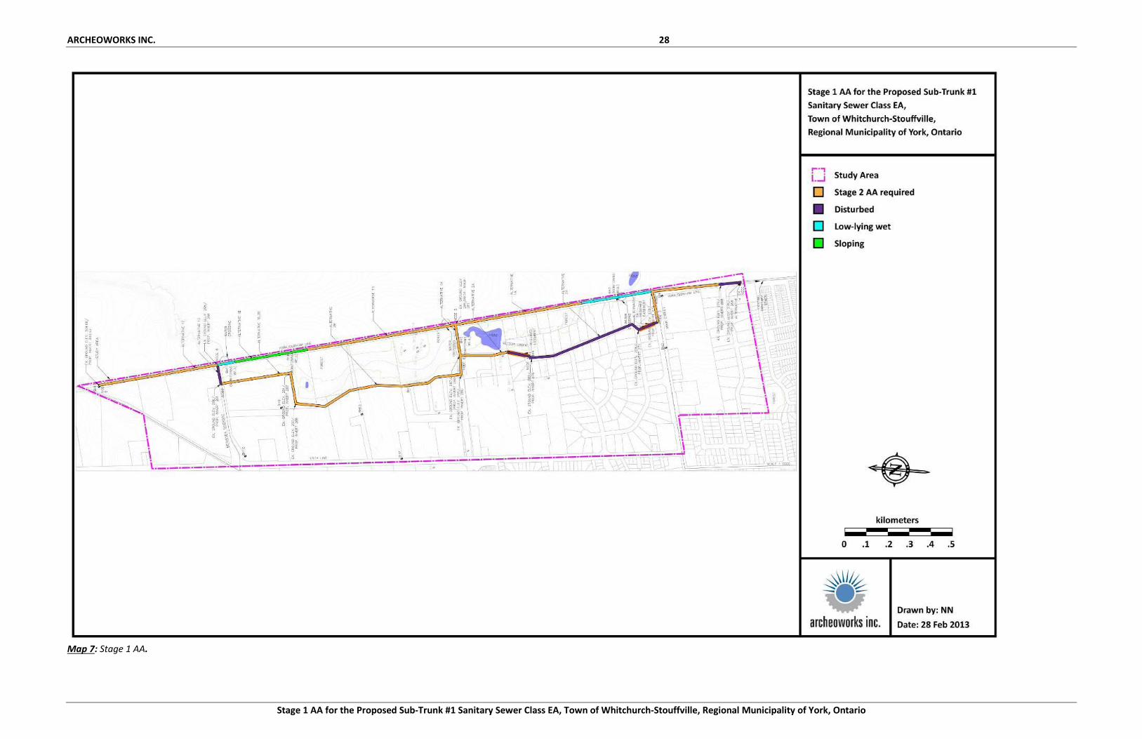
2.0 FIELD METHODS This property inspection was conducted in compliance with the 2011 S&G, published by the MTCS. The weather and lighting conditions during the property inspection permitted good visibility of all parts of the study area and were conducive to the identification and recovery of archaeological resources. This property inspection was confined to a 10 metre wide swath along the five proposed alternatives (see Map 7). The entire length of each alternative was inspected, and coverage was sufficient to identify the presence or absence of any features of archaeological potential. All alternatives were evaluated for features indicating archaeological potential, features indicating that archaeological potential has been removed, and features indicating that archaeological potential is low.
ARCHEOWORKS INC 14
Stage 1 AA for the Proposed Sub-Trunk #1 Sanitary Sewer Class EA, Town of Whitchurch-Stouffville, Regional Municipality of York, Ontario
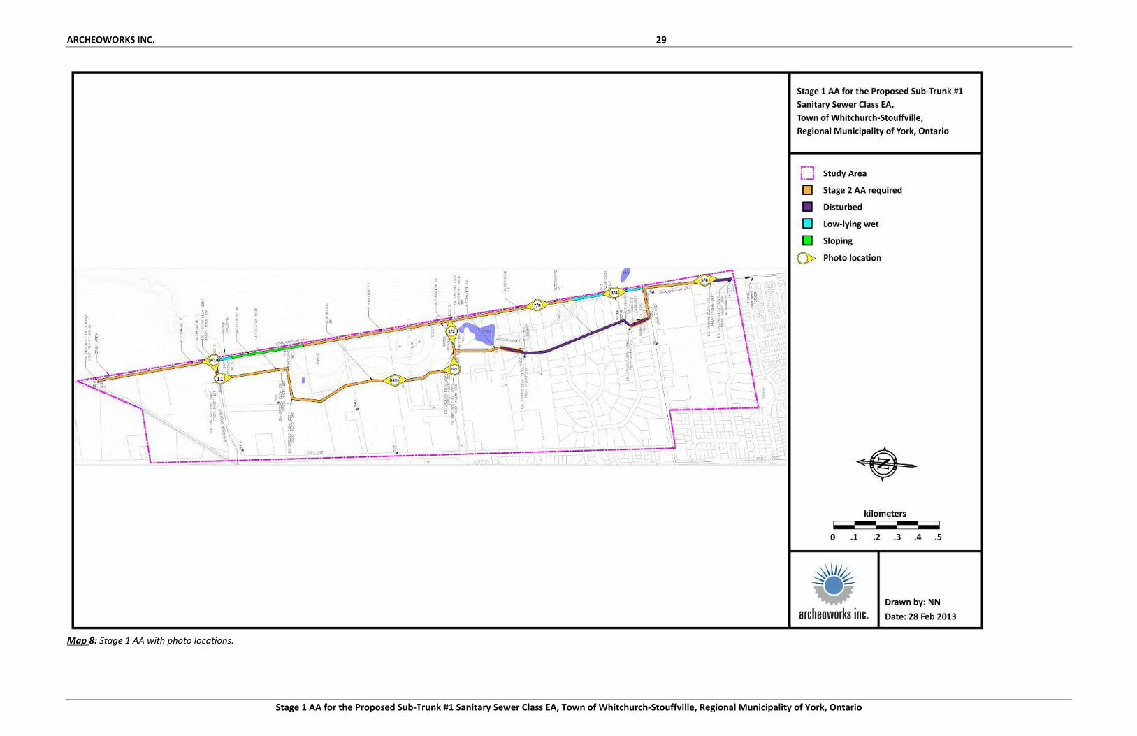
Photographic images of the property inspection are presented within Appendix C. Location and orientation information associated with all photographs taken in the field is provided within Map 8.
3.0 ANALYSIS AND CONCLUSIONS
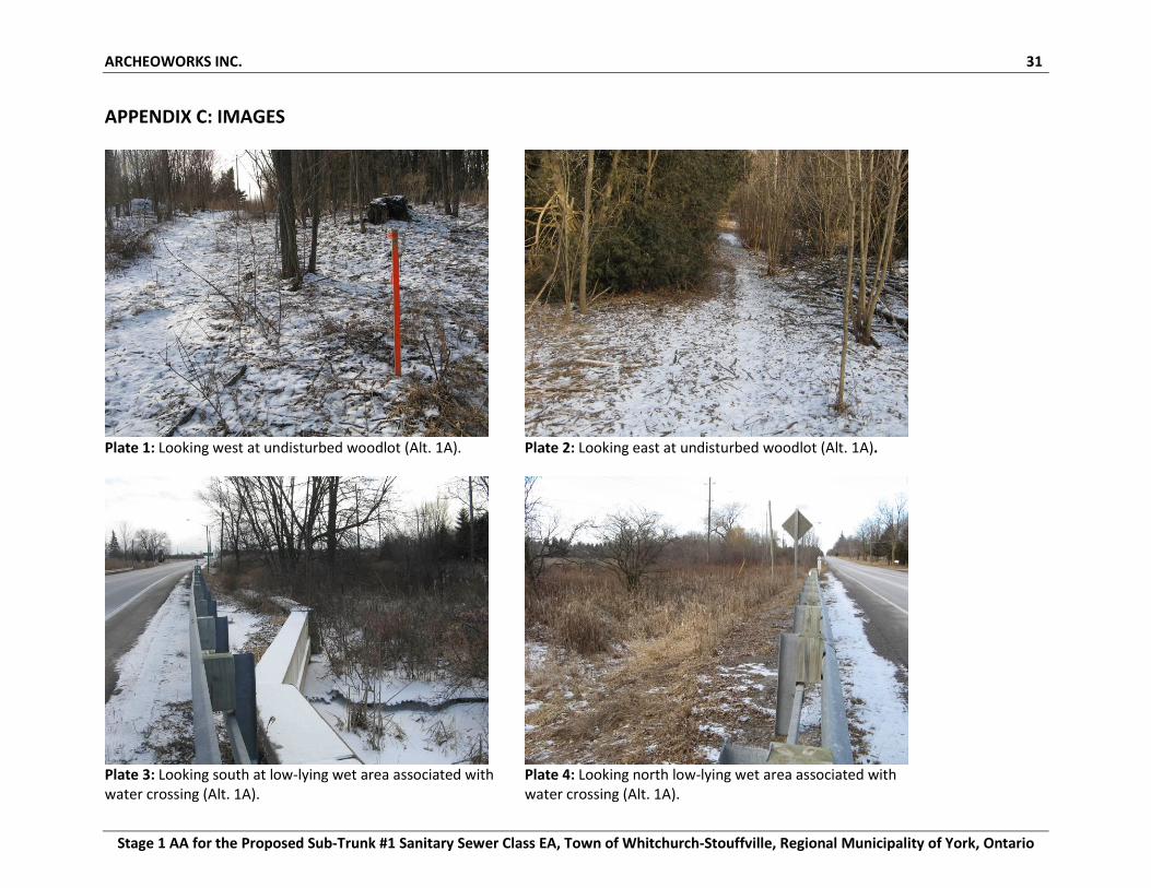
3.1 Alternative 1A Alternative 1A runs within a woodlot and along the west side of York/ Durham Line (see Map 2). A 10 metre wide swath (five metres on either side of the alternative) within the woodlot and a 10 metre wide swath along the west side of York/ Durham Line from the edge of the shoulder were evaluated. The portion of the alternative that runs within the woodlot was identified as undisturbed and having archaeological potential (see Images 1-2). Where the alternative runs along York/ Durham Line, this segment contains a mixture of low-lying wet terrain (see Images 3-4), disturbed terrain (grading, underground utilities), and potentially undisturbed grassed margins and residential frontages (see Images 5-8). Should Alternative 1A be selected as the preferred alignment, further Stage 2 AA will be required within the undisturbed woodlot, grassed margins, and residential frontages (see Map 7).
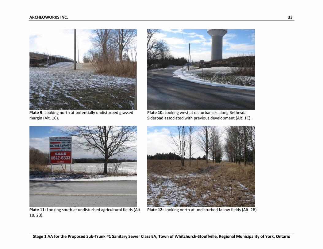
3.2 Alternative 1B Alternative 1B runs within an agricultural field south of Bethesda Sideroad and along the west side of York/ Durham Line (see Map 2). A 10 metre wide swath (five metres on either side of the alternative) within the agricultural field and a 10 metres wide swath along the west side of York/ Durham Line from the edge of the shoulder were evaluated. The portion of the alternative that runs within the agricultural field was identified as undisturbed and having archaeological potential. Where the alternative runs along York/ Durham Line, south from Bethesda Road the alternative falls within low-lying wet terrain for approximately 60 metres. Immediately south of the low-lying wet area, the alternative falls within steeply sloping terrain for approximately 340 metres. South of the sloping terrain, the alternative falls within potentially undisturbed grassed and fallow margins. Should Alternative 1B be selected as the preferred alignment, further Stage 2 AA will be required within the undisturbed agricultural field and grassed and fallow margins (see Map 7).
ARCHEOWORKS INC 15
Stage 1 AA for the Proposed Sub-Trunk #1 Sanitary Sewer Class EA, Town of Whitchurch-Stouffville, Regional Municipality of York, Ontario
3.3 Alternative 1C Alternative 1C runs along the west side of York/ Durham Line and along the north side of Bethesda Sideroad (see Map 2). A 10 metre wide swath along the west side of York/ Durham Line from the edge of the shoulder and a 10 metre wide swath along the north side of Bethesda Sideroad were evaluated. The portion of the alternative that runs along York/ Durham Line was identified as undisturbed and having archaeological potential beyond the ditching associated with the York/ Durham Line roadway (see Image 9). Where the alternative runs along Bethesda Sideroad, this segment is entirely disturbed from previous development activities and gravel infill (see Image 10). Should Alternative 1C be selected as the preferred alignment, further Stage 2 AA will be required within the undisturbed margin beyond the roadway ditching along the west side of York/ Durham Line (see Map 7).
3.4 Alternative 2A Alternative 2A runs within a woodlot, an existing residential subdivision following Cam Fella Boulevard, and Main Street (see Map 2). A 10 metre wide swath (five metres on either side of the alternative) within the woodlot and existing subdivision, and a 10 metre wide swath along the north side Main Street from the road’s edge were evaluated. The portion of the alternative that runs within the woodlot was identified as undisturbed and having archaeological potential. The segment of the alternative that falls within the existing residential subdivision has been entirely graded and filled and contains no archaeological potential. The reminder of the alternative that runs along the north side of Main Street falls within potentially undisturbed grassed margins. Should Alternative 2A be selected as the preferred alignment, further Stage 2 AA will be required within the undisturbed woodlot and grassed margin along the north side of Main Street (see Map 7).
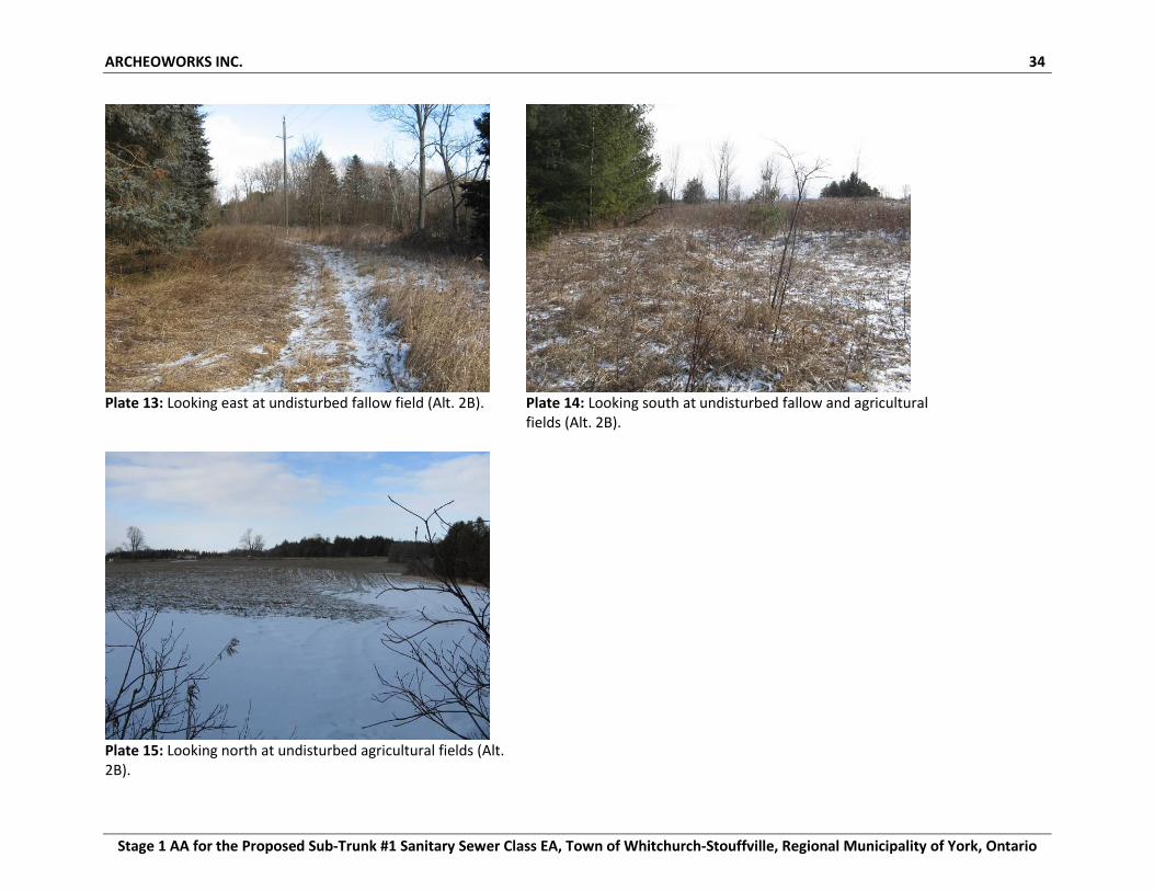
3.5 Alternative 2B Alternative 2B runs within agricultural and fallow fields (see Map 2). A 10 metre wide swath (five metres on either side of the alternative) was evaluated. The entire alternative was identified as undisturbed and having archaeological potential (see Images 11-15).
ARCHEOWORKS INC 16
Stage 1 AA for the Proposed Sub-Trunk #1 Sanitary Sewer Class EA, Town of Whitchurch-Stouffville, Regional Municipality of York, Ontario
Should Alternative 2B be selected as the preferred alignment, further Stage 2 AA will be required for the entire alternative (see Map 7).
4.0 RECOMMENDATIONS In light of these results, the following recommendations are presented:
1. Those portions of each alternative, described in Section 3.0, that are considered to have low archaeological potential or may be classified as disturbed, are exempted from further assessment.
2. Those portions of each alternative, which were determined to contain archaeological potential, should be subjected to a Stage 2 AA once a preferred alternative is selected:
Parts of the study area that are agriculturally active land should be ploughed, weathered, and then subjected to pedestrian survey at five metre intervals, in accordance with Section 2.1.1 in the 2011 S&G.
Portions of the study area that have not been agriculturally active land in the recent past, or cannot be subjected to ploughing, should be subjected to a shovel test pit form of survey at five metre intervals, in accordance with Section 2.1.2 in the 2011 S&G.
The above recommendations are subject to MTCS approval. No excavation activities shall take place within the study area prior to the MTCS (Heritage Operations Unit) confirming in writing that all archaeological licensing and technical review requirements have been satisfied.
5.0 ADVICE ON COMPLIANCE WITH LEGISLATION
1. This report is submitted to the MTCS as a condition of licensing in accordance with Part VI of the Ontario Heritage Act, R.S.O. 1990, c0.18. The report is reviewed to ensure that it complies with the standards and guidelines that are issued by the Minister, and that the archaeological fieldwork and report recommendations ensure the conservation, protection and preservation of the cultural heritage of Ontario. When all matters relating to archaeological sites within the project area of a development proposal have been addressed to the satisfaction of the MTCS, a letter will be issued by the ministry stating that there are no further concerns with regard to alterations to archaeological sites by the proposed development.
2. It is an offence under Sections 48 and 69 of the Ontario Heritage Act for any party other than a licensed archaeologist to make any alteration to a known archaeological site or to
ARCHEOWORKS INC 17
Stage 1 AA for the Proposed Sub-Trunk #1 Sanitary Sewer Class EA, Town of Whitchurch-Stouffville, Regional Municipality of York, Ontario
remove any artifact or other physical evidence of past human use or activity from the site, until such time as a licensed archaeologist has completed archaeological fieldwork on the site, submitted a report to the Minister stating that the site has no further cultural heritage value or interest, and the report has been filed in the Ontario Public Register of Archaeology Reports referred to in Section 65.1 of the Ontario Heritage Act.
3. Should previously undocumented archaeological resources be discovered, they may be a new archaeological site and therefore subject to Section 48 (1) of the Ontario Heritage Act. The proponent or person discovering the archaeological resources must cease alteration of the site immediately and engage a licensed consultant archaeologist to carry out archaeological fieldwork, in compliance with Section 48 (1) of the Ontario Heritage Act.
4. The Cemeteries Act, R.S.O. 1990 c. C.4 and the Funeral, Burial and Cremation Services Act, 2002, S.O. 2002, c.33 (when proclaimed in force) require that any person discovering human remains must notify the police or coroner and the Registrar of Cemeteries at the Ministry of Consumer Services.
Under Section 6 of Regulation 881 of the Ontario Heritage Act, Archeoworks Inc. will, “keep in safekeeping all objects of archaeological significance that are found under the authority of the licence and all field records that are made in the course of the work authorized by the licence, except where the objects and records are donated to Her Majesty the Queen in right of Ontario or are directed to be deposited in a public institution under subsection 66 (1) of the Act.”
ARCHEOWORKS INC 18
Stage 1 AA for the Proposed Sub-Trunk #1 Sanitary Sewer Class EA, Town of Whitchurch-Stouffville, Regional Municipality of York, Ontario
6.0 BIBLIOGRAPHY AND SOURCES
Archaeological Services Inc. (2013). Featured Projects: The Mantle Site. [Online]. Available at http://www.iasi.to/web.nsf/page/The+Mantle+Site!opendocument [Accessed 24 January 2013].
Archaeological Assessments Ltd. (2011). The Stage 1-3 Archaeological Assessment of the Courtney Site (AlGt-600), Courtney Valley Estates Inc. Property and the Lillipad Developments Inc. Property, Part of Lots 2 and 3, Concession 10, Town of Whitchurch-Stouffville, Regional Municipality of York. PIF#: P123-038-2010. Barkley, J. (1993). Whitchurch Township. [Online]. Available at: http://www.ourroots.ca/e/toc.aspx?id=6235 [Accessed 21 December 2012]. Barnett, P.J., Sharpe, D.R., Russell, H.A.J., Brennand, T.A., Gorrell, G. Kenny, F. and Pugin A. (1998). On the Origins of the Oak Ridges Moraine. The Canadian Journal of Earth Sciences, 35, p.1157-1167. [Online]. Available at: http://stormcoalition.org/resources/Barnett-On%20the%20origin%20of%20the%20Oak%20Ridges%20Moraine.pdf [Accessed 21 December 2012]. Birch, J. (2010). Coalescence and Conflict in Iroquoian Ontario. [Online]. Available at: http://uga.academia.edu/JenniferBirch/Papers/183903/Coalescence_and_Conflict_in_Iroquoian_Ontario [Accessed 21 December 2012]. Bursey, J., Daechsel, H., Hinshelwood, A., and Murphy, C. (2013a). The Archaeology of Ontario– The First People of Ontario: The Paleo-Indians. [Online]. Available at: http://www.ontarioarchae ology.on.ca/summary/paleo.php [Accessed 18 January 2013]. Bursey, J., Daechsel, H., Hinshelwood, A., and Murphy, C. (2013b). The Archaeology of Ontario– The Archaic Period. [Online]. Available at: http://www.ontarioarchaeology. on.ca/summary/archaic.htm [Accessed 17 January 2013]. Bursey, J., Daechsel, H., Hinshelwood, A., and Murphy, C. (2013c). The Archaeology of Ontario – The Early Woodland Period. [Online]. Available at: http://www.ontarioarchaeology.on.ca /summary/earlyw.php [Accessed 16 January 2013]. Bursey, J., Daechsel, H., Hinshelwood, A., and Murphy, C. (2013d). The Archaeology of Ontario – The Late Woodland Period. [Online]. Available at: http://www.ontarioarchaeology.on.ca /summary/latew.php [Accessed 17 January 2013]. Chapman, L.J. and Putnam, D.F. (1984). The Physiography of Southern Ontario. 3rd ed. Ontario Geological Survey, Special Volume 2. Toronto: Ministry of Natural Resources.
ARCHEOWORKS INC 19
Stage 1 AA for the Proposed Sub-Trunk #1 Sanitary Sewer Class EA, Town of Whitchurch-Stouffville, Regional Municipality of York, Ontario
Ellis, C.J. and Deller, D.B. (1990). Paleo-Indians. In C.J. Ellis, and N. Ferris, (Eds.). The Archaeology of Southern Ontario to A.D. 1650. London, Ontario: Occasional Publication of the London Chapter, OAS, pp. 37-64. Ellis, C.J., Kenyon, I.T., and Spence, M.W. (1990). The Archaic. In C.J. Ellis, and N. Ferris, (Eds.). The Archaeology of Southern Ontario to A.D. 1650. London, Ontario: Occasional Publication of the London Chapter, OAS, pp. 65-124. Experimental Farms Service (1945). Soil Map of Durham County. Ottawa: Hydrographic and Map Service. Google (2012). Google Street View Images. Retrieved from Google Earth application, January 18, 2012. Government of Ontario (2009). Ontario Heritage Act. Available at: http://www.e-laws.gov.on.ca/html/statutes/english/elaws_statutes_90o18_e.htm [Accessed 15 October 2012]. Government of Ontario (2009). Ontario Environmental Assessment Act. Available at: http://www.e-laws.gov.on.ca/html/statutes/english/elaws_statutes_90o18_e.htm [Accessed 15 November 2012]. Government of Ontario (2008). Ontario Heritage Properties Database. [Online]. Available at: http://www.hpd.mcl.gov.on.ca [Accessed 21 December 2012]. Harris, R.C. and Warkentin, J. (2000).Canada Before Confederation: A Study in Historical Geography. Canada: McGill-Queen University Press. James, I. (2012). Email to L. Templeton re. Designated and Listed Heritage Structures within the Town of Whitchurch-Stouffville, 20 December 2012. Johnson, D. (2004). Connecting People to Place: Great Lakes Aboriginal History in Cultural Context. [Online]. Available at: http://www.attorneygeneral.jus.gov.on.ca/ inquiries/ipperwash/transcripts/pdf/P1_Tab_1.pdf [Accessed 21 December 2012]. Kapches, M. (2007). The Iroquoian Longhouse: Architectural and Cultural Identity. In Kerber, J.E. (Ed.) Archaeology of the Iroquois: Selected Readings and Research Sources. Syracuse, New York: Syracuse University Press, pp. 174-190. Karrow, P.F. and Warner, B.G. (1990). The Geological and Biological Environment for Human Occupation in Southern Ontario. In C.J. Ellis, and N. Ferris (Eds.). The Archaeology of Southern Ontario to A.D. 1650. London, Ontario: Occasional Publication of the London Chapter, OAS, pp. 5-35.
ARCHEOWORKS INC 20
Stage 1 AA for the Proposed Sub-Trunk #1 Sanitary Sewer Class EA, Town of Whitchurch-Stouffville, Regional Municipality of York, Ontario
Miles & Co. (1878). Illustrated Historical Atlas of the County of York. Toronto Mulvany, C. P. and Adam, G. M. (1885). History of Toronto and County of York, Ontario: containing an outline of the history of the Dominion of Canada, a history of the city of Toronto and the county of York, with the townships, towns, villages, churches, schools; general and local statistics; biographical sketches, etc., etc. Volume 1. [Online]. Available at: http://www.ourroots.ca/toc .aspx?id=3668&qryID=9420b906-028b-49f4-85ad-c5f70662bcf2 [Accessed 21 December 2012]. Natural Resources Canada (1994). National Topographic Survey of Canada, Series A 751, Map 30 M/14. 9th ed. Ottawa. Natural Resources Canada (1988). National Topographic Survey of Canada, Series A 751, Map 31 D/03. 5th ed. Ottawa. Natural Resources Canada (2003). Map of the Area of the 1 August 1805 Treaty [Toronto Purchase]. [Online}. Available at: http://atlas.nrcan.gc.ca/site/english/maps/historical/ indiantreaties/historicaltreaties/p17.gif/image_view [Accessed 21 December 2012]. Neilson, L. (2012). Yonge Street – Governor Simcoe’s Military Road. [Online].Available at: http://thecanadianencyclopedia.com/featured/ [Accessed 21 December 2012]. Ontario Ministry of Tourism, Culture and Sport (MTCS) (2012). Email to L. Templeton re. Sites within a One-Kilometre Radius of the Study Area, 16 November 2012. Ontario Ministry of Tourism, Culture and Sport (MTCS) (2011a). Criteria for Determining Archaeological Potential: A Checklist for the Non-Specialist. Toronto. Ontario Ministry of Tourism, Culture and Sport (MTCS) (2011b). Standards and Guidelines for Consulting Archaeologists. Toronto. Scadding, Henry. (1873). Toronto of Old: Collections and Recollections- Illustrative of the Early Settlement and Social Life of the Capital of Ontario. Toronto: Adam, Stevenson & Co. Shipway, P. (2013). Email to L. Templeton re. Designated and Listed Heritage Structures within the Township of Uxbridge, 22 January 2013. Smith, W.H. (1851). Canada: Past, Present and Future: Being a Historical, Geographical, Geological and Statistical Account of Canada West. Toronto, Ontario: Thomas Maclear Publisher.
ARCHEOWORKS INC 21
Stage 1 AA for the Proposed Sub-Trunk #1 Sanitary Sewer Class EA, Town of Whitchurch-Stouffville, Regional Municipality of York, Ontario
Surtees, R.J. (1994). Land Cessions, 1763-1830. In Rogers, E.S. (Ed.) Aboriginal Ontario: Historical Perspectives on the First Nations. Toronto, Ontario: Dundurn Press Limited, pp. 92-121. Timmins Martelle Heritage Consultants Inc. (2008). Stage 1 & 2 Archaeological Assessment Tenth Line Widening and Reconstruction, Town of Whitchurch-Stouffville, Regional Municipality of York, PIF#: P064-149-2007. Timmins Martelle Heritage Consultants Inc. (2010). Construction Monitoring – Tenth Line Widening and Reconstruction. Town of Whitchurch-Stouffville, Regional Municipality of York (Timmins Martelle Heritage Consultants Inc., PIF#: P083-057-2010. Toronto and Region Conservation Authority (TRCA) (2002). Duffins Creek – State of the Watershed Report: Human Heritage.[Online]. Available at: http://trca.on.ca/dotAsset /37427.pdf [Accessed 21 December 2012]. Township of Uxbridge. (2010). Designated Properties – Under the Ontario Heritage Act and Non-Designated Properties – Under the Ontario Heritage Act. [Online] Available at: http://www.town.uxbridge.on.ca/heritage [Accessed 22 January 2013]. Tremaine, G. (1860) Tremaine’s Map of the County of York, Canada West. Toronto. Trigger, B.G. (1994). The Original Iroquoians: Huron, Petun and Neutral. In E.S. Rogers, (Ed.). Aboriginal Ontario: Historical Perspectives on the First Nations. Toronto, Ontario: Dundurn Press Limited, pp. 41-63. Warrick, G.A. (1990). A Population History of the Huron-Petun, A.D. 900-1650. Ottawa: National Library of Canada. Warrick, G.A. (2007). The Precontact Iroquoian Occupation of Southern Ontario. In Kerber, J.E. (Ed.) Archaeology of the Iroquois: Selected Readings and Research Sources. Syracuse, New York: Syracuse University Press, pp. 124-164. Warrick, G. (2008). A Population History of the Huron-Petun, A.D. 500-1650. New York: Cambridge University Press. Wright, J.V. (1995). A History of the Native People of Canada: Volume I (10,000 – 1,000B.C.). Hull, Quebec: Museum of Civilization.
ARCHEOWORKS INC. 22
Stage 1 AA for the Proposed Sub-Trunk #1 Sanitary Sewer Class EA, Town of Whitchurch-Stouffville, Regional Municipality of York, Ontario
APPENDIX A: MAPS
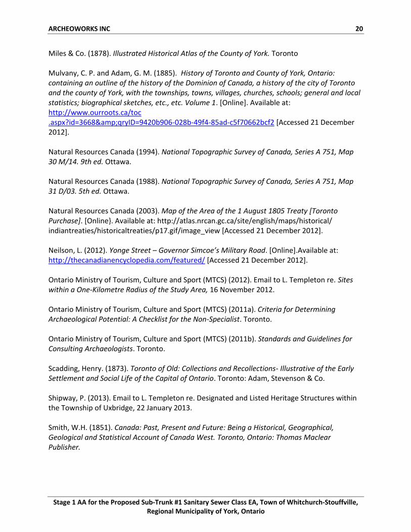
Map 1: National Topographic Survey map (Natural Resources Canada, 1994) showing study area limits.
ARCHEOWORKS INC. 23
Stage 1 AA for the Proposed Sub-Trunk #1 Sanitary Sewer Class EA, Town of Whitchurch-Stouffville, Regional Municipality of York, Ontario
Map 2: Base plan illustrating the locations of the Alternatives.
ARCHEOWORKS INC. 24
Stage 1 AA for the Proposed Sub-Trunk #1 Sanitary Sewer Class EA, Town of Whitchurch-Stouffville, Regional Municipality of York, Ontario
Map 3: Study area within Tremaine Map of the County of York (Tremaine, 1860).
ARCHEOWORKS INC. 25
Stage 1 AA for the Proposed Sub-Trunk #1 Sanitary Sewer Class EA, Town of Whitchurch-Stouffville, Regional Municipality of York, Ontario
Map 4: Study area within the Illustrated Historical Atlas of the County of York (Miles & Co., 1878).
ARCHEOWORKS INC. 26
Stage 1 AA for the Proposed Sub-Trunk #1 Sanitary Sewer Class EA, Town of Whitchurch-Stouffville, Regional Municipality of York, Ontario
Map 5: National Topographical System Map identifying the study area limits and the approximate survey limits of the Timmins Martelle Heritage Consultants (2008, 2010) and Archaeological Assessments Ltd (2011) assessments.
ARCHEOWORKS INC. 27
Stage 1 AA for the Proposed Sub-Trunk #1 Sanitary Sewer Class EA, Town of Whitchurch-Stouffville, Regional Municipality of York, Ontario
Map 6: Features of archaeological potential within the study area.
ARCHEOWORKS INC. 28
Stage 1 AA for the Proposed Sub-Trunk #1 Sanitary Sewer Class EA, Town of Whitchurch-Stouffville, Regional Municipality of York, Ontario
Map 7: Stage 1 AA.
ARCHEOWORKS INC. 29
Stage 1 AA for the Proposed Sub-Trunk #1 Sanitary Sewer Class EA, Town of Whitchurch-Stouffville, Regional Municipality of York, Ontario
Map 8: Stage 1 AA with photo locations.
ARCHEOWORKS INC. 30
Stage 1 AA for the Proposed Sub-Trunk #1 Sanitary Sewer Class EA, Town of Whitchurch-Stouffville, Regional Municipality of York, Ontario
APPENDIX B: CONFIRMATION OF ARCHAEOLOGICAL POTENTIAL Feature of Archaeological Potential Yes No Unknown Comment
1 Known archaeological sites within 300 metres? X If Yes, potential confirmed
Physical Features Yes No Unknown Comment
2 Is there water on or near the property? X If Yes, potential confirmed
2a Presence of primary water source within 300 metres of the study area (lakes, rivers, streams, creeks)
X If Yes, potential confirmed
2b Presence of secondary water source within 300 metres of the study area (intermittent creeks and streams, springs, marshes, swamps)
X If Yes, potential confirmed
2c Features indicating past presence of water source within 300 metres (former shorelines, relic water channels, beach ridges)
X If Yes, potential confirmed
2d Accessible or inaccessible shoreline (high bluffs, swamp or marsh fields by the edge of a lake, sandbars stretching into marsh)
X If Yes, potential confirmed
3 Elevated topography (knolls, drumlins, eskers, plateaus, etc) X If Yes to two or more of 3-5 or 7-10, potential confirmed
4 Pockets of well-drained sandy soil, especially near areas of heavy soil or rocky ground
X If Yes to two or more of 3-5 or 7-10, potential confirmed
5 Distinctive land formations (mounds, caverns, waterfalls, peninsulas, etc)
X If Yes to two or more of 3-5 or 7-10, potential confirmed
Cultural Features Yes No Unknown Comment
6 Is there a known burial site or cemetery that is registered with the Cemeteries Regulation Unit on or directly adjacent to the property?
X If Yes, potential confirmed
7 Associated with food or scarce resource harvest areas (traditional fishing locations, food extraction areas, raw material outcrops, etc)
X If Yes to two or more of 3-5 or 7-10, potential confirmed
8 Indications of early Euro-Canadian settlement (monuments, cemeteries, structures, etc) within 300 metres
X If Yes to two or more of 3-5 or 7-10, potential confirmed
9 Associated with historic transportation route (historic road, trail, portage, rail corridor, etc) within 100 metres of the property
X If Yes to two or more of 3-5 or 7-10, potential confirmed
Property-specific Information Yes No Unknown Comment
10 Contains property designated under the Ontario Heritage Act X If Yes to two or more of 3-5 or 7-10, potential confirmed
11 Local knowledge (aboriginal communities, heritage organizations, municipal heritage committees, etc)
X If Yes, potential confirmed
12 Recent ground disturbance, not including agricultural cultivation (post-1960, extensive and deep land alterations)
X (parts only) If Yes, low archaeological potential is determined
ARCHEOWORKS INC. 31
Stage 1 AA for the Proposed Sub-Trunk #1 Sanitary Sewer Class EA, Town of Whitchurch-Stouffville, Regional Municipality of York, Ontario
APPENDIX C: IMAGES
Plate 1: Looking west at undisturbed woodlot (Alt. 1A).
Plate 2: Looking east at undisturbed woodlot (Alt. 1A).
Plate 3: Looking south at low-lying wet area associated with water crossing (Alt. 1A).
Plate 4: Looking north low-lying wet area associated with water crossing (Alt. 1A).
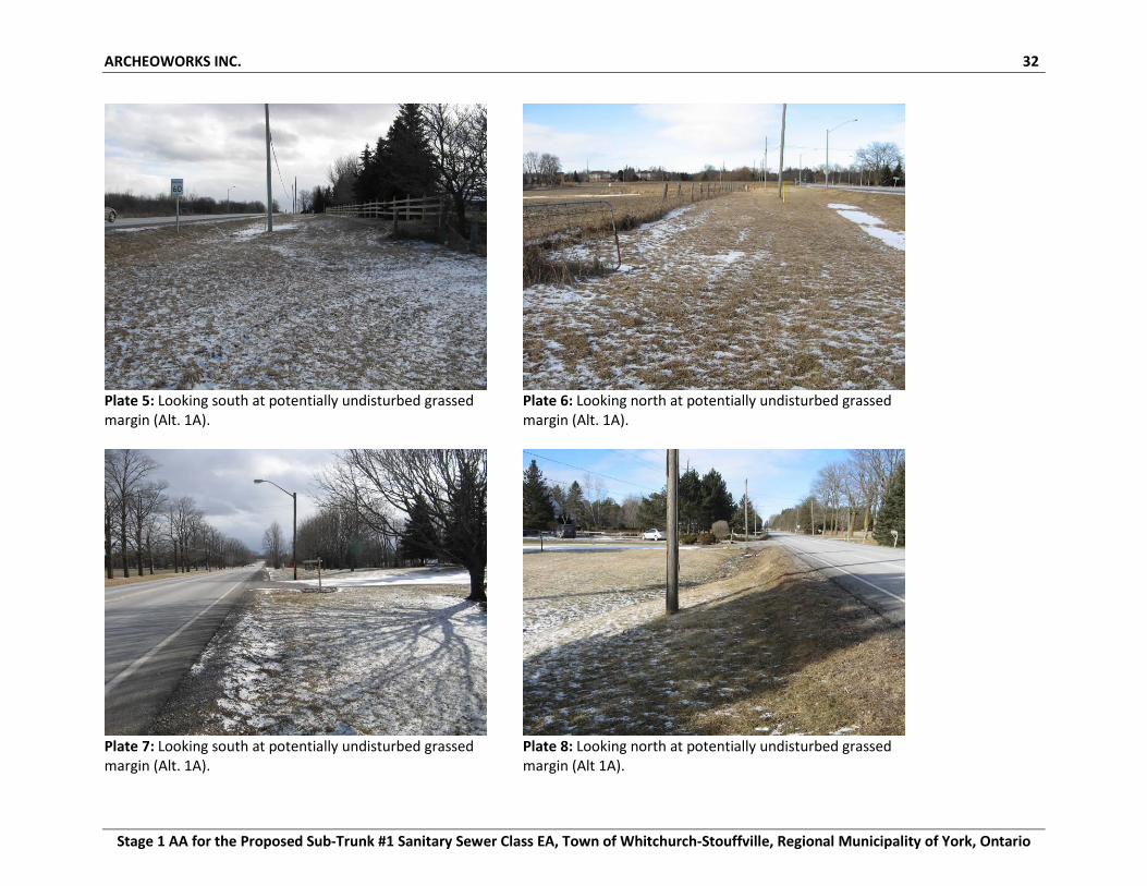
ARCHEOWORKS INC. 32
Stage 1 AA for the Proposed Sub-Trunk #1 Sanitary Sewer Class EA, Town of Whitchurch-Stouffville, Regional Municipality of York, Ontario
Plate 5: Looking south at potentially undisturbed grassed margin (Alt. 1A).
Plate 6: Looking north at potentially undisturbed grassed margin (Alt. 1A).
Plate 7: Looking south at potentially undisturbed grassed margin (Alt. 1A).
Plate 8: Looking north at potentially undisturbed grassed margin (Alt 1A).
ARCHEOWORKS INC. 33
Stage 1 AA for the Proposed Sub-Trunk #1 Sanitary Sewer Class EA, Town of Whitchurch-Stouffville, Regional Municipality of York, Ontario
Plate 9: Looking north at potentially undisturbed grassed margin (Alt. 1C).
Plate 10: Looking west at disturbances along Bethesda Sideroad associated with previous development (Alt. 1C) .
Plate 11: Looking south at undisturbed agricultural fields (Alt. 1B, 2B).
Plate 12: Looking north at undisturbed fallow fields (Alt. 2B).
ARCHEOWORKS INC. 34
Stage 1 AA for the Proposed Sub-Trunk #1 Sanitary Sewer Class EA, Town of Whitchurch-Stouffville, Regional Municipality of York, Ontario
Plate 13: Looking east at undisturbed fallow field (Alt. 2B).
Plate 14: Looking south at undisturbed fallow and agricultural fields (Alt. 2B).
Plate 15: Looking north at undisturbed agricultural fields (Alt. 2B).
ARCHEOWORKS INC. 35
Stage 1 AA for the Proposed Sub-Trunk #1 Sanitary Sewer Class EA, Town of Whitchurch-Stouffville, Regional Municipality of York, Ontario
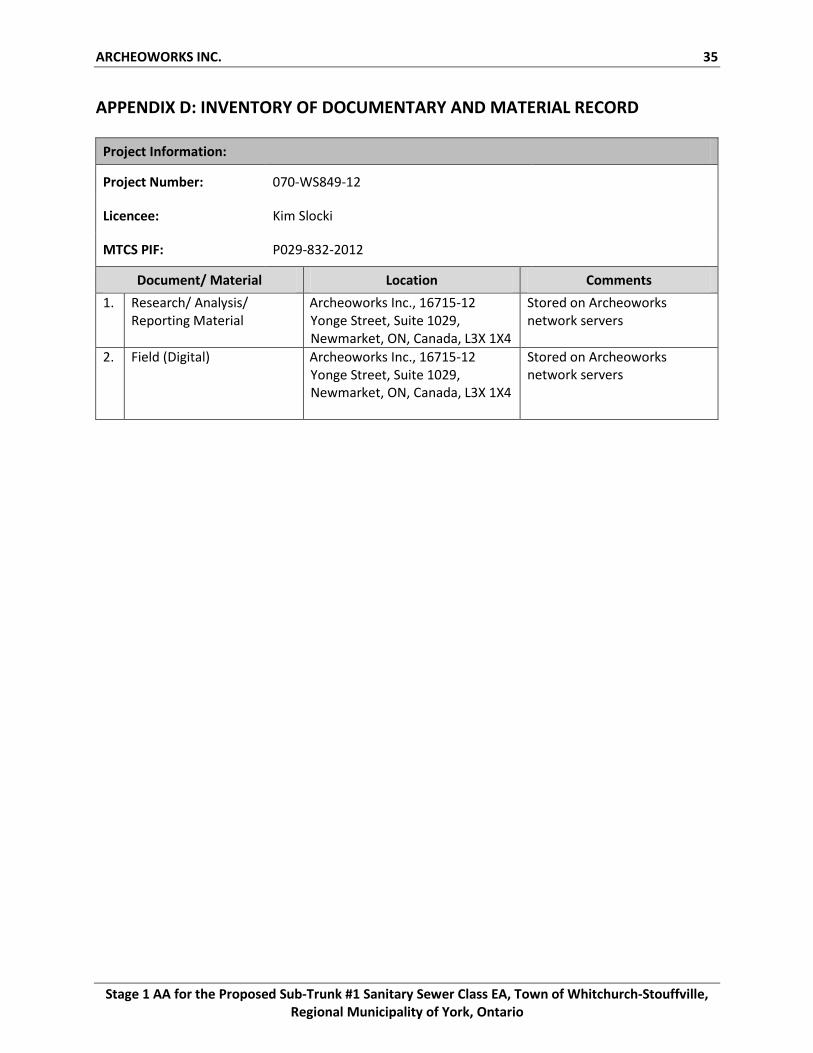
APPENDIX D: INVENTORY OF DOCUMENTARY AND MATERIAL RECORD
Project Information:
Project Number: 070-WS849-12
Licencee: Kim Slocki
MTCS PIF: P029-832-2012
Document/ Material Location Comments
1. Research/ Analysis/ Reporting Material
Archeoworks Inc., 16715-12 Yonge Street, Suite 1029, Newmarket, ON, Canada, L3X 1X4
Stored on Archeoworks network servers
2. Field (Digital) Archeoworks Inc., 16715-12 Yonge Street, Suite 1029, Newmarket, ON, Canada, L3X 1X4
Stored on Archeoworks network servers