Embed Size (px)
Citation preview

SPRINGDALE SOLAR FARM
Further Request for Information (RFI) Report
This document (the “Report”) has been prepared by RES Australia Pty Ltd (“RES”). RES shall not be deemed to make any representation regarding the accuracy, completeness, methodology, reliability or current status of any material contained in this Report, nor does RES assume any liability with respect to any matter or information referred to or contained in the Report, except to the extent specified in (and subject to the terms and conditions of) any contract to which RES is party that relates to the Report (a “Contract”). Any person relying on the Report (a “Recipient”) does so at their own risk, and neither the Recipient nor any person to whom the Recipient provides the Report or any matter or information derived from it shall have any right or claim against RES or any of its affiliated companies in respect thereof, but without prejudice to the terms of any Contract to which the Recipient is party. This Report is confidential and shall only be disclosed to duly authorised Recipients.
Author Steven Reid
Date 1st October 2020
Ref 04317-1602908

2
Revision History
Issue Date Name Latest changes
01 01/10/2020 Steven Reid First Created
02
3
Contents 1 Introduction .............................................................................................................4
1.1 Background .......................................................................................................4
2 Project Further Information ..........................................................................................5
2.1 RFI & proponent response ......................................................................................5
3 Annexures ............................................................................................................... i
3.1 Annexure A – Noise Addendum Report ........................................................................ i
3.2 Annexure B – Viewsheds........................................................................................ ii
3.3 Annexure c – Constraints & Layout Plan ..................................................................... iii
3.4 Annexure D – BDAR Addendum Report & BCD Letter....................................................... iv
3.5 Annexure E – Subdivision Plan .................................................................................. v

4
1 Introduction
1.1 Background
RES Australia Pty Ltd (the proponent) is proposing the construction, operation and decommissioning of the
Springdale Solar Farm near Sutton, NSW (the Project). RES, the world’s largest independent renewable
energy company, announced its acquisition of the Springdale Solar Farm from Renew Estate (the former
proponent) in April 2020.,
The project is classified as State Significant Development (SSD) under the State Environmental Planning
Policy (State and Regional Development) 2011 and requires development consent under Part 4 of the
Environmental Planning and Assessment Act 1979 (EP&A Act). An Environmental Impact Statement (EIS) was
prepared by AECOM Australia Pty Ltd (AECOM) to support the development application and assessed the
environmental and social issues associated with the Project. The EIS was submitted to the DPIE and placed
on public exhibition from 18 July 2018 to 29 August 2018. During the exhibition period, the public and
government agencies were invited to make submissions. Following the close of the exhibition period, the
proponent was required to submit a report detailing responses to issues raised in the received submissions,
as well as provide additional information to support their assessment of the Project.
A Response to Submissions (RtS) was submitted on 31 May 2020. The report sought to address the
requirement that all submissions received are appropriately considered. This RFI report is a record of the
further request for information made by the DPIE following the receipt of the RtS. The report sets out the
further information requested by DPIE, with the proponent’s response and amended project documents,
where necessary.

2 Project Further Information
2.1 RFI & proponent response
DPIE RFI Proponent Response
Assessment of noise and visual impacts on the newly erected building/dwelling located to the north of the project, as well as evidence of consultation undertaken with the landowner;
The proponent has met with the current owner of the new property located near the project’s northern boundary. We have assigned this receiver with the next ‘R’ number from the noise assessment; R35. The noise assessment carried out by AECOM, as part of the original EIS, did not include this noise receiver for the obvious reason, it did not exist. The land on which R35 is located has since been subdivided by the former landowner and sold to a new owner, during the period the Springdale Solar Farm has been live in the State Significant Development process. All relevant information on the project’s layout and noise impacts have been available to the general public. The proponent has updated the noise assessment with an addendum report See Annexure A. A different inverter and revised inverter location was adopted to mitigate the potential noise impacts at R35. The noise threshold of 35bd(A) is no longer exceeded for operational noise.
6
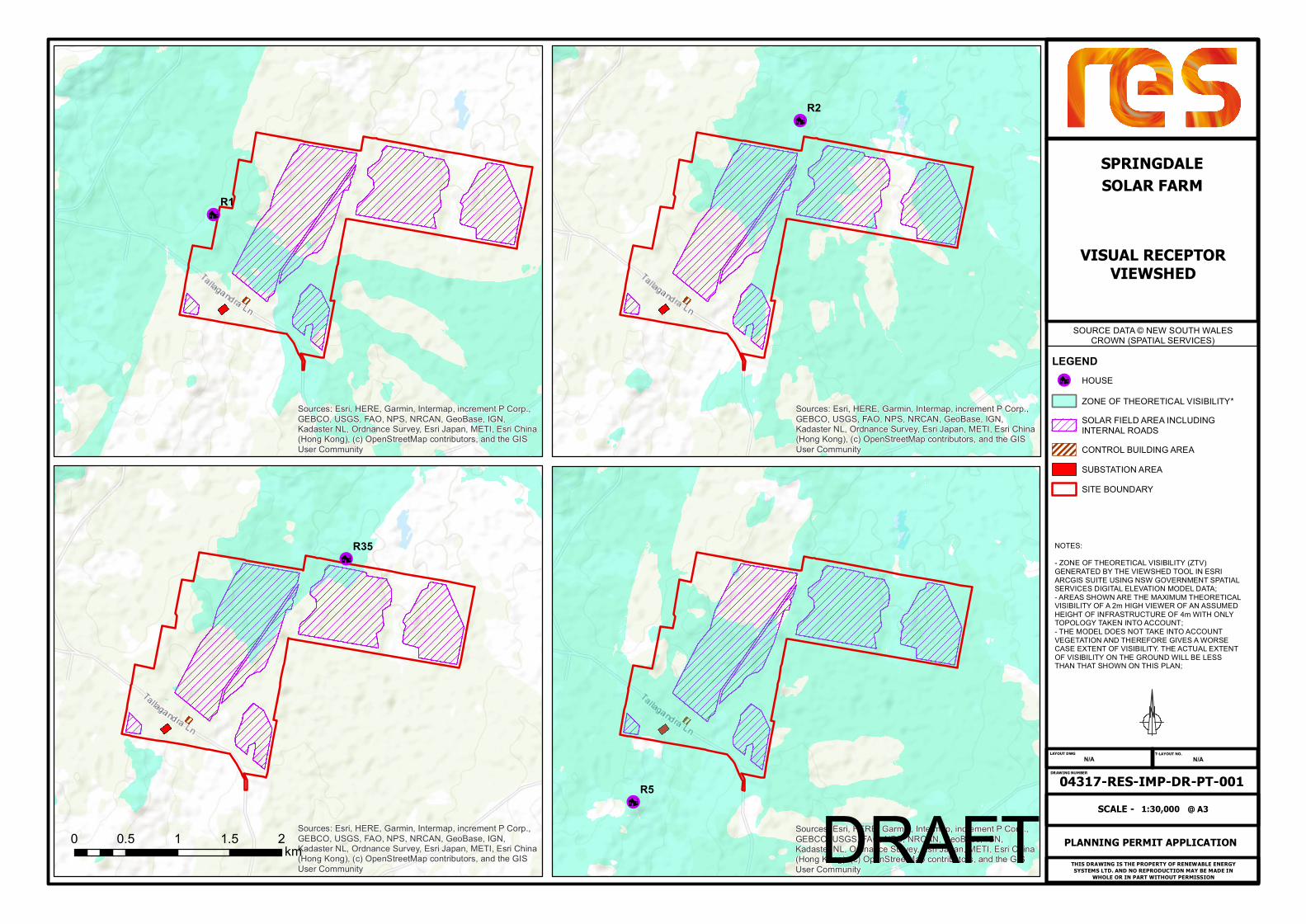
Provide viewsheds from R1, R2, R5 and new dwelling, and confirmation that the Visual Envelope Map in the LVIA is modelled based on topography alone, and not taking intervening vegetation into consideration;
AECOM have confirmed that Figure 2 (Visual envelope map) within the
Landscape and Visual Addendum is a zone of theorical visibility (ZTV)
of the project taken at 1.7 metre eye height,with a 2 km range from
the perimeter of the solar farm applied. That is, areas that are not
shaded on the map are either outside the 2 km buffer or have their
view of the solar farm obstructed by the natural topography (from an
eye height of 1.7 m). Screening by intervening vegetation was not
considered when preparing this map.
Viewsheds have been provided for all 4 requested receptors and are included at Annexure B
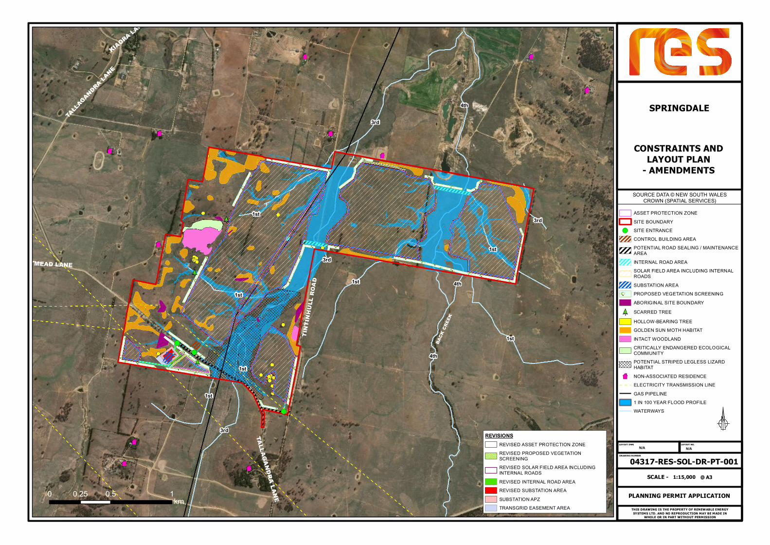
Updates to the Main Constraints map:
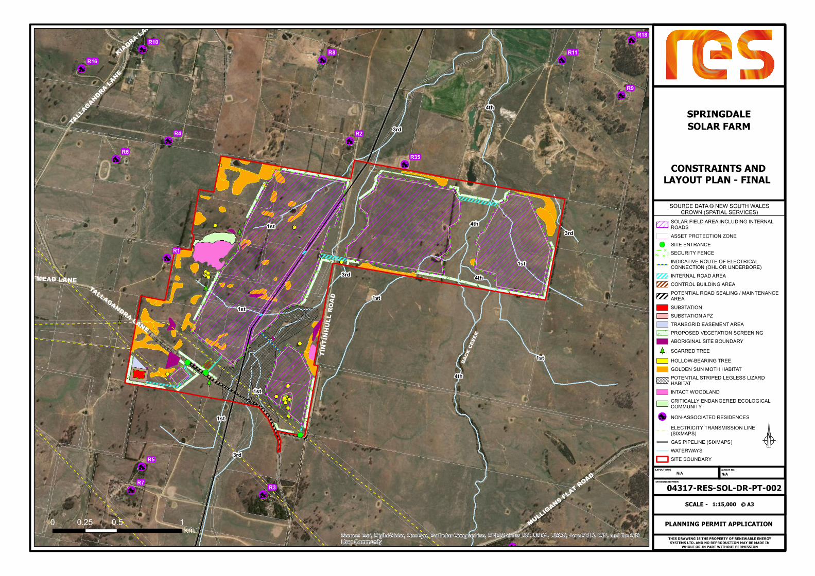
Label residences as per Noise Impact Assessment numbering (eg Gillett is R1, Hassall is R2 etc);
Completed, see revised Constraints plan at Annexure C.
Add security fencing layer; Completed, see revised Constraints plan at Annexure C.
Remove 1 in 100 year flood profile layer; Completed, see revised Constraints plan at Annexure C.
Correct the stream orders and confirm adequate buffer distance on the map (can be done via a text box if easier that in the Legend): Back Creek is 4th order stream; and the unnamed creek is 3rd order stream;
Completed, see revised Constraints plan at Annexure C. The amended stream orders is consistent with Water Management (General) Regulation 2018 Hydro Line spatial data, which is used determine the Strahler stream order. The Project has been developed with a view to maintaining appropriate buffers to all relevant environmental constraints, including waterways. It is noted that, as the Project is SSD, the requirement for an activity approval under section 91 of the Water Management Act 2000 does not apply. This is by virtue of section 4.41 of the Environmental Planning and Assessment Act 1979, which specifies certain authorisations which do not apply to SSD. Following this the Natural Resources Access Regulator’s Guidelines for controlled activities on waterfront land also does not apply. Despite this, the proponent has worked to avoid sensitive riparian areas, particularly those associated with potential threated species habitat, such as Striped Legless Lizard Habitat within the southern portion of the site.

7
Confirm how the SE array section would connect to the substation; The SE array will utilise directional drilling or an OHL avoiding the SLL habitat. This has been updated on the final layout plan at Annexure C.
Confirm the size of the final development footprint;
Final development footprint, including Development Area, tracks, control room and substation is 185Ha. The current optimised layout is based upon 257,634 modules. This is an approximation and the final detailed design will confirm the number of panels to be used.
Clarify traffic movements of OMOD, heavy and light vehicles during construction, and heavy and light vehicles during operation. Noting that a traffic movement is considered entering and exiting; and
The EIS states the following: Construction: 75 daily heavy vehicle movements, 400 daily light vehicle movements and approximately 16 oversized vehicles. It also notes these numbers are based on a single vehicle movement either entering or exiting the site. Considering this, we continue to support the proposed heavy vehicle and light vehicle numbers for the construction period. Converted to the anticipated definition of 1 vehicle movement equating to the vehicle entering and existing site. The numbers would be defined as; 38 daily heavy vehicles movements and 200 daily light vehicle movements. We consider the oversized vehicle movements to be overstated and would propose a change to 3 oversized vehicle movements during construction. Operations: 10 daily light vehicles movements during the first 2 years. Water trucks will be required for panel cleaning when there is less rainfall. This could equate to between 2-3 water trucks per week over the course of a year.
Provide details on the proposed Community Enhancement Fund. The proponent has followed up on the previous proponent’s engagement with Yass Valley Council (YVC). A VPA was proposed by the former proponent. RES is also in favour of a VPA to direct how community funds can be utilised. However, the principle scope of that VPA remains not agreed with YVC. The proponent is keen to see a majority of any earmarked community funds directed to the community in the immediate vicinity of the project and not diluted over the wider community >20k radius. Th proponent has made two offers to YVC for a community benefit fund. The key information for each has been noted below. Please note neither has been accepted by YVC and the proponent will
8
continue to discuss the community benefit fund with YVC to achieve the best outcome for the local community. Option 1: Three categories of payment to be managed within the VPA.
• Road upgrade funds - $500k to be paid at construction commencement for road sealing on Tallagandra Lane.
• Local Community fund - $100k to be paid at construction commencement for community projects within 10km of the solar farm.
• Ongoing Community fund - $10k pa (indexed to cpi) for the 30 year life of the project, from construction commencement for community projects within 20km of the solar farm.
Or
Option 2:
One annual payment to be managed within the VPA.
• $40k pa (indexed to cpi) for the life of the 30 year project, from construction commencement for community projects within 20km of the solar farm. ($500k to be provisioned for road sealing on Tallagandra Lane)
BCD’s Comments on the BDAR submitted with the RTS (see BCD letter). If you could please ensure comments on the BDAR are also addressed in your response.
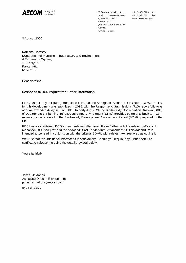
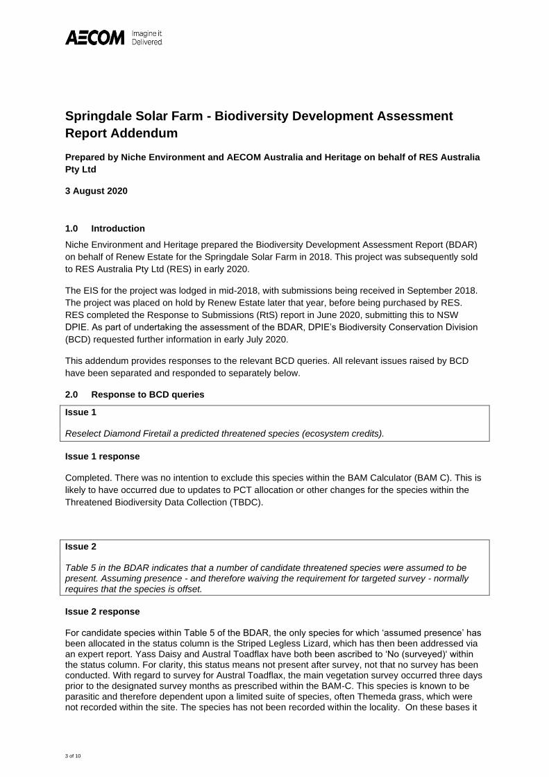
Further discussions between Niche/AECOM and BCD have taken place to clarify the requests made by BCD. The outcome of those discussions has resulted in a BDAR Addendum being provided to reflect the updates and clarifications BCD were seeking. Some of the changes required have been due to the passage of time since the original BDAR was drafted, with changes, during that time, to the definition of habitat as defined by the “Threatened Biodiversity Data Collection”. A copy of the BDAR Addendum is attached at Annexure D. BCD’s original letter has also been included at Annexure D.
Provide a figure showing the proposed subdivision to cater for the substation/switchyard on Lot 209 for inclusion in the development consent;
A revised figure has been drafted to reflect the change in the substation location. The updated subdivision plan now shows the subdivision area as the substation and Asset Protection Zone around the substation in the revised location. The revised plan is attached at Annexure E

9
Explanation as to why the Road Traffic Noise assessment does not include Sutton Road, Bywong Street, Victoria Street and East Tallagandra Lane; and
The noise assessment has been revised to include the construction traffic noise assessment for the entire proposed heavy vehicle construction route. This revised assessment has confirmed no exceedances of the noise thresholds. The addendum to the noise assessment has be attached at Annexure A.
Updated constraints/layout map. In the most recent drawing 04317-RES-SOL-DR-PT-002, the APA gas pipeline easement does not align with the gap between the proposed arrays;
Drawing 04317-RES-SOL-DR-PT-002 has been corrected to show the gas pipe within the gas pipeline easement. This drawing is attached at Annexure C.
Yass Valley Council advised that rather than grading Tallagandra Lane, gravel re-sheeting from the end of the seal to the access locations should occur. Please see if you can resolve this with Council in your discussions next week.
The proponent has agreed to the gravel re-sheeting of the section of Tallagandra Lane from the end of seal to the project access prior to commencement of the construction of the main solar farm.

3 Annexures
3.1 Annexure A – Noise Addendum Report

AECOM Australia Pty LtdLevel 21, 420 George StreetSydney NSW 2000PO Box Q410QVB Post Office NSW 1230Australiawww.aecom.com
+61 2 8934 0000 tel+61 2 8934 0001 faxABN 20 093 846 925
\\ausyd1fp001\projects\605x\60555008\4. tech work area\noise\04_documents\60555008-ltnv-01_c - res update.docx Ref: 60555008-LTNV-01_C
24 August 2020
Steven ReidRES-groupLevel 6, 165 Walker StreetNorth Sydney NSW 2060
Dear Steven,
Springdale Solar Farm - Updated Noise Impact Assessment
1.0 IntroductionAECOM Australia Pty Ltd (AECOM) has been commissioned by RES Australia Pty Ltd (RES) toundertake a noise impact assessment of the proposed Springdale Solar Farm (The Project), located inSutton, NSW.
AECOM has previously undertaken a noise and vibration assessment of the Solar Farm whichconsidered both operational and construction noise (February 2018). Since this assessment somechanges have been proposed to the Project and an additional residential receiver has beenconstructed. This letter provides an update to the operational noise impact assessment and considersthe following:
· New inverters and associated sound power level information
· Updated inverter locations
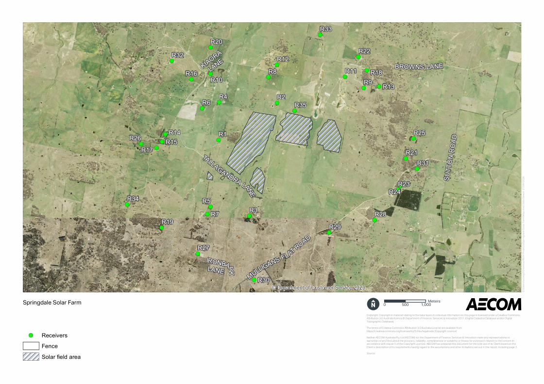
· Additional residential receiver located at 42 Tintinhull Road, Sutton (R35 in Figure 1 below).
Additional information is also provided for the construction road traffic noise assessment.

AECOM Australia Pty LtdLevel 21, 420 George StreetSydney NSW 2000PO Box Q410QVB Post Office NSW 1230Australiawww.aecom.com
+61 2 8934 0000 tel+61 2 8934 0001 faxABN 20 093 846 925
\\ausyd1fp001\projects\605x\60555008\4. tech work area\noise\04_documents\60555008-ltnv-01_c - res update.docx Ref: 60555008-LTNV-01_C
Figure 1 Site Map and receivers

AECOM Australia Pty LtdLevel 21, 420 George StreetSydney NSW 2000PO Box Q410QVB Post Office NSW 1230Australiawww.aecom.com
+61 2 8934 0000 tel+61 2 8934 0001 faxABN 20 093 846 925
\\ausyd1fp001\projects\605x\60555008\4. tech work area\noise\04_documents\60555008-ltnv-01_c - res update.docx Ref: 60555008-LTNV-01_C
2.0 Operational noise2.1 Operational noise trigger levelsThe operational noise trigger levels were presented in the previous AECOM report of February 2018.A summary of the noise trigger levels for the Project is presented in Table 1. Given the nature of theoperation of a solar farm, only the day and evening time noise criteria are applicable. Equipment wouldnot be in use during the night-time period, therefore the evening period is considered to represent theworst case operational noise scenario.Table 1 Project specific noise levels, dB(A)
Receiver area Period1 RBL(LA90, 15 min)
Intrusivecriterion(LAeq, 15 min)
Amenitycriterion(LAeq, Period)
Project noisetrigger levels,(LAeq)2
All nearbyresidentialreceivers
Day 35 40 50 40
Evening 30 35 45 35
Night 30 35 40 35Notes:
1. Day is defined as 7:00 am to 6:00 pm, Monday to Saturday and 8:00 am to 6:00 pm Sundays & Public Holidays.Evening is defined as 6:00 pm to 10:00 pm, Monday to Sunday & Public Holidays. Night is defined as 10:00 pm to7:00 am, Monday to Saturday and 10:00 pm to 8:00 am Sundays & Public Holidays.
2. Project specific noise levels determined as the lowest of the intrusive and amenity criteria.
2.2 Operational noise assessment2.2.1 Noise sourcesA list of operational noise sources is presented in Table 2 below. RES has advised that the Projectwould be operational during the daytime, every day of the year and is anticipated to be manned from7am to 6pm on these days. Operational and maintenance activities may occasionally occur beyonddaylight hours for minor corrective and preventative maintenance activities.
The assessed items of equipment are presumed to be steady noise sources, as such the LAeq and LA1noise levels are assumed to be equivalent.

\\ausyd1fp001\projects\605x\60555008\4. tech work area\noise\04_documents\60555008-ltnv-01_c - res update.docx2 of 8
Table 2 Springdale Solar Farm operational noise sources
Equipment SWL, dB(A) Quantity DescriptionInverter/transformer DC side - 881
AC side - 981~20 x 2 · 2 inverters units per power station
container.· The operating capacity of the
inverter is likely to vary during theday with maximum capacityoccurring during the day
· Inverter noise is directional with theAC side being 10 dB louder thanthe DC side. 1
Trackers 78 ~3,000 · Assumed to operate no more than1 minute out of every 15 minutes
Internal light vehiclemovements
90 ~2 per day · It is assumed the site would bechecked daily by a two personcrew.
Substation 75 1 -Notes:
1. Sound power level as per sound pressure measurements of a HEMK inverter unit as detailed in the Technical Report –Sound Pressure Level in FREEMAQ PCSK/FREESUN HEMK Inverters, April 2020.
2.2.2 Noise modelling methodologyNoise levels due to the equipment shown in Table 2 have been predicted at nearby noise sensitivereceivers using SoundPLAN 8.0 (industry standard) noise modelling software. The CONCAWEmethod was used for the operational noise modelling.
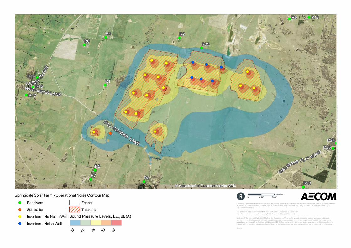
2.2.3 Operational modelling assumptionsThe following assumptions have been made in modelling all operational noise scenarios:
· All equipment would be operating simultaneously
· Adverse weather conditions
· Equipment locations are as shown in the site layout plan in the Appendix
· 2 metre high “horse-shoe” shaped noise walls around specific inverter units as indicated in thelayout plan.
2.2.4 Predicted operational noise levelsPredicted noise levels at nearby noise sensitive receivers are presented in Table 3. The predictednoise levels are assessed against the more stringent evening time trigger level. It is noted thatalthough the sound power spectrum of the inverters is tonal, the predicted sound spectrum at thenearest receivers is not tonal; therefore no modifying factor has been applied.
Operational noise contours calculated at 1.5 m above ground are provided in the Appendix. Thesecontours are indicative only and should not be referred to for noise levels at specific receiver locations.Operational noise levels and contours which are presented have been calculated under adverseweather conditions.
Any significant variations to the above modelling assumptions will require a reassessment.
\\ausyd1fp001\projects\605x\60555008\4. tech work area\noise\04_documents\60555008-ltnv-01_c - res update.docx3 of 8
Table 3 Predicted operational noise levels under adverse weather conditions (evening)
Receiver Predicted LAeq noiselevels, dB(A)
Operational noisetrigger level, LAeqdB(A)
Exceedance, dB(A)
R1 31 35 -R2 32 35 -R3 28 35 -R4 22 35 -R5 26 35 -R6 21 35 -R7 18 35 -R8 25 35 -R9 24 35 -R10 20 35 -R11 24 35 -R12 20 35 -R13 22 35 -R14 20 35 -R15 20 35 -R16 19 35 -R17 20 35 -R18 21 35 -R19 17 35 -R20 17 35 -R21 27 35 -R22 20 35 -R23 27 35 -R24 27 35 -R25 13 35 -R26 17 35 -R27 18 35 -R28 14 35 -R29 28 35 -R30 20 35 -R31 21 35 -R32 7 35 -R33 19 35 -R34 15 35 -R35 35 35 -
Notes:
1. Day is defined as 7:00 am to 6:00 pm, Monday to Saturday and 8:00 am to 6:00 pm Sundays & Public Holidays.Evening is defined as 6:00 pm to 10:00 pm, Monday to Sunday & Public Holidays. Night is defined as 10:00 pm to7:00 am, Monday to Saturday and 10:00 pm to 8:00 am Sundays & Public Holidays.
2.2.5 Discussion of resultsResults show predicted operational noise emissions from the Project comply with the most stringent(evening time) operational noise trigger levels at all locations. It is expected that the inverters (which

\\ausyd1fp001\projects\605x\60555008\4. tech work area\noise\04_documents\60555008-ltnv-01_c - res update.docx4 of 8
are the dominant noise sources), would operate at a reduced load in the evening compared to duringthe daytime and as such the noise emission levels would also be reduced further from the modelledresults presented here.
It is recommended that the trackers are properly maintained by the solar farm operator to ensure thatthe noise emission of the trackers is not adversely affected by wear.
3.0 Construction road traffic noise3.1 Road traffic noise criteriaNoise from construction traffic on public roads is not covered by the Interim Construction NoiseGuideline (ICNG). However, the ICNG does refer to the Environmental Criteria for Road Traffic Noise(ECRTN), now superseded by the Road Noise Policy (RNP), for the assessment of noise arising fromconstruction traffic on public roads.
In accordance with the RNP, to assess noise impacts from construction traffic, an initial screening testshould be undertaken by evaluating whether existing road traffic noise levels will increase by morethan 2 dB(A). Where the predicted noise increase is 2 dB(A) or less, then no further assessment isrequired. However, where the predicted noise level increase is greater than 2 dB(A), and the predictedroad traffic noise level exceeds the road category specific criterion then noise mitigation should beconsidered for those receivers affected. The road category specific criteria are presented in Table 4below. The RNP does not require assessment of noise impact to commercial or industrial receivers.Table 4 Road traffic noise assessment criteria
Road category Type of land useAssessment criteria, dB(A)Day (7 am –10 pm)
Night (10 pm –7 am)
Freeway/arterial/sub-arterial roads
Existing residences affected byadditional traffic on existingfreeways/arterial/sub-arterial roadsgenerated by land use developments
LAeq(15 hour)60 dB(A)
LAeq(9 hour)55 dB(A)
Local roads Existing residences affected byadditional traffic on existing local roadsgenerated by land use developments
LAeq(1 hour)55 dB(A)
LAeq(1 hour)50 dB(A)
3.2 Construction road traffic noise assessmentThe construction traffic route is as follows after leaving the Federal Highway:
· Sutton Road (Arterial Road)
· Bywong Street (Arterial Road)
· Victoria Street (Arterial Road)
· Camp Street (Arterial Road)
· Leaving the Sutton township on Sutton Road (Arterial Road)
· East Tallagandra Lane (Sub-arterial Road)
· Mulligans Flat Road (Sub-arterial Road)
· Tallagandra Lane (Local Road).
As part of its Asset Management Program Yass Valley Council conducts traffic counts around theYass Valley Local Government Area and these data have been used to provide an analysis of existingtraffic volumes for roads proposed to be used by construction traffic.
\\ausyd1fp001\projects\605x\60555008\4. tech work area\noise\04_documents\60555008-ltnv-01_c - res update.docx5 of 8
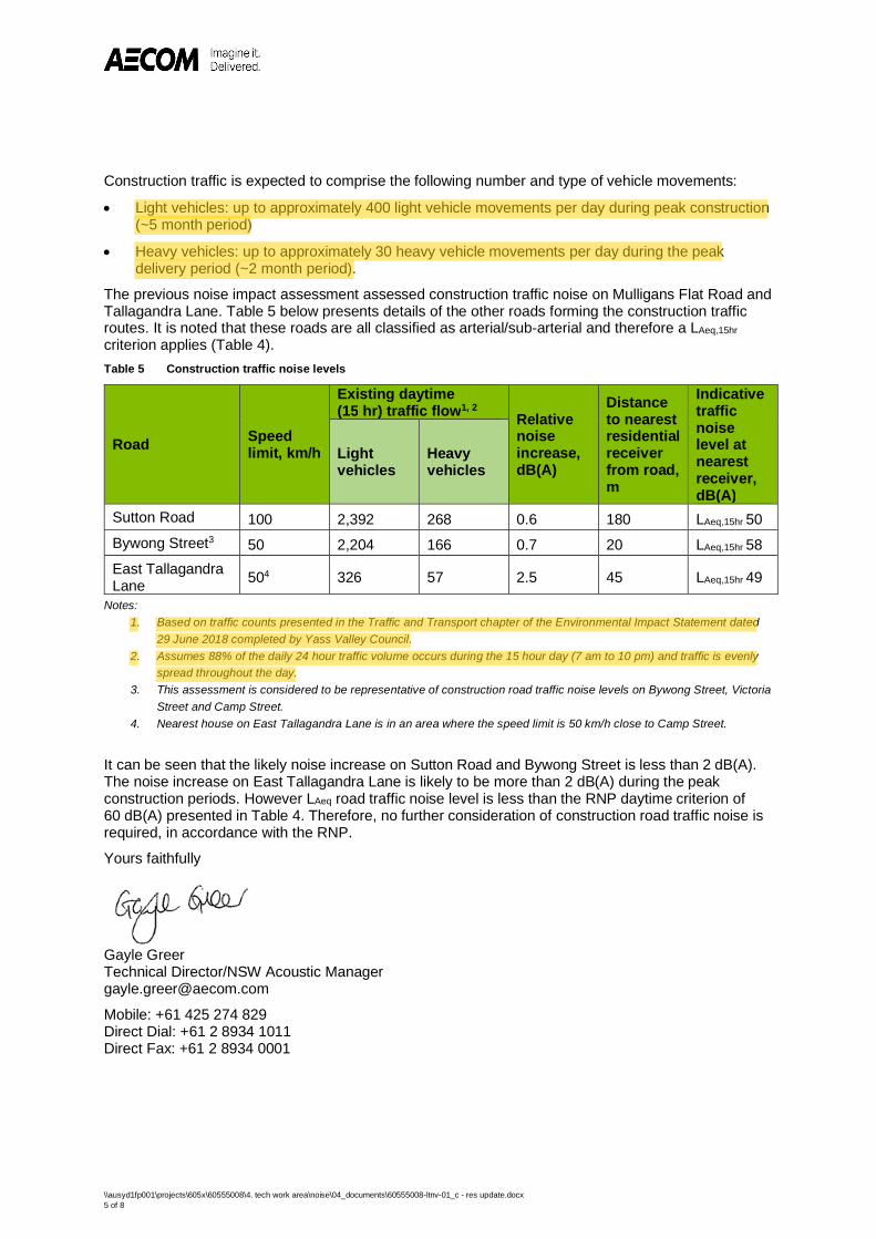
Construction traffic is expected to comprise the following number and type of vehicle movements:
· Light vehicles: up to approximately 400 light vehicle movements per day during peak construction(~5 month period)
· Heavy vehicles: up to approximately 30 heavy vehicle movements per day during the peakdelivery period (~2 month period).
The previous noise impact assessment assessed construction traffic noise on Mulligans Flat Road andTallagandra Lane. Table 5 below presents details of the other roads forming the construction trafficroutes. It is noted that these roads are all classified as arterial/sub-arterial and therefore a LAeq,15hrcriterion applies (Table 4).Table 5 Construction traffic noise levels
Road Speedlimit, km/h
Existing daytime(15 hr) traffic flow1, 2
Relativenoiseincrease,dB(A)
Distanceto nearestresidentialreceiverfrom road,m
Indicativetrafficnoiselevel atnearestreceiver,dB(A)
Lightvehicles
Heavyvehicles
Sutton Road 100 2,392 268 0.6 180 LAeq,15hr 50Bywong Street3 50 2,204 166 0.7 20 LAeq,15hr 58East TallagandraLane 504 326 57 2.5 45 LAeq,15hr 49
Notes:1. Based on traffic counts presented in the Traffic and Transport chapter of the Environmental Impact Statement dated
29 June 2018 completed by Yass Valley Council.2. Assumes 88% of the daily 24 hour traffic volume occurs during the 15 hour day (7 am to 10 pm) and traffic is evenly
spread throughout the day.3. This assessment is considered to be representative of construction road traffic noise levels on Bywong Street, Victoria
Street and Camp Street.4. Nearest house on East Tallagandra Lane is in an area where the speed limit is 50 km/h close to Camp Street.
It can be seen that the likely noise increase on Sutton Road and Bywong Street is less than 2 dB(A).The noise increase on East Tallagandra Lane is likely to be more than 2 dB(A) during the peakconstruction periods. However LAeq road traffic noise level is less than the RNP daytime criterion of60 dB(A) presented in Table 4. Therefore, no further consideration of construction road traffic noise isrequired, in accordance with the RNP.
Yours faithfully
Gayle GreerTechnical Director/NSW Acoustic [email protected]
Mobile: +61 425 274 829Direct Dial: +61 2 8934 1011Direct Fax: +61 2 8934 0001

\\ausyd1fp001\projects\605x\60555008\4. tech work area\noise\04_documents\60555008-ltnv-01_c - res update.docx6 of 8
Appendix
!(!(!(
!(
!(
!(!(
!(
!(
!(
!(
!(
!(
!(
!(!(
!( !(
!(
!(
!(
!(
!(
!(
!(
!(
!(
!(
!(
!(
!(
!(
!(
!(
!(
SUTT
ON R
OAD
TALLAGANDRA LANEMULLIGANS FLAT ROAD
BROWNS LANEKIAORA
LANE
IRONBARKLANE
R15R26R17
R7
R10R13R9
R2
R28R29
R22
R25
R21
R23
R6 R4
R16 R8R12
R11
R3R5
R14
R32R20
R33
R18
R31
R24
R30
R27
R19
R34
R1
R35
© Department of Customer Service 2020
Springdale Solar Farm
!( ReceiversFenceSolar field area
C:\
Us
ers
\lu
ca
sg
2\D
es
kto
p\W
AH
Pro
jec
ts\S
pri
ng
da
le S
ola
r F
arm
\Ma
p.m
xd D
ate
Sa
ved
: 31
/07
/20
20
Co pyright: Co pyright in mat e rial r e latin g to the base laye rs (co n t e xt u al in fo rmatio n ) o n this page is lice n se d u n de r a Cre ative Co mmo n s,
Att ribu tio n 3.0 Au st ralia lice n ce © De par tme n t o f Fin an ce , Se rvice s & In n o vatio n 2017, (Digital Cadastral Database an d/o r Digital
To po graphic Database ).
The t e rms o f Cr e ative Co mmo n s Att ribu tio n 3.0 Au st ralia Lice n se ar e available fr o m
ht tps://cre ative co mmo n s.o rg/lice n se s/by/3.0/au /le galco de (Co pyright Lice n ce )
Ne ithe r AECOM Au st ralia Pty Ltd (AECOM) n o r the De par tme n t o f Fin an ce , Se rvice s & In n o vatio n make an y r e pr e se n tatio n s o r
war ran tie s o f an y kin d, abo u t the accu racy, r e liability, co mple t e n e ss o r su itabilit y o r fitn e ss fo r pu rpo se in r e latio n t o the co n t e n t (inacco rdan ce with clau se 5 o f the Co pyright Lice n ce ). AECOM has pre par e d this do cu me n t fo r the so le u se o f its Clie n t base d o n the
Clie n t’s de scriptio n o f its r e qu ir e me n ts havin g r e gard to the assu mptio n s an d o the r limitatio n s se t o u t in this r e po r t, in clu din g page 2.
Source:
0 500 1,000Meters

!(
!(
!(
!(
!(
!(!(
!(!(
!(
!(
!(!(
!(
!(
!(!(
!(
!(
!(!(
!(
!(
!(!(
!(
!(
!(
!(
!(
!(
!(
!(
!(
!(
!(
!(
TALLAGANDRA LANE
WESTMEAD LANE
MULLIGANS FLAT ROAD
CAS EY CLOS
E
R15R17
R7
R13R9
R2
R28
R23
R6R4
R3
R5
R14
R24
R1
R35
© Department of Customer Service 2020
Springdale Solar Farm
!( Substation!( Receivers!( Inverters - No Noise Wall!( Inverters - Noise Wall
FenceSolar field area
C:\
Us
ers
\lu
ca
sg
2\D
es
kto
p\W
AH
Pro
jec
ts\S
pri
ng
da
le S
ola
r F
arm
\Ba
rrie
r_M
ap
.mx
d D
ate
Sa
ve
d: 3
1/0
7/2
02
0
Co pyright: Co pyright in mat e rial r e latin g to the base laye rs (co n t e xt u al in fo rmatio n ) o n this page is lice n se d u n de r a Cre ative Co mmo n s,
Att ribu tio n 3.0 Au st ralia lice n ce © De par tme n t o f Fin an ce , Se rvice s & In n o vatio n 2017, (Digital Cadastral Database an d/o r Digital
To po graphic Database ).
The t e rms o f Cr e ative Co mmo n s Att ribu tio n 3.0 Au st ralia Lice n se ar e available fr o m
ht tps://cre ative co mmo n s.o rg/lice n se s/by/3.0/au /le galco de (Co pyright Lice n ce )
Ne ithe r AECOM Au st ralia Pty Ltd (AECOM) n o r the De par tme n t o f Fin an ce , Se rvice s & In n o vatio n make an y r e pr e se n tatio n s o r
war ran tie s o f an y kin d, abo u t the accu racy, r e liability, co mple t e n e ss o r su itabilit y o r fitn e ss fo r pu rpo se in r e latio n t o the co n t e n t (inacco rdan ce with clau se 5 o f the Co pyright Lice n ce ). AECOM has pre par e d this do cu me n t fo r the so le u se o f its Clie n t base d o n the
Clie n t’s de scriptio n o f its r e qu ir e me n ts havin g r e gard to the assu mptio n s an d o the r limitatio n s se t o u t in this r e po r t, in clu din g page 2.
Source:
0 250 500Meters
!(
!(
!(
!(
!(
!(!(
!(!(
!(
!(
!(!(
!(
!(
!(!(
!(
!(
!(!(
!(
!(
!(!(
!(
!(
!(
!(
!(
!(
!(
!(
!(
!(
!(
!(
R15R17
R7
R13R9
R2
R28
R23
R6R4
R3
R5
R14
R24
R1
R35
TALLAGANDRA LANE
WESTMEAD LANE
MULLIGANS FLAT ROAD
CAS EY CLOS
E
© Department of Customer Service 2020
Springdale Solar Farm - Operational Noise Contour Map
!( Receivers!( Substation!( Inverters - No Noise Wall!( Inverters - Noise Wall
FenceTrackers
Sound Pressure Levels, LAeq dB(A)
35 40 45 50 55
C:\
Us
ers
\lu
ca
sg
2\D
es
kto
p\W
AH
Pro
jec
ts\S
pri
ng
da
le S
ola
r F
arm
\No
ise
_Co
nto
urs
.mx
d D
ate
Sa
ve
d: 3
1/0
7/2
02
0
Co pyright: Co pyright in mat e rial r e latin g to the base laye rs (co n t e xt u al in fo rmatio n ) o n this page is lice n se d u n de r a Cre ative Co mmo n s,
Att ribu tio n 3.0 Au st ralia lice n ce © De par tme n t o f Fin an ce , Se rvice s & In n o vatio n 2017, (Digital Cadastral Database an d/o r Digital
To po graphic Database ).
The t e rms o f Cr e ative Co mmo n s Att ribu tio n 3.0 Au st ralia Lice n se ar e available fr o m
ht tps://cre ative co mmo n s.o rg/lice n se s/by/3.0/au /le galco de (Co pyright Lice n ce )
Ne ithe r AECOM Au st ralia Pty Ltd (AECOM) n o r the De par tme n t o f Fin an ce , Se rvice s & In n o vatio n make an y r e pr e se n tatio n s o r
war ran tie s o f an y kin d, abo u t the accu racy, r e liability, co mple t e n e ss o r su itabilit y o r fitn e ss fo r pu rpo se in r e latio n t o the co n t e n t (inacco rdan ce with clau se 5 o f the Co pyright Lice n ce ). AECOM has pre par e d this do cu me n t fo r the so le u se o f its Clie n t base d o n the
Clie n t’s de scriptio n o f its r e qu ir e me n ts havin g r e gard to the assu mptio n s an d o the r limitatio n s se t o u t in this r e po r t, in clu din g page 2.
Source:
0 250 500Meters

ii
3.2 Annexure B – Viewsheds
THIS DRAWING IS THE PROPERTY OF RENEWABLE ENERGYSYSTEMS LTD. AND NO REPRODUCTION MAY BE MADE IN
WHOLE OR IN PART WITHOUT PERMISSION
LAYOUT DWG T-LAYOUT NO.
DRAWING NUMBER
!jR5
Sources: Esri, HERE, Garmin, Intermap, increment P Corp.,GEBCO, USGS, FAO, NPS, NRCAN, GeoBase, IGN,Kadaster NL, Ordnance Survey, Esri Japan, METI, Esri China(Hong Kong), (c) OpenStreetMap contributors, and the GISUser Community
04317-RES-IMP-DR-PT-001N/AN/A
PLANNING PERMIT APPLICATION
1:30,000SCALE - @ A3DRAFT
SPRINGDALE
VISUAL RECEPTORVIEWSHED
SOLAR FARM
SOURCE DATA © NEW SOUTH WALESCROWN (SPATIAL SERVICES)
!jR1
Sources: Esri, HERE, Garmin, Intermap, increment P Corp.,GEBCO, USGS, FAO, NPS, NRCAN, GeoBase, IGN,Kadaster NL, Ordnance Survey, Esri Japan, METI, Esri China(Hong Kong), (c) OpenStreetMap contributors, and the GISUser Community
!jR35
Sources: Esri, HERE, Garmin, Intermap, increment P Corp.,GEBCO, USGS, FAO, NPS, NRCAN, GeoBase, IGN,Kadaster NL, Ordnance Survey, Esri Japan, METI, Esri China(Hong Kong), (c) OpenStreetMap contributors, and the GISUser Community
!jR2
Sources: Esri, HERE, Garmin, Intermap, increment P Corp.,GEBCO, USGS, FAO, NPS, NRCAN, GeoBase, IGN,Kadaster NL, Ordnance Survey, Esri Japan, METI, Esri China(Hong Kong), (c) OpenStreetMap contributors, and the GISUser Community
NOTES:- ZONE OF THEORETICAL VISIBILITY (ZTV)GENERATED BY THE VIEWSHED TOOL IN ESRIARCGIS SUITE USING NSW GOVERNMENT SPATIALSERVICES DIGITAL ELEVATION MODEL DATA;- AREAS SHOWN ARE THE MAXIMUM THEORETICALVISIBILITY OF A 2m HIGH VIEWER OF AN ASSUMEDHEIGHT OF INFRASTRUCTURE OF 4m WITH ONLYTOPOLOGY TAKEN INTO ACCOUNT;- THE MODEL DOES NOT TAKE INTO ACCOUNTVEGETATION AND THEREFORE GIVES A WORSECASE EXTENT OF VISIBILITY. THE ACTUAL EXTENTOF VISIBILITY ON THE GROUND WILL BE LESSTHAN THAT SHOWN ON THIS PLAN;
0 0.5 1 1.5 2km
LEGEND!j HOUSE
ZONE OF THEORETICAL VISIBILITY*SOLAR FIELD AREA INCLUDINGINTERNAL ROADSCONTROL BUILDING AREASUBSTATION AREASITE BOUNDARY

iii
3.3 Annexure c – Constraints & Layout Plans
!(
!(
!(
oo
oo
oo
4th
3rd
1st
4th
1st
1st
3rd
3rd
1st
1st
4th
3rd
1st
1st
TALL
AGANDRA LANE
MULLIGANS FLAT ROAD
TALLAGANDRA LANE
KIAORA LANE
WESTMEAD LANE
Source: Esri, DigitalGlobe, GeoEye, Earthstar Geographics, CNES/Airbus DS, USDA, USGS, AeroGRID, IGN, and the GISUser Community
CONSTRAINTS ANDLAYOUT PLAN
- AMENDMENTS
04317-RES-SOL-DR-PT-001N/AN/A
PLANNING PERMIT APPLICATION
1:15,000SCALE - @ A3
SOURCE DATA © NEW SOUTH WALESCROWN (SPATIAL SERVICES)
SPRINGDALE
THIS DRAWING IS THE PROPERTY OF RENEWABLE ENERGYSYSTEMS LTD. AND NO REPRODUCTION MAY BE MADE IN
WHOLE OR IN PART WITHOUT PERMISSION
LAYOUT DWG
DRAWING NUMBER
LAYOUT NO.
0 0.5 10.25km
ASSET PROTECTION ZONESITE BOUNDARY
!( SITE ENTRANCECONTROL BUILDING AREAPOTENTIAL ROAD SEALING / MAINTENANCEAREAINTERNAL ROAD AREASOLAR FIELD AREA INCLUDING INTERNALROADSSUBSTATION AREAPROPOSED VEGETATION SCREENINGABORIGINAL SITE BOUNDARY
oo SCARRED TREEHOLLOW-BEARING TREEGOLDEN SUN MOTH HABITATINTACT WOODLANDCRITICALLY ENDANGERED ECOLOGICALCOMMUNITYPOTENTIAL STRIPED LEGLESS LIZARDHABITAT
88 NON-ASSOCIATED RESIDENCEELECTRICITY TRANSMISSION LINEGAS PIPELINE1 IN 100 YEAR FLOOD PROFILEWATERWAYS
TINT
INHU
LL R
OAD
REVISIONSREVISED ASSET PROTECTION ZONEREVISED PROPOSED VEGETATIONSCREENINGREVISED SOLAR FIELD AREA INCLUDINGINTERNAL ROADSREVISED INTERNAL ROAD AREAREVISED SUBSTATION AREASUBSTATION APZTRANSGRID EASEMENT AREA
BACK
CRE
EK
!(
!(
!(
oo
oo
oo
[
[
[
[
[
[
[
[
[
[
[
[
[
[[
[
[
[
[
[
[[
[[
[
[[
[[
[
[
[
[
[
[
[
[
[
[
[
[
[
[
[
[
[[
[[
[
[
[[
[
[
[
[
[
[
[
[ [[
[ [
[ [
[[
[
[[
[
[
[[
[[
[[
[[
[
[
[
[[
[
[
[
[
[ [
[
[
[
[
[[
[[
[[
[[
[
[[
[[
[
[
[
[
[
[
[
[
[
[
[[
[
[
4th
4th
4th
3rd
1st
4th
1st
3rd
3rd
1st
1st
1st
3rd
1st
1st
R3
R9
R7
R5
R2
R8
R4
R6
R1
R18
R16
R10
R35
R11
TALLAGANDRA LANE
MULLIGANS FLAT ROAD
TALL
AGANDRA LANE
KIAORA LANE
WESTMEAD LANE
Source: Esri, DigitalGlobe, GeoEye, Earthstar Geographics, CNES/Airbus DS, USDA, USGS, AeroGRID, IGN, and the GISUser Community
CONSTRAINTS ANDLAYOUT PLAN - FINAL
04317-RES-SOL-DR-PT-002N/AN/A
PLANNING PERMIT APPLICATION
1:15,000SCALE - @ A3
SOURCE DATA © NEW SOUTH WALESCROWN (SPATIAL SERVICES)
SPRINGDALE
THIS DRAWING IS THE PROPERTY OF RENEWABLE ENERGYSYSTEMS LTD. AND NO REPRODUCTION MAY BE MADE IN
WHOLE OR IN PART WITHOUT PERMISSION
LAYOUT DWG
DRAWING NUMBER
LAYOUT NO.
0 0.5 10.25km
SOLAR FIELD AREA INCLUDING INTERNALROADSASSET PROTECTION ZONE
!( SITE ENTRANCE
[
[
[ SECURITY FENCEINDICATIVE ROUTE OF ELECTRICALCONNECTION (OHL OR UNDERBORE)INTERNAL ROAD AREACONTROL BUILDING AREAPOTENTIAL ROAD SEALING / MAINTENANCEAREASUBSTATIONSUBSTATION APZTRANSGRID EASEMENT AREAPROPOSED VEGETATION SCREENINGABORIGINAL SITE BOUNDARY
oo SCARRED TREEHOLLOW-BEARING TREEGOLDEN SUN MOTH HABITATPOTENTIAL STRIPED LEGLESS LIZARDHABITATINTACT WOODLANDCRITICALLY ENDANGERED ECOLOGICALCOMMUNITY
!> NON-ASSOCIATED RESIDENCESELECTRICITY TRANSMISSION LINE(SIXMAPS)GAS PIPELINE (SIXMAPS)WATERWAYSSITE BOUNDARY
TINT
INHU
LL R
OAD
BACK
CRE
EK
SOLAR FARM

iv
3.4 Annexure D – BDAR Addendum Report & BCD Letter
AECOM Australia Pty Ltd
Level 21, 420 George Street
Sydney NSW 2000
PO Box Q410
QVB Post Office NSW 1230
Australia
www.aecom.com
+61 2 8934 0000 tel
+61 2 8934 0001 fax
ABN 20 093 846 925
3 August 2020
Natasha Homsey Department of Planning, Infrastructure and Environment 4 Parramatta Square, 12 Darcy St, Parramatta NSW 2150
Dear Natasha,
Response to BCD request for further information
RES Australia Pty Ltd (RES) propose to construct the Springdale Solar Farm in Sutton, NSW. The EIS for this development was submitted in 2018, with the Response to Submissions (RtS) report following after an extended delay in June 2020. In early July 2020 the Biodiversity Conservation Division (BCD) of Department of Planning, Infrastructure and Environment (DPIE) provided comments back to RES regarding specific detail of the Biodiversity Development Assessment Report (BDAR) prepared for the EIS.
RES has now reviewed BCD’s comments and discussed these further with the relevant officers. In response, RES has provided the attached BDAR Addendum (Attachment 1). This addendum is intended to be read in conjunction with the original BDAR, with relevant text replaced as outlined.
We trust that this additional information is satisfactory. Should you require any further detail or clarification please me using the detail provided below.
Yours faithfully Jamie McMahon Associate Director Environment [email protected]
0424 843 870

2 of 10
Attachment 1: Springdale Solar Farm BDAR Addendum
3 of 10
Springdale Solar Farm - Biodiversity Development Assessment
Report Addendum
Prepared by Niche Environment and AECOM Australia and Heritage on behalf of RES Australia
Pty Ltd
3 August 2020
1.0 Introduction
Niche Environment and Heritage prepared the Biodiversity Development Assessment Report (BDAR)
on behalf of Renew Estate for the Springdale Solar Farm in 2018. This project was subsequently sold
to RES Australia Pty Ltd (RES) in early 2020.
The EIS for the project was lodged in mid-2018, with submissions being received in September 2018.
The project was placed on hold by Renew Estate later that year, before being purchased by RES.
RES completed the Response to Submissions (RtS) report in June 2020, submitting this to NSW
DPIE. As part of undertaking the assessment of the BDAR, DPIE’s Biodiversity Conservation Division
(BCD) requested further information in early July 2020.
This addendum provides responses to the relevant BCD queries. All relevant issues raised by BCD
have been separated and responded to separately below.
2.0 Response to BCD queries
Issue 1
Reselect Diamond Firetail a predicted threatened species (ecosystem credits).
Issue 1 response
Completed. There was no intention to exclude this species within the BAM Calculator (BAM C). This is
likely to have occurred due to updates to PCT allocation or other changes for the species within the
Threatened Biodiversity Data Collection (TBDC).
Issue 2 Table 5 in the BDAR indicates that a number of candidate threatened species were assumed to be present. Assuming presence - and therefore waiving the requirement for targeted survey - normally requires that the species is offset.
Issue 2 response For candidate species within Table 5 of the BDAR, the only species for which ‘assumed presence’ has been allocated in the status column is the Striped Legless Lizard, which has then been addressed via an expert report. Yass Daisy and Austral Toadflax have both been ascribed to ‘No (surveyed)‘ within the status column. For clarity, this status means not present after survey, not that no survey has been conducted. With regard to survey for Austral Toadflax, the main vegetation survey occurred three days prior to the designated survey months as prescribed within the BAM-C. This species is known to be parasitic and therefore dependent upon a limited suite of species, often Themeda grass, which were not recorded within the site. The species has not been recorded within the locality. On these bases it
4 of 10
is clear that the preferred habitat of the species is not present at the site and therefore it is considered absent. Issue 2 (cont.): However, the information in the BAM C in relation to candidate threatened species is
inconsistent with Table 5 in the BDAR. For example, both Yass Daisy and Austral Toadflax have been
deselected as Candidate Threatened Species in the BAM C, indicating that further assessment is not
required, but Table 5 in the BDAR indicates that both species were surveyed. Candidate species can
only be removed where habitat constraints are not present (Section 6.4.1.17a BAM) or where an
expert report states that a species is unlikely to be present (Section 6.4.1.17b BAM). Where neither of
these exclusions apply, the presence or absence of a Candidate Threatened Species must be further
assessed in accordance with Steps 4 and 5 in Section 6 of the BAM.
Issue 2 (cont.) response: The relevant species will be changed to surveyed (absent) or degraded
habitat within the BAM C as appropriate. The BAM C case will then be resubmitted.
Issue 3
The Applicant has identified Superb Parrot breeding behaviour beyond the development envelope and
thus identified seven hollow bearing Eucalyptus mannifera as possible breeding habitat within
development footprint that will be removed. Superb Parrot breeding habitat is defined by the
Threatened Biodiversity Data Collection (TBDC) as living or dead Eucalyptus blakelyi, E. melliodora,
E. albens, E. camaldulensis, E. microcarpa, E. polyanthemos, E. mannifera, E. intertexta with hollows
greater than 5cm diameter, > 4m above ground and with a DBH of greater than 30cm. There are
several trees within the development footprint (for instance, shown in the screen shot below) which
have not generated a species polygon for Superb Parrot. Biodiversity Conservation Division (BCD)
would like clarification in the BDAR as to why these trees did not satisfy the definition above.
BCD acknowledges that the Applicant has made considerable effort to avoid potential Superb Parrot
breeding habitat by implementing significant modifications to the south-eastern solar array. BCD also
acknowledges that the trees are not known nesting trees, rather, they are potential nesting trees
based on known breeding records beyond the development footprint. Therefore, BCD do not require
the full 100 m buffer and instead recommend a smaller 20 m buffer from the drip line of the canopy to
create your species polygons. This will minimise impacts to tree health and also alleviate risk of falling
tree limbs on to solar panels once in place.
There is a stand of hollow bearing Eucalyptus mannifera (Brittle gum) in the south-east corner of the
site, adjacent to Tintinhull Road, as shown in Figure 6 of the BDAR. This area is suitable Superb
parrot breeding habitat and should be avoided or offset using the Biodiversity Assessment Method. If
the trees are retained, the BMP should include actions to protect them in the long term such as
excluding grazing to promote tree regeneration.
Issue 3 response
Practices regarding offsetting for impacts to Superb Parrot at the time of the original assessment were
under development. For example, the TBDC at the time of assessment did not include Eucalyptus
mannifera (Brittle Gum) as a breeding tree for Superb Parrot and this was acknowledged within the
OEH submission made on the EIS (August 2018). Despite no impacts to candidate breeding trees at
the time of the original assessment a 0.25 ha offset area was provided for potential impacts to Superb
Parrot habitat and credits for the species calculated on that basis.
5 of 10
The OEH submission (2018) noted that E. mannifera had been proven to be a candidate breeding tree
for Superb Parrot and that the stand of hollow bearing Eucalyptus mannifera (Brittle gum) in the south-
east corner of the site, adjacent to Tintinhull Road, as shown in Figure 6 of the BDAR) should be
avoided due to potential breeding habitat or offset (see Plate 1).
In response, the design footprint was amended to avoid the referred-to trees, as stated within the
updated BDAR (June 2020), and the offset of 0.25 ha was maintained for impacts to remaining trees
within the development area. The BCD reviewed the amended design (June 2020 correspondence)
and sought additional protection or offsetting for trees to be cleared or that are adjacent to the
development footprint.
The majority of trees referred to within both the RTS (2018) and recent correspondence by BCD (i.e.
the stand of hollow bearing Eucalyptus mannifera (Brittle gum) in the south-east corner of the site,
adjacent to Tintinhull Road, as shown in Figure 6 of the BDAR) have been avoided, with the entirety of
the canopy drip-line now outside of the proposed development footprint (and typically an additional
approximate 10m buffer from the drip line [Plate 1]). Therefore, there is not expected to be any impact
upon the health of these trees.
Changes made to the development footprint in November 2018 were reflected within the updated
BDAR (June 2020), however the number of hollow-bearing trees proposed to be cleared that comprise
potential habitat for the Superb Parrot should have been revised to three trees rather than the seven
stated (see Figure 1 of this addendum).
Notwithstanding avoidance measures already in place, in order to compensate for any potential
residual impacts from the development, the species polygon for the Superb Parrot has been updated.
This has been undertaken in response to recent comments by BCD, adopting their relevant
recommendations. The updated species polygon consists of an area determined by a radius of 25 m
(5 m for the average canopy radius and an additional 20 m, as per the recommendation from BCD)
from the centre-point of each tree that is noted as potential breeding habitat for Superb Parrot. Parts of
the polygon that overlap due to trees being adjacent, or that fall outside of the development area, have
been removed (see Figure 1). E. bridgesiana trees have also been included as this species was
considered within the BDAR.

6 of 10
Plate 1. Springdale Solar Farm design and offset for Superb Parrot: top left) original design in BDAR July 2018; top right) amended design in revised BDAR June 2020; bottom left) amended design in revised BDAR June 2020 with application of 25m offset species polygon (July 2020 amendment – see also Figure 1 of this addendum; bottom right) entire offset area for Superb Parrot species polygon (July 2020).
7 of 10
Based on these changes the Superb Parrot species polygon has been revised from 0.25 ha to
0.94 ha.
Credit calculations for species polygons within the BAM are directly associated with vegetation quality
scores. Despite most of the Superb Parrot species polygon coinciding with areas of non-native
vegetation (Figure 1), for the purposes of calculating credits for this species the highest measured
condition loss of any native Plant Community Type (PCT) (11.4 out of 100) was applied throughout the
polygon. This conservative approach has resulted in a credit requirement of five credits for this
species.
Material from BDAR which should be reconsidered
The following table outlines specific text included within the BDAR that should be reconsidered in light
of the changes outlined above. In this case the text in the left column should be fully replaced by the
text in the right column.
Section 1.96 Threatened Fauna
Text within BDAR to be amended
No E. melliodora trees with hollows are known to remain within the development envelope, having been avoided via design alterations. However, since the Superb Parrot was recorded breeding adjacent to the development envelope, and since the species could conceivably use hollows of other tree species known to occur within the development envelope such as E. bridgesiana (Apple Box), a conservative approach has been taken and breeding habitat assumed to occur within the development envelope comprising 0.25 hectares.
Amended text
No E. melliodora trees with hollows are known to remain within the development footprint, having been avoided via design alterations. However, since the Superb Parrot was recorded breeding adjacent to the development footprint, and since the species could conceivably use hollows of other tree species known to occur within the development envelope such as E. bridgesiana (Apple Box), a conservative approach has been taken and breeding habitat assumed to occur within the development envelope. This has been calculated to comprise 0.94 hectares.
2.2.1 Direct Impacts/Commonwealth
Assessment of Significance for Superb Parrot
Text within BDAR to be amended
Seven paddock trees containing tree hollows including Eucalyptus mannifera and E. bridgesiana would require removal.
Amended text
Three paddock trees containing tree hollows
including Eucalyptus mannifera (1) and E.
bridgesiana (2) would require removal.
Issue 4 It is not clear from the BDAR if the prescribed impact from removal of 188.36 ha of non-native vegetation that potentially supports GSM was considered.
Issue 4 response
All GSM habitat was mapped within the BDAR by a recognised expert for the species. The GSM
expert comprehensively assessed the full Site, including areas outside the project footprint and
mapped all GSM habitat regardless of whether it occurred within native or non-native vegetation (see

8 of 10
Figure 4 of BDAR). The BDAR outlines the extent of GSM habitat present within the development site
as being 4.52 ha, comprising areas within both native and non-native vegetation. Therefore, all 188.36
ha of non-native vegetation has been thoroughly considered as habitat for this species.
Offsets for this species have been calculated on the basis that all 4.52 ha of GSM habitat identified in
site occurred within native vegetation, despite much of this area actually being comprised of non-
native vegetation. Specifically, all non-native vegetation areas inhabited by GSM were recorded in the
BAM-C as being within PCT 1330, as this PCT had the highest condition score for any area within the
site and therefore generated more credits than other vegetation types. This approach generated a total
of 38 credits.
The project has therefore taken a highly conservative approach, generating credit requirements for all
affected areas for this species, regardless of whether they occur within native or non-native
vegetation. Given impacts upon this species have been fully offset it is therefore not necessary to
further consider prescribed impacts.
Plate 2. Screenshot from the Springdale Solar Farm BAM Calculator case
Issue 4 (cont) Section 9.2.1.4 of the BAM requires that non-native vegetation supporting threatened species - such as GSM - must undergo an assessment of prescribed impacts which - (a) identifies the areas of non-native vegetation which forms habitat for the species
(b) describes the nature, extent and duration of short and long-term impacts
(c) describes, with reference to relevant literature and other reliable published sources of information, the importance within the bioregion of the habitat to these species,
(d) predicts the consequences of the impacts for the local and bioregional persistence of the threatened species and communities likely to use these areas as habitat, with reference to relevant literature and other published sources of information. BCD recommends updating the BDAR in accordance with Section 9.2.1.4 of the BAM to include a
prescribed impacts assessment for the removal of non-native vegetation which might support GSM.
This would include a map showing GSM detections in non-native vegetation. The mitigation measures
9 of 10
for prescribed impacts should be in line with Sections 2.6 and 2.7 of the BAM Stage 2 Operational
Manual. If mitigation measures or adaptive management are not applicable, the Applicant should
offset for prescribed impacts in accordance with Section 2.5.4 BAM Stage 2 Operational Manual.
Issue 4 (cont.) response
As outlined above, all habitat identified for this species was considered as being within native
vegetation for the purposes of the BAM-C, despite much of it occurring within non-native vegetation.
Taking this highly conservative approach a requirement of 38 credits was generated. Given this
approach it is not necessary to consider prescribed impacts on this species.
GSM habitat was present in both native and non-native vegetation areas of the site. As discussed
within the expert report, GSM prefer native vegetation dominated by Wallaby grass compared with
exotic vegetation present within the majority of the site (noting absence of Chilean Needle Grass).
Assessment of GSM habitat within the BDAR considered all areas of potential habitat regardless of
native or non-native status and was found to total 4.52 ha within the site. Offsetting for the species
treated non-native vegetation areas as if they were native which resulted in a higher offset requirement
for the species than would have otherwise been the case. Since GSM habitat was assessed as if it
were native there is no need to complete a mixed style assessment for GSM separating native and
non-native vegetation areas, particularly since areas of native vegetation are more important for the
species than non-native areas.
In addition to this, it should be noted that the project footprint was heavily refined in order to avoid
large areas of GSM habitat, particularly areas identified as being of higher quality. Large management
areas have been committed to which will improve overall habitat value for the species in parts of the
Site where presently there is no specific habitat protection. It is noted that land management practices
detrimental to the survival of this species (e.g. heavy grazing and application of fertilisers) are
commonplace.
Issue 5
Furthermore, the plot data for non-native vegetation needs to be entered into the BAMC for BCD to be
satisfied that:
(a) the VI score for areas of non-native vegetation is below the offsetting threshold
Issue 5 response
The below passage is taken from the BDAR with the referred to survey effort (i.e. 3 x step-point
transects) illustrated within Figure 4 of the BDAR:
3 x 50 m step-point transects were conducted within grassland areas of the development envelope to assess ground cover condition and composition, with groundcover assigned to one of the following categories at every metre along a 50 m tape: native groundcover of grass; native groundcover of shrubs; native ground cover other; exotic plant cover. The purpose of these transects was to provide a quantitative measure of native versus exotic cover within areas mapped as exotic pasture. The steppoint transects conducted added to transects performed within grassland areas during the Golden Sun Moth surveys (see Figure 4 – Appendix 9). Relevant sections from the BAM (2017) are provided below to justify why BAM plots were not
conducted in areas that were obviously non-native vegetation judging by the lack of native ground
cover and general absence of shrub/tree cover.

10 of 10
10.4 Impacts that do not require further assessment by the assessor
10.4.1.1 An assessor is not required to assess areas of land on the development site or
land proposed for biodiversity certification for ecosystem credits without native vegetation
under Chapter 4 or Chapter 5. Note: Areas of land that do not contain native vegetation
must still be assessed for threatened species, in accordance with Chapter 6
Furthermore, it was demonstrated that native areas did not achieve sufficiently high VI scores for
meeting the offsetting thresholds and therefore additional BAM plots within non-native areas are not
necessary.
3.0 Conclusion
We trust that the additional detail provided above satisfied BCD’s queries in regard to the Springdale Solar Farm BDAR. Should BCD require further information please contact Jamie McMahon (contact details in the accompanying letter) or Steven Reid, Development Manager, RES Australia.

11 Farrer Place, Queanbeyan NSW 2620 | PO Box 733 | dpie.nsw.gov.au | 1
Our ref: DOC20/450469
Your ref: SSD8703
Natasha Homsey,
Senior Environmental Assessment Officer,
Resources Assessments 1B
4 Parramatta Square,
Parramatta, NSW 2150
Dear Ms Homesy,
Subject: Springdale Solar Farm Response to Submissions Report -
Biodiversity Conservation Division (BCD) have reviewed the Response to Submissions report and
provide comments on the biodiversity and Aboriginal cultural heritage assessments. Please note
this advice does not contain the Matters National Environmental Significance (MNES) assessment.
Review of the Biodiversity Development Assessment Report (BDAR)
The key biodiversity concerns raised in our previous correspondence have all been addressed in
the revised BDAR. These concerns were in relation to:
1. Shading of Golden Sun Moth Habitat (GSM) as a result of the landscape plan
o BCD agrees with the assumption that shading impacts are directly proportional to
the vertical height of adjacent vegetation, at a 1:1 ratio, given the evidence
available. BCD is therefore satisfied that the minimum 15 m screen planting offset
which has been applied regardless of the direction to the GSM habitat, will be
sufficient to protect GSM habitat from the indirect impacts of shading.
2. Protection of remnant Superb Parrot habitat by retaining Hollow Bearing Trees (HBTs)
o The BDAR shows that solar array has been modified in the south eastern corner to
ensure retention of Superb Parrot breeding habitat
3. Commitment to developing a Biodiversity Management Plan (BMP) to protect remnant
Striped Legless Lizard (SLL) habitat
o BCD commends the Applicant for avoiding all SLL habitat. Additionally, the
Applicant has committed to developing a Striped Legless Lizard management plan
as a subplan to the BMP in consultation with BCD in Section 2.1.2 which will
facilitate avoidance of impacts from the construction phase and address ongoing
indirect impacts arising from weeds.
Attachment 1 details matters in the BDAR that require clarification or further information.
Aboriginal cultural heritage
As previously advised, our key concern is that the Aboriginal cultural heritage assessment in the
EIS did not include test excavation and as a result there is insufficient understanding of the values
that may be impacted by the project. As test excavations have still not been undertaken since

11 Farrer Place, Queanbeyan NSW 2620 | PO Box 733 | dpie.nsw.gov.au | 2
August 2018 the impacts to Aboriginal cultural heritage values remains unknown. Significant
cultural values of the Springdale area have also been raised by Ngunawal and Ngambri Elders
following the assessment.
Testing upfront was recommended because the ACHAR stated that what is on the surface is not indicative
of subsurface potential. Testing would also inform the potential of the area and whether future salvage is
required and would allow the proponent to redesign the array and any associated infrastructure to avoid
any significant objects or sites.
Detailed comments regarding Aboriginal cultural heritage are outlined in Attachment 2.
Yours sincerely
Michael Saxon
Director
South East, Biodiversity Conservation Division
Enclosure: Attachment 1 – Review of the revised Springdale BDAR; Attachment 2 – BCD comments on the Response to Submissions Report for Springdale Solar Farm and Aboriginal cultural heritage matters
18/6/2020
11 Farrer Place, Queanbeyan NSW 2620 | PO Box 733 | dpie.nsw.gov.au | 3
Attachment 1 – Review of the revised Springdale BDAR
In addition to previous comments provided by BCD in relation to the Biodiversity Assessment
Method (BAM) credit calculation, we make to following recommendations and observations:
Reselect Diamond Firetail a predicted threatened species (ecosystem credits)
BCD notes that Diamond firetail has been deselected as a predicted threatened species
(ecosystem credits) in the habitat suitability tab of the credit calculator. This is inconsistent with the
BDAR which states on page 18 that ‘No ecosystem credit species were omitted from the BAM
Calculator’( BAM-C). It is permissible to remove species from the list of predicted threatened
species, however, the only allowable justifications for deselection are if –
• if habitat constraints listed in the Threatened Biodiversity Data Collections (TBDC) are not
present,
• the habitat is degraded to such an extent that it cannot support foraging or breeding
behaviour of the species.
If neither of these exclusions apply, species presence must be assumed. Deselection also requires
documentation and justification in the BDAR. BCD requests that the Applicant please provide
adequate justification in the BDAR for the deselection of Diamond firetail in the event that it is not
reselected in the BAM C.
We note that Diamond Firetail has no constraints in the TBDC and paddock trees aren’t considered
important for foraging habitat. Furthermore, Diamond Firetail is an exclusive ground feeder which
relies on grass and herb seeds, green leaves and insects occurring in NTG and secondary
grassland from derived communities. Given that 351_Low and 1330_low has been considered
suitable foraging habitat for similar species of woodland birds, it seems more appropriate for
Diamond Firetail to be reselected.
Candidate threatened species (species credits) for further assessment
Table 5 in the BDAR indicates that a number of candidate threatened species were assumed to be
present. Assuming presence - and therefore waiving the requirement for targeted survey - normally
requires that the species is offset.
However, the information in the BAM C in relation to candidate threatened species is inconsistent
with Table 5 in the BDAR. For example, both Yass Daisy and Austral Toadflax have been
deselected as Candidate Threatened Species in the BAM C, indicating that further assessment is
not required, but Table 5 in the BDAR indicates that both species were surveyed. Candidate
species can only by removed where habitat constraints are not present (Section 6.4.1.17a BAM) or
where an expert report states that a species is unlikely to be present (Section 6.4.1.17b BAM).
Where neither of these exclusions apply, the presence or absence of a Candidate Threatened
Species must be further assessed in accordance with Steps 4 and 5 in Section 6 of the BAM.
Therefore, BCD requires further information in the BDAR clarifying –
• why candidate threatened species have been removed, particularly for species where
habitat constraints do not exist and an expert report has not been provided. Where habitat
degradation is the justification for removing candidate threatened species, this needs to be
in reference to specific species habitat requirements outlined in the TBDC.
11 Farrer Place, Queanbeyan NSW 2620 | PO Box 733 | dpie.nsw.gov.au | 4
• What targeted survey or expert reports were undertaken in the instances where Candidate
Threatened Species are not removed, noting the necessary survey windows for each
species in the TBDC.
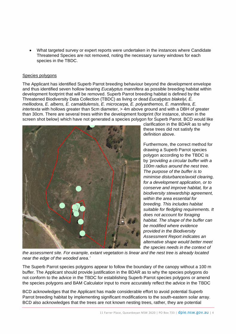
Species polygons
The Applicant has identified Superb Parrot breeding behaviour beyond the development envelope and thus identified seven hollow bearing Eucalyptus mannifera as possible breeding habitat within development footprint that will be removed. Superb Parrot breeding habitat is defined by the Threatened Biodiversity Data Collection (TBDC) as living or dead Eucalyptus blakelyi, E. melliodora, E. albens, E. camaldulensis, E. microcarpa, E. polyanthemos, E. mannifera, E. intertexta with hollows greater than 5cm diameter, > 4m above ground and with a DBH of greater than 30cm. There are several trees within the development footprint (for instance, shown in the screen shot below) which have not generated a species polygon for Superb Parrot. BCD would like
clarification in the BDAR as to why these trees did not satisfy the definition above. Furthermore, the correct method for
drawing a Superb Parrot species
polygon according to the TBDC is
by ‘providing a circular buffer with a
100m radius around the nest tree.
The purpose of the buffer is to
minimise disturbance/avoid clearing,
for a development application, or to
conserve and improve habitat, for a
biodiversity stewardship agreement,
within the area essential for
breeding. This includes habitat
suitable for fledgling requirements. It
does not account for foraging
habitat. The shape of the buffer can
be modified where evidence
provided in the Biodiversity
Assessment Report indicates an
alternative shape would better meet
the species needs in the context of
the assessment site. For example, extant vegetation is linear and the nest tree is already located
near the edge of the wooded area.’
The Superb Parrot species polygons appear to follow the boundary of the canopy without a 100 m
buffer. The Applicant should provide justification in the BDAR as to why the species polygons do
not conform to the advice in the TBDC for establishing Superb Parrot species polygons or amend
the species polygons and BAM Calculator input to more accurately reflect the advice in the TBDC
BCD acknowledges that the Applicant has made considerable effort to avoid potential Superb
Parrot breeding habitat by implementing significant modifications to the south-eastern solar array.
BCD also acknowledges that the trees are not known nesting trees, rather, they are potential
11 Farrer Place, Queanbeyan NSW 2620 | PO Box 733 | dpie.nsw.gov.au | 5
nesting trees based on known breeding records beyond the development footprint. Therefore, BCD
do not require the full 100 m buffer and instead recommend a smaller 20 m buffer from the drip
line of the canopy to create your species polygons. This will minimise impacts to tree health and
also alleviate risk of falling tree limbs on to solar panels once in place.
BCD has reviewed the GSM species polygons and BAM C input for the direct impacts and we are
satisfied that the credit obligation has been correctly calculated.
Prescribed impacts on GSM
It is not clear from the BDAR if the prescribed impact from removal of 188.36 ha of non-native
vegetation that potentially supports GSM was considered. Section 9.2.1.4 of the BAM requires that
non-native vegetation supporting threatened species - such as GSM - must undergo an
assessment of prescribed impacts which -
(a) identifies the areas of non-native vegetation which forms habitat for the species
(b) describes the nature, extent and duration of short and long-term impacts
(c) describes, with reference to relevant literature and other reliable published sources of
information, the importance within the bioregion of the habitat to these species,
(d) predicts the consequences of the impacts for the local and bioregional persistence of the
threatened species and communities likely to use these areas as habitat, with reference to
relevant literature and other published sources of information.
BCD recommends updating the BDAR in accordance with Section 9.2.1.4 of the BAM to include a
prescribed impacts assessment for the removal of non-native vegetation which might support
GSM. This would include a map showing GSM detections in non-native vegetation. The mitigation
measures for prescribed impacts should be in line with Sections 2.6 and 2.7 of the BAM Stage 2
Operational Manual. If mitigation measures or adaptive management are not applicable, the
Applicant should offset for prescribed impacts in accordance with Section 2.5.4 BAM Stage 2
Operational Manual.
Furthermore, the plot data for non-native vegetation needs to be entered into the BAMC for BCD to
be satisfied that:
(a) the VI score for areas of non-native vegetation is below the offsetting threshold, and
(b) Assist with the calculation of addition GSM credits if this is deemed suitable following the
SAII assessment.

11 Farrer Place, Queanbeyan NSW 2620 | PO Box 733 | dpie.nsw.gov.au | 6
Attachment 2 – BCD comments on the Response to Submissions Report for Springdale
Solar Farm and Aboriginal cultural heritage matters
The key issues raised in our previous correspondence that have not been adequately addressed in
the Response to Submissions Report (RTS) are:
Undertake subsurface archaeological test excavations prior to project approval
As previously advised we recommend that subsurface archaeological test excavation be undertaken across all areas that will be impacted by the solar farm, including ancillary infrastructure, prior to approval to inform the design of the solar farm. AECOM acknowledged poor visibility occurred during the archaeological survey and in response stated within the 2018 assessment report that a program of archaeological test excavation was necessary to “adequately characterise the Aboriginal archaeological record of the proposal site”. We support this recommendation as test excavations contribute to the understanding of the Aboriginal cultural heritage values of the area and they inform both avoidance and harm mitigation measures for the proposed activity. Given the time since the archaeological survey was undertaken - test excavations could have already been undertaken to identify constraints and help inform the footprint design. The proposed management and mitigation measures outlined in the RTS, such as leaving test excavations to post-approval, should not take the place of appropriate upfront assessment. We note that Ngunawal and Ngambri Elders raised concerns about the impacts of the Springdale Solar Farm on cultural values in the area after the 2018 assessment was completed. Undertaking the test excavations prior to approval may assist in addressing these concerns in understanding the nature and extent of all cultural values in the area before impact occurs. We recommend the proposed management measures in Table 8.0 include a commitment to undertaking consultation with the Aboriginal community about the cultural significance of the Springdale area.
A subsurface archaeological salvage program should be conducted after subsurface test
excavation has been completed
We note that the RTS makes several references to the archaeological salvage program. The mitigation measures proposed for Aboriginal cultural heritage outlined in Table 8.0 (page 143) needs to be updated to reflect that test excavations are a separate process to the proposed archaeological salvage program. Test excavation is part of an assessment process in order to determine the presence and significance of Aboriginal objects. The results of the test excavations, and a consideration of redesigning the footprint to avoid impacts, should determine whether surface and subsurface salvage is needed and how it should be carried out. Table 8.0 needs to include a commitment to considering the results of the testing before recommending salvage. It should not be assumed that salvage should automatically occur following test excavations.

v
3.5 Annexure E – Subdivision Plan
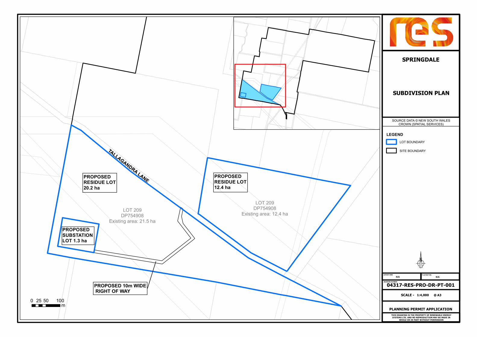
THIS DRAWING IS THE PROPERTY OF RENEWABLE ENERGYSYSTEMS LTD. AND NO REPRODUCTION MAY BE MADE IN
WHOLE OR IN PART WITHOUT PERMISSION
LAYOUT DWG T-LAYOUT NO.
DRAWING NUMBER
LOT 209DP754908
Existing area: 21.5 ha
LOT 209DP754908
Existing area: 12.4 ha
PROPOSED 10m WIDE RIGHT OF WAY
04317-RES-PRO-DR-PT-001N/AN/A
PLANNING PERMIT APPLICATION
1:4,000SCALE - @ A3
SPRINGDALE
SUBDIVISION PLAN
SOURCE DATA © NEW SOUTH WALESCROWN (SPATIAL SERVICES)
0 50 10025m
TALLAGANDRA LANE
TALLAGANDRA LANEPROPOSEDRESIDUE LOT20.2 ha
PROPOSEDRESIDUE LOT12.4 ha
LEGENDLOT BOUNDARY
SITE BOUNDARY
PROPOSEDSUBSTATIONLOT 1.3 ha