Embed Size (px)
Citation preview
61For free distribution
Spatial Patterns of Development in
Sri Lanka3
“Development is the improvement of the living standard of the global
community”. “Improvement of the economic, social, political and cultural sectors of a
country could be termed as development”. You have learnt similar ideas in grade 8 as
well. The purpose of this lesson is to examine physical and human processes which
have influenced the spatial patterns of development in selected regions of Sri Lanka.
Human activities adapted to physical factors are found in all regions in Sri
Lanka. Human needs satisfaction is planned to match the physical environment. Let
us study about this aspect by going through the lesson on spatial patterns of development
in Sri Lanka.
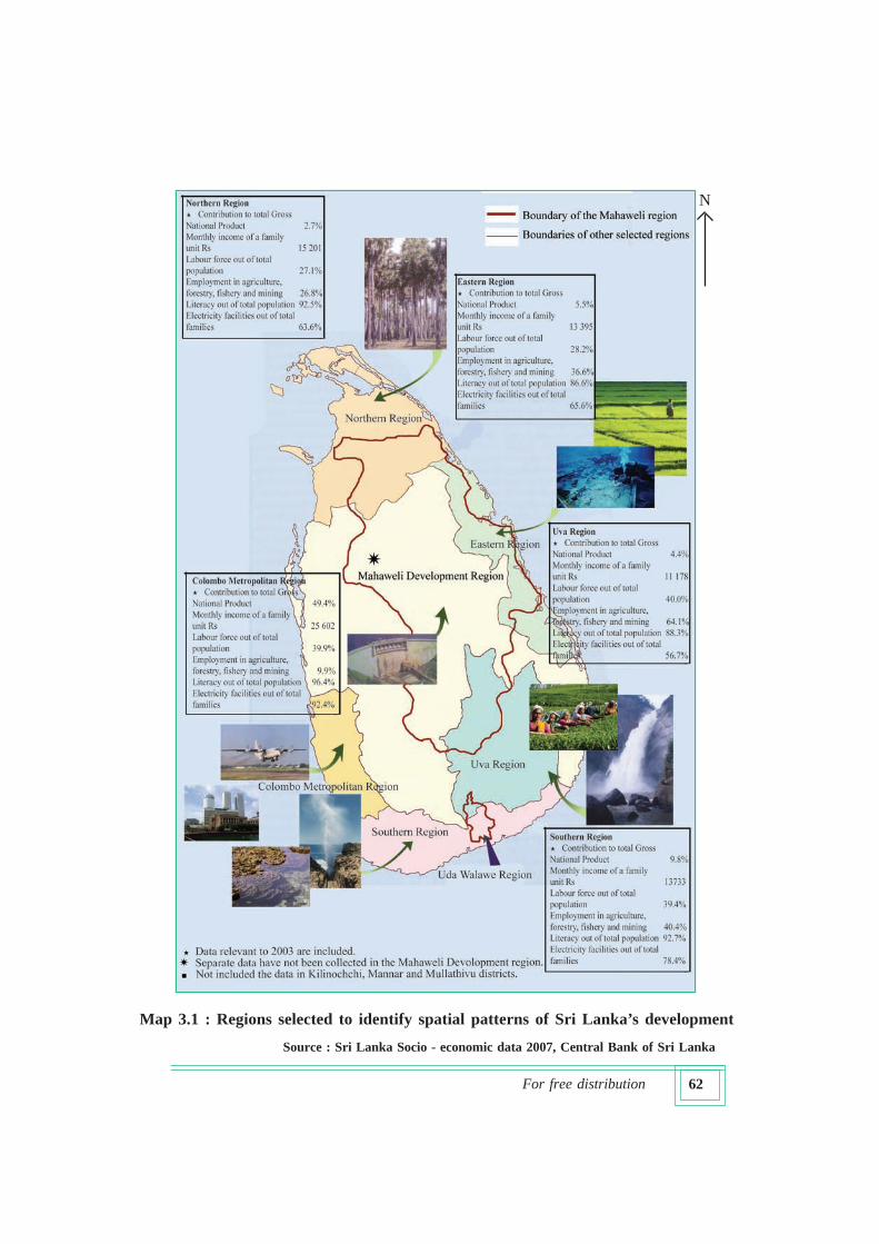
There are clear differences among the regions in Sri Lanka in terms of
development. Different socio-economic levels are observed in these regions.
Colombo Metropolitan Region comprising Colombo, Kalutara and Gampaha
Districts and Southern Region comprising Galle, Matara and Hambantota districts
have broadly similar development levels. Nevertheless, Uva Region comprising Badulla
and Monaragala districts and the Eastern Region comprising Batticaloa, Trincomalee
and Ampara districts have comparatively low levels of development. Gather more
information about these differences by studying Map 3.1.
Variations in the spatial patterns of development in the selected regions are
caused not only by the differences in the physical and human landscape but also by
disparities in resource distribution. An examination of the factors relating to the
physical and human landscape of the individual regions will give a better
understanding of the spatial patterns of development.
You have studied the criteria to differentiate a region when you were in lower
classes. Some of the criteria are given below :
1. Physical factors such as relief and climate
(central highlands, coastal plain, wet zone)
2. Human activities taking place within physical regions
(tea, rubber and paddy cultivation, terraced farming, chena cultivation)
3. Administrative boundaries, and boundaries defining service areas which
help in facilitating human activities.
(provinces, districts, city limits, communication networks, transport
networks, police areas, grama niladhari divisions,)
62For free distribution
Source : Sri Lanka Socio - economic data 2007, Central Bank of Sri Lanka
Map 3.1 : Regions selected to identify spatial patterns of Sri Lanka’s development
N
63For free distribution
Activities
1. With the aid of an atlas name three criteria used to demarcate Sri Lanka into
different Regions.
2. Name the Regions into which Sri Lanka is divided according to the above
criteria.
When you examine the inter-relationship between physical and human
processes in the selected regions you can clearly understand the following:
1. There are similarities among regions as well as physical factors which are
unique to particular regions (relief and climate found in the Uva Region are not
found in the Northern Region).
2. In examining levels of development among regions administrative units with
given boundaries have to be utilized for data collection (Provinces, Districts).
3. When we consider the development of the country, it is clear that the benefits
of development of a particular region spill over to other regions as welfare is
not restricted only to that region (entire country benefits from paddy and
electricity produced in the Mahaweli Region).
4. The spatial patterns of development within regions show that the benefits are
not equally distributed within the region (roads and pipe borne water facilities
found within the Colombo city limits are not available in distant townships,
rurban {between rural and urban} areas and rural areas in the Colombo
Metropolitan Region).
5. Certain regions of the country attract human resources in a way conducive to
development while in still other regions human resources tend to get pushed
out. (Western Region and Uva Region respectively).
6. Differences in the distribution of physical resources result in diverse human
activities.
Activities
1. “Mahaweli Development zone belongs to several regions” .Write two reasons
for this.
2. Write one reason specific to each region shown in Map 3.1.
64For free distribution
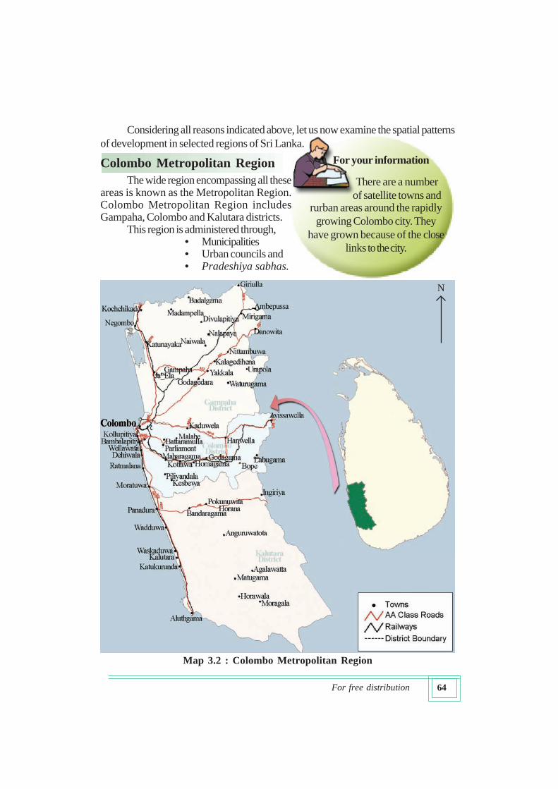
The wide region encompassing all theseareas is known as the Metropolitan Region.Colombo Metropolitan Region includesGampaha, Colombo and Kalutara districts.
This region is administered through,• Municipalities• Urban councils and• Pradeshiya sabhas.
For your information
There are a number
of satellite towns andrurban areas around the rapidly
growing Colombo city. They
have grown because of the close
links to the city.
Considering all reasons indicated above, let us now examine the spatial patterns
of development in selected regions of Sri Lanka.
Colombo Metropolitan Region
N
Map 3.2 : Colombo Metropolitan Region
65For free distribution
Activities
1. Name the districts in the Colombo Metropolitan Region.
2. Study Map 3.2 and prepare a list of satellite towns around the capital city of
Colombo.
3. Name the two rivers bordering North and South of this region.
4. On the basis of what you have heard, prepare a report on the Colombo
Metropolitan Region.
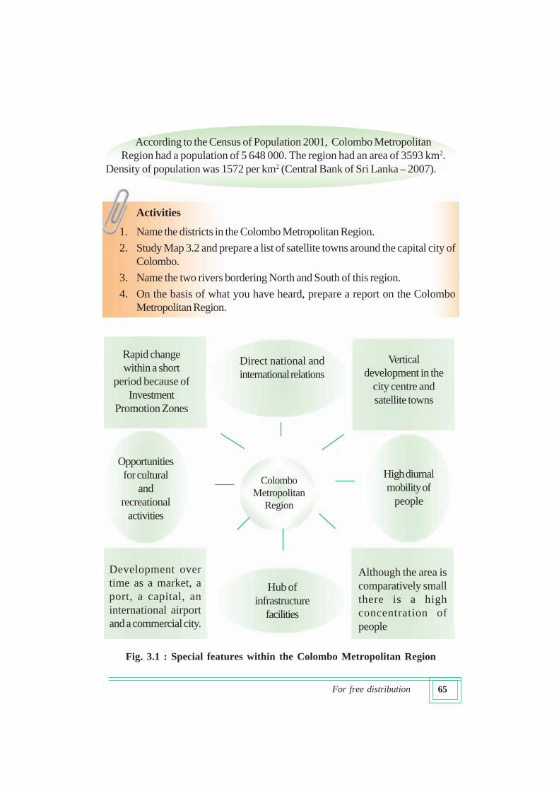
According to the Census of Population 2001, Colombo Metropolitan
Region had a population of 5 648 000. The region had an area of 3593 km2.
Density of population was 1572 per km2 (Central Bank of Sri Lanka – 2007).
Direct national and
international relations
Colombo
Metropolitan
Region
Vertical
development in the
city centre and
satellite towns
Hub of
infrastructure
facilities
Opportunities
for cultural
and
recreational
activities
Rapid change
within a short
period because of
Investment
Promotion Zones
High diurnal
mobility of
people
Although the area is
comparatively small
there is a high
concentration of
people
Development over
time as a market, a
port, a capital, an
international airport
and a commercial city.
Fig. 3.1 : Special features within the Colombo Metropolitan Region
66For free distribution
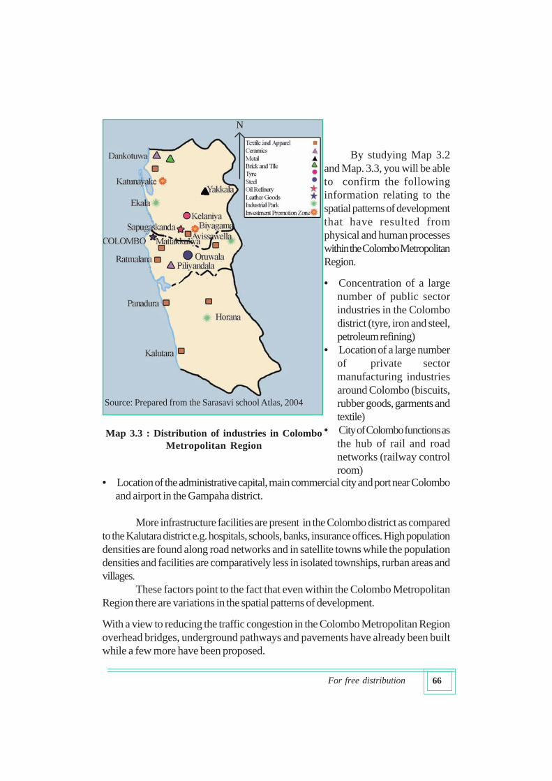
By studying Map 3.2
and Map. 3.3, you will be able
to confirm the following
information relating to the
spatial patterns of development
that have resulted from
physical and human processes
within the Colombo Metropolitan
Region.
• Concentration of a large
number of public sector
industries in the Colombo
district (tyre, iron and steel,
petroleum refining)
• Location of a large number
of private sector
manufacturing industries
around Colombo (biscuits,
rubber goods, garments and
textile)
• City of Colombo functions as
the hub of rail and road
networks (railway control
room)• Location of the administrative capital, main commercial city and port near Colombo
and airport in the Gampaha district.
More infrastructure facilities are present in the Colombo district as compared
to the Kalutara district e.g. hospitals, schools, banks, insurance offices. High population
densities are found along road networks and in satellite towns while the population
densities and facilities are comparatively less in isolated townships, rurban areas and
villages.
These factors point to the fact that even within the Colombo Metropolitan
Region there are variations in the spatial patterns of development.
With a view to reducing the traffic congestion in the Colombo Metropolitan Region
overhead bridges, underground pathways and pavements have already been built
while a few more have been proposed.
Map 3.3 : Distribution of industries in Colombo
Metropolitan Region
Source: Prepared from the Sarasavi school Atlas, 2004
N
67For free distribution
Activity
Prepare a folder on the Colombo Metropolitan Region on the basis of the
information you have studied.
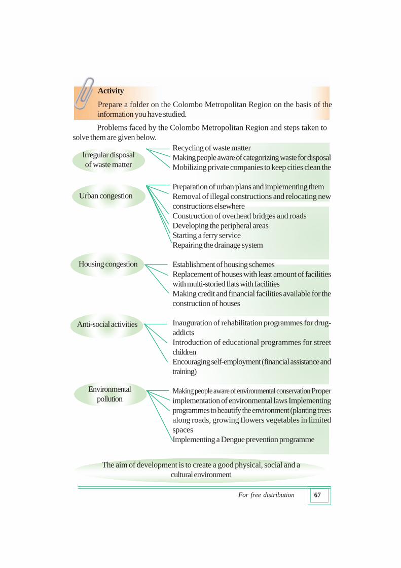
Problems faced by the Colombo Metropolitan Region and steps taken to
solve them are given below.
Recycling of waste matter
Making people aware of categorizing waste for disposal
Mobilizing private companies to keep cities clean the
Preparation of urban plans and implementing them
Removal of illegal constructions and relocating new
constructions elsewhere
Construction of overhead bridges and roads
Developing the peripheral areas
Starting a ferry service
Repairing the drainage system
Establishment of housing schemes
Replacement of houses with least amount of facilities
with multi-storied flats with facilities
Making credit and financial facilities available for the
construction of houses
Inauguration of rehabilitation programmes for drug-
addicts
Introduction of educational programmes for street
children
Encouraging self-employment (financial assistance and
training)
Making people aware of environmental conservation Proper
implementation of environmental laws Implementing
programmes to beautify the environment (planting trees
along roads, growing flowers vegetables in limited
spaces
Implementing a Dengue prevention programme
Irregular disposal
of waste matter
Urban congestion
Anti-social activities
Environmental
pollution
Housing congestion
The aim of development is to create a good physical, social and a
cultural environment
68For free distribution
Mahaweli Development Region
Mahaweli river which is 331 km. long starts from the Horton Plains and meets
the sea close to Trincomalee. It is estimated that the area watered by the Mahaweli in
this long journey is about 10,327 km2 .
Government of Sri Lanka which realized the importance of tapping the volume
of water discharged by the river started the first phase of the Mahaweli Scheme at
Polgolla and Bowatenna in February 1970. Mahaweli Development Programme that
was scheduled for completion in 30 years was redesigned to be completed in 6 years
and the construction work on Kotmale, Victoria, Randenigala, Maduru Oya reservoirs
and the right trans-basin canal commenced simultaneously.
The Uda Walawe Scheme and Weli Oya region (renamed as System L)
administered by the River Valley Development Board were also brought under the
purview of the Mahaweli Authority in 1982 and 1987 respectively.
Meeting the set target, 162,932 families were settled by 2010. Out of this
96,835 were farm families while the others belonged to the categories of businessmen
and those engaged in other pursuits. Hydro power generated by the Mahaweli amounted
to 671 Mega Watts. During this year Mahaweli farmers obtained water for 150,598
ha.and produced 707,836 metric tonnes of paddy. This is equivalent to 21% of the
total paddy production of the country (Mahaweli Authority of Sri Lanka 2005,2010).
Moragahakanda Project proposed for the second stage of the Mahaweli
Scheme was inaugurated on 25th of January 2007 to meet the needs of the country. It
is nearing completion now.
In view of the above the largest multi-purpose development scheme in the
country is the Mahaweli Development Scheme.
Activities
1. If you are elected as a president of a social organization in the Colombo
Metropoletan Region, prepare a speech that you would make about the
steps that you would take to develop the region.
2. List the reasons why human resources are attracted to this region from
elsewhere.
69For free distribution
For your information
Mahaweli Development Region is not limited to the region
watered by the river Mahaweli alone. This project encompasses a number of river
valleys while contributing to feed others beyond its own catchment. It has also
conferred direct benefits to a number of Districts and Provinces.
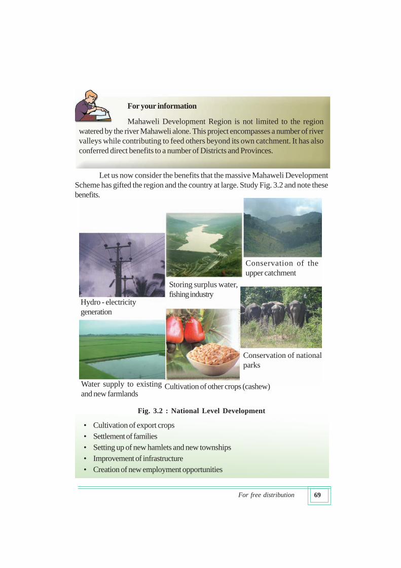
Let us now consider the benefits that the massive Mahaweli Development
Scheme has gifted the region and the country at large. Study Fig. 3.2 and note these
benefits.
• Cultivation of export crops
• Settlement of families
• Setting up of new hamlets and new townships
• Improvement of infrastructure
• Creation of new employment opportunities
Hydro - electricity
generation
Storing surplus water,
fishing industry
Conservation of the
upper catchment
Water supply to existing
and new farmlandsCultivation of other crops (cashew)
Conservation of national
parks
Fig. 3.2 : National Level Development
70For free distribution
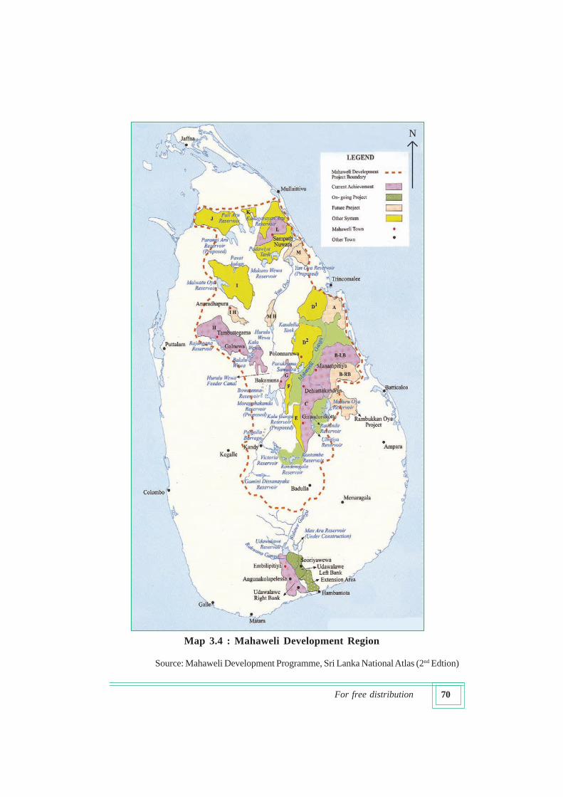
Source: Mahaweli Development Programme, Sri Lanka National Atlas (2nd Edtion)
Map 3.4 : Mahaweli Development Region
N
71For free distribution
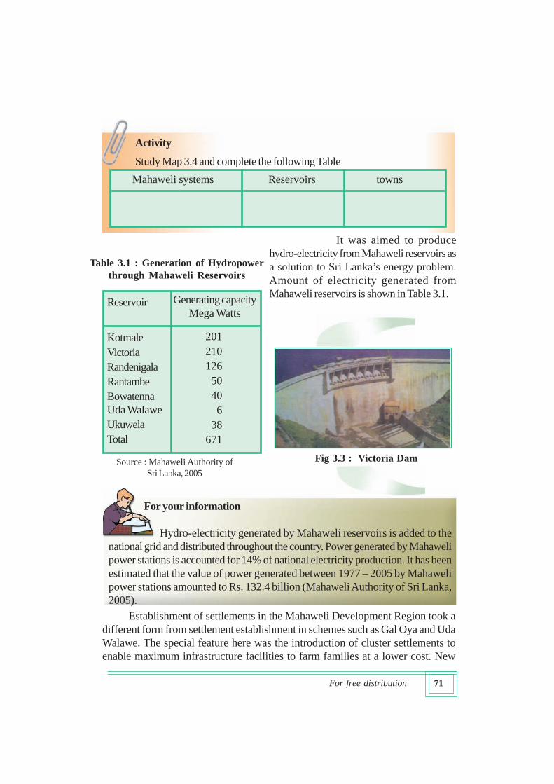
Table 3.1 : Generation of Hydropower
through Mahaweli Reservoirs
For your information
Hydro-electricity generated by Mahaweli reservoirs is added to the
national grid and distributed throughout the country. Power generated by Mahaweli
power stations is accounted for 14% of national electricity production. It has been
estimated that the value of power generated between 1977 – 2005 by Mahaweli
power stations amounted to Rs. 132.4 billion (Mahaweli Authority of Sri Lanka,
2005).
Activity
Study Map 3.4 and complete the following Table
Mahaweli systems Reservoirs towns
Fig 3.3 : Victoria Dam
Generating capacity
Mega Watts
201
210
126
50
40
6
38
671
Reservoir
Kotmale
Victoria
Randenigala
Rantambe
Bowatenna
Uda Walawe
Ukuwela
Total
Source : Mahaweli Authority of
Sri Lanka, 2005
It was aimed to produce
hydro-electricity from Mahaweli reservoirs as
a solution to Sri Lanka’s energy problem.
Amount of electricity generated from
Mahaweli reservoirs is shown in Table 3.1.
Establishment of settlements in the Mahaweli Development Region took a
different form from settlement establishment in schemes such as Gal Oya and Uda
Walawe. The special feature here was the introduction of cluster settlements to
enable maximum infrastructure facilities to farm families at a lower cost. New
72For free distribution
settlements, new hamlets, new towns, new markets and new roads have been
established under Mahaweli settlements.
Following family units have received priority in the settlement process of the
Mahaweli region.
• Those displaced because their lands were inundated by the reservoirs
• Original settlers of the Mahaweli region
• Families selected from different parts of the country
• Non-farm families attracted to the region (to engage in manufacturing industries
and business activities)
• Farm families who grow additional crops (cashew cultivation)
Activities
1. With the help of an atlas examine the course of the river Mahaweli and name
the Districts and Provinces through which the river flows.
2. Mark and name three new townships of the Mahaweli Region in a map showing
the Mahaweli Region.
3. Make a list of old tanks presently fed by Mahaweli waters.
4. Prepare an article titled “New Vistas of Mahaweli” and present it to the class.
Among the aims of developing the Mahaweli Region were to face the then
prevailing food crisis of the country and reduce the escalating prices of rice in the
world market. Farm families who were settled in the region contributed to the production
of rice and other field crops. Downstream areas of Mahaweli and Uda Walawe
contributed towards 20 -25% of national paddy production in the year 2000
(Abhayaratna, 2005).
When the following factors are considered, the Mahaweli Development
Region is of special significance as compared to other regions of Sri Lanka.
• Covers a number of Districts and Provinces
• Development aims at achieving multi-purpose development targets
• Contributes to resolve power, food and unemployment problems.
Regional variations could be seen even within the Mahaweli Development
Region. For example, in downstream areas variations in agricultural patterns as well
as secondary economic activities exist between the originally established System H
and subsequently developed C and B Systems. Similar differences are observed in
regard to road densities and growth of service centres. Downstream areas of the
Mahaweli region have been more important than the upstream areas for settlement
development. Most parts of the upstream areas are demarcated as conservation areas.
73For free distribution
After work
Prepare a model of a reservoir with the help of your teacher and present it to the
year-end exhibition of the school.
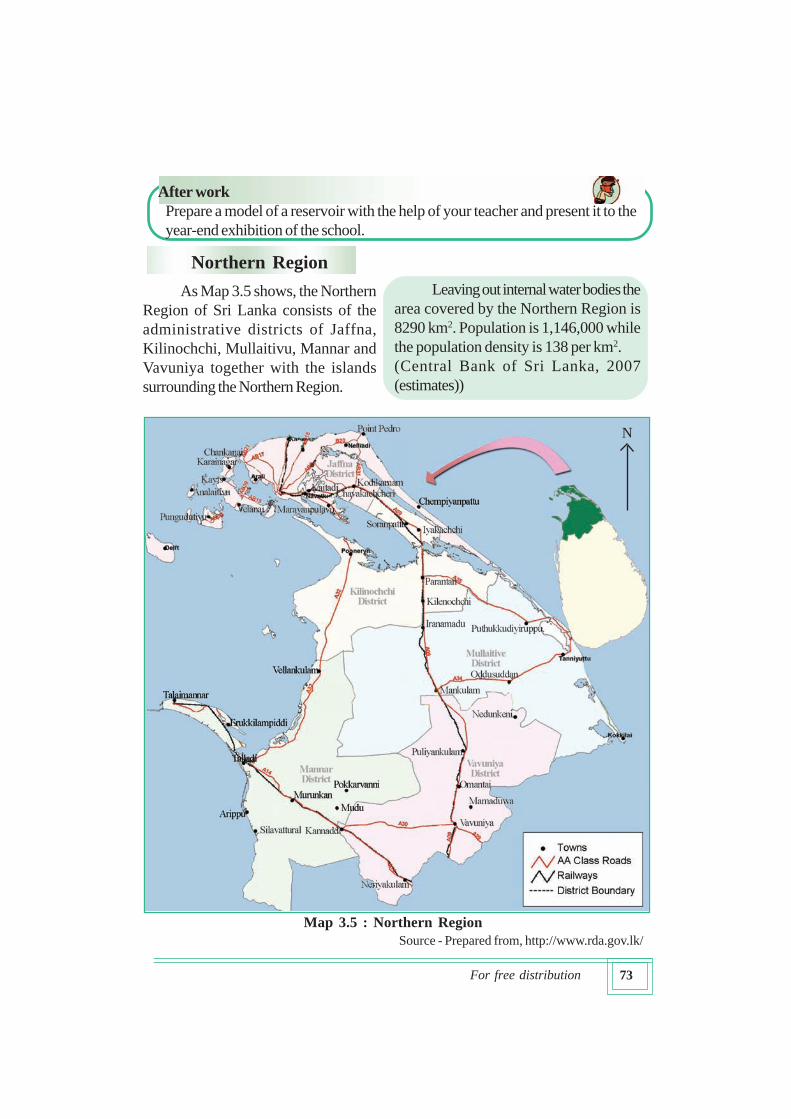
Northern Region
As Map 3.5 shows, the Northern
Region of Sri Lanka consists of the
administrative districts of Jaffna,
Kilinochchi, Mullaitivu, Mannar and
Vavuniya together with the islands
surrounding the Northern Region.
Leaving out internal water bodies the
area covered by the Northern Region is
8290 km2. Population is 1,146,000 while
the population density is 138 per km2.
(Central Bank of Sri Lanka, 2007
(estimates))
Source - Prepared from, http://www.rda.gov.lk/
N
Map 3.5 : Northern Region
74For free distribution
The teacher organized groups of students to collect data on the spatial patterns
of development in the Northern Region and provided them with books and journals
for the purpose. The reports that were presented by the students on the basis of such
material are given below. Report presented by Thilina on the physical features of the
Northern Region is given below.
Let us recognize the physical environment of the Northern Region.
Characteristic features of the Northern
Region
• Annual rainfall is between 1000-1500
mm.
• Most of the rainfall is received during
the months of the Northeast monsoon.
• Average annual temperature is about
250C - 27.50C
• There is a long dry season
• A large proportion of the region
belongs to the dry zone and a small
section near Mannar to the semi-arid
zone.
• There is no surface drainage. Even the small streams present, dry off during
the dry season.
• Mineral sands and Miocene limestones are found in abundance.
• Soil fertility is low in most of the areas of the peninsula. However, locations
around Chunnakam and Chavakachcheri and areas with fertile red calcareous
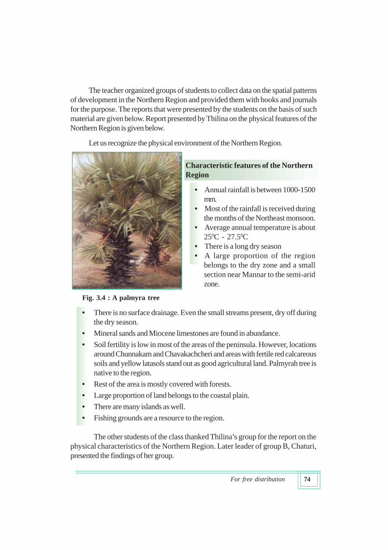
soils and yellow latasols stand out as good agricultural land. Palmyrah tree is
native to the region.
• Rest of the area is mostly covered with forests.
• Large proportion of land belongs to the coastal plain.
• There are many islands as well.
• Fishing grounds are a resource to the region.
The other students of the class thanked Thilina’s group for the report on the
physical characteristics of the Northern Region. Later leader of group B, Chaturi,
presented the findings of her group.
Fig. 3.4 : A palmyra tree
75For free distribution
What they presented is given below.
You may have received an understanding of the physical environment and
human activities of the Northern Region from these group presentations. Now try to
grasp the inter-relationship between the physical and the human environment of the
Northern Region from Dumindu’s report.
Major economic
activities are
agriculture and fishing
Productions are done
using minerals such as
limestone, mineral
sands and clay
Fishing
and
related
activities
provide
employment
Dry crops, home
garden cultivation/
market gardening
are important
Important for
Palmyrah related
products
Dry grains, red
onions, chillies,
tobacco and bananas
are grown
Traditional well
irrigation is being
replaced by modern
irrigation methods
Human
activities in
the
Northern
Region
Agriculture
is done by
irrigration
and rainfed
waters.
Fig. 3.5 : Nature of human activities in the Northern Region
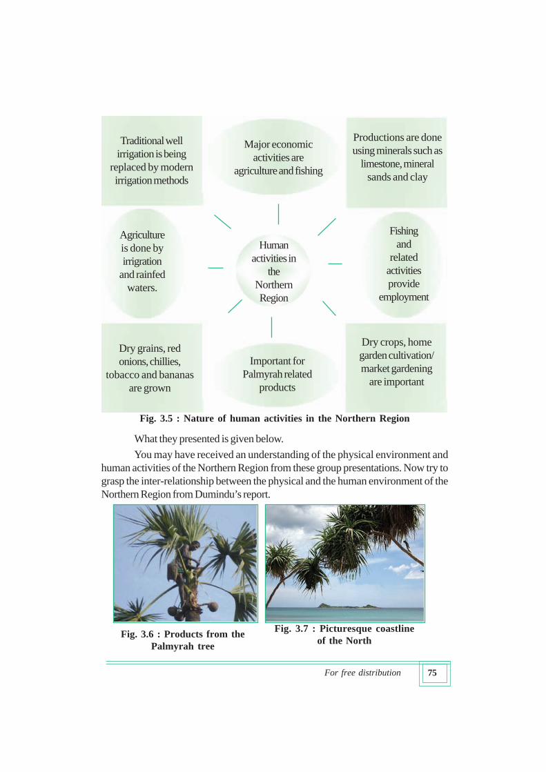
Fig. 3.6 : Products from the
Palmyrah tree
Fig. 3.7 : Picturesque coastline
of the North
76For free distribution
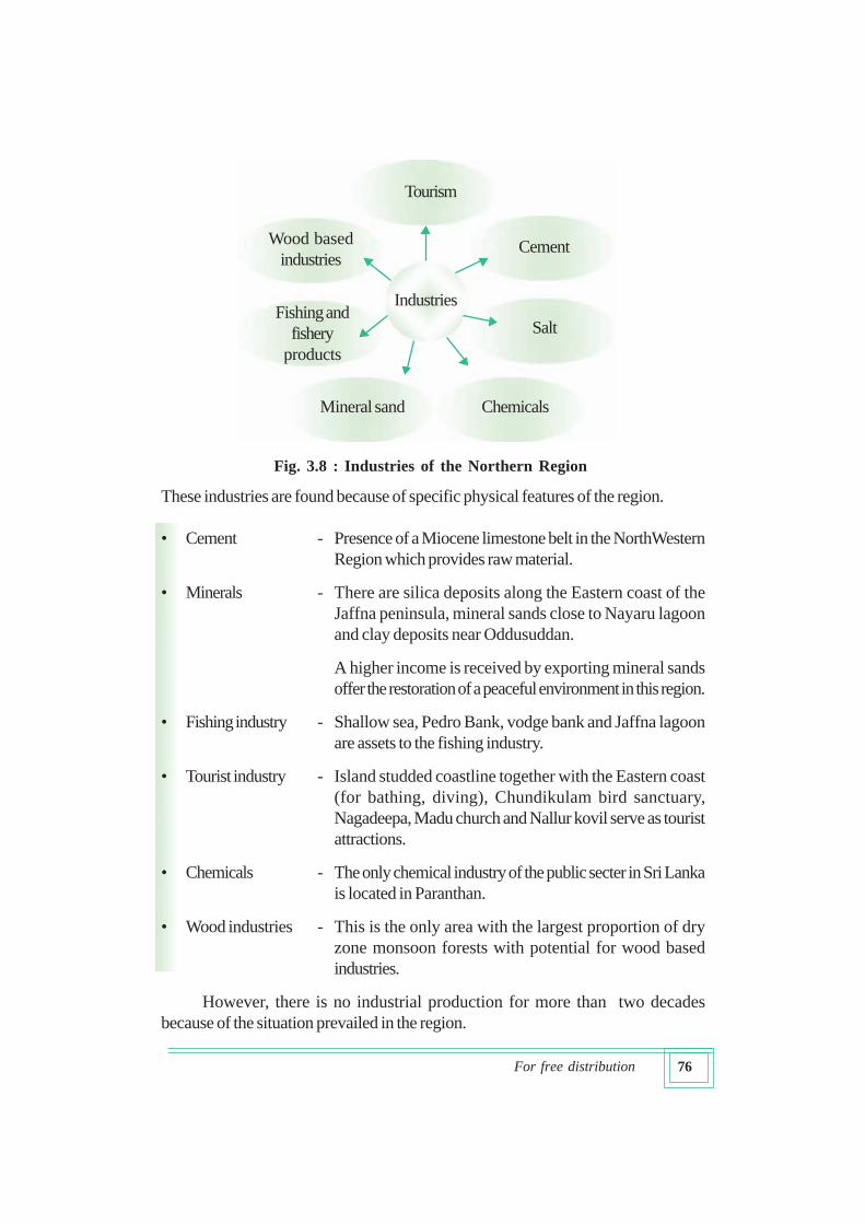
These industries are found because of specific physical features of the region.
• Cement - Presence of a Miocene limestone belt in the NorthWestern
Region which provides raw material.
• Minerals - There are silica deposits along the Eastern coast of the
Jaffna peninsula, mineral sands close to Nayaru lagoon
and clay deposits near Oddusuddan.
A higher income is received by exporting mineral sands
offer the restoration of a peaceful environment in this region.
• Fishing industry - Shallow sea, Pedro Bank, vodge bank and Jaffna lagoon
are assets to the fishing industry.
• Tourist industry - Island studded coastline together with the Eastern coast
(for bathing, diving), Chundikulam bird sanctuary,
Nagadeepa, Madu church and Nallur kovil serve as tourist
attractions.
• Chemicals - The only chemical industry of the public secter in Sri Lanka
is located in Paranthan.
• Wood industries - This is the only area with the largest proportion of dry
zone monsoon forests with potential for wood based
industries.
However, there is no industrial production for more than two decades
because of the situation prevailed in the region.
Fishing and
fishery
products
Industries
Salt
Tourism
ChemicalsMineral sand
Wood based
industriesCement
Fig. 3.8 : Industries of the Northern Region
77For free distribution
The teacher who thanked the students for their presentations provided them
with more details about the Northern Region.
Infrastructure facilities
• Harbour - Kankesanturai
• Airports - Palali, Vavuniya
• Major roads - Road network linked to Jaffna – Kandy A 9 road
• Railway stations - Northern line is repaired upto Omanthei
(work in Re-establishing railway link to Jaffna is in
progress)
• Higher education - Jaffna University, Vavuniya University
• Communication facilities - Highest Multipurpose commuication tower in Sri Lanka
has been constructed in Kokawil of Mullaitivu District.
In addition to these facilities, the residents of Jaffna use electronic
communication networks to access radio and television programmes broadcast from
neighbouring India. Fishing industry is fairly well developed (see Table 3.2).
Source : Survey Department of Sri Lanka, 1997
Sri Lanka National Atlas (School Edition)
It is possible to recognize problems and constraints when we study the spatial
patterns of development in different regions of the country. This applies in equal measure
to the Northern Region as well.
District Fish landing centres Ice producing centres
Mullaitivu 45 3
Jaffna 83 12
Mannar 24 3
Table 3.2 : Facilities provided for the fishing industry in the
Northern Region
78For free distribution
In the past farmers who practised traditional lift irrigation and rainfed cultivation
produced small surpluses for the market in addition to meeting their requirements. At present
they use modern irrigation methods and pay more attention to the cultivation of commercial
crops such as chillies, red onions, vegetables, grapes and fruits. Suppling fertilizers for a
concessionary price to farmers has also resulted in increasing the agro- products.
Although there are a few industries such as cement, chemicals and mineral
sands which have distinct locational advantages in the Northern Region there has
been no production for nearly two decades.
The war situation and the tsunami disaster which occurred in December 2004
were instrumental in creating many problems in the region. Presently different projects
are implemented for the development of the Northern Region. Among them are,
• Rehabilitation of the transport network
• Re-construction of railways including Vavuniya – Kankesanturai line
• Development of industries
• Improvement of infrastructure facilities
• Provision of facilities for the displaced people. Under the North – East Housing
Rehabilitation Project (NEHRP) 31.69% of the target for 2004 -2009 had
been achieved by the end of December 2007 (Nation Building and
Infrastructure Development Ministry, 2008).
Accordingly, it is seen that both the government and national and international
non-governmental organizations have paid attention to the development of the Northern
Region. “Uturu Wasanthaya” (Northern Spring) development programme was
launched under the present government in 2008 in order to rehabilitate the region.
79For free distribution
Activities
1. Mark and name the distribution of mineral resources in the Northern Region.
2. Make a list of places of tourist attraction in the Northern Region.
3. Identify a few differences between the Jaffna peninsula and the mainland
areas of the Northern Region.
4. Prepare a folder using media information on the “Uturu Wasanthaya”
programme implemented by the government of Sri Lanka for the development
of the Northern Region.
Uva Region
The Uva Region had attained a high level of agricultural development in the
days of the Kandyan kingdom. This region had also been called “Wellassa” due to
the presence of paddy fields numbering about one hundred thousand. Mountain
ranges, passes, waterfalls plateaus and escarpments provided natural protection to
this region while the physical environment stood as a barrier to maintain relationships
with other regions.
This region consists of Badulla and Monaragala districts.
Apart from internal water bodies the area covered by the Uva Region is 8335 km2.
Population is 1,257,000 while the population density is 151 per km2.
(Central Bank of Sri Lanka, 2007)
In order to obtain information pertaining to the region the class teacher
introduced Mr. Sirimal who was born in the Badulla Lunugala area and joined the
staff after completing higher education. The discussion that Mr. Sirimal conducted
with the help of maps and a CD was summarized on the blackboard as follows:
80For free distribution
Let us recognize the physical environment of the Uva Region
• A large proportion of the region is between 30 – 300 m in elevation.
Namunukula peak 2036 m high is found in this region.
• Rainfall is received from the North East monsoon and the major paddy
cultivation is also done in the same season
• Climatically the region belongs to dry montane and low country dry zone
types.
• Many small and large rivers start from Welimada plateau and Namunukula
range and flow in different directions.
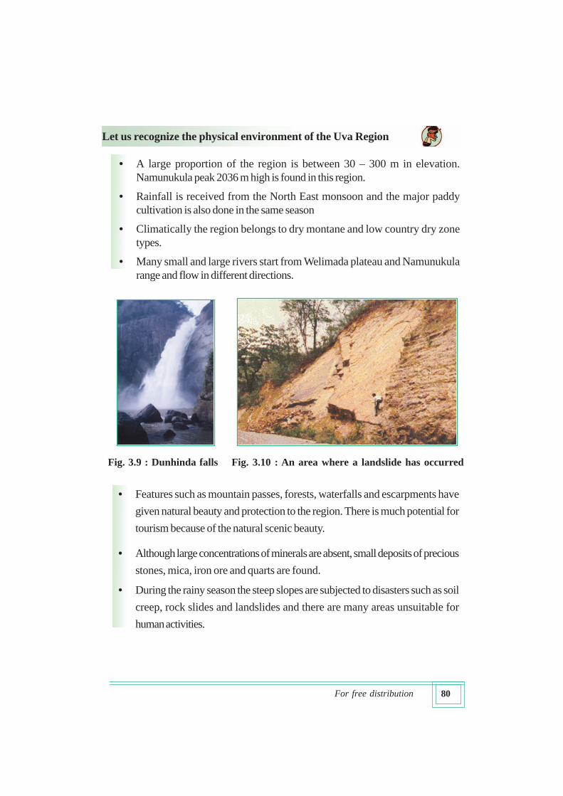
• Features such as mountain passes, forests, waterfalls and escarpments have
given natural beauty and protection to the region. There is much potential for
tourism because of the natural scenic beauty.
• Although large concentrations of minerals are absent, small deposits of precious
stones, mica, iron ore and quarts are found.
• During the rainy season the steep slopes are subjected to disasters such as soil
creep, rock slides and landslides and there are many areas unsuitable for
human activities.
Fig. 3.9 : Dunhinda falls Fig. 3.10 : An area where a landslide has occurred
81For free distribution
• Unfavourable climate due to the occurrence of annual droughts in the
Monaragala Region has been instrumental in pushing the human resource out
of the area rather than attracting it.
• The physical environment has influenced population distribution of the region
as well as human activities.
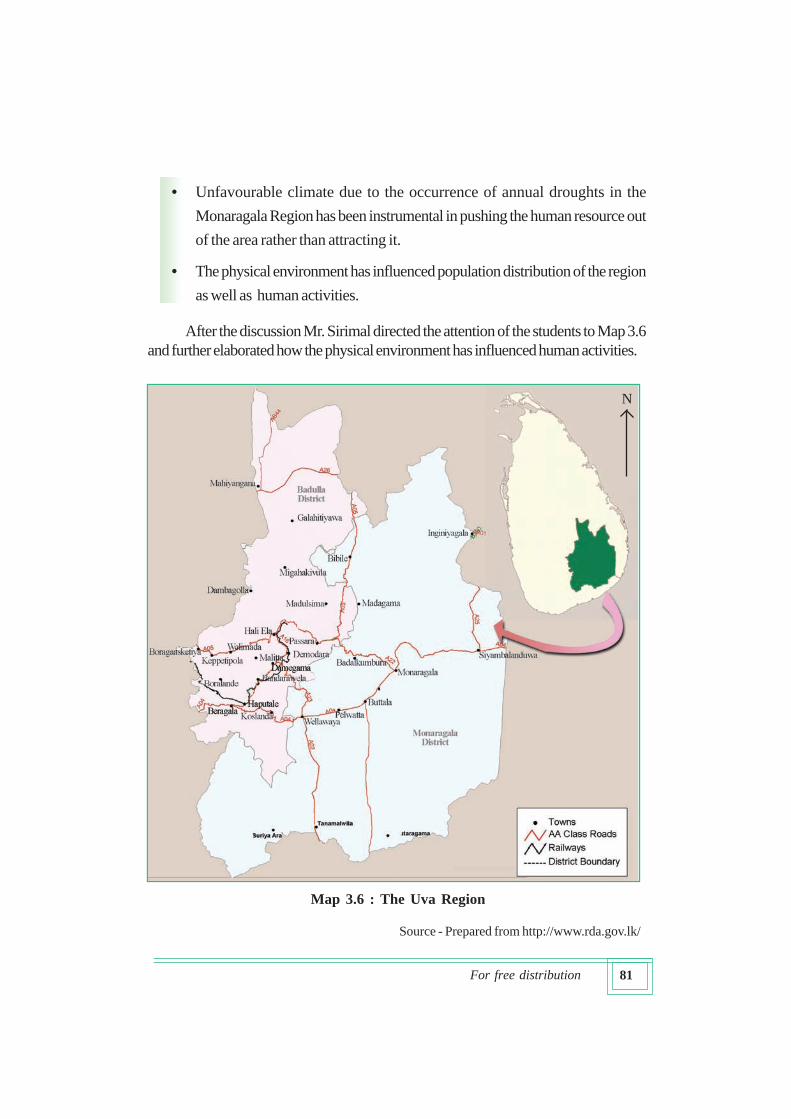
After the discussion Mr. Sirimal directed the attention of the students to Map 3.6
and further elaborated how the physical environment has influenced human activities.
Source - Prepared from http://www.rda.gov.lk/
N
Map 3.6 : The Uva Region
82For free distribution
Influence of the physical environment on human activities and the
development of the region
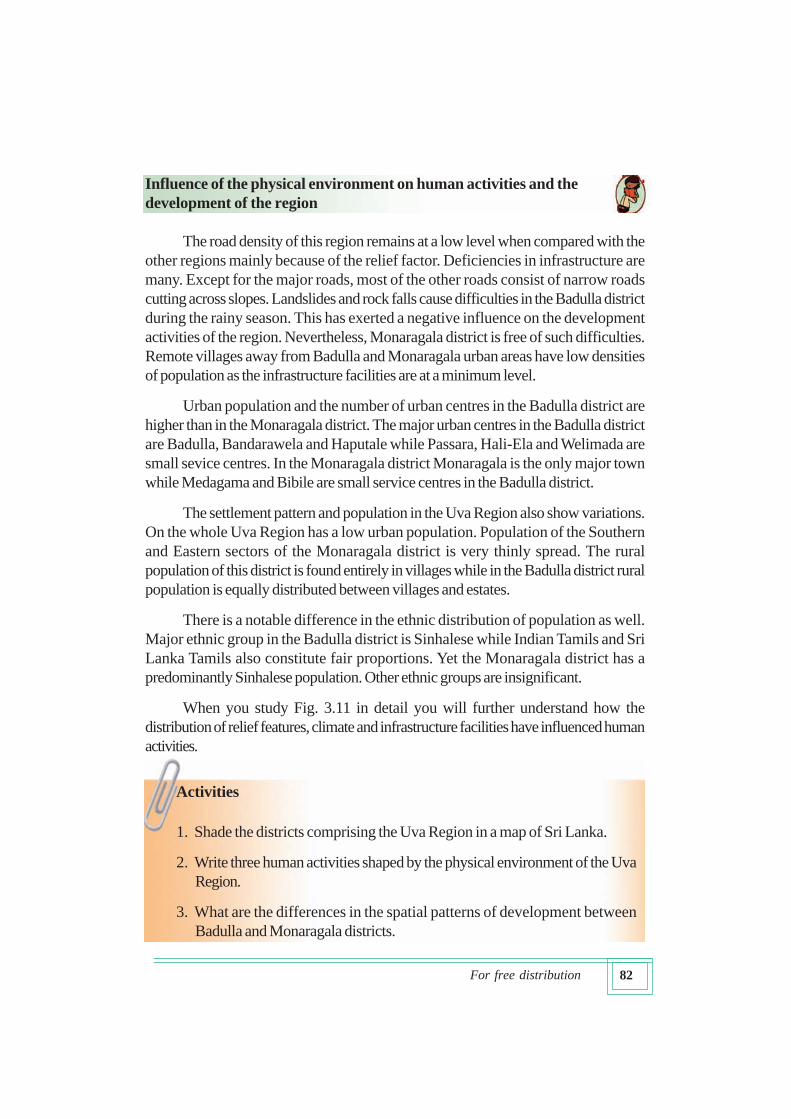
The road density of this region remains at a low level when compared with the
other regions mainly because of the relief factor. Deficiencies in infrastructure are
many. Except for the major roads, most of the other roads consist of narrow roads
cutting across slopes. Landslides and rock falls cause difficulties in the Badulla district
during the rainy season. This has exerted a negative influence on the development
activities of the region. Nevertheless, Monaragala district is free of such difficulties.
Remote villages away from Badulla and Monaragala urban areas have low densities
of population as the infrastructure facilities are at a minimum level.
Urban population and the number of urban centres in the Badulla district are
higher than in the Monaragala district. The major urban centres in the Badulla district
are Badulla, Bandarawela and Haputale while Passara, Hali-Ela and Welimada are
small sevice centres. In the Monaragala district Monaragala is the only major town
while Medagama and Bibile are small service centres in the Badulla district.
The settlement pattern and population in the Uva Region also show variations.
On the whole Uva Region has a low urban population. Population of the Southern
and Eastern sectors of the Monaragala district is very thinly spread. The rural
population of this district is found entirely in villages while in the Badulla district rural
population is equally distributed between villages and estates.
There is a notable difference in the ethnic distribution of population as well.
Major ethnic group in the Badulla district is Sinhalese while Indian Tamils and Sri
Lanka Tamils also constitute fair proportions. Yet the Monaragala district has a
predominantly Sinhalese population. Other ethnic groups are insignificant.
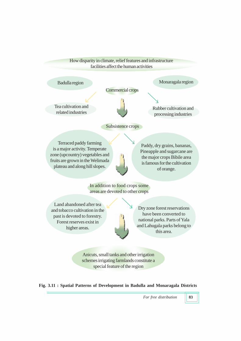
When you study Fig. 3.11 in detail you will further understand how the
distribution of relief features, climate and infrastructure facilities have influenced human
activities.
Activities
1. Shade the districts comprising the Uva Region in a map of Sri Lanka.
2. Write three human activities shaped by the physical environment of the Uva
Region.
3. What are the differences in the spatial patterns of development between
Badulla and Monaragala districts.
83For free distribution
How disparity in climate, relief features and infrastructure
facilities affect the human activities
Badulla region Monaragala region
Tea cultivation and
related industriesRubber cultivation and
processing industries
Dry zone forest reservations
have been converted to
national parks. Parts of Yala
and Lahugala parks belong to
this area.
Commercial crops
Subsistence crops
In addition to food crops some
areas are devoted to other crops
Anicuts, small tanks and other irrigation
schemes irrigating farmlands constitute a
special feature of the region
Terraced paddy farming
is a major activity. Temperate
zone (upcountry) vegetables and
fruits are grown in the Welimada
plateau and along hill slopes.
Paddy, dry grains, bananas,
Pineapple and sugarcane are
the major crops Bibile area
is famous for the cultivation
of orange.
Land abandoned after tea
and tobacco cultivation in the
past is devoted to forestry.
Forest reserves exist in
higher areas.
Fig. 3.11 : Spatial Patterns of Development in Badulla and Monaragala Districts
84For free distribution
It is important to pay due attention to irrigation methods which support
agriculture. Among the irrigation methods found there are large irrigation schemes,
large anicuts, small tanks and small anicuts (large irrigation schemes are those which
irrigate more than 80 ha.). There are differences in the use of these methods within the
Uva Region. Small anicut schemes constructed by blocking small streams constitute
the predominant method of irrigation in the Badulla district. These are widely used to
irrigate vegetable cultivation. In the Monaragala district, major schemes such as Etimale,
Yudaganawa, Handapanagala, Mahawewa and Hambegamuwa are more important.
Varied development programmes have been implemented during the last two
decades to solve the problems faced by the Uva Region. Village-centered projects
that satisfy community needs have yielded good results.
Some projects intended to improve the living conditions of the people in the
region are summarized below under the headings of agriculture, industries, infrastructure
and environmental conservation.
Agriculture
• Streams are blocked by anicuts and water is taken along the contour drains
to irrigate farmlands. (Pradeshiya Sabhas rehabilitate these irrigation
networks on an annual basis).
• Protection of small holders of tea through tea small holder development
societies.
• Improvement of orange cultivation in the Bibile region.
• Implementing people’s livelihood development through farmer organizations.
• Inauguration of Padiyatalawa and Monaragala cashew processing
demonstration and purchasing centres and planning for the establishment of
seed farms.
• Improvement of marketing facilities for the products of low income receivers.
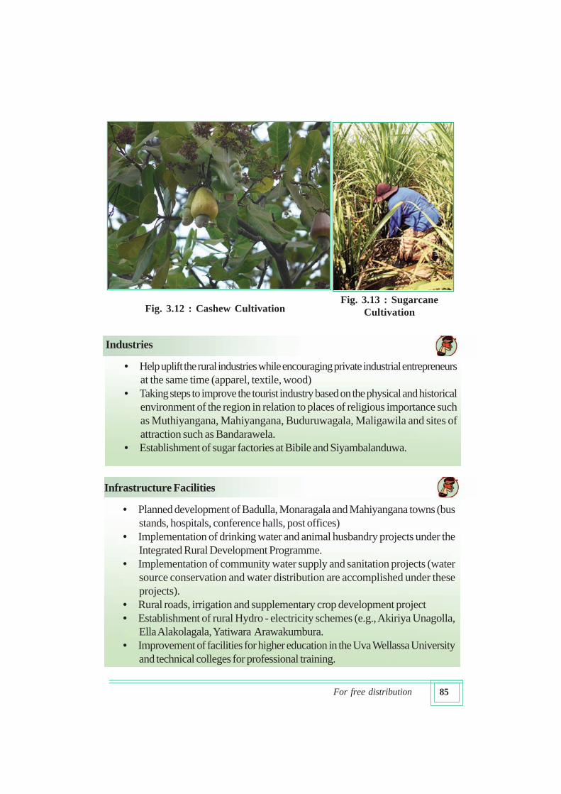
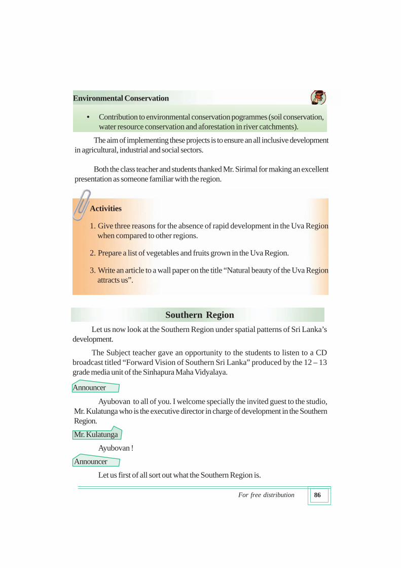
• Establishment of a sugarcane cultivation project to produce sugar.
85For free distribution
Industries
• Help uplift the rural industries while encouraging private industrial entrepreneurs
at the same time (apparel, textile, wood)
• Taking steps to improve the tourist industry based on the physical and historical
environment of the region in relation to places of religious importance such
as Muthiyangana, Mahiyangana, Buduruwagala, Maligawila and sites of
attraction such as Bandarawela.
• Establishment of sugar factories at Bibile and Siyambalanduwa.
Infrastructure Facilities
• Planned development of Badulla, Monaragala and Mahiyangana towns (bus
stands, hospitals, conference halls, post offices)
• Implementation of drinking water and animal husbandry projects under the
Integrated Rural Development Programme.
• Implementation of community water supply and sanitation projects (water
source conservation and water distribution are accomplished under these
projects).
• Rural roads, irrigation and supplementary crop development project
• Establishment of rural Hydro - electricity schemes (e.g., Akiriya Unagolla,
Ella Alakolagala, Yatiwara Arawakumbura.
• Improvement of facilities for higher education in the Uva Wellassa University
and technical colleges for professional training.
Fig. 3.13 : Sugarcane
CultivationFig. 3.12 : Cashew Cultivation
86For free distribution
Environmental Conservation
Activities
1. Give three reasons for the absence of rapid development in the Uva Region
when compared to other regions.
2. Prepare a list of vegetables and fruits grown in the Uva Region.
3. Write an article to a wall paper on the title “Natural beauty of the Uva Region
attracts us”.
Southern Region
Let us now look at the Southern Region under spatial patterns of Sri Lanka’s
development.
The Subject teacher gave an opportunity to the students to listen to a CD
broadcast titled “Forward Vision of Southern Sri Lanka” produced by the 12 – 13
grade media unit of the Sinhapura Maha Vidyalaya.
Announcer
• Contribution to environmental conservation pogrammes (soil conservation,
water resource conservation and aforestation in river catchments).
The aim of implementing these projects is to ensure an all inclusive development
in agricultural, industrial and social sectors.
Both the class teacher and students thanked Mr. Sirimal for making an excellent
presentation as someone familiar with the region.
Ayubovan to all of you. I welcome specially the invited guest to the studio,
Mr. Kulatunga who is the executive director in charge of development in the Southern
Region.
Mr. Kulatunga
Ayubovan !
Announcer
Let us first of all sort out what the Southern Region is.
87For free distribution
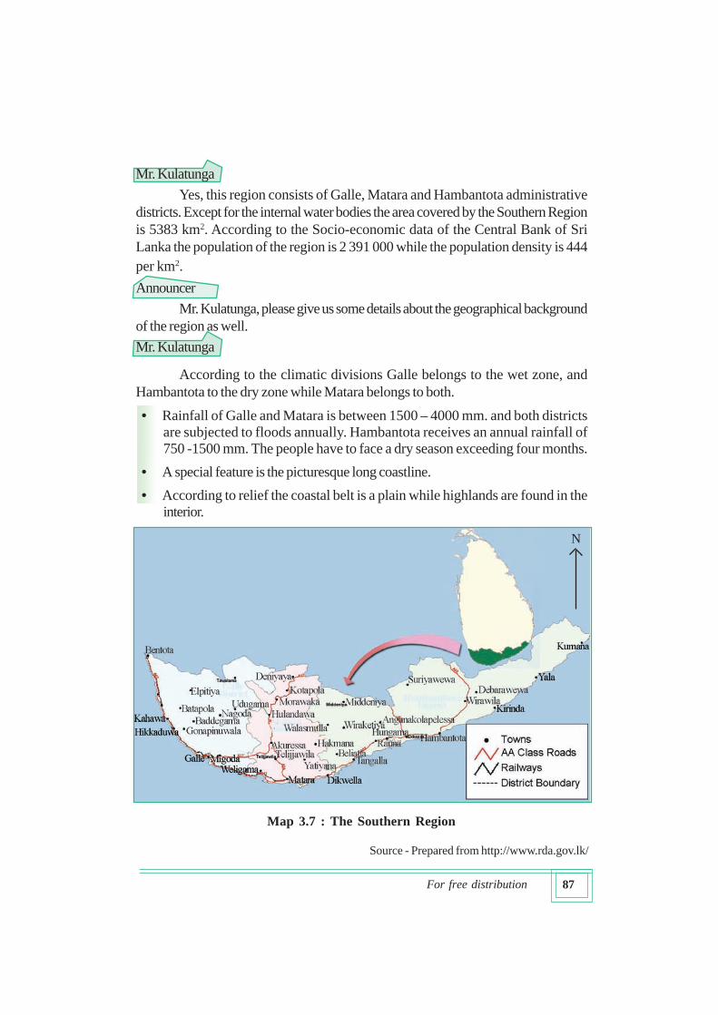
Mr. Kulatunga
Yes, this region consists of Galle, Matara and Hambantota administrative
districts. Except for the internal water bodies the area covered by the Southern Region
is 5383 km2. According to the Socio-economic data of the Central Bank of Sri
Lanka the population of the region is 2 391 000 while the population density is 444
per km2.
Announcer
Mr. Kulatunga, please give us some details about the geographical background
of the region as well.
Mr. Kulatunga
According to the climatic divisions Galle belongs to the wet zone, and
Hambantota to the dry zone while Matara belongs to both.
• Rainfall of Galle and Matara is between 1500 – 4000 mm. and both districts
are subjected to floods annually. Hambantota receives an annual rainfall of
750 -1500 mm. The people have to face a dry season exceeding four months.
• A special feature is the picturesque long coastline.
• According to relief the coastal belt is a plain while highlands are found in the
interior.
Source - Prepared from http://www.rda.gov.lk/
N
Map 3.7 : The Southern Region
88For free distribution
• Presently, the region is making new progress under the Southern Sri LankaDevelopment Plan. According to the physical environment of the region a diversityis seen in human activities. The coastal plain shows high densities of population
while highlands in the interior record low densities.
Announcer
What are the physical resources of the region?
Mr. Kulatunga
Graphite, mineral sands along coastal areas, coral and limestone, gems, kaoline
and clay suitable for tiles are found in the region. This is an area which can be developed
by rainfed cultivation as well as by providing irrigation facilities.
Activities
1. Mark and name the districts of the Southern Region of Sri Lanka in a map
showing province and district boundaries.
2. Name the climatic zones to which this region belongs.
There are a number of rural development
projects implemented in the Southern Region
:
• “Southern Province Rural Development
Project” launched in 1991 with the
assistance of the Asian Development
Bank (ADB).
• District Integrated Rural Development
Programmes with “SIDA” assistance in
Matara and with “NORAD” funding in
Hambantota.
• Rural electrification projects in the
Grama Niladhari Divisions of
Lankagama and Varukandeniya and the
thermal power station at Nadugala.
Mr. Kulatunga who provided basic information about the Southern Region
distributed many leaflets among the students to gather additional information.
With the help of those leaflets and teacher’s guidance the students classified
information about the development of the Southern Region of Sri Lanka.
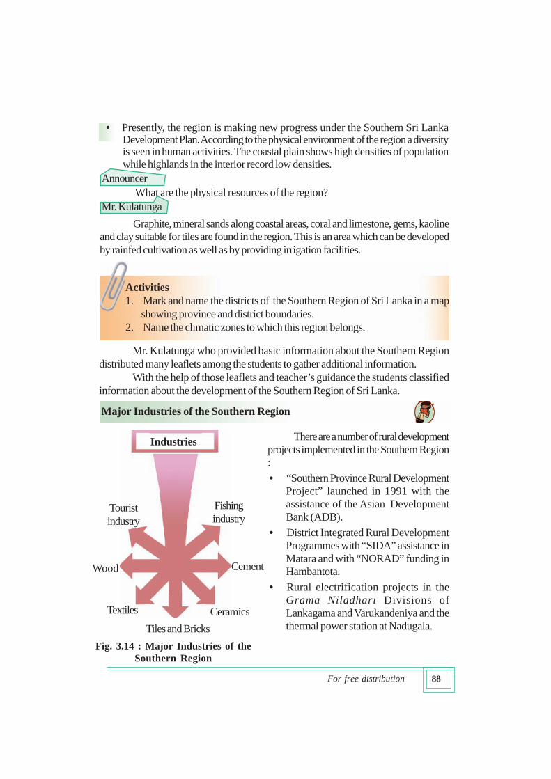
Major Industries of the Southern Region
Fig. 3.14 : Major Industries of the
Southern Region
Industries
Ceramics
Cement
Fishing
industry
Textiles
Tiles and Bricks
Tourist
industry
Wood
89For free distribution
• Construction of highways and reconstrucion of roads
• Repair of existing bridges and new constructions (Matara – Mahanama bridge)
• Minor irrigation projects
• Projects to prevent salt water intrution into lands
• Establishment of fishing villages and fishery societies
• Rearing of lobsters under the new Casita technology.
• Completion of the construction of Colombo - Matara highway up to Galle at the
end of year 2011
In addition to the above, Colombo – Matara highway is being constructed to
cut across the region while stage I of the Matara – Kataragama proposed railway line
is nearing completion up to Dikwella. All these projects were aimed to develop the
villages and village infrastructure.
Development of the Southern Region was greatly retarded because of the
tsunami disaster which occurred on 26th of December 2004. In the event many
philanthropists both local and foreign and governments gave much financial and
material support as well as technical and labour assistance to Sri Lanka. In addition,
steps were taken to demarcate a reservation of a 100 m width and develop the coastal
zone and to establish a pre-tsunami warning system. Further an accelerated
development project named Southern Lanka Development has been implemented by
the government of Sri Lanka. A re-awakening of the region was expected through the
reconstruction of destroyed road networks and harbours as well as the development
of agriculture and fisheries which were undertaken with the assistance of this project.
Try to understand the development of the Southern Region with the help of
facts organized under different headings.
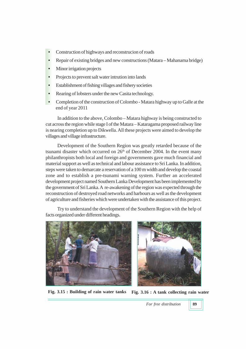
Fig. 3.15 : Building of rain water tanks Fig. 3.16 : A tank collecting rain water
90For free distribution
Development of Agriculture
• Development of coconut cultivation in the coastal belt and naming Ranna,
Tangalle and Middeniya in the Hambantota district as the mini coconut triangle
for the development of the cultivation.
• Introduction of palmyrah as a new cultivation in the Hambantota district.
• Supporting small holders in Galle and Matara districts by providing credit and
advisory services for the cultivation of tea, rubber and cinnamon.
• Extending facilities to farmers through agrarian service centres for crops such
as pepper, coffee to be grown under coconut.
• Cashew cultivation together with coconut in the Hambantota district.
Improvement of infrastructure facilities
• Rebuilding the destroyed railway line using local technology and labour
• Under the first stage of the proposed Matara-Kataragma Railway road, the
constructions has already been completed upto Dikwella by now.
• Reconstruction of destroyed roads and bridges
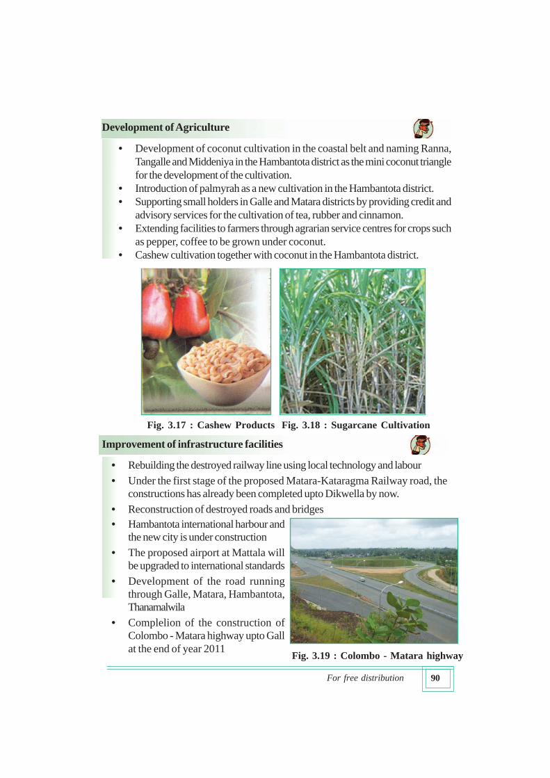
Fig. 3.17 : Cashew Products Fig. 3.18 : Sugarcane Cultivation
• Hambantota international harbour and
the new city is under construction
• The proposed airport at Mattala will
be upgraded to international standards
• Development of the road running
through Galle, Matara, Hambantota,
Thanamalwila
• Complelion of the construction of
Colombo - Matara highway upto Gall
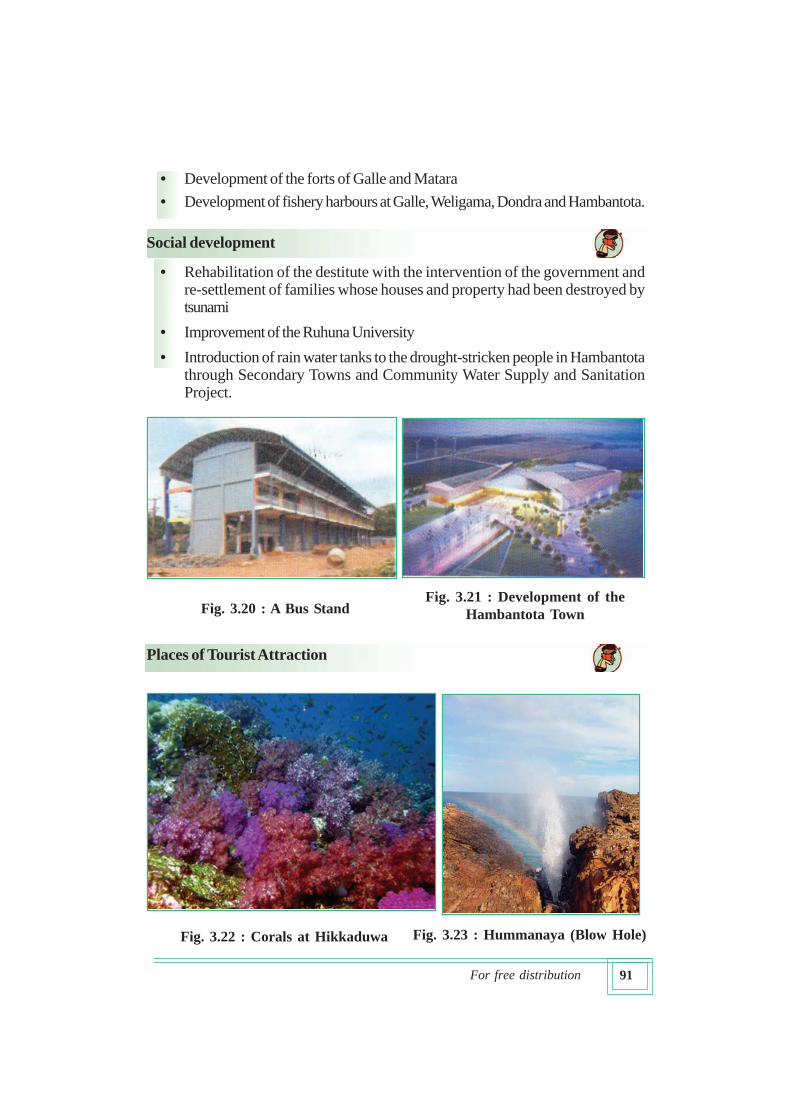
at the end of year 2011Fig. 3.19 : Colombo - Matara highway
91For free distribution
Places of Tourist Attraction
• Development of the forts of Galle and Matara
• Development of fishery harbours at Galle, Weligama, Dondra and Hambantota.
Fig. 3.20 : A Bus StandFig. 3.21 : Development of the
Hambantota Town
Fig. 3.22 : Corals at Hikkaduwa Fig. 3.23 : Hummanaya (Blow Hole)
Social development
• Rehabilitation of the destitute with the intervention of the government andre-settlement of families whose houses and property had been destroyed bytsunami
• Improvement of the Ruhuna University
• Introduction of rain water tanks to the drought-stricken people in Hambantotathrough Secondary Towns and Community Water Supply and SanitationProject.
92For free distribution
Human activities have been adapted to exploit the particular advantage of
such sites. Construction of hotels for tourists and generation of related employment
such as trading, driving and guiding could be cited as examples.
These projects also indicate that the human activities are shaped by the physical
environment of the region.
Problems faced in implementing development plans in the Southern
Region
• Problems relating to obtaining land for development activities, widening of
roads and new constructions
• Inability to attain the objectives of the Nilwala Ganga flood protection scheme
• Salinization of large extents of land
• Lowering of the ground water table
• Fallowing of old farmlands.
After work
Collect information on more development projects nearing completion in the
Southern Region under the present government.
The government has already accomplished the granting of alternative
lands and payment of compensation to those who were deprived of
their lands because of development projects.
Eastern Region
This region consists of Trincomalee, Batticaloa and Ampara districts. Eastern Province
is the largest province in Sri Lanka. Except for internal water bodies the area covered by
the Eastern Region is 9622.07 km2, which represents 14.9% (NARESA 1991) of the
total land area of the country. Population is 1,578 000 which is 7.9% of the country’s
population while the density of population is 169 per km2 (Central Bank of Sri Lanka, 2007).
Activity
Mention three reasons which are responsible for variations in development
within the Southern Region.
93For free distribution
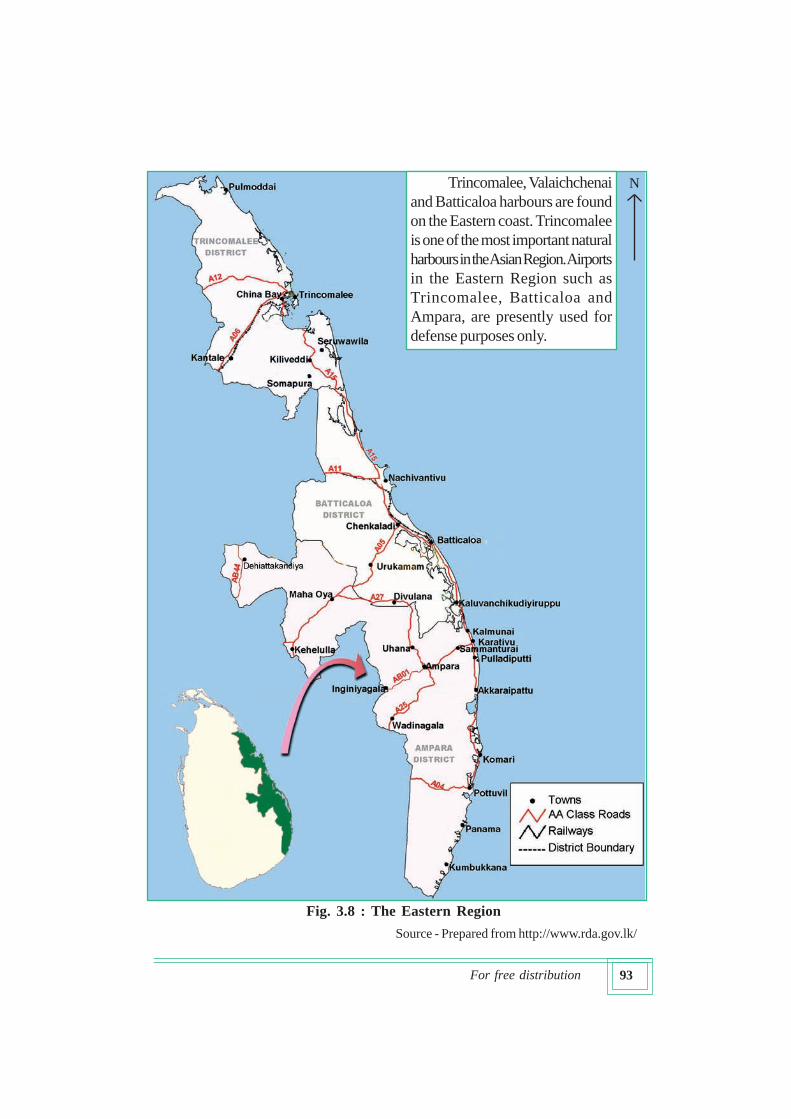
Source - Prepared from http://www.rda.gov.lk/
N
Fig. 3.8 : The Eastern Region
Trincomalee, Valaichchenai
and Batticaloa harbours are found
on the Eastern coast. Trincomalee
is one of the most important natural
harbours in the Asian Region. Airports
in the Eastern Region such as
Trincomalee, Batticaloa and
Ampara, are presently used for
defense purposes only.
94For free distribution
• Possesses a long picturesque coastline which is about ¼ the total coastline of
Sri Lanka. Majority of the coastal dwellers are engaged in fishing.
• Sinhalese, Tamils and Muslims live together in this region.
• This region possesses the largest extent of paddy land in the country. Majority
of the paddy lands fed by the Gal Oya Scheme, the first multi-purpose scheme
of Sri Lanka, are found in this region.
• As in the Northern region war situation that has prevailed in the Eastern Region
for more than two decades has retarded the development process.
Let us recognize the physical resources of the Eastern Region
• Elevation of the coastal plain is between 0 – 30m.
• Annual rainfall is between 1500 – 2000 mm.
• The drought period is from 2 to 5 months.
• Dry zone monsoon forests and mangroves near lagoons constitute the main
natural vegetation types.
• Clay and mica in the Ampara area Ilmanite in Pulmudai and live and dead
corals in the Kalkudah area are the main mineral resources. Other minerals are
not of importance in the region.
• Animal and bird sanctuaries found in association with forests are assets to the
region.
Human activities with links to the physical environment
• Paddy cultivation is fed by the Senanayake Reservoir in the Ampara district,
Mahaweli irrigation in the Trincomalee region and by small as well as large
tanks in other regions. Some areas are rainfed.
• Highlands without irrigation facilities are used for crops such as sugarcane, cashew
and dry grains.
• Wood-based industries, paper industry, fishing and related industries are among
the major industrial activities.
In the Eastern Region, as well as in the Northern Region, there had been
no industrial output owing to the war situation which prevailed for more than two
decades. Similarly, there was no significant contribution from the large paddy
tracts to the national paddy output. The tsunami disaster was another blow to
the people worsening their position. The government has taken diverse steps
to overcome such problems and promote a development similar to other
regions of Sri Lanka.
95For free distribution
There are 1,750,000 ha. suitable for paddy and 2,81,600 ha. of highlands in the
Eastern Province. This province produces 25% of the national paddy requirement.
Yet only 50 – 60% of the lands are cultivated. It is planned to cultivate
1,7,355 h.a. (42 886 acres) of fallow lands during Maha 2008 – 2009 (Ministry of
Nation Building and Estate Infrastructure Development, 2008)
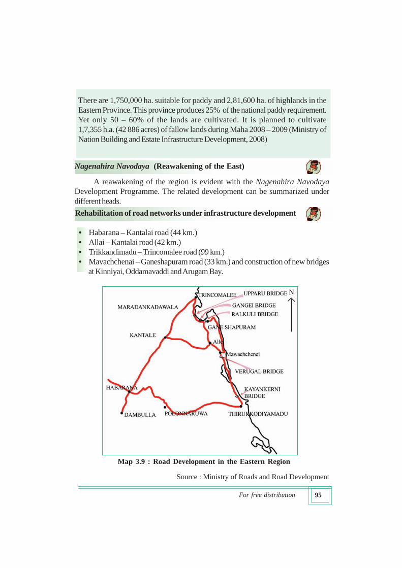
Nagenahira Navodaya (Reawakening of the East)
A reawakening of the region is evident with the Nagenahira Navodaya
Development Programme. The related development can be summarized under
different heads.
Rehabilitation of road networks under infrastructure development
• Habarana – Kantalai road (44 km.)
• Allai – Kantalai road (42 km.)
• Trikkandimadu – Trincomalee road (99 km.)
• Mavachchenai – Ganeshapuram road (33 km.) and construction of new bridges
at Kinniyai, Oddamavaddi and Arugam Bay.
Source : Ministry of Roads and Road Development
N
Map 3.9 : Road Development in the Eastern Region
96For free distribution
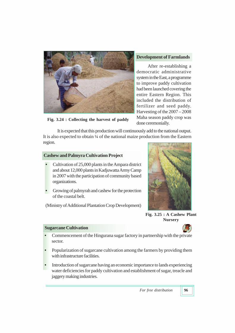
Development of Farmlands
After re-establishing a
democratic administrative
system in the East, a programme
to improve paddy cultivation
had been launched covering the
entire Eastern Region. This
included the distribution of
fertilizer and seed paddy.
Harvesting of the 2007 – 2008
Maha season paddy crop was
done ceremonially.
It is expected that this production will continuously add to the national output.
It is also expected to obtain ¼ of the national maize production from the Eastern
region.
Cashew and Palmyra Cultivation Project
• Cultivation of 25,000 plants in the Ampara district
and about 12,000 plants in Kadjuwatta Army Camp
in 2007 with the participation of community based
organizations.
• Growing of palmyrah and cashew for the protection
of the coastal belt.
(Ministry of Additional Plantation Crop Development)
Sugarcane Cultivation
• Commencement of the Hingurana sugar factory in partnership with the private
sector.
• Popularization of sugarcane cultivation among the farmers by providing them
with infrastructure facilities.
• Introduction of sugarcane having an economic importance to lands experiencing
water deficiencies for paddy cultivation and establishment of sugar, treacle and
jaggery making industries.
Fig. 3.24 : Collecting the harvest of paddy
Fig. 3.25 : A Cashew Plant
Nursery
97For free distribution
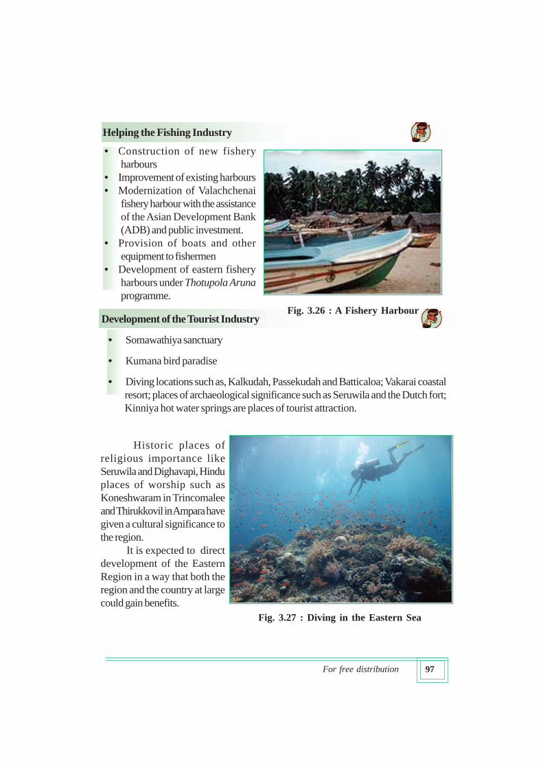
Helping the Fishing Industry
• Construction of new fishery
harbours
• Improvement of existing harbours
• Modernization of Valachchenai
fishery harbour with the assistance
of the Asian Development Bank
(ADB) and public investment.
• Provision of boats and other
equipment to fishermen
• Development of eastern fishery
harbours under Thotupola Aruna
programme.
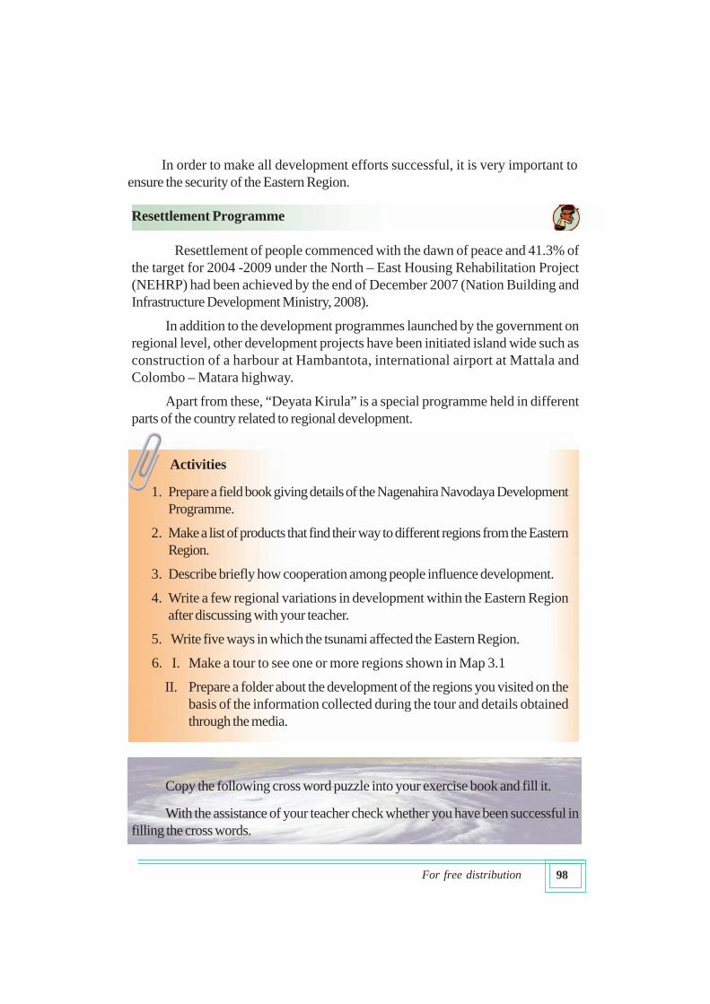
Development of the Tourist Industry
• Somawathiya sanctuary
• Kumana bird paradise
• Diving locations such as, Kalkudah, Passekudah and Batticaloa; Vakarai coastal
resort; places of archaeological significance such as Seruwila and the Dutch fort;
Kinniya hot water springs are places of tourist attraction.
Fig. 3.26 : A Fishery Harbour
Fig. 3.27 : Diving in the Eastern Sea
Historic places of
religious importance like
Seruwila and Dighavapi, Hindu
places of worship such as
Koneshwaram in Trincomalee
and Thirukkovil in Ampara have
given a cultural significance to
the region.
It is expected to direct
development of the Eastern
Region in a way that both the
region and the country at large
could gain benefits.
98For free distribution
In order to make all development efforts successful, it is very important to
ensure the security of the Eastern Region.
Activities
1. Prepare a field book giving details of the Nagenahira Navodaya Development
Programme.
2. Make a list of products that find their way to different regions from the Eastern
Region.
3. Describe briefly how cooperation among people influence development.
4. Write a few regional variations in development within the Eastern Region
after discussing with your teacher.
5. Write five ways in which the tsunami affected the Eastern Region.
6. I. Make a tour to see one or more regions shown in Map 3.1
II. Prepare a folder about the development of the regions you visited on the
basis of the information collected during the tour and details obtained
through the media.
Copy the following cross word puzzle into your exercise book and fill it.
With the assistance of your teacher check whether you have been successful in
filling the cross words.
Resettlement Programme
Resettlement of people commenced with the dawn of peace and 41.3% of
the target for 2004 -2009 under the North – East Housing Rehabilitation Project
(NEHRP) had been achieved by the end of December 2007 (Nation Building and
Infrastructure Development Ministry, 2008).
In addition to the development programmes launched by the government on
regional level, other development projects have been initiated island wide such as
construction of a harbour at Hambantota, international airport at Mattala and
Colombo – Matara highway.
Apart from these, “Deyata Kirula” is a special programme held in different
parts of the country related to regional development.

99For free distribution
Across
2. A source of water for the villages
4. Husked paddy
5. An urban place smaller than a city
8. A mode of transport
9. An important crop in the hill country
12. Cropping season which coincides with the dry season
14. Another word for stream
15. A product obtained from sea water
16. Shortened form for the Colombo Metropolitan Region
Down
1. Name of a bay in the Eastern coast
2. One of the climatic zones in Sri Lanka
3. Opposite of the word “high”
6. One of the provinces in Sri Lanka
7. Raw material for making tiles and bricks
10. One of the major sources of power
11. A coastal feature
13. Another word for “objective”
2 3 5
57 6
7
13
10
14
11
15
1A L
T
A9
S
8
A16
C
4
12
100For free distribution
Sources
YS% ,xld uy nxl=j" 2007" iudc wd¾Ól o;a;
tï ã .=Kfiak iud.u" 2003" kùk .=Kfiak ms,sma f,dal is;shï fmd;
wOHdmk m%ldYk fomd¾;fïka;=j" 1998" Wiia fm< udkqI N+f.da, úoHdj I
YS% ,xld uyje,s wêldßh" m%.;s md,k tAllh" 2005 ixLHd f,aLk
cd;sl c,iïmdok yd c,dmjdyk uKav,h" jeisÈh /ialsÍfï ;dlaIKh iy
jeisc, /|jqï gexls kv;a;=j ms<sn| (Èkh i|yka fkdjk) w;afmd;
w;sf¾l jeú,s fnda. ixj¾Ok wud;HdxYh" Wla ;,a yd lcq ;s%;ajh cd;sl
;,hg ^Èkh i|yka fkdjk& w;am;s%ld
kd.ßl ixj¾Ok wêldßh" 2009" kd.ßl ixj¾Ok yd mQcdN+ñ ixj¾Ok
wud;HdxYh" w;am;s%ld
uyd ud¾. yd ud¾. ixj¾Ok wud;HdxYh" 2009 fmnrjdß 17 ÈkñK" ishjil
cd;sl fufyjr w;sf¾lh
Abhayaratna, M.D.C., 2005, “Regional Development Implications of the Accelerated
Mahaweli development Project”, in M.M. Karunanayake and Anders Narman (Eds)
Regional Development in Sri Lanka: Resetting the Agenda, University of Sri
Jayewardenepura, Sri Lanka.
Natural resources. Energy and Science Authority of Sri Lanka, (NARESA), 1991,
Natural resources of Sri Lanka, Conditions and Trends.