Embed Size (px)
Citation preview
IFHP 55th World Congress Tallinn 13 September, 2011
Spatial Management and Planning Methods for Urban Fringe
- A Case Study of Raigad district, Mumbai metropolitan region, India -
Minsun Kim International Development and Regional Planning Unit
Department of Urban Engineering, The University of Tokyo
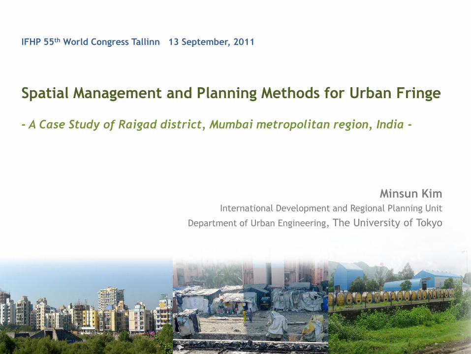
Ⅰ. Introduction
- Background, Objectives, Outline of study area
Ⅱ. Spatial Analysis on Land use change
Ⅲ. Review on Planning and Development control system
Ⅳ. Clarification of Urbanization effect and Urban-Rural Linkage
- Case study on rural villages
Ⅴ. Conclusion and Findings
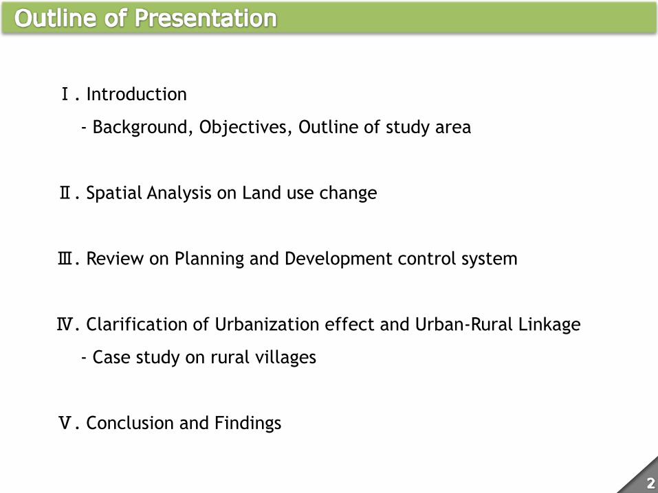
Challenges of Peri-Urbanization
− Asian megacities have experienced urban growth at an explosive pace.
− Decentralization for balaced regional development → Centralization for making
competitive city in the global economy
− Social and economic negative consequences and disparities between urban and rural area
in metropolitan region. Rural: human quality of life and agriculture environment degradation, new type of immigrants from
remote rural area..
Urban: pollution, congestion, informal employment and settlement..
− Developing countries: Irrational land ownership and poorly planned and managed land
use and development
Integrated management system beyond the urban-rural boundary for a better
balanced metropolitan region development
Role of Peri-urban, rural space
− For urban residents: fresh and low-cost agricultural production, recreation,
environmental relaxation...
− For rural residents: stable consumer market, access to the goods and materials, side-job
opportunity...
Institutional and planning support to increase benefits from co-existence for
strenthening urban-rural linkage in metropolitan area
Situation of Asian Countries
− Compressed growth: began to establish their national infrastructure and governance after
independence
− Colonial city: well-resourced primacy cities in the colonials era, e.g. Seoul, Shanghai,
Mumbai, became the bases of economic growth
− MEGAcities: 7 out of 10 world’s biggest metropolitan regions are in Asia based on the
population criteria
− Changes in land use: land markets are experiencing competitive pressure as urban center
expand and satellite towns are developed, speculation is frequent
− Aging and decreasing rural (agricultural) population: in case of Japan, agricultural
population is only 3.5, 60% of those are over 65. abandoned agricultural land
− Urban residents’ growing interest in agriculture: weekend house in suburban area, public
farms, involvement in activities to support farmers
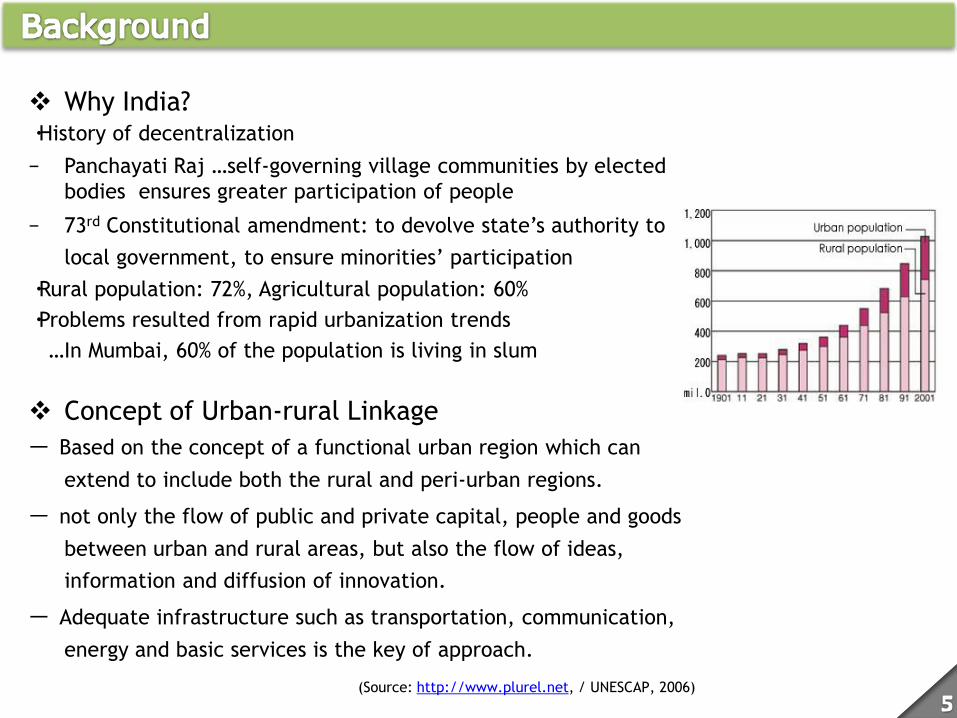
Why India? ・History of decentralization
− Panchayati Raj …self-governing village communities by elected
bodies ensures greater participation of people
− 73rd Constitutional amendment: to devolve state’s authority to
local government, to ensure minorities’ participation
・Rural population: 72%, Agricultural population: 60%
・Problems resulted from rapid urbanization trends
…In Mumbai, 60% of the population is living in slum
Concept of Urban-rural Linkage
ー Based on the concept of a functional urban region which can
extend to include both the rural and peri-urban regions.
ー not only the flow of public and private capital, people and goods
between urban and rural areas, but also the flow of ideas,
information and diffusion of innovation.
ー Adequate infrastructure such as transportation, communication,
energy and basic services is the key of approach.
(Source: http://www.plurel.net, / UNESCAP, 2006)
1. Analysis on long-term trends in land-use change and clarify
various factors which have influenced spatial pattern of
urban expansion in Mumbai metropolitan region
2. Review the development control system (acts, regulations
and organizational structure) operated within the context of
the preservation of agricultural land
3. Case study on suburban villages in Panvel block, Raigad district
to reveal urbanization effects on the local economy and
characteristics of existing urban-rural linkage
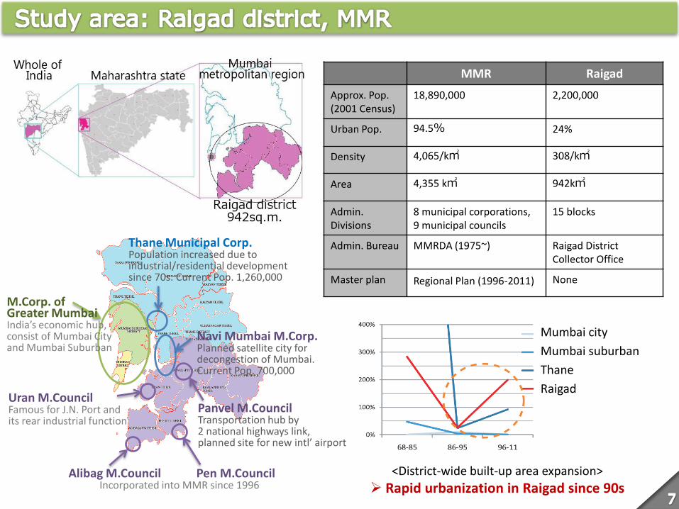
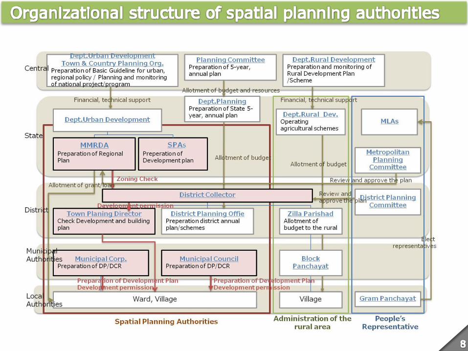
Thane Municipal Corp. Population increased due to industrial/residential development since 70s. Current Pop. 1,260,000
Navi Mumbai M.Corp. Planned satellite city for decongestion of Mumbai. Current Pop. 700,000
Panvel M.Council Transportation hub by 2 national highways link, planned site for new intl’ airport
Uran M.Council Famous for J.N. Port and its rear industrial function
Alibag M.Council Pen M.Council Incorporated into MMR since 1996
M.Corp. of Greater Mumbai India’s economic hub, consist of Mumbai City and Mumbai Suburban
MMR Raigad
Approx. Pop. (2001 Census)
18,890,000 2,200,000
Urban Pop. 94.5% 24%
Density 4,065/k㎡ 308/k㎡
Area 4,355 k㎡ 942k㎡
Admin. Divisions
8 municipal corporations, 9 municipal councils
15 blocks
Admin. Bureau MMRDA (1975~) Raigad District Collector Office
Master plan Regional Plan (1996-2011) None
<District-wide built-up area expansion>
Rapid urbanization in Raigad since 90s
Mumbai city
Mumbai suburban
Thane
Raigad
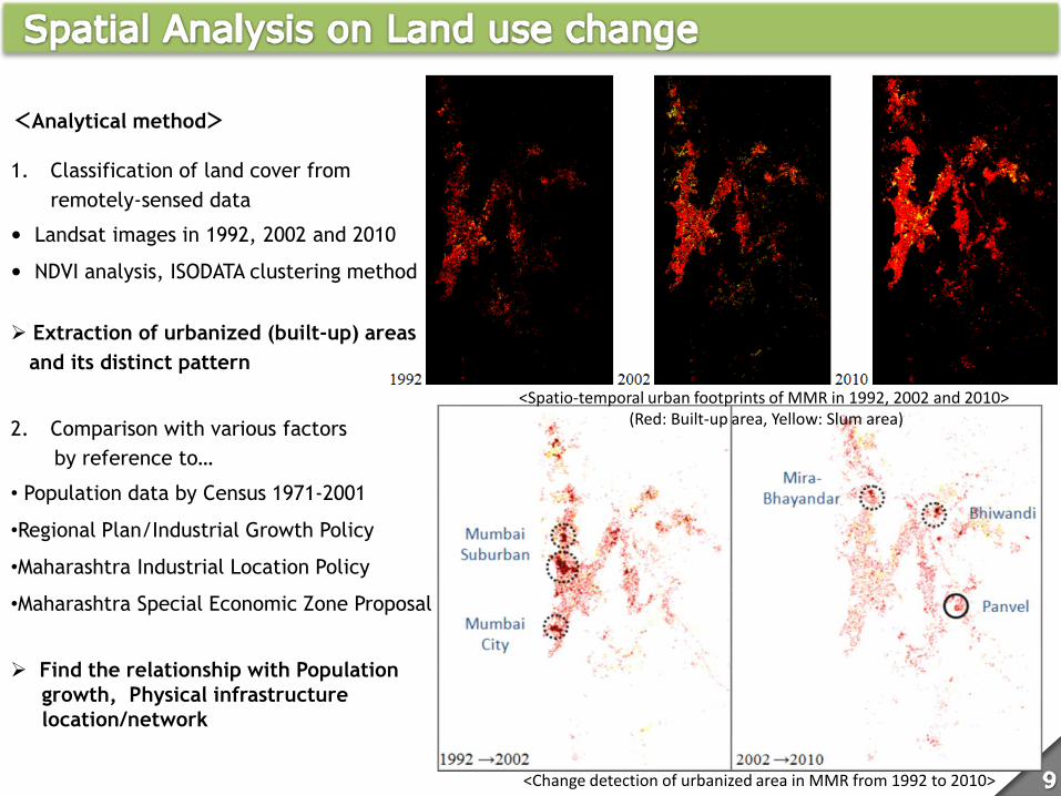
<Analytical method>
1. Classification of land cover from
remotely-sensed data
• Landsat images in 1992, 2002 and 2010
• NDVI analysis, ISODATA clustering method
Extraction of urbanized (built-up) areas
and its distinct pattern
2. Comparison with various factors
by reference to…
• Population data by Census 1971-2001
•Regional Plan/Industrial Growth Policy
•Maharashtra Industrial Location Policy
•Maharashtra Special Economic Zone Proposal
Find the relationship with Population
growth, Physical infrastructure
location/network
<Spatio-temporal urban footprints of MMR in 1992, 2002 and 2010> (Red: Built-up area, Yellow: Slum area)
<Change detection of urbanized area in MMR from 1992 to 2010>
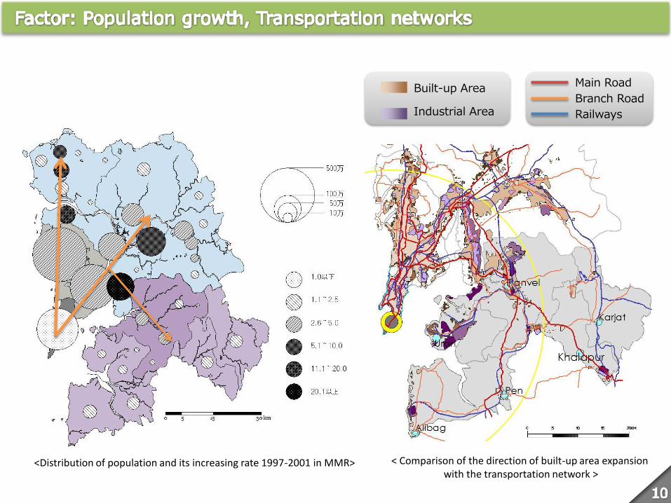
<Distribution of population and its increasing rate 1997-2001 in MMR>
Built-up Area
Industrial Area
Main Road
Branch Road
Railways
< Comparison of the direction of built-up area expansion with the transportation network >
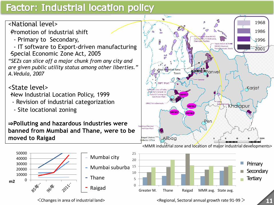
<MMR industrial zone and location of major industrial developments>
0
10000
20000
30000
40000
50000
m2
旧市街地
サバーバン
ターネ県
ライガド県
<National level> ・Promotion of industrial shift
- Primary to Secondary,
- IT software to Export-driven manufacturing ・Special Economic Zone Act, 2005 “SEZs can slice off a major chunk from any city and
are given public utility status among other liberties.”
A.Vedula, 2007
<State level> ・New Industrial Location Policy, 1999
- Revision of industrial categorization
- Site locational zoning
⇒Polluting and hazardous industries were
banned from Mumbai and Thane, were to be
moved to Raigad
<Changes in area of industrial land>
1968
1986
1996
2001
Mumbai city
Mumbai suburban
Thane
Raigad
Primary Secondary Tertiary
Greater M. Thane Raigad MMR avg. State avg.
<Regional, Sectoral annual growth rate 91-99 >
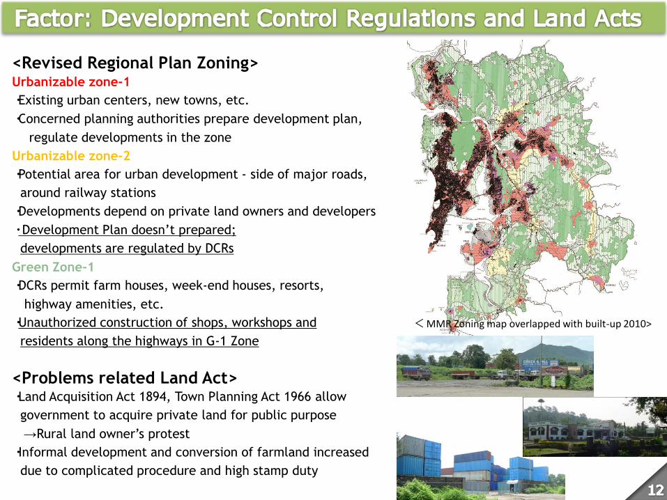
<Revised Regional Plan Zoning> Urbanizable zone-1
・Existing urban centers, new towns, etc.
・Concerned planning authorities prepare development plan,
regulate developments in the zone
Urbanizable zone-2
・Potential area for urban development - side of major roads,
around railway stations
・Developments depend on private land owners and developers
・ Development Plan doesn’t prepared;
developments are regulated by DCRs
Green Zone-1
・DCRs permit farm houses, week-end houses, resorts,
highway amenities, etc.
・Unauthorized construction of shops, workshops and
residents along the highways in G-1 Zone
<Problems related Land Act> ・Land Acquisition Act 1894, Town Planning Act 1966 allow
government to acquire private land for public purpose
→Rural land owner’s protest
・Informal development and conversion of farmland increased
due to complicated procedure and high stamp duty
< MMR Zoning map overlapped with built-up 2010>
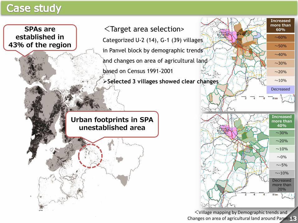
SPAs are established in
43% of the region
Urban footprints in SPA unestablished area
Increased more than
60%
~60%
~50%
~40%
~30%
~20%
~10%
Decreased
Increased more than
40%
~30%
~20%
~10%
~0%
~-5%
~-10%
Decreased more than
20%
<Village mapping by Demographic trends and Changes on area of agricultural land around Panvel>
<Target area selection>
Categorized U-2 (14), G-1 (39) villages
in Panvel block by demographic trends
and changes on area of agricultural land
based on Census 1991-2001
Selected 3 villages showed clear changes
Karnala Barapada
Dolghar
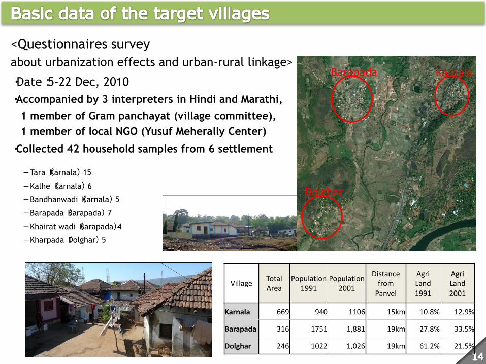
<Questionnaires survey
about urbanization effects and urban-rural linkage>
・Date:5-22 Dec, 2010
・Accompanied by 3 interpreters in Hindi and Marathi,
1 member of Gram panchayat (village committee),
1 member of local NGO (Yusuf Meherally Center)
・Collected 42 household samples from 6 settlement
-Tara(Karnala) 15
-Kalhe(Karnala) 6
-Bandhanwadi(Karnala) 5
-Barapada(Barapada) 7
-Khairat wadi(Barapada)4
-Kharpada(Dolghar) 5
Village Total Area
Population 1991
Population 2001
Distance from
Panvel
Agri Land 1991
Agri Land 2001
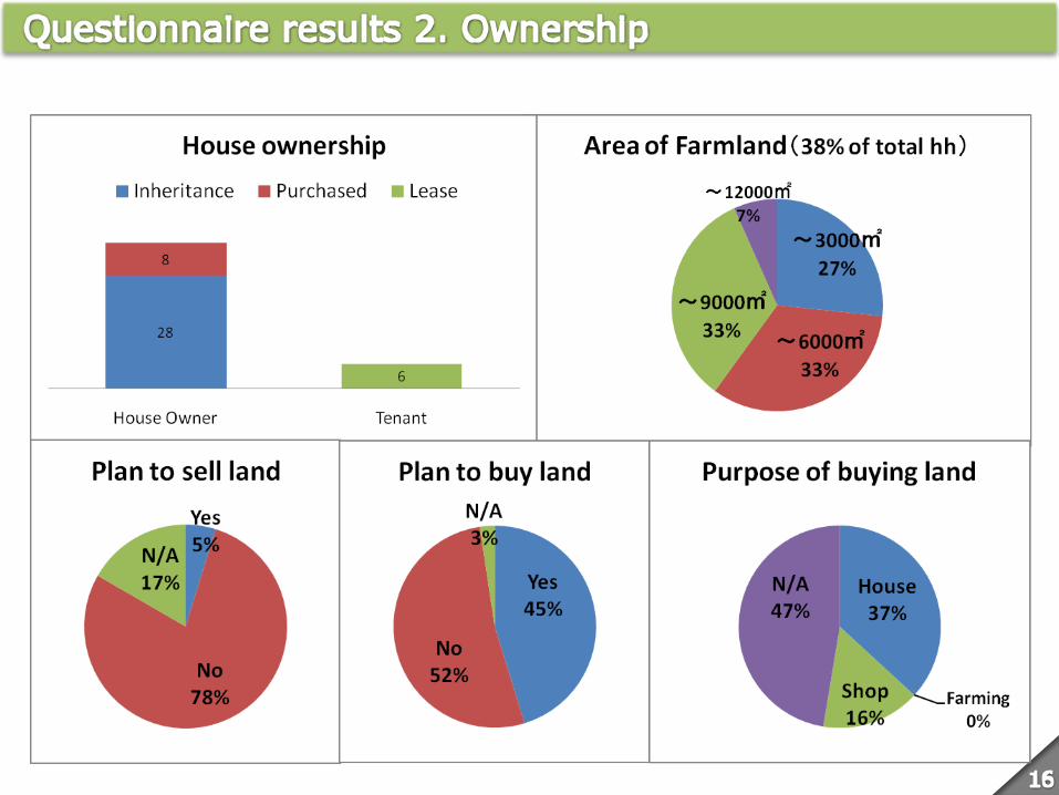
Karnala 669 940 1106 15km 10.8% 12.9%
Barapada 316 1751 1,881 19km 27.8% 33.5%
Dolghar 246 1022 1,026 19km 61.2% 21.5%
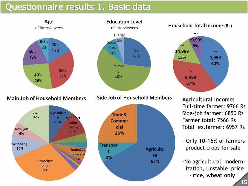
Agricultural Income:
Full-time farmer: 9766 Rs
Side-job farmer: 6850 Rs
Farmer total: 7566 Rs
Total ex.farmer: 6957 Rs
- Only 10-15% of farmers
product crops for sale
-No agricultural modern-
ization, Unstable price
→ rice, wheat only
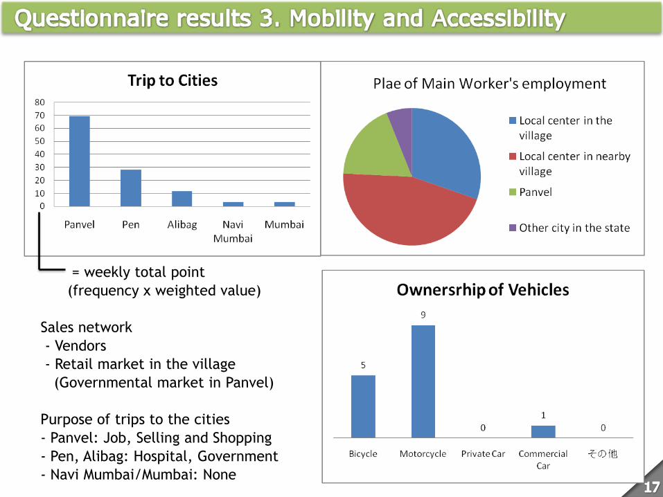
= weekly total point
(frequency x weighted value)
Sales network
- Vendors
- Retail market in the village
(Governmental market in Panvel)
Purpose of trips to the cities
- Panvel: Job, Selling and Shopping
- Pen, Alibag: Hospital, Government
- Navi Mumbai/Mumbai: None
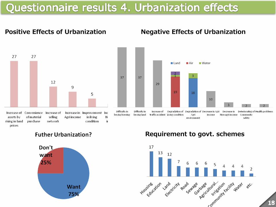
Positive Effects of Urbanization 都市化による悪影響
Negative Effects of Urbanization
Requirement to govt. schemes
1. Transportation networks, industrial and residential(New Town) enclaves, deregulation
of zoning/development control regulations, irrational land acts and procedures served
as a trigger of urban sprawls, especially in the areas outside SPA boundary
2. In general, the connections with urban area appeared to be weak due to lack of
mobility. Connection with the neighbor small and medium-sized cities was stronger
than large cities. However, employment connection with the small and medium-sized
cities was weak.
3. In case of remote village, residents especially tenants and non-farmers tend to
indicate negative effects of urbanization rather than positive effects.
4. New movement: highly-educated people of the younger generation have different
pattern of employment and connection to the cities.
Suggestions: Agricultural intensification and organization
Opportunity for extra earning from increasing tourism demand


![ftYgk %& jk;xM lu 2000 fiMhr - Raigad Policeraigadpolice.gov.in/pdfdocs/Raigad District Atrocity Info. of the... · ftYgk %& jk;xM lu 2000 vuqlwfpr tkrh] vuqlwfpr tekrh o ukxjh gDd](https://img.pdfslide.us/doc/110x75/5c7abe6009d3f264308b598b/ftygk-jkxm-lu-2000-fimhr-raigad-district-atrocity-info-of-the-ftygk.jpg)