Embed Size (px)
Citation preview

CIIAPTER.2
PROF"ILE OF RAIGAD DISTRICT
2.1 Introduction
The potential as well as realized growth of small-scale industries depends
upon the geographical features of the reglon. These features determine the nature
and growth of industries, which shows the impact on the industrial development
of the region. Therefore, it becomes necessary to understand the main
geographical features of the region under study as a background for the analysis
of the phenomenon to be probed into.
2.2 Historical Background: -
The narrow belt between the Arabian Sea and Satryadree Mountain range
is known as 'Konkan'. Konkan is a part of Maharashha located at the west bank
of Indiq which coven 720lffi. seashore area, which includes Mumbai, Thane,
Raiga4 Ratnagri and Sindhudurga districts are the parts of konkan.
In the ancient books of Pleeni, Tolemi, and Stabee there are mentions
about tbe Konkan. The Satwahanas in the first Century, Kalchuri Kings in the
fourth and fifth Century, Chalukya, and Shilatrar in the seventh Century ruled the
Konkan. Muslimnrlers Bahamani, Adilshatri and Nijamshatri etc. ruled from 13ft
Century to 166 Century. In the beginning of the 166 Century Portuguese came in
1(snkan followed by British and Dutch as rulers.l
34

Duing Shivaji Maharaja Regrme special importance was given to the
konkan and brought his capital place to Raigad. He built number of forts and
fought with Mugals, Britishers and Portuguese.
The history of Raigad is very interesting. Raigad is known in all over
India as the empire of the Chatrapati Shivaji Maharaja. Raigad fort is the capital
place located at 'Pachad' near Mahad. On ltt Jan. 1981 this district was renamed
as Raigad. Earlier it was known as 'Kulaba'.2
In the 56 and 6e Century Raigad was under the dominance of Mouryas.
Thereafter Adilshatri, Mugals, Portuguese and Habashies ruled this area. In
1756, Britishers entered and kept this province under their control. In 1969,
separate Kulaba district was formed.
The History of Raigad as is available from the 'Iron Era' Mourya,
Satwahan, Kshatrap, Tarikutalq Kalchui, Chalukya, Rashtrakug Shilahar,
Bahamani, Nijamshatri, Siddhi, Marathe, Angre and Britishers ruled this area It
is clear from tlrc available sources that the 'Buddha culture' was deeply rooted in
this area. In 1818, when Peshwai come to an end, the British Government
acquired the Kulaba area.
Duing the freedom stnrggle, Raigad occupied a place of revolutionary
activities and social reforms. In this district number of great activists like Naga
Katkari, Hhg Guruji, vasudev Balwant Phadke, Bhai Kotwal, Nana patil
played an important role in the freedom movement. In the Quit India Movement
Raigad was on the front.3
35
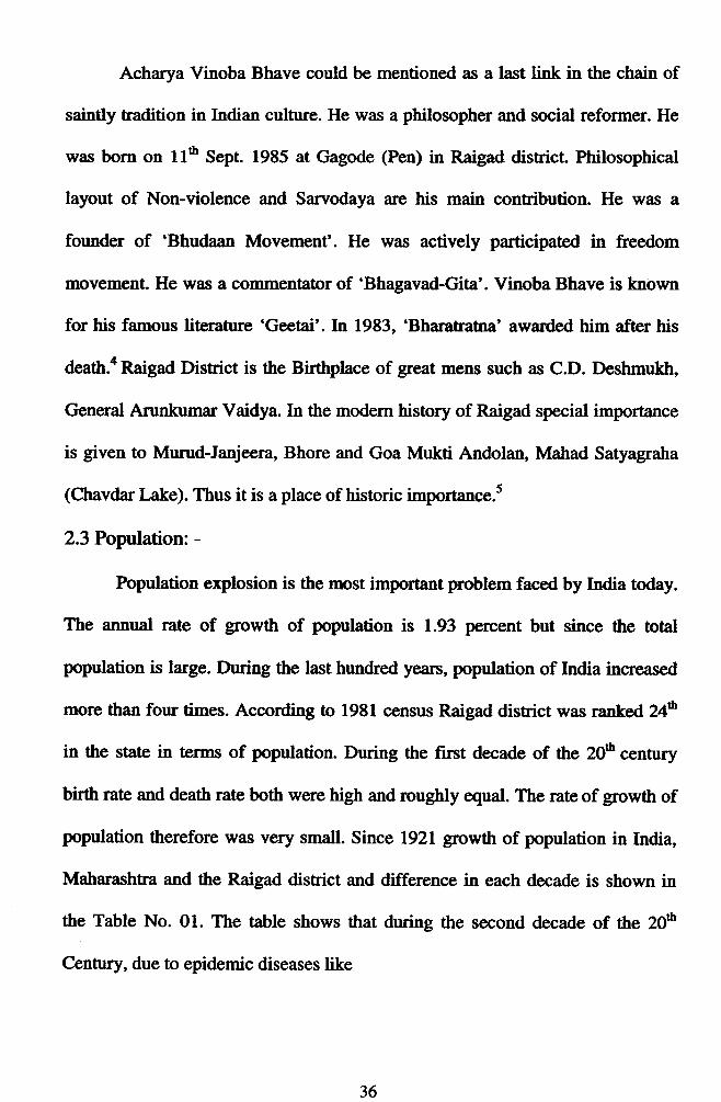
Acharya Vinoba Bhave could be mentioned as a last link in the chain of
saintly tradition in Indian culture. He was a philosopher and social reformer. He
was born on 116 Sept. 1985 at Gagode (Pen) in Raigad dishict. Philosophical
layout of Non-violence and Sarvodaya are his main contribution. He was a
founder of 'Bhudaan Movement'. He was actively participated in freedom
movement. He was a commentator of 'Bhagavad-Gita'. Vinoba Bhave is known
for his famous literature 'Geetai'. In 1983, 'Bharatratna' awarded him after his
death.a Raigad Dishict is the Birtlrplace of great mens such as C.D. Deshmukh,
General Arunliumar Vaidya. In the modern history of Raigad special importance
is given to Munrd-Janjeera, Bhore and Goa Mukti Andolan, Matrad Satyagraha
(Chavdar Lake). Thus it is a place of historic importance.s
2.3 Population: -
Population explosion is the rmst important problem faced by India today.
The annual rate of growth of population is 1.93 percent but since the total
population is large. During the last hundred years, population of India increased
nrorie than four times. According to 1981 census Raigad district was ranked 2fb
in the state in terms of population. During the first decade of the 20e century
birth rate and death rate both were high and roughly q1ual. The rate of growth of
population therefore was very small. Since 1921 growth of population in India,
Maharashtra and the Raigad district and difference in each decade is shown in
the Table No. 01. The table shows that during the second decade of the 206
Centur5r, due to epidemic diseases like
36

Table No.2.l
Growth of Population in India, Maharashtra and Raigad
Source: - Maharashtra state Gazetteer, Raigad District (1991) and Director ofEconomic and Statistics. Government of Matrarashtra (2002-03).
Year Population Decadat Growfn Vo
Indla Itflaharashtra Rdsd Indio Maharashtra Raignd
tvzl 25.r3 2.O8 677,586.n c) 3.0o G) 3.00 (-) 5.ls
1931 n.89 2.N 756,315.00 (+) 11.00 (+) 15.00 (+) rr.62
t94l 31.86 2.68 805,157.00 14.2 12.00 6.46
1951 36.10 3.20 909,083.00 13.3 19.25 12.9r
t961l 43.90 3.69 1,058,855.00 2t.5 23.ffi r6.48
rnt: 54.80 5.(X 1,263,003.00 24.8 27.50 19.28
19E1 68.50 6.28 1,48,6,452.n 24.7 71.50 17.69
ty)l u.36 7.89 1,814,628.00 23.5 25.50 22.O8
?.wl toz.70 9.67 2,205,972.W 21.34 23.N 20.89
37
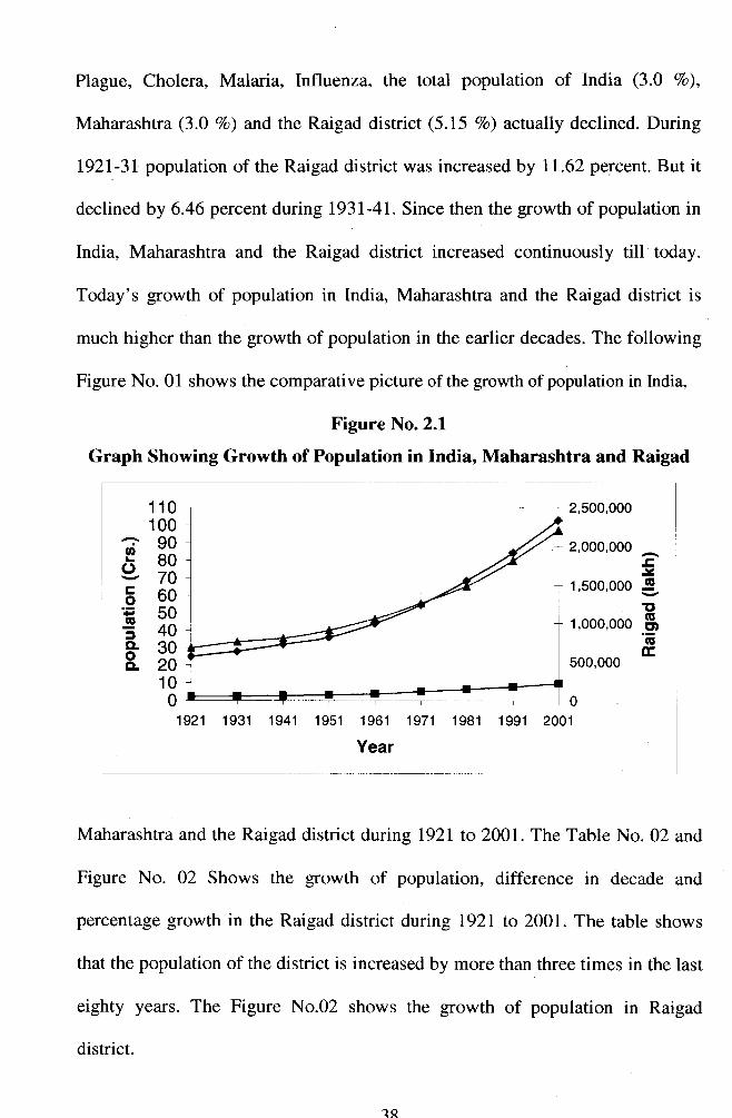
Plague, Cholera, Malaria, Influenza, the total population of India (3.0 7o),
Maharashtra (3.0 %o) and the Raigad district (5.15 Vo) actually declined. During
l92l-31 population of the Raigad district was increased by 11.62 percent. But it
declined by 6.46 percent during l93l-41. Since then the growth of population in
India, Maharashtra and the Raigad district increased continuously till today.
Today's growth of population in India, Maharashtra and the Raigad district is
much higher than the growth of population in the earlier decades. The following
Figure No. 01 shows the comparative picture of the growth of population in India,
Figure No.2.1
Graph Showing Growth of Population in India, Maharashtra and Raigad
-cJstt(u
.9oE
110100
P33v70560E?3H33
100
1
092't 1931 1941 1951 1961 1971 1981 1991 2001
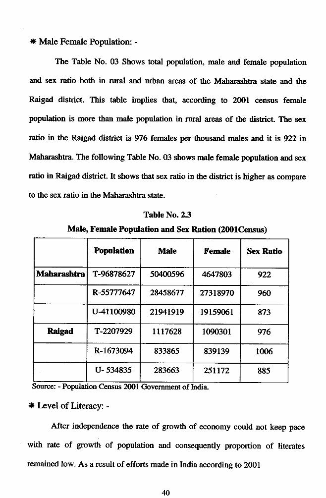
Year lMaharashtra and the Raigad district during l92l to 2001. The Table No. 02 and
Figure No. 02 Shows the growth of population, difference in decade and
percentage growth in the Raigad district during 1921 to 200I. The table shows
that the population of the district is increased by more than three times in the last
eighty years. The Figure No.02 shows the growth of population in Raigad
district.
;;; ]2,000,000
1,500,000
1,000,000
500,000
1R

Table No.2.2Growth of Population in Raigad District
Source: - Matrarashha State Gazetteer, Raigad District (4ffiEconomic and Statistics. Government of Maharashtra (200243).
Figure No. 2.2
Graph Showing Growth of Population in Raigad District
Year Population Dilference in decade Percentage
tyzl 677,596.00 -36785 -s.15
1931 756,315.00 78729 tt.62lgtll 805,157.00 488r',2 6.M
1951 909,083.00 r03926 12.9r
llr6l 1,058,855.00 r4yt72 1648
tnr 1,263,003.00 204-148 19.28
198r 1,486,452.W 22349 17.69
t99l 1,814,629.00 328t76 22.08
2001 2,205,n2.00 391344 20.89
Eoa-o-3o.oo.
2,50O,000
2,(X)0,(X)0
1,5(n,000
1,000,000
5(X),000
0
1941 1951 1961 1971
Year
1921 19it1 1981 1991
39
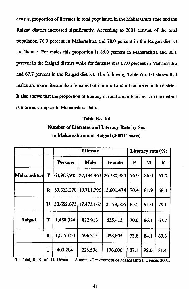
* Male Female Population: -
The Table No. 03 Shows total population, male and female population
and sex ratio both in nral and urban areas of the Maharashtra state and the
Raigad district. This table implies that, according to 2001 census female
population is more than male population in rual areas of the district. The sex
ratio in the Raigad district is 976 females per thousand rnales and it is 922 n
Maharashtra. The following Table No. 03 shows male female population and sex
ratio in Raigad district. It shows that sex ratio in the district is higher as compare
to the sex ratio in the Matrarashtra state.
Table No.23
MaIe, Female Population and Sex Ration (2fi)lCensus)
Population Male Female Sex Ratio
Maharashtra T-96878627 5(X00596 4647803 922
R-55777&7 2U58677 27318970 960
u4r 100980 219419t9 19r59061 873
Raigad T-22W929 llt7628 1090301 976
R-r673W4 833865 839139 1m6
u- 534835 283663 251t72 885
Source: - Population Census 2001 Government of India
* I*vel of Literacy: -
After independence the rate of growth of economy could not keep pace
with rate of growth of population and consequently proportion of literates
remained low. As a result of efforts made in India according to 2001
40
census, proportion of literates in total population in the Maharashtra state and the
Raigad district increased significantly. According to 2001 census, of the total
population 76.9 percent in Matrarashtra and 70.0 percent in the Raigad district
are literate. For males this proportion is 86.0 percent in Maharashtra and 86.1
percent in the Raigad district while for females it is 67.0 percent in Matrarashtra
and 67.1 percent in the Raigad district. The following Table No. 04 shows that
males are more literate than females both in rural and urban areas in the district.
It dso shows that the proportion of literacy in nral and urban are:rs in the district
is more as compare to Matrarashtra state.
Table No.2.4
Number of Literates and Literacy Rate by Sex
in Maharashtra and Raigad (2fillCensus)
T- Total, R- Rural, U- Urban Source: -Government of Maharashtra Census 2001.
Literate Litemcy rate(7o)
Persons Male Female P M F
Maharashtra T 63,965,943 37,18r'',963 26,780,990 76.9 86.0 67.O
R 33,313,270 19,711,796 13,ffit,474 70.4 81.9 58.0
U 30,652,673 17,473,167 13,179,506 85.5 91.0 79.1
Raigad T 1,458,32/+ 822,913 635,413 70.0 86.1 67.7
R 1,055,120 596,315 45g,go5 73.8 84.1 63.6
U 403,2M 226,599 176,6M 87.1 92.O 81.4
4l
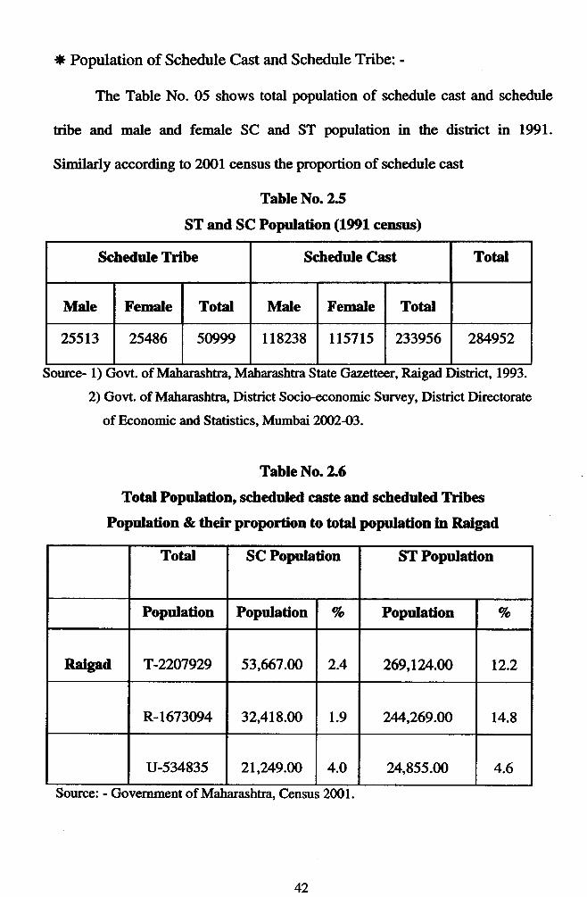
+t Population of Schedule Cast and Schedule Tribe: -
The Table No. 05 shows total population of schedule cast and schedule
tribe and male and female SC and ST population in the district in 1991.
Similarly according to 2fi)1 census the proportion of schedule cast
Table No. 25
ST and SC Poprlation (1991 census)
Schedule Tribe Schedule Cast Total
Male Female Total Male Female Total
25513 25486 sog99 118238 ll5715 233956 28r'952
Source- 1) Govt. of Maharashtra Maharashtra State Gazetteer, Raigad District, 1993.
2) Govt. of Maharashtra Dishict Socio-economic Survey, District Directorate
of Economic and Statistics, Mumbai 20fJf243.
Table No 2.6
Total Populadon, scheduled caste and scheduled Trib€s
Population & their prolnrtion to total population in Raigad
Total SC Population ST Population
Population Population Vo Populafron Vo
Raigad T-2207929 53,667.N 2.4 269,IU.AO 12.2
R-1673D4 32,418.4O 1.9 74,269.0O 14.8
u-534835 21,249.O0 4.O 24,855.00 4.6
Source: - Government of Matrarashtra, Census 2001.
42
and schedule tribe population to total population in the district is shown in the
Table No. 06.
The above table shows tbat according to 20Ol census the population of
schedule cast and schedule tribe is increased significantly as compared to 1991
census. It also implies that the schedule tribe population is more than the
schedule cast population. This is mainly because of the tribal area mostly the
katkari.
*Occupational Stnrcture of the Population: -
Proportion of people engaged in various types of occupations in the
district is an important economic aspect of population. Economic activities can
be grouped into three categories namely Primary, Secondary and Tertiary. The
Table No. 07 shows distribution of total workers by category in the district. It is
indicates that of the total workers 48.4 percent worters are engaged in other
activities, 28.6 percent workers in cultivation, 20.4 percent workers in
agriculnre and, 2.6 percent workers are engaged in household industries.
Approximately 50 percent workers are engaged in occupations related to
agriculture. This also shows that growth of secondary sector in the Raigad
district is limited. Raigad district underwent rapid indushialization especially
after 1960. Because of this proportion of workers engaged in secondary and
tertiary sector activities increased. Same trend is likely to continue in near future.
43

s?c)
Jo
Fqc.!CA
olC-
@\n
ei\o9\n
n\ao\
Fr.(q
oo$ tr-
c?)
qcflo\
.EES22ng 9'ELF.-=1(A;SEPr{ Et{
tu c.!(fl
qc\
cl\o
cooi
v?C!
o\
F{ \c\l
\(\ 9c{
qtro€6tFl?aEEe€iva(.).Ea04,
tE{ c.iCA
rn(n \-f
qca
qoo
ca
Fr-qoC\
\nc\
o\
Ba
(afio€ct
3t(J
,1qo$
\$
oeCA
oq
(\lq€c\
q
A 9ooC\l
d]\nca
C-
akq)5,oF6l-oF
frolrnOrnolc.t
o\C.lto\C\l
\oC-Oca
co.f,o\aoooIN
ca.+of-c.t$
Ooo\rn
0{o\o\coFio\
.fcoca
c.)f-
\o\o€F{
F & J
l(al(t)lal
HIflr
U'c)Crl
I
ct)Iook0)AAi
cl€t{D
Ip
=&t.
&jGI
ot-'t
IF.joo6lctrc
orn
=ct)tr(l)(J
I
irt(.)l-r
=oa
+atht'.A
a€6la06tfr
,rou0Eer: 9
^i Cf()dzE.9?-ci (uE't.aihF-O
F6tJo
F{crroEoT)€h(a
o
44

* Rural and Urban Population: -
If we look at the history of settlement in Raigad, we see that some factors
and events have played a major role in the process of urbanization. Religious,
cultural, political, and economic facton played a very important role in the
growth of cities in different parts of the district. Urbanization was helped by
industrialization. During the last fifty years the percentage of urban population
increased significantly. The Table No. 08 shows the percentage of nral and
urban population during 1951 to2001. The above table shows that by 1991 the
percentage of urban population is increased from 10.56 percent tol7.84 percent.
As a result of growth of urban population number of cities is increased from 12
to 26 in 2001. On the contrar5/, the percentage of rural population is declined
over the years.
Iable No.2.8
Rural and Urban Populadon in Raigsd District
Year Vo Of Rural Population Vo OlUrban PoprlationNumber of
Cities
1951 89.4 10.56 t2
t96l 89.92 10.08 t2
tvtl 87.92 12.08 t4
1981 85.88 14.r2 t6
t99l 82.16 t7.84 t9
zmtl N.A. N.A. 26
Source: -1) Govt. of Maharashtr4 Maharashtra State Gazettee4 Raigad Oistrict, tq9l.2) Gofi. of Maharashtra, District Socio-economic Survey, District Directorate ofEconomic and Statistics, Mumbai 2W2-O3"
45
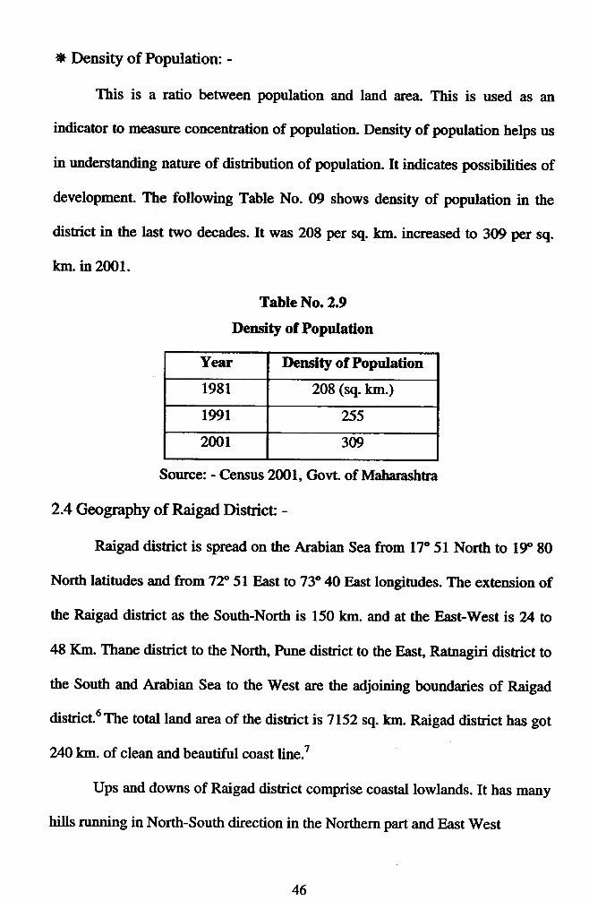
* Density of Population: -
This is a ratio between population and land area. This is used as an
indicator to measure concentration of population. Density of population helps us
in understanding nature of distribution of population. It indicates possibitities of
development. The following Table No. 09 shows density of population in the
district in the last two decades. It was 208 per sq. km. increased to 309 per sq.
km. in 2OOl.
Table No.2.9
Density of Population
Year Density of Population
1981 208 (sq. km.)
t99r 255
2001 3W
Source: - Census 2ml, Govt. of Maharashtra
2.4 Geognphy of Raigad Districf -
Raigad district is spread on the Arabian Sea from 17" 5l North to 19p 80
North latitudes and from 72" 5l East to 73" 4A East longitudes. The extension of
the Raigad district as the South-North is 150 km. and at the East-West is Vl to
48 Km. Thane dishict to the North, hrne district to the East, Ratnagiri district to
the South and Arabian Sea to the West are the adjoining boundaries of Raigad
district6 The total land area of the disrict is 7152 sq. km. Raigad district has got
2{Otllrn. of clean and beautiful coast line.7
Ups and downs of Raigad district comprise coastal lowlands. It has many
hills nrnning in North-South direction in the Northern part and East West
46
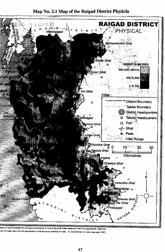
Map No. 2.1 Map of the Raigad District Physicla
6tcri ol lridiiliiinds into the soa to e digtmc. ot t*"tu"irutiiiFr?r m.asurod trom rho .pprop.i.t" oil-iivcY ot Indis mlp with th! rE.mis.ion of thc surylytr Grro,at ol lndi.. @ Governmmt ot Indir copyr€ht, a)01
47

No.2.2 of main Roads and
|w!t.'sof|ndi!rxlcnd5intoth€s9.toloictdciiurvay ot India mlp wirh thc parmis3ion of thc Survoyor Gcmral of India. @ Govcrnmcnt ol Indi, copyright.2ool
direction in the Southern part. The land slopes from Western ghat (Sahyadree)
towards the West up to the coastline. The river, valleys and coastal plains are
broader in the Norttrern part; short and swift rivers, narow valleys, drain lateritic
plateau.
Though Raigad is the name of the district, Alibag is the districts
headquarter. A dishict is divided into smaller administrative units called talukas.
They are Alibag, Murud, Shrivardhan, Karjaf Panvel, (lran, Pen, Khalapur, pali,
Rohe, Tale, Mangaon, Mtrasala Mahad and Poladpur.s
Jf knd Fonns: -
The different landforms in Raigad district constitute its physical set up. There
are three physical divisions: -
Area near the coast or low-lying area- the western part of the district lies
along the coastline. A major portion of the land is fertile and land near the sea is
non-fertile and sand mix.
1) The central low-lying fertile plain - Between the coastal area and the
mountainous region.
2) keacovered by the Satryadree Mountains.
tF Islands: -
Gharapuri (Elephanta), Khanderi-underi, Kasa, Kolaba and Janjira are
the islands in the district.
* Rivers: -
Most of the rivers in Raigad district have their soruce in the Sahyadree
Mountains to the east and flow westwards to meet the Arabian Sea. Raigad is
49

divided in to three parts north, middle and south. In the north four main rivers
are there lJlhas, Amba, Bhogawati and Patalganga. In the center Kundalika and
SaviEi in the south these are bigger rivers. Salt water from the sea has entered
the river mouths and so creeks have been formed.lo
tl Climate: -
Climate is one of the important factors, which directly and indirectly
affects the development of industry.
Raigad district is near the sea. The climate of the Raigad is moist and
generally healthy. Minimum temperature 16.1" c. and maximum temperaflue is
40.4" c. It rains heavily from June to September in the district. In fact it rains
heavily in the entire Sahyadree Mountains. The average annual rainfall is 2532
mm. In October-November rainfall occurs due to cyclonic storms.l2
Though the climate is hot and humid, it changes into humid from June to
September and from December to January it is cool and then it terns into hot.
May is the peah month of hot climate. Matheran is a hill station in the district.
In 1904, world famous magnetic observatory was established not only for
mehological study of Raigad but also for the India. The most important data in
Geophysics maintained here pertaining to past 115 years elevates its position to
few of its kind in the world. The system of its observation and experiments is
closely connected with the field of magnetism. The scientist all over the world is
extensively using the basic data in Geophysics collected here. Furnished with the
most modern equipments and apparahrs, it transmits intimation of the magnetic
storms to come, which absfract radio and telecommunication waves. From time
to time the observatory publishes its data incorporating its findings. It has a large
a)
b)
c)
demand from science students and scholars all over the world. The world famous
magnetic observatory is an ornament of Raigad district and an identity of the
district.r3
tF Agriculture: -
The economy of Raigad district is primarily agrarian in character. Near
about 50 percent of the population is engaged in agriculfire. Agriculture has
become the main occupation due to heavy rainfall.
Paddy is the main crop of the district.
Geographical Area - 6, 87,0fr) hector.
Forest Occupied Area - 1, 49,000 hector.
Crop Area - l, 7 4,WO hector.
Raigad is famous for rice (Basmati). Earlier Raigad was known as
'Granary of Rice' in the state. Even today Raigad produces 12 per cent of the
rice production of the state. Nachani, Jvari, Ragi is secondary; tur and val are
also grown in the area. Production of fruits like coconut, Areca nut, mango,
kokam, cashew nut, watermelon, chikkus, Jacltruit, guavas etc. are taken and
vegetables are also grown.la
Wells, lakes and rivers are the main sources of water supply. In some
places, using water from dams generates electricity. There are three powerhouses
at Bhira, Bhivpuri and khopoli in the district. There are the hydroelectric power
generation plants. Khopoli hydroelectric power generation plant was setup by
the Jamshedji Tata in 1910 to provide electricity to Bombay. The latest Uran gas
turbine power generation project was started in 1979.15
5t
Forest covers the 1/46 of the geographical area of the district. There are
quite few forests in the mountain areas of Pen, Panvel, Karjat, Rohe and
Srdhagad talukas. The main forest production is Tectona grandis, Mangitera"
Indica Terminalia, Arjuna seraca, Cassia Fistula, Santalum Album,
Azadirachta indica" fiscus, Rumphii, Bambusa, Arundinacea etc., nearly 1604.48
sq. km. Of land in Raigad is under cultivation. 2/+8 different tlpes of plants are
found in the district. Many of these scarce plants are used for medicinal and they
are found in the district only.tu
* Fishing: -
Fishing is the second largest occupation in Raigad district as 2l0O sq. km.
Seashore is available and near about 2000 different kinds of fishes are found in
the region. The share of Raigad dishict in fish prodrrction is 78 per cent of the
state. 103 villages are engaged in this occupation. There is abundant marine
wealth in the Arabian Sea. Fish is the most important of this marine wealth; fish
is the staple food of the people living in coastal area.
Surmai, bangda laid katri, rawas, saranga, pomphlet, pedve, renvya,
prawns and many qrpes of fish, shellfish and crabs are found in the sea. Prawns
are in great demand from other countries. According to the recent survey 61,058
fishermen are engaged in fishing. Annual marine production rose to 45,000
metric tones, in number of fish centers and fish production was Rs.47 crore.
Government provides subsidy to the fishermen to build boats. The total numbers
of co-operative societies are2,594 and the membership rose to 5,82,036.17
52
Thus agriculture, fishing and service sector are the main sources of live
hood. 65 percent of the totd population depends upon agriculture and allied
activities such as fishing.
tF Mineral wealth: -
Bauxite is found to some extent in the distict Shriwardhan, Rohe and
Murud talukas. Iron ore is also found at some places in the district.
Salc - There are many salpans in Uran, Pen and Panvel tatukas.
2.5 Religious and Cultural Raigad: -
There are hundreds of temples in the district. Kankeshwar, Mahad, Pali,
Udhar, Harihareshwar, Shivthar Ghal (the place at which saint Samartha Ramdas
wrote the holy book 'Dasbodh') are some of them. Ballaleshwar Ganpati temple
of Pali, and Varadvinayak of Mahad at Khalapur are two of the Ashtavinayak.
Religious minded people, Pilgnms and tourist visit these places in the Holi
month of Badrapad.
A newly estabtshed 'Birla Mandir' a beautiful temple of lord Krishna is
situated at hills Revdanda near Salav.
Harihareshwar is known as 'Dakshin Kashi' where the temple of lord
Shiva is situated. All religious minded people and tourist often visit the place.
Ganpati industry of pen is famous not only in India but also in the world.
The government and co-operative banks now support this industry. Ganpatis are
exported abroad from pen, which earn valuable foreign exchange. This industry
has provided large number of employment opportunities to the people.
53
2.6 Tourist Places in Raigad District -
Raigad district has been developing as one of the important tourist places
in the state of Maharashtra. A conducted tour is organized to see important
places in the district. There are extensive beaches and hilly scenic places with
good greenery in the district. However, toruism in konkan is not much
developed. Foreign tourists are not yet attracted due to poorly developed
hansport and due to lack of publicity of many known and unknown places.
As the konkan Railway already developed, it has become easier for
tourist to reach remote locations having beautiful scenery.
There is good potential to develop domestic tourism, as there are tourist
destinations of diversified nature.
o Forts: - Kulaba (Alibag), Avachitgad (Rohe), Karnala (Panvel), Padamdurg
(Janjira), Sarasgad (Pali), Raigad (Mahad), Lingana (Mahad), trGandori-Underi
(Alibag), Vishalgad (Chowk near Varsai) etc.
o Beaches: - Alibag, Varsoli, Sasawane, Revdanda, Nagaon, Akshi, Mandva,
Kihim, Munrd, Harihareshwar, Shriwardhan, Diveagar etc.
o Hill Station: - Matheran.
o Caves: - Elephanta Caves (Gharapuri 100 km. From Gateway Of India,
Mumbai), Tale, Kuda (mangaon), Thanale (Pali), Kondane (KarjaQ, aambivli
(Karjat), Gandharpale caves (Mahad), kol caves (Matrad), Khandsamble (Pali)
etc.
o Hot Spring: - Unhere (Pali). o Bird Sanctuary: - Karnala (Panvel). r8
54
2.7 Infodstnrchrre: -
The attraction of Raigad district is an industrial center stream from its
locational advantage. It takes four hours by road from Mumbai the capital city of
Maharashtra. Though the climate is moist it is generally healthy. Chemical,
engineering, iron product industries are predominant followed by consumer
goods industries.
Raigad district is under the jurisdiction of Collector of Raigad. Four sub-
divisions Alibag, Panvel, Mahad, and Mangaon were formed for adminishative
convenience. These sub'divisions are under control of Raigad.
r* Transporfi -
Transportation is one of the vital factors in the process of development of
industries. During the last two decades Raigad distict has received much
attention towards the developrnent of transportation and communication
facilities.
A district is just adjoining district to Mumbai and these are number of
industrial towns and urban centers well served with noad as well as railway
mnsport.
There are two national highways 1) Mumbai-Goa (NH.l7),2> Mumbai-
hrne-Bangalore (NH. 04) and one Mumbai-hrne Express highway passes
through the dishict. The present situation regarding the road length in Raigad is
given in the Table No. l0
55
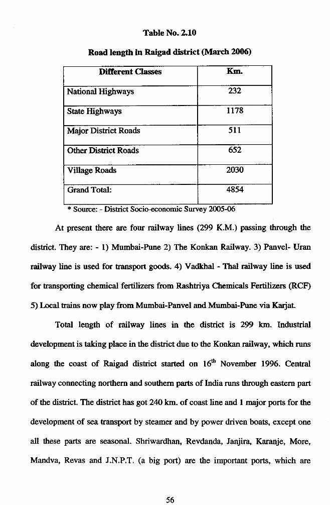
Table No.2.1.0
Road length in Raigad district (March 2006)
Difierent Classes Km.
National Highways 232
State Highways tt78
Major District Roads 511
Other District Roads 652
Village Roads 2030
Grand Total: 4854
* Source: - District Socio+conomic Survey 20O5-06
At present there are four railway lines (299 K.M.) passing through the
district. They are: - 1) Mumbai-hrne 2) The Konkan Railway. 3) Panvel- Uran
railway line is used for mnsport goods. 4) Vadkhal - Thal railway line is used
for transporting chemical fertilizers from Rashtriya Chemicals Fertilizers (RCF)
5) I-ocal trains now play from Mumbai-Panvel and Mumbai-hrne via Karjat
Total length of railway lines in the district is 299 km. Industrial
development is taking place in the district due to the Konkan railway, which runs
along the coast of Raigad district started on 16e November 1996. Central
railway connecting northern and southern parts of India nrns through eastern part
of thedistrict.Thedistricthasgot2401flrlof coastlineand I majorportsforthe
development of sea transport by steamer and by power driven boats, except one
all these parts are seasonal. Shriwardhan, Revdanda, Janjira, Karanje, More,
Mandva, Revas and J.N.P.T. (a big port) are the important ports, which are
56
service centers (traffic and cargo) for coastal shipping vessels that sail from
Mumbai southwards.
The coastal trade includes fish, mango, salt, sand, wood, foodgrains erc.
* Communication: -
The entire Raigad district is available on STD/ISD. Alibag GPO and
other talukas post offices offer public fax services. Speed post facilities are
available from GPO and talukas post offices. At present there are 438 post
offices and44 telegram offices.
Today 95.38 percent villages are connected with the telephones. The
telephone network is fastly expanding in the district. At present there are 20
Telephone exchange centers and l, 29,1& telephone holders. 66 per cent
exchange centers are directly interconnected with advanced equipments and
there is a direct fieling service to all over India. The first advanced C-DOT-
MAX (X4) electronic exchange center was set up at Alibag. Telex service is also
available in the district. There are lakhs of mobile holders. In the district Bharat
Sanchar Nigam has given 6491 Internet connections to the costomers. There are
21 Internetcafe in the district.
* Rlucational facilities: -
Raigad district is also well known for education. The renowned Raigad
Military School is at Lonere. There are two Central Schools, 2412 Pre-primary,
2,753 Primary, 282 Secondary, 74 Higher Secondary Schools, 7l Junior
colleges, 78 senior Collages, and 02 B.ed. Collage, 18 m, 03 Polytechnic
College, and 01 Technical University in the district. Various management
57

courses are conducted in the Senior Collage (D.B.M, D.C.M., B.C.S. etc.). These
courlses, degrees, and ITI provide an additional infrastruchrre to the growing
industrial district.
Raigad district has also to its credit an Ayurvedic (BAMS) Collage, 01
Government Polytechnic Collage, and Collage of Fngineering (03)
The first I-aw Collage was started under the stewardship of Advocate
D.N. Patil (Ex. MLA). Mahila Matravidyalaya (Pez.ari) atriliated to Mumbai
University is another feather in its cap. Yeshvantrao Chavan, SNDT, and Tilak
Maharashtra Open University are working as a noble mind for noble cause
through distance education in the district. As a result of increased educational
facilities the literacy rate has risen to77.32 per cent.
* Banking: -
There are297 branches of2O comrnercial banks and 101 branches ofco-
operative banks providing banking facilities to the people. Banking facility is
made available to 135 towns and villages. There are 05 branches of LIC and
2,8ffi Co-Operative Credit Societies in the district. The PCI of Raigad district at
current prices is Rs. 27,289.
{,.* Health Facilities: -
The medical facilities have also increased. In 2002, there were 16
hospitals, 12 dispensaries, 07 maternity hospitals, and 53 primary health centers
in the district. 221 doctors and 495 sisters were working in providing medical
facilities. 1005 beds were made available. Considering the vastness of the health
58
problem these facilities are meager.te In spite of these many more private
medical facilities are made available to the people.
tt Elechicity Supply: -
From 1947, Bhivpuri, Khopoli, and Bhira are three important electricity
generating units playing an important role to meet the increasing demand for
electricity. Over the past five decades there has been a massive increase in
installed electricity generating capacity in the district.
Similarly, irrigation facilities in the district have increased raising
irrigated area. In this regard Kal Project (Tal. Rohe), Amba valley medium
project (Tal. Rohe) and Hetawane medium project (Tal. Pen) have played an
important role and contributing in the historical development of district.
The need of electricity is met by the following power generation
companies, which have located their plants in different parts of the district. Thus,
due to these infrastnrctures, good climatic condition and convenient location
Raigad district has been selected as a growth center.
jf Adminishation: -
Raigad Trllah Parishad and 14 Panchayat Samitties were established on
l*t May 1961. At present there are 15 Panchayat Sarnitties, 1l Nagar Palikas,
818 Gram Panchayat Samitties, 1852 villages and 26 cities. Alibag is the capital
place. Collector office, Zl.llah Parishad, District Court and all-important
Government offices are at Alibag.e
59
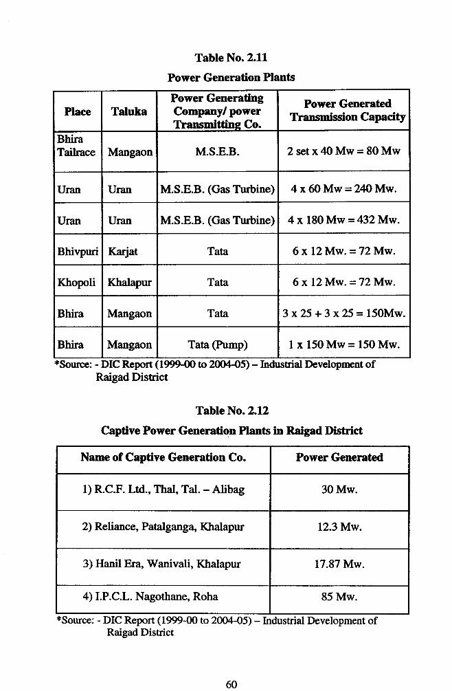
Table No. 2.11
Power Generation Plants
*Source: - DIC Report (1999-00 to 20(X45) - Industrial Dcvelopment ofRaigad District
Table No.2.1.2
Captive Power Generation Plants in Raigad Dishict
*Source: - DIC Report (1999-00 to 2004-05) - Industrial Development ofRaigad Dishict
Place TalukaPower GeneratingCompany/ IxlwerTransmittine Co.
Power GeneratcdTransmission Capacity
BhiraTailrace Mangaon M.S.E.B. 2setx4OMw=80Mw
Uran Uran M.S.E.B. (Gas Turbine) 4 x 6O Mw = ?.4OMw.
Uran Uran M.S.E.B. (Gas Tubine) 4 x 180 Mw = 432Mw.
Bhivpuri Karjat Tata 6x12 Mw. = 72Mw.
Ktropoli Khalapur Tata 6 x L2 Mw. = 72Mw.
Bhira Mangaon Tata 3 x25 + 3 x 25 = l50Mw.
Bhira Mangaon Tata (Ptmp) I x 150 Mw = 150 Mw.
Nane of Captive Generation Co. Power Generated
1) R.C.F. Ltd., Thal, Tal. - Alibag 30 Mw.
2) Reliance, Patalgang4 Khalapur 12.3 Mw.
3) Hanil Era' Wanivali, Khalapur 17.87 Mw.
4) I.P.C.L. Nagothans Roha 85 Mw.
60
2.8 Industrial Raigad Districfi - (Alibag District Headquarter)
After 1960, Maharashha Industrial Development Corporation occupied
vast area consisting of 893 hectors of land at Taloja for industrial development
in pursuance of its industrial dispersal (location) policy announced n 1962.
Further, impetus to industrial growth of Raigad district was received
when other industrial estates and colonies were established to develop Raigad
district as growth center.
Thus, Raigad district appeared on the industrial map of Maharashtra,
especially after 1960. We will discuss now about the industrial growth of Raigad
district.
* Raigad District as an Industrial Center at a Glance
o Location: - 100 to 200 km. by road from Mumbai.
o Total land area: - 7,152 sq. km.
o MIDC areas: - 3935-$8 hec{ors.
1) Rohe (1963) -24.59 hectors
2) Patalganga & additional Patalganga (Khalapu) QnD - 316.762 hectors.
3) Taloja (1968) -823.35 hectors
4) Mahad and additional Mahad (1980) -925.49 hectors.
5) Nagothane - 622.25 hectors
6) Usar -238.N hectors
7) Vilebhagad - 7&.16 hector
o Co-Operative Industrial Estates: -
1) Panvel Co-Operative Industrial Estate, Panvel (1963) - 12.31hectors
61
2) Javatrar Co-Operative Industrial Estate, Kamothe, Tal- Panvel (1965) - 23.8
hector.
3) Khopoli Co'Operative Industrial Estate, Khopoli, Tal- Khalapur (196l.) -10.9 hectors.
4) Adarsha Ce'Operative Industrial Estate, Alulwadi, Tal- Panvel, Plots-130
5) Sahyadri Co-operative Industrial Estate. Nanore TaL - Mangaon (Proposed)
Plots-99.
In addition to these, following industrial estates have been established in
the kivate Sector.
1) Alibag Co-operative Industrial Estate, Kurul, Tal- Alibag.
2) Universal Industrial Estate, Dheku, Tal - Khalapur.
3) Arcose Industrial Estate, Dheku, Tal - Khalapur.
4) Kedia Industrial Development Corporation, Dhelu, Tal- Khalapur.
5) Anrold Industrial Estate, Dheku, Tal - Khalapur.
These industrial areas are on the Mumbai-Goa and Mumbai-hrne
national highways and close to Mumbai.
Investment made in the above areas is leading in comparison to the
invesfinent made in the Maharashtra State.
* Number of small-scale industries - 1,186
* Total capital investment - Rs. 495.28 crore
* Direct employnent in permanent SSIs - 15989
* Proposed SSIs, investment and expected emplo5rment: -
o Numberof SSIs -2,741
62

o Capital investment - Rs.l, ll,595l- Laktl
o Employment generation -31,514
* Medium and large-scale industries - 228
* Total capital invested-Rs. 28638.63 Crore.
* Direct employment generated -21417
In addition to these, the government has issued 1105 licenses to 127 new
proposed medium and large-scale industries.
o Proposed capital investment - Rs.46, 165 Crore.
. Expected employrnent generation - 1,33,536
The Government of Matrarashtra has approved 111 Foreign Direct
Investment Proposal with an expected Foreign Direct Invesftnent of Rs. 3392.63
Crore (as on 31.10.2m6)*
2.9Indusffial Growth of Ralgad District
It Period before 196,0 -Raigad district was well known for handicrafts, village and cottage
industries since the medieval and Maratha perid. Being near to sea salt
manufacturing was the main business. Alibag, Pen, Rohe, LJran and Karjat these
were the centers. Shivaji Maharaja had started a ship building industry. Further,
encouragement to this industry was given by the kanhojee Angre.
Since, the period of Mugal and Portuguese Chauls handloom silk industry was
prosperous. In 1871, an Ayurvedic medicine factory was started at panvel. In
between 1871 and 1881 about 20 distilleries were started at Uran. In 1887. the
* DIC Report 2Wl-2006. Raigad.
63

first machine Rice mill was started at Panvel. In 1911, Bidi factory was started at
Mahad. In 1915, 1922 and 1927 l(hopoli, Bhivptri and Bhira these three hydro
electricity generating units were started by Tata to meet the electricity demand in
Bombay. Two paper-manufacturing units were started at Khopoli and Apta. The
foundation of engineering industry was laid in 191O with the establishment of
Griendwel Ambresives at More Uran. This industry was started with the help of
Czechoslovakian technicians. A small cutlery factory was started at Pen.
During 1947-19ffi significant industries were established in the district.
Paper and paper products industries were started at Khopoli. In 1954, a pioneer
concern manufacturing pharmaceuticals such as Sodium, Salicylate, Salicytic
Acid, and Aspirin was started at Khopoli. Rice mill and poha mills were
established in the Raigad. ln 1957 one small-scale unit manufacturing adhesive
tapes was started at Khopoli. As a result of increase in urban population a few
printing press were started in the district. Four small-scale factories
chemicals, drugs were started in Raigad district.
The industrial development of the district was started since the I$and trd
World War. But it is also tnre that during this period with the rise of factory
industries, the handicrafts and cottage indusfries started to decline.
After independence new types of small, medium, and large-scale
industries came in to existence in the district.2o
* Growth after 1960 -
Raigad district remained neglected so far as industrialization
concerned up to 1960. Most of the industrial growth in Maharashtra
&

centered in Bombay, Pune, and Thane-Belapur belt. Over a period of time this
belt got safiuated and industries started growing in the neighboring district
Raigad.
After 1960, several factors gave impetus for the development of
industries in the district. Government policy regarding dispenal of industries,
development of roads and railway network, development of power station,
industrial areas and industrial estates etc. Due to dispersal policy adopted by the
Government, most of the industrialists selected sites like Taloja, Panvel,
Patalgang4 Rohe, Mahad and Khopoli for their industries. Growth of industries
got impetus in the district since ln}, due to various incentives provided by the
govenunent to the chemical and engineering industries out of Bombay.
Backward area development programme, incentives and package scheme,
area developed by MIDC, two national highways, incentives offered by Konkan
Development Corporation, vicinity of Mumbai market etc. are responsible o
accelerate the pace of indushial development.
It was then, that Raigad was selected as an industrial center. As a result
the highest investment in public sector industries is made in this district.
The government was created the atmosphere of industrialization in the
district with the establishment of Hindustan Organic Chemicals at Rasalni near
Panvel. Chemical fertilizers and Petrochemical industries in the public sector
and chemical and engineering industries in the private sector were started, due to
priority glven by the goveflrment to chemical and petrochemical companies in
the district. In 1984 there were 4 big public sector and 31 private sector
65
industries. According to study done by CIME (1985), there were 35 big
industries in the district in 1984 and their total sale was Rs. 802.M crore. Of this
amount the share of private sector was Rs.741.64 crore. In 1989-90 there were
168 companies wittr an investment of Rs.236746.O9 lakh. Unprecedented
industrialization took place in l(hopoli, Taloja, Panvel, Patalganga, Roha,
Nagothane, Rasayani, Maha{ Thal-Vayshet, Dhatav and Usar area. In these
anreiari, basic chemicals, chemical things, pehochemicals, chemical fertilizers,
insecticides, medicines, colors (dyes), Polyester and other fiber, plastic goods,
iron products, machineries, which are used in other companies and consumer
products etc., are produced. In these places numbers of large, medium, and small
industries are started and numbers of new big industries are taking place. One of
the largest steel markets in India is estabtshed at Kalamboli (Tal - Panvel).
The public and private enterprises have played an important role in the
industrial development of the district and has errerged as a developing disnict in
the state. The important Public and Private Sector Industries in the district are as
follows.2l
The hftlic Sector Indushies: -
l) Rashtriya Chemicals and Fertilizers Ltd. Thal, Alibag
2) Oil and Natural Gas Corporation, IJran.
3) Indian Petrochemicals Ltd., Nagothane.
4) Hindustan Organic Chemicals Ltd., Rasayni.
5) Jawaharlal Nehru Port Trust, Nhava-sheva Port, Uran.
66

6) Matrarashtra Agricultural and Industrial Development Corporation,
Rasa5mi, Panvel.
7\ Hindustan Industries Ltd., Rasayni Tal- Panvel.
8) Gas Thrbine Project of Maharashha State Electricity Board, Uran
9) Hindustan Peholeum Corporation, fJsar Tal- Alibag.
10) Gas Authority of India Ltd., Usar.
In addition to these there are following Mega hojects in the hivate Sector.
1) Reliancelndustries,Patalganga.
2) Vikram Ispat Ltd., Salav.
3) E Merck India Ltd.
4) Float glass Ltd.
5) Nippon Denro Ispat Ltd., Dolvi, Pen.
6) Tata Hydroelectric Power Supply Company Ltd., Khopoli, Bhivpuri, Bhira.
7) Konkan Spthetic Ltd.
8) Supreme Petnochemicals Ltd.
9) Maharashtra Climes Company Ltd.
10) Hindalco Industries Ltd.
1l) Nirlon Ltd.
12) Trimbak Steel Ltd.
13) Bhushan St€el Ltd.
14) Uttam Galva Steel Ltd.
These projects have contributed a lot in the industrial development of the
district. Raigad is suitable for industrial development for the following rquons: -
67

l) It has a convenient location being equi-distant from Mumbai and hrne.
2') It is blessed with favorable climatic conditions, which are essential for the
development of chemical and engineering industries.
3) Raigad district is well linked by a network of roads and rail routes. It is
situated on north-south main line of central railway malcing it convenient to
reach the northern and southern part of the country. Two major national
highways viz; Mumbai-Rrne-Bangalore (N.H. 04) and Mumbai-Goa (N.H.
17) and one Mumbai-Pune express highway. It is 10G20 km. away from
Mumbai and is well connected by road and rail.
4) Easy availability of manpower.
5) Ports in the dishict provide cheap water transport facility to send goods in the
Mumbai market as well as to export goods abroad etc.
Due to these locational advantages Raigad distict appeared on the
industrial map of Maharashha only after 1970. Things started changing for the
better after ln0.
2.10 hofile of Raigad Industrial Areas.
1) Panvel Co-operative Industrial Estate, Panvel.
o l-ocation - Located on Bombay- Rrne road, about 70 km. from Mumbai and
60 km. from district headquarter, (Alibag).
o Establishment - 1963.
o Total Land Area - 12.13 hector
o Total Plots - 103
o Type of industries- 1) Chemical2) Engineering 3) Pharmaceutical
68
2) Khopoli Co -operative Industrial Estate, Kholnli, Tal. Panvel.
o Location - Located on Mumbai-hrne road about 100 km. from Mumbai and
60 km. from district headquarter, Alibag.
o Establishment - March t6,l9&
o Total knd Area- 10.9 hectors.
o Total plots - 80
o Type of industries - 1) Engineering 2) Ctremical 3) Plastic & 4) Paper.
3) Jawahar Co -Operadve Indusdal Estate, Kamothe, Tal. tr(halapur.
o Location - L,ocated on Mumbai-hrne road about 85 km. from Mumbai and
45 km. from disEictheadquarter, Alibag.
o Establishment - 1965
o Total I-and Area - 23.8 hectors.
o Total plots - 245
o Type of industries - 1) Chemical2) Engineering 3) Pharmaceutical & Paper.
4) Roha industrial Estate, Roha"
o Location - Located nearby Mumbai-Goa road about 60 km. from district
Headquarter.
o Establishment- 1963
o Total I-and Area- 2M.59 hectors.
o Total plots - 113
o Type of industries - 1) Chemical 2) Electrical 3) Consumer goods
5) Taloja industrial Estate, Taloja Tal. Panvel.
69
o Location - Located on Mumbai-hrne road about 60 km. from Mumbai and
40 Km. from disrict headquarters, Alibag.
o Establishment- 1968
o Total Land Area- 832.35 hectors.
o Total plots - 891
o Type of industries - 1) Chemical2) Pharmaceutical3) Engineering etc.
6) Patalganga IndusHat Estatc, Patalganga, Td. Panvel.
o Location - Located on Mumbai-Goa road about 70 km. from Mumbai and 40
km. from district headquarters, Alibag.
o Establishment - 1979
o Total Land Area - 313.70 hectors.
o Total plots - 69
o Type of industries - 1) Chemical2) Pharmaceutical 3) Paper etc.
7) Mahad Industrial Estate, Mahad, Tal. Mahad.
o Location - Located on Mumbai-Goa road about 190 km. from Mumbai and
90 km. from district headquarters, Alibag.
o Establishment - 1980
o Total Land Area- 925.49 hectors.
o Total plots - 284
o Type of industries -l) Chemical 2) Plastic 3) Pharmaceutical and Consumer
goods etc.
70

2.11 Concluding Comments: -
Thus, it is apparent that the socio-economic and industrial development of
the district is depended on the number of factors like geographical, historical,
social and economic (factors- environment, worlf,orce, infrastnrcture,
goyernment policy etc.). This has especially resulted in the growth of chemical,
iron and engineering industries. The climatic condition and vicinity of the capital
place Mumbai have helped for the rapid growth and developrnent of small
medium and large-scale industries and the district thus fastly emerged on the
industrial map of the country especially after 1990.
____-rr_--__
7l

References: -
1. s.M. Deshmukh, Asa Ha Raigad, Sudhanshu hakashan, Alibag, 2003,p.7-
8.
2. Government of Matrarashtra" Matrarashha State Gaz.etteer, Raigad district,
1993, P.1
3. S.M. Deshmukh, qrcit, p.2l-23.
4. Suhas Kulkarni, Mlind charrpamerka, (Ed), Dhadval satrashak, Roshan
Prakashan, Rme, 2W3, p.Z0l.
5. S.M. Deshmukh, opcit, p.23.
6. Government of Maharashtra, O1rcit, p.2.
7. Government of Matrarashtra, District Socio-Economic Survey, District
Directorate of Economics and Statistics, Mumbai, 2OO2-03,p.2-3.
8. Ibid, p.3
9. DIC, 'Report on Industrial Development of Raigad District, 1999-200O to
2W-05,, Alibag, p.3.
10. Director, Matrarashtra State Bureau of Textbook Production and
Curriculum Research, hrne, General Geography, 20[1, p.62-63.
I l. DIC Report, Opcit, p.l6l7.
12. Government of Matrarashtra Opcit, p.l6-17.
13. DIC Report, Opcit, p.3.
14. D.G. Gatade, Industrial Geography of India, Print well Publisher, Jaipur,
1986, p.25.
15. Government of Maharashtra, Opcit, p.l9-45.
72

16. S.M. Deshmulfi, Opcit, p.l2-27.
17. Ibid, p.36-95.
18. Government of Maharashtra, Dishict Socio-Economic Survey, district
Directorate of Economics and Statistics, Mumbai, 2W2-O3,p.12+.155
19. Government of Maharashtr4 Opcit, p.319.
20. Ibid, p.320404.
21. DIC Annual Report, Alibag,2005-06.
73
![ftYgk %& jk;xM lu 2000 fiMhr - Raigad Policeraigadpolice.gov.in/pdfdocs/Raigad District Atrocity Info. of the... · ftYgk %& jk;xM lu 2000 vuqlwfpr tkrh] vuqlwfpr tekrh o ukxjh gDd](https://img.pdfslide.us/doc/110x75/5c7abe6009d3f264308b598b/ftygk-jkxm-lu-2000-fimhr-raigad-district-atrocity-info-of-the-ftygk.jpg)