Embed Size (px)
Citation preview
Available online at www.worldscientificnews.com
( Received 29 January 2018; Accepted 15 February 2018; Date of Publication 16 February 2018 )
WSN 94(2) (2018) 217-235 EISSN 2392-2192
Spatial Distribution of Government and Donor Organization Provided Public Water Facilities in Uyo
Metropolis, Niger Delta Region, Nigeria, Using Geographical Information System
Sunday Edet Etuk1, Okechukwu Ebuka2,* and Ekaete Sunday Edet3
1Department of Physics, University of Uyo, Uyo, Nigeria
2Department of Physics, Michael Okpara University of Agriculture, Umudike, Nigeria
3Department of Geography, University of Lagos, Lagos, Nigeria
*E-mail address: [email protected]
ABSTRACT
Crisis of water scarcity, pollution and pricing is universal and of international concern. Its
consequence is worse than that of terrorism, war, nuclear and chemical weapons. Withdrawal or
pollution of all water sources can cause death of all mankind, plants, living things and the ecosystem
at large. Influenced by the above and the fact that availability of potable water sources, adequately
distributed is a requirement for development, the authors conducted research to evaluate spatial
distribution of public water facilities in Uyo metropolis in the Niger Delta Region of Nigeria. Primary
data obtained through direct exploratory survey of public water facilities within Uyo metropolis and
their respective geographical locations using GIS (Geographical Information System). Result indicate
that public water facilities located within Uyo metropolis are not evenly and adequately distributed,
hence scarcity in public water supply, causing the inhabitants to depend mainly on untreated private
borehole water. This does not guarantee healthy living, thus, a negation of achievement of Millennium
Development Goals (MDGs).
Keywords: Borehole Water, Groundwater, Public Water Supply, Spatial Distribution, Uyo Metropolis
World Scientific News 94(2) (2018) 217-235
-218-
1. INTRODUCTION
Water is basically indispensable natural resources, most necessary requirement of life
after air According to Adedeji et al (2010), George et al (2014) and Molden et al (2001a),
availability of reliable source of water is an essential requirement for sustainable
development. It is one of the world development indicators. Water has no known substitute in
many of its numerous uses. Portable water is one that is safe to drink, pleasant to taste and
very un-objective and colorless (Nigerian Standard for drinking water quality 2007). Water
usage transcend domestic to agriculture, industrial, maintenance of ecosystem, hydro-electric
energy generation among others (Jiya and Bakare 2002; Smaktin 2002; Oweis and Hachum
2001; Rosegrant et al 2002; Oweis et al 1999; Johnson et al 2001; Gracia et al 2001; Molden,
1997, Molden et al 2001b; FAO 1996; Etuk et al, 2016a; Etuk et al, 2016b). The above
notwithstanding, increased demand for urbanization affects natural water resources
(McMahon, 2010).
Urbanization leads to depletion of natural resources, such as deforestation, drying or
destruction and pollution of surface water as well as contamination of ground water. Moreso
underground water aquifer are drained at a rate faster than the water can be recharged, hence
depletes groundwater (Hinrichsen et al, 1998; Garg and Garg, 2008; Rosegrant, 2002), as a
result of overpopulation and expanded utilization of fresh water (Garg and Garg, 2008; Gleick
1998; Gleick 1999; Gleick et al, 2000; Gleick et al 2002; Resegrant, 2002; Molden et al
2001a). Thompson and Hickey (1996) posit that a major urban area that includes a large
central city surrounded by several smaller incorporated cities and suburbs that join to form
one large recognizable municipality is termed metropolis.
Uyo, the state capital of Akwa Ibom State within the Niger Delta region of Nigeria, falls
within the description of a metropolis. This research on spatial distribution of public water
facilities provided by Government and donor agencies in Uyo metropolis, becomes necessary
because of the metropolitan nature of Uyo and the associated potable water problems.
Justification of this study is in the fact that the extent of urbanization of Uyo as a state capital,
considering its metropolitan status has led to increasing population and depletion of natural
water resources, such as stream, lake, spring coupled with pollution of water aquifer and rain
water (Ekong et al 2012, Agbasi and Etuk 2016), which the inhabitants have hitherto been
relying on. Municipal source comprising: leakages from liquid waste and solid waste from
land fill, kitchen waste, waste from trading activities and sewage; Industrial source including
pipeline leakages, oil fields and brines, liquid waste tank, gas flaring and fumes from exhaust
pipe; agricultural sources consisting of irrigation return flow, animal droppings, fish pond
waste water, fishing chemical and fertilizer are some of the causes of this water problem. This
gives rise to scarcity of fresh water, hence, subsequent demand for alternative sources of
water such as hand dug wells and boreholes, as well as water from government and donor
agencies’ water facilities, which is often considered as treated water. The report of this study
plausibly will assist in achieving Vision 2020 as well as Water and Food 2025.
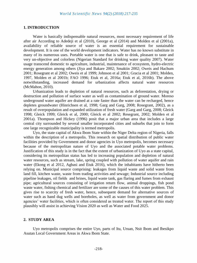
2. STUDY AREA
Uyo metropolis comprises the entire Uyo, parts of Itu, Uruan, Nsit Ibom and Ibesikpo
Asutan Local Government Areas in Akwa Ibom State.
World Scientific News 94(2) (2018) 217-235
-219-
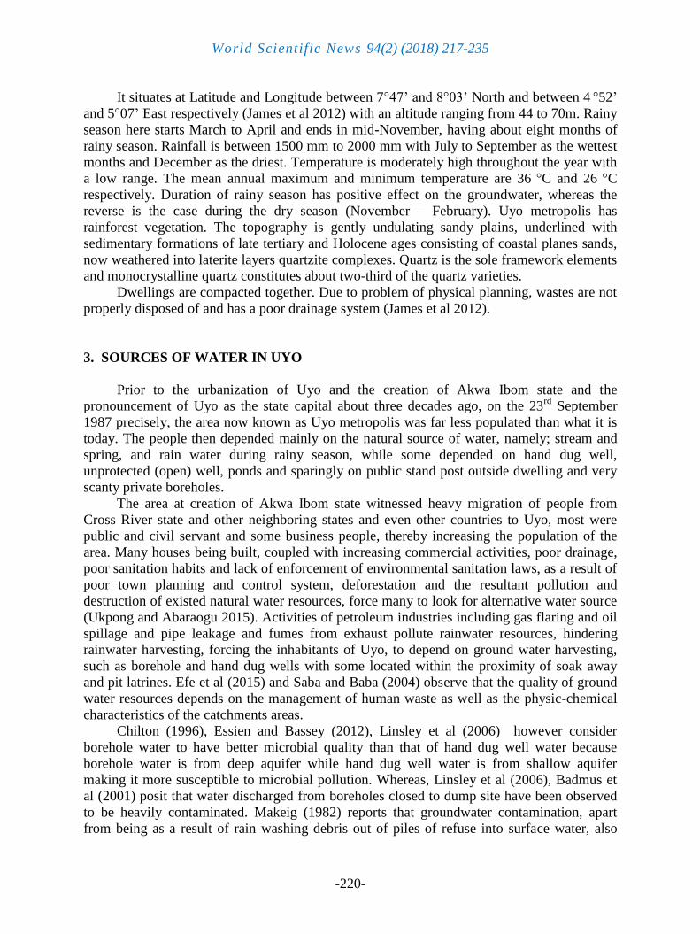
Figure 1. Map of Uyo Metropolis
World Scientific News 94(2) (2018) 217-235
-220-
It situates at Latitude and Longitude between 7°47’ and 8°03’ North and between 4 °52’
and 5°07’ East respectively (James et al 2012) with an altitude ranging from 44 to 70m. Rainy
season here starts March to April and ends in mid-November, having about eight months of
rainy season. Rainfall is between 1500 mm to 2000 mm with July to September as the wettest
months and December as the driest. Temperature is moderately high throughout the year with
a low range. The mean annual maximum and minimum temperature are 36 °C and 26
°C
respectively. Duration of rainy season has positive effect on the groundwater, whereas the
reverse is the case during the dry season (November – February). Uyo metropolis has
rainforest vegetation. The topography is gently undulating sandy plains, underlined with
sedimentary formations of late tertiary and Holocene ages consisting of coastal planes sands,
now weathered into laterite layers quartzite complexes. Quartz is the sole framework elements
and monocrystalline quartz constitutes about two-third of the quartz varieties.
Dwellings are compacted together. Due to problem of physical planning, wastes are not
properly disposed of and has a poor drainage system (James et al 2012).
3. SOURCES OF WATER IN UYO
Prior to the urbanization of Uyo and the creation of Akwa Ibom state and the
pronouncement of Uyo as the state capital about three decades ago, on the 23rd
September
1987 precisely, the area now known as Uyo metropolis was far less populated than what it is
today. The people then depended mainly on the natural source of water, namely; stream and
spring, and rain water during rainy season, while some depended on hand dug well,
unprotected (open) well, ponds and sparingly on public stand post outside dwelling and very
scanty private boreholes.
The area at creation of Akwa Ibom state witnessed heavy migration of people from
Cross River state and other neighboring states and even other countries to Uyo, most were
public and civil servant and some business people, thereby increasing the population of the
area. Many houses being built, coupled with increasing commercial activities, poor drainage,
poor sanitation habits and lack of enforcement of environmental sanitation laws, as a result of
poor town planning and control system, deforestation and the resultant pollution and
destruction of existed natural water resources, force many to look for alternative water source
(Ukpong and Abaraogu 2015). Activities of petroleum industries including gas flaring and oil
spillage and pipe leakage and fumes from exhaust pollute rainwater resources, hindering
rainwater harvesting, forcing the inhabitants of Uyo, to depend on ground water harvesting,
such as borehole and hand dug wells with some located within the proximity of soak away
and pit latrines. Efe et al (2015) and Saba and Baba (2004) observe that the quality of ground
water resources depends on the management of human waste as well as the physic-chemical
characteristics of the catchments areas.
Chilton (1996), Essien and Bassey (2012), Linsley et al (2006) however consider
borehole water to have better microbial quality than that of hand dug well water because
borehole water is from deep aquifer while hand dug well water is from shallow aquifer
making it more susceptible to microbial pollution. Whereas, Linsley et al (2006), Badmus et
al (2001) posit that water discharged from boreholes closed to dump site have been observed
to be heavily contaminated. Makeig (1982) reports that groundwater contamination, apart
from being as a result of rain washing debris out of piles of refuse into surface water, also
World Scientific News 94(2) (2018) 217-235
-221-
occur due to contamination potential of leachate from the waste. This is in support of
Schneider (1970) which, has it that leachates from open dumps and sanitary landfill normally
contain both chemical and biological constituents, and is also supported by Lawal et al 2013.
This is plausibly due to the fact that water level values for Uyo metropolis ranges between 40
and 55m. It is within a coastal plain sands (Akpabio and Ekanem, 2009). This is in agreement
with the report of Laouini et al (2017).
Water is observed to get easily contaminated if not well treated and adequate protection
given to its flowing channels. Essien and Bassey (2012) list sources of water pollution to
include insanitary condition during borehole construction, flooding of runoff into boreholes to
septic tanks, injection of hazardous waste into the underground geologic formation. Hart and
White (2006) has it that absorbed toxins in rainwater percolating through garbage in landfill
contaminate water to a shallower depth of about 33m when it infiltrates into the soil.
Pollutants of storm runoff sinking into the soil pollutes underground water located at a
shadow depth (McMahon 2010). Elshazly and Konsowa (2003) observe that one of the most
water polluting industries is the metal finishing industry due to the heavy metal ions content.
3. 1. Problem Statement
Uyo metropolis with massive population and heavy population density, with depleted
natural water resources, crowded housing, poor sanitary habit and policy and poor drainage
system is bound to have contaminated water from hand dug water wells and untreated private
boreholes, whereas water from government provided public water facilities, government
agencies and International water donor agencies is always located away from sewage and
other sources of contaminants. This is because government unlike private individuals is
capable of acquiring land for locating of water source far away from residential estates and
industrial areas for good water quality and can take care of the cost required for proper
treatment of water for healthy living. This research is our response to the shared interest of the
International Food Policy Research Institute (IFFRI) and International Water Management
Institute (IWMI) on water and food security in the 21st century.
4. MATERIALS AND METHOD
4 .1. Materials
Global Positioning System meter (GPS): was used to record the geographical locations
where public water facilities provided by government and donor agencies are located in Uyo
metropolis. A tricycle was also employed to enhance movement from street to street for the
purpose of the survey and taking of statistics of such water facilities.
4. 2. Methods of Data Collection
Movement from street to street within Uyo metropolis was embarked upon to locate and
identify all the Public water facilities provided by government at all level, government
agencies and International non-government donor agencies. Direct counting by tally and
record method was employed. The Latitude, Longitude and Altitude of each location of the
public water facilities were read using the GPS and recorded for the location of the facility,
coupled with a face to face interview with residents living or doing business very close to the
location of the facilities to know the functional and the nonfunctional facility.
World Scientific News 94(2) (2018) 217-235
-222-
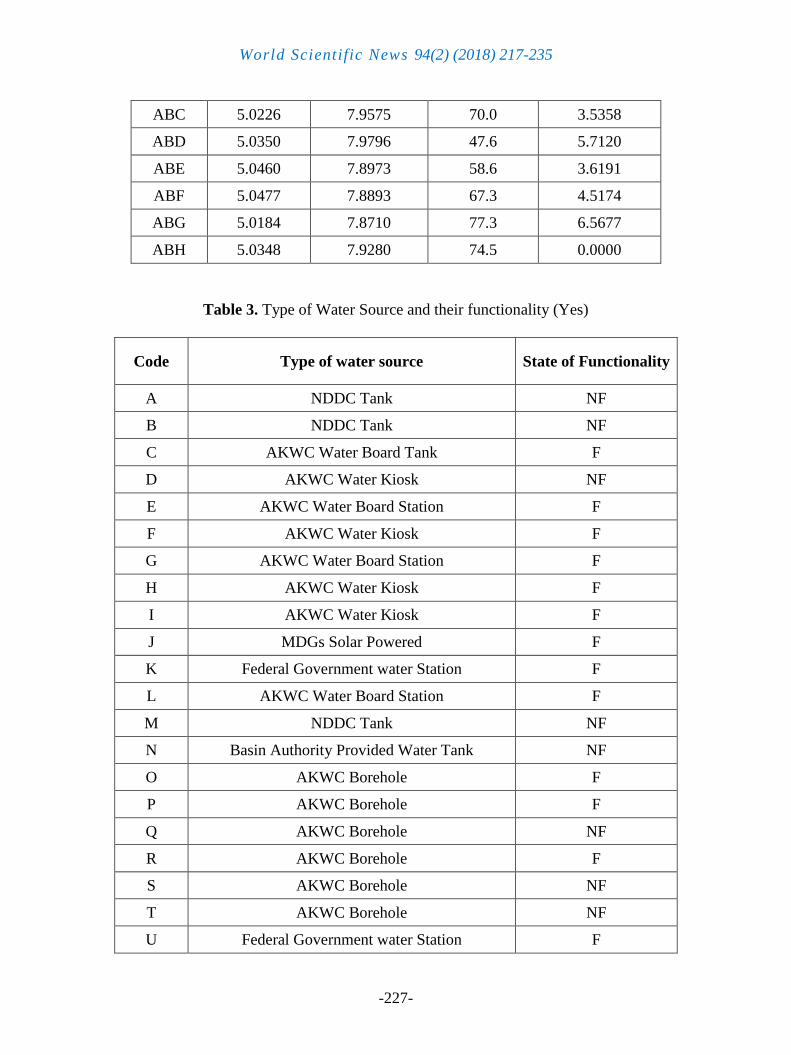
5. RESULT AND ANALYSIS
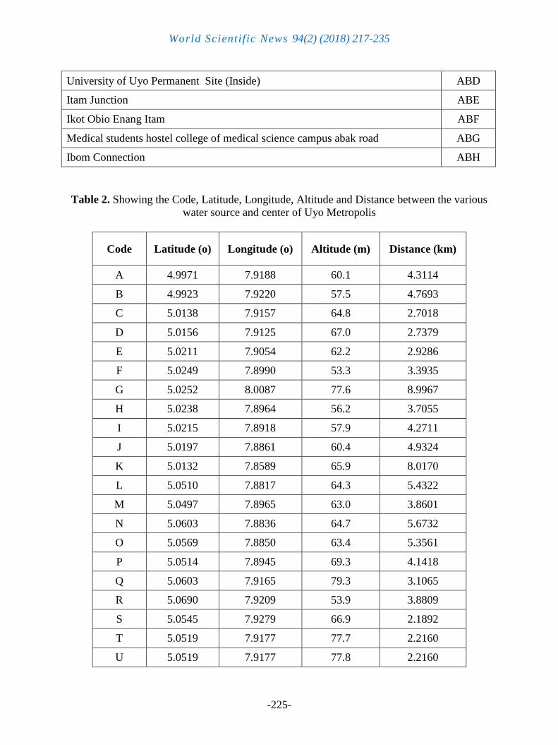
The data collected was purely primary data. Table 1 is the table showing the location
and code names of the locations, while table 2 shows code, latitude, longitude, altitude in
meters and distance in Kilometers, from the reference point (Ibom Connection) to each of the
public water source within the study area. Table 3 shows the type of public water facilities
provided by government and donor agencies in Uyo metropolis. Table 3 shows that there are
six main state water major water pumping stations and water distribution reservoir facilities
operated by Akwa Ibom Water Company at Ekpenyoung street/Paul Bassey street, Itam/Ikot
Ekpene road, Akwa Ibom state secretariat Abak road/Babangida Avenue, Idu/Nwaniba Road,
Ifa/Oron Road, and behind Ibom International Stadium. Two other sub stations are located at
Ewet Housing Estate and Shelter Afrique. Water Kiosk having four (4) taps each serving as
public water stand post located at the locations geographically described in table 2. The result
of face-to-face interview with the residents of the study areas revealed that 81.82% of the
water kiosk stations are functional, while 18.18% are not functional. The survey equally
shows 37 number of water projects with borehole, water tank and stand with water pump,
some of which are tagged solar power operated designated Niger Delta Development
Commission (NDDC) water project. The result of oral face-to-face interview with the
residents reveals that Niger Delta Development Commission (NDDC) sponsored water
projects often becomes nonfunctional soon after commissioning. It was gathered that in most
cases the water pumps go bad in less than three (3) months, as a result of inferior quality of
pumps installed by Niger Delta Development Commission (NDDC), whereas some are
immediately removed by thieves’ consequence upon lack of community participation, hence,
lack of adequate and functional security.
Other public water facilities provided are found at public institutions premises such as
University of Uyo which has three (3) mini pumping stations, one (1) per campus and one (1)
at the University of Uyo Teaching Hospital. The Community Based Urban Development
Project, World Bank sponsored water project are seen at Ikot Udoro and Akpan Essien Street.
The response of residents within the vicinity where they are located reveals that none has ever
functioned since the facilities were installed.
92% of the respondents of structured face-to-face questionnaire indicates that majority
of the population of Uyo metropolis depend on private borehole water for their water. This is
so because flow of water from the public stand point water taps that are even considered
functional is irregular, very sparing and epileptic, the situation 13% of the face-to-face
interviewed respondents say is synonymous to the electricity power supply situation in the
state, since water pumping depends on availability of electricity, whereas 38% attribute it to
nonchalant attitude of those responsible to government own facilities, while 49% associate the
situation to corruption on the parts of the operators and managers of the project. 4% of the
respondents claim to depend on stream water for their daily water supply. The 4% are from
extreme end of Nwaniba, Uruan, Nsit Ibom, Itam and Ibesikpo, Asutan part of Uyo
metropolis.
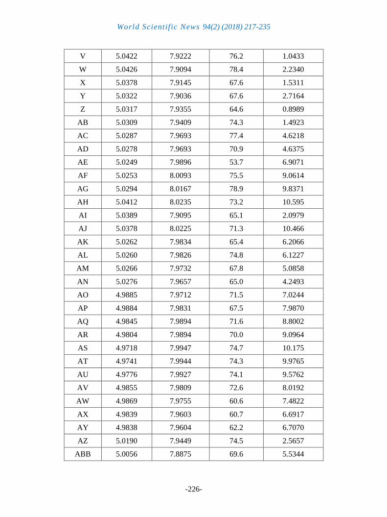
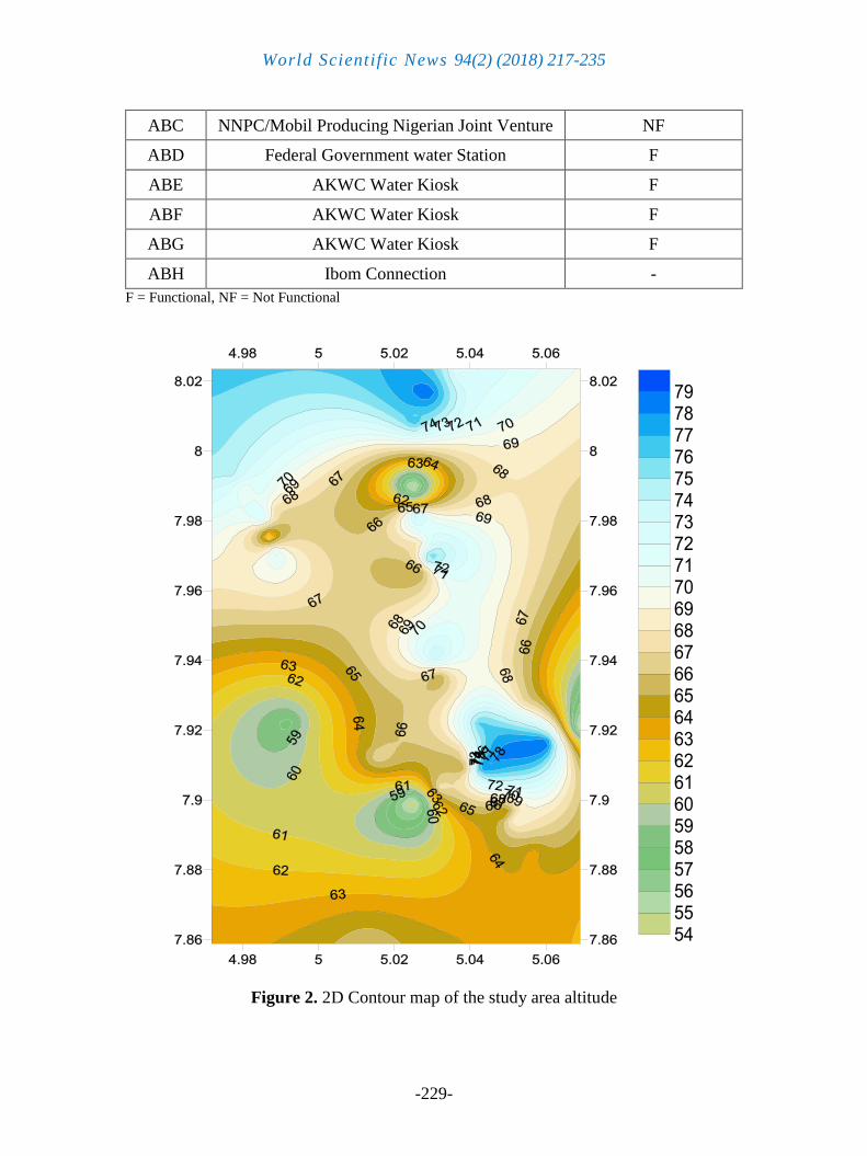
Judging from Figure 2, It can be seen from the 2D contour showing altitude of the study
area that the lowest altitude is 47.6m (University of Uyo, permanent site), while the highest
Altitude is 79.3 m (community secondary school, Ibiaku Itam, Urua Ekpa, Calaber Itu
Expressway). The closet distance from the reference point (Ibom Connection) to a water
source is 0.8989km at Ekpenyong Street, while the longest distance between the references
World Scientific News 94(2) (2018) 217-235
-223-
points (Ibom connection) and a water source is 10.5953 km at Nwaniba Road, point 6. The
longest distance between two Public water sources is 14.387 km (Mbak Itam 3 to Akwa Ibom
Water Company limited, Idu head works). While the shortest distance between two public
water sources is 0.4068 km (IBB to Aka Akapube street motherless Babies center). 95.32 km2
is the total square meter of the study location as compared to the total square meter of Akwa
Ibom state which is 7081 km2. The public water sources are not evenly distributed with
respect to the altitude of the study area.
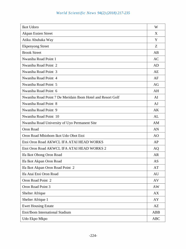
Table 1. Location and Code Name for the Study Area
Location Code
Nung Oku A
Nung Oku Point 2 B
Aka Akpaibe Street motherless Babies’ Center C
IBB D
AK state secretariat Akwa Ibom water company Limited state secretariat HQ Uyo E
Abak opposite mechanic village F
Akwa Ibom water company limited Idu Head works G
Abak road opposite Government secondary school Afaha offot H
Abak road I
Abak Road, Primary Health Centre, Ikot Okubo, Offot 1 J
UUTH Abak Road K
Itam Government Board L
Ikit Itam M
Mbak Itam 3 N
AKTC Park O
Itam Central Motor Park P
Community Secondary School Ibiaku Itam Urua Ekpa Calabar Itu Expressway Q
AKBC R
Afaha Oku S
ITU Road T
University of Uyo Town Campus U
University of Uyo Town Campus Annex V
World Scientific News 94(2) (2018) 217-235
-224-
Ikot Udoro W
Akpan Essien Street X
Atiku Abubaka Way Y
Ekpenyong Street Z
Brook Street AB
Nwaniba Road Point 1 AC
Nwaniba Road Point 2 AD
Nwaniba Road Point 3 AE
Nwaniba Road Point 4 AF
Nwaniba Road Point 5 AG
Nwaniba Road Point 6 AH
Nwaniba Road Point 7 De Meridain Ibom Hotel and Resort Golf AI
Nwaniba Road Point 8 AJ
Nwaniba Road Point 9 AK
Nwaniba Road Point 10 AL
Nwaniba Road University of Uyo Permanent Site AM
Oron Road AN
Oron Road Mbiobom Ikot Udo Obot Etoi AO
Etoi Oron Road AKWCL IFA ATAI HEAD WORKS AP
Etoi Oron Road AKWCL IFA ATAI HEAD WORKS 2 AQ
Ifa Ikot Obong Oron Road AR
Ifa Ikot Akpan Oron Road AS
Ifa Ikot Akpan Oron Road Point 2 AT
Ifa Atai Etoi Oron Road AU
Oron Road Point 2 AV
Oron Road Point 3 AW
Shelter Afrique AX
Shelter Afrique 1 AY
Ewet Housing Estate AZ
Etoi/Ibom International Stadium ABB
Udo Ekpo Mkpo ABC
World Scientific News 94(2) (2018) 217-235
-225-
University of Uyo Permanent Site (Inside) ABD
Itam Junction ABE
Ikot Obio Enang Itam ABF
Medical students hostel college of medical science campus abak road ABG
Ibom Connection ABH
Table 2. Showing the Code, Latitude, Longitude, Altitude and Distance between the various
water source and center of Uyo Metropolis
Code Latitude (o) Longitude (o) Altitude (m) Distance (km)
A 4.9971 7.9188 60.1 4.3114
B 4.9923 7.9220 57.5 4.7693
C 5.0138 7.9157 64.8 2.7018
D 5.0156 7.9125 67.0 2.7379
E 5.0211 7.9054 62.2 2.9286
F 5.0249 7.8990 53.3 3.3935
G 5.0252 8.0087 77.6 8.9967
H 5.0238 7.8964 56.2 3.7055
I 5.0215 7.8918 57.9 4.2711
J 5.0197 7.8861 60.4 4.9324
K 5.0132 7.8589 65.9 8.0170
L 5.0510 7.8817 64.3 5.4322
M 5.0497 7.8965 63.0 3.8601
N 5.0603 7.8836 64.7 5.6732
O 5.0569 7.8850 63.4 5.3561
P 5.0514 7.8945 69.3 4.1418
Q 5.0603 7.9165 79.3 3.1065
R 5.0690 7.9209 53.9 3.8809
S 5.0545 7.9279 66.9 2.1892
T 5.0519 7.9177 77.7 2.2160
U 5.0519 7.9177 77.8 2.2160
World Scientific News 94(2) (2018) 217-235
-226-
V 5.0422 7.9222 76.2 1.0433
W 5.0426 7.9094 78.4 2.2340
X 5.0378 7.9145 67.6 1.5311
Y 5.0322 7.9036 67.6 2.7164
Z 5.0317 7.9355 64.6 0.8989
AB 5.0309 7.9409 74.3 1.4923
AC 5.0287 7.9693 77.4 4.6218
AD 5.0278 7.9693 70.9 4.6375
AE 5.0249 7.9896 53.7 6.9071
AF 5.0253 8.0093 75.5 9.0614
AG 5.0294 8.0167 78.9 9.8371
AH 5.0412 8.0235 73.2 10.595
AI 5.0389 7.9095 65.1 2.0979
AJ 5.0378 8.0225 71.3 10.466
AK 5.0262 7.9834 65.4 6.2066
AL 5.0260 7.9826 74.8 6.1227
AM 5.0266 7.9732 67.8 5.0858
AN 5.0276 7.9657 65.0 4.2493
AO 4.9885 7.9712 71.5 7.0244
AP 4.9884 7.9831 67.5 7.9870
AQ 4.9845 7.9894 71.6 8.8002
AR 4.9804 7.9894 70.0 9.0964
AS 4.9718 7.9947 74.7 10.175
AT 4.9741 7.9944 74.3 9.9765
AU 4.9776 7.9927 74.1 9.5762
AV 4.9855 7.9809 72.6 8.0192
AW 4.9869 7.9755 60.6 7.4822
AX 4.9839 7.9603 60.7 6.6917
AY 4.9838 7.9604 62.2 6.7070
AZ 5.0190 7.9449 74.5 2.5657
ABB 5.0056 7.8875 69.6 5.5344
World Scientific News 94(2) (2018) 217-235
-227-
ABC 5.0226 7.9575 70.0 3.5358
ABD 5.0350 7.9796 47.6 5.7120
ABE 5.0460 7.8973 58.6 3.6191
ABF 5.0477 7.8893 67.3 4.5174
ABG 5.0184 7.8710 77.3 6.5677
ABH 5.0348 7.9280 74.5 0.0000
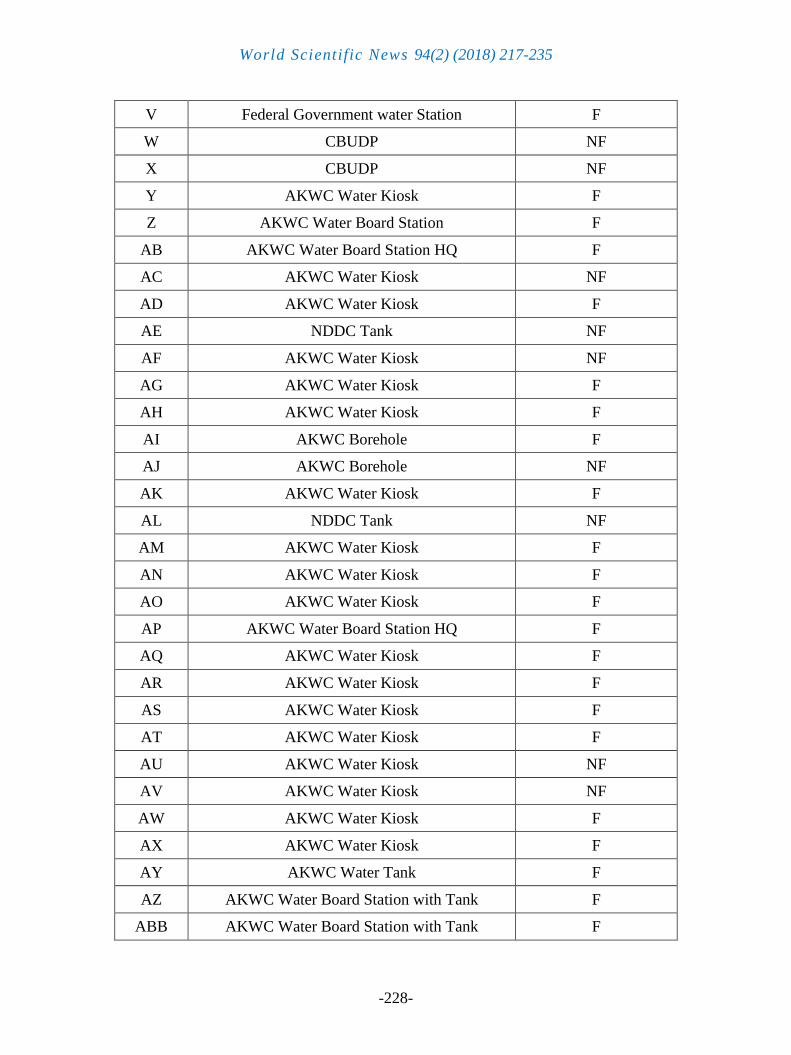
Table 3. Type of Water Source and their functionality (Yes)
Code Type of water source State of Functionality
A NDDC Tank NF
B NDDC Tank NF
C AKWC Water Board Tank F
D AKWC Water Kiosk NF
E AKWC Water Board Station F
F AKWC Water Kiosk F
G AKWC Water Board Station F
H AKWC Water Kiosk F
I AKWC Water Kiosk F
J MDGs Solar Powered F
K Federal Government water Station F
L AKWC Water Board Station F
M NDDC Tank NF
N Basin Authority Provided Water Tank NF
O AKWC Borehole F
P AKWC Borehole F
Q AKWC Borehole NF
R AKWC Borehole F
S AKWC Borehole NF
T AKWC Borehole NF
U Federal Government water Station F
World Scientific News 94(2) (2018) 217-235
-228-
V Federal Government water Station F
W CBUDP NF
X CBUDP NF
Y AKWC Water Kiosk F
Z AKWC Water Board Station F
AB AKWC Water Board Station HQ F
AC AKWC Water Kiosk NF
AD AKWC Water Kiosk F
AE NDDC Tank NF
AF AKWC Water Kiosk NF
AG AKWC Water Kiosk F
AH AKWC Water Kiosk F
AI AKWC Borehole F
AJ AKWC Borehole NF
AK AKWC Water Kiosk F
AL NDDC Tank NF
AM AKWC Water Kiosk F
AN AKWC Water Kiosk F
AO AKWC Water Kiosk F
AP AKWC Water Board Station HQ F
AQ AKWC Water Kiosk F
AR AKWC Water Kiosk F
AS AKWC Water Kiosk F
AT AKWC Water Kiosk F
AU AKWC Water Kiosk NF
AV AKWC Water Kiosk NF
AW AKWC Water Kiosk F
AX AKWC Water Kiosk F
AY AKWC Water Tank F
AZ AKWC Water Board Station with Tank F
ABB AKWC Water Board Station with Tank F
World Scientific News 94(2) (2018) 217-235
-229-
ABC NNPC/Mobil Producing Nigerian Joint Venture NF
ABD Federal Government water Station F
ABE AKWC Water Kiosk F
ABF AKWC Water Kiosk F
ABG AKWC Water Kiosk F
ABH Ibom Connection -
F = Functional, NF = Not Functional
Figure 2. 2D Contour map of the study area altitude
World Scientific News 94(2) (2018) 217-235
-230-
Distance (km)
Alt
itu
de
(m
)
121086420
80
75
70
65
60
55
50
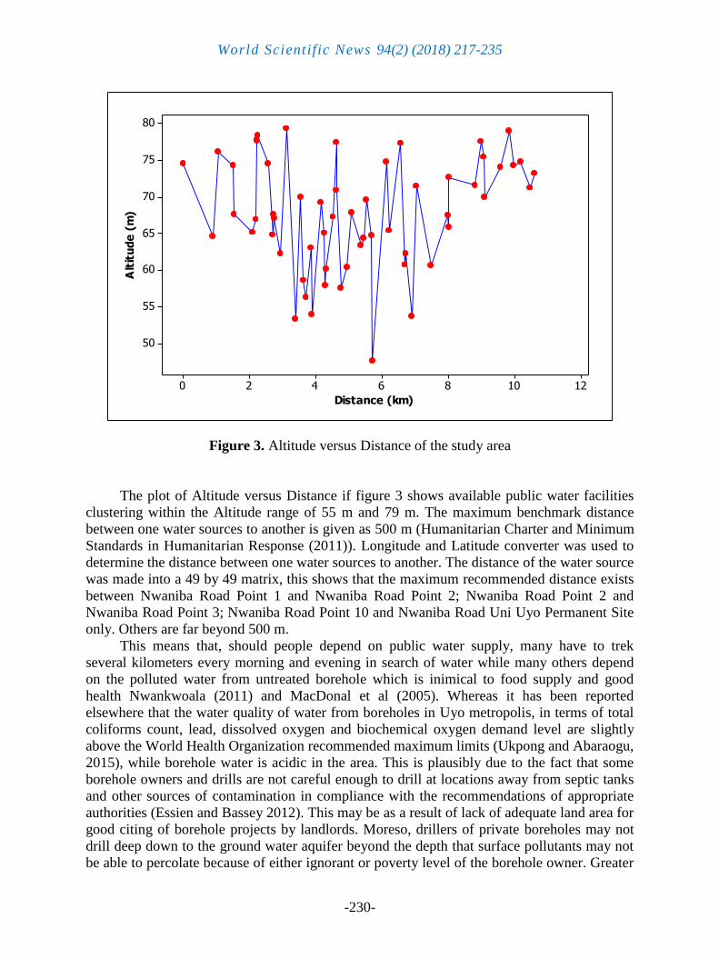
Figure 3. Altitude versus Distance of the study area
The plot of Altitude versus Distance if figure 3 shows available public water facilities
clustering within the Altitude range of 55 m and 79 m. The maximum benchmark distance
between one water sources to another is given as 500 m (Humanitarian Charter and Minimum
Standards in Humanitarian Response (2011)). Longitude and Latitude converter was used to
determine the distance between one water sources to another. The distance of the water source
was made into a 49 by 49 matrix, this shows that the maximum recommended distance exists
between Nwaniba Road Point 1 and Nwaniba Road Point 2; Nwaniba Road Point 2 and
Nwaniba Road Point 3; Nwaniba Road Point 10 and Nwaniba Road Uni Uyo Permanent Site
only. Others are far beyond 500 m.
This means that, should people depend on public water supply, many have to trek
several kilometers every morning and evening in search of water while many others depend
on the polluted water from untreated borehole which is inimical to food supply and good
health Nwankwoala (2011) and MacDonal et al (2005). Whereas it has been reported
elsewhere that the water quality of water from boreholes in Uyo metropolis, in terms of total
coliforms count, lead, dissolved oxygen and biochemical oxygen demand level are slightly
above the World Health Organization recommended maximum limits (Ukpong and Abaraogu,
2015), while borehole water is acidic in the area. This is plausibly due to the fact that some
borehole owners and drills are not careful enough to drill at locations away from septic tanks
and other sources of contamination in compliance with the recommendations of appropriate
authorities (Essien and Bassey 2012). This may be as a result of lack of adequate land area for
good citing of borehole projects by landlords. Moreso, drillers of private boreholes may not
drill deep down to the ground water aquifer beyond the depth that surface pollutants may not
be able to percolate because of either ignorant or poverty level of the borehole owner. Greater
World Scientific News 94(2) (2018) 217-235
-231-
percentage of man hour that would have been used for other useful and productive activities
are used in search of water. This confirms the observation of Ibok and Daniel (2014) in the
case of rural water supply situation in the state. Moreso, the available public water facilities
are found mainly along the major streets of Nwaniba road, Oron road, Ikot Ekpene road and
Abak road, while the tributary streets do not access public water facilities. Some major streets
like Aka road, Udo umana, Udoudoma Street are completely left out of public water facilities,
hence perpetually patronizing and embracing private borehole water. Evidently, government
participation in water supply venture is poor and inadequate. Similarly the report of Akpan
and Aster (2010) shows that even rural areas of Akwa Ibom state has very poor access to
potable water supply.
6. CONCLUSIONS
Water is known to get contaminated easily at the slightest chance, hence, over
dependence on water source that do not guarantee healthy living and good sanitation is a
matter of serious concern. Water scarcity and poor water quality leads to poor sanitation and a
serious threat to food security and good health, impacting negatively on the work force and
development. Acknowledging water as the most important element to the world, describing it
as the life blood of the environment, essential to the survival of all living things, whether it is
plant, animal or human, it must be stressed that everything possible must be done to maintain
its quality and the life inside it for today and the future. The inadequate government
participation on matters of water supply portrays that in Africa, the right to safe water and
sanitation is a mere political utopia as several millions of people lack access to safe water and
basic sanitation. The need for water outweighs the need for crude oil and electricity. One can
survive without crude oil and electricity, but survival is entirely water dependent.
Development cannot be achieved where water demand outstrips available water supply.
It is surprising therefore to note that despite the role of water in food production,
promotion of good sanitation, good health, and sustainance of life, work force, vegetation and
ecosystem, industrial operations, building and construction projects less attention is paid to
water supply. In other words, nothing could be done without water, yet issues of water
scarcity and inadequate rarely attracts mass media major captions, even when the
consequences of water scarcity is worse than the effect of nuclear and chemical weapons.
Withdraw all the world water supply for only one week and the entire population of human
race would die. This means that nobody can do without water. Scarcity of water, therefore
requires more publicity and report than other issues. Plausibly, it is in the light of this that
access to clean drinkable water and basic sanitation is made a priority in the Millennium
Development Goals (MDGs) as adopted by Heads-of-State at the United Nations Millennium
Summit 2000. The result of our investigation reveals that public water supply situation within
the study area is inadequate, not evenly distributed and where the facilities are available the
supply is epileptic in nature.
Recommendations
Existing government owned water companies, cooperation and boards should be
restructured, strengthen and empowered for adequate water supply to the public.
World Scientific News 94(2) (2018) 217-235
-232-
Government Partnership with international water donor agencies such as water and
sanitation component of the European Union assisted Niger Delta Support Programme
(EU/NDSP), United Nations Development Programmes (UNDP) and African Development
Bank (ADB) among others for the purpose of providing potable water supply.
Government should allow for and encourage effective private sector participation by
apportioning land outside contaminated areas to private organization for clean and potable
water projects.
Government should put policies in place for companies operating to at least provide
clean a potable water to host communities
Well equips water quality control laboratories be set up for periodic and routine testing
of water quality from government water facilities and water donated by companies, donor
organizations and private borehole operators. Water facilities / borehole operators. Water
facilities / borehole that fail at any time to meet the required or recommended standard should
be sealed up and close down.
Water quality control board should be set up to ensure that water samples from water
sources are taken and tested and the result published and the control measures applied.
Private borehole operators should be made to register with the Board and the
Laboratories, their water sample should be taken by agents of the Board and Laboratories
every two months for testing.
Broken water pipes should be repaired or replaced immediately when noticed, to avoid
contamination of the water system.
Only men/women of honest report and integrity should be allowed to work in water
companies, serve on the board and in the quality control laboratories. This is necessary as the
consequences of corrupt workers in water supply organizations and agencies can be more
dangerous than that of terrorists.
Adequate security should be provided for water supply facilities and the accessories.
Electricity supply to water pumping units should not be interrupted, hence special
electricity lines be allotted or an alternative to electricity from solar or wind sources should be
provided to water sector for effective and continuous pumping, distribution and supply of
clean water
References
[1] Adedeji A, Babatude A and Aderemi A (2010). Hydro-chemical investigation of
Groundwater quality in selected locations in Uyo, Akwa Ibom State of Nigeria. New
York Science Journal, pp. 117-122.
[2] Agbasi O.E and Etuk S.E (2016). Hydro-geoelectric study of Aquifer potential in parts
of Ikot Abasi local government area, Akwa Ibom state, using electrical resistivity
soundings. International Journal of Geology and Earth Sciences 2(4): 43-4.
[3] Akpan P.A and Atser J (2010). Accessibility levels to potable water supply in Rural
Areas of Akwa Ibom State, Nigeria. Ethiopian Journal of Environmental Studies in
Management, 3(2): 21-24.
World Scientific News 94(2) (2018) 217-235
-233-
[4] Akpabio, E.M and Ekanem E.M (2009). Water uncertainties in southeastern Nigeria:
Why government should be interested in Management. International Journal of
Sociology and Anthropology 1(2), 038-046.
[5] Badmus B.S, Oyedel T. Ojelabi E.A (2001). Electrical Resistivity soundings to
determine sub-surface contamination in the vicinity of refuse dump. Global Journal of
Pure and Applied Sciences, 7(1): 127-132.
[6] Chilson J (1996). Groundwater, Water quality Assessments, A guide to use of Biota.
Sediments and Water Environmental Monitoring 2nd
Edition pp. 1- 5.
[7] Efe S.I, Ogbam F.E, Horsfall M and Akporhonor E.E (2015). Seasonal variation of
physio-chemical characteristic of water resources quality in Western Niger Delta region,
Nigeria. Journal of Applied Science and Environmental Management. Pp. 191- 195.
[8] Ekong F. Jacob A and Ebong S (2012). Water Resource management in the Niger Delta
region of Nigeria: The role of Physical Planning. International review of social sciences
and Humanities, 3(1): 51-61.
[9] Elshazly A.H and Konsowa A.H (2003). Removal of Nickel ions from wastewater using
a cation-exchange resin in a batch-stirred tank reactor. Desalination, 158: 189-193.
[10] Essien O.E (2014). Comparative Pollution contribution of three point sources of
Pollution to Urban drainage stream degradation, Uyo. American Journal of Water
Resources 2(1): 10-17.
[11] Essien, O.E and Bassey E.D (2012). Spatial variation of Borehole water quality with
depth in Uyo municipality, Nigeria. International Journal of Environmental Science,
Management and Engineering Research, 1(1): 1-9.
[12] Etuk S.E, Nwokolo S and Agbasi O.E (2016a). Modelling and Estimating
Photosynthetically Active Radiation from Measured Global Solar Radiation at Calabar,
Nigeria. Physical Science International Journal 12(2): 1-12.
[13] Etuk S.E, Agbasi O.E and Nwokolo S. (2016b). Analysis of Photosynthetically Active
Radiation over six Tropical Ecological Zones in Nigeria. Journal of Geography,
Environment and Earth Science International, 7(4): 1-15.
[14] Frederiksen H, Berkoff J and Barber W. (1993). Water resources management in Asia
volume 1 main report. World Bank Technical paper number 21. Washington D.C.
World Bank.
[15] Garg S.K and Garg R (2008). Environmental studies and green technologies 1st Edition,
Delhi, Vineet Khanna pp. 50-71.
[16] George N.J, Nathaniel E.U and Etuk S.E (2014). Assessment of Economically
Accessible Groundwater Reserve and its protective capacity in Eastern Obolo Local
Government Area of Akwa Ibom State, Nigeria, using electrical resistivity method.
ISRN Geophysics, Hindawi, Volume 2014, pp. 1-10.
[17] Gleick P.H (2000). The changing water paradigm: A look at 25 century water resources
development. Water International 25(1): 127-138.
World Scientific News 94(2) (2018) 217-235
-234-
[18] Gleick P.H (1999). Water futures: A review of global water resources projection.
Oakland, California, USA, Pacific Institute for Studies in development, environment
and security.
[19] Gleick P.H (1998). The world’s water 1998 – 1999. The biennial report on freshwater
resources. Washington D.C. Island Press.
[20] Gleick P.H, Burns W.C.G, Chalecki E.I, Cohen M, Cushing K.K, Mann A, Reyes R,
Wolff G.H and Wong A.K (2002). The world’s water 2002 – 2003. The biennial report
on freshwater resources. Washington D.C Island Press.
[21] Hart P.C and White D (2006). Water quality and construction materials in rainwater
catchment across Alaska. Journal of Environmental Engineering Science 5(1): 519 –
525.
[22] Hinrichsen D, Robey B and Upadhyay (1998). Solution for a water-short world
population Reports, Series M. No 14. Baltimore, Md, USA: Johns Hopkins University
School of Public Health, Population Information program.
[23] Ibok E.E and Daniel E.E (2014). Rural water supply and sustainable development in
Nigeria: A case analysis of Akwa Ibom State. American Journal of Rural Development
2(4): 64-73.
[24] James E.E, Akpan P.A, Essien A.U, and Ekpo K.J (2012). The Pattern pf Housing-
health status among Residential zones in Uyo metropolis, Akwa Ibom state Nigeria.
Journal of Environmental Issues and Agriculture in Developing Countries, 4(3): 29-35.
[25] Jiya J.D and Bakare G.A (2002). Hydro and Biomass Electric Energy Cogeneration, A
perspective. In Proceedings of the National Conference of Energy Resources and
Development, February 2 at Center for Energy Research ATBU, Bauchi.
[26] Johnson N, Revenga C and Echeverria J. (2001). Managing water for people and nature.
Science 292: 1071-1072.
[27] Laouini G, Etuk, S.E and Agbasi O.E (2017). Delineation of Aquifers Using Dar
Zarrouk Parameters in Parts of Akwa Ibom, Niger Delta, Nigeria. Journal of
Hydrogeology and Hydrolic Engineering 6: 1. doi:10.4172/2325-9647.1000151.
[28] Lawal A, Adegbite A.A, Oduyiga O and Adebola A (2013). Determination and
delineation of Groundwater pollution from Leachate generated from dumpsite, Ijagun
community Odogbolu Southwestern Nigeria. American Academic and Scholarly
Research Journal, 5(1): 35-46.
[29] Lindsey B.D, Katz B.G, Berndt M.P, Andias A.F and Skach K.A (2006). Relations
between sinkholes density and anthropogenic contaminants in selected carbonate
aquifer in the eastern United State. Environmental Earth Science, 60(5): 1073-1090.
[30] MacDonald, A.M., Davies, J., Calow, C.L and Chilton, P.J. (2005). Developing
Groundwater: A guide for rural water supply. United Kingdom: ITDG publishing.
[31] Makeig K.S (1982). Natural buffers for sludge leachate stabilization. Groundwater 20:
420-429.
World Scientific News 94(2) (2018) 217-235
-235-
[32] Molden D.J (1997). Accounting for water use and productivity. System wide initiative
on water management SWIM paper no. 1. Colombo, Sri Lanka International Water
Management Institute.
[33] Molden D.J, Amarasinjhe U and Hussin I (2001). Water for rural development.
Working paper 32. Colombo, Sri Lanka International water Management Institute.
[34] Molden D.J, Sakthivadivel and Habib Z (2001). Basin level use and productivity of
water. Examples from south Asia. Research Report 49. Colombo, Sri Lanka:
International water management Institute.
[35] Nwankwoala A.O (2011). Localizing the strategy for achieving rural water supply and
sanitation in Nigeria. African Journal of Environmental Science and Technology 5(13),
29: 1170-1176.
[36] Oweis T and Hachum A (2001). Coping with increased water scarcity in dry areas:
ICARDA’s research to increase water productivity. Aleppo, Syria: International center
for Agricultural Research in the Dry Areas.
[37] Oweis T, Hachum A and Kijne J (1999). Water harvesting and supplementary irrigation
for improved water use efficiency in dry areas. SWIM paper 7. Colombo Sri Lanka:
international water management institute.
[38] Rosegrant M.W, Cai X. and Cline S.A (2002). World water and Food to 2025: Dealing
with scarcity. Washington, International Food Policy Research Institute.
[39] Shneider W.J (1970). Hydrologic implication of solid waste focus on environmental
Geology. (Edited by Ronald W. tank 1973), Oxford University Press, Inc. pp. 412-426.
[40] Smaktin V.U (2002). Environmental water need sand impacts of irrigated agriculture in
river basins: A framework for a new research program. Working paper 42. Colombo,
Sri Lanka: International Water Management Institute.
[41] Thompson W.E and Hickey J.V (1996). Society in Focus: An introduction to Sociology,
2nd
Edition Harper Collins College Publishers, pp. 16, 124, 125, 470-476.
[42] Ukpong E.C and Abaraogu U.J (2015). Comparative \analysis of Water Quality from
Hand Dug wells and boreholes in Uyo, Akwa Ibom State Nigeria. Civil Engineering
Portal, pp. 1-8.