Embed Size (px)
Citation preview


South Australian River Murray Long-Term Environmental Watering Plan Page i of 164
Cover photo: Red-necked avocets at the CLLMM © Kirsty Wedge
The Department of Environment, Water and Natural Resources and its employees do not warrant or make any representation regarding the use, or results of the use, of
the information contained herein as regards to its correctness, accuracy, reliability, currency or otherwise. The Department of Environment, Water and Natural Resources
and its employees expressly disclaim all liability or responsibility to any person using the information or advice. Information contained in this document is correct at the
time of writing.
© Crown in right of the State of South Australia, through the Department of Environment, Water and Natural Resources 2015
This work is Copyright. Apart from any use permitted under the Copyright Act 1968 (Cwlth), no part may be reproduced by any process without prior written permission
obtained from the Department of Environment, Water and Natural Resources. Requests and enquiries concerning reproduction and rights should be directed to the Chief
Executive, Department of Environment, Water and Natural Resources, GPO Box 1047, Adelaide SA 5001
Acknowledgement of the Traditional Owners
The Department of Environment, Water and Natural Resources acknowledges and pays respect to the Traditional owners, and their Nations, of the Murray-Darling Basin,
who have a deep cultural, social, environmental, spiritual and economic connection to their lands and waters.
The First Peoples of the River Murray and Mallee Region (FPRMM) and the Ngarrindjeri Nation have occupied, enjoyed, managed and used their inherited lands and
waters of the River Murray, Lakes and Coorong since time immemorial. They pay respect to their Creators, ancestors, elders, and young people who have cared for their
country since creation.

South Australian River Murray Long-Term Environmental Watering Plan Page ii of 164
Foreword
Sustainable management of freshwater resources into the future is one of the most critical challenges facing
global communities. By international standards, significant progress towards more sustainable management
practices has been made in the Murray-Darling Basin with numerous policy and legislative reforms, and roll-out
of on-ground river and wetland restoration programmes, including infrastructure to aid in environmental water
management. Perhaps most significantly within the Basin has been the decision under the Murray-Darling Basin
Plan (2012) to commit to returning 2,750 GL of water to the system. This is a key step towards restoring some of
the balance between meeting the needs of the environment while still providing for productive industries and
communities, including water for irrigation and critical human water needs.
Despite the efforts made to date, ongoing and concerted effort will be required to restore a healthy, working
Murray-Darling Basin. South Australia, in partnership with other Basin States, the Murray-Darling Basin Authority
(MDBA), the Commonwealth Environmental Water Holder (CEWH), local communities and non-government
organisations, is progressing well in implementing the Basin Plan, including the environmental water
management framework set out in Chapter 8 of that document.
To this end, South Australia is pleased to present this long-term environmental watering plan. It is the first to be
developed for the South Australian River Murray Water Resource Plan Area in accordance with the environmental
management framework within the Basin Plan and is based on the most recent available scientific knowledge and
understanding of the South Australian River Murray ecosystem. This long-term plan complements and builds on
the 2014 release of the Basin-wide Environmental Watering Strategy by the MDBA, as well as work completed in
South Australia’s annual environmental watering plans and many long-running environmental water management
projects.

South Australian River Murray Long-Term Environmental Watering Plan Page iii of 164
Contents
Foreword .................................................................................................................................................................................................................... ii
Contents ................................................................................................................................................................................................................... iii
Glossary ........................................................................................................................................................................................................................ i
Executive Summary ................................................................................................................................................................................................ v
1 Introduction .................................................................................................................................................................................................. 5
2 Context............................................................................................................................................................................................................ 8
2.1 Planning area .................................................................................................................................................................................... 8
2.2 Planning timeframe ........................................................................................................................................................................ 8
2.3 Consistency with preparation requirements ..................................................................................................................... 10
2.3.1 Consultation .............................................................................................................................................................................. 10
2.3.2 Basin-Wide Environmental Watering Strategy ........................................................................................................... 11
2.3.3 International agreements .................................................................................................................................................... 11
2.4 Environmental water availability and management ....................................................................................................... 13
2.4.1 Types of environmental water ........................................................................................................................................... 13
2.4.2 South Australia's Entitlement ............................................................................................................................................. 13
2.4.3 Flows above South Australia's Entitlement .................................................................................................................. 15
2.4.4 Environmental water holders ............................................................................................................................................. 15
2.4.5 Managers of planned environmental water ................................................................................................................. 16
2.4.6 Environmental site managers ............................................................................................................................................. 17
3 Ecology ......................................................................................................................................................................................................... 19
3.1 Asset scale ........................................................................................................................................................................................ 19
3.2 Identifying ecological objectives, targets and environmental water requirements for the priority
environmental assets .................................................................................................................................................................................... 20
3.2.1 Having regard for groundwater ........................................................................................................................................ 21
3.2.2 Integration of Indigenous knowledge ............................................................................................................................ 21
3.3 The SA River Murray Channel Priority Environmental Asset ....................................................................................... 25
3.3.1 Location and geographic extent ....................................................................................................................................... 25
3.3.2 Conservation significance .................................................................................................................................................... 25
3.3.3 Ecological attributes ............................................................................................................................................................... 26
3.3.4 Ecological objectives, targets and environmental water requirements ........................................................... 26
3.4 The SA River Murray Floodplain Priority Environmental Asset .................................................................................. 34

South Australian River Murray Long-Term Environmental Watering Plan Page iv of 164
3.4.1 Location and geographic extent ....................................................................................................................................... 34
3.4.2 Conservation significance .................................................................................................................................................... 35
3.4.3 Ecological attributes ............................................................................................................................................................... 35
3.4.4 Ecological objectives, targets and environmental water requirements ........................................................... 36
3.5 The Coorong, Lower Lakes and Murray Mouth Priority Environmental Asset .................................................... 47
3.5.1 Location and geographic extent ....................................................................................................................................... 47
3.5.2 Conservation significance .................................................................................................................................................... 48
3.5.3 Ecological attributes ............................................................................................................................................................... 50
3.5.4 Ecological objectives, targets and environmental water requirements ........................................................... 50
3.6 Application of the environmental water requirements ................................................................................................. 59
3.6.1 EWRs contribution to targets ............................................................................................................................................. 59
3.6.2 EWRs and annual planning ................................................................................................................................................. 59
3.6.3 EWRs and management levers .......................................................................................................................................... 60
3.7 Priority ecosystem functions .................................................................................................................................................... 77
3.7.1 Alignment of environmental water requirements ..................................................................................................... 79
4 Management considerations ............................................................................................................................................................... 83
4.1 Indigenous values ......................................................................................................................................................................... 83
4.1.1 Ngarrindjeri cultural values ................................................................................................................................................. 83
4.1.2 Ngarrindjeri involvement in environmental water planning ................................................................................. 86
4.1.3 First Peoples of the River Murray and Mallee Region cultural values .............................................................. 87
4.1.4 First Peoples of the River Murray and Mallee Region involvement in environmental water planning
88
4.1.5 Integrating Indigenous values ........................................................................................................................................... 88
4.2 Possible co-operative arrangements .................................................................................................................................... 89
4.2.1 Cooperative arrangements within the SA River Murray Water Resource Plan Area................................... 89
4.2.2 Cooperative arrangements with upstream water resource plan areas ............................................................. 96
4.2.3 Cooperative arrangements between water resource plan areas within SA .................................................... 96
4.3 Operational constraints .............................................................................................................................................................. 97
4.3.1 Definitions .................................................................................................................................................................................. 97
4.3.2 Existing work on flow constraints ..................................................................................................................................... 98
4.3.3 Other constraints and management strategies ....................................................................................................... 101
4.4 Long-term risks to providing environmental water .................................................................................................... 105
4.4.1 Identification of risks .......................................................................................................................................................... 105
South Australian River Murray Long-Term Environmental Watering Plan Page v of 164
4.4.2 Potential risk mitigation strategies ............................................................................................................................... 106
5 Monitoring, evaluation, reporting and improvement ............................................................................................................ 112
5.1 Environmental water reporting requirements ............................................................................................................... 112
5.1.1 Basin Plan reporting requirements ............................................................................................................................... 112
5.1.2 Other reporting requirements ........................................................................................................................................ 113
5.2 Integrated monitoring and evaluation plan ................................................................................................................... 113
5.3 Review of this plan .................................................................................................................................................................... 114
6 Bibliography............................................................................................................................................................................................. 116
List of Appendices
Appendix 1. Alignment of BWEWS expected outcomes with ecological objectives of the SA River Murray WRP
Area priority environmental assets ............................................................................................................................................................ 122
Appendix 2. Definitions of held and planned environmental water ........................................................................................... 131
Appendix 3. Species of conservation significance recorded within SA River Murray WRP Area Priority
Environmental Assets ...................................................................................................................................................................................... 132
Appendix 4. Species lists for the CLLMM Priority Environmental Asset ecological targets .............................................. 146
Appendix 5. Historical pump sites within the Channel and Floodplain Priority Environmental Assets ........................ 151
List of Tables
Table 1. Ramsar Wetlands in the SA River Murray WRP Area........................................................................................................... 12
Table 2. Summary of held (HEW) and planned (PEW) environmental water within the SA River Murray WRP Area 14
Table 3. Ecological objectives and targets for the SA River Murray Channel Priority Environmental Asset ................. 29
Table 4. Environmental Water Requirements for the SA River Murray Channel Priority Environmental Asset ........... 34
Table 5. Ecological objectives and targets for the SA River Murray Floodplain Priority Environmental Asset ............ 39
Table 6. Environmental Water Requirements for the SA River Murray Floodplain Priority Environmental Asset....... 47
Table 7. Ecological objectives and targets for the Coorong, Lower Lakes and Murray Mouth Priority Environmental
Asset .......................................................................................................................................................................................................................... 54
Table 8. Environmental Water Requirements for the Coorong, Lower Lakes and Murray Mouth Priority
Environmental Asset ........................................................................................................................................................................................... 58
Table 9. Assessment of contribution of SA River Murray Channel Priority Environmental Asset EWRs towards
Ecological Targets ................................................................................................................................................................................................ 62
Table 10. Assessment of contribution of SA River Murray Floodplain Priority Environmental Asset EWRs towards
Ecological Targets ................................................................................................................................................................................................ 66
Table 11. Assessment of contribution of Coorong, Lower Lakes and Murray Mouth Priority Environmental Asset
EWRs towards Ecological Targets ................................................................................................................................................................. 72
South Australian River Murray Long-Term Environmental Watering Plan Page vi of 164
Table 12. Priority ecosystem functions and associated ecological objectives for the SA River Murray WRP Area .... 78
Table 13. Alignment of Channel and Floodplain EWRs with CLLMM EWRs ............................................................................... 81
Table 14. Cooperative arrangements for environmental water management within the SA River Murray WRP Area
..................................................................................................................................................................................................................................... 91
Table 15. Key flow constraints for the SA River Murray WRP Area being addressed through the CMS and PPMs 100
Table 16. Flow constraints that influence environmental water management along the Lower Murray in South
Australia ................................................................................................................................................................................................................ 103
Table 17. Matrix of risks and consequences that impact on providing the EWRs of the SA River Murray WRP Area
.................................................................................................................................................................................................................................. 108
Table 18. Reporting requirements for Basin States relating to Basin Plan Chapter 8 Environmental Watering Plan
.................................................................................................................................................................................................................................. 112
Table 19. Threatened plant species ........................................................................................................................................................... 132
Table 20. Threatened fauna species .......................................................................................................................................................... 138
Table 21. TLM target waterbird species .................................................................................................................................................. 146
Table 22. Waterbird species that breed annually in the CLLMM .................................................................................................. 147
Table 23. Waterbird species that breed regularly in the CLLMM ................................................................................................. 147
Table 24. Waterbird species that should be present in the CLLMM in abundances >1% of current flyway
thresholds ............................................................................................................................................................................................................ 148
Table 25. Common CLLMM fish families................................................................................................................................................. 149
Table 26. Commence-to-flows (ML/day QSA) for selected temporary wetlands within the SA River Murray WRP
Area......................................................................................................................................................................................................................... 151
List of Figures
Figure 1. Comparison of the planning area of the SA River Murray LTWP to the SA River Murray WRP Area ............. 9
Figure 2. South Australian River Murray entitlement delivery pattern (at full entitlement) ................................................. 14
Figure 3. Map of the three environmental assets within the SA River Murray WRP Area .................................................... 23
Figure 4. Map of the three priority environmental assets within the SA River Murray WRP Area .................................... 24
Figure 5. Spatial extent of the Channel Priority Environmental Asset between the border and Swan Reach .............. 27
Figure 6. Spatial extent of the Channel Priority Environmental Asset between Swan Reach and Wellington ............. 28
Figure 7. Spatial extent of the Floodplain Priority Environmental Asset between the border and Swan Reach ......... 37
Figure 8. Spatial extent of the Floodplain Priority Environmental Asset between Swan Reach and Wellington ........ 38
Figure 9. Spatial extent of the Coorong, Lower Lakes and Murray Mouth Priority Environmental Asset ...................... 52
Figure 10. Hypothetical optimal timing of barrage releases for various annual flow scenarios ........................................ 53
Figure 11. Timeframes for SA River Murray LTWP, PPMs and CMS implementation .......................................................... 102

South Australian River Murray Long-Term Environmental Watering Plan Page i of 164
Glossary
Basin State Defined in the Water Act 2007 to mean (a) New South Wales; (b) Victoria;
(c) Queensland; (d) South Australia; (e) the Australian Capital Territory.
Bonn Convention The Convention on the Conservation of Migratory Species of Wild Animals -
an environmental treaty aimed at conserving terrestrial, aquatic and avian
migratory species throughout their range.
BWEWS Basin-Wide Environmental Watering Strategy – published by the Murray-
Darling Basin Authority, a legislative requirement under Chapter 8 of the
Basin Plan.
CAMBA China-Australia Migratory Bird Agreement – a bilateral agreement to protect
and conserve migratory birds and their habitat.
CEW Commonwealth Environmental Water.
CEWH Commonwealth Environmental Water Holder.
CEWO Commonwealth Environmental Water Office.
CLLMM Coorong, Lower Lakes and Murray Mouth.
CLLMM Recovery Project Coorong and Lower Lakes Recovery Project - one of DEWNR's major
programmes, with funding from the Australian Government.
CMS Constraints Management Strategy - strategy published by the Murray-
Darling Basin Authority in 2013 that identifies further work to be undertaken
on physical constraints.
CPS Components, processes and services – attributes that are identified and
described in the ecological character descriptions of Ramsar wetlands.
DEWNR South Australian Department of Environment, Water and Natural Resources.
Discharge The volumetric flow rate of water i.e. volume of streamflow over a given
time. In South Australia, this is often represented as ML/day.
ECD Ecological character description - provides a description of a Ramsar wetland
at the time of listing, where ecological character is the ecosystem
components, processes, benefits and services that characterise the wetland.
It can be used to assist in the assessment of possible change in the
ecological character of the wetland.
EPBC Act Environment Protection and Biodiversity and Conservation Act 1999.
South Australian River Murray Long-Term Environmental Watering Plan Page ii of 164
EWR Environmental water requirement - the water regime needed to sustain the
ecological values of aquatic ecosystems and biological diversity at a low level
of risk.
FPRMM First Peoples of the River Murray and Mallee Region - native title holders in the
Riverland, South Australia, including areas of the River Murray around Renmark,
Berri, Barmera, Waikerie and Morgan.
GL Gigalitres – a measure of volume, where a gigalitre equals 1,000 megalitres
or 1,000,000,000 litres.
HEW Held environmental water – defined within Section 4 of the Water Act 2007.
JAMBA Japan-Australia Migratory Bird Agreement – a bilateral agreement to protect
and conserve migratory birds and their habitat.
KNYA Kungun Ngarrindjeri Yunnan Agreement.
LAC Limits of acceptable change - used in a Ramsar context to define and detect
a change in the ecological character of wetlands.
Lower Lakes Lakes Alexandrina and Albert.
LTAAY Long-term average annual yield.
LTWP Long-term environmental watering plan – a legislative requirement under
Chapter 8 of the Basin Plan.
MDBA Murray-Darling Basin Authority.
ML/day Megalitres per day – a measure of flow or discharge, where a megalitre
equals 1,000,000 litres.
NRA Ngarrindjeri Regional Authority - the peak regional organisation of the
Ngarrindjeri people, descendants of the original indigenous inhabitants of
the lands and waters of the Murray River, Lower Lakes and Coorong and
adjacent areas.
PEA Priority Environmental Asset – defined in s8.49 of the Basin Plan as an
environmental asset that can be managed with environmental water.
PEF Priority Environmental Function - defined in s8.50 of the Basin Plan as an
ecosystem functions that can be managed with environmental water.

South Australian River Murray Long-Term Environmental Watering Plan Page iii of 164
PEW Planned environmental water – defined in Section 6 of the Water Act 2007.
Pool-connected wetland A wetland that can be connected to the main River channel when South
Australia is receiving its Entitlement and normal operating pool levels are
being maintained.
PPM Pre-requisite policy measure - constraints that coincide with the
unimplemented policy measures identified in s7.15 of the Basin Plan.
QSA Flow at the South Australian border. Unless otherwise stated, flow rates (or
discharges) are expressed with respect to flow at the South Australian
border.
RRP Riverine Recovery Project - one of DEWNR's major programmes, with
funding from the Australian Government.
ROKAMBA Republic of Korea-Australia Migratory Bird Agreement – a bilateral
agreement to protect and conserve migratory birds and their habitat.
SARFIIP South Australian Riverland Floodplain Integrated Infrastructure Program -
one of DEWNR's major programmes, with funding from the Australian
Government.
SA River Murray LTWP The Long-Term Environmental Watering Plan for the South Australian River
Murray Water Resource Plan Area.
SA River Murray WRP Area
Also SARM
South Australian River Murray Water Resource Plan Area – defined in
Chapter 3 of the Basin Plan. For the purposes of this plan, the Coorong is
considered as part of this water resource plan area.
SCB Southern Connected Basin - a collective term for the valleys located in the
southern section of the Murray-Darling Basin, including Goulburn,
Campaspe, Loddon, Murray (NSW, Victorian and South Australian),
Murrumbidgee and Lower Darling.
SCBEWC Southern Connected Basin Environmental Watering Committee - a multi-
jurisdictional committee that provides advice on the coordinated delivery of
environmental water.
SDL Sustainable diversion limit – defined in the Basin Plan as the long-term
average sustainable diversion limit.
Temporary wetland A wetland basin that is not connected to the main River channel when South
Australia is receiving its Entitlement flows and normal operating pool levels
are being maintained.

South Australian River Murray Long-Term Environmental Watering Plan Page iv of 164
TLM The Living Murray Program – a long-running collaborative programme
between the Murray-Darling Basin Authority and partner governments
aimed at restoring the health of the River Murray system by recovering
500 gigalitres of water and constructing major water management structures
at six environmental icon sites.
UNDRIP United Nations Declaration on the Rights of Indigenous Peoples.
VEWH Victorian Environmental Water Holder.
WRP Area Water Resource Plan Area – water planning units identified for the purpose
of implementing the Basin Plan. The water resource plan areas are listed in
Chapter 3 of the Basin Plan.
South Australian River Murray Long-Term Environmental Watering Plan Page v of 164
Executive Summary
The purpose of this long-term environmental watering plan (LTWP) is to set out the priority environmental assets
of the South Australian River Murray Water Resource Plan Area (SA River Murray WRP Area) and the
environmental objectives, targets and environmental water requirements (EWRs) to be achieved for those assets
over the longer term.
The LTWP is of strategic importance for the management of the South Australian River Murray, its floodplain and
wetlands, and the Coorong, Lower Lakes and Murray Mouth (CLLMM). It provides direction for the most efficient
and effective use of environmental water. Environmental water holders and managers will use the content of this
LTWP in future environmental water decision making, including to inform the coordination of Basin-wide
watering actions.
The SA River Murray WRP Area includes the River Murray and its floodplain (defined by the 1956 flood extent),
from the South Australian/New South Wales/Victorian border (the border) to the Murray Mouth, and includes
Lakes Alexandrina and Albert (the Lower Lakes). This LTWP also incorporates the Coorong. Although considered
by the Basin Plan to be part of the South Australian Murray Region Water Resource Plan Area, ecological
outcomes in the Coorong are driven by surface water inputs from the River Murray via the Lower Lakes.
Therefore, the Coorong is addressed in this LTWP, consistent with the approach taken by South Australia for
annual environmental water planning and prioritisation under the Basin Plan.
A landscape-scale approach has been used to define the environmental assets to reflect the ecological
importance of the mosaic of habitats, rather than focussing on discrete management units that represent only a
small portion of the SA River Murray WRP Area. It also ensures that a holistic approach is taken to environmental
water planning, delivery and evaluation.
Three priority environmental assets have been identified for the SA River Murray WRP Area:
the Coorong, Lower Lakes and Murray Mouth Priority Environmental Asset ('the CLLMM PEA') - equivalent to
the Lower Lakes, Coorong and Murray Mouth TLM Icon Site and the Coorong, Lakes Alexandrina and Albert
Ramsar Wetland of International Importance
the South Australian River Murray Channel Priority Environmental Asset ('the Channel PEA') - consists of the
area between Wellington, South Australia, and the border - a total distance of approximately 560 River
kilometres. The lateral extent comprises the area inundated at flows up to 40,000 ML/day QSA (i.e. flow
measured at the border) under normal River operations
the South Australian River Murray Floodplain Priority Environmental Asset ('the Floodplain PEA') an
equivalent longitudinal extent to the Channel PEA, extending from Wellington, South Australia, to the border,
and consists of the area that is inundated when flows are between 40,000 ML/day QSA and 80,000 ML/day
QSA (under normal River operations).
The outer floodplain (i.e. the area that requires flows above 80,000 ML/day QSA to be inundated) is not included
as part of the Floodplain PEA as the Basin Plan defines a priority environmental asset as an environmental asset
that can be managed with environmental water (s8.49) and Murray-Darling Basin Authority (MDBA) modelling
indicates that 80,000 ML/day QSA is the maximum flow rate at which active management of environmental water
can occur (subject to the implementation of measures to address flow constraints). The outer floodplain
represents approximately 40% of the whole floodplain. Despite not being part of the Floodplain PEA, the outer
floodplain is still considered to be an area of high importance to South Australia for many reasons, including

South Australian River Murray Long-Term Environmental Watering Plan Page ii of 164
supporting a large proportion of the black box woodlands within the water resource plan area (WRP Area), and
connecting riparian zones with upland habitats. It is therefore critical that there is no further reduction in the
occurrence of the unregulated flow events that are required to inundate the outer floodplain (Government of
South Australia, 2012).
In total, 45 ecological objectives, 98 ecological targets and 16 EWRs were identified for the three priority
environmental assets. They represent what is needed to support each of the priority environmental assets in a
healthy, functioning state. Extensive effort has been directed to ensuring that this plan is based on the best
scientific knowledge.
An overall theme of the EWRs is the reinstatement of a more natural flow regime through the delivery of
environmental water to the South Australian border, and downstream to the CLLMM. To meet the majority of the
EWRs, environmental water will need to be delivered in conjunction with unregulated flows, as the volume of
water required is greater than that provided by South Australia's Entitlement alone or available to the
environment through water recovery programmes.
The EWRs describe a desired long-term and variable hydrological regime that enables flexibility and adaptive
management in response to climate and ecological condition. The EWRs can be used in annual planning to
identify vital watering actions together with results from ecological monitoring that indicate current condition,
need for water and risk of not watering.
In addition to the ecological information provided, the following management considerations will continue to be
taken into account during future annual and long term planning and decision-making:
Indigenous values – consideration of, and where possible alignment with, Indigenous values in order to
maximise the benefits from environmental watering
Cooperative arrangements – processes to be followed to ensure that watering actions across the WRP Area
and Southern Connected Basin (SCB) are coordinated
Operational constraints – whether it is feasible to deliver the proposed watering action in view of operational
constraints
Long-term risks to providing environmental water – whether the proposed watering action addresses any of
the potential long-term risks.
South Australia recognises the importance of and is committed to seeking and incorporating Indigenous values
and uses in the development of environmental water plans where possible. Within the SA River Murray WRP Area,
Indigenous engagement in environmental water planning has occurred for many years with the Ngarrindjeri
Regional Authority (NRA) and the First Peoples of the River Murray and Mallee Region (FPRMM) through formal
agreements with the South Australian Government. Further collaboration between the FPRMM, Natural Resources
SA Murray-Darling Basin and DEWNR, has enabled the inclusion of FPRMM's perspectives into the management
of wetland and floodplain areas. Crucial to the strong working partnership that has developed between
Ngarrindjeri and DEWNR staff are the Kungun Ngarrindjeri Yunnan Agreement (KNYA) strategy of engagement
and the Ngarrindjeri Yarluwar Ruwe (NYR) caring for country programme, which have facilitated active
Ngarrindjeri participation in the CLLMM TLM Icon Site Program, Riverine Recovery Project and CLLMM Project,
and involvement in environmental water planning for the CLLMM, Channel and Floodplain Assets for a number of
years.
Cooperative arrangements within the WRP Area have been described for each phase of environmental water
management. These arrangements are needed to ensure all environmental asset and site managers,
environmental water holders and environmental water managers are working towards the common goal for the
SA River Murray WRP Area of a healthy, functioning and resilient ecosystem. They lead to decisions that are

South Australian River Murray Long-Term Environmental Watering Plan Page iii of 164
transparent, priorities and trade-offs that are understood, and outcomes at the site-scale that contribute to
desired outcomes at the LTWP asset and WRP Area scale.
Cooperative arrangements between upstream WRP Areas and the SA River Murray WRP Area will be progressed
through the development of an integrated plan for environmental watering in the Southern Connected Basin
(SCB). South Australia will work closely with the other Basin States, the MDBA and the CEWH to develop this plan.
Constraints have a significant impact on the feasibility of delivering environmental water to and within the SA
River Murray WRP Area. The constraints currently having the greatest impact on environmental water
management in the SA River Murray WRP Area are generally being addressed through the Constraints
Management Strategy (CMS) or the policy measures relating to the sustainable diversion limit (SDL) adjustment
mechanism.
Key long-term risks to providing environmental water include:
insufficient water available for SA River Murray WRP Area priority assets/functions
water cannot be delivered to SA River Murray WRP Area priority assets/functions
water quality is unsuitable for use at SA River Murray WRP Area priority assets/functions.
Key mechanisms for addressing these long-term risks include effective decision-making frameworks; addressing
flow constraints, and rigorous monitoring and evaluation programmes.
Effective monitoring, evaluation and reporting will be critical to assessing both the effectiveness of this LTWP and
the Basin Plan environmental watering framework more generally. An integrated monitoring and evaluation plan
for the SA River Murray WRP Area is proposed, with a particular focus on meeting the state's requirement to
report against Basin Plan Matter 8 (the achievement of environmental outcomes at an asset scale). This LTWP
represents what is needed to support a healthy, functioning ecosystem and has not been restricted to what is
achievable under the Basin Plan, nor what is likely to be monitored in the future. The integrated monitoring and
evaluation plan will therefore seek to quantify expected outcomes (consistent with the ecological targets) and
prioritise monitoring indicators.
Review and update of this LTWP will ensure that it retains relevance and currency, and this must occur on at least
a five yearly basis.

South Australian River Murray Long-Term Environmental Watering Plan Page 4 of 164
Photo: Irwin Flat and Donald Flat Wetlands © Callie Nickolai

South Australian River Murray Long-Term Environmental Watering Plan Page 5 of 164
1 Introduction
This long-term environmental watering plan (LTWP) is the first to be developed for the South Australian River
Murray Water Resource Plan Area (SA River Murray WRP Area) in accordance with the environmental
management framework within the Basin Plan. It builds on many years of annual environmental water planning
and integrates the information developed through many long-running and successful projects and programmes
within the region.
These projects and programmes are focussed on addressing the major impacts arising from a long history of
River regulation and development. Extractions for consumptive use and upstream storages have caused a
reduction in the flows needed to generate within-channel pulses and overbank inundation, and provide water to
the Lower Lakes, Murray Mouth and the Coorong. In addition, the construction of six weirs along the main
channel of the River Murray in South Australia has stabilised water levels and slowed water velocities, creating
lentic 'weir pools'. Together, these impacts have resulted in a decline in the ecological condition of the River, and
its floodplain, wetlands and estuary. Indigenous nation groups within the SA River Murray WRP Area such as the
Ngarrindjeri rely on the interconnectivity between land, waters, spirit and all living things (Ngarrindjeri refer to this as
Ruwe/Ruwar), and a decline in the ecological condition of the River system can also be understood as a threat to their
health and wellbeing.
In addition to being a legislated requirement under Chapter 8 of the Basin Plan, this LTWP provides an
opportunity for South Australia to present the hydrological regimes needed to support a healthy, functioning
South Australian River Murray ecosystem. The overall environmental objectives for the water-dependent
ecosystems of the SA River Murray WRP Area are derived from those identified in the Basin Plan for the Murray-
Darling Basin (s8.04), as follows:
to protect and restore water-dependent ecosystems of the SA River Murray WRP Area
to protect and restore the ecosystem functions of water-dependent ecosystems
to ensure that water-dependent ecosystems are resilient to climate change, and other risks and threats.
This LTWP assists to meet these goals by:
providing a common understanding of the priority environmental assets and the hydrological regimes
needed to support them in a healthy, functioning state
identifying priority ecosystem functions that focus on linking the assets and aligning environmental water
management across the assets
consolidating ecological information that will facilitate annual environmental water planning and
prioritisation, and inform negotiations with water holders
identifying constraints to the successful delivery of environmental water to and within the water resource
plan area
outlining the mechanisms in place to assist with coordinating environmental watering throughout the region,
and ensure priorities and any trade-offs are transparent
providing a basis for evaluating the success of environmental water management and improving future
versions of this LTWP.

South Australian River Murray Long-Term Environmental Watering Plan Page 6 of 164
The information within this LTWP is presented in the following sections:
Section 2 Context - Explains the spatial and temporal scale of the plan, and the processes and consistencies
required under the Basin Plan that were followed when preparing the plan. It also identifies the types and
volumes of environmental water potentially available, and the parties responsible for managing the water and
environmental assets or sites in the region.
Section 3 Ecology - Describes the priority environmental assets and priority ecosystem functions identified within
the SA River Murray WRP Area and the process used to identify them. A suite of ecological objectives, targets and
environmental water requirements (EWRs) is provided for each. Guidance on the use of the ecological content in
annual and real-time planning is also provided.
Section 4 Management considerations - There are many other factors which need to be taken into account during
decision-making or which influence the feasibility of delivering water. Some of these critical factors have been
described, including Indigenous values and uses, with a particular focus on those requiring description under the
Basin Plan environmental water management framework.
Section 5 Monitoring, evaluation, reporting and improvement - A summary of environmental water reporting
requirements is provided, as well as the proposed mechanism for reporting on the achievement of environmental
outcomes at an asset scale.

South Australian River Murray Long-Term Environmental Watering Plan Page 7 of 164
Photo: Lignum flowers © Emily Hoffmann

South Australian River Murray Long-Term Environmental Watering Plan Page 8 of 164
2 Context
2.1 Planning area
This LTWP has been developed for the SA River Murray WRP Area, which is defined in Chapter 3 of the Basin Plan.
The SA River Murray WRP Area includes the River Murray and its floodplain (defined by the 1956 flood extent),
from the South Australian/New South Wales/Victorian border to the Murray Mouth, and includes Lakes
Alexandrina and Albert (the Lower Lakes).
This plan also incorporates the Coorong, which is considered by the Basin Plan to be part of the South Australian
Murray Region Water Resource Plan Area (SA Murray Region WRP Area) (Figure 1). Ecological outcomes in the
Coorong are driven by surface water inputs from the River Murray via the Lower Lakes, while the volume of
surface water arriving in the Coorong from the SA Murray Region WRP Area is small and the groundwater inputs
are not well quantified. The Coorong and Lower Lakes have long been treated as a single environmental asset or
site including recognition as a Wetland of International Importance under the Ramsar Convention on Wetlands
and as an icon site through The Living Murray Initiative. It is therefore appropriate for the EWRs of the Coorong
and the Lower Lakes to be included in the same LTWP.
Murrundi (River Murray), including the Kurangk (Coorong), Lakes and Murray Mouth, is an Indigenous cultural
landscape. The whole of the Kurangk (Coorong), Lakes and Murray Mouth site is part of the traditional lands and
waters of the Ngarrindjeri nation, the Ngarrindjeri & Ors (SAD 6027/98) native title claim and includes registered
Aboriginal sites such as the ‘Meeting of the Waters’. The First Peoples of the River Murray and Mallee Region
(FPRMM) have a native title consent determination applying to lands and waters of the upper Murray, including
the Riverland in South Australia.
2.2 Planning timeframe
The SA River Murray LTWP has an indicative timeframe of five years, covering the period November 2015 to
November 2020, and until a subsequent LTWP is released.
The Basin Plan outlines certain triggers for the review and updating of a LTWP, including the accreditation,
amendment or adoption of the water resource plan for the water resource plan area, or published updates to the
Basin-Wide Environmental Watering Strategy (BWEWS) that materially affect the LTWP. It is anticipated that the
first water resource plan for the SA River Murray WRP Area will be accredited in 2019, triggering a need to review
and update the SA River Murray LTWP. This aligns well with the timeframe of the SA River Murray LTWP.
The State may also choose to revise and update the SA River Murray LTWP at any time. Some examples include:
to reflect new learnings on ecological response to hydrology and hence an improved understanding of the assets’
EWRs; to reflect changes as a result of work currently underway on the revision of the ecological character
description of the Coorong Lakes Alexandrina and Albert Ramsar Wetland; to address integration issues identified
through cross-jurisdictional planning and management, or; to incorporate additional insights into ecological
connectivity and health gained through further Indigenous engagement in state water planning.
Photo: Lignum flowers © Emily Hoffmann

South Australian River Murray Long-Term Environmental Watering Plan Page 9 of 164
Figure 1. Comparison of the planning area of the SA River Murray LTWP to the SA River Murray WRP Area

South Australian River Murray Long-Term Environmental Watering Plan Page 10 of 164
2.3 Consistency with preparation requirements
The SA River Murray LTWP was developed by the South Australian Department of Environment, Water and
Natural Resources (DEWNR) in accordance with the preparation requirements described in Section 8.20 of the
Basin Plan. These requirements include:
consultation requirements
having regard to the Murray-Darling Basin Authority's BWEWS
consistency with the 11 principles to be applied in environmental watering
to not be inconsistent with relevant international agreements.
2.3.1 Consultation
This LTWP was prepared by staff within DEWNR with input from the South Australian scientific community,
Indigenous representative bodies (Ngarrindjeri Regional Authority and First Peoples of the River Murray and
Mallee Region) and regional environmental water practitioners.
During preparation of the LTWP, DEWNR liaised with the Murray-Darling Basin Authority (MDBA) and upstream
jurisdictions through the Environmental Watering Working Group (an inter-jurisdictional group with
representation from all the Basin governments).
In addition, key regional stakeholder groups that have an existing involvement with environmental water
management projects were engaged, including:
River Murray Advisory Committee
Nature Foundation South Australia
Coorong, Lower Lakes and Murray Mouth Community Advisory Panel
Local Action Planning Associations
Scientific Advisory Group for the Lower Lakes, Coorong and Murray Mouth.
A factsheet titled 'Introducing long-term environmental watering plans for the Murray Darling Basin within South
Australia' was produced by DEWNR and circulated to the Indigenous representative bodies and key stakeholder
groups in January 2015. The intent of the factsheet was to inform these groups of the legislative requirement to
develop long-term plans, broadly explain their purpose, required content and timeframes for development, and
gauge the level of interest in these plans. Together with the distribution of the factsheet, presentations at regular
meetings of some of the key groups were undertaken.
Four technical reports formed the basis of the ecological content of this LTWP and were the primary mechanism
of scientific input from regional experts.
Once compiled, the draft LTWP was released for review by parties external to DEWNR between the 3rd and 30th
September 2015. This process included:
making the draft LTWP publicly available via the Your Say page of the DEWNR website, with submissions
accepted via email
directly advising the Indigenous representative bodies and key regional stakeholder groups of the release of
the draft LTWP via email and where possible presentations were given at regular group meetings
liaising with the MDBA (including staff involved in Basin Plan Implementation, The Living Murray Program
and River Operations), the Commonwealth Environmental Water Office and upstream jurisdictions regarding
the release of the draft LTWP, inviting them to submit feedback and discussing preliminary comments during
the consultation period.

South Australian River Murray Long-Term Environmental Watering Plan Page 11 of 164
Six feedback submissions were received, and combined these included a total of 20 general and 50 specific (i.e.
directly related to a particular section of the LTWP) comments. All submissions were considered in finalising the
LTWP. DEWNR appreciates the time taken by organisations and individuals in reading and providing feedback on
the SA River Murray LTWP.
2.3.2 Basin-Wide Environmental Watering Strategy
The BWEWS was published by the MDBA in November 2014. Its development was a specific requirement of the
Basin Plan (s8.13). The Basin Plan also states that long-term watering plans must be consistent with any particular
assets or functions, and their requirements, identified within the BWEWS.
The purpose of the BWEWS is to assist environmental water holders and managers to plan and manage
environmental watering at the Basin scale. The BWEWS identifies expected environmental outcomes for four
ecological components or 'themes': river flows and connectivity; native vegetation; waterbirds and fish (Murray-
Darling Basin Authority, 2014a). Assets considered important for supporting vegetation, waterbirds and fish at the
Basin-scale are identified in appendices of the BWEWS, and a number within the SA River Murray WRP Area are
listed. The BWEWS also includes a number of expected outcomes under each theme that are specific to the
CLLMM.
Given the spatial scale applied to the identification of assets for this LTWP (see Section 1.1), the inclusion of
vegetation, waterbird and fish targets for these assets, and the focus on connectivity as a priority ecosystem
function, this LTWP is considered to be consistent with the BWEWS. To further demonstrate this, Appendix 1
indicates the alignment between the expected outcomes of the BWEWS and the ecological objectives identified
for each of the priority environmental assets in this LTWP.
2.3.3 International agreements
The Basin Plan requires that a LTWP must not be inconsistent with relevant international agreements (s8.20 (5)),
which includes the Ramsar Convention, the Bonn Convention, Japan-Australia Migratory Bird Agreement (JAMBA),
China-Australia Migratory Bird Agreement (CAMBA) and Republic of Korea-Australia Migratory Bird Agreement
(ROKAMBA). The methods for identifying environmental assets and their environmental watering requirements
(s8.49) also state that the ecological objectives of an environmental asset should be consistent with the criteria
used to identify the asset, and provide the example that if the asset is a declared Ramsar wetland, then the
objectives must be directed towards maintaining the ecological character of the wetland.
2.3.3.1 Ramsar
Within the SA River Murray WRP Area, there are three wetland and floodplain complexes that are included in the
Ramsar List of Wetlands of International Importance (Table 1). The inclusion of a site in the Ramsar List involves a
commitment to ensure that the ecological character of the site is maintained (where ecological character is the
combination of the ecosystem components, processes and benefits/services1 that characterise the wetland
(Ramsar, 2009)). The ecological character of each of the three Ramsar wetlands was taken into account when
developing the ecological objectives and targets of the priority environmental assets within the SA River Murray
WRP Area.2 Consistency was achieved by ensuring that each critical component and process identified within the
1 The national framework for describing the ecological character of Ramsar wetlands within Australia (Department of the Environment, Water,
Heritage and the Arts, 2008) provides the following definition: “benefits and services are defined in accordance with the Millennium Ecosystem
Assessment definition of ecosystem services as ‘the benefits that people receive from ecosystems’ (Ramsar Convention 2005a, Resolution IX.1
Annex A)”.
2 At the time of writing, the ecological character description (ECD) for the Coorong Lakes Alexandrina and Albert Wetland was under revision. The
ecological objectives and targets in this LTWP will be revised and updated, if required, in the future to reflect the revised ECD. Ngarrindjeri are

South Australian River Murray Long-Term Environmental Watering Plan Page 12 of 164
ecological character description of the three Ramsar wetlands was aligned with at least one ecological objective
and target for the relevant priority environmental asset. This document does not however replace or supersede
the work that is being undertaken on these wetlands specifically in association with their Ramsar listing but seeks
to support the maintenance of ecological character by informing the management of environmental water.
2.3.3.2 Migratory bird species
Australia has signed three bilateral agreements seeking to protect and conserve migratory birds and their
important habitats in the East Asian - Australasian Flyway (Commonwealth of Australia, 2013a): JAMBA; CAMBA;
ROKAMBA. Australia is also a party to the Bonn Convention (or the Convention on Migratory Species), which aims
to conserve terrestrial, aquatic and avian migratory species throughout their range (UNEP/CMS Secretariat, 2014).
Birds listed under the JAMBA, CAMBA or ROKAMBA and the Bonn Convention must also be placed on the
migratory species list of the Environment Protection and Biodiversity Conservation Act 1999 (EPBC Act), which
provides a legal framework within Australia to protect and manage nationally and internationally important flora,
fauna, ecological communities and heritage places (Commonwealth of Australia, 2013c). EPBC-listed species,
including migratory birds that have been recorded within the priority environmental assets of the SA River Murray
WRP Area, are listed in Appendix 3. The habitat and breeding requirements of these species have been
considered in the development of the ecological objectives and targets of the priority environmental assets.
Table 1. Ramsar Wetlands in the SA River Murray WRP Area
Site Date of designation Area Coordinates 3
Banrock Station Wetland Complex 21/10/02 1,375 hectares 34°11’S
140°20’E
Riverland 23/09/87 30,640 hectares 34°02’S
140º51’E
The Coorong Lakes Alexandrina &
Albert Wetland
01/11/85 142,530 hectares 35°56’S
139º18’E
formally engaged in this ECD revision (see section 4.1). The NRA have advised that this work takes into consideration Ramsar Convention
resolutions pertaining to culture (Ramsar Convention 2002 & 2005) and will provide greater alignment of the management of the Ramsar site with
other international agreements such as UNDRIP and further support South Australia in the implementation of Basin Plan requirements under
Section 10, Part 14.
3 Notional 'centre point' only

South Australian River Murray Long-Term Environmental Watering Plan Page 13 of 164
2.4 Environmental water availability and management
2.4.1 Types of environmental water
The environmental water available for use within the SA River Murray WRP Area consists of both ‘held’ and
‘planned’ environmental water, where:
held environmental water is water available under a water access right or held on a water licence for the
purposes of achieving environmental outcomes (Water Act 2007 s4)
planned environmental water is water that is committed or preserved for achieving environmental outcomes
through a plan or legislation, and cannot be used for any other purpose (Water Act 2007 s6).
The full definitions for held and planned environmental water, as per the Water Act 2007, are provided in
Appendix 2.
2.4.2 South Australia's Entitlement
Under the Murray-Darling Basin Agreement 2008 (Water Act 2007 (Cwlth) Schedule 1), South Australia is entitled
to receive up to 1850 GL/year. The 1850 GL comprises:
a volume of 58 GL/month (696 GL/year) for dilution and losses (clause 88b), unless the Ministerial Council
determines otherwise
a variable monthly volume of up to 1154 GL/year (clause 88a), unless restricted in a period of special
accounting (clause 128). This volume is provided over a water year, in monthly quantities that vary according
to the historic consumptive (irrigation) pattern of demand. Lesser volumes are provided in the cooler months
(April to September), and peak volumes are delivered in the warmer months (December and January).
South Australia's Entitlement includes both held and planned environmental water. The total volume of held
environmental water (HEW) on licence is approximately 217 GL/year 4 and the total volume of planned
environmental water (PEW) is approximately 157 GL/year 4 provided South Australia receives its full annual
entitlement of 1,850 GL (Table 2). Currently, environmental water that is part of South Australia's entitlement is
also provided in proportional monthly volumes that vary between months (Figure 2), however this may change in
the future if one of the following four mechanisms under the Murray-Darling Basin Agreement 2008 is
implemented:
Clause 90 Variation to South Australia’s Entitlement
Clause 91 South Australia’s Storage Right
change the timing of the delivery of held environmental water using trade
permanent change to the pattern of delivery of South Australia's Entitlement.
4 Volumes of held and planned environmental water were determined in March 2015 to provide an indication of availability within the WRP Area.
They have been provided as estimates as these volumes are likely to change through time due to additional environmental water recovery and
amendments to the Water Allocation Plan for the River Murray Prescribed Watercourse.

South Australian River Murray Long-Term Environmental Watering Plan Page 14 of 164
Table 2. Summary of held (HEW) and planned (PEW) environmental water within the SA River Murray
WRP Area
Environmental Water Type Approximate volume (GL)
as at March 2015 4
HEW – Commonwealth Environmental Water Holder 128
HEW – The Living Murray 45
HEW – SA Minister for Water and the River Murray 44
PEW – Unallocated Class 9 (Wetlands) 157
Figure 2. South Australian River Murray entitlement delivery pattern (at full entitlement)
South Australian River Murray Long-Term Environmental Watering Plan Page 15 of 164
2.4.3 Flows above South Australia's Entitlement
River Murray flows in excess of entitlement may be provided to South Australia as:
interstate water trade
deliveries of deferred water (critical human water needs, private carry over)
environmental water as return flow that is not traded
Additional Dilution Flow (a volume of 3,000 ML/day that is released once storage volumes in Hume and
Dartmouth Reservoirs and Menindee Lakes exceed specified triggers)
Lindsay River Dilution Flow (the residual of a 250 ML/day ‘Lindsay River Dilution Allowance’ that is provided
down the Lindsay River, via the Mullaroo Offtake, to meet water supply demands (of an acceptable quality)
and losses in the Lindsay River. The residual is treated as an unaccounted return flow to South Australia and
is additional to the South Australian Dilution and Loss Entitlement. It equates to 70 GL/year)
unregulated flow.
Environmental water allocations may be traded to South Australia from elsewhere in the SCB due to the direct
allocation of environmental water to an action in the SA River Murray WRP Area or as return flows from an
upstream watering action. These allocations are generally from the Commonwealth Environmental Water (CEW)
portfolio or The Living Murray portfolio. Under some circumstances, the Victorian Environmental Water Holder
(VEWH) may also trade environmental water to South Australia. These traded volumes are in addition to the held
and planned environmental water that is part of South Australia's Entitlement, and result in an increase in the flow
to the South Australian border.
There is currently no clear mechanism for trading return flows to South Australia from environmental watering
actions undertaken in New South Wales. However, this will be addressed through the implementation of the pre-
requisite policy measures (see Section 4.3).
Unregulated flow is flow that is not able to be captured by Murray-Darling Basin storages, which may be because
storages are full (or in the case of Menindee Lakes or Lake Victoria, the inlet capacity is exceeded) and exceeds all
other downstream consumptive demands. Section 5.2 of the Water Allocation Plan for the River Murray
Prescribed Watercourse does not allow for the allocation of unregulated flows for consumptive use in South
Australia (South Australian Murray-Darling Basin Natural Resources Management Board, 2002). Unregulated flows
are critical for the health of the environmental assets within the SA River Murray WRP Area, and as such one of
the recommendations in the South Australian Government Response to the Draft Murray-Darling Basin Plan was
to maintain the current frequency of unregulated flow events to assist in protecting and restoring key
ecosystems, and meeting key salinity and water level outcomes (Government of South Australia, 2012).
2.4.4 Environmental water holders
There are three key environmental water holders that hold water access rights in the SA River Murray WRP Area.
2.4.4.1 Commonwealth Environmental Water Holder (CEWH)
The CEWH, supported by the Commonwealth Environmental Water Office (CEWO), manages the
Commonwealth’s environmental water portfolio, which has been created through water buy-backs or investment
in water-saving infrastructure. At 31 August 2015, the Commonwealth environmental water holdings totalled
approximately 2,372 GL of registered entitlements (or 1,645 GL long term average annual yield (LTAAY)) within
the Murray-Darling Basin (Commonwealth of Australia, 2013b). Of this, approximately 1,822 GL of registered
entitlements (1,367 GL LTAAY) are held within the SCB. The Commonwealth environmental water holdings include

South Australian River Murray Long-Term Environmental Watering Plan Page 16 of 164
approximately 139 GL of registered entitlements (125 GL LTAAY) in South Australia, which form part of South
Australia's entitlement (Figure 2).
Decisions on the use of Commonwealth environmental water holdings are made by the CEWH. The South
Australian held water may not be prioritised for use at assets within South Australia; alternatively, a greater
volume than that held in South Australia may be prioritised for South Australian assets and this requires
environmental water to be traded into South Australia.
2.4.4.2 The Living Murray Program (TLM)
TLM has recovered approximately 480 GL LTAAY of water (Commonwealth of Australia, 2015b), of which
approximately 45 GL is held in South Australia. The South Australian held water forms part of South Australia's
entitlement (Figure 2). Advice and recommendations on the use of TLM water are provided through inter-
jurisdictional forums (where South Australia is represented by DEWNR), with approval for implementation given
by the MDBA. Similar to the Commonwealth water holdings, the water held in South Australia is not required to
be prioritised for assets within South Australia; and a greater volume than that held in South Australia may be
allocated to South Australian assets.
2.4.4.3 South Australian Minister for Water and the River Murray
The South Australian Minister for Water and the River Murray holds approximately 44 GL of water access
entitlements that are committed to environmental purposes and form part of South Australia's Entitlement
(Figure 2). Of this total volume, approximately 38 GL is tied to the management of specific wetlands within the SA
River Murray WRP Area so there is limited flexibility in the use of this water. The remaining volume of
approximately 6.3 GL has been committed for environmental use through the Implementation Plan for
Augmentation of the Adelaide Desalination Plant, and the location of its use is flexible (within the South Australian
portion of the Murray-Darling Basin). Decisions on the allocation and use of this 6.3 GL are made within DEWNR.
2.4.5 Managers of planned environmental water
PEW within the SA River Murray WRP Area consists of unallocated water in the Class 9 (Wetlands) water access
entitlement class (approximately 157 GL). This volume replaces the annual average evaporative losses from
unmanaged pool-connected wetlands and is important for maintaining connectivity, supporting ecological
processes and providing off-channel habitat for aquatic biota.
Generally, PEW in South Australia is not actively managed but is delivered to the wetlands through normal River
operations. DEWNR, SA Water and MDBA work cooperatively to manage water delivery arrangements. These
delivery arrangements may change if South Australia is receiving less than Entitlement or water allocations are
less than 100% and the volume of available PEW is reduced. Under these circumstances, DEWNR is the lead
manager of PEW within the SA River Murray WRP Area.

South Australian River Murray Long-Term Environmental Watering Plan Page 17 of 164
2.4.6 Environmental site managers
There are a number of environmental site managers within the SA River Murray WRP Area, with varying levels of
involvement and responsibilities in managing environmental water delivery to and within the assets. Key
managers include various projects and programmes within DEWNR as well external organisations and individuals,
as follows:
The Living Murray Program (TLM), DEWNR
Coorong and Lower Lakes Recovery Project (CLLMM Recovery Project), DEWNR
Environmental Water Trade and River Operations Policy (EWTROP), DEWNR
Water Resource Operations, DEWNR
SA Riverland Floodplain Integrated Infrastructure Program (SARFIIP), DEWNR
Riverine Recovery Project (RRP), DEWNR
Natural Resources SA MDB, DEWNR
Ngarrindjeri Regional Authority (NRA)
Mannum Aboriginal Community Association Incorporated (MACAI)
First Peoples of the River Murray and Mallee Region (FPRMM)
Australian Landscape Trust (ALT)
Banrock Station Wine and Wetland Centre
Nature Foundation SA (NFSA)
Local Action Planning Associations
various local wetland community groups and landholders.

South Australian River Murray Long-Term Environmental Watering Plan Page 18 of 164
Photo: Tauwitchere Barrage, CLLMM © Adrienne Rumbelow

South Australian River Murray Long-Term Environmental Watering Plan Page 19 of 164
3 Ecology
3.1 Asset scale
The key purpose of defining priority environmental assets and their EWRs is to inform the allocation and delivery
of environmental water, and contribute towards a healthy, functioning South Australian River Murray ecosystem.
There are multiple means of delivering environmental water within the SA River Murray WRP Area (including flow
provisions, infrastructure operations and pumping), all of which influence different areas, making the selection of
an appropriate spatial scale for environmental assets particularly challenging.
When selecting the spatial scale for environmental assets within this water resource plan area (WRP Area), the
following aspects of environmental water management were taken into account:
planning (the identification of objectives, targets and EWRs)
delivery (the allocation and delivery of environmental water)
environmental water accounting (reporting, where possible at an asset-scale, on the volumes of held and
planned water delivered)
reporting on ecological outcomes (monitoring, evaluation and reporting on the response to environmental
watering at an asset-scale).
Based on these considerations, a landscape-scale approach was chosen for defining environmental assets, with
three assets identified within the SA River Murray WRP Area (Figure 3):
the Coorong, Lower Lakes and Murray Mouth
the South Australian River Murray Channel
the South Australian River Murray Floodplain.
This spatial scale was chosen primarily because it reflects the ecological importance of the mosaic of habitats that
comprise the South Australian River Murray ecosystem, rather than focussing on discrete management units that
represent only a relatively small portion of the WRP Area. It also ensures that a holistic approach is taken to
environmental water planning, delivery and evaluation, enabling the contribution of outcomes at smaller scales
towards the achievement of outcomes at the larger scale to be considered.
Each of the three environmental assets meet all five of the criteria for identifying an environmental asset provided
in Schedule 8 of the Basin Plan.5 The Basin Plan further defines a priority environmental asset as an
environmental asset that can be managed with environmental water (s8.49). The full extent of two of the three
environmental assets within the SA River Murray WRP Area can be managed with environmental water (in
conjunction with unregulated flows): the South Australian River Murray Channel Asset and the CLLMM Asset.
Therefore, for both of these, the priority environmental asset is equivalent to the environmental asset.
The South Australian River Murray Floodplain Asset extends to the 1956 flood level, requiring flows in excess of
100,000 ML/day QSA to be fully inundated. MDBA modelling indicates that 80,000 ML/day QSA is the maximum
flow rate at which active management of environmental water can occur, either through releases of held
5 Evidence that the assets meets the Basin Plan Schedule 12 Criteria for Identifying an Environmental Asset is provided throughout this document
where the individual assets are described in more detail, as well as in key references.

South Australian River Murray Long-Term Environmental Watering Plan Page 20 of 164
environmental water from storages or changes in dam storage operations (subject to the implementation of
constraint measures in upstream areas). In addition, delivery through the operation of infrastructure is unlikely,
with weirs along the River Murray in South Australia being removed when flows exceed between 55,000 and
70,000 ML/day (depending on the lock). For these reasons, the South Australian River Murray Floodplain Priority
Environmental Asset is considered to be the portion of the Floodplain Asset that is inundated by flows up to and
including 80,000 ML/day QSA, which is approximately 60% of the whole floodplain (compare Figure 3 and Figure
4). This threshold is based on modelled data and therefore may be altered in the future.
The three priority environmental assets of the SA River Murray WRP Area are:
the Coorong, Lower Lakes and Murray Mouth Priority Environmental Asset ('the CLLMM PEA')
the South Australian River Murray Channel Priority Environmental Asset ('the Channel PEA')
the South Australian River Murray Floodplain Priority Environmental Asset ('the Floodplain PEA').
It should be noted that the term 'priority' is used throughout this document in accordance with the Basin Plan
definition and is based on the operational feasibility of delivering environmental water. Despite not being part of
the 'priority' asset, the outer floodplain (i.e. the area that requires flows above 80,000 ML/day QSA to be
inundated) is still considered to be an area of high importance to South Australia for many reasons, including
supporting a large proportion of the black box woodlands within the WRP Area, and connecting riparian zones
with upland habitats. The close association of these two habitat types is important for species such as the Regent
Parrot (a nationally and state-listed threatened species) which nests in floodplain trees but feeds in mallee
vegetation (Ecological Associates, 2010). It is critical that there is no further reduction in the occurrence of the
unregulated flow events that are required to inundate the outer floodplain (Government of South Australia, 2012).
Further research is needed to better understand the condition of the outer floodplain and the role that it plays in
the South Australian River Murray ecosystem, including the importance of providing connectivity to the adjacent
uplands.
3.2 Identifying ecological objectives, targets and environmental water
requirements for the priority environmental assets
The ecological objectives, targets and EWRs within this LTWP represent what is needed in order to support each
of the priority environmental assets in a healthy, functioning state. They were identified through three sub-
projects that consolidated many years of knowledge and experience from existing projects and programmes such
as The Living Murray Initiative and Murray Futures. A full description of the ecological objectives, targets and
EWRs, and the methods and detailed background information (including conceptual models and hydrological
modelling) used in their development, is presented in four separate background reports:
Ecological objectives, targets and environmental water requirements for the South Australian River Murray
Floodplain environmental asset (Kilsby, et al., 2015)
Ecological objectives, targets and environmental water requirements for the Coorong, Lower Lakes and
Murray Mouth (O'Connor, et al., 2015)
River Murray Channel environmental water requirements: Ecological objectives and targets (Wallace, et al.,
2014a)
River Murray Channel environmental water requirements: Hydrodynamic modelling results and conceptual
models (Wallace, et al., 2014b).
A consistent approach was taken when identifying ecological objectives, ecological targets and EWRs for all three
of the priority environmental assets:
South Australian River Murray Long-Term Environmental Watering Plan Page 21 of 164
each of the ecological objectives provide a clear statement of what the delivery of the EWRs are intended to
achieve. There are a number of objectives for each asset, with each objective focussed on a key biotic group
or ecological process; however the inter-dependencies between the objectives should not be overlooked
ecological targets are nested within an ecological objective and there may be more than one target per
objective. As much as possible, the targets are 'SMART' i.e. specific, measurable, achievable, realistic and
time-bound. This format informs monitoring and provides a means of assessing the change in condition and
progress towards achieving the objectives. This assessment should not be undertaken as a pass or fail on an
annual basis but rather as a consideration of trajectory over longer timeframes (see pp 26-27 in Wallace, et
al., 2014a)
the EWRs are descriptions of the water regimes needed to sustain the ecological values of the priority
environmental assets at a low level of risk (Department of Environment, Water and Natural Resources, 2014a).
They represent a hydrological regime in the appropriate metrics for the given environmental asset. The EWRs
are based on hydrological, hydraulic and hydrodynamic modelling outputs together with an understanding
of the needs of different biota and processes. The feasibility of meeting the EWRs under various Basin Plan
water recovery and constraint management scenarios has not been tested. This assessment may be
considered during the development of an integrated monitoring and evaluation plan for the SA River Murray
WRP Area (see Section 5.2).
3.2.1 Having regard for groundwater
Consideration was given to groundwater during the development of the EWRs, although no groundwater metrics
are expressed in the EWRs either because it is not considered a significant ecological driver (relative to surface
water) or because there is insufficient data.
Regional groundwater is highly saline and groundwater-derived base flows do not contribute to meeting the
EWRs of the Channel and Floodplain assets. Ecological targets relating to groundwater recharge have been
expressed for the Channel and the Floodplain.
There is very little known about groundwater flows to or from the CLLMM. With Lakes Alexandrina and Albert
being such large bodies of surface water, groundwater levels in the surrounding shallow aquifers are strongly
influenced by water levels in the Lakes; however there is insufficient data to quantify this relationship. Freshwater
soaks along the edge of the Coorong are important ecologically, but are primarily rainfall-fed. There are
indications that groundwater discharge is widespread in the Coorong South Lagoon; however no estimate of
volume is currently available (Haese, et al., 2008).
3.2.2 Integration of Indigenous knowledge
Note: The information expressed in this section on the integration of Indigenous knowledge into ecology was directly
provided by the Ngarrindjeri Regional Authority for inclusion in this plan.
Indigenous knowledge of the relationship between flow regimes and ecosystem components is a potentially
valuable addition to scientific knowledge of flow-biota relationships within the South Australian Murray-Darling
Basin (SA MDB). It must be kept in mind that the integration of Indigenous interests, knowledge and perspectives
in the identification of ecological objects, targets and EWRs as described in this plan are only in the initial stages.
The developing Kungun Ngarrindjeri Yunnan Agreement (KNYA) Indigenous Engagement Framework is providing
the mechanism for projects that bring Indigenous values and knowledge into the ‘models’ and processes that
support environmental water management in the SA MDB. For example, Ngarrindjeri are formally engaged in a
review of the Coorong, Lakes Alexandrina and Albert Ramsar Wetland Ecological Character Description (ECD) in

South Australian River Murray Long-Term Environmental Watering Plan Page 22 of 164
partnership with DEWNR to integrate Ngarrindjeri perspectives on ecological objectives, targets and concepts to
better reflect the Ngarrindjeri principle of Ruwe/Ruwar (see section 4.1).
The report by Hemming, et al. (2014) discusses existing Indigenous engagement in water planning in South
Australia drawing attention to gaps in existing frameworks where there are opportunities to improve the
relationship between Ngarrindjeri, scientists and the government, and use long-term Ngarrindjeri knowledge and
understandings to fill non-Indigenous knowledge gaps (see Sections 3.5 and 4.1).
The following sections of the LTWP provide further information for each of the priority environmental assets,
including:
Location and geographic extent
Conservation significance
Ecological attributes
Ecological objectives, targets and EWRs.

South Australian River Murray Long-Term Environmental Watering Plan Page 23 of 164
Figure 3. Map of the three environmental assets within the SA River Murray WRP Area

South Australian River Murray Long-Term Environmental Watering Plan Page 24 of 164
Figure 4. Map of the three priority environmental assets within the SA River Murray WRP Area

South Australian River Murray Long-Term Environmental Watering Plan Page 25 of 164
3.3 The SA River Murray Channel Priority Environmental Asset
3.3.1 Location and geographic extent
The South Australian River Murray Channel Priority Environmental Asset ('the Channel PEA') covers an area of
approximately 28,800 hectares (Figure 5 and Figure 6). The longitudinal extent is from Wellington, South
Australia, to the South Australian border - a total distance of approximately 560 River kilometres. The lateral
extent consists of the area that is inundated at flows up to 40,000 ML/day QSA (under normal River operations),
which is considered to be the discharge at which overbank flows commence and water starts to spread more
broadly across the floodplain. The Channel PEA incorporates ephemeral habitats as well as areas of permanent
water, including the main River channel, and permanently inundated wetlands and anabranches (where
anabranches are distinguished as flowing habitats).
3.3.2 Conservation significance
The Channel PEA intersects two Ramsar-listed Wetlands of International Importance - the Riverland Ramsar Site
and Banrock Station Wetland Complex.
The Riverland Ramsar site is described in Newall, et al. (2009). The site extends from Renmark, South Australia, to
the New South Wales/Victoria/South Australian border (approximately 80 River kilometres). It encompasses the
floodplain on both sides of the River, covering a total area of 30,615 hectares. The permanent waterbodies and
the areas that are inundated by flows up to 40,000 ML/day QSA (approximately 3,840 hectares) fall within the
Channel PEA.
The Banrock Station Wetland Complex Ramsar site is described in Butcher, et al. (2009). It is located
approximately 430 River kilometres from the Murray Mouth and covers a total area of 1,375 hectares, which
includes 1,068 hectares of floodplain and 307 hectares of mallee uplands. The part of the floodplain that is
inundated by flows up to 40,000 ML/day QSA (approximately 190 hectares) falls within the Channel PEA.
The Living Murray Initiative (TLM) recognises six icon sites for their high ecological and cultural values
(Commonwealth of Australia, 2015a), including the River Murray Channel TLM icon site.6 The Channel Icon Site
extends for over 2,000 River kilometres from Hume Dam near Albury, New South Wales, to Wellington, South
Australia (Murray-Darling Basin Commission, 2006b). The icon site is separated into five reaches, two of which
occur in South Australia. The vision for the River Murray Channel Icon Site is 'a healthy and productive River
Murray' (Commonwealth of Australia, 2015a). There is consistency between the vision and extent of the South
Australian reaches of the Channel Icon Site and the Channel PEA. The Channel PEA also intersects the Chowilla
Floodplain TLM icon site, namely the section of the Chowilla Floodplain that is within the SA River Murray WRP
Area and is inundated by up to 40,000 ML/day QSA.
Data from the DEWNR's biological database indicates that within the Channel PEA the following species of
conservation significance have been recorded at least once7:
54 plant species (Table 19 in Appendix 3) listed as Endangered, Vulnerable or Rare under the South
Australian National Parks and Wildlife Act 1972 ('state-listed')
6 Murrundi (River Murray) is central to Ngarrindjeri culture and spiritual beliefs. The NRA note that, while they received formal recognition from
the Australian Government through incorporation of the preferred Ngarrindjeri engagement process into the development and implementation of
the MDBA’s Lower Lakes, Coorong and Murray Mouth Icon Site Environmental Watering Plan (Murray-Darling Basin Authority, 2013b), this was
not the case for the River Murray Channel TLM Icon Site (see Section4.1 for further details). 7 Presence/absence records from DEWNR's biological database have been provided as an indication of the number of threatened species that
have been found within each PEA only. Currently there are very few fish records and no invertebrate records entered into the dataset. This is not a
comprehensive list and does not reflect species records that have not been provided to DEWNR for input to the database.

South Australian River Murray Long-Term Environmental Watering Plan Page 26 of 164
64 protected fauna species (Table 20 in Appendix 3), of which 56 are state-listed species, two species are
listed as nationally threatened under the Environment Protection and Biodiversity Conservation Act 1999 (EPBC
Act), and six species are both state and nationally listed.
3.3.3 Ecological attributes
In 2014, a project was undertaken through the Goyder Institute for Water Research to identify ecological
objectives and targets for in-channel habitats and processes, as well as the EWRs needed to meet those targets
(Wallace, et al., 2014a). In doing so, a series of conceptual models describing the hydro-ecological relationships
for key components of the Channel asset were developed (Wallace, et al., 2014b), including:
ecosystem processes and physio-chemical conditions - carbon and nutrient loads, productivity, dissolved
oxygen, cyanobacteria, groundwater and salinity, hydraulic conditions (velocity)
biofilm composition
vegetation - aquatic and understorey vegetation (11 functional groups based on water-regime preferences);
dominant floodplain perennial species (approximately 2,600 hectares of River red gum woodlands, 250
hectares of black box8 and 670 hectares of lignum8)
fish - long-lived apex predators (Murray cod); flow-dependent specialists (golden perch and silver perch);
foraging generalists (mostly small-bodied, short-lived species e.g. Australian smelt); floodplain specialists
(southern purple-spotted gudgeon and Murray hardyhead); other natives (freshwater catfish); and non-native
species (common carp, redfin perch, eastern gambusia, goldfish)
temporary wetlands - approximately 3,100 hectares, important habitat and breeding sites for frogs (11
species), waterbirds (six functional groups) and invertebrates.
3.3.4 Ecological objectives, targets and environmental water requirements
A total of 16 ecological objectives and 29 nested ecological targets have been identified for the Channel PEA
(Table 3 taken from Wallace, et al., 2014a) based on the previously identified key components. These objectives
and targets focus on abiotic processes, water quality, biofilms, vegetation, wetlands, groundwater and fish.
Seven EWRs have been identified for the Channel PEA (Table 4 taken from Wallace, et al., 2014a) with median
discharges ranging from 10,000 to 40,000 ML/day QSA. Together these EWRs described the desired variable flow
regime to meet the ecological objectives and targets. The metrics for the Channel PEA EWRs include:
discharge - measured as ML/day QSA, the EWR specifies both a median value and the range that the
discharge should remain within
duration - the number of days that the discharge needs to remain within the specified range
timing - the season during which the EWR event needs to occur
average return frequency - how often the EWR event needs to occur. The frequency metric represents an
average return interval in years (not a regular pattern) and should be calculated as a rolling average over an
appropriate timeframe. This can also be calculated as the percent of years that an event occurs on average
maximum interval - the maximum number
of years between events that meet the EWR metrics.
8 Due to the small areas of black box woodlands and lignum shrublands within the Channel PEA, these vegetation communities are not
represented in the ecological objectives and targets for this asset

South Australian River Murray Long-Term Environmental Watering Plan Page 27 of 164
Figure 5. Spatial extent of the Channel Priority Environmental Asset between the border and Swan Reach

South Australian River Murray Long-Term Environmental Watering Plan Page 28 of 164
Figure 6. Spatial extent of the Channel Priority Environmental Asset between Swan Reach and Wellington

South Australian River Murray Long-Term Environmental Watering Plan Page 29 of 164
Table 3. Ecological objectives and targets for the SA River Murray Channel Priority Environmental Asset
Table taken from Wallace, et al. (2014a)
Type
Ecological Objective Ecological Target
Ecosystem
processes
Provide for the mobilisation of carbon and nutrients from the floodplain to
the river to reduce the reliance of in-stream foodwebs on autochthonous
productivity.
Open-water productivity shows a temporary shift from near zero or
autotrophic dominance (positive Net Daily Metabolism) towards
heterotrophy (negative Net Daily Metabolism) when QSA >30,000 ML/day.
Provide diverse hydraulic conditions over the range of velocity classes in the
lower third of weir pools so that habitat and processes for dispersal of
organic and inorganic material between reaches are maintained.
Habitat across the range of velocity classes is present in the lower third of
weir pools for at least 60 consecutive days in Sep–Mar, at a maximum
interval of 2 years.
Maintain a diurnally-mixed water column to ensure diverse phytoplankton
and avoid negative water quality outcomes.
Thermal stratification does not persist for more than 5 days at any time.
Ensure adequate flushing of salt from the Murray to the Southern Ocean.
Basin Plan Objective: Salt export, averaged over the preceding 3 years, is ≥2
million tonnes per year.
Maintain habitats and provide for dispersal of organic and inorganic material
and organisms between river and wetlands.
Inundation periods in temporary wetlands have unrestricted lateral
connectivity between the river and wetlands in >90% of inundation events.

South Australian River Murray Long-Term Environmental Watering Plan Page 30 of 164
Water
Quality
Maintain water quality to support aquatic biota and normal biogeochemical
processes.
Biovolume <4 mm3/L for all Cyanobacteria, where a known toxin producer is
dominant.
Biovolume <10 mm3/L for all Cyanobacteria, where toxins are not present.
Basin Plan Target: Maintain dissolved oxygen above
50% saturation throughout water column at all times.
Groundwater
and soil
Throughout the length of the Channel asset (i.e. SA border to Wellington),
establish and maintain groundwater and soil moisture conditions conducive
to improving riparian vegetation.
Establish and maintain freshwater lenses in near-bank recharge zones.
Maintain soil water availability, measured as soil water potential > -1.5 MPa
at soil depth 20–50 cm, to sustain recruitment of long-lived vegetation across
the elevation gradient in the target zone.
Reduce soil salinity (measured as EC 1:5) to <5000 μS/cm to prevent shifts in
understorey plant communities to salt-tolerant functional groups across the
elevation gradient in the target zone.
Biofilms Promote bacterial rather than algal dominance of biofilms and improve food
resource quality for consumers.
Annual median biofilm composition is not dominated (>80%) by filamentous
algae.
Annual median biofilm C:N ratios are <10:1.

South Australian River Murray Long-Term Environmental Watering Plan Page 31 of 164
Vegetation
Throughout the length of the Channel asset (i.e. SA border to Wellington),
establish and maintain a diverse native flood-dependent plant community in
areas inundated by flows of 10,000–40,000 ML/day QSA.
In standardised transects spanning the elevation gradient in the target zone9,
70% of river red gums have a Tree Condition Index score ≥ 10.
A sustainable demographic is established to match the modelled profile for a
viable river red gum population in existing communities spanning the
elevation gradient in the target zone.
Species from the Plant Functional Group ‘flood-dependent/responsive’ occur
in 70% of quadrats spanning the elevation gradient in the target zone at least
once every 3 years.
Throughout the length of the Channel asset (i.e. SA border to Wellington),
establish and maintain a diverse macrophyte community in wetlands
inundated by flows up to 40,000 ML/day QSA.
Native macrophytes from the emergent, amphibious and flood- dependent
functional groups occur in 70% of quadrats spanning the elevation gradient
in the target zone at least once every 3 years.
Fish Restore the distribution of native fish. Expected species10 occur in each mesohabitat (channel, anabranch, wetlands)
in each weir pool/reach.
Restore resilient populations of Murray cod (a long-lived apex predator). Population age structure11 of Murray cod includes recent recruits12, sub-
adults and adults in 9 years in 10.
9 The target zone is the area inundated by flows of 10,000-40,000 ML/day (under normal River operations) 10 Expected species are those that were historically abundant (e.g. silver perch, freshwater catfish) and would not be considered beyond their extant range (e.g. trout cod), vagrants (i.e. spangled perch) or not expected to occur
(e.g. mature Murray cod in temporary wetlands)
11 Population age structure is inferred from length-frequency distributions and validated by otoliths where appropriate
12 ‘Recent recruits’ are fish <2 years old

South Australian River Murray Long-Term Environmental Watering Plan Page 32 of 164
Population age structure of Murray cod indicates a large recruitment13 event
1 year in 5, demonstrated by a cohort representing >50% of the population.
Abundance (CPUE14) of Murray cod increases by ≥50% over a 10-year period.
Restore resilient populations of golden perch and silver perch (flow-
dependent specialists).
Population age structure of golden perch and silver perch includes YOY15
with sub-adults and adults in 8 years in 10.
Population age structure of golden perch and silver perch indicates a large
recruitment event 2 years in 5, demonstrated by separate cohorts
representing >30% of the population.
Abundance (CPUE) of golden perch and silver perch increases by ≥30% over
a 5-year period.
Restore resilient populations of freshwater catfish.
Population age structure of freshwater catfish includes YOY, with sub-adults
and adults in 9 years in 10.
13 ‘Recruitment’ refers to survival and growth of the larvae and juveniles to YOY (young of year). 14 CPUE is ‘catch per unit effort’ resulting from formal surveys using standard techniques (e.g. boat-mounted electrofishing, fyke nets) 15 YOY = Young of Year.

South Australian River Murray Long-Term Environmental Watering Plan Page 33 of 164
Population age structure of freshwater catfish indicates a large recruitment
event 2 years in 5, demonstrated by separate cohorts representing >30% of
the population.
Abundance (CPUE) of freshwater catfish increases by ≥30% over a 5-year
period.
Restore and maintain resilient populations of foraging generalists (e.g.
Australian smelt, bony herring, Murray rainbowfish, unspecked hardyhead,
carp gudgeons, flathead gudgeons).
The length-frequency distributions for foraging generalists include size
classes showing annual recruitment.
Minimise the risk of carp recruitment. The relative abundance and biomass of common carp does not increase in
the absence of increases in abundance and biomass of flow-dependent
native fish.

South Australian River Murray Long-Term Environmental Watering Plan Page 34 of 164
Table 4. Environmental Water Requirements for the SA River Murray Channel Priority Environmental Asset
Table taken from Wallace, et al. (2014a)
EWR
#
Median
discharge
(ML/day
QSA)
Discharge
variability
(ML/day QSA)
Duration
(days)
Preferred
timing
Average
return
frequency
(years)
Maximum
interval
(years)
IC1 10,000 7,000 - 12,000 60 Sep-Mar 1.05 2
IC2 15,000 15,000 -20,000 90 Sep-Mar 1.33 2
IC3 20,000 15,000 - 25,000 90 Sep-Mar 1.8 2
IC4 25,000 20,000 - 30,000 60 Sep-Mar 1.7 2
IC5 30,000 25,000 - 35,000 60 Sep-Mar 1.8 2
IC6 35,000 30,000 - 40,000 60 Sep-Mar 1.8 2
IC7 40,000 35,000 - 45,000 90 Sep-Mar 2.1 3
3.4 The SA River Murray Floodplain Priority Environmental Asset
3.4.1 Location and geographic extent
The South Australian River Murray Floodplain Priority Environmental Asset ('the Floodplain PEA') covers an area of
approximately 54,300 hectares (Figure 7 and Figure 8). The longitudinal extent is equivalent to the Channel PEA,
extending from Wellington, South Australia, to the South Australian border - a total distance of approximately
560 River kilometres. The Floodplain PEA consists of the area that is inundated when flows are between 40,000
and 80,000 ML/day QSA (under normal River operations). It runs immediately adjacent to the Channel PEA, and at
any given cross-section, the Channel PEA must be fully inundated before inundation of the Floodplain PEA
commences. The outer floodplain, which requires flow of greater than 80,000 ML/day QSA to be inundated, is
also ecologically important. However it is unable to be managed with environmental water and so does not meet
the Basin Plan definition of a priority environmental asset.
The Floodplain PEA consists of a mosaic of ephemeral habitats. A key factor is the influence of landform on water
retention capacity as high flows recede, with some areas shedding water ('shedding floodplain') and others
retaining water in depressions or basins ('temporary wetlands'). The Floodplain PEA does not contain any areas of
permanent water and the distance to the main River channel differs along the length of the floodplain. Above
Overland Corner is the Valley geomorphic zone where the floodplain is up to 10 kilometres wide, while below
Overland Corner is the Gorge geomorphic zone which is constrained to approximately 2 - 3 kilometres (Walker
and Thoms 1993). The area between Mannum and Wellington is dominated by reclaimed swamps and very little
floodplain habitat remains.

South Australian River Murray Long-Term Environmental Watering Plan Page 35 of 164
3.4.2 Conservation significance
The Floodplain PEA intersects two Ramsar-listed Wetlands of International Importance - the Riverland Ramsar Site
and Banrock Station Wetland Complex (see Section 3.3.2 for brief descriptions). The areas of these Ramsar sites
that are inundated by flows between 40,000 and 80,000 ML/day QSA (approximately 13,250 hectares and 710
hectares, respectively) fall within the Floodplain PEA.
The Floodplain PEA intersects the portion of the Chowilla Floodplain TLM Icon Site that is within the SA River
Murray WRP Area and is inundated by flows between 40,000 and 80,000 ML/day QSA. There is a strong link
between the Floodplain PEA and the Chowilla Icon Site, with Chowilla targets used to develop the Floodplain PEA
targets as this site has the most comprehensive baseline data available for any area of the floodplain. Further
information on the Chowilla Icon Site is available in Murray-Darling Basin Authority (2012) and Wallace, et al.
(2014).
Data from the DEWNR's biological database indicates that within the Floodplain PEA the following species of
conservation significance have been recorded at least once16:
40 plant species (Table 19 in Appendix 3) listed as Endangered, Vulnerable or Rare under the South
Australian National Parks and Wildlife Act 1972 ('state-listed')
50 protected fauna species (Table 20 in Appendix 3) of which 44 are state-listed species, two species are
listed as nationally threatened under the Environment Protection and Biodiversity Conservation Act 1999 (EPBC
Act), and four species are both state and nationally listed.
3.4.3 Ecological attributes
The development of the ecological objectives and targets for the Floodplain PEA (Kilsby, et al., 2015) largely drew
on a recent synthesis of the current understanding of the likely response of key ecological components of the
floodplain ecosystem to changes in flow (see Bice, et al., 2014). The ecological components of the Floodplain PEA
overlap considerably with those of the Channel PEA as these two assets are adjacent and continuous with each
other. The main difference between the two is the effect that changes in geomorphology (i.e. elevation) have on
hydrology. The Floodplain PEA consists of ephemeral areas that sit at higher elevations and are inundated later,
and hence less frequently and for shorter durations, than the Channel PEA.
Bice, et al. (2014) presents hydro-ecological conceptual models for three flow bands relevant to the Floodplain
PEA: 40,000 ML/day QSA - the threshold between the Channel and Floodplain PEAs; 60,000 ML/day QSA - a small
overbank flow; and 80,000 ML/day QSA - a large overbank flow. Based on this report, the key abiotic and biotic
components of the Floodplain PEA are:
nutrients, carbon, biofilms and microbes
microfauna (microcrustaceans and rotifers)
vegetation (11 functional groups based on water-regime preferences; dominant floodplain perennial species
including approximately: 12,150 hectares of River red gum woodlands; 4,330 hectares of black box; 9,010
hectares of lignum; 210 hectares of River cooba)17
macroinvertebrates (five trait groups)
frogs (eight species commonly found on the floodplain)
16 Presence/absence records from DEWNR's biological database have been provided as an indication of the number of threatened species that
have been found within each PEA only. Currently there are very few fish records and no invertebrate records entered into the dataset. This is not a
comprehensive list and does not reflect species records that have not been provided to DEWNR for input to the database. 17 As inundation of the Floodplain PEA does not commence until the Channel PEA is inundated, the areas of vegetation are inclusive of the areas
found within the Channel PEA

South Australian River Murray Long-Term Environmental Watering Plan Page 36 of 164
fish (four guilds of native species: circa-annual spawning nester; flow dependent specialist; foraging
generalist; and wetland/floodplain specialist)
waterbirds (continental nomads, international migratory species and regional residents).
3.4.4 Ecological objectives, targets and environmental water requirements
Twenty one ecological objectives and 40 nested ecological targets have been identified for the Floodplain PEA
(refer Table 5 from Kilsby, et al., 2015). These objectives and targets are based on the key components (identified
above) as well as existing objectives and targets for the Channel (Wallace, et al., 2014a), Chowilla Floodplain
(Wallace, et al., 2014), and Pike and Katarapko Floodplains (Wallace, et al., in prep).
Five EWRs have been identified for the Floodplain PEA (Table 6 taken from Kilsby, et al., 2015) with median
discharges ranging from 50,000 to 80,000 ML/day QSA. Together these EWRs described the desired variable flow
regime to meet the ecological objectives and targets. The metrics of the Floodplain PEA EWRs are:
discharge - measured as ML/day QSA, the EWR specifies both a median value and the range that the
discharge should remain within
duration - the number of days that the discharge needs to remain within the specified range
timing - the season during which the EWR event needs to occur
average return frequency - how often the EWR event needs to occur. The frequency metric represents an
average return interval in years (not a regular pattern) and should be calculated as a rolling average over an
appropriate timeframe
rate of rise and fall - represented as the change in water level over time (metres per day). In the lower Murray,
the rate of change is influenced by a change in discharge and weir operations
maximum interval - the maximum number of years between events that meet the EWR metrics.

South Australian River Murray Long-Term Environmental Watering Plan Page 37 of 164
Figure 7. Spatial extent of the Floodplain Priority Environmental Asset between the border and Swan Reach

South Australian River Murray Long-Term Environmental Watering Plan Page 38 of 164
Figure 8. Spatial extent of the Floodplain Priority Environmental Asset between Swan Reach and
Wellington

South Australian River Murray Long-Term Environmental Watering Plan Page 39 of 164
Table 5. Ecological objectives and targets for the SA River Murray Floodplain Priority Environmental Asset
Modified from Table 3-1 in (Kilsby, et al., 2015). All ecological objectives and targets are taken directly from or are consistent with objectives and targets developed through the
Chowilla and SARFIIP projects and presented in Wallace (2014) and Wallace, et al. (in prep), respectively.
Type Ecological Objective Ecological Target
Ecosystem
processes
Provide for the mobilisation of carbon, nutrients and
propagules from the floodplain to the river
During inundation periods, record an increase in the abundance and diversity of invertebrate
food resources, nutrients and DOC relative to those available during base flow18
Provide diverse hydraulic conditions and complex habitat
for flow dependent biota and processes
Deliver flows in a manner that reduces the proportion of slow flowing habitat and increases
the proportion of moderate velocity habitat thereby reinstating a diversity of velocity classes
representative of natural conditions18
Implement a seasonal and multi-year hydrograph that
encompasses variation in discharge, velocity and water
levels
Discharge, water level and duration metrics of planned e-water represent a seasonally
variable hydrograph
Water quality Maintain water quality to support water dependent biota
and normal biogeochemical processes19
Maintain dissolved oxygen above 50% saturation throughout water column at all times, in
connected waters
18 Further data is required to populate a SMART target; this may be progressed through the development of an integrated monitoring and evaluation plan for the SA River Murray WRP Area 19 Normal biogeochemical processes are defined in (Wallace, et al., in prep)

South Australian River Murray Long-Term Environmental Watering Plan Page 40 of 164
Type Ecological Objective Ecological Target
Groundwater and
soil
Establish groundwater conditions conducive to maintaining
diverse native vegetation across the Floodplain PEA
Establish and maintain freshwater lenses in near-bank recharge zones18
Establish soil conditions conducive to maintaining diverse
native vegetation across the Floodplain PEA
Maintain soil water availability, measured as soil water potential at soil depth 20-50cm,
greater than -1.5 MPa in order to sustain the recruitment of long-lived vegetation
Reduce soil salinity (EC 1:5) to below 5,000 µS/cm to prevent permanent shifts in understorey
plant communities to salt tolerant functional groups
Maintain soil sodicity below the exchangeable sodium percent (ESP) value of 15 (highly sodic)
Maintain sedimentation and erosion processes within
normal ranges during overbank flows within the Floodplain
PEA
Limit the maximum rate of drawdown (averaged over 3 consecutive days) to ≤0.025 m/day
(0.05m/day in any one day) to minimise risk of bank failure
Vegetation
Maintain a viable, functioning River Red Gum population
within the Floodplain PEA
In standardised transects that span the Floodplain PEA elevation gradient and existing spatial
distribution, >70% of all trees have a Tree Condition Index Score (TCI) ≥1020.
20 Methodology follows (Souter, et al., 2009), which describes the scoring system and considers 30 trees along a transect within a 0.25 hectare quadrat (100 m x 25 m).

South Australian River Murray Long-Term Environmental Watering Plan Page 41 of 164
Type Ecological Objective Ecological Target
A sustainable demographic21 that matches the modelled profile for a viable population is
established within existing communities across the floodplain elevation gradient.
Maintain a viable, functioning Black Box population within
the Floodplain PEA
In standardised transects that span the Floodplain PEA elevation gradient and existing spatial
distribution, >70% of all trees have a TCI ≥1020
A sustainable demographic21 that matches the modelled profile for a viable population is
established within existing communities across the floodplain elevation gradient
Maintain a viable, functioning River Cooba population
within the Floodplain PEA
In standardised transects that span the Floodplain PEA elevation gradient and existing spatial
distribution, >70% of all trees have a TCI ≥1020
A sustainable demographic21 that matches the modelled profile for a viable population is
established within existing communities across the floodplain elevation gradient
21 Sustainable demographic is described in (Wallace, et al., in prep)

South Australian River Murray Long-Term Environmental Watering Plan Page 42 of 164
Type Ecological Objective Ecological Target
Maintain a viable, functioning Lignum population within the
Floodplain PEA
In standardised transects that span the floodplain elevation gradient and existing spatial
distribution, ≥70% of Lignum plants have a Lignum Condition Score (LCI) ≥6 for colour22
Establish and maintain diverse water dependent vegetation
within aquatic zones across the Floodplain PEA
In aquatic zones, a minimum of 40% of cells either inundated or dry containing inundation-
dependent or amphibious plant taxa once every two years on average with maximum interval
no greater than 4 years23. Native water dependent species richness >30 across the Floodplain
PEA.
In aquatic zones, a minimum of 80% of cells either inundated or dry containing native flood
dependent or amphibious plant taxa once every four years on average with maximum
interval no greater than 6 years23. Native water dependent species richness >50 across the
Floodplain PEA.
Establish and maintain diverse native vegetation comprising
native flood dependent and amphibious species within the
shedding floodplain zones across the Floodplain PEA
In shedding floodplain zones, a minimum of 20% of cells containing native flood dependent
or amphibious plant taxa once every three years on average with maximum interval no
greater than 5 years23. Native flood dependent and amphibious species richness >20 across
the Floodplain PEA.
22 Condition of lignum plants that intersect or lie within 2.5 m from either side of a 100 m transect (0.05 hectare quadrat) (Wallace, et al., in prep) are assessed using the standardised LCI method (Scholz, et al., 2007).

South Australian River Murray Long-Term Environmental Watering Plan Page 43 of 164
Type Ecological Objective Ecological Target
In shedding floodplain zones, of 40% of cells containing native flood dependent or
amphibious plant taxa once every five years on average with maximum interval no greater
than 7 years23. Native flood dependent and amphibious species richness >30 across the
Floodplain PEA.
In shedding floodplain zones, of 65% of cells containing native flood dependent or
amphibious plant taxa once every seven years on average with maximum interval no greater
than 10 years23. Native flood dependent and amphibious species richness >50 across the
Floodplain PEA.
Fish Restore resilient populations of circa-annual nester-
spawners within the South Australian River Murray
Population age structure of Murray cod includes recent recruits, sub-adults and adults in 9
years in 10.
Population age structure of Murray cod indicates a large recruitment event 1 year in 5,
demonstrated by a cohort representing >50% of the population.
Abundance, as measured by Catch Per Unit Effort (CPUE), of Murray cod increases by ≥50%
over a 10-year period.
23 Methodology follows (Gehrig, et al., 2014); measurement of 45 one-metre by one-metre cells at each site, distributed across three elevation bands (15 cells per band), 50 m apart

South Australian River Murray Long-Term Environmental Watering Plan Page 44 of 164
Type Ecological Objective Ecological Target
Population age structure of freshwater catfish includes Young Of Year (YOY), with sub-adults
and adults in 9 years in 10.
Population age structure of freshwater catfish indicates a large recruitment event 2 years in 5,
demonstrated by separate cohorts representing >30% of the population.
Abundance (CPUE) of freshwater catfish increases by ≥30% over a 5-year period.
Restore resilient populations of flow-dependent specialists
within the SARM
Population age structure of golden perch and silver perch includes YOY with sub-adults and
adults in 8 years in 10.
Population age structure of golden perch and silver perch indicates a large recruitment event
2 years in 5, demonstrated by separate cohorts representing >30% of the population.
Abundance, as measured by CPUE, of golden perch and silver perch increases by ≥30% over
a 5-year period.

South Australian River Murray Long-Term Environmental Watering Plan Page 45 of 164
Type Ecological Objective Ecological Target
Restore resilient populations of wetland/floodplain
specialists within aquatic zones across the Floodplain PEA
during floodplain flow events
The length-frequency distributions for wetland/floodplain (native fish) specialists within
aquatic zones across the Floodplain PEA include size classes showing annual recruitment.
Increase range and abundance of wetland/floodplain (native fish) specialists within aquatic
zones across the Floodplain PEA.
A low proportion of total fish community, measured as
abundance and biomass, is comprised of non-native species
The relative abundance and biomass of non-native species does not increase in the absence
of increases in abundance and biomass of native fish.
Frogs Provide habitat conducive to supporting diverse
communities of riparian frogs within the Floodplain PEA
Each of 8 riparian frog species present within the Floodplain PEA will be recorded across the
floodplain in any three year period.
Tadpoles will be recorded from 8 species in later stages of metamorphosis across the
Floodplain PEA in any three year period.
Waterbirds Create conditions conducive to successful, small scale
breeding events for waterbirds across the Floodplain PEA
Minimum inundation periods required for successful breeding by a range of water bird
species are provided. Preliminary minimum 120 days.
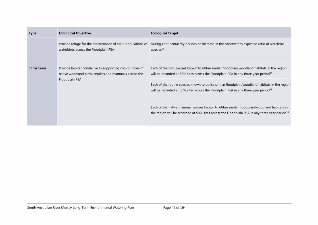
South Australian River Murray Long-Term Environmental Watering Plan Page 46 of 164
Type Ecological Objective Ecological Target
Provide refuge for the maintenance of adult populations of
waterbirds across the Floodplain PEA
During continental dry periods an increase in the observed to expected ratio of waterbird
species18
Other fauna Provide habitat conducive to supporting communities of
native woodland birds, reptiles and mammals across the
Floodplain PEA
Each of the bird species known to utilise similar floodplain woodland habitats in the region
will be recorded at 50% sites across the Floodplain PEA in any three year period18.
Each of the reptile species known to utilise similar floodplain/woodland habitats in the region
will be recorded at 50% sites across the Floodplain PEA in any three year period18.
Each of the native mammal species known to utilise similar floodplain/woodland habitats in
the region will be recorded at 50% sites across the Floodplain PEA in any three year period18.

South Australian River Murray Long-Term Environmental Watering Plan Page 47 of 164
Table 6. Environmental Water Requirements for the SA River Murray Floodplain Priority Environmental
Asset
Taken from Kilsby, et al. (2015)
EWR
#
Median
discharge
(ML/day
QSA)
Discharge
variability
(ML/day
QSA)
Duration
(days)
Preferred
timing
Average
return
frequency
(years)
Max
interval
(years)
Max rate
of water
level rise
(m/day)
Max rate
of water
level fall
(m/day)
FP1 50,000
45,000-
55,000 30 Sep-Dec 1.6 5 0.05 0.025
FP2 60,000
55,000-
65,000 30 Sep-Dec 2.0 5 0.05 0.025
FP3 70,000
65,000-
75,000 30 Sep-Dec 2.6 5 0.05 0.025
FP4 80,000
75,000-
85,000 30 Sep-Dec 3.6 5 0.05 0.025
FP5 80,000
75,000-
85,000 60 Sep-Dec 7.6 8 0.05 0.025
3.5 The Coorong, Lower Lakes and Murray Mouth Priority Environmental
Asset
3.5.1 Location and geographic extent
The Coorong, Lower Lakes and Murray Mouth Priority Environmental Asset (the 'CLLMM PEA') is equivalent to:
the Lower Lakes, Coorong and Murray Mouth TLM Icon Site (CLLMM Icon Site)
the Coorong, Lakes Alexandrina and Albert Ramsar Wetland of International Importance (Coorong and Lakes
Ramsar Site).
The CLLMM PEA and surrounding areas represent the central homelands of the Traditional owners, the
Ngarrindjeri, who have occupied, enjoyed, managed and used their inherited lands and waters within the area
since the Kaldowinyeri (Creation). This association is expressed through Kaldowinyeri stories (cultural and spiritual
histories) about Yarluwar-Ruwe (Sea Country) which reveals the significance of the relationship between the
country and the people, both practically and spiritually (See Ngarrindjeri Nation 2006). The whole CLLMM PEA is a
Ngarrindjeri cultural landscape.
The geomorphology, hydrology and water quality of the CLLMM PEA is extremely complex. The site is already
well described in a number of documents, particularly the Lower Lakes, Coorong and Murray Mouth
Environmental Water Management Plan (Murray-Darling Basin Authority, 2013b) and the Ecological Character
Description of the Coorong, Lakes Alexandrina and Albert Wetland of International Importance (Phillips, et al.,

South Australian River Murray Long-Term Environmental Watering Plan Page 48 of 164
2006), with a synopsis provided in O'Connor, et al. (2015). The following summary has been adapted from text
provided in these documents.
The CLLMM PEA covers a total approximate area of 142,530 hectares (Figure 9), and consists of four sub-regions:
1. the Lower Lakes - comprised of Lake Alexandrina (approximately 65,000 hectares) and Lake Albert
(approximately 23,000 hectares); both are large, shallow, permanent lakes surrounded by fringing, ephemeral
wetlands
2. the lower reaches of the Eastern Mount Lofty Ranges (EMLR) tributaries - the lower reaches of the tributaries
within the boundaries of the CLLMM PEA while the tributaries themselves are part of the EMLR Water
Resource Plan Area, which requires a separate LTWP
3. the Murray Mouth estuary - the area from the Goolwa Barrage to Pelican Point
4. the Coorong - a long (approximately 140 km), narrow (approximately 2 - 3 km), shallow lagoon, which is
separated into the North Lagoon and South Lagoon by a narrow constriction at Parnka Point.
Flows from upstream areas of the Murray-Darling Basin arrive via the Channel PEA and pass into Lake Alexandrina
(approximately 5 km south of Wellington) and out to the Southern Ocean via the Murray Mouth Estuary. Lake
Alexandrina also connects to the terminal Lake Albert by a small channel to its east. The Lower Lakes are
physically separated from the Murray Mouth and Coorong via a complex of islands, channels and five barrages.
The barrages were constructed in the 1930s to prevent ingress of saline water to the Lower Lakes and to regulate
lake water levels. Since 2002, five fishways have been incorporated into two barrages and an associated channel
to allow fish movement between freshwater and saline environments and up to seven additional fishways are
currently under construction (Rumbelow, 2015).
At times, small volumes of freshwater pass into Lake Alexandrina from the EMLR tributaries, which are fed by
unconfined aquifers and regional rainfall. When conditions are dry in the EMLR and there is no flow in the
tributaries, freshwater from Lake Alexandrina helps to maintain inundation of the wetlands in the lower reaches of
the EMLR tributaries, providing important habitat for birds, frogs and fish.
The salinity and morphology of the Murray Mouth estuary varies depending on freshwater flows and coastal
conditions and processes. Freshwater outflows are required to keep the Murray Mouth open. Due to the impacts
of River regulation and extraction, constriction and closure of the Murray Mouth has occurred in recent history,
with dredging required at times to maintain an open Murray Mouth.
The Coorong receives inflows at the northern end from Lake Alexandrina and the Southern Ocean, and at times to
the southern end via Salt Creek. It is a 'reverse estuary' (i.e. salinity increases with distance from the Mouth), with
salinities ranging from fresh to brackish in parts of the Murray Mouth estuary to hyper-saline in areas of the
South Lagoon. This gradient varies temporally depending on inflows from the Lower Lakes, Southern Ocean and
Salt Creek.
3.5.2 Conservation significance
The CLLMM PEA is recognised as a site of high ecological and cultural value through The Living Murray Initiative
and as a Wetland of International Importance under the Ramsar Convention. As the only estuary of the Murray-
Darling Basin, the CLLMM is also a unique geomorphological feature of the Basin.
Detailed descriptions of the conservation values of the CLLMM are provided in the Lower Lakes, Coorong and
Murray Mouth Environmental Water Management Plan (Murray-Darling Basin Authority, 2013b) and the
Ecological Character Description of the Coorong, Lakes Alexandrina and Albert Wetland of International

South Australian River Murray Long-Term Environmental Watering Plan Page 49 of 164
Importance (Phillips, et al., 2006). O'Connor, et al. (2015) provided the following summary of some of the key
values of the asset:
waterbirds: regularly supports >200,000 waterbirds during summer (Paton, 2010), significant numbers of
colonial-nesting and beach-nesting waterbirds (O'Connor, et al., 2013) and a number of threatened waterbird
species (Department of Environment, Water and Natural Resources, 2013b)
fish: play an important role for 49 native fish species, including diadromous, endangered and commercially
caught species (Phillips, et al., 2006; Ye, et al., 2014)
vegetation: characterised by a range of ecologically significant submerged, emergent and fringing vegetation
species and communities including, Gahnia sedgelands, Fleurieu Peninsula swamps and Ruppia tuberosa
(Phillips, et al., 2006).
Data from the DEWNR's biological database indicates that within the CLLMM PEA the following species of
conservation significance have been recorded at least once24:
34 plant species (Table 19 in Appendix 3) listed as Endangered, Vulnerable or Rare under the South
Australian National Parks and Wildlife Act 1972 ('state-listed')
93 protected fauna species (Table 20 in Appendix 3), of which 56 are state-listed species, two species are
listed as nationally threatened under the Environment Protection and Biodiversity Conservation Act 1999 (EPBC
Act), and six species are both state and nationally listed.
The significance of the CLLMM PEA is further indicated by the inclusion of three overall environmental objectives
within the Basin Plan that specifically relate to this asset, as follows:
s8.06 (3) An objective is to protect and restore connectivity within and between water-dependent ecosystems by
ensuring that:
(c) the Murray Mouth remains open at frequencies, for durations, and with passing flows, sufficient to
enable the conveyance of salt, nutrients and sediment from the Murray-Darling Basin to the ocean; and
(d) the Murray Mouth remains open at frequencies, and for durations, sufficient to ensure that the tidal
exchanges maintain the Coorong’s water quality (in particular salinity levels) within the tolerance of the
Coorong ecosystem’s resilience; and
Note: This is to ensure that water quality is maintained at a level that does not compromise the ecosystem
and that hydrologic connectivity is restored and maintained.
(e) the levels of the Lower Lakes are managed to ensure sufficient discharge to the Coorong and Murray
Mouth and help prevent river bank collapse and acidification of wetlands below Lock 1, and to avoid
acidification and allow connection between Lakes Alexandrina and Albert, by:
(i) maintaining levels above 0.4 metres Australian Height Datum for 95% of the time, as far as
practicable; and
(ii) maintaining levels above 0.0 metres Australian Height Datum all of the time
The CLLMM PEA also includes a significant ‘Sacred Site’ – the Meeting of the Waters’ (registered Aboriginal
heritage site under the SA Heritage Act 1988). This includes the waters and the bed of the lakes, river and estuary.
24 Presence/absence records from DEWNR's biological database have been provided as an indication of the number of threatened species that
have been found within each PEA only. Currently there are very few fish records and no invertebrate records entered into the dataset. This is not a
comprehensive list and does not reflect species records that have not been provided to DEWNR for input to the database.

South Australian River Murray Long-Term Environmental Watering Plan Page 50 of 164
Its spiritual and cultural significance is essential to the wellbeing and productivity of the Ngarrindjeri nation,
Ngarrindjeri lands and waters, and all living things (Ngarrindjeri Nation 2006).
3.5.3 Ecological attributes
A project was undertaken within DEWNR in 2015 (O'Connor, et al., 2015) that reviewed information from the
following key sources:
the existing objectives and targets for the CLLMM TLM Icon site (Maunsell Australia Pty Ltd, 2009; Murray-
Darling Basin Commission, 2006a) and a recent TLM condition monitoring refinement project (Robinson,
2014)
the critical components, processes and services (CPS), and limits of acceptable change (LAC) from the draft,
updated ecological character description (ECD) for the Coorong and Lakes Alexandrina and Albert Ramsar
site Coorong (Department of Environment Water and Natural Resources, in prep (a))
outputs from the MDBA's quantitative environmental outcomes workshops for shorebirds, general
waterbirds, Coorong fish and Ruppia tuberosa, and subsequent content in the BWEWS (Murray-Darling Basin
Authority, 2014e; Murray-Darling Basin Authority, 2014a).
This exercise indicates the following summary list of key ecological attributes for the CLLMM PEA:
ecosystem processes and physio-chemical conditions - hydrology, connectivity, salinity gradients, diversity
and extent of wetland types, Murray Mouth openness
vegetation – freshwater submergent and emergent communities, submergent and emergent halophytes,
Ruppia tuberosa
macroinvertebrates - taxonomic richness, distribution, biomass and sediment conditions
fish – diversity, diadromous species, endangered species, estuarine species, small-mouthed hardyhead
waterbirds - diversity, abundance, breeding, state and nationally threatened species, species listed under
international treaties and migratory agreements, 1% populations.
High-level conceptual models of the Lower Lakes and of the Coorong are provided in Maunsell Australia Pty Ltd
(2009). Hydro-ecological conceptual models of the likely response of vegetation, macroinvertebrates, fish and
waterbirds in the CLLMM under six discharges ranging from entitlement to 80,000 ML/day QSA are provided in
Bice, et al. (2014).
3.5.4 Ecological objectives, targets and environmental water requirements
In total, eight ecological objectives and 29 nested ecological targets have been identified for the CLLMM PEA
(Table 7 from O'Connor, et al. 2015)). The detailed methods for developing these objectives and targets are
described in O'Connor, et al. (2015). Seven of the eight ecological objectives are exact representations of TLM
‘targets’, as their content and wording was consistent with the definition of ‘ecological objectives' used in this
LTWP (refer Section 3.2). Two additional objectives relating to fish diversity and salinity were developed as they
were identified as a critical CPS but there was no corresponding TLM target. This ensured that all CPS and LAC25
described in the ECD have been represented by an ecological objective within the LTWP.
Four EWRs have been identified for the CLLMM PEA (Table 8 taken from O'Connor, et al. 2015). The EWRs for the
LTWP consider the EWRs described in Lester, et al. (2011) and Heneker (2010) that are needed to maintain
25 LAC are not equivalent to ecological objectives or targets, and instead represent thresholds that indicate a change in ecological character. Their
use in the development of ecological objectives in the LTWP was limited to ensuring that all relevant attributes of the asset had been incorporated

South Australian River Murray Long-Term Environmental Watering Plan Page 51 of 164
salinities of < 700 µS/cm and < 1000 µS/cm in Lake Alexandrina, but incorporate additional metrics to further
describe the desired hydrological regime for the site (O'Connor, et al., 2015).
The Coorong South Lagoon metrics were developed based on expert advice and represent the best available
information at the time of writing this plan. Further work analysing the interaction between volume, timing and
mouth openness would be beneficial. The metric represents target water levels and shows an incremental
increase when moving though the EWRs, with the water level for the lowest EWR (EWR-CLLMM1) indicating
target levels under low flow conditions. Under these conditions, strong Ruppia tuberosa recruitment events are
unlikely, however the target water level range will support the refuge population of Ruppia tuberosa within the
deeper channel, and is important for general mudflat health to support waterbird populations, including
migratory waders. This metric provides guidance for environmental water planning but should not preclude
targeting higher levels in real-time event planning should the opportunity arise for improved outcomes.
In total there are nine metrics for each of the EWRs, as follows:
1. Annual barrage flow - the minimum volume (gigalitres per year) released from the barrages (all gates) over
the course of a water-year. For some EWRs this should be calculated as a rolling average (i.e. average
volume over multiple years).
2. Average return interval - the desired average frequency that the minimum annual volume is released e.g. 1-
in-3 ARI means once every three years (or 33% of years) on average and does not seek to describe a regular
pattern.
3. Maximum interval - the maximum number of years between events that meet the EWR metrics.
4. Timing – barrage releases should occur over the entire water-year but the EWRs seek to vary the monthly
outflow volume with peaks outflows in late spring/early summer in order to support seasonal ecological
processes. This variation is described in
5. Figure 10.
6. Lake water level range - the range that Lake water levels should remain within throughout the year (in
mAHD); water level values should be calculated as the average across the Lower Lakes rather than a
minimum or maximum at any given location.
7. Lake water level timing - describes the months when maximum and minimum water levels should occur.
8. Coorong South Lagoon water level - the range that water levels (in mAHD) should remain within at the
indicated time. This should be based on the minimum water level at any given point rather than an average
across multiple locations.
9. Coorong South Lagoon water level timing - the months when South Lagoon water levels need to remain
within the specified range.
10. Coorong South Lagoon duration - the number of days that South Lagoon water levels need to remain within
the specified range.

South Australian River Murray Long-Term Environmental Watering Plan Page 52 of 164
Figure 9. Spatial extent of the Coorong, Lower Lakes and Murray Mouth Priority Environmental Asset

South Australian River Murray Long-Term Environmental Watering Plan Page 53 of 164
Figure 10. Hypothetical optimal timing of barrage releases for various annual flow scenarios
(Developed by J. Higham, CLLMM Recovery Project)

South Australian River Murray Long-Term Environmental Watering Plan Page 54 of 164
Table 7. Ecological objectives and targets for the Coorong, Lower Lakes and Murray Mouth Priority Environmental Asset
Table taken from O'Connor, et al. (2015). Note, additional target detail and supplementary information, and the source reference for the target information have not been
transferred into this long-term plan and should be sourced from Table 1 in the original document
Type Ecological objective Ecological targets
Waterbirds Maintain or improve waterbird populations in the
Coorong and Lower Lakes
Abundances, area of occupation and extent of occurrence of TLM target waterbird species
(Table 21 in Appendix 4) to be above defined median reference values (median of data from the
15 years between 2000 and 2014) (Paton, 2014a)
Detect annual breeding activity in waterbird species that are expected to breed annually at the
site (Table 22 Error! Reference source not found.in Appendix 4) and at least two breeding
events in any four consecutive years in species that breed regularly at the site (Table 23 in
Appendix 4) (Department of Environment Water and Natural Resources, in prep (a))
Provide functional mudflat habitat to sustain active shorebird foraging behaviour during
November-March with a foraging effort of <50%. (Murray-Darling Basin Authority, 2014e)
Maintain abundances of 12 waterbird species (Table 24 in Appendix 4) at or above 1% of the
total flyway population size (Department of Environment Water and Natural Resources, in prep
(a))
Fish Maintain a spatio-temporally diverse fish community
and resilient populations of key native fish species in
the lower lakes and Coorong
A spatio-temporally diverse fish community is present including all 23 fish families stated in the
Ramsar site draft Ecological Character Description (Table 25 in Appendix 4) (Department of
Environment Water and Natural Resources, in prep (a))
Annual detection of juvenile Catadromous fish at abundances ≥ that of defined ‘Recruitment
Index’ values (44.5 for Congolli, and 6.1 for Common galaxias) (Bice, et al., 2014)

South Australian River Murray Long-Term Environmental Watering Plan Page 55 of 164
Annual detection of migration for Anadromous species (short-headed and pouched lamprey) at
index values of >0.6 (Bice, et al., 2014)
Maximise fish passage connectivity between the Lower Lakes and Coorong, and between the
Coorong and the sea by allowing fishways to operate year-round (Murray-Darling Basin
Authority, 2013b)
Maintain or improve abundances of Murray hardyheads and pygmy perch so that ‘Relative
Abundance Index’ values of ≥1 are achieved on an annual basis (Wedderburn, 2014)
Detect recruitment success of Murray hardyheads and pygmy perch at least every second year
(Wedderburn, 2014)
Maintain or improve abundances, distribution and recruitment of black bream and greenback
flounder with population condition score ≥3 (Ye, et al., 2014a)
Facilitate regular recruitment and a broader distribution of juvenile mulloway (Ye, et al., 2014a)
Maintain an average Catch-Per-Unit-Effort (CPUE) of small-mouthed hardyhead sampled in
spring/early summer of > 120 for adults, and >790 for juveniles (Ye, et al., 2014b)
Maintain the proportional abundance of small-mouthed hardyhead juveniles at >60% in 75% of
defined monitoring sites within the CLLMM (Ye, et al., 2014b)
Macroinvertebrates Maintain or improve invertebrate communities in
estuarine and lagoon sediments
Macroinvertebrate taxonomic distinctness falls within the expected ranges of a regional
reference (Dittman, 2014)
The distribution of macroinvertebrate species remains within or above the species-specific
reference level for their index of occurrence (Dittman, 2014)

South Australian River Murray Long-Term Environmental Watering Plan Page 56 of 164
The area of occupancy where abundance and biomass are at or above the reference level
should be >20% of the monitoring sites (Dittman, 2014)
The macroinvertebrate community has a higher multivariate similarity to the community
present in years with flow than without flow (Dittman, 2014)
Maintain habitable sediment conditions in mudflats Median grain size of sediments in the Coorong and Murray Mouth will remain between 125 –
500 μm (Dittman, 2014)
Sediment organic matter content between 1 and 3.5 % dry weight in the Coorong and Murray
Mouth (Dittman, 2014)
Vegetation Restore Ruppia tuberosa colonisation and
reproduction in the Coorong at a regional and local
scale
A continuous distribution of Ruppia tuberosa beds along a 50 km section of the southern
Coorong (excluding outliers) (Paton, 2014b)
Within the abovementioned distribution, 80% of the monitored sites should have Ruppia
tuberosa plants present in winter and summer (Paton, 2014b)
50% of sites with Ruppia tuberosa to exceed the local site indicators for a healthy Ruppia
tuberosa population (Paton, 2014b)
Support a resilient Ruppia tuberosa population with seed densities of 2000 seeds/m2 by 2019
and 50% of sites having 60% cover in winter and a seed bank of 10,000 seeds/m2 by 2029 in the
Coorong South Lagoon (Paton, 2014b)
Maintain or improve aquatic and littoral vegetation in
the Lower Lakes
Maintain or improve diversity of aquatic and littoral vegetation in the Lower Lakes as quantified
using the LLCMM vegetation indices (Nicol, et al., 2014b)

South Australian River Murray Long-Term Environmental Watering Plan Page 57 of 164
Water quality Establish and maintain stable salinities in the lakes
and a variable salinity regime in the Murray estuary
and Coorong.
Barrage outflows sufficient to maintain electrical conductivity in Lake Alexandrina at a long term
average of 700 μS/cm, below 1,000 μS/cm 95% of years and below 1,500 μS/cm 100% of the
time (Heneker, 2010)
To support aquatic habitat: maintain a salinity gradient from 0.5 ppt to 35ppt between the
Barrages and Murray Estuary area, <45ppt in the North lagoon, and from 60ppt to 100 ppt in
the South lagoon (Lester, et al., 2011)
Ecosystem
processes
Maintain a permanent Murray Mouth opening
through freshwater outflows with adequate tidal
variations to improve water quality and maximise
connectivity between the Coorong and the sea
Maintain an open Murray Mouth, as indicated when the Diurnal Tidal Ratio (DTR) at Goolwa
exceeds 0.3, with minimum DTR values of 0.05 and 0.2 at Tauwitchere and Goolwa respectively
(Murray-Darling Basin Authority, 2013b; Department of Water Land and Biodiversity
Conservation, 2008)
Maintain a minimum annual flow required to keep the Murray Mouth open (730—1,090
GL/year) (Murray-Darling Basin Authority, 2013b)

South Australian River Murray Long-Term Environmental Watering Plan Page 58 of 164
Table 8. Environmental Water Requirements for the Coorong, Lower Lakes and Murray Mouth Priority Environmental Asset
Table taken from O'Connor, et al. (2015). ‘Timing’ of barrage flows, lake levels and Coorong South Lagoon water levels include the entire duration of each month specified
(i.e. from the beginning of the first month to the end of the final month).
26 A total average barrage outflow of 2,000 GL/year over a three year rolling period (i.e. not less than 6,000 GL over three years) and not less than 650 GL/year in any one of the three years (Heneker 2010; Lester et al. 2011) 27 A total average barrage outflow of 4,000 GL/year over a three year rolling period (i.e. not less than 12,000 GL over three years) and not less than 3150 GL/year in any one of the three years (Heneker 2010; Lester et al. 2011)
EWR #
Average
return
interval
(years)
Maximum
interval
(years)
Annual
barrage
flow
(GL/year)
Barrage flow
timing
Lakes water
level range
(mAHD)
Lakes water level
timing
Coorong
south
lagoon
water level
(mAHD)
Coorong
south lagoon
water level
timing
Coorong
south lagoon
duration
(days)
CLLMM1 1-in-1 N/A >65026
Jul-Jun, with peak
barrage outflows
in Oct-Dec
0.4-0.75
Maximum lake levels
Dec-Feb and minimum
lake levels in Mar-May
0.0 to 0.2 Sept-Nov ≥90
-0.2 to -0.4 Feb-Mar -
CLLMM2 1-in-2 N/A >315027
Jul-Jun, with peak
barrage outflows
in Oct-Dec
0.4-0.83
Maximum lake levels
Dec-Feb and minimum
lake levels in Mar-May
0.35-0.45 Sept-Dec ≥120
0 to -0.5 Mar-April -
CLLMM3 1-in-3 5 >6,000
Jul-Jun, with peak
barrage outflows
in Oct-Dec
0.4-0.83
Maximum lake levels
Dec-Feb and minimum
lake levels in Mar-May
0.35-0.45 Sept-Jan ≥150
0 to -0.5 Feb-April -
CLLMM4 1-in-7 17 >10,000
Jul-Jun, with peak
barrage outflows
in Oct-Dec
0.4-0.9
Maximum lake levels
Dec-Feb and minimum
lake levels in Mar-May
0.35-0.45 Sept-end Feb ≥180
n/a n/a -

South Australian River Murray Long-Term Environmental Watering Plan Page 59 of 164
3.6 Application of the environmental water requirements
3.6.1 EWRs contribution to targets
The methods used to develop the EWRs for this LTWP do not provide a single EWR per objective or target; rather,
the suite of EWRs for each PEA describes a variable flow regime which is required to achieve the ecological
targets. To assist with annual planning and environmental watering decisions, such as potential benefits or trade-
offs under different flow scenarios, a matrix was developed that assessed the likely contribution of each EWR in
isolation towards achieving each of the ecological targets. The assessment uses a coarse ranking system and so a
result of no change in ranking does not necessarily mean there is no improvement in contribution, and outcomes
will be dependent on antecedent flows and prevailing ecosystem condition (Wallace, et al., 2014a). The matrices
were populated based on the flow-ecology conceptual models (see PEA descriptions above) and expert opinion,
and the results are presented in the three tables below:
Table 9. Assessment of contribution of SA River Murray Channel Priority Environmental Asset EWRs towards
Ecological Targets
Table 10. Assessment of contribution of SA River Murray Floodplain Priority Environmental Asset EWRs
towards Ecological Targets
Table 11. Assessment of contribution of Coorong, Lower Lakes and Murray Mouth Priority Environmental
Asset EWRs towards Ecological Targets.
The matrices developed for the Floodplain PEA and the CLLMM PEA show the importance of irregular flows of
70,000 ML/day QSA or greater in achieving ecological outcomes, with the higher EWRs likely to result in a 'large
positive contribution' to the greatest number of targets. However, the need for a long-term variable flow regime
consisting of baseflows, in-channel freshes and overbank flows (as represented by the suite of EWRs for each
asset) should not be overlooked.
3.6.2 EWRs and annual planning
The EWRs for the priority environmental assets are not presented in the form of prescriptive five-year
hydrographs because the feasibility of delivery will be highly dependent on climatic conditions. In order to meet
the majority of the EWRs, environmental water will need to be delivered in conjunction with unregulated flows, as
the volume of water required is greater than that provided by South Australia's Entitlement or available to the
environment through water recovery programmes. The need to deliver an EWR in any given year will also depend
on antecedent climate conditions and the condition of the different ecological components of the asset.
Therefore the EWRs describe a desired long-term and variable hydrological regime in a way that enables flexibility
and adaptive management in response to climate and ecological condition.
In recent years, South Australia has used a scenario-based approach to plan and prioritise environmental watering
actions each year. The process is described in the Annual Environmental Watering Plans for the South Australian
River Murray, which are published on the DEWNR website. The EWRs can be used to inform annual planning by:
comparing desired return frequency (i.e. the average return frequency metric of EWR) to actual return
frequency (i.e. how often the EWR has been met based on surface water data) over a 20-year period, where
an EWR is considered to be met within any given water-year when the volume/discharge, duration, timing,
water level and rate of change metrics have all been satisfied. A 20-year timeframe is used as it captures the
longest ‘maximum interval’ specified by any of the EWRs (i.e. 17 years for EWR - CLLMM4) and ensures results
are based on long-term watering histories
assessing the number of years since the EWR was met and comparing to the maximum interval metric of the
EWR.

South Australian River Murray Long-Term Environmental Watering Plan Page 60 of 164
These assessments are hydrological and assume the flow-ecology relationship is well understood. Decisions
should also be informed by results from ecological monitoring that indicate current condition, need for water and
risk of not watering. Once accurate forecasts of climatic conditions are available then the assessment should be
revisited and watering actions refined based on what is feasible to deliver.
In addition to the ecological information, management considerations within Section 4 should also be taken into
account during planning and decision-making, including:
Indigenous values – consideration of, and where possible alignment with, Indigenous values in order to
maximise the benefits from environmental watering
cooperative arrangements – processes to be followed to ensure that watering actions across the WRP Area
and SCB are coordinated, and potential risks to water quality are considered
operational constraints – whether it is feasible to deliver the proposed watering action in view of operational
constraints
long-term risks to providing environmental water – whether the proposed watering action addresses any of
the potential long-term risks.
3.6.3 EWRs and management levers
The description of landscape-scale environmental assets for the SA River Murray LTWP and their EWRs
encourages the reinstatement of a more natural flow regime through the delivery of environmental water to the
South Australian border, and subsequently downstream to the CLLMM. To meet most EWRs will require an
unregulated flow event to occur, with environmental water used to boost the magnitude or duration of the event.
However, the PEAs incorporate many smaller scale management units that offer alternative opportunities for
delivering environmental water and meeting the EWR metrics in discrete locations. In particular, the Chowilla
Environmental Regulator and the main channel weirs can be raised to increase the extent of inundation of parts
of the Channel and Floodplain PEAs, while pumps can be used to deliver water to discrete temporary wetland
basins in any of the three PEAs. Each of these management units have their own management plans and site-
specific objectives and targets, but these types of actions will also contribute to partially meeting the ecological
targets of the PEAs. The mechanism for evaluating the contribution of localised environmental water delivery to
the PEA ecological targets will be addressed through the development of a separate integrated monitoring and
evaluation plan, and the information used to inform adaptive management of both the site and the PEA.
Conversely, the discrete management sites that are likely to receive water as a result of enhancing flows at the
South Australian border can be identified. Appendix 5 provides a table of the modelled flow rates when
inundation of selected28 temporary wetlands begins (commence-to-flow), which has been developed by staff
within the Natural Resources SA MDB branch of DEWNR (Turner, 2015). Natural Resources SA MDB staff are
developing a floodplain wetland management plan which presents this information, as well as the management
objectives and desired return frequency of inundation events (based on commence-to-flow levels and modelled
natural hydrological regimes). Cross-referencing the wetland commence-to-flow values and the discharge metrics
of the EWRs for the Channel PEA and the Floodplain PEA provides an indication of which of the managed
temporary wetlands is influenced by the delivery of different flow events, noting that this relationship will change
in lock reaches where weir manipulations or operation of large environmental regulators are undertaken.
28 Temporary wetlands listed are those that have previously been inundated through pumping or have been identified as potential pump sites - it
does not represent all temporary wetlands on the SA River Murray floodplain. This list is likely to change in the future.

South Australian River Murray Long-Term Environmental Watering Plan Page 61 of 164
Fringing temporary wetlands of the CLLMM PEA are influenced by water levels in the Lower Lakes (which are
largely influenced by barrage operations) and the effects of wind seiching, and their desired hydrological regime
is provided by the variable Lake levels specified in the CLLMM PEA EWRs. Pumping water to these wetlands may
be required at times, depending on climatic conditions and the ability to maintain the appropriate seasonal Lake
level pattern.
The Channel PEA also includes a large number of pool-connected wetlands; that is wetlands that are permanently
inundated due to the stable water levels created by the weirs. At some of these wetlands, wetting and drying
regimes have been reinstated through the installation of infrastructure that enables them to be disconnected
from the River. These managed pool-connected wetlands have their own management plans that describe site-
specific objectives and targets. The unmanaged and the managed pool-connected wetlands use planned
environmental water and held environmental water, respectively. It may be difficult to determine the direct
contribution that pool-connected wetlands make to the Channel PEAs ecological targets, which focus largely on
outcomes from the delivery of additional water to South Australia. However, increased flows and the re-
establishment of lotic habitats in the main channel will increase the value of the lentic conditions provided by off-
channel habitats.
South Australian River Murray Long-Term Environmental Watering Plan Page 62 of 164
Table 9. Assessment of contribution of SA River Murray Channel Priority Environmental Asset EWRs towards Ecological Targets
Table taken from Wallace, et al. (2014a)
Assessment based on the following ranking system:
Score Requirements or processes met Contribution towards Ecological Targets
1 All or most Large positive contribution
2 Some Moderate positive contribution
3 Very few or none Contribution unlikely to be detectable or expected
Channel Ecological Target EF29
Channel EWR30
IC1
(1
0,0
00
)
IC2
(1
5,0
00
)
IC3
(2
0,0
00
)
IC4
(2
5,0
00
)
IC5
(3
0,0
00
)
IC6
(3
5,0
00
)
IC7
(4
0,0
00
)
Open-water productivity shows a temporary shift from near zero or autotrophic dominance (positive
Net Daily Metabolism) towards heterotrophy (negative Net Daily Metabolism) when QSA >30,000
ML/day.
3 3 3 3 2 2 1 1
Habitat across the range of velocity classes is present in the lower third of weir pools for at least 60
consecutive days in Sep–Mar, at a maximum interval of 2 years. 3 3 3 2 1 1 1 1
29 EF = entitlement flow and is provided as a comparison only 30 Refer Table 4 for full description of Channel EWRs. The discharge magnitude has been provided (in brackets) to assist with cross-referencing, however the EWR consists of several metrics including duration, return frequency
and timing.

South Australian River Murray Long-Term Environmental Watering Plan Page 63 of 164
Channel Ecological Target EF29
Channel EWR30
IC1
(1
0,0
00
)
IC2
(1
5,0
00
)
IC3
(2
0,0
00
)
IC4
(2
5,0
00
)
IC5
(3
0,0
00
)
IC6
(3
5,0
00
)
IC7
(4
0,0
00
)
Thermal stratification does not persist for more than 5 days at any time. 3 1 1 1 1 1 1 1
Basin Plan Objective: Salt export, averaged over the preceding 3 years, is ≥2 million tonnes per year. 3 3 2 2 2 1 1 1
Inundation periods in temporary wetlands have unrestricted lateral connectivity between the river and
wetlands in >90% of inundation events. 3 3 3 3 2 2 2 1
Biovolume <4 mm3/L for all Cyanobacteria, where a known toxin producer is dominant, or <10 mm3/L
for all Cyanobacteria where toxins are not present. 3 2 1 1 1 1 1 1
Basin Plan Target: Maintain dissolved oxygen above 50% saturation throughout water column at all
times. 3 3 3 2 2 2 1 1
Establish and maintain freshwater lenses in near-bank recharge zones. 3 3 2 2 2 2 1 1
Maintain soil water availability, measured as soil water potential > -1.5 MPa at soil depth 20–50 cm, to
sustain recruitment of long-lived vegetation across the elevation gradient in the target zone. 3 3 3 2 2 2 2 1
Reduce soil salinity (measured as EC 1:5) to <5000 μS/cm to prevent shifts in understorey plant
communities to salt-tolerant functional groups across the elevation gradient in the target zone. 3 3 3 2 2 2 2 1
Median biofilm composition is not dominated (>80%) by filamentous algae. 3 2 2 2 1 1 1 1

South Australian River Murray Long-Term Environmental Watering Plan Page 64 of 164
Channel Ecological Target EF29
Channel EWR30
IC1
(1
0,0
00
)
IC2
(1
5,0
00
)
IC3
(2
0,0
00
)
IC4
(2
5,0
00
)
IC5
(3
0,0
00
)
IC6
(3
5,0
00
)
IC7
(4
0,0
00
)
Median biofilm C:N ratios are <10:1. 3 2 2 2 1 1 1 1
In standardised transects spanning the elevation gradient in the target zone, 70% of river red gums have
a Tree Condition Index score ≥ 10. 3 3 2 2 2 2 2 1
A sustainable demographic is established to match the modelled profile for a viable river red gum
population in existing communities spanning the elevation gradient in the target zone. 3 3 3 2 2 2 2 1
Species from the Plant Functional Group ‘flood-dependent/responsive’ occur in 70% of quadrats
spanning the elevation gradient in the target zone at least once every 3 years. 3 3 3 2 2 2 2 1
Native macrophytes from the emergent, amphibious and flood- dependent functional groups occur in
70% of quadrats spanning the elevation gradient in the target zone at least once every 3 years. 3 3 3 3 2 2 2 1
Expected fish species occur in each mesohabitat (channel, anabranch, wetlands) in each weir pool/reach. 3 3 3 3 3 2 1 1
Population age structure of Murray cod includes recent recruits, sub-adults and adults in 9 years in 10. 3 3 3 2 2 2 2 2
Population age structure of Murray cod indicates a large recruitment event 1 year in 5, demonstrated by
a cohort representing >50% of the population. 3 3 3 3 3 3 3 2
Abundance (CPUE) of Murray cod increases by ≥50% over a 10-year period. 3 3 3 2 2 2 2 2

South Australian River Murray Long-Term Environmental Watering Plan Page 65 of 164
Channel Ecological Target EF29
Channel EWR30
IC1
(1
0,0
00
)
IC2
(1
5,0
00
)
IC3
(2
0,0
00
)
IC4
(2
5,0
00
)
IC5
(3
0,0
00
)
IC6
(3
5,0
00
)
IC7
(4
0,0
00
)
Population age structure of golden perch and silver perch includes YOY with sub-adults and adults in 8
years in 10. 3 3 2 2 2 2 2 1
Population age structure of golden perch and silver perch indicates a large recruitment event 2 years in
5, demonstrated by separate cohorts representing >30% of the population. 3 3 2 2 2 2 2 1
Abundance (CPUE) of golden perch and silver perch increases by ≥30% over a 5-year period. 3 3 3 2 2 2 2 1
Population age structure of freshwater catfish includes YOY, with sub-adults and adults in 9 years in 10. 3 3 3 2 2 2 2 1
Population age structure of freshwater catfish indicates a large recruitment event 2 years in 5,
demonstrated by separate cohorts representing >30% of the population. 3 3 3 3 3 2 2 1
Abundance (CPUE) of freshwater catfish increases by ≥30% over a 5-year period. 3 3 3 3 3 2 2 1
Length-frequency distributions for foraging generalists include size classes showing annual recruitment. 1 1 1 2 2 2 2 2
Relative abundance and biomass of common carp do not increase in the absence of increases in
abundance and biomass of flow-dependent native fish. 1 1 2 2 2 1 1 1

South Australian River Murray Long-Term Environmental Watering Plan Page 66 of 164
Table 10. Assessment of contribution of SA River Murray Floodplain Priority Environmental Asset EWRs towards Ecological Targets
Table taken from Kilsby, et al. (2015)
Assessment based on the following ranking system:
Score Requirements or processes met Contribution towards Ecological Targets
1 All or most Large positive contribution
2 Some Moderate positive contribution
3 Very few or none Contribution unlikely to be detectable or expected
Floodplain Ecological targets
Floodplain EWR31
FP
1 (
50,0
00)
FP
2 (
60,0
00)
FP
3 (
70,0
00)
FP
4 (
80,0
00;
30-d
ays)
FP
5 (
80,0
00;
60-d
ays)
During inundation periods, record an increase in the abundance and diversity of invertebrate food resources, nutrients and
DOC relative to those available during base flow 2 1 1 1 1
Deliver flows in a manner that reduces the proportion of slow flowing habitat and increases the proportion of moderate
velocity habitat thereby reinstating a diversity of velocity classes representative of natural conditions 1 1 1 1 1
Discharge, water level and duration metrics of planned e-water represent a seasonally variable hydrograph 1 1 1 1 1
31 Refer Table 6 for full description of Floodplain EWRs. The discharge magnitude has been provided (in brackets) to assist with cross-referencing, however the EWR consists of several metrics including duration, return
frequency and timing.

South Australian River Murray Long-Term Environmental Watering Plan Page 67 of 164
Floodplain Ecological targets
Floodplain EWR31
FP
1 (
50,0
00)
FP
2 (
60,0
00)
FP
3 (
70,0
00)
FP
4 (
80,0
00;
30-d
ays)
FP
5 (
80,0
00;
60-d
ays)
Maintain dissolved oxygen above 50% saturation throughout water column at all times, in connected waters 1 1 1 1 1
Establish and maintain freshwater lenses in near-bank recharge zones 2 1 1 1 1
Maintain soil water availability, measured as soil water potential at soil depth 20-50cm, greater than -1.5 MPa in order to
sustain the recruitment of long-lived vegetation 2 2 1 1 1
Reduce soil salinity (EC 1:5) to below 5000 µS/cm to prevent permanent shifts in understorey plant communities to salt
tolerant functional groups 2 2 1 1 1
Maintain soil sodicity below the exchangeable sodium percent (ESP) value of 15 (highly sodic) 2 2 1 1 1
Limit the maximum rate of drawdown (averaged over 3 consecutive days) to ≤0.025 m/day (0.05m/day in any one day) to
minimise risk of bank failure 1 1 1 1 1
In standardised transects that span the Floodplain PEA elevation gradient and existing spatial distribution >70% of all River
red gum trees have a TCI ≥10 3 3 2 1 1
A sustainable demographic that matches the modelled profile for a viable River red gum population is established within
existing communities across the floodplain elevation gradient 3 3 3 2 1
In standardised transects that span the Floodplain PEA elevation gradient and existing spatial distribution, >70% of all black
box trees have a TCI ≥10 3 3 2 2 1

South Australian River Murray Long-Term Environmental Watering Plan Page 68 of 164
Floodplain Ecological targets
Floodplain EWR31
FP
1 (
50,0
00)
FP
2 (
60,0
00)
FP
3 (
70,0
00)
FP
4 (
80,0
00;
30-d
ays)
FP
5 (
80,0
00;
60-d
ays)
A sustainable demographic that matches the modelled profile for a viable black box population is established within existing
communities across the floodplain elevation gradient 3 3 3 2 1
In standardised transects that span the Floodplain PEA elevation gradient and existing spatial distribution, >70% of all River
cooba trees have a TCI ≥10 3 3 2 1 1
A sustainable demographic that matches the modelled profile for a viable River cooba population is established within
existing communities across the floodplain elevation gradient 3 3 3 2 1
In standardised transects that span the floodplain elevation gradient and existing spatial distribution , ≥70% of Lignum plants
have a LCI ≥6 for colour 3 3 3 1 1
In aquatic zones, a minimum of 40% of cells either inundated or dry containing inundation- dependent or amphibious plant
taxa once every two years on average with maximum interval no greater than 4 years. Native water dependent species
richness >30 across the Floodplain PEA.
3 2 1 1 1
In aquatic zones, a minimum of 80% of cells either inundated or dry containing native flood dependent or amphibious plant
taxa once every four years on average with maximum interval no greater than 6 years. Native water dependent species
richness >50 across the Floodplain PEA.
3 3 2 1 1
In shedding floodplain zones, a minimum of 20% of cells containing native flood dependent or amphibious plant taxa once
every three years on average with maximum interval no greater than 5 years. Native flood dependent and amphibious species
richness >20 across the Floodplain PEA.
2 2 1 1 1

South Australian River Murray Long-Term Environmental Watering Plan Page 69 of 164
Floodplain Ecological targets
Floodplain EWR31
FP
1 (
50,0
00)
FP
2 (
60,0
00)
FP
3 (
70,0
00)
FP
4 (
80,0
00;
30-d
ays)
FP
5 (
80,0
00;
60-d
ays)
In shedding floodplain zones, of 40% of cells containing native flood dependent or amphibious plant taxa once every five
years on average with maximum interval no greater than 7 years. Native flood dependent and amphibious species richness
>30 across the Floodplain PEA.
3 2 1 1 1
In shedding floodplain zones, of 65% of cells containing native flood dependent or amphibious plant taxa once every seven
years on average with maximum interval no greater than 10 years. Native flood dependent and amphibious species richness
>50 across the Floodplain PEA.
3 3 2 1 1
Population age structure of Murray cod includes recent recruits, sub-adults and adults in 9 years in 10. 2 2 1 1 1
Population age structure of Murray cod indicates a large recruitment event 1 year in 5, demonstrated by a cohort
representing >50% of the population. 2 2 1 1 1
Abundance (CPUE) of Murray cod increases by ≥50% over a 10-year period. 2 2 1 1 1
Population age structure of Freshwater catfish includes YOY, with sub-adults and adults in 9 years in 10. 2 2 1 1 1
Population age structure of Freshwater catfish indicates a large recruitment event 2 years in 5, demonstrated by separate
cohorts representing >30% of the population. 2 2 2 1 1
Abundance (CPUE) of Freshwater catfish increases by ≥30% over a 5-year period. 2 2 2 1 1
Population age structure of Golden perch and Silver perch includes YOY with sub-adults and adults in 8 years in 10. 1 1 1 1 1

South Australian River Murray Long-Term Environmental Watering Plan Page 70 of 164
Floodplain Ecological targets
Floodplain EWR31
FP
1 (
50,0
00)
FP
2 (
60,0
00)
FP
3 (
70,0
00)
FP
4 (
80,0
00;
30-d
ays)
FP
5 (
80,0
00;
60-d
ays)
Population age structure of Golden perch and Silver perch indicates a large recruitment event 2 years in 5, demonstrated by
separate cohorts representing >30% of the population. 1 1 1 1 1
Abundance (CPUE) of Golden perch and Silver perch increases by ≥30% over a 5-year period. 1 1 1 1 1
The length-frequency distributions for wetland/floodplain (native fish) specialists within aquatic zones across the Floodplain
PEA include size classes showing annual recruitment. 3 3 2 1 1
Increase range and abundance of wetland/floodplain (native fish) specialists within aquatic zones across the Floodplain PEA 3 3 2 1 1
The relative abundance and biomass of non-native species does not increase in the absence of increases in abundance and
biomass of native fish. 2 2 1 1 1
Each of eight riparian frog species present within the Floodplain PEA will be recorded across the floodplain in any three year
period. 2 1 1 1 1
Tadpoles will be recorded from eight species in later stages of metamorphosis across the Floodplain PEA in any three year
period. 2 2 1 1 1
Minimum inundation periods required for successful breeding by a range of water bird species are provided. Preliminary
minimum 120 days. 3 3 2 1 1
During continental dry periods an increase in the observed to expected ratio of waterbirds 2 2 1 1 1

South Australian River Murray Long-Term Environmental Watering Plan Page 71 of 164
Floodplain Ecological targets
Floodplain EWR31
FP
1 (
50,0
00)
FP
2 (
60,0
00)
FP
3 (
70,0
00)
FP
4 (
80,0
00;
30-d
ays)
FP
5 (
80,0
00;
60-d
ays)
Each of the bird species known to utilise similar floodplain woodland habitats in the region will be recorded at 50% sites
across the Floodplain PEA in any three year period. 3 3 3 2 1
Each of the reptile species known to utilise similar floodplain/woodland habitats in the region will be recorded at 50% sites
across the Floodplain PEA in any three year period. 3 3 3 2 1
Each of the native mammal species known to utilise similar floodplain/woodland habitats in the region will be recorded at
50% sites across the Floodplain PEA in any three year period. 3 3 3 2 1
South Australian River Murray Long-Term Environmental Watering Plan Page 72 of 164
Table 11. Assessment of contribution of Coorong, Lower Lakes and Murray Mouth Priority Environmental Asset EWRs towards Ecological Targets
Table taken from O'Connor, et al. (2015)
Assessment based on the following ranking system:
Score Requirements or processes met Contribution towards Ecological Targets
1 All or most Large positive contribution
2 Some Moderate positive contribution
3 Very few or none Contribution unlikely to be detectable or expected
CLLMM Ecological Targets Species or
wetland
CLLMM EWRs32
CLLM
M1
(>6
50
)
CLLM
M2
(>3
,15
0)
CLLM
M3
(>6
,00
0)
CLLM
M4
(>1
0,0
00
)
Abundances, area of occupation, and extent of occurrence of TLM target waterbird species to be above
defined median reference values (median of data from the 15 years between 2000 and 2014) n/a 3 2 1 1
Detect annual breeding activity in waterbird species that are expected to breed annually at the site and at
least two breeding events in any four consecutive years in species that breed regularly at the site
n/a 3 2 1 1
Provide functional mudflat habitat to sustain active shorebird foraging behaviour during November-
March with a foraging effort of <50%
n/a 3 2 1 1
32 Refer Table 8 for full description of CLLMM EWRs. The annual barrage outflow volume has been provided (in brackets) to assist with cross-referencing, however the EWR consists of several metrics including water levels,
duration, return frequency and timing.

South Australian River Murray Long-Term Environmental Watering Plan Page 73 of 164
CLLMM Ecological Targets Species or
wetland
CLLMM EWRs32
CLLM
M1
(>6
50
)
CLLM
M2
(>3
,15
0)
CLLM
M3
(>6
,00
0)
CLLM
M4
(>1
0,0
00
)
Maintain abundances of 12 waterbird species at or above 1% of the total flyway population size n/a 3 2 1 1
A spatio-temporally diverse fish community is present including all 23 fish families stated in the Ramsar
site draft Ecological Character Description
n/a
2 2 1 1
Annual detection of juvenile Catadromous fish at abundances ≥ that of defined ‘Recruitment Index’ values
(44.5 for Congolli, and 6.1 for Common galaxias.
n/a
2 1 1 1
Annual detection of migration for Anadromous species (short-headed and pouched lamprey) at index
values of >0.6.
n/a 3 2 1 1
Maximise fish passage connectivity between the Lower Lakes and Coorong, and between the Coorong
and the sea by allowing fishways to operate year-round n/a 2 1 1 1
Maintain or improve abundances of Murray hardyheads and pygmy perch so that ‘Relative Abundance
Index’ values of ≥1 are achieved on an annual basis
Murray
hardyhead 1 2 2 2
Yarra pygmy
perch 2 1 1 1

South Australian River Murray Long-Term Environmental Watering Plan Page 74 of 164
CLLMM Ecological Targets Species or
wetland
CLLMM EWRs32
CLLM
M1
(>6
50
)
CLLM
M2
(>3
,15
0)
CLLM
M3
(>6
,00
0)
CLLM
M4
(>1
0,0
00
)
Detect recruitment success of Murray hardyheads and pygmy perch at least every second year
Murray
hardyhead 1 2 2 2
Yarra pygmy
perch 1 1 1 1
Maintain or improve abundances, distribution and recruitment of black bream and greenback flounder
with population condition score ≥3.
Black bream 2 2 1 1
Greenback
flounder 3 2 1 1
Facilitate regular recruitment and a broader distribution of juvenile mulloway n/a
3 2 1 1
Maintain an average Catch-Per-Unit-Effort (CPUE) of small-mouthed hardyhead sampled in spring/early
summer of > 120 for adults, and >790 for juveniles
n/a 3 2 1 1
Maintain the proportional abundance of small-mouthed hardyhead juveniles at >60% in 75% of defined
monitoring sites within the CLLMM
n/a
2 1 1 1
Macroinvertebrate taxonomic distinctness falls within the expected ranges of a regional reference.
Lower Lakes 2 2 2 2
Coorong 2 1 1 2

South Australian River Murray Long-Term Environmental Watering Plan Page 75 of 164
CLLMM Ecological Targets Species or
wetland
CLLMM EWRs32
CLLM
M1
(>6
50
)
CLLM
M2
(>3
,15
0)
CLLM
M3
(>6
,00
0)
CLLM
M4
(>1
0,0
00
)
The distribution of macroinvertebrate species remains within or above the species-specific reference level
for their index of occurrence.
Lower Lakes 2 2 2 2
Coorong 2 1 1 2
The area of occupancy where abundance and biomass are at or above the reference level should be
>20% of the monitoring sites. Coorong
2
1
1
1
The macroinvertebrate community has a higher multivariate similarity to the community present in years
with than without flow.
Lower Lakes 2 2 2 2
Coorong 2 1 1 2
Median grain size of sediments in the Coorong and Murray Mouth will remain between 125 – 500 μm n/a 2 1 1 2
Sediment organic matter content between 1 and 3.5 % dry weight in the Coorong and Murray Mouth. n/a 1 1 2 2
A continuous distribution of Ruppia tuberosa beds along a 50 km section of the southern Coorong
(excluding outliers).
n/a 3 2 1 1
Within the abovementioned distribution, 80% of the monitored sites should have Ruppia tuberosa plants
present in winter and summer
n/a 3 2 2 1
50% of sites with Ruppia tuberosa to exceed the local site indicators for a healthy Ruppia tuberosa
population
n/a 3 3 2 1

South Australian River Murray Long-Term Environmental Watering Plan Page 76 of 164
CLLMM Ecological Targets Species or
wetland
CLLMM EWRs32
CLLM
M1
(>6
50
)
CLLM
M2
(>3
,15
0)
CLLM
M3
(>6
,00
0)
CLLM
M4
(>1
0,0
00
)
Support a resilient Ruppia tuberosa population with seed densities of 2,000 seeds/m2 by 2019 and 50% of
sites having 60% cover in winter and a seed bank of 10,000 seeds/m2 by 2029 in the Coorong South
Lagoon
n/a
3 2 1 1
Maintain or improve diversity of aquatic and littoral vegetation in the Lower Lakes as quantified using the
LLCMM vegetation indices
n/a 1 1 1 1
Barrage outflows sufficient to maintain electrical conductivity in Lake Alexandrina at a long term average
of 700 μS/cm, below 1,000 μS/cm 95% of years and below 1,500 μS/cm 100% of the time
n/a 3 1 1 1
To support aquatic habitat: maintain a salinity gradient from 0.5 ppt to 35 ppt between the Barrages and
Murray Estuary area, <45 ppt in the North Lagoon, and from 60 ppt to 100 ppt in the South Lagoon Coorong 2 1 1 1
Maintain an open Murray Mouth, as indicated when the Diurnal Tidal Ratio (DTR) at Goolwa exceeds 0.3,
with minimum DTR values of 0.05 and 0.2 at Tauwitchere and Goolwa respectively Coorong 3 1 1 1
Maintain a minimum annual flow required to keep the Murray Mouth open (730—1,090 GL/year) Coorong 3 1 1 1

South Australian River Murray Long-Term Environmental Watering Plan Page 77 of 164
3.7 Priority ecosystem functions
The Basin Plan (Schedule 9) provides the following criteria for identifying ecosystem functions:
supports the creation and maintenance of vital habitats and populations
supports the transportation and dilution of nutrients, organic matter and sediment
provides connections along a watercourse (longitudinal connectivity)
provides connections across floodplains, adjacent wetlands and billabongs (lateral connections).
Processes or functions consistent with these criteria have been identified as key ecological attributes for each of
the PEAs within the SA River Murray WRP Area (the Channel, the Floodplain and the CLLMM), and so ecological
objectives relating to ecosystem functions have been included for each asset.
The identification of priority ecosystem functions for the SA River Murray WRP Area as a whole was undertaken
through a DEWNR project described in Bonafacio (2015) and the following information has been extracted from
this report. Priority ecosystem functions (PEFs) are considered to be those that occur within two or more of the
PEAs and rely on connectivity between the PEAs. By aligning the ecological objectives of the PEAs with ecosystem
functions identified in the scientific literature, 10 PEFs have been identified. An associated ecological objective has
been developed for each PEF (Table 12).
A unique suite of ecological targets and EWRs for the PEFs has not been developed. However, for the purposes of
the LTWP it is assumed that the targets and EWRs of the priority environmental assets capture those of the PEFs.
This is justified on the basis that the approach aligned the existing objectives of the PEAs and these already have
associated EWRs and targets.
Connectivity throughout the WRP Area is implicit to the delivery of the asset EWRs, with the primary mechanism
for delivery being the provision of environmental water to the SA border, which then flows onto the CLLMM. This
reflects a continuing shift towards more integrated management of the SA River Murray WRP Area as a whole.
For example, in recent years proposed multi-site watering actions for the SA River Murray WRP Area have been
developed (Department of Environment, Water and Natural Resources, 2014b) that seek to align the desired
water delivery pattern for the CLLMM with that of the Channel or Floodplain. This was further investigated
through hydrological modeling of the alignment of the asset EWRs (see below).

South Australian River Murray Long-Term Environmental Watering Plan Page 78 of 164
Table 12. Priority ecosystem functions and associated ecological objectives for the SA River Murray WRP
Area
Priority ecosystem functions Ecological objectives
Flow variability Improve flow variability throughout the SA River Murray
Lateral hydrological connectivity Improve the lateral hydrological connectivity between the
Channel and Floodplain
Longitudinal hydrological connectivity Improve the longitudinal hydrological connectivity between the
Channel and CLLMM
Mobilisation and transport of salt Increase the mobilisation, transport and export of salt of through
the SA River Murray
Mobilisation and transport of carbon and
nutrients
Increase the mobilisation, transport and export of nutrients and
carbon through the SA River Murray
Primary productivity Enhance primary productivity due to increased lateral and
longitudinal connectivity
Transport of plant propagules Facilitate the transport of plant propagules throughout the SA
River Murray due to increased lateral and longitudinal
connectivity
Dispersal of faunal larvae and juveniles Facilitate the dispersal of faunal larvae throughout the SA River
Murray due to increased lateral and longitudinal connectivity
Faunal recruitment Enhance the recruitment into faunal populations due to increased
lateral and longitudinal connectivity
Secondary productivity Increase secondary productivity due to increased lateral and
longitudinal connectivity

South Australian River Murray Long-Term Environmental Watering Plan Page 79 of 164
3.7.1 Alignment of environmental water requirements
In order to improve the understanding of the hydrological connectivity between the three assets, to promote
integrated management across the SA River Murray WRP Area and to inform the development of future regional
multi-site watering actions, a modeling exercise was undertaken that assessed the alignment of the EWRs of the
Channel and Floodplain with the EWRs for the CLLMM. The modeling inputs were hypothetical hydrographs of
flows at the border that met the discharge, duration, timing, rate of rise and rate of fall metrics of the Channel
and the Floodplain EWRs. A second modeling exercise assessed the consistency within the CLLMM EWRs by
modeling the daily Coorong water levels produced by the barrage outflow volume and timing metrics. The
methods, assumptions and outputs are described in Department of Environment, Water and Natural Resources
(in prep (b)) and have been summarised below.
The four key questions were:
1. Does the timing of the Channel and Floodplain EWRs align with the preferred delivery pattern of barrage
outflows?
2. What Channel or Floodplain EWR must be met in order to meet the barrage outflow metric of each CLLMM
EWR?
3. Where volumes align, is there consistency between the average return frequency metrics of the Channel and
Floodplain EWRs with those of the CLLMM?
4. For a given CLLMM EWR, do the barrage outflow metrics (volumes and timing) provide the desired Coorong
South Lagoon water levels, timing and duration metrics?
Modeling indicated that there was good alignment between the timing of the Channel/Floodplain EWRs and the
preferred annual barrage release pattern.
In terms of volume, the modeled outputs33 indicate the following:
the lowest Channel EWR (EWR-IC1) does not deliver sufficient water to meet the minimum required barrage
outflow volume (650 GL/year)
the remainder of the Channel EWRs (EWR-IC2 to EWR-IC7) and all of the floodplain EWRs (EWR-FP1 to EWR-
FP5) provide sufficient volume for the lowest CLLMM EWR (EWR-CLLMM1)
the highest Channel EWR (EWR-IC7), which has a discharge metric of 40,000 ML/day QSA, and all the
Floodplain EWRs (EWR-FP1 to EWR-FP5) provide sufficient volume for EWR-CLLMM2, which specifies an
annual barrage outflow volume of greater than 3,150 GL/year
the three largest Floodplain EWRs (EWR-FP3 to EWR-FP5) which have discharges of 70,000 ML/day QSA or
above, provide sufficient volume for EWR-CLLMM3, which has an annual barrage outflow metric of greater
than 6,000 GL/year
the two largest Floodplain EWRs (EWR-FP4 and EWR-FP5) which have discharges of 80,000 ML/day QSA,
provide sufficient volume for the largest CLLMM EWR (EWR-CLLMM4), which has an annual barrage outflow
metric of greater than 10,000 GL/year.
Comparison of the average return interval metrics of the Channel and Floodplain EWRs with those of the CLLMM
show that, in general, the CLLMM EWRs require in-channel pulses and small to medium overbank flows to occur
more frequently than specified by the Channel and Floodplain EWRs (Table 13Error! Reference source not
found.). This difference may partly be due to slightly different approaches to describing the ARI metrics, with the
33 The interpretations presented are based on the median modelled annual barrage outflow volumes for each channel/floodplain EWR only; results
may vary in years where losses are lower or higher than median.

South Australian River Murray Long-Term Environmental Watering Plan Page 80 of 164
CLLMM using whole years, while the Channel and Floodplain used fractions. The alignment of the Channel and
Floodplain EWRs with the CLLMM EWRs is summarised in Table 13.
The CLLMM EWRs incorporate metrics for the Coorong South Lagoon (water levels, timing and duration), which
were largely based on the conditions needed to support the life-cycle of Ruppia tuberosa and derived from Ye, et
al. (2014, cited in O'Connor, et al. 2015) and expert opinion (O'Connor, et al., 2015). To strengthen the basis for
the values of the South Lagoon metrics, a Coorong 1D hydrodynamic model was used to estimate the alignment
of these metrics and the barrage outflow metrics.
The modeling results indicate relatively good alignment between the barrage outflows (volume and delivery
pattern) and the Coorong South Lagoon water level metrics for two of the EWRs (EWR-CLLMM1 and EWR-
CLLMM3), although for EWR-CLLMM3 there may be some difficulty maintaining water levels throughout January.
For EWR-CLLMM2, the barrage outflows may not be sufficient to reach the desired water level range in the South
Lagoon. Modeled results for EWR-CLLMM4 indicate Coorong water levels exceed the specified range in late
spring/early summer then decline rapidly to below the specified range in late summer. This is a preliminary
analysis only and further exploration is required into the ability to optimise Coorong South Lagoon water level
conditions through altered barrage operations.
This information will assist with planning for future multi-site watering actions within the SA River Murray WRP
Area by providing an understanding of the nature of the flow events required for the Channel and Floodplain
PEAs in order to also meet the hydrological requirements of the CLLMM PEA, including the Coorong South
Lagoon conditions needed to support the life-cycle of Ruppia tuberosa.

South Australian River Murray Long-Term Environmental Watering Plan Page 81 of 164
Table 13. Alignment of Channel and Floodplain EWRs with CLLMM EWRs
Assessment is based on the median outputs of modelled barrage outflows only. If the minimum volume
requirements of the CLLMM EWRs were not met then no assessment of the alignment of average return interval
was undertaken
EWR #
EWR-CLLMM1 EWR-CLLMM2 EWR-CLLMM3 EWR-CLLMM4
Volume
(>650)
ARI
(100%)
Volume
(>3,150)
ARI
(50%)
Volume
(>6,000)
ARI
(33%)
Volume
(>10,000)
ARI
(14%)
EWR-IC1
(10,000; ARI
95%) - - - -
EWR-IC2
(15,000; ARI
75%) - - -
EWR-IC3
(20,000; ARI
55%) - - -
EWR-IC4
(25,000; ARI
59%) - - -
EWR-IC5
(30,000; ARI
55%) - - -
EWR-IC6
(35,000; ARI
55%) - - -
EWR-IC7
(40,000; ARI
48%) - -
EWR-FP1
(50,000; ARI
63%)
- -
EWR-FP2
(60,000; ARI
50%)
- -
EWR-FP3
(70,000; ARI
38%) -
EWR-FP4
(80,000; ARI
28%)
EWR-FP5
(80,000; ARI
13%)

South Australian River Murray Long-Term Environmental Watering Plan Page 82 of 164
Photo: Lake Merreti © Callie Nickolai

South Australian River Murray Long-Term Environmental Watering Plan Page 83 of 164
4 Management considerations
4.1 Indigenous values
The River Murray, and its floodplains and wetlands, are central to the life and culture of Indigenous nation groups
in the WRP Area. The two nation groups along the South Australian River Murray are the First Peoples of the River
Murray and Mallee Region and the Ngarrindjeri. There are close cultural, family and historical connections
between Indigenous people from across the SA MDB region (Hemming, et al., 2000).
The strong association between Indigenous people and the environment is reflected in their Creation stories,
which pass on important knowledge, cultural values and beliefs and reflect the relationships between land, water,
animals and people (Australian Govenment, 2015; Ngarrindjeri Nation, 2006).
4.1.1 Ngarrindjeri cultural values
Note: The information on Ngarrindjeri cultural values and aspirations expressed in this section are those directly
provided by the Ngarrindjeri Regional Authority for inclusion in this plan.
The Ngarrindjeri Regional Authority is the peak regional Indigenous body representing the Ngarrindjeri Nation.
The Ngarrindjeri are the Traditional Owners and Native Title Claimants of the land and waters of the River,
Coorong and Lakes Alexandrina and Albert and adjacent areas, and have cultural authority and responsibility for
areas extending up the River to Morgan through their member organisation the Mannum Aboriginal Community
Association Incorporated (MACAI). The Ngarrindjeri have occupied, enjoyed, managed and used their inherited
lands and waters of the River Murray, Lakes and Coorong since time immemorial.
4.1.1.1 Ngarrindjeri Yarluwar Ruwe (Sea Country)
The River Murray, Lower Lakes, Kurangk (Coorong) and Murray Mouth area are central to Ngarrindjeri cultural
and spiritual beliefs. This association is expressed through Kaldowinyeri stories (cultural and spiritual histories)
about Yarluwar-Ruwe (Sea Country) which reveals the significance of the relationship between the country and
the people, both practically and spiritually. Kaldowinyeri stories and oral traditions explain how the land and
water, animals and people came to be, and what and who they are. Creation ancestors such as Ngurunderi and
Pondi, the Muntjingga and Thukabi teach Ngarrindjeri how to respect and understand the connection between
the lands, the waters and the sky.
The Kaldowinyeri stories also record dramatic changes in the ‘ecological character' of the region over millennia
and explain the richness of ‘natural resources’ – especially the wealth of fresh and salt water marine life such as
fish, shellfish, eels, waterbirds and water plants. The Ngarrindjeri have always depended on their Yarluwar Ruwe
and its resources. Old People’s living places (e.g. middens, burial grounds and other sacred places) are evidence
of thousands of years of Ngarrindjeri sustainable use of their lands and waters since creation.
The following provides an overview of key parts of the Ngurunderi Kaldowinyeri Story (Ngarrindjeri Nation, 2006,
p8):
A long, long time ago Ngurunderi our Spiritual Ancestor chased Pondi, the giant Murray Cod, from the
junction where the Darling and Murrundi (River Murray) meet. Back then, the River Murray was just a small
stream and Pondi had nowhere to go. As Ngurunderi chased him in his bark canoe he went ploughing and
crashing through the land and his huge body and tail created the mighty River Murray. When Ngurunderi
and his brother-in-law Nepele caught Pondi at the place where the fresh and salt water meet they cut him
up into many pieces, which became the fresh and salt water fish for the Ngarrindjeri people. To the last
piece Ngurunderi said, “you keep being a Pondi (Murray Cod)”. As Ngurunderi travelled throughout our

South Australian River Murray Long-Term Environmental Watering Plan Page 84 of 164
Country, he created landforms, waterways and life. He gave to his people the stories, meanings and laws
associated with our lands and waters of his creation. He gave each Lakalinyeri (clan) our identity to our
Ruwe (country) and our Ngarjtis (animals, birds, fish and plants) - who are our friends. Ngurunderi taught
us how to hunt and gather our foods from the lands and waters. He taught us, don't be greedy, don't take
any more than what you need, and share with one another. Ngurunderi also warned us that if we don't
share we will be punished.
Ngarrindjeri respect the gifts of Creation that Ngurunderi passed down to our Spiritual Ancestors, our
Elders and to us. Ngarrindjeri must follow the Traditional Laws; we must respect and honour the lands,
waters and all living things. Ngurunderi taught us our Miwi, which is our inner spiritual connection to our
lands, waters, each other and all living things, and which is passed down through our mothers since
Creation. Our Great Grandmothers, Grandmothers and mothers fought to protect our Spiritual waters from
desecration when a bridge to Kumarangk (Hindmarsh Island) was to be built. Ngurunderi taught us how to
sustain our lives and our culture from what were our healthy lands and waters. Our lands and waters must
be managed according to our Laws to make them healthy once again. As the Ngarrindjeri Nation we must
maintain our inherent sovereign rights to our Yarluwar-Ruwe. Ngarrindjeri people have a sovereign right
to make our living from the lands and waters in a respectful and sustainable way.
Ngarrindjeri have strong cultural and spiritual connections to particular places, to particular species of animals
and plants, and all elements of the environment are part of their kinship system. Particular animal and plant
species are the Ngartji (totem or special friend) of Ngarrindjeri people, who have special responsibility to care for
their Ngartji. This relationship is described in the following statement made by Ngarrindjeri Rupelli (traditional
leader), George Trevorrow (deceased):
Ngartji to non- Aboriginal people is like a totem which each one of us has and each group belongs to. It
could be the pelican. It could be the swan. It could be the mullet. There are different species of…animal,
fish, plant, but each group belongs to that ngartji. A ngartji is something that is more than a close friend.
It’s more your best friend. It is something that is more closely to you (George Trevorrow in Bell, 1998,
p205).
To care for Ngartji is to care for country – Ngartjis are also important indicators of the health of the lands and
waters. Freshwater wetlands are referred to as ‘nurseries’ by Ngarrindjeri in recognition of the important role
these areas play in providing food and shelter for many types of Ngartjis. Submerged plants in these nursery
areas are critical for food and shelter for animals and their young. They are understood to be like the lungs of the
system – cleansing the land and water.
4.1.1.2 Ngarrindjeri Ruwe/Ruwar (lands, waters, body spirit and all living things)
Ngarrindjeri use the concept of Ruwe/Ruwar to encapsulate the interconnection between country, body and
spirit. Ngarrindjeri Ruwe/Ruwar frames Ngarrindjeri rights and responsibilities as traditional owners and is
centred on an understanding that all things are connected. This interconnection is fundamental to wellbeing and
it is for this reason that healthy lands and waters are critical to healthy Ngarrindjeri people and culture. The
Ngarrindjeri ‘Vision for Country’ encapsulates the Ngarrindjeri philosophy of being (Ruwe/Ruwar) and is outlined
below:
Our Lands, Our Waters, Our People, All Living Things are connected. We implore people to respect our
Ruwe (Country) as it was created in the Kaldowinyeri (the creation). We long for sparkling, clean waters,
healthy land and people and all living things. We long for the Yarluwar-Ruwe (Sea Country) of our
ancestors. Our vision is all people Caring, Sharing, Knowing and Respecting the lands, the waters and all
living things (Ngarrindjeri Nation, 2006, p5).

South Australian River Murray Long-Term Environmental Watering Plan Page 85 of 164
Ngarrindjeri perceive the lands and waters as a living body – the River Murray, Coorong, and Lakes Alexandrina
and Albert Wetland are part of the Ngarrindjeri living body. Ngarrindjeri Creation ancestors made, and are a part
of this living body. This fundamental spiritual connection (Ruwe/Ruwar) is reliant on healthy lands and waters, and
the maintenance of connectivity between the River Murray, Coorong, Lower Lakes and Murray Mouth as created
by Ngurunderi and other Creation Ancestors. The health of Ruwe/Ruwar relies on maintaining the foundational
and ongoing spiritual connection between Ngurunderi (the Creator and Spiritual Ancestor), Ruwe (Country, Lands
and Water) and the Ngarrindjeri Nation (Birckhead, et al., 2011, p38).
‘Ecological’ based descriptions of connectivity and of Ngarrindjeri Yarluwar Ruwe as ecological attributes, assets
or critical components, processes and services are based on understandings of the relationship between humans
and non-humans - conceived in Western cultural terms as the divide between ‘nature’ and ‘culture’. For
Ngarrindjeri the ‘environment’ cannot be compartmentalised: the lands and waters are a living body and the
Ngarrindjeri are part of the living body. All things are connected and interconnected and are an embodiment of
Ruwe/Ruwar (land, body, spirit) which extends ‘ecological’ connectivity to humans and is therefore inherently
cultural.
4.1.1.3 Ngarrindjeri and water
Freshwater flows that come down the Murray-Darling system into the lands and water of the Ngarrindjeri are
seen by the Ngarrindjeri as the life blood of the living body of the River Murray, Lower Lakes and Coorong.
Ngarrindjeri are part of the water. It is life, gives life and is living. The cultural and spiritual relevance for
Ngarrindjeri of water as a source of life and as part of the living body is that it flows within, around and through
Ngarrindjeri country. The exercise of Ngarrindjeri cultural rights and the fulfilment of Ngarrindjeri responsibilities
include being interconnected with and being part of the living water: the flow of water forms part of the
interconnectedness of Ngarrindjeri to their country. The NRA (Ngarrindjeri Regional Authority, 2012, p3) have
taken the following position regarding a priori rights to water in its submission to the MDBA:
Ngarrindjeri consider that they have the first right, a right attached to the exercise of our cultural rights,
interests and responsibilities, that precede all other rights including but not limited to the legislative
function of the MDBA to allocate water for particular uses. The rights and interests of the Ngarrindjeri
require that water flows into, through and from our country from up river.
Ngarrindjeri Ruwe/Ruwar requires connectivity, flow, and mixing to occur between all living things and the lands
and waters, and the spirit world. Flows come together and mix and produce life – fish breed in the lakes and
Coorong; birds breed in the places where life is being produced; these things are recognised in Ngarrindjeri
philosophy. The failure of water to flow into Ngarrindjeri country impacts upon Ngarrindjeri to exercise rights and
the fulfilment of responsibilities as custodians of the land, water and sky.
4.1.1.4 The Meeting of the Waters – Murray Mouth
The ‘Meeting of the Waters’, which includes the Murray Mouth, is significant as a registered Aboriginal ‘site’ under
the Aboriginal Heritage Act 1988 (SA). It includes the waters and the bed of the lakes, river and estuary. Its
spiritual and cultural significance is essential to the wellbeing of lands and waters and all living things, including
Ngarrindjeri. The cultural health of this area requires adequate fresh water flows from up river to flush out the
Murray Mouth and ensure that the Ngarrindjeri are able to continue to exercise their cultural rights in this area,
including the flushing of the Murray Mouth. The following statements by Ngarrindjeri Rupelli (traditional leader),
George Trevorrow (deceased) illustrates the importance of the area:
That’s what we’re talking about when we call it the meeting of the waters. Those waters, once they start
mixing, that is the spiritual waters of this area, and of the Ngarrindjeri. This is where the major connections
happen. This is the breeding place for all the ngatji, and everything that goes with the mixing of the water

South Australian River Murray Long-Term Environmental Watering Plan Page 86 of 164
underneath the water, so it’s very, very important to us spiritually, because those things, as I said, they are
closer than a friend to you. They are nearly almost part of you. They speak to you, you speak to them, and
this is the place where they all come to (Trevorrow in Bell, 2014, p563).
Ngarrindjeri have long-term knowledge of the impacts of changing flows in the 'Meeting of the Waters' site. This
includes Creation stories that incorporate the importance of the mixing of the salt and fresh waters, and the
importance of fresh water to the maintenance of the health of the land and the waters. The ‘Meeting of the
Waters’ site has been recognised as significant to natural resource management and water planning in South
Australia and the Murray-Darling Basin (Hemming, 2009; Murray-Darling Basin Authority, 2013b).
4.1.1.5 Ngarrindjeri ‘Speaking as Country’ - Yannarumi
Ngarrindjeri people have a deep obligation and responsibility towards their traditional country based on the
Creation. Ngarrindjeri speaking lawfully as country (Yannarumi), i.e. exercising their right and responsibilities to
speak for, care for and manage Ngarrindjeri Yarluwar Ruwe, is therefore critical to the health of lands and waters.
Ngarrindjeri Yannarumi can be understood as a form of Ngarrindjeri cultural health practice and assessment
process, a life giving assessment of lands and waters.
Ngarrindjeri require an improvement to the health of their lands and waters to support Ngarrindjeri wellbeing.
The lands and the waters within the CLLMM region have been degraded and further losses of species, water
quality, flows and breeding events will have an increased detrimental effect on Ngarrindjeri wellbeing. The NRA
takes responsibility for assessing whether something is healthy, lawful and creates wellbeing – based on the
concept of Ngarrindjeri Ruwe/Ruwar.
4.1.2 Ngarrindjeri involvement in environmental water planning
Ngarrindjeri have developed an engagement framework that provides well-developed structures and practices to
support equitable and effective Ngarrindjeri engagement in water resource research, policy development and
management processes within the SA MDB region (Hemming, et al., 2014). Foundational to this new form of
engagement is the development of the contract law, Kungun Ngarrindjeri Yunnan Agreement (KNYA), which
translates to 'listening to Ngarrindjeri people talking'.
In 2009 a whole-of-government KNYA was entered into between the Ngarrindjeri and the South Australian
Government which established a consultation and negotiation framework between parties in relation to natural
resource management (NRM) and cultural heritage management (CHM) (see Hemming, et al., 2011). The KNYA
established and funded a joint taskforce that creates a formal context for the NRA to negotiate regarding South
Australian Government programmes on Ngarrindjeri Ruwe/Ruwar. The KNYA includes recognition of Ngarrindjeri
traditional ownership; and recognition of the Ngarrindjeri Regional Authority (established in 2007) as the
Ngarrindjeri peak body. This is guided by the KNYA taskforce strategic implementation plan, co-written with
DEWNR which outlines a number of objectives for KNYA taskforce to provide guidance on how it can support and
implement positive outcomes (Department of Environment Water and Natural Resources, and Ngarrindjeri
Regional Authority, 2012a; Department of Environment Water and Natural Resources, and Ngarrindjeri Regional
Authority, 2012b).
Underpinning the KNYA strategy is the foundational Ngarrindjeri management planning document - the
Ngarrindjeri Nation Yarluwar-Ruwe Plan: Caring for Ngarrindjeri Sea Country and People (Ngarrindjeri Nation,
2006). The plan articulates a broad vision and a set of strategic directions for caring for Ngarrindjeri country. The
Ngarrindjeri Yarluwar Ruwe (NYR) Program (established in 2007) has been further developing and implementing
the visions of the plan (Hemming, et al., 2007). The NYR Program works with state and local Government, NRM
boards and local communities for natural resource management that recognises Ngarrindjeri values and
incorporates Ngarrindjeri expertise and capacity. This governance model combined with the KNYA strategy have

South Australian River Murray Long-Term Environmental Watering Plan Page 87 of 164
been central to Ngarrindjeri engagement in the South Australian and Australian Governments' Murray Futures
Program (RRP and CLLMM Recovery Project) and the development of the Ngarrindjeri Partnerships Project (NPP)
with the SA Government. These programmes focus on strengthening Ngarrindjeri capacity, skills and experiences
into regional NRM and CHM, including water-related research, policy development, planning and management.
This strategy has established a programme of Statement of Commitments (formal terms of reference) and
associated working groups that frame and direct Ngarrindjeri/Government projects and programmes and protect
Ngarrindjeri cultural knowledge. This creates a framework for more equitable Ngarrindjeri engagement in water
planning such as: inputs into annual environmental water planning for the LLCMM, Channel and Floodplain Assets
(through The Living Murray Program) ; wetland planning and monitoring (through Natural Resources SA MDB
and the Riverine Recovery Project); federal environmental water plans; water quality planning; and engagement in
the review of the Coorong, Lakes Alexandrina and Albert Ramsar wetland Ecological Character Description (see
Collings, 2012; Department of Environment, Water and Natural Resources, 2013a; Hemming, et al., 2014; Murray-
Darling Basin Authority, 2013b).
Ngarrindjeri engagement in State water policy and planning has been strengthened through the signing of a SA
MDB water planning statement of commitment (SOC) between NRA, DEWNR, the SA MDB NRM Board and the
South-East NRM Board. The SOC recognises and supports Ngarrindjeri interests in water and provides a
framework for how the parties will work together in water resource planning, particularly to meet the Indigenous
Values and Uses requirements of Chapter 10 Part 14 of the Basin Plan. The SOC and outcomes from its
implementation will be used to inform the development process and content of future versions of the SA River
Murray LTWP. A second important agreement has been the entering of Ngarrindjeri and the State of South
Australia into a formal ‘Speaking as Country Deed’ 2014.The deed affirms the importance of freshwater flows
down the River Murray and an open Murray Mouth, and for the parties to work together to ensure end of system
flow objectives support the maintenance of the cultural health of the registered ‘Meeting of the Waters’ heritage
site. The deed acknowledges that Ngarrindjeri speak for, control and care for their country and embodies the
concept of Ngarrindjeri Yannarumi. State Government environmental water planning uses a series of decision
making tools. It is important that Indigenous interests, knowledge and perspectives are recognised in these tools.
4.1.3 First Peoples of the River Murray and Mallee Region cultural values
Note: This is an interim representation of information relating to FPRMM cultural values and aspirations based on
existing documents. This information will be improved in future versions of the LTWP through further engagement of
the FPRMM.
The First Peoples of the River Murray and Mallee Region (FPRMM) are the traditional owners of the section of
River Murray between the border and Morgan and have interests that extend further down the River. They have
maintained a long association with the River Murray and see it as a living body (Murray-Darling Basin Authority,
2012). The river environment provided resources such as water, fish, yabbies and plant material, including the use
of bark from River red gums as canoes, while the surrounding floodplain was a place to harvest animals such as
possums and kangaroos for food, providing the basis for a rich cultural economy (Murray-Darling Basin Authority,
2012).
The FPRMM are the native title holders of about 260 km2 of land and waters in the Riverland, South Australia, including
areas of the River Murray around Renmark, Berri, Barmera, Waikerie and Morgan (Native Title Research Unit AIATSIS). The
South Australian Government and the FPRMM have entered into The River Murray and Crown Lands Indigenous Land Use
Agreements (ILUA), which commenced on the same day the Native Title determination was made in favour of the FPRMM.
This native title consent determination recognises their non-exclusive rights to access, hunt, fish, camp, gather and use the

South Australian River Murray Long-Term Environmental Watering Plan Page 88 of 164
natural resources, undertake cultural activities, conduct ceremonies and meetings, and protect places of cultural and
religious significance (Native Title Research Unit AIATSIS).
The River Murray and Mallee Aboriginal Corporation (RMMAC) is the Registered Native Title Prescribed Body
Corporate for the native title consent determination and administers land on behalf of the FPRMM (Native Title
Research Unit AIATSIS). RMMAC have prepared a strategic plan, which sets out objectives and strategies for
working with government agencies and other stakeholders to achieve those objectives (River Murray and Mallee
Aboriginal Corporation, 2013). This strategic plan provides the following vision ‘The People, River and Mallee are
at the centre of everything we do. Our driving force is the spirit of our Ancestors. Our vision is to ensure our people
achieve economic independence through education and employment while preserving our environment, heritage
and cultural and spiritual wellbeing for now and into the future’ (River Murray and Mallee Aboriginal Corporation,
2013). A number of values, aims and priorities are identified within the strategic plan, with a key value being
ecological sustainability and a key aim to ‘Protect and repair our country, waters, flora, fauna and air’ (River Murray
and Mallee Aboriginal Corporation, 2013).
4.1.4 First Peoples of the River Murray and Mallee Region involvement in environmental
water planning
The FPRMM have been involved in the planning and management of Chowilla Floodplain for many years
(including prior to the construction of the environmental regulator), primarily through the Chowilla TLM Icon Site
Program. Further collaboration between the FPRMM, the Wetlands and Floodplains team and the NRM
Communities team of Natural Resources SA MDB, and the Aboriginal Partnerships team, has seen the inclusion of
FPRMMs perspectives into the management of other wetland and floodplain areas. This engagement has been
formalised into the First Peoples NRM Working Group, which meets bimonthly to coordinate First Peoples
engagement in DEWNR projects. The First Peoples Coordinator has been employed by DEWNR to coordinate the
Working Group and support the engagement of the FPRMM in a range of natural resources management
projects, including input into wetland and floodplain management plans (Natural Resources SA Murray-Darling
Basin, 2015a). Members of the First Peoples NRM Working Group have indicated support for the environmental
water and wetland management programmes, and their objectives, for their role in protecting and maintaining
Indigenous cultural and heritage values (Natural Resources SA Murray-Darling Basin, 2015b).
This LTWP does not currently provide Indigenous cultural information that has been endorsed for inclusion by the
FPRMM and RMMAC. Preliminary consultation with the FPRMM and RMMAC commenced during the
development of this plan, and will continue through the development of the water resource plan for the SA River
Murray, which is required under the Basin Plan to identify Indigenous objectives and outcomes (s10.52). This
LTWP is therefore seen as interim measure in terms of FPRMM input and will be improved in future versions of
the plan.
4.1.5 Integrating Indigenous values
The Government of South Australia recognises the importance of Indigenous culture and values, and is
committed to seeking and incorporating these in the development of environmental water plans where possible.
There is a strong alignment between ecological objectives and targets identified in this LTWP and Indigenous
values. For Ngarrindjeri, a range of objectives and targets outlined in this plan for restoring the freshwater flows
required to sustain healthy functioning ‘ecosystems’ are also crucial in maintaining interconnectivity of
Ruwe/Ruwar which is central to Ngarrindjeri cultural life in the River, Coorong, Lower lakes and Murray Mouth.
Further consideration of Indigenous values will continue to occur at smaller spatial and temporal scales e.g.
during annual environmental water planning for the region.

South Australian River Murray Long-Term Environmental Watering Plan Page 89 of 164
The consideration of the values, aspirations and views of Indigenous Nation Groups in decision-making through
their participation in the development of water resource and environmental water plans is prescribed under the
Basin Plan (2012). The Environmental Watering Plan of the Basin Plan requires that environmental watering is
undertaken in a way that maximises its benefits and effectiveness by having regard to Indigenous values (s8.35),
with these values being integrated through engagement with relevant Indigenous organisations when identifying
the objectives of Indigenous people during water resource planning (s10.52). Ngarrindjeri consider the
engagement process with the SA Government provides well-developed structures and practices to support
equitable and effective Ngarrindjeri engagement and participation in the implementation of the Murray-Darling
Basin Plan and is the preferred approach to engagement with Ngarrindjeri. In particular implementing the SOC
will support Basin Plan compliance in Indigenous engagement, as well as progress a number of Ngarrindjeri water
related interests.
The SA River Murray Water Resource Plan has not yet been completed, however its adoption will trigger the
revision and update of this LTWP (s8.22), at which time any additional, relevant information relating to Indigenous
values can be incorporated.
4.2 Possible co-operative arrangements
4.2.1 Cooperative arrangements within the SA River Murray Water Resource Plan Area
Environmental water management within the SA River Murray WRP Area continues to evolve. There is a growing
number of environmental managers responsible for managing environmental sites, including multiple areas
within the LTWP priority assets, and a variety of mechanisms for delivering environmental water. Asset and site
(intra-asset) managers and the areas that they are responsible for managing are described in Section 2.4.6.
This section describes existing cooperative arrangements, which are needed to ensure all environmental asset and
site managers, environmental water holders and environmental water managers are working towards the
common goal for the SA River Murray WRP Area of a healthy, functioning and resilient ecosystem. These
arrangements ensure that decisions are transparent, priorities and trade-offs are understood, and outcomes at
the site-scale contribute to desired outcomes at the LTWP asset and WRP Area scale. With a finite volume of
environmental water available, it is not always possible to deliver all desired actions; however the benefits of
environmental water management can be maximised if a single allocation of environmental water is used
efficiently and effectively to achieve multiple outcomes at multiple sites.
For the purposes of the SA River Murray LTWP, cooperative arrangements refer to the policies, processes and
forums that should be observed by all relevant parties (DEWNR staff and external to DEWNR) involved in
managing environmental water and sites within the WRP Area. These mechanisms may be formal or informal, and
participation may be direct or in-direct. For instance, there are many community groups undertaking
environmental site management and their involvement in the forums is likely to be via staff from the Natural
Resources SA MDB. Interactions between Government and Ngarrindjeri take place through the KNYA taskforce,
leader to leader meetings and the NYR Program. FPRMM interactions with Government are occurring through the
River Murray and Crown Lands ILUA Liaison Committee and First Peoples NRM Working Group.
There are additional site-specific planning and management mechanisms (e.g. site-specific advisory groups).
These are still relevant and are not replaced by the arrangements described within this document. However, their
decisions and activities with respect to environmental water management should be consistent with state policies
and plans, and fed through to the policy and operational areas of DEWNR to ensure there is strategic oversight of
environmental water management across the WRP Area.

South Australian River Murray Long-Term Environmental Watering Plan Page 90 of 164
Generally, planned environmental water (PEW) is not actively managed and therefore these cooperative
arrangements are not directly relevant, unless South Australia is receiving less than Entitlement or water
allocations are less than 100%. Under these circumstances, PEW managers and managers of sites that rely on
PEW, will need to participate in any additional cooperative arrangements that apply to the WRP Area and across
the Southern Connected Basin under dry conditions, e.g. Dry Allocation Framework in the Water Allocation Plan
for the River Murray Prescribed Watercourse or arrangements agreed through Southern Connected Basin
Environmental Watering Committee (SCBEWC).
There are five key phases in the management of environmental water, each of which can be undertaken at
multiple spatial scales (WRP Area, LTWP asset or intra-asset 'site'):
1. Planning and prioritisation
2. Negotiation and allocation
3. Delivery
4. Monitoring
5. Evaluation and reporting
Table 14 below indicates the existing cooperative arrangements for each phase of environmental water
management. The cooperative arrangements listed are those that apply to the management of environmental
water within the SA River Murray WRP Area only and apply across all assets and sites. The table does not include
the arrangements that operate at a smaller scale i.e. planning, management and monitoring mechanisms that are
relevant to a single asset or site (e.g. the Barrage Operations Advisory Group or TLM Icon Site monitoring); nor
those that operate at a broader scale (e.g. activities overseen by the SCBEWC). The 'cooperative mechanism'
column provides the title of the arrangement currently in place; further detail is generally documented through
internal DEWNR policies, procedures and Terms of Reference and is available from the administrator. The
'administrator' column indicates the party responsible for overseeing the policy, procedure or forum; it does not
list all groups or individuals that should participate in implementation as all parties involved in environmental
water management within the SA River Murray WRP Area are expected to participate.
Central to many of the cooperative arrangements are processes for environmental site and water managers to
have regard to the flow management targets for a number of key water quality factors (including dissolved
oxygen, cyanobacteria or biovolume and salinity) as outlined in Chapter 9 of the Basin Plan. In particular, the asset
and water managers should consider potential water quality impacts during annual and real-time planning
(including potential cumulative impacts from multi-site actions), manage any risks that may emerge once water is
being delivered in real time, and report annually on how they have had regard for flow management targets as
part of their obligations under Schedule 12, Matter 14.
The cooperative arrangements currently in place are expected to be expanded over time to improve coordination,
minimise risk and optimise the outcomes of environmental watering in the SA River Murray WRP Area.

South Australian River Murray Long-Term Environmental Watering Plan Page 91 of 164
Table 14. Cooperative arrangements for environmental water management within the SA River Murray WRP Area
Environmental water
management phase
Co-operative mechanism Description Administrator
Planning and prioritisation
State annual
planning for the
WRP Area
Standard Operating Procedure: Develop
Annual Watering Plan
Describes process for developing an annual environmental watering plan
for the WRP Area for the upcoming water year
DEWNR Policy34
Watering Proposal Template To be completed by each asset/site manager (including a risk assessment) -
key input to annual plan and prioritisation. The template used for the SA
River Murray WRP Area is generally based on the template developed by
TLM/EWG (now SCBEWC), with minor changes to improve relevance to the
region.
DEWNR Operations35
(TLM sites); DEWNR
Policy
State annual
prioritisation for the
WRP Area
Annual Prioritisation Agreed prioritisation process and criteria implemented through
participatory meeting. The prioritisation process used for the SA River
Murray WRP Area is generally based on the process implemented by
TLM/EWG (now SCBEWC), with minor changes to improve relevancy to the
region. The process is documented in the Annual Environmental Watering
Plan for the South Australian River Murray, which is published on the
DEWNR website each year.
DEWNR Policy
34 DEWNR Policy refers to the Environmental Water Trade and River Operations Policy Team within the Water and Climate Change Branch of DEWNR 35 DEWNR Operations refers to both Water Resource Operations and Environmental Water Operations team within the River Murray Operations and Major Projects Branch of DEWNR

South Australian River Murray Long-Term Environmental Watering Plan Page 92 of 164
Environmental water
management phase
Co-operative mechanism Description Administrator
Multi-site planning
for the WRP Area
Process yet to be formalised Undertaken as a component of annual planning to develop a potential
delivery pattern for outcomes at multiple assets/sites
DEWNR Operations;
DEWNR Policy
Negotiation and allocation
Negotiate for water
allocation
Process yet to be formalised however
negotiations should be consistent with the
Annual Environmental Watering Plan for the
WRP Area
Negotiations are undertaken directly between asset/site managers, river
operators and environmental water holders
n/a
Notify allocation
approval
Process yet to be formalised Water holders inform the relevant asset/site managers via letter/email. The
CEWO may require a watering ‘schedule’ to be negotiated and signed,
which specifies the agreed watering action and accounting methodologies
Managers should then forward a copy of this advice to DEWNR Operations
and DEWNR Policy so that there is oversight of all allocations to the WRP
Area
DEWNR Operations;
DEWNR Policy
Trade
environmental water
Standard Operating Procedure: Trade
Environmental Water
Environmental water held interstate is generally traded onto a South
Australian licence held by the Minister for the River Murray. Some external
site managers have their own licence for environmental watering so will not
trade onto the Minister's licence
DEWNR Finance36
36 Under Chinese wall arrangements as per Basin Plan s12.52

South Australian River Murray Long-Term Environmental Watering Plan Page 93 of 164
Environmental water
management phase
Co-operative mechanism Description Administrator
Report trade activity Process yet to be formalised Advice is provided by DEWNR Licensing upon receipt of trades to DEWNR
Policy and DEWNR Operations so that there is oversight of all
environmental water trade activity within the WRP Area
DEWNR Policy;
DEWNR Operations
Delivery
Real-time planning
(including for the
use of unregulated
flows)
E-flows Reference Group DEWNR asset/site managers participate in regular meetings when planning
the delivery of environmental water to the WRP Area. Each asset/site
manager will have their own arrangements in place for operational planning
at a site scale but this information should be fed through to the E-flows
Reference Group and River Murray Operations Working Group (RMOWG).
DEWNR Operations
Policy on the use of River Murray Unregulated
Flows within the SA River Murray WRP Area
A policy and standard operating procedure is currently under development
to guide decision-making on the use of unregulated flows at specific sites
DEWNR Policy
Assessment of
potential water
quality impacts
Guidelines for Having Regard to Targets for
Managing Water Flows
Potential cumulative impacts in the context of current conditions are
assessed through the RMOWG as per the Guidelines
DEWNR Operations
Approve
extraction/use from
River
River Murray Action Request Form To be completed by asset/site managers and submitted to the DEWNR
Operations, where an assessment will be undertaken and referred to the
RMOWG as necessary
DEWNR Operations
Deliver water to SA
border
Water order to MDBA and liaison with SA
Water
Requires knowledge of all environmental water allocations and trades, and
ensures water is available for environmental watering actions at the
appropriate time
DEWNR Operations

South Australian River Murray Long-Term Environmental Watering Plan Page 94 of 164
Environmental water
management phase
Co-operative mechanism Description Administrator
Deliver water to
asset/site
Standard Operating Procedure: Deliver
Environmental Water
The mechanism for delivering water varies widely and each asset/site
manager will have their own arrangements in place for water delivery.
Water delivery must be undertaken consistent with the approved action.
Asset/site manager
Report watering
activity
Standard Operating Procedure: Record
Environmental Use
Spreadsheet template for environmental water
accounting
Asset/site managers should provide regular written updates to DEWNR
Operations and DEWNR Policy to ensure there is oversight of all watering
activities underway
DEWNR Operations;
DEWNR Policy
Monitoring and evaluation
Measure site-
specific water use
The mechanism for measuring the volume of
water used will depend on the type of
watering action as follows:
Pumping/drip irrigation - metered37
Gravity fed wetland basins -
modelled
Large scale actions - modelled using
DEWNR-approved models, and
measurements to calculate discharge
over structures and area inundated
Asset/site managers are responsible for ensuring that water use complies
with the allocated/approved volume.
Asset/site manager
37 Refer South Australian Licensed Water Use Metering Policy

South Australian River Murray Long-Term Environmental Watering Plan Page 95 of 164
Environmental water
management phase
Co-operative mechanism Description Administrator
Report water use Standard Operating Procedure: Record
Environmental Water Use
Describes process for site managers to report volumes of water use. This
data is needed to enable the State to meet legislated reporting
requirements under the Basin Plan (Matter 9 - Identification of
environmental water and the monitoring of its use)
DEWNR Policy
Spreadsheet template for environmental water
accounting
Standard template to be used by asset and site managers to report volumes DEWNR Policy;
DEWNR Operations
Standard Operating Procedure: Produce
Annual Report on Environmental Watering
Each year a report is published summarising environmental water use and
key ecological outcomes
DEWNR Policy
Reconcile
environmental water
licenses (water
volumes and cost)
Standard Operating Procedure: Reconcile
Environmental Water Accounts
For licenses held by the Minister, reconciliation is completed by DEWNR
Policy. If an externally-held licence is used for environmental watering then
the environmental water manager is responsible for providing a
reconciliation to DEWNR Licensing.
DEWNR Policy;
external site
managers; DEWNR
Licensing38
Monitor ecological
outcomes
A detailed monitoring and evaluation plan will be developed for the SA River Murray LTWP to enable the State to meet legislated reporting
requirements under the Basin Plan (Matter 8 - the achievement of outcomes at an asset scale), including through the collation of information relating
to site-specific outcomes, which is recorded through various existing programmes (e.g. TLM icon site monitoring, CLLMM Ramsar, wetland
monitoring through Natural Resources SA MDB and RRP, and monitoring associated with weir manipulations) . The SA River Murray LTWP
monitoring and evaluation plan will not replace site-specific monitoring and evaluation plans, which are vital for the continued adaptive management
of these sites.
Evaluate and report
ecological outcomes
38 DEWNR Licensing refers to Water Licensing, Customer and Commercial Services Branch of DEWNR

South Australian River Murray Long-Term Environmental Watering Plan Page 96 of 164
4.2.2 Cooperative arrangements with upstream water resource plan areas
The SA River Murray WRP Area is strongly influenced by environmental watering activities that take place in
upstream water resource plan areas, particularly the Victorian Murray WRP Area, the Northern Victoria WRP Area,
the New South Wales Murray and Lower Darling WRP Area, and the Murrumbidgee WRP Area. Collectively these
four interstate water resource plan areas, together with the SA River Murray WRP Area, represent the Southern
Connected Basin of the Murray-Darling Basin. There are mechanisms in place to maintain and improve
cooperative arrangements for the planning and delivery of environmental water in the Southern Connected Basin.
There are a number of cross-jurisdictional committees to facilitate the management of environmental water and
South Australian representatives participate on these committees. Some of the key committees include:
the Southern Connected Basin Environmental Watering Committee (SCBEWC), which coordinates the
planning and delivery of environmental water to maximise ecological outcomes each year through
cooperative watering regimes. SCBEWC also considers management of potential water quality risks
associated with multi-site watering such as black water events and cumulative salinity impacts. Membership
includes holders of environmental water as well as managers of held and planned water, managers of
environmental assets, planners and operators responsible for environmental water delivery
the Environmental Water Working Group (EWWG), which coordinates the development of policy and plans
the Water Liaison Working Group (WLWG), which assesses the deliverability of environmental water,
implications for the Barmah Choke and overall River Murray system operations and coordination.
There are also groups for the coordination, development and real time management of large scale multi-site
environmental watering events (e.g. Operational Advisory Group); implementation of the Constraints
Management Strategy (CMS) and the oversight of Basin-wide monitoring. In addition to these cross-jurisdictional
arrangements, representatives from South Australia participate in regular bi-lateral teleconferences with the
Commonwealth Environmental Water Office.
Further documentation of these cooperative arrangements will be progressed through the development of an
integrated plan for environmental watering in the Southern Connected Basin.
4.2.3 Cooperative arrangements between water resource plan areas within SA
There are two other water resource plan areas in South Australia – the Eastern Mount Lofty Ranges (EMLR) WRP
Area and the SA Murray Region WRP Area. There are some cooperative environmental watering arrangements
with both of these areas.
4.2.3.1 Eastern Mount Lofty Ranges Water Resource Plan Area
The EMLR WRP Area has two prescribed water resource areas within its boundary: EMLR and Marne Saunders.
1. Eastern Mount Lofty Ranges
The Water Allocation Plan (WAP) development process for the EMLR assessed whether taking or using water from
the prescribed resource of the EMLR has an impact on adjacent water resource areas. It was concluded that the
EMLR contributes small volumes to the lower River Murray and Lake Alexandrina and ultimately to Lake Albert,
the Murray Mouth and the Coorong. The consumptive use limits for the EMLR (Section 3.4 of the EMLR WAP)
have been set to provide water to the local environment, including the terminal wetlands where the EMLR
streams meet the River Murray and Lake Alexandrina (Natural Resources SA Murray-Darling Basin, 2013). The
monitoring and reporting arrangements for WAP policies are still being developed.

South Australian River Murray Long-Term Environmental Watering Plan Page 97 of 164
The EMLR WAP notes that conditions in the River Murray and Lake Alexandrina can also directly affect the
environmental condition of the lower reaches of the EMLR streams as occurred during the millennium drought.
Currently there are no formal rules in the Water Allocation Plan for the River Murray Prescribed Watercourse to
minimise this impact (South Australian Murray-Darling Basin Natural Resources Management Board, 2002),
however the revised draft of the River Murray WAP incorporates principles that prevent increased extractions
from the tributaries of Lake Alexandrina, (Natural Resources SA Murray-Darling Basin, 2014).
There are two additional mechanisms that will assist with minimising the impacts of low water levels in Lake
Alexandrina on the lower reaches of the EMLR streams. The first is the inclusion of a particular objective in the
Basin Plan (s8.06) to maintain water levels in the Lower Lakes above 0.4 m AHD for 95% of the time and above
0.0 m AHD all of the time. The second is a documented decision making processes for the management of the
Lower Lakes during extreme drought (Murray-Darling Basin Authority, 2014c).
2. Marne Saunders
Reductions in spring flow from the Marne River have reduced discharge to the Marne Mouth Wetland located at
the junction of the Marne River with the River Murray. The WAP for the Marne Saunders PWRA includes policies
to protect the spring flow for the Marne Mouth Wetland.
4.2.3.2 SA Murray Region Water Resource Plan Area
The DEWNR South East Flows Restoration Project has been established to manage water release from Morella
Basin via Salt Creek, improve outcomes for South East wetlands and increase flows to the Coorong when required
for salinity management. The management of Morella Basin and Salt Creek releases are currently driven by the
needs and potential outcomes at Morella Basin, and the need to pass water to avoid flooding of neighbouring
properties. However, the pattern of releases can be altered in consideration of potential outcomes and impacts
within the South Lagoon of the Coorong, including salinity, nutrients and biotic responses (particularly Ruppia
tuberosa). The potential to alter release patterns will be enhanced through the future implementation of the
South East Flows Restoration Project (provided the design scenario incorporates additional storage).
Decisions on the release volume, flow rate and timing of releases are made each year by the South Eastern Water
Conservation and Drainage Board (SEWCDB) following advice from DEWNR and SEWCDB staff. The SEWCDB
consists of an eight member statutory body established under the South Eastern Water Conservation and
Drainage Act 1992. The SEWCDB staff use a digital elevation model and seasonal weather conditions to provide
advice to the Board. DEWNR staff seek advice from the Lower Lakes, Coorong and Murray Mouth Scientific
Advisory Group on the potential risks and benefits to the Coorong of the proposed release patterns.
4.3 Operational constraints
Constraints have a significant impact on the feasibility of delivering environmental water to and within the SA
River Murray WRP Area. It is important for environmental asset and site managers in this area to have a good
understanding of these constraints so that they can be factored into their annual and real-time planning for
environmental water delivery. There are several types of constraints that may affect the volume of environmental
water that can be delivered.
4.3.1 Definitions
The Basin Plan defines a physical constraint as a natural formation or a physical structure (for example, a pipe or
channel) that limits the volume of water that can pass a given location. It does not provide a definition for
operational constraint.

South Australian River Murray Long-Term Environmental Watering Plan Page 98 of 164
The Preliminary Overview of Constraints to Environmental Water Delivery in the Murray–Darling Basin (Murray-
Darling Basin Authority, 2013c) provides a broad definition for flow constraints and further defines three types of
constraints, as follows:
Flow constraints limit how water can be actively delivered through the river system to deliver EWRs, and include:
physical constraints, such as the rate at which water can be released from a storage (release capacities) or
the level to which water can rise before passing over the river bank onto adjacent land (channel capacities)
operational constraints, relating to the effective management of water resources through a range of
operating protocols (for instance, the requirement to maximise reliability of supply for consumptive use, or to
protect infrastructure and private property from inundation)
management or policy constraints, such as the lack of protection for environmental flows as they travel
downstream.
The Basin Plan (s8.19 (6)) requires that a long-term watering plan identify operational constraints, but it is
difficult to clearly distinguish one type of constraint from another. For example, due to the risk of exceeding a
flow threshold at which point water inundates private land (a physical constraint), river operating rules may set
maximum flow rates for a given location in-line with the physical constraint (an operational constraint). A policy
may then be established to ensure environmental water delivery causes no or minimal third party impacts (a
policy constraint).
Rather than differentiating between the specific categories of constraints, this plan will refer to the key flow
constraints that influence the ability to manage and deliver environmental water to and within the SA River
Murray WRP Area, where the flow constraint may be a physical, operational or policy constraint.
4.3.2 Existing work on flow constraints
The MDBA and Basin States are undertaking considerable work on constraints through the SDL adjustment
mechanism and implementation of the Constraints Management Strategy: 2013-2024 (CMS), which was published
by the MDBA in November 2013 (Murray-Darling Basin Authority, 2013a). A summary of this work is provided
below.
4.3.2.1 Constraints Management Strategy key focus areas
The CMS identifies seven key focus areas where physical constraints are to be further investigated:
1. Gwydir (Northern Basin)
2. Hume Dam to Yarrawonga Weir
3. Yarrawonga Weir to Wakool Junction
4. Murrumbidgee River
5. Goulburn River
6. Lower Darling
7. River Murray in South Australia
Six of these key focus areas are located upstream of South Australia and, of these, five represent key physical
constraints that restrict the capacity to manage the delivery of environmental water to South Australia under high
flow conditions. In each key focus area, work has been undertaken regarding relaxation of constraints which has
involved investigation and modelling of the extent that flow rates can be periodically increased or supplemented
to deliver environmental water through the Basin, while simultaneously addressing and minimising impacts to
third parties.

South Australian River Murray Long-Term Environmental Watering Plan Page 99 of 164
Basin States will agree to a final package of constraint measures for some or all of the key focus areas by June
2016 as part of the Basin Plan SDL adjustment mechanism. The agreed package of works will be implemented
between 2016 and 2024, which is beyond the timeframe of this first LTWP. There are other constraints that impact
on the delivery of water to South Australia under low flow conditions however these are not currently being
considered through the CMS. These low flow constraints are described later in this section.
4.3.2.2 River Murray in South Australia key focus area
Constraint measures to be investigated in the SA River Murray key focus area relate to the ability to manage flows
up to 80,000 ML/day QSA. Overbank flows and floodplain inundation are natural occurrences that were
experienced at a much greater frequency in the past. They are essential for supporting floodplain and in-channel
health, and providing water to the Lower Lakes, Murray Mouth and Coorong. It is anticipated that, at times,
augmented water delivery such as the addition of environmental water or operational changes may contribute to
delivering high flow events. As part of investigating the practical delivery of augmented high flows, the CMS work
includes consideration of potential impacts to, and future planning for, private property owners (e.g. shacks),
councils and infrastructure operators (e.g. operators of boat ramps or unsealed roads along the floodplain).
The upper threshold of 80,000 ML/day QSA is based on MDBA modelling that indicates this is the maximum flow
at which active management of environmental water can be undertaken either through releases of held
environmental water from storages or changes in dam storage operations. However, realising this threshold is
dependent on the implementation of constraint measures in the upstream key focus areas (see above).
4.3.2.3 Constraints Management Strategy operational and management constraints
The CMS identifies nine broad operational and management constraints (expressed as outcomes) that require
redress by Basin States (primarily) and the MDBA (to the extent that it is responsible for river operations). Of the
nine constraints, the following four have been identified as priorities (Murray-Darling Basin Authority, 2014b):
protection of environmental flows from extraction and re-regulation
delivery of water on top of other in-stream flows
environmental water to be used throughout the length of a river
channel capacity sharing.
The first three of these priority operational and management constraints coincide with the pre-requisite policy
measures (PPMs) (s7.15 of the Basin Plan) to be addressed by Basin States in carrying out the Basin Plan SDL
adjustment mechanism. Basin States will develop PPM Implementation Plans by June 2016 detailing how they will
implement the PPMs in each valley within their jurisdictions by June 2019 (the time when the Basin Plan SDL is
enacted). The MDBA is leading the development of the PPM Implementation Plan for the River Murray on behalf
of the States. The MDBA will also work with Basin States to undertake further scoping and analysis of the other
operational and management constraints identified in the CMS (Murray-Darling Basin Authority, 2014b).
A summary is provided in Table 15 of the constraints that are currently being addressed through the CMS and
PPMs, and are considered to be having the greatest impact on environmental water management in the SA River
Murray WRP Area. Addressing these constraints is critical to achieving many environmental outcomes along the
Lower River Murray, particularly the Floodplain and CLLMM where significant volumes are required to achieve
inundation and flow requirements.

South Australian River Murray Long-Term Environmental Watering Plan Page 100 of 164
Table 15. Key flow constraints for the SA River Murray WRP Area being addressed through the CMS and PPMs
Constraint Implication for environmental watering in the SA River Murray WRP Area Constraint management
Public and private infrastructure, and
access routes affected during higher flows
Potential reluctance to allocate or deliver environmental water that may contribute to a total
flow to South Australia in excess of 60,000 ML/day QSA without addressing known impacts to
infrastructure and private property, including, but not limited to, dwellings, shacks and council
infrastructure located close the river’s edge.
Current focus of CMS business
case in South Australia (see
above).
Protection of environmental flows from
extraction and re-regulation;
Environmental water to be used
throughout the length of a river
The protection of environmental flows from extraction and re-regulation once they pass the
point of extraction relies on trading mechanism and goodwill of environmental water holders
and river operators. This limits the capacity for South Australia to receive adequate volumes of
environmental water used at upstream locations.
Current focus of PPM
Implementation Plans under
development (see above).
Delivery of water on top of other in-stream
flows
River operating and accounting rules are not conducive for environmental water holders to
release water on top of unregulated flows. This prevents the ability to increase flow peaks and
their duration through the use of environmental water.
Current focus of PPM
Implementation Plans under
development (see above).
Physical constraints in upstream locations Low managed delivery flow thresholds in many upstream locations limit the timing and
volume of environmental water that can be released from storages for delivery at the South
Australian border. This limits the ability to boost flow peaks.
Current focus of CMS business
cases for upstream locations
(see above).

South Australian River Murray Long-Term Environmental Watering Plan Page 101 of 164
4.3.3 Other constraints and management strategies
In addition to the constraints that are being addressed through the CMS or the SDL adjustment mechanism, there
are many challenges to environmental water delivery in the SA River Murray WRP Area. Some of these are not
constraints per se but challenge the ability to achieve a certain flow delivery pattern or water level at specific
times of the year. For instance, flow to South Australia consists of water sourced from storages in multiple valleys
(e.g. Murray River, Goulburn River, Darling River, Murrumbidgee River) and the coordination of water provisions
from these multiple sources to achieve a particular flow event at the South Australian border can be logistically
difficult. The associated large distances and long travel times for water delivery, also make it difficult to respond
to rapid changes in flow conditions. This is compounded by uncertainty around travel times for water releases, as
well as natural flow peaks, due to differences between events as a result of the influence of antecedent
conditions. Knowledge and experience in the coordination of environmental watering actions across multiple
catchments is growing and mechanisms such as the establishment of the SCBEWC will assist in managing water in
consideration of these challenges.
The flow constraints and the current understanding of the implications for environmental watering in the SA River
Murray WRP Area are provided in Table 16. This list is not limited to constraints that occur within the SA River
Murray WRP Area, but also includes those that occur upstream of the WRP Area and have a major impact on
environmental water delivery to the South Australian border. For each flow constraint identified, Table 16
indicates how the constraint is currently being, or in the future may be, managed. The constraints and
management strategies may change in the future as managers and River operators gain greater experience in
managing environmental water.
One of the major flow constraints that can significantly impact on the delivery of environmental water to South
Australia at critical times (particularly summer and autumn) is the Barmah Choke channel capacity constraint. The
Barmah Choke has the lowest capacity of any stretch of the River Murray (Murray-Darling Basin Authority, 2013a),
and once channel capacity is exceeded overbank flows into the Barmah-Millewa Forest occur. At certain times of
the year it is not desirable to flood the Forest as it may result in negative environmental outcomes and high water
losses; therefore flows downstream of Yarrawonga Weir are kept below about 10,600 ML/day (Murray-Darling
Basin Authority, 2013a). This timing coincides with high irrigation demands, which occupy most of the available
channel capacity, and therefore limits the volume of environmental water that can be passed downstream of
Hume Dam.
Historically it has not been desirable to inundate the Forest from mid-December through to the end of April
(Murray-Darling Basin Authority, 2013a). Travel time from Yarrawonga to the CLLMM is approximately five to six
weeks, therefore this constraint may impact on environmental water delivery to the CLLMM from January to May.
Environmental water delivery to the CLLMM is critical in summer and autumn in order to prevent the likelihood of
low water levels in the Lower Lakes, maintain barrage outflows for Murray Mouth maintenance and prevent
Coorong South Lagoon salinity thresholds from being exceeded.
Despite being within one of the key focus areas of the CMS, there are no plans to modify or enlarge the Choke as
it is believed that this would have severe negative impacts on the Barmah-Millewa Forest and so would be
inconsistent with the CMS principles of improving environmental outcomes (Murray-Darling Basin Authority,
2013a) . However, the potential negative impacts to the CLLMM due to the inability to deliver environmental
water from Hume in summer and autumn should also be considered. The Barmah Choke channel capacity
constraint poses a significant long-term risk to the delivery of the EWRs for the CLLMM PEA, and further
investigations into options for overcoming this constraint are required.

South Australian River Murray Long-Term Environmental Watering Plan Page 102 of 164
The constraints currently having the greatest impact on environmental water management in the SA River Murray
WRP Area are being addressed through the CMS or the SDL adjustment mechanism PPMs (apart from the
Barmah Choke channel capacity constraint - see above). The proposed timeframes for CMS and PPM
implementation are shown in Figure 11. The indicative timeframe for this LTWP is November-2015 to November-
2020 by which time PPM implementation is to be complete. Work through the CMS is also expected to progress
significantly over these years, although full implementation of the CMS will be over a longer timeframe. The
revision and update of the SA River Murray LTWP in November 2020 will therefore enable an assessment of the
need for further work in this area based on the extent to which flow constraints have been successfully addressed.
SA River Murray
LTWP
LTWP developed
by Dec-15
Reviewed &
updated by
Dec-2020
PPMs
Agreed package
of works by
Jun-16
Implemented
by Jun-19
CMS (key focus
areas)
Agreed package
of works by
Jun-16
Implemented
by 2024
2015 2016 2017 2018 2019 2020 2021 2022 2023 2024
Timeframe for implementation (year)
Figure 11. Timeframes for SA River Murray LTWP, PPMs and CMS implementation

South Australian River Murray Long-Term Environmental Watering Plan Page | 103
Table 16. Flow constraints that influence environmental water management along the Lower Murray in
South Australia
Constraint Implication for environmental watering
in the SA River Murray WRP Area
Constraint management
Physical capacity to release
water from storages
during high flows limits
quantity of water that can
be delivered to South
Australia.
The current understanding is that flows to
South Australia can only be boosted by
approximately 10,000 ML/day, depending
on flows conditions at the time (Murray-
Darling Basin Authority, 2014d). This limits
the flow rates that can be achieved
through enhancing unregulated flows.
This constraint is factored into
environmental water planning. The
learnings gained over time will
provide a more accurate
understanding of the volume of
environmental water that can be
added including under certain
unregulated flow conditions.
Channel capacity through
the Barmah Choke and
operational/policy
decisions to minimise
summer inundation of the
Barmah-Millewa Forest to
avoid potential adverse
environmental impacts.
Limits the volume of environmental water
that can be passed downstream of Hume
Dam in summer, particularly during
periods of low flow when consumptive
demands are high. As a result, at times
insufficient water can be delivered to
South Australia to maintain water levels in
the Lower Lakes, prevent disconnection of
the North and South Lagoons of the
Coorong, and maintain an open Murray
Mouth.
Investigate options to deliver more
water to South Australia in summer,
e.g. through channel capacity sharing
arrangements, bypassing the Choke
or delivery from tributaries
downstream of the Choke.
Various factors may
constrain the use of Lake
Victoria in managing
environmental water
delivery, including:
operating rules (Lake
Victoria Operating
Strategy)
specific objective and
outcome for improving
water quality using Lake
Victoria (Murray-Darling
Basin Authority, 2015)
channel capacity
constraints at both the
inlet and outlet.
These constraints can limit the potential
to operate Lake Victoria to:
provide a source of environmental water
store environmental water for release at
an alternative time
be bypassed and allow longitudinal
connectivity and ensure flow peaks move
into South Australia.
There have been small trials in the
flexible operation of Lake Victoria to
facilitate environmental watering
actions, including a pre-release of
environmental water to prevent a
short-term drop in flow rates at the
South Australian border.
Opportunities to trial these types of
operations should continue.
South Australian River Murray Long-Term Environmental Watering Plan Page | 104
Constraint Implication for environmental watering
in the SA River Murray WRP Area
Constraint management
Weir pools are currently
managed within a given
operating range to
advantage extraction for
consumptive use,
recreation and other
riparian uses.
Weir manipulations are constrained due
to operational limitations, which limits the
delivery of water and achievement of
ecological outcomes through the raising
and lowering of weir pools.
A transition to establishing variable
weir pool levels will require a change
to standard practice in South
Australia and will need to be
implemented over time. This is likely
to be addressed through revisions in
the Water Allocation Plan for the
River Murray Prescribed
Watercourse, development of
operating procedures for weir pool
level manipulation and through the
CMS.
Weir manipulation, the
operation of
environmental regulators
and boosting unregulated
flows will affect certain
private and public
infrastructure and access.
Operating infrastructure and augmenting
flows needs to consider known likely
impacts.
Trial weir pool raisings have been
undertaken to test communication
protocols and approval processes,
and will continue across most
reaches. CMS projects are
investigating impacts and seeking
funding to address.
Works and construction
activity on the floodplain,
including environmental
works at selected
wetlands, and on the Pike
and Katarapko floodplains.
Reluctance to enhance flow peaks
through the addition of environmental
water if it may impact on construction
works and incur additional expenses. Flow
peaks may also be managed, where
required, so as to avoid impacting on
construction activity.
Contractual arrangements with
constructing bodies should consider
potential impacts of peaks in flow,
including through the addition of
environmental water, so as to limit
financial penalties where possible.
Watering decisions should also
consider the likely benefit of
watering and the impact on
construction, including the delay in
future site operation for
environmental outcomes.
Distance to permanent
water limits the feasibility
of pumping to some
temporary wetland and
floodplain habitats.
Physical limitations of pumping
infrastructure and the costs of delivery
limit the wetlands/floodplain areas that
can be actively watered through pumping.
In some circumstances, alternative
watering techniques, such as drip
irrigation, may provide a more
efficient or cost-effective method of
delivering water to priority areas in
need. There have been some trials
into alternative watering techniques
and these should continue to be
explored in the future.

South Australian River Murray Long-Term Environmental Watering Plan Page | 105
Constraint Implication for environmental watering
in the SA River Murray WRP Area
Constraint management
Target minimum water
level requirement in the
Lower Lakes.
Low water levels in the Lower Lakes limit
the ability to release water through the
barrages. Water levels also need to be
above 0.50 mAHD to enable water access
by some consumptive users.
Investigations into managing
variable lake levels to be undertaken.
Logistics of barrage
operations.
Physical operation of barrages is time
consuming and can limit opportunities to
rapidly open or close gates, particularly
under low lake level conditions where
there is an increased risk of salt water
ingress. This can impact on the ability to
deliver water to the Coorong, and meet
Basin Plan salinity targets for the
Coorong, under certain conditions.
Investigate options for installing
additional automated barrage gates.
4.4 Long-term risks to providing environmental water
4.4.1 Identification of risks
The Basin Plan identifies three risks to the condition and availability of Basin water resources (s4.02), which are:
a) insufficient water available for the environment
b) water being of a quality unsuitable for use
c) poor health of water dependent ecosystems
The first two (Basin Plan risk a and b) pose a direct risk to providing the EWRs of the priority environmental assets
and priority ecosystem functions, and if they were to continue over long timeframes, then ultimately the
ecosystem will decline to the point where it is no longer able to respond to watering (Basin Plan risk c). For the SA
River Murray WRP Area, there are two additional risks where there may be a sufficient volume of environmental
water available, but either the water is not delivered in the appropriate way to achieve ecological outcomes, or it
is not possible to deliver the water to the assets or functions when it is needed. For the purposes of this LTWP,
these are summarised into four consequences, as follows:
1. insufficient water available for SA River Murray WRP Area priority assets/functions39
2. water delivery is not appropriate for outcomes at SA River Murray WRP Area priority assets/functions
3. water cannot be delivered to SA River Murray WRP Area priority assets/functions
4. water quality is unsuitable for use at SA River Murray WRP Area priority assets/functions.
A number of potential risks that could give rise to these consequences have been identified. These have been
placed into three categories (Table 17), as follows:
39 Water availability includes held environmental water, planned environmental water and unregulated flows

South Australian River Murray Long-Term Environmental Watering Plan Page | 106
1. climate change and/or extreme events
2. risks associated with policy and decision-making (including constraints)
3. lack of supporting evidence.
The matrix within Table 17 provides examples of the types of risk that fall within each category and how these
align with the consequences identified above. For example, climate change may result in hotter, drier conditions
which in turn result in reduced inflows and increased losses, with a consequence of insufficient water being
available for environmental assets. Climate change may also result in heavy, unseasonal rainfall events that cause
unregulated flows, with a consequence of sufficient volume but an inappropriate delivery pattern for ecological
outcomes to occur.
4.4.2 Potential risk mitigation strategies
The matrix (Table 17) also identifies potential mitigation strategies for each risk. Three of the key mechanisms for
preventing the realisation of long-term risks are: 1) effective decision-making frameworks; 2) addressing flow
constraints, and 3) rigorous monitoring and evaluation programmes.
4.4.2.1 Effective decision-making frameworks
The co-operative arrangements section of this LTWP describes the processes in place within the WRP Area to
facilitate the coordination of environmental water management and guide decision-making across the region.
DEWNR will continue to strengthen these arrangements into the future. DEWNR will continue to participate in the
formalising of arrangements to coordinate environmental watering across the Southern Connected Basin (SCB),
which is likely to occur primarily through the SCBEWC and the development of a 'coordination plan' for the SCB
(see Section 4.2.2).
4.4.2.2 Addressing flow constraints
Flow constraints pose a major risk to providing the EWRs of the priority environmental assets of the SA River
Murray WRP Area, and modelling indicates that relaxation of constraints can improve the delivery of
environmental watering events (Gibbs, et al., 2012). Further details of the constraints that influence environmental
water delivery to and within the SA River Murray WRP Area are provided in the Operational Constraints section of
this LTWP (Section 4.3). Many of these flow constraints should be addressed through the implementation of the
PPMs identified in the Basin Plan (s7.15) and the business cases for the key focus area under the CMS.
A major flow constraint that is not being addressed through the PPMs or the CMS business cases but can
significantly impact on the delivery of environmental water to South Australia at critical times (particularly
summer and autumn) is the Barmah Choke channel capacity constraint (see Section 4.3.3).
4.4.2.3 Rigorous monitoring and evaluation programmes
DEWNR will develop an integrated monitoring and evaluation plan to inform the assessment of ecological
outcomes at the priority environmental assets within the SA River Murray WRP Area (see Section 0). The
information gathered through the implementation of this monitoring and evaluation plan will be critical for
ongoing management and to support the recognition of the environmental assets within the SA River Murray
WRP Area as priorities for the Basin.
The Draft River Murray WAP recognises the need for monitoring and evaluation of water demand and water
availability to inform adaptive management for climate change (Natural Resources SA Murray-Darling Basin,
2014). Climate change is likely to result in hotter, drier conditions, which will have the combined effect on water
resource availability of reduced inflows and increased demand for water, as well as potentially lower quality of

South Australian River Murray Long-Term Environmental Watering Plan Page | 107
water. Ecosystems within the SA River Murray WRP Area are already suffering from the reduced frequency of high
flow events due to river regulation and over-extraction. The environmental 'demands' (represented by the EWRs)
cannot be reduced as a strategy for managing climate change risks. Instead, if the EWRs continue to be unmet,
then they may need to be altered to increase the desired frequency and duration of inundation in order to restore
degraded ecosystems.
Further research and monitoring are needed to better quantify the impacts (forecast and actual) of climate
change on water availability and water demand. This information will assist with the identification of specific
mitigation strategies which may include altering water resource plans to manage resources differently (s10.51)
and a review of the Basin Plan (s6.06).

South Australian River Murray Long-Term Environmental Watering Plan Page | 108
Table 17. Matrix of risks and consequences that impact on providing the EWRs of the SA River Murray WRP Area
CONSEQUENCES
Insufficient water available for SA
River Murray WRP Area
assets/functions 40
Sufficient water but not delivered
appropriately for SA River Murray
WRP Area priority assets/functions
Sufficient water but cannot be
delivered to SA River Murray WRP
Area priority assets/functions
Water quality is unsuitable for use at
SA River Murray WRP Area priority
assets/functions
RISK CATEGORY: CLIMATE CHANGE OR EXTREME EVENTS (E.G. DROUGHTS)
Potential risk:
high losses (evaporation/infiltration)
low inflows
sea-level rise
Potential risk:
change in the timing/occurrence of
unregulated flow events due to a
shift in weather patterns
Potential risk:
physical constraints limit water
delivery
Potential risk:
increased accumulation of carbon,
nutrients and salt
increased run-off and erosion due to
extreme rainfall events
exposure and re-inundation of acid-
sulfate soils
Mitigation strategies:
ensure effective and transparent
frameworks are in place to guide
water management during extreme
events (e.g. Dry Allocation
Framework in Water Allocation Plan)
review of Basin Plan (see s6.06), SDL
and water sharing arrangements
barrage modification (Siebentritt, et
al., 2014)
Mitigation strategies:
changed management of storages
Mitigation strategies:
CMS business case implemented to
address priority physical constraints
other key physical constraints not being
addressed through CMS are identified
and addressed
Mitigation strategies:
ensure effective and transparent
frameworks are in place to guide
water management during extreme
events
40 Water availability includes held environmental water, planned environmental water and unregulated flows

South Australian River Murray Long-Term Environmental Watering Plan Page | 109
CONSEQUENCES
Insufficient water available for SA
River Murray WRP Area
assets/functions 40
Sufficient water but not delivered
appropriately for SA River Murray
WRP Area priority assets/functions
Sufficient water but cannot be
delivered to SA River Murray WRP
Area priority assets/functions
Water quality is unsuitable for use at
SA River Murray WRP Area priority
assets/functions
RISK CATEGORY: POLICY/WATER MANAGEMENT DECISIONS
Potential risk:
environmental water releases reduce
levels in storages and therefore
reduce spills/unregulated flows
not enough water recovered to meet
environmental watering demands
Potential risk:
upstream EWRs are drivers for multi-
site watering actions and return
flows arrive at wrong time leading to
failed breeding events, depletion of
seed banks etc.
Potential risk:
operational and policy constraints,
including potential third party
impacts and use of return flows
Potential risk:
cumulative impacts of watering
actions (including infrastructure
operations) reduce the quality of
water reaching downstream areas
and limit the opportunity to
implement environmental watering
actions
water is unsuitable for consumptive
users and therefore not available for
environmental watering actions due
to the risk of further impacting on
water quality
Mitigation strategies:
ensure effective and transparent
frameworks are in place to guide
prioritisation of watering actions
PPMs implemented to enable
effective multi-site watering actions
Basin Plan and SDL Review (see
s6.06)
Mitigation strategies:
coordination across the Southern
Connected Basin (SCB) with
transparent, science-based decision-
making
Mitigation strategies:
PPMs implemented to address
priority policy constraints
other key policy/operational
constraints that are not being
addressed through PPMs are
identified and addressed
Mitigation strategies:
develop and implement agreed
frameworks and guidelines for
managing potential cumulative water
quality impacts across the SCB and
within SA

South Australian River Murray Long-Term Environmental Watering Plan Page | 110
CONSEQUENCES
Insufficient water available for SA
River Murray WRP Area
assets/functions 40
Sufficient water but not delivered
appropriately for SA River Murray
WRP Area priority assets/functions
Sufficient water but cannot be
delivered to SA River Murray WRP
Area priority assets/functions
Water quality is unsuitable for use at
SA River Murray WRP Area priority
assets/functions
RISK CATEGORY: LACK OF SUPPORTING EVIDENCE
assets not prioritised for
environmental water delivery
poor understanding of, or limited
ability to demonstrate, the
significance of delivery pattern
poor understanding of, or limited
ability to demonstrate, the risks of
not watering
poor understanding of site-specific
and cumulative water impacts
Mitigation strategies:
secure investment in expanding
supporting evidence
design and implement an efficient
and effective monitoring and
evaluation programme
improve modelling tools
further investigations and research
Mitigation strategies:
secure investment in expanding
supporting evidence
design and implement an efficient
and effective monitoring and
evaluation programme
improve modelling tools
further investigations and research
Mitigation strategies:
secure investment in expanding
supporting evidence
design and implement an efficient
and effective monitoring and
evaluation programme
improve modelling tools
further investigations and research
Mitigation strategies:
secure investment in expanding
supporting evidence
design and implement an efficient
and effective monitoring and
evaluation programme
improve modelling tools
further investigations and research

South Australian River Murray Long-Term Environmental Watering Plan Page | 111
Photo: White-faced heron

South Australian River Murray Long-Term Environmental Watering Plan Page | 112
5 Monitoring, evaluation, reporting and
improvement
5.1 Environmental water reporting requirements
Below is a brief summary of the main reporting requirements associated specifically with environmental watering
activity in the SA River Murray WRP Area. There are many other broader natural resource management reports
produced that incorporate information relating to the condition of the SA River Murray and environmental
watering but these have not been included here (e.g. state and regional NRM reporting). Additional requirements
may also include reporting to funding bodies that have supported investigations and works for environmental
outcomes such as the installation of flow regulators, and reporting requirements for Ramsar-listed wetlands.
5.1.1 Basin Plan reporting requirements
Schedule 12 of the Basin Plan lists four 'Matters' that relate to reporting against the implementation of the
Environmental Watering Plan (Basin Plan Chapter 8), three of which South Australia is required to report on (Table
18). The MDBA and CEWH are responsible for reporting against the fourth Matter (Matter 7 - the achievement of
environmental outcomes at a Basin-scale) and information provided by the Basin States will contribute to Matter
7 reporting.
Annual reporting against Matters 9 and 10 commenced for the 2013-14 water year and the first report was
submitted to the MDBA before 31 October 2014. The first report against Matter 8 is due 31 October 2017, with
the reporting period ceasing on 30 June 2017 which is only approximately one and a half water-years after the
completion of the LTWP in November 2015. Matter 8 reporting requirements will be the focus of a proposed
integrated monitoring and evaluation plan for the SA River Murray WRP Area (see below).
Table 18. Reporting requirements for Basin States relating to Basin Plan Chapter 8 Environmental
Watering Plan
Item Matter Reporting
frequency
Due
8 The achievement of environmental outcomes at an asset
scale
Five-yearly First report due 31
October 2017
9 The identification of environmental water and the
monitoring of its use
Annual 31 October each year
10 The implementation of the environmental management
framework (Part 4 of Chapter 8)
Annual 31 October each year

South Australian River Murray Long-Term Environmental Watering Plan Page | 113
5.1.2 Other reporting requirements
Additional reporting of environmental watering activity within the SA River Murray WRP Area is summarised
below.
5.1.2.1 Water use reporting
Reconciliation of environmental water licences and accounts is reported to DEWNR Licensing and is due at the
end of each water year.
Reporting environmental water use to environmental water holders (CEWO and TLM) is required at the end of
each water year (or during the year, as requested by water holders).
5.1.2.2 Ecological and operational reporting to water holders
For TLM, long-term environmental monitoring programmes are in place at Chowilla and the LLCMM Icon Sites,
including intervention and condition monitoring. Information generated through these programmes is used to
report on responses to environmental watering, and the environmental condition of the sites.
For CEWO, reporting requirements vary depending on the site and watering action, and is agreed between the
CEWO and the site manager prior to water delivery. Ecological outcomes arising from the delivery of
Commonwealth environmental water to the Channel PEA and areas of the Floodplain PEA that are inundated by
flows of less than 60,000 ML/day QSA (excluding Chowilla) will be monitored and evaluated through the CEWH's
Long-Term Intervention Monitoring Project (LTIM Project).
For the South Australian Minister for Water and the River Murray, formal reporting requirements have not yet
been established, however information is gathered through the drafting of DEWNR's annual environmental
watering report (see below).
5.1.2.3 Public reporting of environmental watering activity
An annual environmental watering report is produced by DEWNR at the end of each water year. This report
summarises the volumes and timing of environmental water delivered within the SA River Murray WRP Area,
provides an evaluation of actual against planned actions and highlights some of the key environmental outcomes
achieved through environmental water delivery. The report is published on DEWNR's website and meets the
South Australian Government’s commitment to the Council of Australian Governments (COAG) to provide
transparency and accountability for public information sharing of River Murray environmental water use in South
Australia (Council of Australian Governments, 2010).
5.2 Integrated monitoring and evaluation plan
An integrated monitoring and evaluation plan for the SA River Murray WRP Area is proposed, with a particular
focus on meeting the state's requirement to report against Matter 8 of the Basin Plan (the achievement of
environmental outcomes at an asset scale).
This LTWP identifies three priority environmental assets - the Channel, the Floodplain and the CLLMM, which have
a combined total of 46 ecological objectives and 101 ecological targets Monitoring progress against all of these
targets is not feasible so development of an integrated monitoring and evaluation plan will involve the
prioritisation of asset-scale indicators.

South Australian River Murray Long-Term Environmental Watering Plan Page | 114
There are many existing managed sites within the SA River Murray WRP Area that are managed for ecological
outcomes through the delivery of environmental water (see Section 2.4.6). Many of these sites have their own
long-term environmental management plan that includes site-specific management objectives, targets and
actions. They also have established monitoring programmes that have been specifically designed to enable
adaptive management of the site, and to fulfil any reporting requirements to funding providers. The objectives,
targets and monitoring needs of these site-specific projects are not replaced by this LTWP.
These managed sites operate at various scales and use different types of management levers, a number of which
are conducted external to DEWNR. The integrated monitoring and evaluation plan will consider how data
gathered through these existing projects can be consolidated and re-evaluated at a whole-of-asset scale, as well
as identifying any monitoring gaps. Ongoing resourcing of many of the existing monitoring programmes is
uncertain and this will need to be considered during the development of the integrated monitoring and
evaluation plan.
The objectives, targets and EWRs identified for the priority environmental assets were not constrained to those
considered to be achievable under the current stage of implementation of all Basin Plan related reform. Further
work is required to assess to what extent they are likely to be met through water recovery and constraints
management. The immediate goal is to see progress towards the targets in this LTWP, which represent a healthy,
functioning ecosystem.
The identification of expected outcomes can assist with evaluation and, in the future, outcomes that are
achievable within the SA River Murray WRP Area under the Basin Plan may be identified. However, this will be
difficult until the outcomes of the SDL adjustment mechanism are known, including the extent to which
constraints and PPMs are addressed and the subsequent impact on the final water recovery volume held by the
environment.
The PPMs are not expected to be fully implemented until June 2019 and during this time the use of
environmental water to enhance unregulated flows will be largely limited to extending the duration, rather than
boosting the magnitude, of flow peaks. Implementation of the CMS in the key focus areas is not expected to be
complete until 2024, therefore these physical constraints are likely to continue to impact on the delivery of
environmental water under high flow conditions. Even then, uncertainty around expected outcomes will exist due
to the influence of climate variability and decisions on how and when environmental water is delivered.
5.3 Review of this plan
The triggers and timeframes for reviewing and updating this LTWP are provided in Section 2.2. Information
generated through the implementation of an integrated monitoring and evaluation plan, together with the
learnings from site-specific monitoring programmes that provide the majority of the data, will be instrumental in
updating and improving future version of the LTWP.

South Australian River Murray Long-Term Environmental Watering Plan Page | 115
Photo: Murray Mouth © Kirsty Wedge
South Australian River Murray Long-Term Environmental Watering Plan Page | 116
6 Bibliography
Australian Govenment. 2015. The Dreaming. australia.gov.au. [Online] 31 March 2015. [Cited: 11 August 2015.]
http://www.australia.gov.au/about-australia/australian-story/dreaming.
Bell, D. 2014. Ngarrindjeri Wurruwarrin: A world that is, was and will be. 2nd Edition. North Melbourne, Victoria :
Spinifex Press, 2014.
—. 1998. Ngarrindjeri Wurruwarrin: A world that is, was, and will be . North Melbourne, Victoria : Spinifex Press,
1998.
Bice, C and Zampatti, B. 2014. Contribution to The Living Murray Icon Site Condition Monitoring Plan Refinement
Project. s.l. : Icon Site Condition Monitoring Plan - Diadromous Fish, 2014.
Bice, CM, et al. 2014. An assessment of the knowledge requirements to support effective provisions of
environmental water in the SA-MDB: Pt 2 Development of hydro-ecological conceptual models & identification of
knowledge gaps in current understanding of flow-biota relationship. Prepared by the South Australian Research
and Development Institute (Aquatic Sciences) for the Goyder Institute for Water Research. s.l. : Goyder Institute
for Water Research, 2014. Technical Report Series No 14/18.
Birckhead, J, et al. 2011. Economic and Cultural Values of Water to the Ngarrindjeri People of the Lower Lakes,
Coorong and Murray Mouth. Townsville : River Consulting, 2011.
Bonafacio, R. 2015. Identifying priority ecosystem functions of the South Australian River Murray, DEWNR
Technical Note . Adelaide : Government of South Australia, through the Department of Environment, Water and
Natural Resources, 2015.
Butcher, R, et al. 2009. Ecological character description for the Banrock Station Wetland Complex. Canberra :
Department for the Environment, Water, Heritage and the Arts, 2009.
Collings, N. 2012. Indigenous Cultural & Spiritual Values in Water Quality Planning. Canberra : Department of
Sustainability, Environment, Water, Population and Communities, 2012.
Commonwealth of Australia. 2013a. Biodiversity - Migratory birds. Department of the Environment. [Online]
2013a. [Cited: 20 March 2015.] http://www.environment.gov.au/biodiversity/migratory-species/migratory-birds.
—. 2013b. Commonwealth Environmental Water Office - Environmental Water Holdings. Department of the
Environment. [Online] 2013b. [Cited: 14 October 2015.] http://www.environment.gov.au/water/cewo/about/water-
holdings.
—. 2013c. Environment Protection and Biodiversity Conservation Act 1999 (EPBC Act). Australian Government.
Department of Environment. [Online] 2013c. [Cited: 1 July 2015.] https://www.environment.gov.au/epbc.
—. 2015a. Icon sites along the River Murray. Murray-Darling Basin Authority. [Online] 20 March 2015a. [Cited: 21
April 2015.] http://www.mdba.gov.au/about-basin/river-murray-icon-sites.
—. 2015b. Ten years of The Living Murray program. Murray-Darling Basin Authority. [Online] 2015b. [Cited: 3
March 2015.] http://www.mdba.gov.au/what-we-do/working-with-others/ten-years-of-tlm-program.
Council of Australian Governments. 2010. National Water Initiative Policy Guidelines for Water Planning and
Management. 2010.
Photo: Murray Mouth Estuary © Callie Nickolai

South Australian River Murray Long-Term Environmental Watering Plan Page | 117
Department of Environment Water and Natural Resources. in prep (a). Ecological Character of the Coorong,
Lakes Alexandrina and Albert Wetland of International Importance. Adelaide : South Australian Department of
Environment Water and Natural Resources, in prep (a).
Department of Environment Water and Natural Resources, and Ngarrindjeri Regional Authority. 2012b.
Kungun Ngarrindjeri Yunnan Agreement Taskforce Strategic Implementation Plan 2012. Adelaide : Government of
South Australia and Ngarrindjeri Regional Authority, 2012b.
—. 2012a. Kungun Ngarrindjeri Yunnun Agreement Taskforce Report 2010-2011. Adelaide : Government of South
Australia and Ngarrindjeri Regional Authority, 2012a.
Department of Environment, Water and Natural Resources. 2013a. 2013-14 Annual Environmental Watering
Plan for the South Australian River Murray. Adelaide : Government of South Australia, 2013a.
—. 2013b. Information Sheet on Ramsar Wetlands (RIS): The Coorong, and Lakes Alexandrina and Albert Wetland.
s.l. : Adelaide, South Australia, 2013b.
—. in prep (b). Modelling the alignment of environmental water requriements between and within priority
environmental assets of the SA River Murray Water Resource Plan Area. Adelaide : Government of South Australia,
in prep (b).
—. 2014a. Science guidelines to support water allocation plans - ecology, hydrology and hydrogeology. Part 2:
Environmental water requirements and provisions. Adelaide : Government of South Australia, 2014a.
—. 2014b. Supporting Information: 2014-15 Annual Environmental Watering Plan for the South Australian River
Murray. Adelaide : Government of South Australia, through the Department of Environment, Water and Natural
Resources, 2014b.
Department of the Environment, Water, Heritage and the Arts. 2008. National Framework and Guidance for
Describing the Ecological Character of Australia’s Ramsar Wetlands. Module 2 of the National Guidelines for Ramsar
Wetlands - Implementing the Ramsar Convention in Australia. Canberra : Australian Government Department of
the Environment, Water, Heritage and the Arts, 2008.
Department of Water Land and Biodiversity Conservation. 2008. Murray River Mouth Sand Pumping Program
- Progress report 2002 to 2008. Adelaide : Department of Water Land and Biodiversity Conservation, 2008.
Dittman, S. 2014. Condition Monitoring Plan Refinement – Benthic Invertebrates and Mudflats. s.l. : Report
prepared by Flinders University, 2014.
Ecological Associates. 2010. The Environmental WaterRequirements of the South Australian River Murray.
Ecological Associates report AQ010-2-D . Adelaide : South Australian Murray-Darling Basin Natural Resources
Management Board, 2010.
2012. Explanatory Statement Basin Plan 2012. s.l. : Issued by authority of the Minister for Sustainability,
Environment, Water, Population and Communities, 2012.
Gehrig, SL, et al. 2014. Chowilla Icon Site – Floodplain Vegetation Monitoring 2014. Interim Report . Adelaide :
South Australian Research and Development Institute (Aquatic Sciences), 2014. SARDI publication number
F2010/000279-5.
Gibbs, MS, et al. 2012. Science Review of MDBA Modelling of Relaxing Constraints for Basin Plan Scenarios.
Adelaide : Department of Environment, Water and Natural Resources, 2012. Technical Note 2012/01.
Government of South Australia. 2012. Summary List of Recommendations. South Australian Government
Response to the Draft Murray-Darling Basin Plan. 2012.
South Australian River Murray Long-Term Environmental Watering Plan Page | 118
Haese, RR, et al. 2008. Identifying groundwater discharge in the Coorong (South Australia). AUSGEO News. 2008,
91.
Hemming, S. 2009. Ngarrindjeri Cultural Heritage Management, Colonial Misuse of Water, Climate Change, and
Planning for a Future. 2, 2009, Heritage Management, Vol. 2, pp. 252-255.
Hemming, S and Rigney, D. 2014. Indigenous engagement in environmental water planning, research and
management: Innovations in South Australia’s Murray-Darling Basin Region. Adelaide, South Australia : Goyder
Institute for Water Research Technical Report Series No. 14/21, 2014.
Hemming, S, Rigney, D and Berg, S. 2011. Ngarrindjeri futures: negotiation, governance and environmental
management. [book auth.] S Maddison and M Brigg. Unsettling the Settler State; Creativity and Resistance in
Indigenous Settler-State Governance. Sydney : Federations Press, 2011, pp. 98-113.
Hemming, S, Rigney, D and M, Pearce. 2007. Justice, Culture and Economy for the Ngarrindjeri Nation. [book
auth.] E Potter, et al. Fresh Water: New Perspectives on Water in Australia. Carlton, Victoria : Melbourne University
Press, 2007.
Hemming, S, Wood, V and Hunter, R. 2000. Researching the past: Oral history and archaeology at Swan Reach.
[book auth.] R Torrence and A Clarke. The Archaeology of Difference: Negotiating Cross-Cultural Engagements in
Oceania. London : Routledge, 2000, pp. 331-359.
Heneker, TM. 2010. Development of flow regimes to manage water quality in the Lower Lakes, South Australia,
DFW Technical Report 2010/05. Adelaide : Government of South Australia, through the Department for Water,
2010.
Kilsby, NN and Steggles, TA. 2015. Ecological objectives, targets and environmental water requirements for the
South Australian River Murray floodplain environmental asset, DEWNR Technical Report 2015/15. Adelaide :
Government of South Australia, through Department of Environment, Water and Natural Resources, 2015.
Lester, R, Fairweather, P and Higham, J. 2011. Determining the environmental water requriements for the
Coorong, Lower Lakes and Murray Mouth Region: Methods and findings to date. Adelaide : South Australian
Department for Environment and Natural Resources, 2011.
Maunsell Australia Pty Ltd. 2009. Lower Lakes, Coorong and Murray Mouth Icon Site Condition Monitoring Plan.
Murray Bridge : South Australian Murray-Darling Basin Natural Resources Managment Board, 2009.
Murray-Darling Basin Authority. 2014a. Basin-Wide Environmental Watering Strategy. Canberra : Murray-
Darling Basin Authority, 2014a.
—. 2012. Chowilla Floodplain: Environmental Water Management Plan 2012. Canberra : Murray-Darling Basin
Authority, on behalf of the Commonwealth of Australia, 2012.
—. 2013a. Constraints Management Strategy 2013 to 2024. Canberra : MDBA for and on behalf of the
Commonwealth of Australia, 2013a.
—. 2014b. Constraints Management Strategy annual progress report, 2013‒14. Canberra : Murray-Darling Basin
Authority, 2014b.
—. 2014c. Drought Emergency Framework for Lakes Alexandrina and Albert. Canberra : Commonwealth of
Australia (Murray-Darling Basin Authority), 2014c.
—. 2013b. Lower Lakes, Coorong and Murray Mouth Environmental Water Management Plan. Canberra : Murray-
Darling Basin Authority for and on behalf of the Commonwealth of Australia, 2013b.

South Australian River Murray Long-Term Environmental Watering Plan Page | 119
—. 2015. Objectives and outcomes for River Operations in the River Murray System. Canberra : Murray-Darling
Basin Authority, 2015.
—. 2013c. Preliminary Overview of Constraints to Environmental Water Delivery in the Murray-Darling Basin.
Canberra : Murray_Darling Basin Authority for and on behalf of the Commonwealth of Asutralia, 2013c.
—. 2014d. Priority Constraints Analysis: Methods and Results. December 2014. Canberra : Murray-Darling Basin
Authority, 2014d.
—. 2014e. Proceedings of the MDBA QEO workshops: waterbirds, native fish and vegetation. Held in Canberra,
Adelaide, Brisbane and Hiedelberg 2013-14. Canberra : Murray-Darling Basin Authority, 2014e.
Murray-Darling Basin Commission. 2006a. The Lower Lakes, Coorong and Murray Mouth Icon Site Environmental
Management Plan 2006-2007. Canberra : Murray-Darling Basin Commission, 2006a. Publication No. 34/06.
—. 2006b. The River Murray Channel Icon Site Environmental Management Plan 2006–2007. Canberra : Murray-
Darling Basin Commission, 2006b.
National Native Title Tribunal. Register of Indigenous Land Use Agreements Details . National Native Title
Tribunal. [Online] [Cited: 30 June 2015.] http://www.nntt.gov.au.
Native Title Research Unit AIATSIS. Prescribed Bodies Corporate Profile: The River Murray and mallee
Aboriginal Corporation RNTBC. Native Title Corporations. [Online] [Cited: 30 June 2015.]
http://nativetitle.org.au/profiles/profile_sa_rivermurray.html.
Natural Resources SA Murray-Darling Basin. 2014. Draft Water Allocation Plan for the River Murray Prescribed
Watercourse. Murray Bridge : South Australian Murray-Darling Basin Natural Resources Management Board, 2014.
—. 2015a. First Peoples Coordinators. Aboriginal Partnerships Update. March 2015, 2015a, 4.
—. 2015b. First Peoples Environmental Watering Tour Morgan Conservation Park & Hogwash Bend - 27 March
2015. Summary of participant feedback. Murray Bridge : Unpublished report, 2015b.
—. 2013. Water Allocation Plan: Eastern Mount Lofty Ranges. Murray Bridge : State of South Australia through the
Department of Environment, Water and Natural Resources, 2013.
Newall, PR, et al. 2009. Ecological Character Description for the Riverland Ramsar Site. South Australia : Lloyd
Environmental Pty Ltd Report (Project No: LE0739) to Department for Environment and Heritage, 2009.
Ngarrindjeri Nation. 2006. Ngarrindjeri Nation Yarluwar-Ruwe Plan: Caring for Ngarrindjeri sea country and
culture. Meningie, South Australia : Ngarrindjeri Tendi, Ngarrindjeri Heritage Committee, Ngarrindjeri Native Title
Management Committee, 2006.
Ngarrindjeri Regional Authority. 2012. NRA Submission to Murray-Darling Basin Authority for and on behalf of
the Ngarrindjeri People in relation to the Proposed Basin Plan, 16th April 2012. Adelaide : Berg Lawyers, 2012.
Nicol, J and Gehrig, S. 2014b. CLLMM TLM Icon Site Vegetation Targets. s.l. : Report prepared by the South
Australian Research and Development Institute, 2014b.
O'Connor, J, et al. 2015. Ecological Objectives, Targets and Environmental Water Requirements for the Coorong,
Lower Lakes and Murray Mouth, DEWNR Technical note 2015/45. Adelaide : Government of South Australia,
through the Department of Environment, Water and Natural Resources, 2015.
O'Connor, JA, Rogers, D and P, Pisanu. 2013. Cryptic and colonial-nesting waterbirds in the Coorong, Lower
Lakes and Murray Mouth: distribution, abundance and habitat associations. Adelaide : South Australian Department
for Environment, Water and Natural Resources, 2013.

South Australian River Murray Long-Term Environmental Watering Plan Page | 120
Paton, DC. 2010. At the End of the River: the Coorong and Lower Lakes. Hindmarsh, South Australia : ATF Press,
2010.
—. 2014a. Contribution to The Living Murray Icon Site Condition Monitoring Plan Refinement Project. s.l. : Icon Site
Condition Monitoring Plan Chapter 4.1 - Birds, 2014a.
—. 2014b. Contribution to The Living Murray Icon Site Condition Monitoring Plan Refinement Project. s.l. : Icon Site
Condition Monitoring Plan Chapter 4.4 - Vegetation (Ruppia tuberosa), 2014b.
Phillips, W and Muller, K. 2006. Ecological Character Description of the Coorong, Lakes Alexandrina and Albert
Wetland of International Importance. Adelaide : South Australian Department for Environment and Heritage, 2006.
Ramsar. 2009. Strategic Framework and guidelines for the future development of the List of Wetlands of
International Importance of the Convention on Wetlands (Ramsar, Iran, 1971). The Ramsar Convention on
Wetlands. [Online] 2009. [Cited: 20 March 2015.] http://ramsar.rgis.ch/cda/en/ramsar-documents-
guidelines/main/ramsar/1-31-105_4000_0__.
River Murray and Mallee Aboriginal Corporation. 2013. River Murray and Mallee Aboriginal Corporation
Strategic Plan 2013 – 2016. s.l. : Rural Solutions, 2013.
Robinson, WA. 2014. The Living Murray Condition Monitoring Refinement Projct: Summary Report. Canberra :
Technical Report to the Murray-Darling Basin Authority, 2014.
Rumbelow, A. 2015. pers comm. s.l. : DEWNR, 2015.
Scholz, O, et al. 2007. The Living Murray Initiative: Lindsay/Mulcra/Wallpolla Islands and Hattah Lakes Icon Sites
condition monitoring program design. Mildura : Report prepared for the Mallee Catchment Management Authority
by the Murray-Darling Freshwater Research Centre, 2007.
Siebentritt, MA, et al. 2014. Building resilience to a changing climate in the South Australian Murray-Darling
Basin: a climate change adaptation plan for the South Australian Murray-Darling Basin. Murray Bridge : South
Australian Murray-Darling Basin Natural Resources Management Board, 2014.
Souter, N, et al. 2009. Ground-based survey methods for The Living Murray assessment of condition of river red
gum and black box populations. 2009.
South Australian Murray-Darling Basin Natural Resources Management Board. 2002. Water Allocation Plan
for the River Murray Prescribed Watercourse (As amended January 2011). Murray Bridge : South Australian Murray-
Darling Basin Natural Resources Management Board, 2002.
Turner, R. 2015. pers. comm. s.l. : Department of Environment, Water and Natural Resources, 2015.
UNEP/CMS Secretariat. 2014. Convention on the Conservation of Migratory Species of Wild Animals. [Online]
2014. [Cited: 1 July 2015.] http://www.cms.int/en/legalinstrument/cms.
Walker, KF and Thoms, MC. 1993. 1993, Environmental effects of flow regulation on the lower River Murray,
Australia. Regulated Rivers: Research and Management, Vol. 8, pp. 103-119.
Wallace, TA and Denny, M. in prep. SARFIIP Conceptual Models: Pike and Eckerts-Katarapko Floodplains.
Working Draft Version 1.5. Adelaide : Department of Environment, Water and Natural Resources, in prep.
Wallace, TA and Whittle, J. 2014. Operations Plan for Chowilla Creek Regultor and Ancillary Structures v2.1.
Adelaide : Working draft prepared for DEWNR and MDBA, 2014.
Wallace, TA. 2014. Chowilla Floodplain: Monitoring Strategy for operation of the Chowilla Creek regulator and
ancillary structures. Adelaide : Report for Department of Environment, Water and Natural Resources, 2014.

South Australian River Murray Long-Term Environmental Watering Plan Page | 121
Wallace, TA, et al. 2014a. River Murray Channel Environmental Water Requirements: Ecological Objectives and
Targets. Adelaide : Goyder Institute for Water Research, 2014a.
Wallace, TA, et al. 2014b. River Murray Channel Environmental Water Requirements: Hydrodynamic Modeling
Results and Conceptual Models. Adelaide : Goyder Institute for Water Research, 2014b.
Wedderburn, S. 2014. Contribution to The Living Murray Icon Site Condition Monitoring Plan Refinement Project.
s.l. : Icon Site Condition Monitoring Plan Chapter 4.2 - Fish, 2014.
Ye, Q, et al. 2014. Monitoring the ecological responses to Commonwealth environmental water delivered to the
lower Murray River in 2012-13. Report 2. Adelaide : South Australian Research and Development Institute, Aquatic
Sciences, 2014.
Ye, Q, et al. 2014a. The Living Murray Icon Site Condition Monitoring Plan Refinement Project. s.l. : Section 13:
LLCMM Black Bream, Greenback Flounder and Mulloway Populations in the Coorong, 2014a.
—. 2014b. The Living Murray Icon Site Condition Monitoring Plan Refinement Project. s.l. : Section 13: LLCMM
small-mouthed hardyhead populations in the Coorong, 2014b.

South Australian River Murray Long-Term Environmental Watering Plan Page | 122
Appendix 1. Alignment of BWEWS expected outcomes with ecological objectives of the SA River Murray WRP Area priority environmental assets
Theme BWEWS Expected Outcome Code41 Channel PEA Objective Floodplain PEA Objective CLLMM PEA Objective Lo
ng
itu
din
al co
nn
ect
ivit
y
To keep base flows at least 60% of the
natural level
RFC_1 Provide diverse hydraulic
conditions over the range of
velocity classes in the lower third
of weir pools so that habitat and
processes for dispersal of organic
and inorganic material between
reaches are maintained; Maintain a
diurnally-mixed water column to
ensure diverse phytoplankton and
avoid negative water quality
outcomes
Provide diverse hydraulic
conditions and complex habitat for
flow dependent biota and
processes; Maintain water quality
to support water dependent biota
and normal biogeochemical
processes
30% overall increase in flows in the
River Murray: from increased tributary
contributions from the Murrumbidgee,
Goulburn, Campaspe, Loddon and
Lower Darling catchments collectively
RFC_3
30 to 40% increase in flows to the
Murray mouth.
RFC_4
Ensure adequate flushing of salt
from the Murray to the Southern
Ocean
Maintain a permanent Murray
Mouth opening through
freshwater outflows with adequate
tidal variations to improve water
quality and maximise connectivity
between the Coorong and the sea
41 The code for each BWEWS expected outcome has been taken from the 2015-16 Southern Connected Basin Environmental Watering Proposal Template

South Australian River Murray Long-Term Environmental Watering Plan Page | 123
Theme BWEWS Expected Outcome Code41 Channel PEA Objective Floodplain PEA Objective CLLMM PEA Objective
Late
ral co
nn
ect
ivit
y
30 to 60% increase in the frequency of
freshes, bank-full and lowland
floodplain flows in the Murray,
Murrumbidgee, Goulburn–Broken and
Condamine–Balonne catchments
RFC_5 Provide for the mobilisation of
carbon and nutrients from the
floodplain to the river to reduce
the reliance of in-stream foodwebs
on autochthonous productivity;
Maintain habitats and provide for
dispersal of organic and inorganic
material and organisms between
river and wetlands; Throughout the
length of the Channel asset,
establish and maintain
groundwater and soil moisture
conditions conducive to improving
riparian vegetation
Provide for the mobilisation of
carbon and nutrients from the
floodplain to the river; Establish
groundwater conditions conducive
to maintaining diverse native
vegetation across the Floodplain
PEA; Establish soil conditions
conducive to maintaining diverse
native vegetation across the
Floodplain PEA

South Australian River Murray Long-Term Environmental Watering Plan Page | 124
Theme BWEWS Expected Outcome Code42 Channel PEA Objective Floodplain PEA Objective CLLMM PEA Objective
End
-of-
bas
in f
low
s
Barrage flows are greater than 2000 GL/year on
a three-year rolling average basis for 95% of the
time, with a two year minimum of 600 GL at any
time
RFC_8
Establish and maintain stable
salinities in the Lakes and a variable
salinity regime in the Murray
estuary and Coorong
Water levels in the Lower Lakes are maintained
above: sea level (0m AHD) and; 0.4 metres AHD,
for 95% of the time, as far as practicable, to
allow for barrage releases
RFC_9
See CLLMM EWRs
Salinity in the Coorong and Lower Lakes remains
below critical thresholds for key flora and fauna
including: salinity in Lake Alexandrina is lower
than 1,000 EC 95% of the time and less than
1,500 EC all the time; salinity in the Coorong’s
south lagoon is less than 100 grams per litre 95%
of the time
RFC_10
Establish and maintain stable
salinities in the Lakes and a variable
salinity regime in the Murray
estuary and Coorong
Murray mouth is open 90% of the time to an
average annual depth of one metre.
RFC_11
Maintain a permanent Murray
Mouth opening through freshwater
outflows with adequate tidal
variations to improve water quality
and maximise connectivity between
the Coorong and the sea
42 The code for each BWEWS expected outcome has been taken from the 2015-16 Southern Connected Basin Environmental Watering Proposal Template

South Australian River Murray Long-Term Environmental Watering Plan Page | 125
Theme BWEWS Expected Outcome Code43 Channel PEA Objective Floodplain PEA Objective CLLMM PEA Objective
Veg
etat
ion
- F
ore
sts
and
wo
od
lan
ds
Maintain the current extent of forest and
woodland vegetation including approximately:
360,000 hectares of river red gum; 409,000
hectares of black box; 310,000 hectares of
cooibah
WDV_1
Throughout the length of the
Channel asset, establish and
maintain a diverse native flood-
dependent plant community in
areas inundated by flows of 10,000 -
40,000 ML/day QSA
Maintain a viable, functioning River
red gum population within the
Floodplain PEA; Maintain a viable,
functioning black box population
within the Floodplain PEA; Maintain
a viable, functioning River cooba
population within the Floodplain
PEA
No decline in the condition of river red gum,
black box and coobah across the Basin
WDV_2
By 2024, improved condition of river red gum in
the Lachlan, Murrumbidgee, Lower Darling,
Murray, Goulburn–Broken and Wimmera–Avoca
WDV_3
By 2024, improved recruitment of trees within
river red gum, black box and coobah
communities—in the long term achieving a
greater range of tree ages.
WDV_4
43 The code for each BWEWS expected outcome has been taken from the 2015-16 Southern Connected Basin Environmental Watering Proposal Template

South Australian River Murray Long-Term Environmental Watering Plan Page | 126
Theme BWEWS Expected Outcome Code44 Channel PEA Objective Floodplain PEA Objective CLLMM PEA Objective
Veg
etat
ion
-
Shru
bla
nd
s Outcomes for shrubland vegetation: maintain
the current extent of extensive lignum shrubland
areas within the Basin; by 2024, improvement in
the condition of lignum shrublands.
WDV_5
Maintain a viable, functioning
lignum population within the
Floodplain PEA
Veg
etat
ion
- n
on
-wo
od
y
Outcomes for non-woody vegetation: to
maintain the current extent of non-woody
vegetation; by 2024, increased periods of
growth for communities that: closely fringe or
occur within the main river corridors; form
extensive stands within wetlands and low-lying
floodplains; a sustained and adequate
population of Ruppia tuberosa in the south
lagoon of the Coorong, including by 2019, R.
tuberosa to occur in at least 80% of sites across
at least a 50 km extent, and by 2029, the seed
bank to be sufficient for the population to be
resilient to major disturbances.
WDV_6
Throughout the length of the
Channel asset, establish and
maintain a diverse native flood-
dependent plant community in
areas inundated by flows of 10,000 -
40,000 ML/day QSA; Throughout
the length of the Channel asset,
establish and maintain a diverse
macrophyte community in wetlands
inundated by flows up to 40,000
ML/day QSA
Establish and maintain diverse
water dependent vegetation within
aquatic zones across the Floodplain
PEA; Establish and maintain diverse
native vegetation comprising native
flood dependent and amphibious
species within the shedding
floodplain zones across the
Floodplain PEA
Restore Ruppia tuberosa
colonisation and reproduction in the
Coorong at a regional scale;
Maintain or improve aquatic and
littoral vegetation in the Lower
Lakes
44 The code for each BWEWS expected outcome has been taken from the 2015-16 Southern Connected Basin Environmental Watering Proposal Template

South Australian River Murray Long-Term Environmental Watering Plan Page | 127
Theme BWEWS Expected Outcome Code45 Channel PEA Objective Floodplain PEA Objective CLLMM PEA Objective
Wat
erb
ird
s
The number and type of waterbird species
present in the Basin will not fall below current
observations
WB_1
Provide refuge for the maintenance
of adult populations of waterbirds
across the Floodplain PEA
Maintain or improve waterbird
populations in the Coorong and
Lower Lakes
Significant improvement in waterbird
populations in the order of 20 to 25% over the
baseline scenario, with increases in all waterbird
functional groups
WB_2
Create conditions conducive to
successful, small-scale breeding
events for waterbirds across the
Floodplain PEA
Breeding events (the opportunities to breed
rather than the magnitude of breeding per se) of
colonial nesting waterbirds to increase by up to
50% compared to the baseline scenario
WB_3
Breeding abundance (nests and broods) for all of
the other functional groups to increase by 30–
40% compared to the baseline scenario,
especially in locations where the Basin Plan
improves over-bank flows.
WB_4
45 The code for each BWEWS expected outcome has been taken from the 2015-16 Southern Connected Basin Environmental Watering Proposal Template

South Australian River Murray Long-Term Environmental Watering Plan Page | 128
Theme BWEWS Expected Outcome Code Channel PEA Objective Floodplain PEA Objective CLLMM PEA Objective
Fish
- B
road
ou
tco
mes
No loss of native species currently present
within the Basin
F_1 Restore the distribution of native
fish; Restore and maintain resilient
populations of foraging generalists
Improved population structure of key species
through regular recruitment
F_2
Restore the distribution of native
fish
Restore resilient populations of
wetland/floodplain specialists within
aquatic zones across the Floodplain
PEA during floodplain flow events
Maintain a spatio-temporally diverse
fish community and resilient
populations of key native fish species
in the Lower Lakes and Coorong Increased movement of key species F_3
Fish
- S
ho
rt-l
ived
spec
ies46
Restored distribution and abundance to levels
recorded pre-2007 (prior to major losses
caused by extreme drought). This will require
annual or biennial recruitment events
depending on the species
F_4
Restore the distribution of native
fish; Restore and maintain resilient
populations of foraing generalists
Restore resilient populations of
wetland/floodplain specialists within
aquatic zones across the Floodplain
PEA during floodplain flow events
Maintain a spatio-temporally diverse
fish community and resilient
populations of key native fish species
in the Lower Lakes and Coorong
Fish
- M
od
erat
e to
lon
g-liv
ed
spec
ies47
Improved population structure (i.e. a range of
size/age classes for all species and stable sex
ratios where relevant) in key sites. This will
require annual recruitment events in at least
eight out of 10 years at 80% of key sites, with
at least four of these being ‘strong’
recruitment events
F_5 Restore resilient populations of
Murray cod; Restore resilient
populations of golden perch and
silver perch; Restore resilient
populations of freshwater catfish;
Minimise the risk of carp
recruitment
Restore resilient populations of circa-
annual nester-spawners; Restore
resilient populations of flow-
dependent specialists; A low
proportion of total fish community,
measured as abundance and biomass,
is comprised of non-native species
46 Based on Appendix 6 of the BWEWS short-lived species relevant to the SA River Murray WRP Area = Murray hardyhead, southern pygmy perch, Yarra pygmy perch, southern purple-spotted gudgeon 47 Based on Appendix 6 of the BWEWS moderate to long-lived species relevant to the SA River Murray WRP Area = silver perch, golden perch, Murray cod, freshwater catfish
South Australian River Murray Long-Term Environmental Watering Plan Page | 129
Theme BWEWS Expected Outcome Code Channel PEA Objective Floodplain PEA Objective CLLMM PEA Objective
10–15% increase of mature fish (of legal take
size) for recreational target species (Murray
cod and golden perch) in key populations
F_6
Restore resilient populations of
Murray cod; Restore resilient
populations of golden perch and
silver perch
Restore resilient populations of circa-
annual nester-spawners within the SA
River Murray; Restore resilient
populations of flow-dependent
specialists within the SA River Murray
Annual detection of species and life stages
representative of the whole fish community
through key fish passages; with an increase in
passage of through key fish passages to be
detected in 2019–2024; compared to passage
rates detected in 2014–2019.
F_7
Fish
- E
stu
arin
e sp
ecie
s48
Detection of all estuarine-dependent fish
families throughout 2014–2024
F_8
Maintain a spatio-temporally diverse
fish community and resilient
populations of key native fish species
in the Lower Lakes and Coorong (note,
includes nested targets for congolli,
common galaxias, short-headed
lamprey, pouched lamprey, Murray
hardyhead, pygmy perch, black bream,
greenback flounder, mulloway and
small-mouthed hardyhead)
Maintenance of annual population abundance
(Catch Per Unit Effort – CPUE) of key
estuarine prey species (sandy sprat and small-
mouthed hardyhead) throughout the Coorong
F_9
Detection of a broad spatial distribution of
black bream and greenback flounder; with
adult black bream and all life stages of
greenback flounder present across >50% of
the Coorong in eight out of 10 years
F_10
48 Based on Appendix 6 of the BWEWS estuarine species = mulloway, black bream, greenback flounder, sandy sprat, small-mouthed hardyhead; and four diadromous species (congolli, common galaxias, short-headed lamprey,
pouched lamprey)

South Australian River Murray Long-Term Environmental Watering Plan Page | 130
Theme BWEWS Expected Outcome Code Channel PEA Objective Floodplain PEA Objective CLLMM PEA Objective
Detection in nine out of 10 years of bi-
directional seasonal movements of
diadromous species through the barrages and
fishways between the Lower Lakes and
Coorong
F_11
Increased rates of native fish passage in
2019–2024 compared to 2014–2019
F_12
Improved population structure of mulloway,
including spawning aggregations at the
Murray mouth in six out of 10 years and
recruitment in at least five out of 10 years.
F_13
Fish
- k
ey
spec
ies
49 Significant increases in the distributions of key
species in the southern Basin.
F_15
Restore resilient populations of
wetland/floodplain specialists within
aquatic zones across the Floodplain
PEA during floodplain flow events
49 Based on Appendix 6 of the BWEWS key species relevant to the SA River Murray WRP Area = southern pygmy perch, southern purple-spotted gudgeon, Yarra pygmy perch, Murray hardyhead, diadromous species (Congolli,
short-headed and pouched lamprey)

South Australian River Murray Long-Term Environmental Watering Plan Page | 131
Appendix 2. Definitions of held and planned environmental water
The following definitions of held and planned environmental water are taken from Sections 4 and 6 of the Water
Act 2007.
Held environmental water means water available under:
(a) a water access right; or
(b) a water delivery right; or
(c) an irrigation right;
for the purposes of achieving environmental outcomes (including water that is specified in a water access right to
be for environmental use).
Planned environmental water
(1) For the purposes of this Act, planned environmental water is water that:
(a) is committed by:
(i) the Basin Plan or a water resource plan for a water resource plan area; or
(ii) a plan made under a State water management law; or
(iii) any other instrument made under a law of a State;
to either or both of the following purposes:
(iv) achieving environmental outcomes;
(v) other environmental purposes that are specified in the plan or the instrument; and
(b) cannot, to the extent to which it is committed by that instrument to that purpose or those purposes,
be taken or used for any other purpose.
(2) For the purposes of this Act, planned environmental water is water that:
(a) is preserved, by a law of a State or an instrument made under a law of a State, for the purposes of
achieving environmental outcomes by any other means (for example, by means of the setting of water
flow or pressure targets or establishing zones within which water may not be taken from a water
resource); and
(b) cannot, to the extent to which it is preserved by that instrument for that purpose or those purposes,
be taken or used for any other purpose.
(3) The water may be committed to, or preserved for, the purpose or purposes referred to in paragraph (1)(a) or
(2)(a) either generally or only at specified times or in specified circumstances.
(4) Without limiting paragraph (1)(b) or (2)(b), the requirements of paragraph (1)(b) or (2)(b) are taken to have
been met even if the water is taken or used for another purpose in emergency circumstances in accordance with:
(a) the instrument referred to in that paragraph; or
(b) the law under which the instrument is made; or
(c) another law.

South Australian River Murray Long-Term Environmental Watering Plan Page | 132
Appendix 3. Species of conservation significance recorded within SA River Murray WRP Area Priority Environmental Assets
Table 19. Threatened plant species50
Scientific Name Common Name EPBC Status State Status
Priority Environmental Asset No. of assets
recorded in Channel Floodplain CLLMM
Acacia lineata Streaked Wattle n/a Rare Y Y 2
Acacia menzelii Menzel's Wattle Vulnerable Vulnerable Y 1
Acacia montana Mallee Wattle n/a Rare Y 1
Acacia pinguifolia Fat-leaf Wattle Endangered Endangered Y 1
Acacia rhetinocarpa Resin Wattle Vulnerable Vulnerable Y 1
Acanthocladium dockeri Spiny Everlasting
Critically
Endangered Endangered Y 1
Adiantum capillus-veneris Dainty Maiden-hair n/a Vulnerable Y 1
Atriplex morrisii n/a n/a Vulnerable Y 1
Austrostipa echinata Spiny Spear-grass n/a Rare Y 1
Bothriochloa macra Red-leg Grass n/a Rare Y 1
Brachyscome eriogona n/a n/a Rare Y 1
Brachyscome graminea Grass Daisy n/a Rare Y Y 2
Brachyscome paludicola Swamp Daisy n/a Rare* Y Y 2
50 Presence/absence records from DEWNR's biological database have been provided as an indication of the number of threatened species that have been found within each PEA only. Currently there are very few fish records
and no invertebrate records entered into the dataset. This is not a comprehensive list and does not reflect species records that have not been provided to DEWNR for input to the database.

South Australian River Murray Long-Term Environmental Watering Plan Page | 133
Scientific Name Common Name EPBC Status State Status
Priority Environmental Asset No. of assets
recorded in Channel Floodplain CLLMM
Caladenia colorata Coloured Spider-orchid Endangered Endangered Y 1
Caladenia flaccida Drooping Spider-orchid n/a Vulnerable Y 1
Caladenia tensa
Inland Green-comb
Spider-orchid Endangered n/a Y 1
Callistemon brachyandrus Prickly Bottlebrush n/a Rare Y Y 2
Callitriche sonderi Matted Water Starwort n/a Rare Y Y 2
Callitriche umbonata Water Starwort n/a Vulnerable Y Y 2
Calocephalus sonderi Pale Beauty-heads n/a Rare Y Y 2
Calotis scapigera Tufted Burr-daisy n/a Rare Y Y 2
Centrolepis cephaloformis ssp.
cephaloformis Cushion Centrolepis n/a Rare Y 1
Ceratophyllum demersum Hornwort n/a Rare Y Y 2
Christella dentata Soft Shield-fern n/a Rare Y Y 2
Cladium procerum Leafy Twig-rush n/a Rare Y 1
Correa aemula Hairy Correa n/a Rare Y 1
Correa alba var. pannosa White Correa n/a Rare Y 1
Corynotheca licrota Sand Lily n/a Rare Y 1
Crassula peduncularis Purple Crassula n/a Rare Y 1
Cyperus flaccidus Flaccid Flat-sedge n/a Rare Y Y 2

South Australian River Murray Long-Term Environmental Watering Plan Page | 134
Scientific Name Common Name EPBC Status State Status
Priority Environmental Asset No. of assets
recorded in Channel Floodplain CLLMM
Cyperus sphaeroideus n/a n/a Rare Y 1
Dianella porracea Pale Flax-lily n/a Vulnerable Y 1
Diplachne parviflora (NC) Small-flower Beetle-grass n/a Rare Y 1
Duma horrida ssp. horrida Spiny Lignum n/a Rare Y Y 2
Elacholoma prostrata Small Monkey-flower n/a Rare Y 1
Elatine gratioloides Waterwort n/a Rare Y Y Y 3
Eragrostis infecunda Barren Cane-grass n/a Rare Y Y 2
Eragrostis lacunaria Purple Love-grass n/a Rare Y Y 2
Eremophila gibbifolia Coccid Emubush n/a Rare Y 1
Eremophila polyclada Twiggy Emubush n/a Rare Y 1
Eucalyptus fasciculosa Pink Gum n/a Rare Y 1
Eucalyptus leucoxylon ssp.
megalocarpa Large-fruit Blue Gum n/a Rare Y 1
Euphrasia collina ssp. osbornii Osborn's Eyebright Endangered Endangered Y 1
Exocarpos strictus Pale-fruit Cherry n/a Rare Y Y 2
Fimbristylis aestivalis Summer Fringe-rush n/a Rare Y Y 2
Geijera parviflora Wilga n/a Rare Y 1
Goodenia heteromera Spreading Goodenia n/a Rare Y Y 2
Gratiola pedunculata Stalked Brooklime n/a Rare Y Y 2

South Australian River Murray Long-Term Environmental Watering Plan Page | 135
Scientific Name Common Name EPBC Status State Status
Priority Environmental Asset No. of assets
recorded in Channel Floodplain CLLMM
Gratiola pumilo Dwarf Brooklime n/a Rare Y Y 2
Haegiela tatei Small Nut-heads n/a Rare Y 1
Hakea tephrosperma Hooked Needlewood n/a Rare Y 1
Hydrilla verticillata Waterthyme n/a Rare Y 1
Juncus prismatocarpus Branching Rush n/a Endangered Y 1
Lachnagrostis robusta Tall Blown-grass n/a Rare Y 1
Lawrencia berthae Showy Lawrencia n/a Rare Y 1
Leionema microphyllum Limestone Phebalium n/a Rare Y 1
Lepidium pseudotasmanicum Shade Peppercress n/a Vulnerable Y Y 2
Leucopogon clelandii Cleland's Beard-heath n/a Rare Y 1
Lobelia concolor Poison Pratia n/a Rare Y Y Y 3
Lycopodiella serpentina Bog Clubmoss n/a Endangered Y 1
Lythrum salicaria Purple Loosestrife n/a Rare Y Y 2
Maireana decalvans Black Cotton-bush n/a Endangered Y 1
Maireana pentagona Slender Fissure-plant n/a Rare Y Y 2
Maireana rohrlachii Rohrlach's Bluebush n/a Rare Y 1
Melaleuca squamea Swamp Honey-myrtle n/a Rare Y 1
Mentha diemenica Slender Mint n/a Rare Y 1

South Australian River Murray Long-Term Environmental Watering Plan Page | 136
Scientific Name Common Name EPBC Status State Status
Priority Environmental Asset No. of assets
recorded in Channel Floodplain CLLMM
Micromyrtus ciliata Fringed Heath-myrtle n/a Rare Y 1
Myoporum parvifolium Creeping Boobialla n/a Rare Y Y Y 3
Myriophyllum crispatum Upright Milfoil n/a Vulnerable Y 1
Myriophyllum papillosum Robust Milfoil n/a Rare Y Y 2
Najas tenuifolia Water Nymph n/a Endangered Y 1
Nymphoides crenata Wavy Marshwort n/a Rare Y Y 2
Olearia passerinoides ssp.
glutescens Sticky Daisy-bush n/a Rare Y 1
Orobanche cernua var.
australiana Australian Broomrape n/a Rare Y Y 2
Ottelia ovalifolia ssp. ovalifolia Swamp Lily n/a Rare Y Y 2
Philotheca angustifolia ssp.
angustifolia Narrow-leaf Wax-flower n/a Rare Y 1
Picris squarrosa Squat Picris n/a Rare Y Y Y 3
Pilularia novae-hollandiae Austral Pillwort n/a Rare Y 1
Prostanthera eurybioides Monarto Mintbush Endangered Endangered Y 1
Pteris tremula Tender Brake n/a Rare Y 1
Pterostylis arenicola Sandhill Greenhood Vulnerable Vulnerable Y 1
Ranunculus inundatus River Buttercup n/a Rare Y 1

South Australian River Murray Long-Term Environmental Watering Plan Page | 137
Scientific Name Common Name EPBC Status State Status
Priority Environmental Asset No. of assets
recorded in Channel Floodplain CLLMM
Ranunculus papulentus Large River Buttercup n/a Vulnerable Y 1
Rorippa laciniata Jagged Bitter-cress n/a Rare Y Y 2
Sclerolaena muricata var. villosa Five-spine Bindyi n/a Rare Y Y 2
Spiranthes australis Austral Lady's Tresses n/a Rare Y 1
Stellaria palustris var. tenella Swamp Starwort n/a Rare Y 1
Thelymitra epipactoides Metallic Sun-orchid Endangered Endangered Y 1
Veronica decorosa Showy Speedwell n/a Rare Y 1
Wurmbea latifolia ssp. vanessae Broad-leaf Nancy n/a Rare Y 1
Zannichellia palustris n/a n/a Rare Y Y 2
Total number of threatened species recorded in each Priority Environmental Asset 54 40 34
Total number of threatened species recorded in the SA River Murray WRP Area 91

South Australian River Murray Long-Term Environmental Watering Plan Page | 138
Table 20. Threatened fauna species51
Scientific Name Common Name EPBC Status52 State Status
Priority Environmental Asset No. of assets
recorded in Channel Floodplain CLLMM
Acanthiza iredalei Slender-billed Thornbill ssp ssp Y 1
Acrobates pygmaeus Feathertail Glider n/a Endangered Y 1
Actitis hypoleucos Common Sandpiper Migratory Rare Y Y 2
Anas rhynchotis Australasian Shoveler n/a Rare Y Y Y 3
Anhinga novaehollandiae Australasian Darter n/a Rare Y Y Y 3
Anseranas semipalmata Magpie Goose n/a Endangered Y 1
Arctocephalus pusillus
Australian Fur Seal (Brown
Fur Seal) n/a Rare Y 1
Arctocephalus tropicalis Subantarctic Fur Seal Vulnerable Endangered Y 1
Ardea ibis Cattle Egret Migratory Rare Y Y 2
Ardea intermedia Intermediate Egret n/a Rare Y Y Y 3
Ardeotis australis Australian Bustard n/a Vulnerable Y Y 2
Arenaria interpres Ruddy Turnstone Migratory Rare Y Y 2
Balaenoptera acutorostrata Dwarf Minke Whale n/a Rare Y 1
51 Presence/absence records from DEWNR's biological database have been provided as an indication of the number of threatened species that have been found within each PEA only. Currently there are very few fish records
and no invertebrate records entered into the dataset. This is not a comprehensive list and does not reflect species records that have not been provided to DEWNR for input to the database. 52 Migratory indicates species that are listed under one or more International Agreements (Bonn/CAMBA/JAMBA/ROKAMBA)

South Australian River Murray Long-Term Environmental Watering Plan Page | 139
Scientific Name Common Name EPBC Status52 State Status
Priority Environmental Asset No. of assets
recorded in Channel Floodplain CLLMM
Biziura lobata Musk Duck n/a Rare Y Y Y 3
Botaurus poiciloptilus Australasian Bittern Endangered Vulnerable Y Y 2
Burhinus grallarius Bush Stonecurlew n/a Rare Y Y Y 3
Cacatua leadbeateri Major Mitchell's Cockatoo n/a Rare Y 1
Calamanthus (Hylacola) cautus Shy Heathwren n/a Rare Y Y 2
Calidris alba Sanderling Migratory Rare Y 1
Calidris melanotos Pectoral Sandpiper Migratory Rare Y Y 2
Calidris subminuta Long-toed Stint Migratory Rare Y Y 2
Calidris tenuirostris Great Knot Migratory Rare Y 1
Calyptorhynchus funereus Yellow-tailed Black Cockatoo n/a Vulnerable Y 1
Caperea marginata Pygmy Right Whale n/a Rare Y 1
Cereopsis novaehollandiae Cape Barren Goose n/a Rare Y 1
Charadrius leschenaultii Greater Sand Plover Migratory Rare Y 1
Charadrius mongolus Lesser Sand Plover Migratory Rare Y 1
Chelodina expansa Broad-shelled Tortoise n/a Vulnerable Y Y 2
Cinclosoma castanotum
Chestnut-backed Quailthrush
(Chestnut Quailthrush) n/a ssp Y Y 2
Cladorhynchus leucocephalus Banded Stilt n/a Vulnerable Y Y 2
Climacteris affinis White-browed Treecreeper n/a Rare Y Y 2

South Australian River Murray Long-Term Environmental Watering Plan Page | 140
Scientific Name Common Name EPBC Status52 State Status
Priority Environmental Asset No. of assets
recorded in Channel Floodplain CLLMM
Coracina papuensis White-bellied Cuckooshrike n/a Rare Y Y 2
Corcorax melanorhamphos White-winged Chough n/a Rare Y Y Y 3
Coturnix ypsilophora Brown Quail n/a Vulnerable Y 1
Craterocephalus fluviatilis Murray Hardyhead Endangered n/a Y Y Y 3
Dasyornis broadbenti Rufous Bristlebird n/a Rare Y 1
Dasyurus viverrinus Eastern Quoll n/a Endangered Y 1
Egretta garzetta Little Egret n/a Rare Y Y Y 3
Elanus scriptus Letter-winged Kite n/a Rare Y 1
Emydura macquarii Macquarie Tortoise n/a Vulnerable Y Y 2
Entomyzon cyanotis Blue-faced Honeyeater n/a Rare Y Y 2
Epthianura crocea Yellow Chat n/a Endangered Y 1
Eubalaena australis Southern Right Whale Endangered Vulnerable Y 1
Eulamprus heatwolei Yellow-bellied Water Skink n/a Vulnerable Y 1
Falco peregrinus Peregrine Falcon n/a Rare Y Y Y 3
Falcunculus frontatus Crested Shriketit n/a Rare Y 1
Gallinago hardwickii Latham's Snipe Migratory Rare Y Y Y 3
Grus rubicunda Brolga n/a Vulnerable Y Y 2
Haematopus fuliginosus Sooty Oystercatcher n/a Rare Y 1

South Australian River Murray Long-Term Environmental Watering Plan Page | 141
Scientific Name Common Name EPBC Status52 State Status
Priority Environmental Asset No. of assets
recorded in Channel Floodplain CLLMM
Haematopus longirostris
(Australian) Pied
Oystercatcher n/a Rare Y 1
Haliaeetus leucogaster White-bellied Sea-Eagle Migratory Endangered Y Y Y 3
Hydrurga leptonyx Leopard Seal n/a Rare Y 1
Ixobrychus dubius
Australian Little Bittern
(Black-backed Bittern) n/a Endangered Y 1
Kogia breviceps Pygmy Sperm Whale n/a Rare Y 1
Larus dominicanus Kelp Gull n/a Rare Y 1
Leipoa ocellata Malleefowl Vulnerable; Migratory Vulnerable Y Y Y 3
Lewinia pectoralis Lewin's Rail n/a Vulnerable Y 1
Lichenostomus cratitius Purple-gaped Honeyeater n/a ssp Y Y 2
Limosa lapponica Bar-tailed Godwit Migratory Rare Y 1
Limosa limosa Black-tailed Godwit Migratory Rare Y Y 2
Litoria raniformis Southern Bell Frog Vulnerable Vulnerable Y Y Y 3
Macropus rufogriseus Red-necked Wallaby n/a Rare Y 1
Melanodryas cucullata Hooded Robin n/a ssp Y Y 2
Melithreptus gularis Black-chinned Honeyeater n/a ssp Y 1
Mesoplodon grayi
Gray's Beaked Whale
(Scamperdown Whale) n/a Rare Y 1

South Australian River Murray Long-Term Environmental Watering Plan Page | 142
Scientific Name Common Name EPBC Status52 State Status
Priority Environmental Asset No. of assets
recorded in Channel Floodplain CLLMM
Microeca fascinans Jacky Winter n/a ssp Y Y Y 3
Mirounga leonina Southern Elephant Seal Vulnerable Rare Y 1
Morelia spilota Carpet Python n/a Rare Y Y 2
Myiagra inquieta Restless Flycatcher n/a Rare Y Y 2
Myotis macropus Large-footed Myotis n/a Endangered Y 1
Neophema chrysogaster Orange-bellied Parrot
Critically endangered;
Migratory Endangered Y 1
Neophema chrysostoma Blue-winged Parrot n/a Vulnerable Y Y 2
Neophema elegans Elegant Parrot n/a Rare Y Y 2
Neophema petrophila Rock Parrot n/a Rare Y 1
Neophema splendida Scarlet-chested Parrot n/a Rare Y 1
Neophoca cinerea Australian Sea Lion Vulnerable Vulnerable Y 1
Ninox connivens Barking Owl n/a Rare Y 1
Northiella haematogaster Bluebonnet n/a ssp Y Y Y 3
Notechis scutatus Eastern Tiger Snake ssp n/a Y Y Y 3
Numenius madagascariensis Far Eastern Curlew Migratory Vulnerable Y 1
Oriolus sagittatus Olive-backed Oriole n/a Rare Y Y 2
Oxyura australis Blue-billed Duck n/a Rare Y Y Y 3
Pachycephala inornata Gilbert's Whistler n/a Rare Y Y 2

South Australian River Murray Long-Term Environmental Watering Plan Page | 143
Scientific Name Common Name EPBC Status52 State Status
Priority Environmental Asset No. of assets
recorded in Channel Floodplain CLLMM
Pachycephala rufogularis Red-lored Whistler Vulnerable Rare Y 1
Pandion haliaetus Osprey Migratory Endangered Y 1
Petroica boodang Scarlet Robin n/a ssp Y Y 2
Philemon citreogularis Little Friarbird n/a Rare Y Y 2
Philomachus pugnax Ruff Migratory Rare Y 1
Physeter macrocephalus Sperm Whale n/a Rare Y 1
Plectorhyncha lanceolata Striped Honeyeater n/a Rare Y Y Y 3
Plegadis falcinellus Glossy Ibis Migratory Rare Y Y Y 3
Pluvialis fulva Pacific Golden Plover Migratory Rare Y Y 2
Podiceps cristatus Great Crested Grebe n/a Rare Y Y Y 3
Polytelis anthopeplus Regent Parrot ssp Vulnerable Y Y 2
Pomatostomus temporalis Grey-crowned Babbler n/a ssp Y 1
Porzana tabuensis Spotless Crake n/a Rare Y Y Y 3
Pseudophryne bibronii Brown Toadlet n/a Rare Y Y 2
Rattus lutreolus Swamp Rat n/a Rare Y Y 2
Rostratula australis Australian Painted-snipe
Endangered;
Migratory Vulnerable Y Y 2
Saccolaimus flaviventris
Yellow-bellied Sheath-tailed
Bat n/a Rare Y 1
South Australian River Murray Long-Term Environmental Watering Plan Page | 144
Scientific Name Common Name EPBC Status52 State Status
Priority Environmental Asset No. of assets
recorded in Channel Floodplain CLLMM
Stagonopleura bella Beautiful Firetail n/a Rare Y 1
Stagonopleura guttata Diamond Firetail n/a Vulnerable Y 1
Sterna hirundo Common Tern Migratory Rare Y 1
Sternula albifrons Little Tern Migratory Endangered Y Y 2
Sternula nereis Fairy Tern Vulnerable Endangered Y Y 2
Stictonetta naevosa Freckled Duck n/a Vulnerable Y Y Y 3
Stipiturus malachurus Southern Emuwren ssp ssp Y 1
Stipiturus malachurus intermedius
Southern Emu-wren (Mt
Lofty Ranges ssp)
Endangered;
Migratory Endangered Y 1
Stipiturus malachurus polionotum
Southern Emu-wren (South
East ssp) n/a Rare Y 1
Strepera versicolor Grey Currawong n/a ssp Y Y Y 3
Thalassarche chrysostoma Grey-headed Albatross
Endangered;
Migratory Vulnerable Y 1
Thalassarche melanophris Black-browed Albatross Vulnerable; Migratory ssp Y 1
Thinornis rubricollis
Hooded Plover (Hooded
Dotterel) Vulnerable Vulnerable Y Y 2
Trichosurus vulpecula Common Brushtail Possum n/a Rare Y Y Y 3
Tringa brevipes Grey-tailed Tattler Migratory Rare Y 1
Tringa glareola Wood Sandpiper Migratory Rare Y Y Y 3

South Australian River Murray Long-Term Environmental Watering Plan Page | 145
Scientific Name Common Name EPBC Status52 State Status
Priority Environmental Asset No. of assets
recorded in Channel Floodplain CLLMM
Turnix varius Painted Buttonquail n/a Rare Y 1
Varanus rosenbergi Heath Goanna n/a Vulnerable Y 1
Varanus varius Lace Monitor n/a Rare Y Y 2
Vombatus ursinus Common Wombat n/a Rare Y 1
Xenus cinereus Terek Sandpiper Migratory Rare Y 1
Total per Priority Environmental Asset 64 50 93
Total number of threatened
species 121

South Australian River Murray Long-Term Environmental Watering Plan Page | 146
Appendix 4. Species lists for the CLLMM Priority Environmental Asset ecological targets
Species lists sourced from Department of Environment Water and Natural Resources, (in prep (a), cited in
O'Connor, et al., 2015).
Table 21. TLM target waterbird species
Common Name Scientific Name
Australasian bittern Botaurus poiciloptilus
Australian pelican Pelecanus conspicillatus
Australian spotted crake Porzana tabuensis
Banded stilt Cladorhynchus leucoceohalus
Black swan Cygnus atratus
Chestnut teal Anas castanea
Common greenshank Tringa nebularia
Curlew sandpiper Calidris ferruginea
Fairy tern Sterna nereis
Latham‟s snipe Gallinago hardwickii
Pied oyster catcher Haematopus longirostris
Red-capped plover Charadrius ruficapillus
Red-necked avocet Recurvirosta novaehollandiae
Red-necked stint Calidris ruficollis
Sanderling Calidris alba
Sharp-tailed sandpiper Calidris acuminata

South Australian River Murray Long-Term Environmental Watering Plan Page | 147
Table 22. Waterbird species that breed annually in the CLLMM
Common Name Scientific Name
Australian pelican Pelecanus conspicillatus
Black swan Cygnus atratus
Caspian tern Hydropogne (Sterna) caspia
Crested tern Thalasseus bergii
Fairy tern Sterna nereis nereis
Hooded plover Thinornis rubricollis
Australian white ibis Threskiornis molucca
Australian pied oyster catcher Haematopus longirostris
Sooty oystercatcher Haematopus fuliginosus
Red-capped plover Charadrius ruficapillus
Straw necked ibis Threskiornis spinicollis
Table 23. Waterbird species that breed regularly in the CLLMM
Common Name Scientific Name
Pied cormorant Phalacrocorax varius
Red-capped plover Charadrius ruficapillus
Royal spoonbill Platalea regia
Silver gull Chroicocephalus novaehollandiae
South Australian River Murray Long-Term Environmental Watering Plan Page | 148
Table 24. Waterbird species that should be present in the CLLMM in abundances >1% of current flyway
thresholds
Common name Scientific name
Fairy Tern Sterna nereis nereis
Australian Pelican Pelecanus conspicillatus
Australian Pied Oystercatcher Haematopus longirostris
Banded Stilt Cladorhynchus leucocephalus
Chestnut Teal Anas castanea
Curlew Sandpiper Calidris ferruginea
Great Cormorant Phalacrocorax carbo carboides
Red-necked Avocet Recurvirostra novaehollandiae
Red-necked Stint Calidris ruficollis
Sharp-tailed Sandpiper Calidris acuminata
Red-capped Plover Charadrius ruficapillus
Sanderling Calidris alba
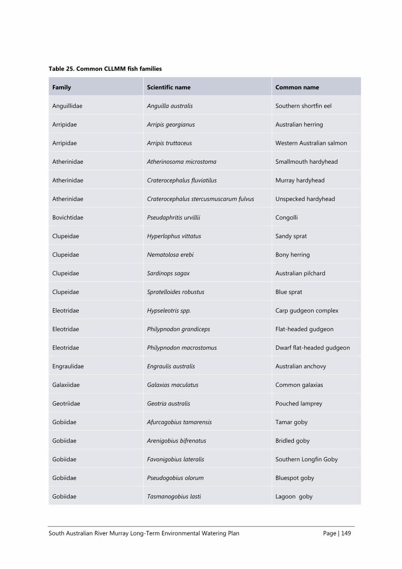
South Australian River Murray Long-Term Environmental Watering Plan Page | 149
Table 25. Common CLLMM fish families
Family Scientific name Common name
Anguillidae Anguilla australis Southern shortfin eel
Arripidae Arripis georgianus Australian herring
Arripidae Arripis truttaceus Western Australian salmon
Atherinidae Atherinosoma microstoma Smallmouth hardyhead
Atherinidae Craterocephalus fluviatilus Murray hardyhead
Atherinidae Craterocephalus stercusmuscarum fulvus Unspecked hardyhead
Bovichtidae Pseudaphritis urvillii Congolli
Clupeidae Hyperlophus vittatus Sandy sprat
Clupeidae Nematolosa erebi Bony herring
Clupeidae Sardinops sagax Australian pilchard
Clupeidae Spratelloides robustus Blue sprat
Eleotridae Hypseleotris spp. Carp gudgeon complex
Eleotridae Philypnodon grandiceps Flat-headed gudgeon
Eleotridae Philypnodon macrostomus Dwarf flat-headed gudgeon
Engraulidae Engraulis australis Australian anchovy
Galaxiidae Galaxias maculatus Common galaxias
Geotriidae Geotria australis Pouched lamprey
Gobiidae Afurcagobius tamarensis Tamar goby
Gobiidae Arenigobius bifrenatus Bridled goby
Gobiidae Favonigobius lateralis Southern Longfin Goby
Gobiidae Pseudogobius olorum Bluespot goby
Gobiidae Tasmanogobius lasti Lagoon goby
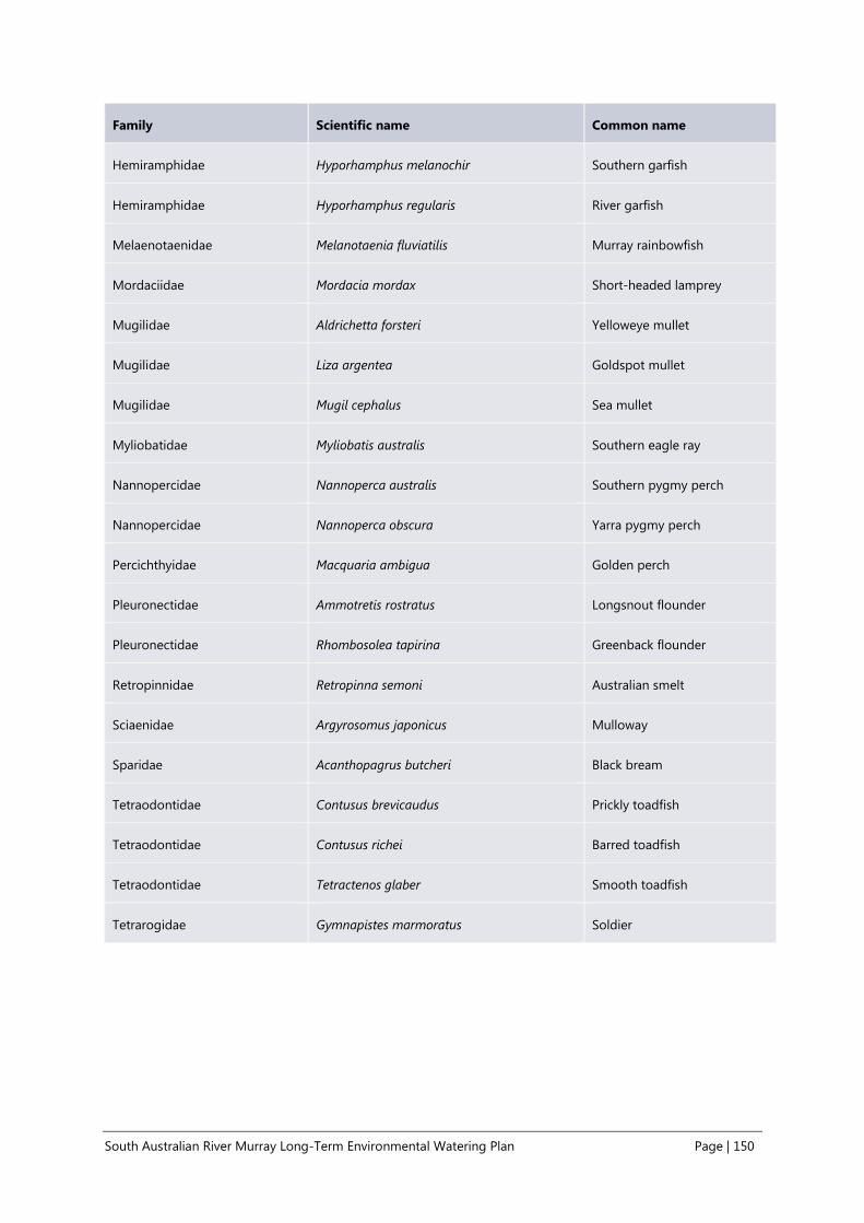
South Australian River Murray Long-Term Environmental Watering Plan Page | 150
Family Scientific name Common name
Hemiramphidae Hyporhamphus melanochir Southern garfish
Hemiramphidae Hyporhamphus regularis River garfish
Melaenotaenidae Melanotaenia fluviatilis Murray rainbowfish
Mordaciidae Mordacia mordax Short-headed lamprey
Mugilidae Aldrichetta forsteri Yelloweye mullet
Mugilidae Liza argentea Goldspot mullet
Mugilidae Mugil cephalus Sea mullet
Myliobatidae Myliobatis australis Southern eagle ray
Nannopercidae Nannoperca australis Southern pygmy perch
Nannopercidae Nannoperca obscura Yarra pygmy perch
Percichthyidae Macquaria ambigua Golden perch
Pleuronectidae Ammotretis rostratus Longsnout flounder
Pleuronectidae Rhombosolea tapirina Greenback flounder
Retropinnidae Retropinna semoni Australian smelt
Sciaenidae Argyrosomus japonicus Mulloway
Sparidae Acanthopagrus butcheri Black bream
Tetraodontidae Contusus brevicaudus Prickly toadfish
Tetraodontidae Contusus richei Barred toadfish
Tetraodontidae Tetractenos glaber Smooth toadfish
Tetrarogidae Gymnapistes marmoratus Soldier

South Australian River Murray Long-Term Environmental Watering Plan Page | 151
Appendix 5. Historical pump sites within the Channel and Floodplain Priority Environmental
Assets
Table 26. Commence-to-flows (ML/day QSA) for selected temporary wetlands within the SA River Murray
WRP Area
Wetlands are in order of increasing commence-to-flow (estimated upper value). This information has been
provided by the Natural Resources SA MDB section of DEWNR and is based on many years of wetland pumping
projects within the SA River Murray WRP Area.
Temporary Wetland Lock Reach
Estimated
surface area
(hectares)
Commence-to-flow53
EWR54 #
Estimated
lower value
(ML/day QSA)
Estimated
upper value
(ML/day QSA)
Templeton Lock 5 - 6 8
10,000 IC1
Old Loxton Road Lock 3 - 4 2 10,000 15,000 IC2
Piggy Creek Lock 3 - 4 33
25,000 IC4
Sugar Shack temporary basin
S0000556
Below Lock 1 5 20,000 25,000
IC4
Overland Corner - larger basin Lock 2 - 3 93 15,000 30,000 IC5
Whirlpool Corner Lock 5 - 6 11 15,000 30,000 IC5
Overland Corner - lignum
basins
Lock 2 - 3 93 15,000 30,000
IC5
Morgan Conservation Park
(Southern Lagoons)
Lock 1 - 2 15 20,000 30,000
IC5
Akuna wetland Lock 2 - 3 6
30,000 IC5
Markaranka South Lock 1 - 2 69
30,000 IC5
Wiela - pumped site Lock 5 - 6 7 30,000 IC5
Morgan East Lock 1 - 2 7 30,000 IC5
53 Commence-to-flow is an estimate only and is based on RiMFiM modelling outputs and ground-truthing where possible. Many wetland basins
have more than one inlet channel or there is a degree of uncertainty around when water begins to enter the wetland basin, hence upper and
lower commence-to-flow values are provided. 54 The EWR number relates to the lowest Channel or Floodplain EWR (provided in Table 4 and Table 6) likely to inundate the wetland, based on
the discharge metric of the EWR and the upper commence-to-flow value for the wetland. A comparison of the EWR duration and average return
interval metrics against the required duration and frequency of inundation for the specific wetland (based on the site-specific management
objectives) has not been undertaken. For example, the EWR duration may not be sufficient to provide frog and bird breeding outcomes in which
case a higher EWR would need to be delivered to achieve these outcomes or duration of inundation extended through pumping.

South Australian River Murray Long-Term Environmental Watering Plan Page | 152
Temporary Wetland Lock Reach
Estimated
surface area
(hectares)
Commence-to-flow53
EWR54 #
Estimated
lower value
(ML/day QSA)
Estimated
upper value
(ML/day QSA)
Yabby Creek and Katarapko
Basins
Lock 3 - 4 100 15,000 40,000
IC7
Wiela shedding basin Lock 5 - 6 2 30,000 40,000 IC7
Maize Island Lock 2 - 3 8 30,000 40,000 IC7
Carpark Lagoon Lock 3 - 4 15 40,000 45,000 FP1
Sugar Shack temporary basin
S0000555
Below Lock 1 1 40,000 45,000
FP1
Wigley Reach Lock 2 - 3 10 50,000 FP1
Molo Flat Lock 1 - 2 62
60,000 FP2
Katarapko Creek Lock 3 - 4 4
60,000 FP2
Martins Bend temporary
wetlands
Lock 4 - 5 16 25,000 65,000
FP3
Markaranka East Lock 1 - 2 9 65,000 FP3
Morgan Conservation Park
(Northern Lagoons)
Lock 1 - 2 18 65,000 70,000
FP3
Hogwash Bend Lock 1 - 2 25
75,000 FP4
Gerard black box waterings 5 TBD
Murtho Park temporary
wetland
10 TBD
Island Reach TBD
Gerard lignum basins TBD
Markaranka temporary
floodrunners
2 TBD
Nikalapko 46 TBD

South Australian River Murray Long-Term Environmental Watering Plan Page | 153