Embed Size (px)
Citation preview

Last Update: 7/20/2015
SOP Chapter 2: Data Schema Introduction This document includes stormwater features definitions
Target Audience The target audience for this document includes GIS editors, field personnel, managers and others who will view and interact with the data, including the following
Desktop Editors
Field Mappers
GIS Analysts
SWSS Personnel
Environmental Compliance Personnel
Modelers
Management
Stormwater Structure Definitions This mapping effort collects features based on a standardized, regional dictionary of stormwater features. The dictionary contains both structural and functional definitions. Several terms in the dictionary may share the same functional definition, but no two terms should ever share the same functional and the same structural definition. For example, many catch basin types share the same functional definition, but their structural definitions vary. Field personnel should be familiar with the dictionary: http://www.wastormwatercenter.org/files/library/kcmapping-dictionary.pdf
StormEdit Database The StormEdit Database is the central repository of King County's stormwater data. It complies with the NPDES Phase I Municipal Stormwater Permit, issued by the Washington State Department of Ecology. Among other conditions, the permit requires King County to maintain an ongoing Municipal Separate Stormwater Sewer System (MS4) mapping program for areas within the permit’s jurisdictional boundaries. The StormEdit Database is based on the Puget Sound Stormwater Infrastructure Framework and supplemented to meet King County's business needs. The Puget Sound Stormwater Infrastructure Framework defines common stormwater features and organizes them with a hierarchical structure. "Function," "Function Type," "Component," and "Component Type" are hierarchical levels from the framework project, listed here in order of detail from broad to fine scale. The following resources may be helpful in understanding the data structure: Hierarchical Framework Chart, Feature Attribute Chart, and Dictionary at http://www.wastormwatercenter.org/stormwater-infrastructure-framework-resources/ Connection Feature Classes When mapping a Conn_ point (Sump, No Sump, Access), do not count tanks in the pipe count if the tank ties directly into the connect feature. However, a pipe that ties into both the connect feature and a tank does count in the pipe count.

Last Update: 7/20/2015
Non-Standard connection features may be mapped in two ways. 1. Many features in large part resemble a current standard set forth in the Component Type
definitions. However, the structure may match an older, deprecated standard that differs slightly from the current standard, or maybe a slight adjustment was made to the structure. These features are best mapped with the Component Type they most resemble (e.g. Catch Basin Type 1) and completion of the DesignType column with “Non-Standard” to show that it deviates slightly from the definition for that standard.
2. Features that do not resemble any of the current standards, as outlined in the Component Type definitions, should be mapped with a Component Type of “Non-Standard” and the DesignType column should have a “Non-Standard” value as well. These structures are most likely homemade and unusual.
Feature Class Schema StormEdit.STORMWATERMOBILEDBO.Conn_Sump Function Connect: a stormwater system function that serves as either a connection with conveyance or control features or a connection of the stormwater management system to surface or subsurface flows. Function Type -Sump: A connecting structure designed to interrupt the flow of rainwater and allow for settling and collection of sediment, debris, detritus, contaminants, etc., prior to transfer to the outlet pipe. These structures generally contain an opening for stormwater inflow. Components --Grate Inlet Type 1: A structure that is rectangular and has a rectangular, metal grate and a Sump; cannot support traffic loads. Interior Dimensions 23" Wide x 42" Long x Variable Depth, 12’ Max.; Max Depth to Pipe invert is 9’ 6”. For more detail see WSDOT Standard Plans (B-35.20-00). --Catch Basin: A structure that functions with a Sump to either allow for water to enter a Conveyance System or connect with other Conveyance features, or both. Catch basins are circular or rectangular and usually have a grated metal lid or cover. Non-Standard Sump: A structure with a sump that does not meet the structural requirement of any contemporary design standards. Component Types ---Catch Basin Type 1: Rectilinear structure with interior dimensions 22" Wide x 26" Long x 40" Deep; Max knockout size 20” diameter. Max Depth to Pipe invert is 5'. For more detail see WSDOT Standard Plans (B-5.20). ---Catch Basin Type 1L: Rectilinear structure with interior dimensions 28" Wide x 32" Long x 40" Deep; Max knockout size 26” diameter. Max Depth to Pipe invert is 5'. For more detail see WSDOT Standard Plans (B-5.40). ---Catch Basin Type 1P: Rectilinear structure with interior dimensions 22" Wide x 26" Long x 52" Deep; Max knockout size 16” diameter. Max Depth to Pipe invert is 5'. For more detail see WSDOT Standard Plans (B-5.60). ---Catch Basin Type 2: Cylindrical structure with interior diameter 36” or greater, typically 15’ max depth to bottom, 24” Sump. For more detail see WSDOT Standard Plans (B-10.20). ---Grate Inlet Type 1: (defined above at component level) Fields

Last Update: 7/20/2015
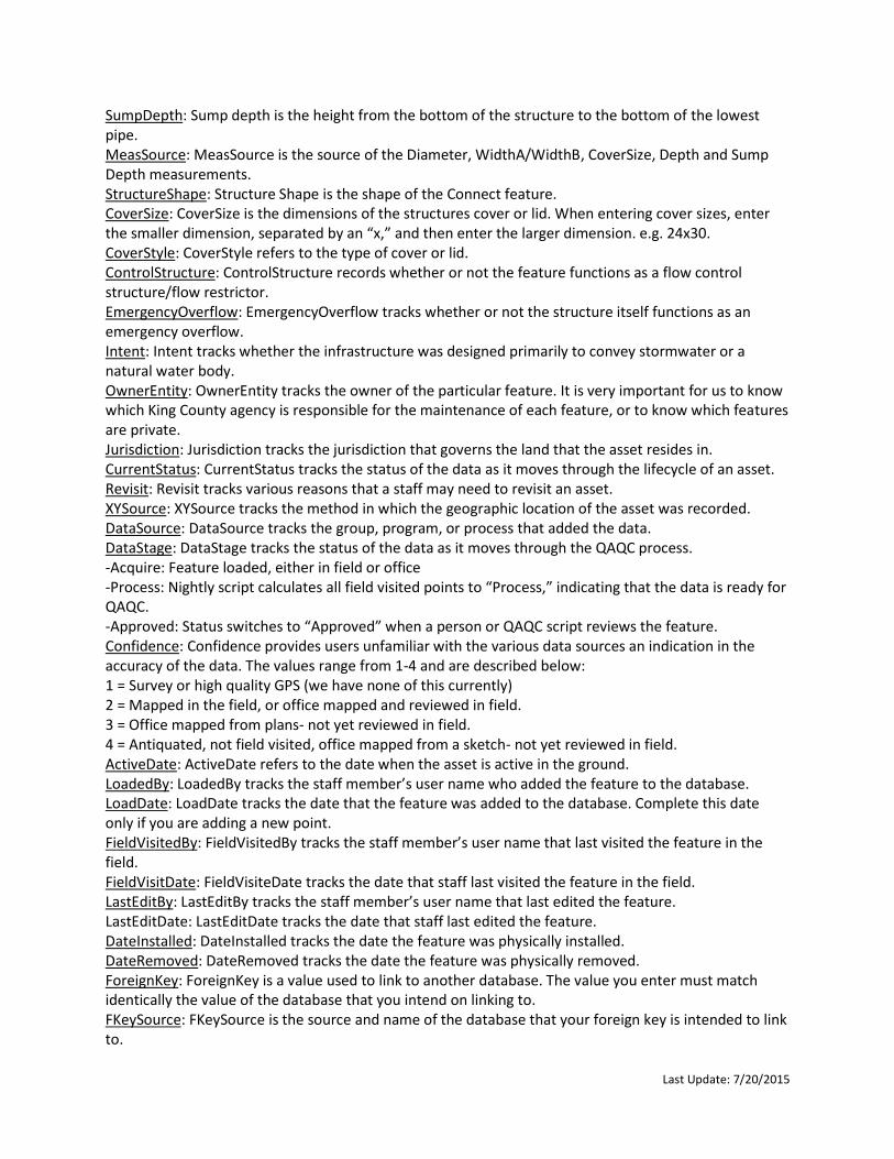
OBJECTID: An ObjectID is a unique, not null integer field used to uniquely identify rows in tables in a geodatabase. The values in this field are maintained by ArcGIS. The ObjectID is used by ArcGIS to do such things as scroll, display selection sets, and perform identify operations on features. AssetID: AssetID is the unique identifier that is used to tie to Cityworks, MIS, or some other database. The AssetID is unique for each feature class and is generated by a script that runs nightly. Users should not modify the AssetID. Component: Within the Puget Sound Stormwater Infrastructure Framework, Component is the broadest classification for a set of structures with a similar Function and Function Type. ComponentType: Within the Puget Sound Stormwater Infrastructure Framework, Component Type is the finest classification for a structure. DesignType: DesignType specifies whether the structure meets a current design standard (e.g. Surface Water Design Manual or Roads Design and Construction Standards). PipeCount: Pipe Count is the number of pipes, of any size, that connect to a Connect feature. Tanks that connect directly to the Connect structure are not included in the Pipe Count. However, pipes tying into the Connect structure and a tank should be included in the Pipe Count. Material: Material is the primary material that the Connect feature is constructed of. Diameter: Diameter is the average inner diameter of the Connect structure, not the opening (cover frame or slab). WidthA: WidthA is the average inner width of the Connect structure, not the opening (cover frame or slab). Enter the smaller of the two widths in the WidthA column. WidthB: WidthB is the average inner width of the Connect structure, not the opening (cover frame or slab). Enter the larger of the two widths in the WidthB column. MeasSource: MeasSource is the source of the Diameter, WidthA/WidthB, CoverSize, Depth and Sump Depth measurements. SumpDepth: Sump depth is the height from the bottom of the structure to the bottom of the lowest pipe. TotalDepth: Total depth is height from the bottom of the structure to the top at rim of the lid.CoverElevation: Cover elevation is the elevation in feet at the center of structure’s lid. This is often shown on design plans. OutletElevation: Outlet elevation is elevation in feet at the base interior level (invert) of the outlet pipe. StructureShape: Structure Shape is the shape of the Connect feature. CoverSize: CoverSize is the dimensions of the structures cover or lid. When entering cover sizes, enter the smaller dimension, separated by an “x,” and then enter the larger dimension. e.g. 24x30. CoverStyle: CoverStyle refers to the type of cover or lid. LockingCover: LockingCover tracks whether or not the cover or lid has the ability to lock. This includes self-locking lids, and when the rim has threaded holes, even if the lid doesn’t have holes that allow the cover to be locked. JailHouseWindow: Jailhouse windows are found in outlet structures of ponds. They are openings with vertical bars that prevent debris from entering the outlet. ControlStructure: ControlStructure records whether or not the feature functions as a flow control structure/flow restrictor. EmergencyOverflow: EmergencyOverflow tracks whether or not the structure itself functions as an emergency overflow. SpillControl: SpillControl tracks whether or not the structure has a spill control device, like a down-turned elbow or T-section without a restrictor plate. Spill control devices are sometimes referred to “oil-water separators” among King County staff, but “oil-water separators” function differently and are only found in vaults. FlowSplitter: FlowSplitter tracks whether or not the structure has a flow splitter.

Last Update: 7/20/2015
ProprietaryDevice: Proprietary devices are those features that are only produced by one company only. These are commonly water quality treatment devices. Intent: Intent tracks whether the infrastructure was designed primarily to convey stormwater or a natural water body. OwnerEntity: OwnerEntity tracks the owner of the particular feature. It is very important for us to know which King County agency is responsible for the maintenance of each feature, or to know which features are private. Jurisdiction: Jurisdiction tracks the jurisdiction that governs the land that the asset resides in. DataStage: DataStage tracks the status of the data as it moves through the QAQC process.
Acquire: Feature loaded, either in field or office
Process: Nightly script calculates all field visited points to “Process,” indicating that the data is ready for QAQC.
Approved: Status switches to “Approved” when a person or QAQC script reviews the feature. CurrentStatus: CurrentStatus tracks the status of the data as it moves through the lifecycle of an asset. Revisit: Revisit tracks various reasons that a staff may need to revisit an asset. XYSource: XYSource tracks the method in which the geographic location of the asset was recorded. DataSource: DataSource tracks the group, program, or process that added the data. Confidence: Confidence provides users unfamiliar with the various data sources an indication in the accuracy of the data. The values range from 1-4 and are described below: 1 = Survey or high quality GPS (we have none of this currently) 2 = Mapped in the field, or office mapped and reviewed in field. 3 = Office mapped from plans- not yet reviewed in field. 4 = Antiquated, not field visited, office mapped from a sketch- not yet reviewed in field. Verified: Verified tracks if the Component and ComponentType of a feature have been verified by staff in the field or referencing design plans or some other reliable source. ActiveDate: ActiveDate refers to the date when the asset is active in the ground. LoadedBy: LoadedBy tracks the staff member’s user name who added the feature to the database. LoadDate: LoadDate tracks the date that the feature was added to the database. Complete this date only if you are adding a new point. FieldVisitedBy: FieldVisitedBy tracks the staff member’s user name that last visited the feature in the field. FieldVisitDate: FieldVisiteDate tracks the date that staff last visited the feature in the field. LastEditBy: LastEditBy tracks the staff member’s user name that last edited the feature. LastEditDate: LastEditDate tracks the date that staff last edited the feature. DateInstalled: DateInstalled tracks the date the feature was physically installed. DateRemoved: DateRemoved tracks the date the feature was physically removed. ForeignKey: ForeignKey is a value used to link to another database. The value you enter must match identically the value of the database that you intend on linking to. FKeySource: FKeySource is the source and name of the database that your foreign key is intended to link to. MISComponentID: MISComponentID is used to track the Maintenance & Inspection System (MIS) ComponentID value for a feature. FacilityID: FacilityID tracks the FacilityID number that the feature is a part of. PlanLink: When digital plans are available, PlanLink provides a hyperlink to plan files.Notes: Notes provides extra space for staff to enter additional information not captured in other fields. QCFlag: QCFlag provides a space for QC scripts to write quality control issues for staff to potentially resolve. Shape: Shape is used by ArcGIS to store the geometry of a feature.

Last Update: 7/20/2015
GlobalID: GobalID is a 36 character string that ArcGIS uses to uniquely identify features or table rows within a geodatabase and across geodatabases. ------------------------------------------------------------------------------------------------------------------------------------------
StormEdit.STORMWATERMOBILEDBO.Conn_NoSump Function Connect: A stormwater system function that serves as either a connection with conveyance or control features or a connection of the stormwater management system to surface or subsurface flows. Function Type -No Sump: A connecting structure without a sump. These structures generally contain an opening for stormwater inflow. Components --Concrete/Curb Inlet: A square shaped structure without a Sump. These structures are generally used to accept stormwater inflow through a curb opening. --Grate Inlet Type 2: A structure that is rectangular and has a rectangular, metal grate and no Sump; welded grates on this type can only be subjected to light traffic. Interior Dimensions 23" Wide x 42" Long x Variable Depth; Max Depth to Pipe invert is 9’ 7.5”. For more detail see WSDOT Standard Plans (B-35.40-00). --Drop Inlet: A trapezoidal shaped structure without a Sump. Designed with a high hydraulic capacity, these structures are effective in passing large debris. The grates of these structures are generally on grade and accept flow. --Type 2 Inlet: A round shaped structure without a Sump. These structures are generally used to accept stormwater inflow through a curb opening. --Non-Standard NoSump: A connecting structure without a sump that does not meet the structural requirement of any contemporary design standards. Component Types ---Concrete/Curb Inlet: (defined above at component level) ---Drop Inlet Type 1: Terminates Ditch, inflow from one side. Trapezoidal structure with interior dimensions: 30” Wide x ~72” Long x ~48" Deep; Max knockout size 34” diameter. For more detail see WSDOT Standard Plans (B-45.20-00). ---Drop Inlet Type 2: Positioned at mid-Ditch, inflow from two sides. Trapezoidal structure with interior dimensions: 30” Wide x 108” Long x ~48" Deep; Max knockout size 34” diameter. For more detail see WSDOT Standard Plans (B-45.40-00) ---Grate Inlet Type 2: (defined above at component level) ---Deep Inlet Type 2: (defined above at component level) ---Type 2 Inlet: (defined above at component level) Fields OBJECTID: An ObjectID is a unique, not null integer field used to uniquely identify rows in tables in a geodatabase. The values in this field are maintained by ArcGIS. The ObjectID is used by ArcGIS to do such things as scroll, display selection sets, and perform identify operations on features. AssetID: AssetID is the unique identifier that is used to tie to Cityworks, MIS, or some other database. The AssetID is unique for each feature class and is generated by a script that runs nightly. Users should not modify the AssetID. Component: Within the Puget Sound Stormwater Infrastructure Framework, Component is the broadest classification for a set of structures with a similar Function and Function Type.

Last Update: 7/20/2015
ComponentType: Within the Puget Sound Stormwater Infrastructure Framework, Component Type is the finest classification for a structure. DesignType: DesignType specifies whether the structure meets a current design standard (e.g. Surface Water Design Manual or Roads Design and Construction Standards). Material: Material is the primary material that the Connect feature is constructed of. PipeCount: Pipe Count is the number of pipes, of any size, that connect to a Connect feature. Tanks that connect directly to the Connect structure are not included in the Pipe Count. However, pipes tying into the Connect structure and a tank should be included in the Pipe Count. Diameter: Diameter is the average inner diameter of the Connect structure, not the opening (cover frame or slab). WidthA: WidthA is the average inner width of the Connect structure, not the opening (cover frame or slab). Enter the smaller of the two widths in the WidthA column. WidthB: WidthB is the average inner width of the Connect structure, not the opening (cover frame or slab). Enter the larger of the two widths in the WidthB column. StructureShape: Structure Shape is the shape of the Connect feature. TotalDepth: Total depth is height from the bottom of the structure to the top at rim of the lid. CoverElevation: Cover elevation is the elevation in feet at the center of structure’s lid. This is often shown on design plans. OutletElevation: Outlet elevation is elevation in feet at the base interior level (invert) of the outlet pipe. CoverSize: CoverSize is the dimensions of the structures cover or lid. When entering cover sizes, enter the smaller dimension, separated by an “x,” and then enter the larger dimension. e.g. 24x30. CoverStyle: CoverStyle refers to the type of cover or lid. MeasSource: MeasSource is the source of the Diameter, WidthA/WidthB, CoverSize, Depth and Sump Depth measurements. EmergencyOverflow: EmergencyOverflow tracks whether or not the structure itself functions as an emergency overflow. FlowSplitter: FlowSplitter tracks whether or not the structure has a flow splitter. ProprietaryDevice: Proprietary devices are those features that are only produced by one company only. These are commonly water quality treatment devices. NumberCartridges: The number of water quality cartridges within the structure. Intent: Intent tracks whether the infrastructure was designed primarily to convey stormwater or a natural water body. OwnerEntity: OwnerEntity tracks the owner of the particular feature. It is very important for us to know which King County agency is responsible for the maintenance of each feature, or to know which features are private. Jurisdiction: Jurisdiction tracks the jurisdiction that governs the land that the asset resides in. Revisit: Revisit tracks various reasons that a staff may need to revisit an asset. XYSource: XYSource tracks the method in which the geographic location of the asset was recorded. Confidence: Confidence provides users unfamiliar with the various data sources an indication in the accuracy of the data. The values range from 1-4 and are described below: 1 = Survey or high quality GPS (we have none of this currently) 2 = Mapped in the field, or office mapped and reviewed in field. 3 = Office mapped from plans- not yet reviewed in field. 4 = Antiquated, not field visited, office mapped from a sketch- not yet reviewed in field. Verified: Verified tracks if the Component and ComponentType of a feature have been verified by staff in the field or referencing design plans or some other reliable source. ActiveDate: ActiveDate refers to the date when the asset is active in the ground. LoadedBy: LoadedBy tracks the staff member’s user name who added the feature to the database.

Last Update: 7/20/2015
LoadDate: LoadDate tracks the date that the feature was added to the database. Complete this date only if you are adding a new point. FieldVisitedBy: FieldVisitedBy tracks the staff member’s user name that last visited the feature in the field. FieldVisitDate: FieldVisiteDate tracks the date that staff last visited the feature in the field. LastEditBy: LastEditBy tracks the staff member’s user name that last edited the feature. LastEditDate: LastEditDate tracks the date that staff last edited the feature. DateInstalled: DateInstalled tracks the date the feature was physically installed. DateRemoved: DateRemoved tracks the date the feature was physically removed. ForeignKey: ForeignKey is a value used to link to another database. The value you enter must match identically the value of the database that you intend on linking to. FKeySource: FKeySource is the source and name of the database that your foreign key is intended to link to. MISComponentID: MISComponentID is used to track the Maintenance & Inspection System (MIS) ComponentID value for a feature. FacilityID: FacilityID tracks the FacilityID number that the feature is a part of. PlanLink: When digital plans are available, PlanLink provides a hyperlink to plan files. DataStage: DataStage tracks the status of the data as it moves through the QAQC process. -Acquire: Feature loaded, either in field or office -Process: Nightly script calculates all field visited points to “Process,” indicating that the data is ready for QAQC. -Approved: Status switches to “Approved” when a person or QAQC script reviews the feature. CurrentStatus: CurrentStatus tracks the status of the data as it moves through the lifecycle of an asset. DataSource: DataSource tracks the group, program, or process that added the data. Notes: Notes provides extra space for staff to enter additional information not captured in other fields. QCFlag: QCFlag provides a space for QC scripts to write quality control issues for staff to potentially resolve. Shape: Shape is used by ArcGIS to store the geometry of a feature. GlobalID: GobalID is a 36 character string that ArcGIS uses to uniquely identify features or table rows
within a geodatabase and across geodatabases.
------------------------------------------------------------------------------------------------------------------------------------------
StormEdit.STORMWATERMOBILEDBO.Conn_Access Function Connect: a stormwater system function that serves as either a connection with conveyance or control features or a connection of the stormwater management system to surface or subsurface flows. Function Type -Access: An opening or structure that provides maintenance or inspection access to the stormwater management system. These structures are not designed to accept stormwater inflow. Components --Access Riser: A vertical maintenance access to a Vault, Tank or other similar structure. The access opening is wide enough for entry to support maintenance and inspection. --Cleanout: A Pipe with a cap that allows for cleaning or inspection of the Conveyance System. --Non-Standard Access: An access structure that does not meet the structural requirement of any contemporary design standards.

Last Update: 7/20/2015
--Manhole: Manholes connect one Pipe to another Pipe, with an opening to the surface. Structurally, manholes are cylindrical, deeper than wide, has an access opening, and without a Sump. Pipe outlet(s) are at the base of structure, often in “channel and shelf”. Component Types ---Access Riser: Defined above at Component level. ---Cleanout: Defined above at Component level. ---Manhole Type 1: Cylindrical structure with diameter of 48, 54 or 60 inches, 8 feet min depth to bottom, including a riser cone. For Pipes needing knockout larger than 48", use Manhole Type 2. For more detail see WSDOT Standard Plans (B-15.20) ---Manhole Type 2: Cylindrical structure with diameter of 72 + inches. For Pipes needing knockout larger than 48”. Max Depth 20', including a riser cone. For more detail see WSDOT Standard Plans (B-15.40). ---Manhole Type 3: Cylindrical structure with diameter of 36 + inches. For installation depths of less than 8 feet. Can accommodate any size Pipe depending on the diameter of the structure. For more detail see WSDOT Standard Plans (B-15.60). ---Manhole Type 4: Cylindrical structure with diameter of 48” concrete Manhole risers, stacked to a max of 12’ on top of a 48” or greater conveyance Pipe. Utilizes the conveyance pipe as the base of the structure. For more detail see King County Roads Standards Figure 7-010). ---Non-Standard Manhole: A manhole structure that does not meet the structural requirement of any contemporary design standards. Fields OBJECTID: An ObjectID is a unique, not null integer field used to uniquely identify rows in tables in a geodatabase. The values in this field are maintained by ArcGIS. The ObjectID is used by ArcGIS to do such things as scroll, display selection sets, and perform identify operations on features. AssetID: AssetID is the unique identifier that is used to tie to Cityworks, MIS, or some other database. The AssetID is unique for each feature class and is generated by a script that runs nightly. Users should not modify the AssetID. Component: Within the Puget Sound Stormwater Infrastructure Framework, Component is the broadest classification for a set of structures with a similar Function and Function Type. ComponentType: Within the Puget Sound Stormwater Infrastructure Framework, Component Type is the finest classification for a structure. ComponentType for Access Risers and Clean Outs should be left blank (null). DesignType: DesignType specifies whether the structure meets a current design standard (e.g. Surface Water Design Manual or Roads Design and Construction Standards). Material: Material is the primary material that the Connect feature is constructed of. PipeCount: Pipe Count is the number of pipes, of any size, that connect to a Connect feature. Tanks that connect directly to the Connect structure are not included in the Pipe Count. However, pipes tying into the Connect structure and a tank should be included in the Pipe Count. Diameter: Diameter is the average inner diameter of the Connect structure, not the opening (cover frame or slab). WidthA: WidthA is the average inner width of the Connect structure, not the opening (cover frame or slab). Enter the smaller of the two widths in the WidthA column. WidthB: WidthB is the average inner width of the Connect structure, not the opening (cover frame or slab). Enter the larger of the two widths in the WidthB column. StructureShape: Structure Shape is the shape of the Connect feature. TotalDepth: Total depth is height from the bottom of the structure to the top at rim of the lid. CoverSize: CoverSize is the dimensions of the structures cover or lid. When entering cover sizes, enter the smaller dimension, separated by an “x,” and then enter the larger dimension. e.g. 24x30.

Last Update: 7/20/2015
CoverStyle: CoverStyle refers to the type of cover or lid. LockingCover: LockingCover tracks whether or not the cover or lid has the ability to lock. This includes self-locking lids, and when the rim has threaded holes, even if the lid doesn’t have holes that allow the cover to be locked. JailHouseWindow: Jailhouse windows are found in outlet structures of ponds. They are openings with vertical bars that prevent debris from entering the outlet. MeasSource: MeasSource is the source of the Diameter, WidthA/WidthB, CoverSize, Depth and Sump Depth measurements. CoverElevation: Cover elevation is the elevation in feet at the center of structure’s lid. This is often shown on design plans. OutletElevation: Outlet elevation is elevation in feet at the base interior level (invert) of the outlet pipe. EmergencyOverflow: EmergencyOverflow tracks whether or not the structure itself functions as an emergency overflow. ProprietaryDevice: Proprietary devices are those features that are only produced by one company only. These are commonly water quality treatment devices. NumberCartridges: The number of water quality cartridges within the structure. Intent: Intent tracks whether the infrastructure was designed primarily to convey stormwater or a natural water body. OwnerEntity: OwnerEntity tracks the owner of the particular feature. It is very important for us to know which King County agency is responsible for the maintenance of each feature, or to know which features are private. CurrentStatus: CurrentStatus tracks the status of the data as it moves through the lifecycle of an asset. Jurisdiction: Jurisdiction tracks the jurisdiction that governs the land that the asset resides in. Revisit: Revisit tracks various reasons that a staff may need to revisit an asset. XYSource: XYSource tracks the method in which the geographic location of the asset was recorded. DataSource: DataSource tracks the group, program, or process that added the data. Verified: Verified tracks if the Component and ComponentType of a feature have been verified by staff in the field or referencing design plans or some other reliable source. DataStage: DataStage tracks the status of the data as it moves through the QAQC process. -Acquire: Feature loaded, either in field or office -Process: Nightly script calculates all field visited points to “Process,” indicating that the data is ready for QAQC. -Approved: Status switches to “Approved” when a person or QAQC script reviews the feature. Confidence: Confidence provides users unfamiliar with the various data sources an indication in the accuracy of the data. The values range from 1-4 and are described below: 1 = Survey or high quality GPS (we have none of this currently) 2 = Mapped in the field, or office mapped and reviewed in field. 3 = Office mapped from plans- not yet reviewed in field. 4 = Antiquated, not field visited, office mapped from a sketch- not yet reviewed in field. ActiveDate: ActiveDate refers to the date when the asset is active in the ground. LoadedBy: LoadedBy tracks the staff member’s user name who added the feature to the database. LoadDate: LoadDate tracks the date that the feature was added to the database. Complete this date only if you are adding a new point. FieldVisitedBy: FieldVisitedBy tracks the staff member’s user name that last visited the feature in the field. FieldVisitDate: FieldVisiteDate tracks the date that staff last visited the feature in the field. LastEditBy: LastEditBy tracks the staff member’s user name that last edited the feature. LastEditDate: LastEditDate tracks the date that staff last edited the feature.

Last Update: 7/20/2015
DateInstalled: DateInstalled tracks the date the feature was physically installed. DateRemoved: DateRemoved tracks the date the feature was physically removed. ForeignKey: ForeignKey is a value used to link to another database. The value you enter must match identically the value of the database that you intend on linking to. FKeySource: FKeySource is the source and name of the database that your foreign key is intended to link to. MISComponentID: MISComponentID is used to track the Maintenance & Inspection System (MIS) ComponentID value for a feature. FacilityID: FacilityID tracks the FacilityID number that the feature is a part of. PlanLink: When digital plans are available, PlanLink provides a hyperlink to plan files. Notes: Notes provides extra space for staff to enter additional information not captured in other fields. QCFlag: QCFlag provides a space for QC scripts to write quality control issues for staff to potentially resolve. Shape: Shape is used by ArcGIS to store the geometry of a feature. GlobalID: GobalID is a 36 character string that ArcGIS uses to uniquely identify features or table rows
within a geodatabase and across geodatabases.
------------------------------------------------------------------------------------------------------------------------------------------
StormEdit.STORMWATERMOBILEDBO.Conn_UndefinedType Function Connect: a stormwater system function that serves as either a connection with conveyance or control features or a connection of the stormwater management system to surface or subsurface flows. Function Type -Undefined Type: A connector point that is yet to be defined, or needs to be attributed with component
type and other attribution. These typically are created from design plans, CAD or other sources where
the specific component type was left undefined. Any attribution within the UndefinedType entered by
office staff helps the field staff identify the feature. These are created in the office and sent as a query
to the field for investigation. The field staff go to the location, determine the feature’s appropriate
classification, and then map the feature in the appropriate feature class. They then retire the
UndefinedType point once the feature is mapped appropriately in another feature class.
Fields OBJECTID: An ObjectID is a unique, not null integer field used to uniquely identify rows in tables in a geodatabase. The values in this field are maintained by ArcGIS. The ObjectID is used by ArcGIS to do such things as scroll, display selection sets, and perform identify operations on features. PipeCount: Pipe Count is the number of pipes, of any size, that connect to a Connect feature. Tanks that connect directly to the Connect structure are not included in the Pipe Count. However, pipes tying into the Connect structure and a tank should be included in the Pipe Count. Material: Material is the primary material that the Connect feature is constructed of. Diameter: Diameter is the average interior diameter of the Connect structure, not the opening (cover frame or slab). WidthA: WidthA is the average inner width of the Connect structure, not the opening (cover frame or slab). Enter the smaller of the two widths in the WidthA column. WidthB: WidthB is the average inner width of the Connect structure, not the opening (cover frame or slab). Enter the larger of the two widths in the WidthB column. TotalDepth: Total depth is height from the bottom of the structure to the top at rim of the lid.
Last Update: 7/20/2015
SumpDepth: Sump depth is the height from the bottom of the structure to the bottom of the lowest pipe. MeasSource: MeasSource is the source of the Diameter, WidthA/WidthB, CoverSize, Depth and Sump Depth measurements. StructureShape: Structure Shape is the shape of the Connect feature. CoverSize: CoverSize is the dimensions of the structures cover or lid. When entering cover sizes, enter the smaller dimension, separated by an “x,” and then enter the larger dimension. e.g. 24x30. CoverStyle: CoverStyle refers to the type of cover or lid. ControlStructure: ControlStructure records whether or not the feature functions as a flow control structure/flow restrictor. EmergencyOverflow: EmergencyOverflow tracks whether or not the structure itself functions as an emergency overflow. Intent: Intent tracks whether the infrastructure was designed primarily to convey stormwater or a natural water body. OwnerEntity: OwnerEntity tracks the owner of the particular feature. It is very important for us to know which King County agency is responsible for the maintenance of each feature, or to know which features are private. Jurisdiction: Jurisdiction tracks the jurisdiction that governs the land that the asset resides in. CurrentStatus: CurrentStatus tracks the status of the data as it moves through the lifecycle of an asset. Revisit: Revisit tracks various reasons that a staff may need to revisit an asset. XYSource: XYSource tracks the method in which the geographic location of the asset was recorded. DataSource: DataSource tracks the group, program, or process that added the data. DataStage: DataStage tracks the status of the data as it moves through the QAQC process. -Acquire: Feature loaded, either in field or office -Process: Nightly script calculates all field visited points to “Process,” indicating that the data is ready for QAQC. -Approved: Status switches to “Approved” when a person or QAQC script reviews the feature. Confidence: Confidence provides users unfamiliar with the various data sources an indication in the accuracy of the data. The values range from 1-4 and are described below: 1 = Survey or high quality GPS (we have none of this currently) 2 = Mapped in the field, or office mapped and reviewed in field. 3 = Office mapped from plans- not yet reviewed in field. 4 = Antiquated, not field visited, office mapped from a sketch- not yet reviewed in field. ActiveDate: ActiveDate refers to the date when the asset is active in the ground. LoadedBy: LoadedBy tracks the staff member’s user name who added the feature to the database. LoadDate: LoadDate tracks the date that the feature was added to the database. Complete this date only if you are adding a new point. FieldVisitedBy: FieldVisitedBy tracks the staff member’s user name that last visited the feature in the field. FieldVisitDate: FieldVisiteDate tracks the date that staff last visited the feature in the field. LastEditBy: LastEditBy tracks the staff member’s user name that last edited the feature. LastEditDate: LastEditDate tracks the date that staff last edited the feature. DateInstalled: DateInstalled tracks the date the feature was physically installed. DateRemoved: DateRemoved tracks the date the feature was physically removed. ForeignKey: ForeignKey is a value used to link to another database. The value you enter must match identically the value of the database that you intend on linking to. FKeySource: FKeySource is the source and name of the database that your foreign key is intended to link to.

Last Update: 7/20/2015
Notes: Notes provides extra space for staff to enter additional information not captured in other fields. QCFlag: QCFlag provides a space for QC scripts to write quality control issues for staff to potentially resolve. Shape: Shape is used by ArcGIS to store the geometry of a feature. GlobalID: GobalID is a 36 character string that ArcGIS uses to uniquely identify features or table rows
within a geodatabase and across geodatabases.
------------------------------------------------------------------------------------------------------------------------------------------
StormEdit.STORMWATERMOBILEDBO.Conn_Pump Function Connect: a stormwater system function that serves as either a connection with conveyance or control features or a connection of the stormwater management system to surface or subsurface flows. Function Type -Pump: A powered or mechanical device that conveys water from a lower elevation to a higher elevation along a specified length. Fields OBJECTID: An ObjectID is a unique, not null integer field used to uniquely identify rows in tables in a geodatabase. The values in this field are maintained by ArcGIS. The ObjectID is used by ArcGIS to do such things as scroll, display selection sets, and perform identify operations on features. AssetID: AssetID is the unique identifier that is used to tie to Cityworks, MIS, or some other database. The AssetID is unique for each feature class and is generated by a script that runs nightly. Users should not modify the AssetID. StationName: StationName is the common name of the pump station. OverflowLocation: OverflowLocation is the waterbody that the pump overflow discharges to. OverflowElevFt: OverflowElevFt is the elevation in feet of the pump's overflow. StationElevFt: StationElevFt is the elevation in feet of the pump station. WetWellInletFt: WetWellInletFt is the elevation in feet of the wet well inlet. MaxWetWellLevel: MaxWetWellLevel is the level in feet of the maximum wet well level. HighLevelAlarmFt: HighLevelAlarmFt is the level in feet that triggers the high level alarm. PumpCapacityGPM: PumpCapacityGPM is the pump capacity in gallons per minute. PumpCapacityFtHead: PumpCapacityFtHead is the pump capacity's feet of head. NumberOfPumps: NumberOfPumps is the count of pumps in the pump station. LevelMeasMethod: LevelMeasMethod is the method used in the level measurements. PumpOperation: PumpOperation specifies the method of pump operation. PowerSource: PowerSource specifies the source of power for the pump. EmergencyContactLink: EmergencyContactLink links users to the emergency contact for the pump. MoreInfoLink: MoreInfoLink links users to any additional documentation about the pump. ControlStructure: ControlStructure records whether or not the feature functions as a flow control structure/flow restrictor. Intent: Intent tracks whether the infrastructure was designed primarily to convey stormwater or a natural water body. OwnerEntity: OwnerEntity tracks the owner of the particular feature. It is very important for us to know which King County agency is responsible for the maintenance of each feature, or to know which features are private. Jurisdiction: Jurisdiction tracks the jurisdiction that governs the land that the asset resides in. Revisit: Revisit tracks various reasons that a staff may need to revisit an asset.

Last Update: 7/20/2015
XYSource: XYSource tracks the method in which the geographic location of the asset was recorded. Confidence: Confidence provides users unfamiliar with the various data sources an indication in the accuracy of the data. The values range from 1-4 and are described below: 1 = Survey or high quality GPS (we have none of this currently) 2 = Mapped in the field, or office mapped and reviewed in field. 3 = Office mapped from plans- not yet reviewed in field. 4 = Antiquated, not field visited, office mapped from a sketch- not yet reviewed in field. Verified: Verified tracks if the Component and ComponentType of a feature have been verified by staff in the field or referencing design plans or some other reliable source. ActiveDate: ActiveDate refers to the date when the asset is active in the ground. LoadedBy: LoadedBy tracks the staff member’s user name who added the feature to the database. LoadDate: LoadDate tracks the date that the feature was added to the database. Complete this date only if you are adding a new point. FieldVisitedBy: FieldVisitedBy tracks the staff member’s user name that last visited the feature in the field. FieldVisitDate: FieldVisiteDate tracks the date that staff last visited the feature in the field. LastEditBy: LastEditBy tracks the staff member’s user name that last edited the feature. LastEditDate: LastEditDate tracks the date that staff last edited the feature. DateInstalled: DateInstalled tracks the date the feature was physically installed. DateRemoved: DateRemoved tracks the date the feature was physically removed. ForeignKey: ForeignKey is a value used to link to another database. The value you enter must match identically the value of the database that you intend on linking to. FKeySource: FKeySource is the source and name of the database that your foreign key is intended to link to. DataStage: DataStage tracks the status of the data as it moves through the QAQC process. -Acquire: Feature loaded, either in field or office -Process: Nightly script calculates all field visited points to “Process,” indicating that the data is ready for QAQC. -Approved: Status switches to “Approved” when a person or QAQC script reviews the feature. CurrentStatus: CurrentStatus tracks the status of the data as it moves through the lifecycle of an asset. DataSource: DataSource tracks the group, program, or process that added the data. Notes: Notes provides extra space for staff to enter additional information not captured in other fields. QCFlag: QCFlag provides a space for QC scripts to write quality control issues for staff to potentially resolve. Shape: Shape is used by ArcGIS to store the geometry of a feature. GlobalID: GobalID is a 36 character string that ArcGIS uses to uniquely identify features or table rows
within a geodatabase and across geodatabases.
------------------------------------------------------------------------------------------------------------------------------------------
StormEdit.STORMWATERMOBILEDBO.Conn_Unknown_Intersect Function Connect: a stormwater system function that serves as either a connection with conveyance or control features or a connection of the stormwater management system to surface or subsurface flows. Function Type Unknown, fitting, and intersection points are included to meet King County mapping business needs and do not have a function type within the framework. Components

Last Update: 7/20/2015
--Unknown: A connector that staff cannot define because the structure is buried, paved over, flooded, etc. The location is often inferred. Unknown is for use in the field. --Intersection: A connector point whose location is inferred as the convergence between one or more stormwater conveyance structures (e.g. a pipe) where there is believed to be no catch basin or other structure that serves as a connector. For example, a “T-in”. When an intersection feature occurs on top of a single pipe or tank, leave the existing feature as is and place an intersection atop the pipe or tank. --Fitting: Pipe fittings occur where two pipes connect with a fitting. Fittings take many shapes and include valves. Component Types
--- Bend:
--- Cap:
--- Coupler:
--- Elbow: --- Hammer-In: Intersection feature where one pipe is forced into the side of another pipe. The connection is commonly sealed with grout.
--- Reducer:
--- Tee:
--- Valve:
--- Wye:

Last Update: 7/20/2015
Fields OBJECTID: An ObjectID is a unique, not null integer field used to uniquely identify rows in tables in a geodatabase. The values in this field are maintained by ArcGIS. The ObjectID is used by ArcGIS to do such things as scroll, display selection sets, and perform identify operations on features. AssetID: AssetID is the unique identifier that is used to tie to Cityworks, MIS, or some other database. The AssetID is unique for each feature class and is generated by a script that runs nightly. Users should not modify the AssetID. Component: Within the Puget Sound Stormwater Infrastructure Framework, Component is the broadest classification for a set of structures with a similar Function and Function Type. PipeCount: Pipe Count is the number of pipes, of any size, that connect to a Connect feature. Tanks that connect directly to the Connect structure are not included in the Pipe Count. However, pipes tying into the Connect structure and a tank should be included in the Pipe Count. OwnerEntity: OwnerEntity tracks the owner of the particular feature. It is very important for us to know which King County agency is responsible for the maintenance of each feature, or to know which features are private. Jurisdiction: Jurisdiction tracks the jurisdiction that governs the land that the asset resides in. Revisit: Revisit tracks various reasons that a staff may need to revisit an asset. XYSource: XYSource tracks the method in which the geographic location of the asset was recorded. Confidence: Confidence provides users unfamiliar with the various data sources an indication in the accuracy of the data. The values range from 1-4 and are described below: 1 = Survey or high quality GPS (we have none of this currently) 2 = Mapped in the field, or office mapped and reviewed in field. 3 = Office mapped from plans- not yet reviewed in field. 4 = Antiquated, not field visited, office mapped from a sketch- not yet reviewed in field. ActiveDate: ActiveDate refers to the date when the asset is active in the ground. LoadedBy: LoadedBy tracks the staff member’s user name who added the feature to the database. LoadDate: LoadDate tracks the date that the feature was added to the database. Complete this date only if you are adding a new point. FieldVisitedBy: FieldVisitedBy tracks the staff member’s user name that last visited the feature in the field. FieldVisitDate: FieldVisiteDate tracks the date that staff last visited the feature in the field. LastEditBy: LastEditBy tracks the staff member’s user name that last edited the feature. LastEditDate: LastEditDate tracks the date that staff last edited the feature. DateInstalled: DateInstalled tracks the date the feature was physically installed. DateRemoved: DateRemoved tracks the date the feature was physically removed. ForeignKey: ForeignKey is a value used to link to another database. The value you enter must match identically the value of the database that you intend on linking to. FKeySource: FKeySource is the source and name of the database that your foreign key is intended to link to. DataStage: DataStage tracks the status of the data as it moves through the QAQC process. -Acquire: Feature loaded, either in field or office -Process: Nightly script calculates all field visited points to “Process,” indicating that the data is ready for QAQC. -Approved: Status switches to “Approved” when a person or QAQC script reviews the feature. CurrentStatus: CurrentStatus tracks the status of the data as it moves through the lifecycle of an asset. DataSource: DataSource tracks the group, program, or process that added the data. Notes: Notes provides extra space for staff to enter additional information not captured in other fields.

Last Update: 7/20/2015
FacilityID: FacilityID tracks the FacilityID number that the feature is a part of. PlanLink: When digital plans are available, PlanLink provides a hyperlink to plan files. QCFlag: QCFlag provides a space for QC scripts to write quality control issues for staff to potentially resolve. Shape: Shape is used by ArcGIS to store the geometry of a feature. GlobalID: GobalID is a 36 character string that ArcGIS uses to uniquely identify features or table rows
within a geodatabase and across geodatabases.
------------------------------------------------------------------------------------------------------------------------------------------
Conveyance Feature Classes
StormEdit.STORMWATERMOBILEDBO.Conv_Closed
Function Convey: a stormwater system function that moves water from point A to point B and is generally linear in nature. Function Type -Closed Conveyance: A stormwater feature that is enclosed. Component --Pipe: A circular closed Pipe that is designed for pressurized flow. --Culvert: A Closed Conveyance that drains open channels, Swales, or Ditches for the purpose of passing under a roadway, embankment or other structure. Typically, a Culvert is not connected to a structure on one or both ends. Component Types ---Force Main: A circular closed Pipe that is designed for pressurized flow. ---Tightline; A continuous length of Pipe, that typically conveys water down a steep slope, with no inlets or collection points in between. ---Underdrain: A circular closed Pipe that has perforated or slotted openings. It collects and conveys water. ---Infiltration Pipe: A circular closed Pipe that has perforated or slotted openings. It conveys water and distributes it underground. ---Stormwater Pipe: A circular closed Conveyance. Typically connected to structures at one or both ends. ---Round Culvert: Sections of Stormwater Pipe that are used as a culvert. It may have one intermediate connecting structure along its length. ---Arch Culvert: A non-circular Culvert that is designed and manufactured into a shape generally flatter on the bottom and rounder on the top. ---Box Culvert: A Culvert designed and manufactured into a rectangular configuration, typically made of concrete. ---Bottomless Box Culvert: A Culvert designed and manufactured into a rectangular configuration without a bottom, typically made of concrete. ---Bottomless Arch Culvert: A bottomless Culvert designed and manufactured into an arched configuration. ---Squash Culvert: Sections of Stormwater Pipe that are used as a Culvert, typically corrugated metal and are reshaped on site to reduce the overall height of the Pipe. Fields

Last Update: 7/20/2015
OBJECTID: An ObjectID is a unique, not null integer field used to uniquely identify rows in tables in a geodatabase. The values in this field are maintained by ArcGIS. The ObjectID is used by ArcGIS to do such things as scroll, display selection sets, and perform identify operations on features. AssetID: AssetID is the unique identifier that is used to tie to Cityworks, MIS, or some other database. The AssetID is unique for each feature class and is generated by a script that runs nightly. Users should not modify the AssetID. Component: Within the Puget Sound Stormwater Infrastructure Framework, Component is the broadest classification for a set of structures with a similar Function and Function Type. ComponentType: Within the Puget Sound Stormwater Infrastructure Framework, Component Type is the finest classification for a structure. Diameter: Diameter is the interior diameter of the Closed_Convey pipe. Diameter is recorded when the pipe is circular in shape. Width: Width is the distance from one side of a pipe to the other side. Width is collected when the pipe is not circular in shape. Height: Height is the distance from the top of a pipe to the bottom. Height is collected when the pipe is not circular in shape. Material: Material is the primary material that the feature is constructed of. Coating: Coating is the type of protective covering applied to the pipe interior. UpstreamElevation: Upstream elevation is elevation in feet at the base interior level (invert) of the upstream end. DownstreamElevation: Upstream elevation is elevation in feet at the base interior level (invert) of the downstream end. MeasSource: MeasSource is the source of the Diameter or Width/Height measurements. SurfaceTexture: Surface Texture is the surface feel or appearance of the pipe interior. The difference between “spiral” and “corrugated” can be confusing. Some corrugated pipe appears to have a spiral surface texture, but is classified as corrugated. Spiral pipe is quite rare.
TrashRack: Trash Rack is a barred debris barrier on a pipe end. EmergencyOverflow: EmergencyOverflow tracks whether or not the structure itself functions as an emergency overflow. FlowDirection: Flow direction tracks the function of the pipe in terms of direction of conveyance. Intent: Intent tracks whether the infrastructure was designed primarily to convey stormwater or a natural water body. OwnerEntity: OwnerEntity tracks the owner of the particular feature. It is very important for us to know which King County agency is responsible for the maintenance of each feature, or to know which features are private. Jurisdiction: Jurisdiction tracks the jurisdiction that governs the land that the asset resides in.
Corrugated Spiral

Last Update: 7/20/2015
Revisit: Revisit tracks various reasons that a staff may need to revisit an asset. XYSource: XYSource tracks the method in which the geographic location of the asset was recorded. Confidence: Confidence provides users unfamiliar with the various data sources an indication in the accuracy of the data. The values range from 1-4 and are described below: 1 = Survey or high quality GPS (we have none of this currently) 2 = Mapped in the field, or office mapped and reviewed in field. 3 = Office mapped from plans- not yet reviewed in field. 4 = Antiquated, not field visited, office mapped from a sketch- not yet reviewed in field. Verified: Verified tracks if the Component and ComponentType of a feature have been verified by staff in the field or referencing design plans or some other reliable source. ActiveDate: ActiveDate refers to the date when the asset is active in the ground. LoadedBy: LoadedBy tracks the staff member’s user name who added the feature to the database. LoadDate: LoadDate tracks the date that the feature was added to the database. Complete this date only if you are adding a new point. FieldVisitedBy: FieldVisitedBy tracks the staff member’s user name that last visited the feature in the field. FieldVisitDate: FieldVisiteDate tracks the date that staff last visited the feature in the field. LastEditBy: LastEditBy tracks the staff member’s user name that last edited the feature. LastEditDate: LastEditDate tracks the date that staff last edited the feature. DateInstalled: DateInstalled tracks the date the feature was physically installed. DateRemoved: DateRemoved tracks the date the feature was physically removed. ForeignKey: ForeignKey is a value used to link to another database. The value you enter must match identically the value of the database that you intend on linking to. FKeySource: FKeySource is the source and name of the database that your foreign key is intended to link to. MISComponentID: MISComponentID is used to track the Maintenance & Inspection System (MIS) ComponentID value for a feature. FacilityID: FacilityID tracks the FacilityID number that the feature is a part of. PlanLink: When digital plans are available, PlanLink provides a hyperlink to plan files. DataStage: DataStage tracks the status of the data as it moves through the QAQC process. -Acquire: Feature loaded, either in field or office -Process: Nightly script calculates all field visited points to “Process,” indicating that the data is ready for QAQC. -Approved: Status switches to “Approved” when a person or QAQC script reviews the feature. CurrentStatus: CurrentStatus tracks the status of the data as it moves through the lifecycle of an asset. DataSource: DataSource tracks the group, program, or process that added the data. Notes: Notes provides extra space for staff to enter additional information not captured in other fields. QCFlag: QCFlag provides a space for QC scripts to write quality control issues for staff to potentially resolve. Shape.STLength(): Shape is used by ArcGIS to store the geometry of a feature. GlobalID: GobalID is a 36 character string that ArcGIS uses to uniquely identify features or table rows within a geodatabase and across geodatabases. ------------------------------------------------------------------------------------------------------------------------------------------
StormEdit.STORMWATERMOBILEDBO.Conv_Open
Function Convey: a stormwater system function that moves water from point A to point B and is generally linear in nature.

Last Update: 7/20/2015
Function Type -Open Conveyance: A stormwater feature that is not enclosed. Components --Trench Drain: Collects and conveys runoff. Has a grated top and a Pipe or box bottom, typically linear.
Above: a short trench drain --Curb/Gutter: Collects and conveys runoff. A Curb/Gutter is the raised edge or perimeter barrier of a roadway or other hard surface Component Types ---Asphalt wedge curb: An angled or sloped raised edge of the roadway. ---Rolled curb: A rolled or rounded raised edge of the roadway. ---Vertical curb: A vertical raised edge of the roadway. ---Concrete barrier: A taller, more substantial structure than a vertical curb. Fields OBJECTID: An ObjectID is a unique, not null integer field used to uniquely identify rows in tables in a geodatabase. The values in this field are maintained by ArcGIS. The ObjectID is used by ArcGIS to do such things as scroll, display selection sets, and perform identify operations on features. AssetID: AssetID is the unique identifier that is used to tie to Cityworks, MIS, or some other database. The AssetID is unique for each feature class and is generated by a script that runs nightly. Users should not modify the AssetID. Component: Within the Puget Sound Stormwater Infrastructure Framework, Component is the broadest classification for a set of structures with a similar Function and Function Type. ComponentType: Within the Puget Sound Stormwater Infrastructure Framework, Component Type is the finest classification for a structure. Geometry: Geometry is the general shape of the curb/gutter. Diameter: Diameter is the interior diameter of a trench drain. Diameter is recorded when trench drain is circular in shape. MeasSource: MeasSource is the source of the Diameter measurements. Material: Material is the primary material that the feature is constructed of.

Last Update: 7/20/2015
EmergencyOverflow: EmergencyOverflow tracks whether or not the structure itself functions as an emergency overflow. FlowDirection: Flow direction tracks the function of the pipe in terms of direction of conveyance. Intent: Intent tracks whether the infrastructure was designed primarily to convey stormwater or a natural water body. OwnerEntity: OwnerEntity tracks the owner of the particular feature. It is very important for us to know which King County agency is responsible for the maintenance of each feature, or to know which features are private. CurrentStatus: CurrentStatus tracks the status of the data as it moves through the lifecycle of an asset. Jurisdiction: Jurisdiction tracks the jurisdiction that governs the land that the asset resides in. Revisit: Revisit tracks various reasons that a staff may need to revisit an asset. DataSource: DataSource tracks the group, program, or process that added the data. DataStage: DataStage tracks the status of the data as it moves through the QAQC process. -Acquire: Feature loaded, either in field or office -Process: Nightly script calculates all field visited points to “Process,” indicating that the data is ready for QAQC. -Approved: Status switches to “Approved” when a person or QAQC script reviews the feature. XYSource: XYSource tracks the method in which the geographic location of the asset was recorded. Verified: Verified tracks if the Component and ComponentType of a feature have been verified by staff in the field or referencing design plans or some other reliable source. ActiveDate: ActiveDate refers to the date when the asset is active in the ground. LoadedBy: LoadedBy tracks the staff member’s user name who added the feature to the database. LoadDate: LoadDate tracks the date that the feature was added to the database. Complete this date only if you are adding a new point. FieldVisitedBy: FieldVisitedBy tracks the staff member’s user name that last visited the feature in the field. FieldVisitDate: FieldVisiteDate tracks the date that staff last visited the feature in the field. LastEditBy: LastEditBy tracks the staff member’s user name that last edited the feature. LastEditDate: LastEditDate tracks the date that staff last edited the feature. DateInstalled: DateInstalled tracks the date the feature was physically installed. DateRemoved: DateRemoved tracks the date the feature was physically removed. ForeignKey: ForeignKey is a value used to link to another database. The value you enter must match identically the value of the database that you intend on linking to. FKeySource: FKeySource is the source and name of the database that your foreign key is intended to link to. MISComponentID: MISComponentID is used to track the Maintenance & Inspection System (MIS) ComponentID value for a feature. FacilityID: FacilityID tracks the FacilityID number that the feature is a part of. PlanLink: When digital plans are available, PlanLink provides a hyperlink to plan files. Notes: Notes provides extra space for staff to enter additional information not captured in other fields. QCFlag: QCFlag provides a space for QC scripts to write quality control issues for staff to potentially resolve. Shape: Shape is used by ArcGIS to store the geometry of a feature. Shape.STLength(): Shape is used by ArcGIS to store the geometry of a feature. GlobalID: GobalID is a 36 character string that ArcGIS uses to uniquely identify features or table rows
within a geodatabase and across geodatabases.
------------------------------------------------------------------------------------------------------------------------------------------

Last Update: 7/20/2015
StormEdit.STORMWATERMOBILEDBO.Conv_DitchNaturalDrainage
Function Convey: a stormwater system function that moves water from point A to point B and is generally linear in nature. Function Type -Open Conveyance: A stormwater feature that is not enclosed. Components --Ditch: A long narrow constructed channel. --Natural Drainage: Non-engineered, non-constructed flow paths following existing land contours. When a stream isn’t mapped and the natural drainage system (stream) may be confused with a ditch that is part of King County’s MS4, the stream is mapped as NaturalDrainage to prevent future confusion. Field OBJECTID: An ObjectID is a unique, not null integer field used to uniquely identify rows in tables in a geodatabase. The values in this field are maintained by ArcGIS. The ObjectID is used by ArcGIS to do such things as scroll, display selection sets, and perform identify operations on features. AssetID: AssetID is the unique identifier that is used to tie to Cityworks, MIS, or some other database. The AssetID is unique for each feature class and is generated by a script that runs nightly. Users should not modify the AssetID. Component: Within the Puget Sound Stormwater Infrastructure Framework, Component is the broadest classification for a set of structures with a similar Function and Function Type. ComponentType: Within the Puget Sound Stormwater Infrastructure Framework, Component Type is the finest classification for a structure. Geometry: Geometry is the general shape of the ditch. DitchWidth: The average estimated extent of a ditch from side to side. DitchDepth: The average estimated extent of a ditch from top to bottom. MeasSource: MeasSource is the source of the DitchWidth and DitchDepth. Material: Material is the primary material that the Connect feature is constructed of. EmergencyOverflow: EmergencyOverflow tracks whether or not the structure itself functions as an emergency overflow. FlowDirection: Flow direction tracks the function of the pipe in terms of direction of conveyance. Intent: Intent tracks whether the infrastructure was designed primarily to convey stormwater or a natural water body. OwnerEntity: OwnerEntity tracks the owner of the particular feature. It is very important for us to know which King County agency is responsible for the maintenance of each feature, or to know which features are private. Jurisdiction: Jurisdiction tracks the jurisdiction that governs the land that the asset resides in. Revisit: Revisit tracks various reasons that a staff may need to revisit an asset. XYSource: XYSource tracks the method in which the geographic location of the asset was recorded. Confidence: Confidence provides users unfamiliar with the various data sources an indication in the accuracy of the data. The values range from 1-4 and are described below: 1 = Survey or high quality GPS (we have none of this currently) 2 = Mapped in the field, or office mapped and reviewed in field. 3 = Office mapped from plans- not yet reviewed in field. 4 = Antiquated, not field visited, office mapped from a sketch- not yet reviewed in field. Verified: Verified tracks if the Component and ComponentType of a feature have been verified by staff in the field or referencing design plans or some other reliable source.

Last Update: 7/20/2015
ActiveDate: ActiveDate refers to the date when the asset is active in the ground. LoadedBy: LoadedBy tracks the staff member’s user name who added the feature to the database. LoadDate: LoadDate tracks the date that the feature was added to the database. Complete this date only if you are adding a new point. FieldVisitedBy: FieldVisitedBy tracks the staff member’s user name that last visited the feature in the field. FieldVisitDate: FieldVisiteDate tracks the date that staff last visited the feature in the field. LastEditBy: LastEditBy tracks the staff member’s user name that last edited the feature. LastEditDate: LastEditDate tracks the date that staff last edited the feature. DateInstalled: DateInstalled tracks the date the feature was physically installed. DateRemoved: DateRemoved tracks the date the feature was physically removed. ForeignKey: ForeignKey is a value used to link to another database. The value you enter must match identically the value of the database that you intend on linking to. FKeySource: FKeySource is the source and name of the database that your foreign key is intended to link to. MISComponentID: MISComponentID is used to track the Maintenance & Inspection System (MIS) ComponentID value for a feature. FacilityID: FacilityID tracks the FacilityID number that the feature is a part of. PlanLink: When digital plans are available, PlanLink provides a hyperlink to plan files. DataStage: DataStage tracks the status of the data as it moves through the QAQC process. -Acquire: Feature loaded, either in field or office -Process: Nightly script calculates all field visited points to “Process,” indicating that the data is ready for QAQC. -Approved: Status switches to “Approved” when a person or QAQC script reviews the feature. CurrentStatus: CurrentStatus tracks the status of the data as it moves through the lifecycle of an asset. DataSource: DataSource tracks the group, program, or process that added the data. Notes: Notes provides extra space for staff to enter additional information not captured in other fields. QCFlag: QCFlag provides a space for QC scripts to write quality control issues for staff to potentially resolve. Shape.STLength(): Shape is used by ArcGIS to store the geometry of a feature. GlobalID: GobalID is a 36 character string that ArcGIS uses to uniquely identify features or table rows
within a geodatabase and across geodatabases.
------------------------------------------------------------------------------------------------------------------------------------------
Control & Water Quality Feature Classes
StormEdit.STORMWATERMOBILEDBO.Ctrl_PondVault Function Control: a stormwater system function designed to hold and/or treat stormwater. Function Type -Flow Control: A stormwater feature that mitigates the increases in runoff from development. -Water Quality: A stormwater feature designed to improve the water quality of the runoff it receives. Components --Pond/Vault: Can be excavated from the earth, created by berms, or have concrete walls. Ponds are typically open to the surface with one or more earthen sides and an earthen bottom. Vaults are typically rectangular and constructed of concrete. Component Types

Last Update: 7/20/2015
---Detention (Flow Through): Detention ponds and vaults temporarily store stormwater and typically releases flow over a few hours or a few days. Flow through means that the pond or vault that flow enters the pond through an inlet and exits through an outlet. ---Detention (Backup): Detention ponds and vaults temporarily store stormwater and typically releases flow over a few hours or a few days. Backup means that the pond or vault only has one pipe that the flow enters and exits the feature through. ---Stormwater treatment wetland: Stormwater Treatment Wetlands use gravity settling, physical, chemical and biological processes of plant uptake and bacterial degradation to remove pollutants. They are similar to wetponds in size, but have a deep cell and a shallow cell that promotes plant growth. ---Wet (Water Quality): Drainage facilities for water quality treatment that contain a permanent pool of water. They are designed to optimize water quality by providing long retention times (on the order of a week or more) to settle out particles of fine sediment to which pollutants such as heavy metals adsorb, and to allow biologic activity to occur that metabolizes nutrients and organic pollutants. For wetvaults, the permanent pool of water is covered by a lid which blocks sunlight from entering the facility, limiting light-dependent biologic activity. Depth is >3’. ---Combined (Wet and Detention): Have the appearance of a detention facility but contain a permanent pool of water as well. ---Oil Water Separator: A vault, usually underground designed to provide a quiescent environment to separate oil from water. Floatables (e.g., styrofoam) are also removed. ---Infiltration: A pond or vault that is designed to use the hydrologic process of water soaking into the ground (commonly referred to as percolation) to dispose of surface and storm water runoff. Infiltration ponds and vaults have a sand or rock bottom. It has no control, but will have an emergency overflow. ---Settling: A pond designed to let sediments settle out before the stormwater enters the adjacent infiltration pond. Map settling and infiltration ponds as separate ponds, not one 2-celled pond. ---Depression: A low spot in the ground that previously met a standard for detention. ***Sand filter ponds: Features a bottom made of a layer of sand. Stormwater is treated as it percolates through the sand layer and infiltrates or is discharged via a central collector pipe (underdrain). ***Classify ponds marked in SWSS Asset Management sketches or MIS as “Multi-celled” ponds according to their function (Detention, Wet, Infiltration, Settling or Combined). ***Spill Control devices, like downturned elbows and tees, are generally only found in Water Quality vaults and Connect_Sump features. Fields OBJECTID: An ObjectID is a unique, not null integer field used to uniquely identify rows in tables in a geodatabase. The values in this field are maintained by ArcGIS. The ObjectID is used by ArcGIS to do such things as scroll, display selection sets, and perform identify operations on features. AssetID: AssetID is the unique identifier that is used to tie to Cityworks, MIS, or some other database. The AssetID is unique for each feature class and is generated by a script that runs nightly. Users should not modify the AssetID. ComponentType: Within the Puget Sound Stormwater Infrastructure Framework, Component Type is the finest classification for a structure. Cover: Cover tracks whether or not the feature has a top that covers the feature from the sky. NumberOfCells: NumberOfCells tracks the number of cells in a multi-celled pond. SandFilter: SandFilter tracks whether or not the pond or vault has a sand filter. ControlStructure: ControlStructure records whether or not the feature functions as a flow control structure/flow restrictor.

Last Update: 7/20/2015
SpillControl: SpillControl tracks whether or not the structure has a spill control device, like a down-turned elbow or T-section without a restrictor plate. Spill control devices are sometimes referred to “oil-water separators” among King County staff, but “oil-water separators” function differently and are only found in vaults. ProprietaryDevice: Proprietary devices are those features that are only produced by one company only. These are commonly water quality treatment devices. NumberCartridges: The number of water quality cartridges within the structure. Intent: Intent tracks whether the infrastructure was designed primarily to convey stormwater or a natural water body. OwnerEntity: OwnerEntity tracks the owner of the particular feature. It is very important for us to know which King County agency is responsible for the maintenance of each feature, or to know which features are private. Jurisdiction: Jurisdiction tracks the jurisdiction that governs the land that the asset resides in. Revisit: Revisit tracks various reasons that a staff may need to revisit an asset. XYSource: XYSource tracks the method in which the geographic location of the asset was recorded. Confidence: Confidence provides users unfamiliar with the various data sources an indication in the accuracy of the data. The values range from 1-4 and are described below: 1 = Survey or high quality GPS (we have none of this currently) 2 = Mapped in the field, or office mapped and reviewed in field. 3 = Office mapped from plans- not yet reviewed in field. 4 = Antiquated, not field visited, office mapped from a sketch- not yet reviewed in field. Verified: Verified tracks if the Component and ComponentType of a feature have been verified by staff in the field or referencing design plans or some other reliable source. ActiveDate: ActiveDate refers to the date when the asset is active in the ground. LoadedBy: LoadedBy tracks the staff member’s user name who added the feature to the database. LoadDate: LoadDate tracks the date that the feature was added to the database. Complete this date only if you are adding a new point. FieldVisitedBy: FieldVisitedBy tracks the staff member’s user name that last visited the feature in the field. FieldVisitDate: FieldVisiteDate tracks the date that staff last visited the feature in the field. LastEditBy: LastEditBy tracks the staff member’s user name that last edited the feature. LastEditDate: LastEditDate tracks the date that staff last edited the feature. DateInstalled: DateInstalled tracks the date the feature was physically installed. DateRemoved: DateRemoved tracks the date the feature was physically removed. ForeignKey: ForeignKey is a value used to link to another database. The value you enter must match identically the value of the database that you intend on linking to. FKeySource: FKeySource is the source and name of the database that your foreign key is intended to link to. MISComponentID: MISComponentID is used to track the Maintenance & Inspection System (MIS) ComponentID value for a feature. FacilityID: FacilityID tracks the FacilityID number that the feature is a part of. PlanLink: When digital plans are available, PlanLink provides a hyperlink to plan files. DataStage: DataStage tracks the status of the data as it moves through the QAQC process. -Acquire: Feature loaded, either in field or office -Process: Nightly script calculates all field visited points to “Process,” indicating that the data is ready for QAQC. -Approved: Status switches to “Approved” when a person or QAQC script reviews the feature. CurrentStatus: CurrentStatus tracks the status of the data as it moves through the lifecycle of an asset.

Last Update: 7/20/2015
DataSource: DataSource tracks the group, program, or process that added the data. Notes: Notes provides extra space for staff to enter additional information not captured in other fields. QCFlag: QCFlag provides a space for QC scripts to write quality control issues for staff to potentially resolve. Shape: Shape is used by ArcGIS to store the geometry of a feature. GlobalID: GobalID is a 36 character string that ArcGIS uses to uniquely identify features or table rows Shape.STArea(): Shape.STLength(): Shape is used by ArcGIS to store the geometry of a feature. Mapping ponds: When mapping ponds, digitize the “overflow elevation” or “maximum water elevation” of the pond. This elevation is usually called out on the detail sheet for the pond and can be located by examining the contours on the plans. The example below shows a teal polygon representing the pond. The shape of the polygon follows the contours the overflow elevation. The two cells are connected by a rip rad filter and the polygon follows the contours of the overflow elevation at that location.
------------------------------------------------------------------------------------------------------------------------------------------
StormEdit.STORMWATERMOBILEDBO.Ctrl_Tank Function Control: A stormwater system function designed to hold and/or treat stormwater. Function Type -Flow Control: A stormwater feature that mitigates the increases in runoff from development. -Water Quality: A stormwater feature designed to improve the water quality of the runoff it receives. Components --Tank: A closed stormwater feature typically round or half-round section, constructed of metal or plastic (PVC, HDPE). **When mapping a tank, also map any small connecting pipes as separate pipes (as opposed to mapping them as part of the tank).

Last Update: 7/20/2015
Component Types ---Wet (Permanent Pool): A tank that features a permanent pool of water. They are designed to optimize water quality by providing long retention times (on the order of a week or more) to settle out particles of fine sediment to which pollutants such as heavy metals adsorb, and to allow biologic activity to occur that metabolizes nutrients and organic pollutants. ---Infiltration: A tank that is designed to use the hydrologic process of water soaking into the ground (commonly referred to as percolation) to dispose of stormwater. ---Detention: Detention tanks temporarily store stormwater and typically releases flow over a few hours or a few days. ---Combined (Wet and Detention): Detention tanks contain a permanent pool of water, but also have volume for temporary storage beyond the permanent pool. Field OBJECTID: An ObjectID is a unique, not null integer field used to uniquely identify rows in tables in a geodatabase. The values in this field are maintained by ArcGIS. The ObjectID is used by ArcGIS to do such things as scroll, display selection sets, and perform identify operations on features. AssetID: AssetID is the unique identifier that is used to tie to Cityworks, MIS, or some other database. The AssetID is unique for each feature class and is generated by a script that runs nightly. Users should not modify the AssetID. Diameter: Diameter is the interior diameter of the Closed_Convey pipe. Diameter is recorded when the pipe is circular in shape. Width: Width is the distance from one side of a pipe to the other side. Width is collected when the pipe is not circular in shape. Height: Height is the distance from the top of a pipe to the bottom. Height is collected when the pipe is not circular in shape. MeasSource: MeasSource is the source of the Diameter, WidthA/WidthB, CoverSize, Depth and Sump Depth measurements. Material: Material is the primary material that the feature is constructed of. SurfaceTexture: Surface Texture is the surface feel or appearance of the pipe interior. FlowDirection: Flow direction tracks the function of the pipe in terms of direction of conveyance. Intent: Intent tracks whether the infrastructure was designed primarily to convey stormwater or a natural water body. OwnerEntity: OwnerEntity tracks the owner of the particular feature. It is very important for us to know which King County agency is responsible for the maintenance of each feature, or to know which features are private. Jurisdiction: Jurisdiction tracks the jurisdiction that governs the land that the asset resides in. Revisit: Revisit tracks various reasons that a staff may need to revisit an asset. XYSource: XYSource tracks the method in which the geographic location of the asset was recorded. Confidence: Confidence provides users unfamiliar with the various data sources an indication in the accuracy of the data. The values range from 1-4 and are described below: 1 = Survey or high quality GPS (we have none of this currently) 2 = Mapped in the field, or office mapped and reviewed in field. 3 = Office mapped from plans- not yet reviewed in field. 4 = Antiquated, not field visited, office mapped from a sketch- not yet reviewed in field. Verified: Verified tracks if the Component and ComponentType of a feature have been verified by staff in the field or referencing design plans or some other reliable source. ActiveDate: ActiveDate refers to the date when the asset is active in the ground. LoadedBy: LoadedBy tracks the staff member’s user name who added the feature to the database.

Last Update: 7/20/2015
LoadDate: LoadDate tracks the date that the feature was added to the database. Complete this date only if you are adding a new point. FieldVisitedBy: FieldVisitedBy tracks the staff member’s user name that last visited the feature in the field. FieldVisitDate: FieldVisiteDate tracks the date that staff last visited the feature in the field. LastEditBy: LastEditBy tracks the staff member’s user name that last edited the feature. LastEditDate: LastEditDate tracks the date that staff last edited the feature. DateInstalled: DateInstalled tracks the date the feature was physically installed. DateRemoved: DateRemoved tracks the date the feature was physically removed. ForeignKey: ForeignKey is a value used to link to another database. The value you enter must match identically the value of the database that you intend on linking to. FKeySource: FKeySource is the source and name of the database that your foreign key is intended to link to. MISComponentID: MISComponentID is used to track the Maintenance & Inspection System (MIS) ComponentID value for a feature. FacilityID: FacilityID tracks the FacilityID number that the feature is a part of. PlanLink: When digital plans are available, PlanLink provides a hyperlink to plan files. DataStage: DataStage tracks the status of the data as it moves through the QAQC process. -Acquire: Feature loaded, either in field or office -Process: Nightly script calculates all field visited points to “Process,” indicating that the data is ready for QAQC. -Approved: Status switches to “Approved” when a person or QAQC script reviews the feature. CurrentStatus: CurrentStatus tracks the status of the data as it moves through the lifecycle of an asset. DataSource: DataSource tracks the group, program, or process that added the data. Notes: Notes provides extra space for staff to enter additional information not captured in other fields. QCFlag: QCFlag provides a space for QC scripts to write quality control issues for staff to potentially resolve. Shape: Shape is used by ArcGIS to store the geometry of a feature. GlobalID: GobalID is a 36 character string that ArcGIS uses to uniquely identify features or table rows within a geodatabase and across geodatabases Shape.STLength(): Shape is used by ArcGIS to store the geometry of a feature. ------------------------------------------------------------------------------------------------------------------------------------------
StormEdit.STORMWATERMOBILEDBO.WQ_Swale Function Control: A stormwater system function designed to hold and/or treat stormwater. Function Type -Flow Control: A stormwater feature that mitigates the increases in runoff from development. -Water Quality: A stormwater feature designed to improve the water quality of the runoff it receives. Component --Swale: A linear feature, vegetated, and designed to spread water out over a large surface area. Component Types ---Basic biofiltration swale: A long, gently sloped, vegetated ditch designed to filter pollutants from stormwater. Grass is the most common vegetation, but wetland vegetation can be used if the soil is saturated. ---Wet biofiltration swale: A variation of the basic biofiltration swale used where the longitudinal slope is slight (1 to 2 percent or less), water tables are high, or continuous low base flow is likely to result in

Last Update: 7/20/2015
saturated soil conditions. Under such conditions, healthy grass growth is not possible and wetland plants are used to provide the biofiltration mechanism. ---Continuous inflow biofiltration swale: A biofiltration swale where water enters the swale continuously at numerous discrete inflows with no single inflow contributing more than about 10% of total swale flow. Field OBJECTID: An ObjectID is a unique, not null integer field used to uniquely identify rows in tables in a geodatabase. The values in this field are maintained by ArcGIS. The ObjectID is used by ArcGIS to do such things as scroll, display selection sets, and perform identify operations on features. AssetID: AssetID is the unique identifier that is used to tie to Cityworks, MIS, or some other database. The AssetID is unique for each feature class and is generated by a script that runs nightly. Users should not modify the AssetID. SwaleType: Within the Swale ComponentType, Swale Type designates the specific function and configuration of a swale. SwaleDepth: The average estimated extent of a swale from top to bottom. Width: The average estimated extent of a swale from side to side. MeasSource: The source of the swale dimensions measurement. EngineeredLength: Swale length per engineered plans. EngineeredWidth: Swale width per engineered plans. OwnerEntity: OwnerEntity tracks the owner of the particular feature. It is very important for us to know which King County agency is responsible for the maintenance of each feature, or to know which features are private. Jurisdiction: Jurisdiction tracks the jurisdiction that governs the land that the asset resides in. Revisit: Revisit tracks various reasons that a staff may need to revisit an asset. XYSource: XYSource tracks the method in which the geographic location of the asset was recorded. Confidence: Confidence provides users unfamiliar with the various data sources an indication in the accuracy of the data. The values range from 1-4 and are described below: 1 = Survey or high quality GPS (we have none of this currently) 2 = Mapped in the field, or office mapped and reviewed in field. 3 = Office mapped from plans- not yet reviewed in field. 4 = Antiquated, not field visited, office mapped from a sketch- not yet reviewed in field. Verified: Verified tracks if the Component and ComponentType of a feature have been verified by staff in the field or referencing design plans or some other reliable source. ActiveDate: ActiveDate refers to the date when the asset is active in the ground. LoadedBy: LoadedBy tracks the staff member’s user name who added the feature to the database. LoadDate: LoadDate tracks the date that the feature was added to the database. Complete this date only if you are adding a new point. FieldVisitedBy: FieldVisitedBy tracks the staff member’s user name that last visited the feature in the field. FieldVisitDate: FieldVisiteDate tracks the date that staff last visited the feature in the field. LastEditBy: LastEditBy tracks the staff member’s user name that last edited the feature. LastEditDate: LastEditDate tracks the date that staff last edited the feature. DateInstalled: DateInstalled tracks the date the feature was physically installed. DateRemoved: DateRemoved tracks the date the feature was physically removed. ForeignKey: ForeignKey is a value used to link to another database. The value you enter must match identically the value of the database that you intend on linking to.

Last Update: 7/20/2015
FKeySource: FKeySource is the source and name of the database that your foreign key is intended to link to. MISComponentID: MISComponentID is used to track the Maintenance & Inspection System (MIS) ComponentID value for a feature. FacilityID: FacilityID tracks the FacilityID number that the feature is a part of. PlanLink: When digital plans are available, PlanLink provides a hyperlink to plan files. DataStage: DataStage tracks the status of the data as it moves through the QAQC process. -Acquire: Feature loaded, either in field or office -Process: Nightly script calculates all field visited points to “Process,” indicating that the data is ready for QAQC. -Approved: Status switches to “Approved” when a person or QAQC script reviews the feature. CurrentStatus: CurrentStatus tracks the status of the data as it moves through the lifecycle of an asset. DataSource: DataSource tracks the group, program, or process that added the data. Notes: Notes provides extra space for staff to enter additional information not captured in other fields. QCFlag: QCFlag provides a space for QC scripts to write quality control issues for staff to potentially resolve. Shape: Shape is used by ArcGIS to store the geometry of a feature. GlobalID: GobalID is a 36 character string that ArcGIS uses to uniquely identify features or table rows within a geodatabase and across geodatabases. Shape.STLength(): Shape is used by ArcGIS to store the geometry of a feature. ------------------------------------------------------------------------------------------------------------------------------------------ StormEdit.STORMWATERMOBILEDBO.Ctrl_ProprietaryDevice Function Control: A stormwater system function designed to hold and/or treat stormwater. Function Type -Flow Control: a stormwater system function designed to hold and/or treat stormwater. -Water Quality: A stormwater feature designed to improve the water quality of the runoff it receives. Component --Proprietary Device: A patented stormwater device, structure varies. Component Type ---StormTech: A system of chambers that either infiltrate, retain or detain water. ---Other Note: All other proprietary device component types are tracked within the feature class corresponding to the feature where the device is actually installed. Fields OBJECTID: An ObjectID is a unique, not null integer field used to uniquely identify rows in tables in a geodatabase. The values in this field are maintained by ArcGIS. The ObjectID is used by ArcGIS to do such things as scroll, display selection sets, and perform identify operations on features. AssetID: AssetID is the unique identifier that is used to tie to Cityworks, MIS, or some other database. The AssetID is unique for each feature class and is generated by a script that runs nightly. Users should not modify the AssetID. ComponentType: Within the Puget Sound Stormwater Infrastructure Framework, Component Type is the finest classification for a structure.

Last Update: 7/20/2015
OwnerEntity: OwnerEntity tracks the owner of the particular feature. It is very important for us to know which King County agency is responsible for the maintenance of each feature, or to know which features are private. Jurisdiction: Jurisdiction tracks the jurisdiction that governs the land that the asset resides in. Revisit: Revisit tracks various reasons that a staff may need to revisit an asset. XYSource: XYSource tracks the method in which the geographic location of the asset was recorded. Confidence: Confidence provides users unfamiliar with the various data sources an indication in the accuracy of the data. The values range from 1-4 and are described below: 1 = Survey or high quality GPS (we have none of this currently) 2 = Mapped in the field, or office mapped and reviewed in field. 3 = Office mapped from plans- not yet reviewed in field. 4 = Antiquated, not field visited, office mapped from a sketch- not yet reviewed in field. Verified: Verified tracks if the Component and ComponentType of a feature have been verified by staff in the field or referencing design plans or some other reliable source. ActiveDate: ActiveDate refers to the date when the asset is active in the ground. LoadedBy: LoadedBy tracks the staff member’s user name who added the feature to the database. LoadDate: LoadDate tracks the date that the feature was added to the database. Complete this date only if you are adding a new point. FieldVisitedBy: FieldVisitedBy tracks the staff member’s user name that last visited the feature in the field. FieldVisitDate: FieldVisiteDate tracks the date that staff last visited the feature in the field. LastEditBy: LastEditBy tracks the staff member’s user name that last edited the feature. LastEditDate: LastEditDate tracks the date that staff last edited the feature. DateInstalled: DateInstalled tracks the date the feature was physically installed. DateRemoved: DateRemoved tracks the date the feature was physically removed. ForeignKey: ForeignKey is a value used to link to another database. The value you enter must match identically the value of the database that you intend on linking to. FKeySource: FKeySource is the source and name of the database that your foreign key is intended to link to. MISComponentID: MISComponentID is used to track the Maintenance & Inspection System (MIS) ComponentID value for a feature. FacilityID: FacilityID tracks the FacilityID number that the feature is a part of. PlanLink: When digital plans are available, PlanLink provides a hyperlink to plan files. DataStage: DataStage tracks the status of the data as it moves through the QAQC process. -Acquire: Feature loaded, either in field or office -Process: Nightly script calculates all field visited points to “Process,” indicating that the data is ready for QAQC. -Approved: Status switches to “Approved” when a person or QAQC script reviews the feature. CurrentStatus: CurrentStatus tracks the status of the data as it moves through the lifecycle of an asset. DataSource: DataSource tracks the group, program, or process that added the data. Notes: Notes provides extra space for staff to enter additional information not captured in other fields. QCFlag: QCFlag provides a space for QC scripts to write quality control issues for staff to potentially resolve. Shape: Shape is used by ArcGIS to store the geometry of a feature. GlobalID: GobalID is a 36 character string that ArcGIS uses to uniquely identify features or table rows
within a geodatabase and across geodatabases.
------------------------------------------------------------------------------------------------------------------------------------------

Last Update: 7/20/2015
StormEdit.STORMWATERMOBILEDBO.Ctrl_FilterStrip Function Control: a stormwater system function designed to hold and/or treat stormwater. Function Type -Flow Control – A stormwater feature that mitigates the increases in runoff from development. -Water Quality – A stormwater feature designed to improve the water quality of the runoff it receives. Component --Filter: A structure designed to pass water through a filtration medium or vegetation. Component Type ---Filter Strip: A grassy area with gentle slopes which treats stormwater runoff from adjacent paved areas before it concentrates into discrete channels. Fields OBJECTID: An ObjectID is a unique, not null integer field used to uniquely identify rows in tables in a geodatabase. The values in this field are maintained by ArcGIS. The ObjectID is used by ArcGIS to do such things as scroll, display selection sets, and perform identify operations on features. AssetID: AssetID is the unique identifier that is used to tie to Cityworks, MIS, or some other database. The AssetID is unique for each feature class and is generated by a script that runs nightly. Users should not modify the AssetID. EstFlowPath: Estimated flow path is the minimum distance, measured in feet, that a water drop would travel through a flow strip OwnerEntity: OwnerEntity tracks the owner of the particular feature. It is very important for us to know which King County agency is responsible for the maintenance of each feature, or to know which features are private. Jurisdiction: Jurisdiction tracks the jurisdiction that governs the land that the asset resides in. Revisit: Revisit tracks various reasons that a staff may need to revisit an asset. XYSource: XYSource tracks the method in which the geographic location of the asset was recorded. Confidence: Confidence provides users unfamiliar with the various data sources an indication in the accuracy of the data. The values range from 1-4 and are described below: 1 = Survey or high quality GPS (we have none of this currently) 2 = Mapped in the field, or office mapped and reviewed in field. 3 = Office mapped from plans- not yet reviewed in field. 4 = Antiquated, not field visited, office mapped from a sketch- not yet reviewed in field. Verified: Verified tracks if the Component and ComponentType of a feature have been verified by staff in the field or referencing design plans or some other reliable source. ActiveDate: ActiveDate refers to the date when the asset is active in the ground. LoadedBy: LoadedBy tracks the staff member’s user name who added the feature to the database. LoadDate: LoadDate tracks the date that the feature was added to the database. Complete this date only if you are adding a new point. FieldVisitedBy: FieldVisitedBy tracks the staff member’s user name that last visited the feature in the field. FieldVisitDate: FieldVisiteDate tracks the date that staff last visited the feature in the field. LastEditBy: LastEditBy tracks the staff member’s user name that last edited the feature. LastEditDate: LastEditDate tracks the date that staff last edited the feature. DateInstalled: DateInstalled tracks the date the feature was physically installed. DateRemoved: DateRemoved tracks the date the feature was physically removed.

Last Update: 7/20/2015
ForeignKey: ForeignKey is a value used to link to another database. The value you enter must match identically the value of the database that you intend on linking to. FKeySource: FKeySource is the source and name of the database that your foreign key is intended to link to. MISComponentID: MISComponentID is used to track the Maintenance & Inspection System (MIS) ComponentID value for a feature. FacilityID: FacilityID tracks the FacilityID number that the feature is a part of. PlanLink: When digital plans are available, PlanLink provides a hyperlink to plan files. DataStage: DataStage tracks the status of the data as it moves through the QAQC process. -Acquire: Feature loaded, either in field or office -Process: Nightly script calculates all field visited points to “Process,” indicating that the data is ready for QAQC. -Approved: Status switches to “Approved” when a person or QAQC script reviews the feature. CurrentStatus: CurrentStatus tracks the status of the data as it moves through the lifecycle of an asset. DataSource: DataSource tracks the group, program, or process that added the data. Notes: Notes provides extra space for staff to enter additional information not captured in other fields. QCFlag: QCFlag provides a space for QC scripts to write quality control issues for staff to potentially resolve. Shape: Shape is used by ArcGIS to store the geometry of a feature. GlobalID: GobalID is a 36 character string that ArcGIS uses to uniquely identify features or table rows within a geodatabase and across geodatabases Shape.STLength(): Shape is used by ArcGIS to store the geometry of a feature. ------------------------------------------------------------------------------------------------------------------------------------------
StormEdit.STORMWATERMOBILEDBO.Ctrl_Other_Polygon Function Control: a stormwater system function designed to hold and/or treat stormwater Function Type -Flow Control – A stormwater feature that mitigates the increases in runoff from development. -Water Quality – A stormwater feature designed to improve the water quality of the runoff it receives. Component --Other Control (Polygon): A stormwater management feature or best management practice (BMP) that provides Flow Control and/or Water Quality, but does not fit in one of the other Control Components. Component Types ---Bioretention Cell: Shallow depressions with a designed planting soil mix and a variety of plant material, including trees, shrubs, grasses, and/or other herbaceous plants. Bioretention cells may or may not have an under-drain and are not designed as a conveyance system. ---Bioretention Planter: Feature a designed soil mix and a variety of plant material including trees, shrubs, grasses, and/or other herbaceous plants within a vertical walled container usually constructed from formed concrete, but could include other materials. Planter boxes are completely impervious and include a bottom (must include an under-drain). ---Permeable Pavement (Vegetated): Vegetated pavement that allows water to infiltrate to the ground. + Grassed modular grid pavement is basically a modular grid pavement with grass planted in the openings or in a thin layer of soil over the grid material. ---Permeable Pavement (Non-Vegetated): Non-vegetated pavement that allows water to infiltrate to the ground.

Last Update: 7/20/2015
+ Porous concrete consists of a mix of aggregate, cement paste, water and admixtures, but contains less fine aggregate than conventional concrete. Voids in the hardened concrete allow water to drain through the surface into the subgrade. + Porous asphaltic concrete uses a mix that contains less fine aggregate than conventional asphaltic concrete. Voids in the pavement allow water to drain through the surface into the subgrade. + Permeable pavers provide a solid surface but allow natural drainage and migration of water into the earth by permitting water to drain through the spaces between the pavers. + Modular grid pavement consists of a lattice of concrete, plastic, or other load bearing material over a permeable base of gravel or sand (or both). ---Raingarden: Shallow depressions with a designed planting soil mix and a variety of plant material, including trees, shrubs, grasses, and/or other herbaceous plants. Fields OBJECTID: An ObjectID is a unique, not null integer field used to uniquely identify rows in tables in a geodatabase. The values in this field are maintained by ArcGIS. The ObjectID is used by ArcGIS to do such things as scroll, display selection sets, and perform identify operations on features. AssetID: AssetID is the unique identifier that is used to tie to Cityworks, MIS, or some other database. The AssetID is unique for each feature class and is generated by a script that runs nightly. Users should not modify the AssetID. ComponentType: Within the Puget Sound Stormwater Infrastructure Framework, Component Type is the finest classification for a structure. Underdrain Present: Present tracks whether or not the Control feature is still there. Sometimes citizens will pave over them, or alter them in some way. FunctioningPerDesign: FunctioningPerDesign tracks whether or not the feature is functioning as it was designed. AlteredFromDesign: AlteredFromDesign tracks whether or not the feature was altered from the original design. MinimumRequirement: tracks which Washington State Stormwater Manual “minimum requirement” the feature fulfills. OwnerEntity: OwnerEntity tracks the owner of the particular feature. It is very important for us to know which King County agency is responsible for the maintenance of each feature, or to know which features are private. Jurisdiction: Jurisdiction tracks the jurisdiction that governs the land that the asset resides in. Revisit: Revisit tracks various reasons that a staff may need to revisit an asset. XYSource: XYSource tracks the method in which the geographic location of the asset was recorded. Confidence: Confidence provides users unfamiliar with the various data sources an indication in the accuracy of the data. The values range from 1-4 and are described below: 1 = Survey or high quality GPS (we have none of this currently) 2 = Mapped in the field, or office mapped and reviewed in field. 3 = Office mapped from plans- not yet reviewed in field. 4 = Antiquated, not field visited, office mapped from a sketch- not yet reviewed in field. ActiveDate: ActiveDate refers to the date when the asset is active in the ground. LoadedBy: LoadedBy tracks the staff member’s user name who added the feature to the database. LoadDate: LoadDate tracks the date that the feature was added to the database. Complete this date only if you are adding a new point. FieldVisitedBy: FieldVisitedBy tracks the staff member’s user name that last visited the feature in the field.

Last Update: 7/20/2015
FieldVisitDate: FieldVisiteDate tracks the date that staff last visited the feature in the field. LastEditBy: LastEditBy tracks the staff member’s user name that last edited the feature. LastEditDate: LastEditDate tracks the date that staff last edited the feature. DateInstalled: DateInstalled tracks the date the feature was physically installed. DateRemoved: DateRemoved tracks the date the feature was physically removed. ForeignKey: ForeignKey is a value used to link to another database. The value you enter must match identically the value of the database that you intend on linking to. FKeySource: FKeySource is the source and name of the database that your foreign key is intended to link to. MISComponentID: MISComponentID is used to track the Maintenance & Inspection System (MIS) ComponentID value for a feature. FacilityID: FacilityID tracks the FacilityID number that the feature is a part of. PlanLink: When digital plans are available, PlanLink provides a hyperlink to plan files. DataStage: DataStage tracks the status of the data as it moves through the QAQC process. -Acquire: Feature loaded, either in field or office -Process: Nightly script calculates all field visited points to “Process,” indicating that the data is ready for QAQC. -Approved: Status switches to “Approved” when a person or QAQC script reviews the feature. CurrentStatus: CurrentStatus tracks the status of the data as it moves through the lifecycle of an asset. DataSource: DataSource tracks the group, program, or process that added the data. Notes: Notes provides extra space for staff to enter additional information not captured in other fields. QCFlag: QCFlag provides a space for QC scripts to write quality control issues for staff to potentially resolve. Shape: Shape is used by ArcGIS to store the geometry of a feature. GlobalID: GobalID is a 36 character string that ArcGIS uses to uniquely identify features or table rows within a geodatabase and across geodatabases. Shape.STArea(): Shape is used by ArcGIS to store the geometry of a feature. Shape.STLength(): Shape is used by ArcGIS to store the geometry of a feature. ------------------------------------------------------------------------------------------------------------------------------------------
StormEdit.STORMWATERMOBILEDBO.Ctrl_Other_Line Function Control: a stormwater system function designed to hold and/or treat stormwater. Function Type -Flow Control: A stormwater feature that mitigates the increases in runoff from development. -Water Quality: A stormwater feature designed to improve the water quality of the runoff it receives. Component --Other Control (Line): A stormwater management feature or best management practice (BMP) that provides Flow Control and/or Water Quality, but does not fit in one of the other Control Components. Component Type ---Infiltration Trench: 2-5’ wide trench designed to infiltrate stormwater. They feature perforated distribution pipes. ---Bioretention Swale: May have rocks in the swale, various plantings with a landscaped feature look. ---Basic Dispersion: Basic dispersion is the application of dispersion devices that utilize any available capacity of onsite vegetated areas to mitigate the runoff quantity and quality impacts from developed surfaces (i.e., impervious and non-native pervious surfaces). The requirements for basic dispersion are

Last Update: 7/20/2015
less restrictive than full dispersion in that any type of vegetation cover is allowed, the flowpath lengths through the vegetation are shorter, and there is no requirement to preserve native vegetated surface (e.g., forested surface) or minimize developed surface. As such, its mitigation of runoff impacts is significantly lower than that of full dispersion. ---Full Dispersion: Features a native vegetated flowpath segment of at least 100ft (25ft for sheet flow from a non-native pervious surface) along the flowpath that runoff would follow upon discharge. The flowpath segment must be either onsite or in an offsite tract or easement area reserved for dispersion and should be designated as a “native growth retention area” on the flow control BMP site plan attached to the required declaration of covenant and grant of easement. Full dispersion involves use of splash blocks, rock pads, gravel filled trenches or sheet flow. Fields OBJECTID: An ObjectID is a unique, not null integer field used to uniquely identify rows in tables in a geodatabase. The values in this field are maintained by ArcGIS. The ObjectID is used by ArcGIS to do such things as scroll, display selection sets, and perform identify operations on features. AssetID: AssetID is the unique identifier that is used to tie to Cityworks, MIS, or some other database. The AssetID is unique for each feature class and is generated by a script that runs nightly. Users should not modify the AssetID. ComponentType: Within the Puget Sound Stormwater Infrastructure Framework, Component Type is the finest classification for a structure. MinimumRequirement: tracks which Washington State Stormwater Manual “minimum requirement” the feature fulfills. Underdrain: Underdrain tracks if the Control feature has an underdrain. Present: Present tracks whether or not the Control feature is still there. Sometimes citizens will pave over them, or alter them in some way. FunctioningPerDesign: FunctioningPerDesign tracks whether or not the feature is functioning as it was designed. AlteredFromDesign: AlteredFromDesign tracks whether or not the feature was altered from the original design. OwnerEntity: OwnerEntity tracks the owner of the particular feature. It is very important for us to know which King County agency is responsible for the maintenance of each feature, or to know which features are private. Jurisdiction: Jurisdiction tracks the jurisdiction that governs the land that the asset resides in. Revisit: Revisit tracks various reasons that a staff may need to revisit an asset. XYSource: XYSource tracks the method in which the geographic location of the asset was recorded. Confidence: Confidence provides users unfamiliar with the various data sources an indication in the accuracy of the data. The values range from 1-4 and are described below: 1 = Survey or high quality GPS (we have none of this currently) 2 = Mapped in the field, or office mapped and reviewed in field. 3 = Office mapped from plans- not yet reviewed in field. 4 = Antiquated, not field visited, office mapped from a sketch- not yet reviewed in field. ActiveDate: ActiveDate refers to the date when the asset is active in the ground. LoadedBy: LoadedBy tracks the staff member’s user name who added the feature to the database. LoadDate: LoadDate tracks the date that the feature was added to the database. Complete this date only if you are adding a new point. FieldVisitedBy: FieldVisitedBy tracks the staff member’s user name that last visited the feature in the field. FieldVisitDate: FieldVisiteDate tracks the date that staff last visited the feature in the field.

Last Update: 7/20/2015
LastEditBy: LastEditBy tracks the staff member’s user name that last edited the feature. LastEditDate: LastEditDate tracks the date that staff last edited the feature. DateInstalled: DateInstalled tracks the date the feature was physically installed. DateRemoved: DateRemoved tracks the date the feature was physically removed. ForeignKey: ForeignKey is a value used to link to another database. The value you enter must match identically the value of the database that you intend on linking to. FKeySource: FKeySource is the source and name of the database that your foreign key is intended to link to. MISComponentID: MISComponentID is used to track the Maintenance & Inspection System (MIS) ComponentID value for a feature. FacilityID: FacilityID tracks the FacilityID number that the feature is a part of. PlanLink: When digital plans are available, PlanLink provides a hyperlink to plan files. DataStage: DataStage tracks the status of the data as it moves through the QAQC process. -Acquire: Feature loaded, either in field or office -Process: Nightly script calculates all field visited points to “Process,” indicating that the data is ready for QAQC. -Approved: Status switches to “Approved” when a person or QAQC script reviews the feature. CurrentStatus: CurrentStatus tracks the status of the data as it moves through the lifecycle of an asset. DataSource: DataSource tracks the group, program, or process that added the data. Notes: Notes provides extra space for staff to enter additional information not captured in other fields. QCFlag: QCFlag provides a space for QC scripts to write quality control issues for staff to potentially resolve. Shape: Shape is used by ArcGIS to store the geometry of a feature. GlobalID: GobalID is a 36 character string that ArcGIS uses to uniquely identify features or table rows within a geodatabase and across geodatabases. Shape.STLength(): Shape is used by ArcGIS to store the geometry of a feature. ------------------------------------------------------------------------------------------------------------------------------------------
StormEdit.STORMWATERMOBILEDBO.Ctrl_Other_Point Function Control: A stormwater system function designed to hold and/or treat stormwater. Function Type -Flow Control: A stormwater feature that mitigates the increases in runoff from development. -Water Quality: A stormwater feature designed to improve the water quality of the runoff it receives. Component --Other Control (Point): A stormwater management feature or best management practice (BMP) that provides Flow Control and/or Water Quality, but does not fit in one of the other Control Components. Component Types ---Dry Well: Gravel filled holes or structures used for temporary storage and infiltration of stormwater runoff. ---Injection Well: A structure that is deeper than it is wide that is designed to infiltrate stormwater runoff. ---Basic Dispersion: Basic dispersion is the application of dispersion devices that utilize any available capacity of onsite vegetated areas to mitigate the runoff quantity and quality impacts from developed surfaces (i.e., impervious and non-native pervious surfaces). The requirements for basic dispersion are less restrictive than full dispersion in that any type of vegetation cover is allowed, the flowpath lengths through the vegetation are shorter, and there is no requirement to preserve native vegetated surface

Last Update: 7/20/2015
(e.g., forested surface) or minimize developed surface. As such, its mitigation of runoff impacts is significantly lower than that of full dispersion. ---Full Dispersion: Features a native vegetated flowpath segment of at least 100ft (25ft for sheet flow from a non-native pervious surface) along the flowpath that runoff would follow upon discharge. The flowpath segment must be either onsite or in an offsite tract or easement area reserved for dispersion and should be designated as a “native growth retention area” on the flow control BMP site plan attached to the required declaration of covenant and grant of easement. Full dispersion involves use of splash blocks, rock pads, gravel filled trenches or sheet flow. Fields OBJECTID: An ObjectID is a unique, not null integer field used to uniquely identify rows in tables in a geodatabase. The values in this field are maintained by ArcGIS. The ObjectID is used by ArcGIS to do such things as scroll, display selection sets, and perform identify operations on features. AssetID: AssetID is the unique identifier that is used to tie to Cityworks, MIS, or some other database. The AssetID is unique for each feature class and is generated by a script that runs nightly. Users should not modify the AssetID. ComponentType: Within the Puget Sound Stormwater Infrastructure Framework, Component Type is the finest classification for a structure. Present: Present tracks whether or not the Control feature is still there. Sometimes citizens will pave over them, or alter them in some way. FunctioningPerDesign: FunctioningPerDesign tracks whether or not the feature is functioning as it was designed. AlteredFromDesign: AlteredFromDesign tracks whether or not the feature was altered from the original design. SuspectedUIC: SuspectedUIC tracks whether or not the feature is a potential underground injection control. MinimumRequirement: MinimumRequirement tracks which Washington State Stormwater Manual “minimum requirement” the feature fulfills. OwnerEntity: OwnerEntity tracks the owner of the particular feature. It is very important for us to know which King County agency is responsible for the maintenance of each feature, or to know which features are private. Jurisdiction: Jurisdiction tracks the jurisdiction that governs the land that the asset resides in. Revisit: Revisit tracks various reasons that a staff may need to revisit an asset. XYSource: XYSource tracks the method in which the geographic location of the asset was recorded. Confidence: Confidence provides users unfamiliar with the various data sources an indication in the accuracy of the data. The values range from 1-4 and are described below: 1 = Survey or high quality GPS (we have none of this currently) 2 = Mapped in the field, or office mapped and reviewed in field. 3 = Office mapped from plans- not yet reviewed in field. 4 = Antiquated, not field visited, office mapped from a sketch- not yet reviewed in field. ActiveDate: ActiveDate refers to the date when the asset is active in the ground. LoadedBy: LoadedBy tracks the staff member’s user name who added the feature to the database. LoadDate: LoadDate tracks the date that the feature was added to the database. Complete this date only if you are adding a new point. FieldVisitedBy: FieldVisitedBy tracks the staff member’s user name that last visited the feature in the field. FieldVisitDate: FieldVisiteDate tracks the date that staff last visited the feature in the field. LastEditBy: LastEditBy tracks the staff member’s user name that last edited the feature.

Last Update: 7/20/2015
LastEditDate: LastEditDate tracks the date that staff last edited the feature. DateInstalled: DateInstalled tracks the date the feature was physically installed. DateRemoved: DateRemoved tracks the date the feature was physically removed. ForeignKey: ForeignKey is a value used to link to another database. The value you enter must match identically the value of the database that you intend on linking to. FKeySource: FKeySource is the source and name of the database that your foreign key is intended to link to. MISComponentID: MISComponentID is used to track the Maintenance & Inspection System (MIS) ComponentID value for a feature. FacilityID: FacilityID tracks the FacilityID number that the feature is a part of. PlanLink: When digital plans are available, PlanLink provides a hyperlink to plan files. DataStage: DataStage tracks the status of the data as it moves through the QAQC process. -Acquire: Feature loaded, either in field or office -Process: Nightly script calculates all field visited points to “Process,” indicating that the data is ready for QAQC. -Approved: Status switches to “Approved” when a person or QAQC script reviews the feature. CurrentStatus: CurrentStatus tracks the status of the data as it moves through the lifecycle of an asset. DataSource: DataSource tracks the group, program, or process that added the data. Notes: Notes provides extra space for staff to enter additional information not captured in other fields. QCFlag: QCFlag provides a space for QC scripts to write quality control issues for staff to potentially Shape: Shape is used by ArcGIS to store the geometry of a feature. GlobalID: GobalID is a 36 character string that ArcGIS uses to uniquely identify features or table rows
within a geodatabase and across geodatabases.
------------------------------------------------------------------------------------------------------------------------------------------
Concept Feature Classes
StormEdit.STORMWATERMOBILEDBO.Cncp_Link Function Concept: A regulatory construct that applies to stormwater systems. Function Type N/A Component Link: The point at which stormwater enters and leaves the county’s MS4 and where natural water bodies enter the county’s MS4. Link Types --- Connection: The location where a discharge enters or leaves the Permittee’s MS4 from or to a private entity, other public agency, or other jurisdiction. It also includes discharges from the Permittee’s MS4 that occur above ground and are not within the ordinary high water mark of a receiving water. For example, an above-ground pipe that discharges to the ground outside the ordinary high water mark of a stream. --- Discharge Point: Defined by the Department of Ecology and “means the location where a discharge leaves the Permittee’s MS4 through the Permittee’s MS4 facilities/BMPs designed to infiltrate.” --- Infall: means the point where a receiving waterbody or receiving waters enters the Permittee’s MS4. Note that once a receiving water enters MS4, it is no longer considered a receiving water. ---Outfall: Defined by the Department of Ecology. “Outfall” means point source as defined by 40 CFR 122.2 at the point where a discharge means a point source as defined by 40 CFR 122.2 at the point

Last Update: 7/20/2015
where a discharge leaves the Permittee’s MS4 and enters a surface receiving waterbody or surface receiving waters. Outfall does not include pipes, tunnels, or other conveyances which connect segments of the same stream or other surface waters and are used to convey primarily surface waters (i.e., culverts). Receiving waterbody or receiving waters means naturally and/or reconstructed naturally occurring surface water bodies, such as creeks, streams, rivers, lakes, wetlands, estuaries, and marine waters, to which a discharge occurs via an outfall or via sheet/dispersed flow. Receiving waters also include groundwater to which a discharge occurs via facilities/BMPs designed to infiltrate stormwater. Outfalls exclude stream culverts and the outlets of streams that have been piped in other ways, as long as the intent of the piped system that conveys the stream was intended to convey the stream and not MS4. If the system is intended to convey MS4 and happens to convey a stream, the outlet of that system that flows to a receiving water is an outfall. If a culvert’s primary purpose is to convey MS4 and stormwater flows into receiving waters or wetland, record an Outfall at the discharging end of the culvert. If the primary purpose of the culvert is to convey a stream, there is no Outfall or Connection at the end of the culvert. If a bridge has multiple drains along the curb gutter that discharge directly to a stream, collect each point as an outfall. Ecology accepts placing one outfall on the bridge, but we will continue to map each drain pipe. If the MS4 discharges below the ordinary high water mark or high tide line of a receiving water, the point is considered an outfall. If the MS4 discharges to the ground above the ordinary high water mark and outside the boundaries of a known wetland, it is considered a discharge. The ordinary high water mark is defined as “that mark that will be found by examining the bed and banks and ascertaining where the presence and action of waters are so common and usual, and so long continued in all ordinary years, as to mark upon the soil a character distinct from that of the abutting upland[.]” More information on the ordinary high water mark is available here: http://www.ecy.wa.gov/programs/sea/sma/st_guide/jurisdiction/ohwm.html
High tide lines refer to the line of intersection of the land with the water's surface at the maximum height reached by a rising tide. The high tide line may be determined, in the absence of actual data, by a line of oil or scum along shore objects, a more or less continuous deposit of fine shell or debris on the

Last Update: 7/20/2015
foreshore or berm, other physical markings or characteristics, vegetation lines, tidal gages, or other suitable means that delineate the general height reached by a rising tide. The line encompasses spring high tides and other high tides that occur with periodic frequency, but does not include storm surges in which there is a departure from the normal or predicted reach of the tide due to the piling up of water against a coast by strong winds such as those accompanying a hurricane or other intense storm (51 FR 41250, Nov. 13, 1986, as amended at 58 FR 45036, Aug. 25, 1993). Fields OBJECTID: An ObjectID is a unique, not null integer field used to uniquely identify rows in tables in a geodatabase. The values in this field are maintained by ArcGIS. The ObjectID is used by ArcGIS to do such things as scroll, display selection sets, and perform identify operations on features. AssetID: AssetID is the unique identifier that is used to tie to Cityworks, MIS, or some other database. The AssetID is unique for each feature class and is generated by a script that runs nightly. Users should not modify the AssetID. LinkType: LinkType specifies the basic sub-types of Links. IntoOut: IntoOut specifies if the flow is coming into or out of ToFrom: For flows from King County MS4, the ToFrom designates the landscape or entity receiving flow. From flows into King County, the ToFrom field refers to the landscape or entity providing the flow into our MS4. -Jurisdiction: Refers to cities or counties that establish and enforce laws within a defined area -Other Public Agency: Refers to any public agency that is not a city or county. Examples include: WSDOT, Library Districts, Fire Departments, etc. ReceivingWaterName: At outfalls, ReceivingWaterName tracks the name of the water body that the stormwater system discharges to. e.g. “Green River” ErosiveOutfall: Erosive outfall tracks whether the discharge from an outfall erodes the landscape. OwnerEntity: OwnerEntity tracks the owner of the particular feature. It is very important for us to know which King County agency is responsible for the maintenance of each feature, or to know which features are private. Jurisdiction: Jurisdiction tracks the jurisdiction that governs the land that the asset resides in. Revisit: Revisit tracks various reasons that a staff may need to revisit an asset. XYSource: XYSource tracks the method in which the geographic location of the asset was recorded. Confidence: Confidence provides users unfamiliar with the various data sources an indication in the accuracy of the data. The values range from 1-4 and are described below: 1 = Survey or high quality GPS (we have none of this currently) 2 = Mapped in the field, or office mapped and reviewed in field. 3 = Office mapped from plans- not yet reviewed in field. 4 = Antiquated, not field visited, office mapped from a sketch- not yet reviewed in field. ActiveDate: ActiveDate refers to the date when the asset is active in the ground. LoadedBy: LoadedBy tracks the staff member’s user name who added the feature to the database. LoadDate: LoadDate tracks the date that the feature was added to the database. Complete this date only if you are adding a new point. FieldVisitedBy: FieldVisitedBy tracks the staff member’s user name that last visited the feature in the field. FieldVisitDate: FieldVisiteDate tracks the date that staff last visited the feature in the field. LastEditBy: LastEditBy tracks the staff member’s user name that last edited the feature. LastEditDate: LastEditDate tracks the date that staff last edited the feature. DateInstalled: DateInstalled tracks the date the feature was physically installed. DateRemoved: DateRemoved tracks the date the feature was physically removed.

Last Update: 7/20/2015
ForeignKey: ForeignKey is a value used to link to another database. The value you enter must match identically the value of the database that you intend on linking to. FKeySource: FKeySource is the source and name of the database that your foreign key is intended to link to. DataStage: DataStage tracks the status of the data as it moves through the QAQC process. -Acquire: Feature loaded, either in field or office -Process: Nightly script calculates all field visited points to “Process,” indicating that the data is ready for QAQC. -Approved: Status switches to “Approved” when a person or QAQC script reviews the feature. CurrentStatus: CurrentStatus tracks the status of the data as it moves through the lifecycle of an asset. DataSource: DataSource tracks the group, program, or process that added the data. Notes: Notes provides extra space for staff to enter additional information not captured in other fields. QCFlag: QCFlag provides a space for QC scripts to write quality control issues for staff to potentially resolve. Shape: Shape is used by ArcGIS to store the geometry of a feature. GlobalID: GobalID is a 36 character string that ArcGIS uses to uniquely identify features or table rows within a geodatabase and across geodatabases. ------------------------------------------------------------------------------------------------------------------------------------------
Tracking Feature Classes
StormEdit.STORMWATERMOBILEDBO.ProxyFlow Function N/A Function Type N/A Component --Proxy Flow: Proxy flow provides connectivity for the geometric network and may not accurately represent the location of the stormwater infrastructure on the property. Proxy flow can either be: 1) A line within a property, where the stormwater system will not be mapped, that connects two mapped MS4 segments to each other. 2) A line that connects a line feature to another line feature. Proxy flow helps maintain a geometric network while allowing line features in a database to accurately represent the true linear extent of the feature. ------------------------------------------------------------------------------------------------------------------------------------------
StormEdit.STORMWATERMOBILEDBO.Dragon Function N/A Function Type N/A Components --Dragon: A point and/or direction within the stormwater system from where the flow and ability to map becomes unknown. A stormwater dragon should only be declared if all office and field investigation efforts have been unsuccessful or inconclusive and excavation is required to resolve the unknown. Also includes areas where staff should avoid due to liability issues. Component Types ---Potential Dragon: A dragon identified in the field that requires office research.

Last Update: 7/20/2015
---Verified Dragon: Declared if all office and field investigation efforts have been unsuccessful or inconclusive. Excavation is required to resolve the unknown. ---Legal Dragon: An area to NOT map the stormwater features within it due to potential legal liabilities. Fields OBJECTID: An ObjectID is a unique, not null integer field used to uniquely identify rows in tables in a geodatabase. The values in this field are maintained by ArcGIS. The ObjectID is used by ArcGIS to do such things as scroll, display selection sets, and perform identify operations on features. ComponentType: Within the Puget Sound Stormwater Infrastructure Framework, Component Type is the finest classification for a structure. PrivateOwner: The name of the private land owner, if applicable. MaintainedBy: The entity who maintains the drainage on property. OwnerEntity: OwnerEntity tracks the owner of the particular feature. It is very important for us to know which King County agency is responsible for the maintenance of each feature, or to know which features are private. Jurisdiction: Jurisdiction tracks the jurisdiction that governs the land that the asset resides in. Revisit: Revisit tracks various reasons that a staff may need to revisit an asset. XYSource: XYSource tracks the method in which the geographic location of the asset was recorded. ActiveDate: ActiveDate refers to the date when the asset is active in the ground. LoadedBy: LoadedBy tracks the staff member’s user name who added the feature to the database. LoadDate: LoadDate tracks the date that the feature was added to the database. Complete this date only if you are adding a new point. FieldVisitedBy: FieldVisitedBy tracks the staff member’s user name that last visited the feature in the field. FieldVisitDate: FieldVisiteDate tracks the date that staff last visited the feature in the field. LastEditBy: LastEditBy tracks the staff member’s user name that last edited the feature. LastEditDate: LastEditDate tracks the date that staff last edited the feature. DateInstalled: DateInstalled tracks the date the feature was physically installed. DateRemoved: DateRemoved tracks the date the feature was physically removed. ForeignKey: ForeignKey is a value used to link to another database. The value you enter must match identically the value of the database that you intend on linking to. FKeySource: FKeySource is the source and name of the database that your foreign key is intended to link to. DataStage: DataStage tracks the status of the data as it moves through the QAQC process. -Acquire: Feature loaded, either in field or office -Process: Nightly script calculates all field visited points to “Process,” indicating that the data is ready for QAQC. -Approved: Status switches to “Approved” when a person or QAQC script reviews the feature. CurrentStatus: CurrentStatus tracks the status of the data as it moves through the lifecycle of an asset. DataSource: DataSource tracks the group, program, or process that added the data. Notes: Notes provides extra space for staff to enter additional information not captured in other fields. Shape: Shape is used by ArcGIS to store the geometry of a feature. GlobalID: GobalID is a 36 character string that ArcGIS uses to uniquely identify features or table rows within a geodatabase and across geodatabases.
Research to resolve a potential King County dragon:
1. IMAP

Last Update: 7/20/2015
a. WLRD Complaints (layer)
b. Note ownership
2. Check with appropriate KC agency based upon ownership/custodianship (KC Custodial Agency,
in parcel layer King County Property Interests)
a. Roads map vault
b. WLRD CIP (NDAP, facility retrofit, regional facility development, emergency contingency,
beaver dam program,
i. Mike Mercier’s list (check with Lucy T.)
ii. Tim Kelly
c. Roads CIP
i. Jon Cassidy, Brandy Rettig, JoAnn Kosai-Eng
------------------------------------------------------------------------------------------------------------------------------------------
StormEdit.STORMWATERMOBILEDBO.StormwaterFacilities Function N/A Function Type N/A Component N/A Component Type N/A StormwaterFacilities: A point layer that has basic information about each Stormwater Services flow control and water quality facility, as well as some tracking for the mapping and review status. ------------------------------------------------------------------------------------------------------------------------------------------
StormEdit.STORMWATERMOBILEDBO.MobileIdentity Function N/A Function Type N/A Component N/A Component Type N/A Mobile Identity: A feature class needed to maintain a user list for ArcMobile. ------------------------------------------------------------------------------------------------------------------------------------------
StormEdit.STORMWATERMOBILEDBO.StormwaterMappingGrid Function N/A Function Type N/A

Last Update: 7/20/2015
Component N/A Component Type N/A StormwaterMappingGrid: A feature class used to track the verification of connectivity. ------------------------------------------------------------------------------------------------------------------------------------------
StormEdit.STORMWATERMOBILEDBO.DataIssues Function N/A Function Type N/A Component N/A Component Type N/A DataIssues: A feature class used to track areas that need to be mapped or updated. ------------------------------------------------------------------------------------------------------------------------------------------
StormEdit.STORMWATERMOBILEDBO.ConveyanceOnlyFacilities Function N/A Function Type N/A Component N/A Component Type N/A Conveyance Only Facilities: ------------------------------------------------------------------------------------------------------------------------------------------
StormEdit.STORMWATERMOBILEDBO.GenerateID Function N/A Function Type N/A Component N/A Component Type N/A ------------------------------------------------------------------------------------------------------------------------------------------
StormEdit.STORMWATERMOBILEDBO.DynamicValue Function N/A

Last Update: 7/20/2015
Function Type N/A Component N/A Component Type N/A Dynamic Value: The Dynamic Value table consists of six fields that define the rules and how they interact with features. ------------------------------------------------------------------------------------------------------------------------------------------
Water Quality Tables StormEdit.STORMWATERMOBILEDBO.WQ_Sample Function N/A Function Type N/A Component N/A Component Type N/A WQ_Sample: The WQ_Sample table includes fields for recording results from in situ measurements and laboratory results from water quality sampling activities.
StormEdit.STORMWATERMOBILEDBO.WQScreening Function N/A Function Type N/A Component N/A Component Type N/A WQScreening: The WQScreening table includes fields for recording results from in conveyance screening activities at outfalls and connections.