Embed Size (px)
Citation preview
DEC Nature Conservation Service
Biodiversity
Standard Operating Procedure
Techniques for mapping weed distribution and cover in bushland and wetlands
SOP No: 22.1
Prepared by:
Kate Brown, Karen Bettink, Grazyna Paczkowska, Julia Cullity, Swan Region, and Shane French, Geographic Information Services, Department of Environment and Conservation
Prepared for:
DEC Regional Services and Nature Conservation Divisions
Version 1.0 (January 2011)

Techniques for mapping weed distribution and cover in bushland and wetlands SOP No:22.1
- 2-
Acknowledgements
Advice for compiling the content of this standard operating procedure was sought from Geoff Barrett, Keith Claymore, Bob Huston, Ashley Millar and Craig Olejnik. Thank you to Michelle Crean, Greg Freebury, Neville Hague, Troy Sinclair and other Regional Services staff for providing comments on this procedure.
Revision History Log Version # Revision Date Author Changes
Version 1.0 20110310 Kate Brown, Karen Bettink, Grazyna Paczkowska, Julia Cullity and Shane French
First version for Director endorsement.

Techniques for mapping weed distribution and cover in bushland and wetlands SOP No: 22.1
- 3 -
Table of Contents
1 Purpose ..................................................................................................................... 4
2 Scope ......................................................................................................................... 4
3 Glossary .................................................................................................................... 4
4 Approved Methods .................................................................................................. 5
4.1 Data recording methods ................................................................................. 5
4.2 Final products ................................................................................................. 5
5 Procedure Outline ................................................................................................... 5
5.1 Mapping weeds in bushland ........................................................................... 5
5.2 Mapping techniques ........................................................................................ 6
5.3 Attributes for POINT shapefile template ......................................................... 6
5.4 Weed mapping - a standard approach ........................................................... 9
5.5 Producing maps and storing data ................................................................. 14
5.6 Using weed maps ......................................................................................... 15
6 Competencies and Approvals ............................................................................. 16
7 Occupational Health and Safety .......................................................................... 16
8 Further Reading ..................................................................................................... 16
9 References .............................................................................................................. 16
10 Appendix 1 Manual recording template—Minimum data collection for weed
mapping ................................................................................................................... 17
11 Appendix 2 Herbarium Collecting Sheet - suggested form to complete and
submit with a voucher collection for the WA Herbarium ................................ 18
12 Appendix 3 Example of a metadata statement ................................................. 19

Techniques for mapping weed distribution and cover in bushland and wetlands SOP No: 22.1
- 4 -
1 Purpose
This standard operating procedure (SOP) provides advice on techniques for detailed mapping of the distribution and cover of serious weeds in bushland and wetlands. Mapping weed species is an important step in setting priorities for control work in reserves. If standard techniques are consistently applied, these records can provide a measure of the effectiveness of weed management activities over time.
2 Scope
This standard operating procedure applies to Department of Environment and Conservation (DEC) staff developing a weed management strategy for a particular reserve or area of bushland or wetland. It is particularly applicable, but not limited to, DEC-managed lands across Western Australia e.g. National Parks, Nature Reserves, Regional parks etc.
3 Glossary
ArcMap, ArcGIS, DECgis: geographic information system (GIS) software products used for mapping and editing tasks, as well as for map-based analysis.
Datum (singular) cf. Datums (plural): A datum is a framework that enables us to define coordinate systems. It is a set of reference points on the Earth's surface against which position measurements are made, and (often) it includes an associated model of the shape of the earth to define a geographic coordinate system.
GPS: Global Positioning System.
DGPS: Differential Global Positioning System.
GDA94: Geocentric Datum of Australia 1994, is the new Australian coordinate system, replacing the Australian Geodetic Datum (AGD).
GIS (Geographic Information System): a computer based mapping and analysis tool specially designed to work with spatial information.
Geographic coordinates: degrees of latitude and longitude, used to specify a location on the earth‟s surface.
Graticule: grid of latitude and longitude.
MAX: Species Database and Collecting Book – flora data entry and editing program linked to the latest Census of Western Australian plant names.
Metadata: „data about other data‟. It is a statement about data collected and describes the content, quality, currency and location and custodianship of the data.
Shapefile: a format for spatial data used by ArcGIS software. Shapefiles are digital datasets that contain geographic attribute information for points, lines or polygons (areas). A "shapefile" is actually a set of several files. Three individual files are mandatory to store the core data that comprises a Shapefile are: ".shp", ".shx", ".dbf".
SOP: Standard Operating Procedure.
UDS (Universal Directory Structure): Located on the user‟s V:drive, this is the location for all spatial data collected throughout the Department and contains sub-directories for specific needs, e.g. to capture existing systems supplementary data, new data etc.
Techniques for mapping weed distribution and cover in bushland and wetlands SOP No: 22.1
- 5 -
UTM (Universal Transverse Mercator) a projected coordinate system is a grid-based method of specifying locations on the surface of the Earth.
4 Approved Methods
4.1 Data recording methods
• Weed occurrences should be captured using a Global Positioning System (GPS), preferably a Differential GPS (DGPS) which generally provides the most accurate positioning.
• Weed occurrences can be captured manually on an aerial photograph if GPS
methods are unavailable. The data needs to be collected and recorded in an appropriate data file format as per the guidelines outlined in this SOP.
• The data file should contain a minimum set of attribute data for each species mapped
and theses are outlined in section 5.2, Appendix 1.
• The data should be captured using the datum of GDA94 either in geographic coordinates (latitude, longitude); or projected in UTM (zones).
• All data needs to be recorded or transferred into electronic format compatible with a
computer mapping system or GIS (e.g. ArcGIS or DECGIS).
4.2 Final products
• Maps should be appropriately annotated – see section 5.4 for examples of weed maps.
• Hard copy maps of individual weed species distribution should be produced and filed
in the relevant corporate file.
• A copy of the collected digital data for each species (tables, shapefiles) + metadata (data about data) should be stored electronically in the nominated project area available to all weed data collectors.
5 Procedure Outline
5.1 Mapping weeds in bushland
Selection of weed species
Prior to undertaking any mapping, it is necessary to identify the most serious weeds in a particular reserve or bushland. It is not necessary to map all weed species – some may have serious ecological impacts while others have limited or negligible impacts on native plant communities. In Banksia woodland, for example, many annual herbs and grasses fall into the latter category e.g. Ursinia anthemoides, Aira caryophyllaceus. Start by identifying and then mapping the most serious perennial weeds. To determine these:
Consider site-specific issues e.g. which weeds are moving into, or have the potential to move into, undisturbed bushland? What impact does a particular species have on the native plant communities?
Consider existing management plans (if available) and look at the priority weeds listed in Natural Resource Management (NRM) and DEC regional weed strategies. Also consider those species on national priority lists such as Weeds of National Significance (WONS) or Alert list species (see
http://www.dec.wa.gov.au/content/view/5495/2275).
Visit the site throughout the year to determine what and where the serious weeds are.

Techniques for mapping weed distribution and cover in bushland and wetlands SOP No: 22.1
- 6 -
5.2 Mapping techniques
Across reserves, weed invasion can be mapped as occurrences of individuals, or as cover of populations. Most importantly, for mapping to be useful as a monitoring tool, cover classes of populations need to be quantified and standard methods need to be applied consistently over time.
Before commencing mapping at a site, a minimum set of attribute data needs to be recorded. The following information must be consistently captured in a shape file. A template shapefile will be provided in point and polygon form that will contain the field names as follows:
5.3 Attributes for POINT shapefile template
Field name Field type Type or format Description Example
DATE_OBS Text YYYYMMDD (in this format sorting is more convenient)
Date of observation 20110114
SPECIES Text 70 characters allowed
Scientific name of species of weed being collected (Not common name)
Banksia attenuata
Isotropis cuneifolia
VOUCHER_NO Text 50 characters allowed
Unique number (usually alpha numeric and sequential) given by the collectors as a private record for each voucher plant specimen collection
“KLB786”
For more information on collecting plant specimens see below
LOCATION
Text 255 characters allowed
Description of location or features in landscape that relate to finding the weed.
Optional Field
“South West corner of reserve near Kickatinalong Creek” or
“Weed is on steep slope about half way up behind the largest boulder”
OFFICERS Text 90 characters allowed
Name of officers involved in collection.
“M.D. Crisp & L.G. Cook”
METHOD Text 50 characters allowed
Either of the following
“DGPS”
“GPS”
“Digitised from orthophoto”
Or another method not mentioned above, user can just type in their own method if not listed here
“DGPS” = Differential GPS
“GPS” = non differential GPS
“Digitised from orthophoto” = weed distribution hand drawn on printed map and then digitised.

Techniques for mapping weed distribution and cover in bushland and wetlands SOP No: 22.1
- 7 -
ENTRY_OFF Text 30 characters allowed
Name of officer who entered the data. If left blank collector is assumed to have entered the data
“Ashley Millar”
COMMENTS Text 255 characters allowed
Any comments related to the weeds or data capture
Optional Field
“Recently burnt. Very dry. Southerly aspect”
Attributes for POLYGON shapefile template is the same as above for POINT shapefile but with this additional field:
Field name Field type Data type of field Description
COVER Short Integer Can only be either 1,2 or 3
Percent coverage
1 = Less than 5%
2 = 6 – 75 %
3 = 76 – 100 %
These data can be captured directly into a shapefile when working with specialised equipment in the field (e.g. palm tops, laptops with mapping functions). Alternatively, these data can be entered onto a hard copy of the Manual recording template – Minimum data collection for weed mapping (see Appendix 1). This can then be added electronically later, when the shapefiles are produced. Regardless of which of these techniques is utilised, the minimum set of attribute data for each species mapped should be recorded.
It is recommended that a specimen of the weed being mapped is collected from that particular site and lodged at the Western Australian Herbarium. The collection will capture information on the species life form, growth form, age class, phenology, associated vegetation, and other relevant information. The collection details can be recorded directly into a field collection book (see Appendix 2). For more information on collecting and lodging plant collections at the WA Herbarium see:
o http://www.dec.wa.gov.au/images/stories/nature/science/herbarium/how_to_collect_herbarium_specimens.pdf and
o http://www.dec.wa.gov.au/images/stories/nature/science/herbarium/forwarding_specimens_to_the_herbarium.pdf
Note: The most appropriate method to simply record the presence (rather than cover and distribution) of a particular weed species in a particular location is to collect a specimen and lodge it with the WA herbarium. This will provide a permanent record of the locations of that species across districts, regions, and the state. This data is then available through FloraBase or nature map.
Weed cover
If it is practical to record occurrences of individual plants then these should be mapped as point data. Each point must represent one individual. If it is impractical to map individuals (see guidelines below) then estimates of weed cover within a given area (or polygon) should be mapped. Each time the site is mapped for that particular species, the same cover classes must be used. For mapping to be useful as a monitoring tool, cover classes need to be

Techniques for mapping weed distribution and cover in bushland and wetlands SOP No: 22.1
- 8 -
quantified and methods need to be consistently applied.
To determine cover class, estimate the percent of the ground cover that is occupied by the weed within a given area. Estimate an average value if the cover is variable or envisage separate polygons if areas of distinctive cover are present. These estimates are usually assessed by eye and are inherently subjective. Visualise all plants clustered together within an area, and then estimate the proportion of the overall polygon/area that they cover (Figure 2).
Note: These guidelines were developed while working in bushland reserves, usually less than 1000 hectares in size. There is no reason though, that the techniques outlined in this procedure cannot be applied across larger areas. Larger reserves may need to be broken up into smaller manageable cells when determining cover classes. The methods used to determine weed cover will need to be appropriately recorded in the abstract of the metadata statement.
Figure 2: Example of a visual assessment guide of ground cover to assist in calculating percentage cover, modified from A Field Manual for surveying and mapping nationally significant weeds (McNaught et al. 2006).
Cover classes of less than 5%, 6-75% or 76-100% cover should be used. These cover classes are very broad but reflect the fact that mapping cover at a broader scale can be very subjective. The classes recommended best capture the general distribution and then change over time, and these classes will provide the most useful categories in which to base management actions.
Below is an outline of the standard approach that should be taken, followed by examples of different types of maps that can be produced.

Techniques for mapping weed distribution and cover in bushland and wetlands SOP No: 22.1
- 9 -
Methods Map as POLYGONS, using cover classes
See Example 2
Methods Map as a combination of POLYGONS and POINTS
See Example 3
o Common, frequent or abundant in part of site
o No individual outliers
5.4 Weed mapping - a standard approach
Before you decide on an approach to mapping at a particular site you need to know:
Some basic details of the weed – size, life form and have a general understanding of its distribution and abundance.
Yes o Discrete individuals o Occur in low density and
abundance o Isolated and/or scattered
Is it feasible to record individual plants?
No
o May or may not be discrete individuals
o Medium or high cover
Methods Each point represents an individual plant. Other data may be attributed to point records, e.g. adults and seedlings. This can be displayed as different colours or symbols
POINT DATA Advantages
o Data can be used to directly monitor changes in numbers of individuals over time
o Can record and display different life stages
Disadvantages o Not suitable for many species where it is
difficult to record or differentiate individuals (e.g. certain geophytes, vines)
o Areas of mass seedlings may not be effectively be captured
Map as POINTS
See Example 1
See Example 1 (Bitou bush)
POLYGON DATA Advantages
o Data can be used to monitor changes in cover (if cover classes are quantified) over time
Disadvantages o Cover estimates are subjective and can
vary between recorders
o Common, frequent or abundant throughout entire site
o Individual outliers present

Techniques for mapping weed distribution and cover in bushland and wetlands SOP No: 22.1
- 10 -
Example 1: Mapping individual plants of Boneseed using points to represent individual plants.
Example 2: Mapping Watsonia across a clay based wetland in Meelon Nature Reserve using polygons to represent different cover classes.

Techniques for mapping weed distribution and cover in bushland and wetlands SOP No: 22.1
- 11 -
Example 3: Mapping of Moraea fugax across St. Ronans Nature Reserve using polygons to represent different cover classes and points to represent outlying individual plants.
Techniques for mapping weed distribution and cover in bushland and wetlands SOP No: 22.1
- 12 -
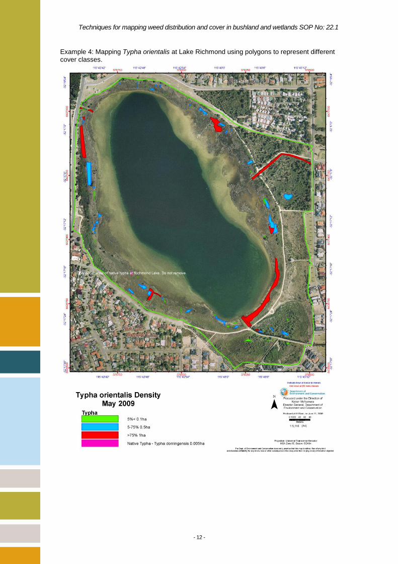
Example 4: Mapping Typha orientalis at Lake Richmond using polygons to represent different cover classes.

Techniques for mapping weed distribution and cover in bushland and wetlands SOP No: 22.1
- 13 -
Example 5: An illustration of how mapping of covers classes can be used to record change in cover of Perennial Veld Grass at Shenton Bushland over four years. Red = 71-100% cover Blue = 6-70% cover Green = < 5% cover
1999 2000
2001 2002
Techniques for mapping weed distribution and cover in bushland and wetlands SOP No: 22.1
- 14 -
5.5 Producing maps and storing data
Once weed mapping data has been collected it should be presented in map form and the data stored securely and in a format that is accessible to others across the region. GIS is software that is designed to modify, display, query and analyse the weed mapping data collected using a GPS and can be used to generate maps and reports. It is important that your GPS is able to record and export spatial data in a format that is compatible with the GIS system you are using. Examples of GIS software include: ArcGIS; MapInfo; CAD; and DECGIS. Maps can be produced in a range of styles and formats, however there are key elements that need to be included in a map to make it useful. Include a title with the site location and/or weed species and date the mapping was undertaken. The legend should explain all the graphic elements of the map including weed species, cover classes, roads, waterways, tenure, vegetation overlays, etc. Also include a scale bar, north arrow, graticule or grid marks with a coordinate system, the date the map was produced and the map author. Refer to the DEC Map Production Tool for generating simple and standard departmental maps (available through ArcGIS). The management of the collected spatial data, including file naming conventions, directory structure, and storage and creation of metadata is addressed in SOP 1.4 File Management: Naming convention, directory structure, storage and creation of metadata for spatial and spatial data and this can be found at: (http://www.dec.wa.gov.au/component/option,com_docman/task,doc_download/gid,4019/Itemid)
Note: when a weed species is recorded at a particular reserve as both points and cover classes (polygons), on the same day, it will be necessary to indicate the data type in the naming of the shapefiles, e.g. Euphorbia_terracina_Paganoni_20100702_point.shp and Euphorbia_terracina_Paganoni_20100702_poly.shp
A project area has been created on \\kens-gis-063\SharedData\WeedData and this is where all checked, final versions of collected weed data should reside according to the following protocol: WeedData Goldfields Kimberley Midwest Pilbara South_Coast South_West
Swan
Reserve#_name (i.e. the first reserve that you collect weeds info for e.g. R39822_LanePool)
species_reserve_YYYYMMDD.shp species_reserve_ YYYYMMDD.shp (e.g.
Watsonia_LanePool_20100819.shp) …
…more datasets named according to this standard (from SOP 1.4)
Reserve#_name (another reserve that you collect weeds info for etc.)
species_reserve_ YYYYMMDD.shp species_reserve_ YYYYMMDD.shp …
…more datasets named according to this standard (from SOP 1.4)
Etc. etc.
Warren Wheatbelt
Techniques for mapping weed distribution and cover in bushland and wetlands SOP No: 22.1
- 15 -
Metadata needs to be created for these datasets as well and this is outlined in section 6.4 of SOP 1.4. A key requirement outlined in SOP 1.4 is for data collectors to utilise either DECgis or ArcGIS to create metadata about the shapefiles. This metadata lives alongside the shapefiles in the above directory structure.
The metadata should also be regularly placed in the corporate records system according to the SOP 1.4 section 6.5.
ONLY SHAPE FILES SHOULD BE STORED IN THE ABOVE DIRECTORY STRUCTURE. Digital versions of completed maps as PDF's or Jpegs should be named following SOP No. 1.4 and stored in a separate directory on the shared T drive. Hardcopies of maps should be placed in the relevant corporate files.
Note: A "shapefile" is actually a set of several files. Three individual files are mandatory to store the core data that comprises a shapefile: ".shp", ".shx", ".dbf". Metadata file “.shp.xml” will be also
required to be included with any shapefile data.
5.6 Using weed maps
Weed maps and information collected are useful in a number of ways. They allow for:
1. Strategic control work and protecting the good bushland: Maps of individual weed species enable targeted control work and protection of priority areas from weed invasion. By overlaying maps of individual weed species onto a bushland condition map, weed control strategies can be developed that aim to protect the least disturbed bushland. For example, small isolated patches of serious weeds in relatively undisturbed bushland can be identified and listed as a high priority for control.
2. Understanding the distribution of weeds in bushland: Overlaying weed maps onto vegetation maps can highlight relationships between weed species and particular plant communities.
3. Monitoring the spread of established weeds and the effectiveness of control programs: Weed maps provide a useful tool for monitoring the establishment and spread of weeds. Mapping weed distribution and cover prior to beginning any control program and then mapping in subsequent years will provide an indication of the program‟s effectiveness. If no control is being undertaken then maps can provide general information on the rate of spread over time and whether or not a particular weed is moving away from disturbed areas into good bushland. Weed maps can also highlight the main direction of spread, such as along tracks, with prevailing winds or in sheet water flow.
4. Setting priorities and developing works programs: Having an accurate picture of the distribution of the weeds at a bushland site can help set priorities and develop work programs. The information generated allows isolated populations of weeds in good bushland to be targeted, highlight infestations appropriate for hand-weeding and dense infestations that may require spraying. The maps provide information on proximity to waterways and may highlight potential problems for control such as contamination or erosion.

Techniques for mapping weed distribution and cover in bushland and wetlands SOP No: 22.1
- 16 -
6 Competencies and Approvals
Table 1: Competency requirements for mapping weed distribution and cover in bushland and wetlands.
Competency Category Competency
Requirement Competency Assessment
DEC Weed Management and Natural Area Restoration Course
Completion of DEC Weed Management and Natural Area Restoration course is desired
Officer should be able to correctly identify weed and native species, confident in estimating vegetation cover, competent in the use of GPS equipment
7 Occupational Health and Safety
It is recommended a job safety analysis relevant to the task is undertaken at the site before you
begin mapping. As a guide, a safety analysis associated with working in bushland
environments should include consideration of:
Exposure to sun
Potential trip or fall injury
Dangerous fauna
Driving (4x4 drive or light vehicle)
Dehydration and
Disorientation, working under canopy, SARS procedure.
8 Further Reading
The following SOPs have been mentioned in the advice regarding creation of metadata for weed maps:
SOP 1.4 File Management: Naming convention, directory structure, storage and creation of metadata for spatial and spatial data
9 References
Brown, K. & Brooks, K. (2002), Bushland Weeds: A Practical Guide to Their Management.
Environmental Weeds Action Network, Greenwood, WA.
McNaught, I., Thackway, R., Brown, L. and Parsons, M. (2006), A field manual for surveying and
mapping nationally significant weed. Bureau of Rural Sciences, Canberra.

Techniques for mapping weed distribution and cover in bushland and wetlands SOP No: 22.1
- 17 -
10 Appendix 1 Manual recording template—Minimum data collection for weed mapping
Date (date of observation)
Scientific Name of weed mapped
Officers (name of officers
involved in data collection)
Reserve name (include
reserve number if available)
Location (optional field) Description of location
of feature in landscape that relate to finding the weed
Specimen Voucher Number (See
Herbarium Collecting Sheet)
Data Capture Method (GPS, DGPS or
other, please specify, e.g. manual mapping)
How weed populations are mapped? Individual plants? Cover classes?
If cover, specify cover classes used. (Recommended: 1= less than 5%; 2 = 6-75%, 3 = 76-100%)
Comments (any comments
related to the weed or data capture)

Techniques for mapping weed distribution and cover in bushland and wetlands SOP No: 22.1
- 18 -
11 Appendix 2 Herbarium Collecting Sheet - suggested form to complete and submit with a
voucher collection for the WA Herbarium
This form is available from: http://www.dec.wa.gov.au/images/stories/nature/science/herbarium/herbarium_collecting_sheet.pdf

Techniques for mapping weed distribution and cover in bushland and wetlands SOP No: 22.1
- 19 -
12 Appendix 3 Example of a metadata statement

Techniques for mapping weed distribution and cover in bushland and wetlands SOP No: 22.1
- 20 -