Embed Size (px)
Citation preview
Agronomy 105 1
SOILS IN THE FIELD Characteristics of the soil are important factors to consider when deciding how land can best be used. Much can be learned about suitability for grain production, pasture, home or industrial construction, roadways, and other uses by carefully examining soil reports and critically evaluating the soil's characteristics. To be able to describe a soil, one must be familiar with terms such as soil profile, color, texture, structure, and horizons. With practice one can look at a soil profile and relate its characteristics to yield potential, drainage problems, water holding capacity for crop growth, erodibility and many other factors. Management decisions concerning what type of crop will grow best on a particular soil, the environmental consequences of tillage methods, when one should plant, or suitability of soil for home sites or industrial uses can be aided by a basic knowledge of soil. Examining soils in the field provides a perspective of how the soil fits into and interrelates with the total environment. Use the following study guide to help you understand the major objectives at each of the stops.
Soil pores and water movement All soils contain pore spaces, which is the total continuous and interconnecting void space in the bulk volume of soil, of various sizes. Micropores are so small (<50 nm in diameter) they restrict air movement. Water moves in micropores by capillary action, which is water being naturally attracted into small openings, some as tiny as the diameter of a hair. Macropores, pores in the soil created by such agents as plant roots, soil cracks, or soil fauna are large enough (≥50 nm) to allow rapid movement of water into their larger spaces. Large volumes of water can travel through macropores very quickly, resulting in rapid infiltration rates. Water infiltration can be very high when soil macropores extend all the way to the soil surface. This results as an increase in water entering the soil profile instead of running off like it would with no macropores to absorb it. Reduction in soil erosion is a benefit of
Objectives: Use a soil survey report to locate
a farm, determine soil type, and explain the soil's characteristics.
Recognize how soil texture affects crop production.
Define macropore, micropore and capillary action.
Describe the relationship between soil texture and plant available water.
Describe how soil macropores are created and destroyed, and recognize their impact on drainage.
Recognize the principles of tile drainage.
Identify soil horizons and characteristics
Demonstrate how vegetative cover affects soil temperature.
List factors involved with soil erosion.
Soils in the Field Objectives Soil pores and water quality Soil texture and plant available water Tile drainage The Revised Universal Soil Loss Equation Definitions Field Trip Study Guide
Agronomy 105 2
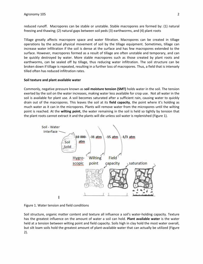
reduced runoff. Macropores can be stable or unstable. Stable macropores are formed by: (1) natural freezing and thawing; (2) natural gaps between soil peds (3) earthworms, and (4) plant roots Tillage greatly affects macropore space and water filtration. Macropores can be created in tillage operations by the actual physical movement of soil by the tillage equipment. Sometimes, tillage can increase water infiltration if the soil is dense at the surface and has few macropores extended to the surface. However, macropores formed as a result of tillage are often unstable and temporary, and can be quickly destroyed by water. More stable macropores such as those created by plant roots and earthworms, can be sealed off by tillage, thus reducing water infiltration. The soil structure can be broken down if tillage is repeated, resulting in a further loss of macropores. Thus, a field that is intensely tilled often has reduced infiltration rates. Soil texture and plant available water Commonly, negative pressure known as soil moisture tension (SMT) holds water in the soil. The tension exerted by the soil on the water increases, making water less available for crop use. Not all water in the soil is available for plant use. A soil becomes saturated after a sufficient rain, causing water to quickly drain out of the macropores. This leaves the soil at its field capacity, the point where it’s holding as much water as it can in the micropores. Plants will remove water from the micropores until the wilting point is reached. At the wilting point, the water remaining in the soil is held so tightly by tension that the plant roots cannot extract it and the plants will die unless soil water is replenished (Figure 1).
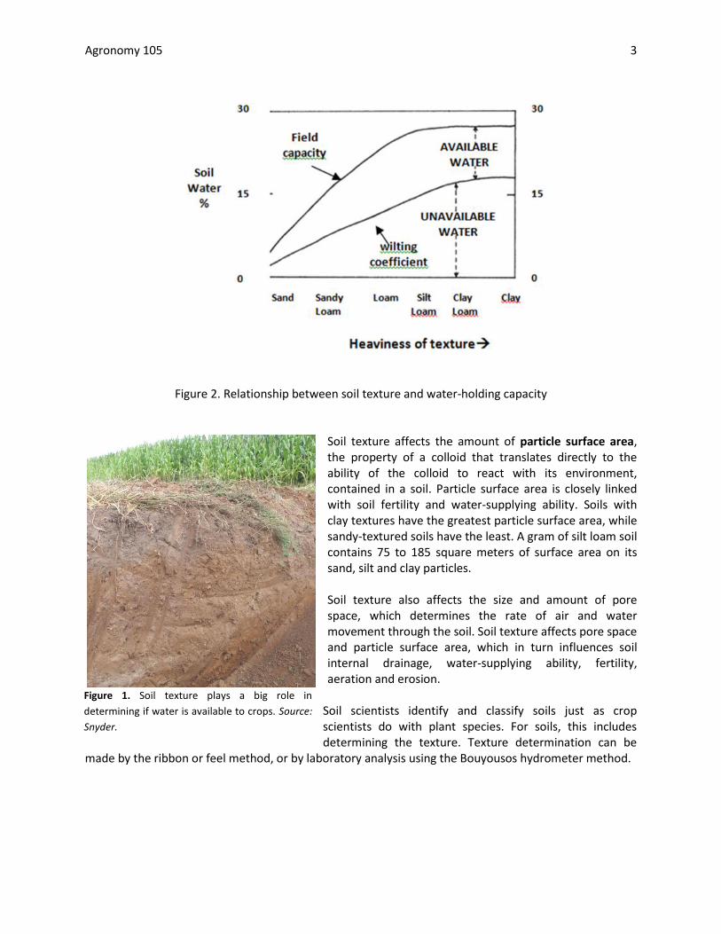
Figure 1. Water tension and field conditions Soil structure, organic matter content and texture all influence a soil’s water-holding capacity. Texture has the greatest influence on the amount of water a soil can hold. Plant available water is the water held at a tension between wilting point and field capacity. Soils high in clay hold the most water overall, but silt loam soils hold the greatest amount of plant-available water that can actually be utilized (Figure 2).
Agronomy 105 3
Figure 2. Relationship between soil texture and water-holding capacity
Soil texture affects the amount of particle surface area, the property of a colloid that translates directly to the ability of the colloid to react with its environment, contained in a soil. Particle surface area is closely linked with soil fertility and water-supplying ability. Soils with clay textures have the greatest particle surface area, while sandy-textured soils have the least. A gram of silt loam soil contains 75 to 185 square meters of surface area on its sand, silt and clay particles. Soil texture also affects the size and amount of pore space, which determines the rate of air and water movement through the soil. Soil texture affects pore space and particle surface area, which in turn influences soil internal drainage, water-supplying ability, fertility, aeration and erosion.
Soil scientists identify and classify soils just as crop scientists do with plant species. For soils, this includes determining the texture. Texture determination can be
made by the ribbon or feel method, or by laboratory analysis using the Bouyousos hydrometer method.
Figure 1. Soil texture plays a big role in
determining if water is available to crops. Source:
Snyder.

Agronomy 105 4
Tile drainage Systems of underground clay, cement or perforated plastic tubing tile are designed to remove excess water from crop fields, and they usually provide an effective means of improving soil drainage. Regardless of what material the tile is made from, they all function by the same principles. The tile is usually placed one meter below the soil surface. However, the tile line spacing varies depending on soil type (Table 1). Water moves from the surrounding soil to the tile, enters through perforations in the tubing or through open joints between the tiles, and then moves through the tile to an outlet ditch.
Table 1. Suggested spacing between tile laterals for different soil and permeability conditions.
Soil Permeability Spacing between tile lines(feet)
Clay & clay loam Very slow 30-60 Silt & silty clay loam Slow to moderately slow 60-100 Sandy loam Moderately slow to rapid 100-300 Much & peat Slow to rapid 50-200
Advantages of improved soil drainage include warmer soil temperatures in the spring, better soil aeration, more days to perform field operations with heavy machinery, and the reduced risk of soil heaving. Characteristics of the soil are important factors to consider when deciding how land can be best used. Suitability for grain production, pasture, home or industrial construction, roadways, and other uses can be learned by carefully examining soil reports and critically evaluating the soil’s characteristics. Terms such as soil profile, color, texture, structure and horizons can be used to describe
a soil. With practice, one can look at a soil profile and relate its characteristics to yield
potential, drainage problems, water holding capacity and erodibility. A basic knowledge of soil can help determine management decisions of what crops will grow best on a particular soil, the environmental consequences of tillage methods, when planting should occur, and the suitability of soil for home sites or industrial uses.
Figure 2. Installation of tile can improve soil drainage
Agronomy 105 5
The Revised Universal Soil Loss Equation:
A =R x K x LS x C x P How does each of the factors in the Revised Universal Soil Loss Equation contribute to the amount of soil loss? The Rainfall (R) factor represents potential erosion based upon an area’s seasonal distribution, intensity and total rainfall. The Soil Erodibility (K) factor deals with the actual soil type. Infiltration capacity and structural stability are considered in determining this factor. These properties are affected by the soil texture and organic matter content, as well as several other characteristics. The Length and Steepness (LS) of the slope is important in determining the soil loss because a greater degree incline will increase the velocity of the water, giving it more force to detach soil particles. An increase in the length of slope will provide a greater volume of flooding water, which also affects soil detachment. When the Crop Management (C) factor is not considered, one is determining annual soil loss on bare soil. The crop management factor is based upon the type of crop planted in an area (some crops are better than others at holding soil in place) and the cropping system used. The Erosion Control (P) factor shows the effect of using different tillage systems as well as other conservation practices, such as terracing or contour cropping.
"T" is the maximum soil erosion loss that a soil can tolerate and still maintain its productivity
over time. The process of soil development can keep pace with losses if erosion is less than
this. For many soils, this value is 5 tons/acre/year. For a specific soil, refer to the charts in the
county soil survey book.
Example: Central Indiana farm, well-drained prairie soil, 4% slope 600 ft. long, conventional
tillage, corn/soybean rotation without conservation practices
A = 180 x 0.41 x 0.82 x 0.25 x 1 = 15.1 Tons/Acre/Year…… YIKES!!
By using no-till planting the C factor is reduced to 0.11, and by using contouring the P factor is
reduced to 0.5. Adoption of these two practices would have the following result:
A = 180 x 0.41 x 0.82 x 0.11 x 0.5 = 3.3 Tons/Acre/Year…… MUCH BETTER
Acceptable!
*

Agronomy 105 6
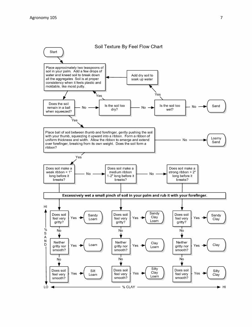
Soil Texture: the proportions of different sized mineral particles in the soil or the relative
amount of sand, silt, and clay present in the soil expressed as percentages.
There are 12 textural class categories.
To determine soil texture: Moisten a sample of the soil and squeeze it out between the
thumb and forefinger and try to form a ribbon.
First, if the soil is……. o Extremely sticky and stiff it is one of the clays o Sticky and stiff the squeeze it is one of the clay loams o Soft, easy to squeeze, and only slightly sticky it is one of the loams
We add an adjective , if the soil is: o Very smooth, we use silt or silty o Somewhat gritty, we use no adjective o Very gritty, we use sandy
Particle size limits:
Sand: 2.0-0.05 mm
Silt: 0.05-0.002
Clay < 0.002 mm
Agronomy 105 7
Agronomy 105 8
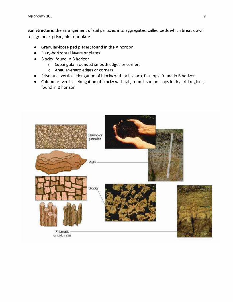
Soil Structure: the arrangement of soil particles into aggregates, called peds which break down
to a granule, prism, block or plate.
Granular-loose ped pieces; found in the A horizon
Platy-horizontal layers or plates
Blocky- found in B horizon o Subangular-rounded smooth edges or corners o Angular-sharp edges or corners
Prismatic- vertical elongation of blocky with tall, sharp, flat tops; found in B horizon
Columnar- vertical elongation of blocky with tall, round, sodium caps in dry arid regions; found in B horizon
Agronomy 105 9
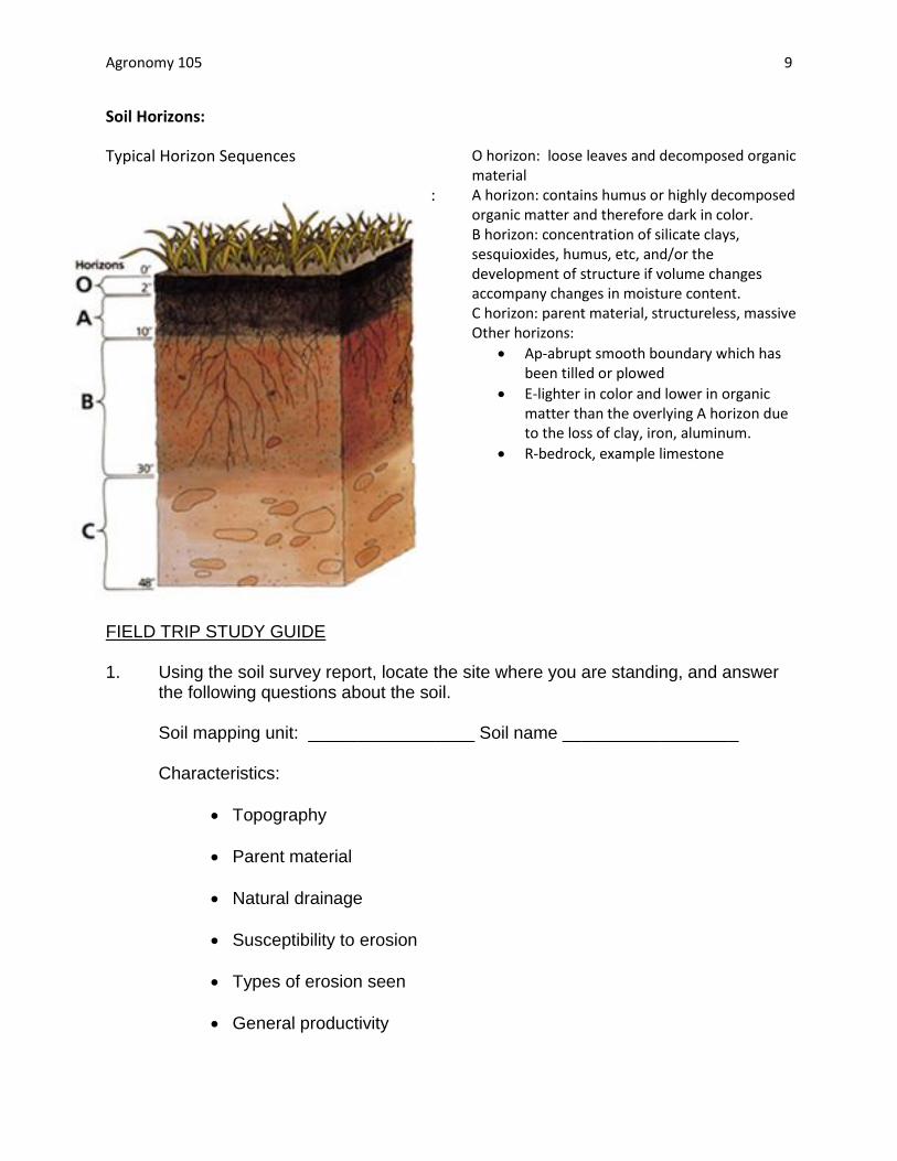
Soil Horizons:
Typical Horizon Sequences
:
FIELD TRIP STUDY GUIDE 1. Using the soil survey report, locate the site where you are standing, and answer
the following questions about the soil.
Soil mapping unit: _________________ Soil name __________________ Characteristics:
Topography
Parent material
Natural drainage
Susceptibility to erosion
Types of erosion seen
General productivity
O horizon: loose leaves and decomposed organic material A horizon: contains humus or highly decomposed organic matter and therefore dark in color. B horizon: concentration of silicate clays, sesquioxides, humus, etc, and/or the development of structure if volume changes accompany changes in moisture content. C horizon: parent material, structureless, massive Other horizons:
Ap-abrupt smooth boundary which has been tilled or plowed
E-lighter in color and lower in organic matter than the overlying A horizon due to the loss of clay, iron, aluminum.
R-bedrock, example limestone
Agronomy 105 10
2. Examine the soil profile and answer the following questions:
How many horizons can you see?
What are they?
At what depth are they?
What is the color of the A horizon?
What is the predominant color of the B horizon? Is there any mottling? What type of drainage does mottling indicate? How does soil texture differ between the A and B horizons? Which horizon has the greatest clay content?
How does structure differ between horizons? What type of structure do you see in the A horizon? What type of structure do you see in the B horizon?
Agronomy 105 11
3. After examining the soil at this location, what are desirable and undesirable factors for each of the following land uses:
row crop production home sites road construction permanent pasture 4. How does the surface temperature of the soil at the location with soil cover differ
from the location without soil cover? Factors which affect soil temperature are: Would the present soil temperature be desirable for:
Corn germination
Weed seed germination
Organic matter decomposition
Root growth What could the farmer to do encourage desirable soil temperature for crops
being grown?
Agronomy 105 12
Definitions
Capillary action: water being naturally attracted into small openings Field capacity: the point at which a soil becomes saturated with water Horizon: layer of soil with somewhat uniform color, texture, and structure. Macropores: pores in the soil large in diameter (more than 50 nm), created by such agents as plant roots, soil cracks, or soil fauna; macropores increase the hydraulic conductivity of the soil, allowing water to infiltrate faster or for shallow groundwater to flow faster Micropores: pores within the soil less than 50 nm in diameter that tends to restrict air movement; water moves between them by capillary action Particle surface area: the property of a colloid that translates directly to the ability of the colloid to react with its environment
Plant available water: water held at a tension between wilting point and field capacity Pore space: the total continuous and interconnecting void space in the bulk volume of soil Soil Moisture Tension (SMT): the tension on water due to negative pressure put on it by soil; as water availability decreases, water and soil contact decreases, and tension by the soil on water increases Soil Profile: vertical section of soil extending down from the surface and exposing the underlying layers of development. Tile: clay, cement or perforated plastic tubing that is placed under soil surface to improve soil drainage Wilting point: the point at which water remaining in the soil is so tightly held by tension, that plant roots cannot extract it

13
Soils in the Lab
Stoke’s Law The Bouyoucos hydrometer method of determining soil texture measures the concentration of soil particles in suspension at a given time, and depends on the rate of settling of sand, silt and clay. This method is based on Stoke’s Law, which says large soil particles will settle out of suspension faster than smaller particles, because large particles have less surface area in proportion to their weight than do small particles. Sand will settle out first, followed by silt, and finally, under certain conditions, clay. The hydrometer, a sealed, graduated tube used as a measure of the fluid's specific gravity indicates the density of the sand, silt and/or clay suspension. The density of the suspension becomes less as more material settles out of the suspension.
The hydrometer is calibrated to give a reading directly in grams of material in suspension per liter of suspension (g/L). Soil particles tend to cling together due to the effect of organic and inorganic colloidal material, gelatinous or mucinous substance, inorganic cementing materials, etc. For accurate results of any mechanical analysis, the particles must be thoroughly dispersed with a chemical dispersing agent such as sodium hexametaphosphate.
Objectives: Define soil texture and
structure. Mechanically analyze soil
texture using the
Bouyoucos Method. Given the percent of
sand, silt and clay in a soil, use a textural triangle to place the soil in the correct textural class.
Use the soil survey book to locate information about soil properties on the farm.
Analyze soil texture by feel.
Soils in the Lab Objectives Stoke's Law The textural triangle Soil texture and soil structure Experimental procedure Results Definitions Questions
14
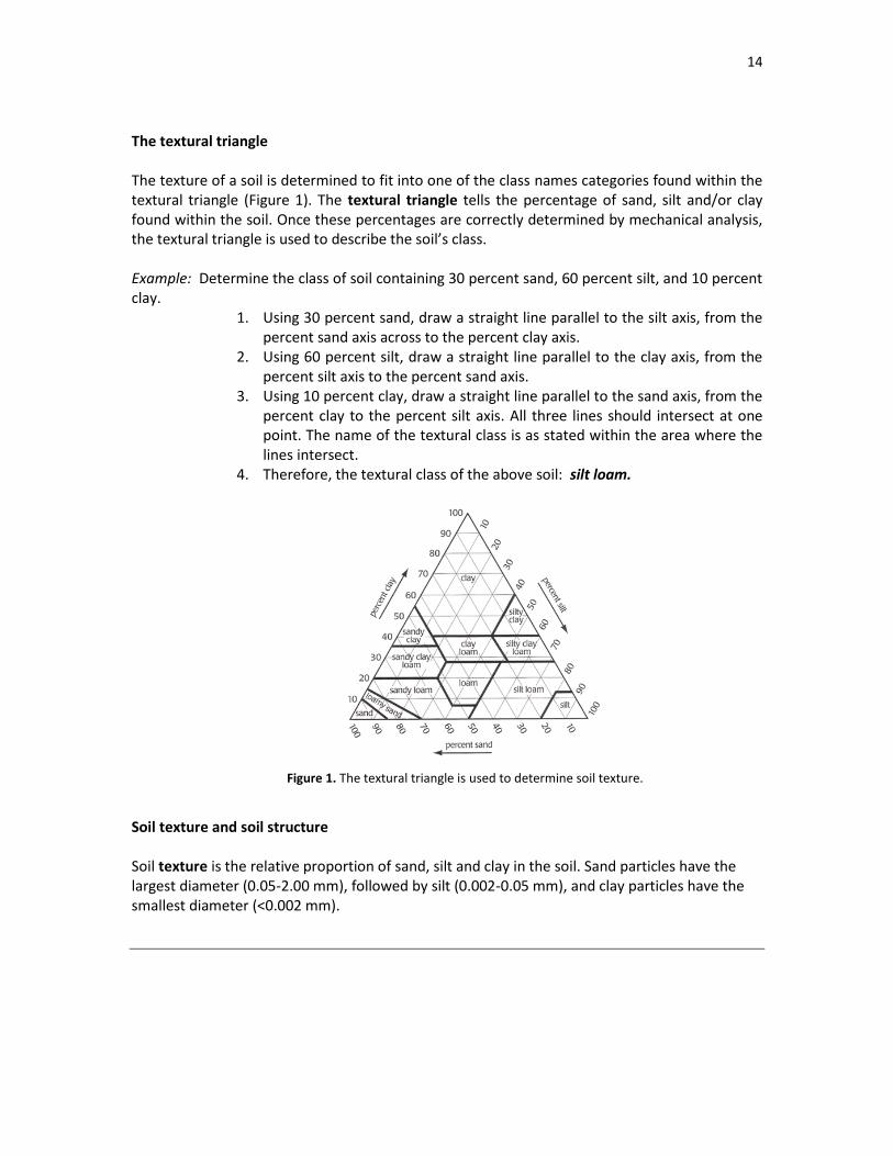
The textural triangle The texture of a soil is determined to fit into one of the class names categories found within the textural triangle (Figure 1). The textural triangle tells the percentage of sand, silt and/or clay found within the soil. Once these percentages are correctly determined by mechanical analysis, the textural triangle is used to describe the soil’s class. Example: Determine the class of soil containing 30 percent sand, 60 percent silt, and 10 percent clay.
1. Using 30 percent sand, draw a straight line parallel to the silt axis, from the percent sand axis across to the percent clay axis.
2. Using 60 percent silt, draw a straight line parallel to the clay axis, from the percent silt axis to the percent sand axis.
3. Using 10 percent clay, draw a straight line parallel to the sand axis, from the percent clay to the percent silt axis. All three lines should intersect at one point. The name of the textural class is as stated within the area where the lines intersect.
4. Therefore, the textural class of the above soil: silt loam.
Soil texture and soil structure Soil texture is the relative proportion of sand, silt and clay in the soil. Sand particles have the largest diameter (0.05-2.00 mm), followed by silt (0.002-0.05 mm), and clay particles have the smallest diameter (<0.002 mm).
Figure 1. The textural triangle is used to determine soil texture.
15
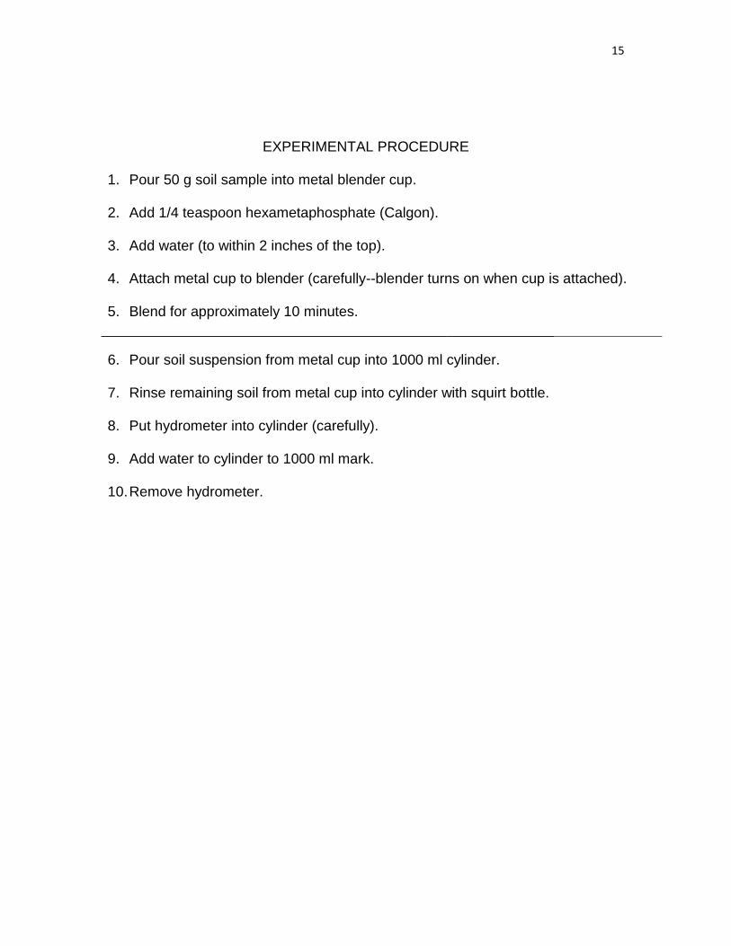
EXPERIMENTAL PROCEDURE 1. Pour 50 g soil sample into metal blender cup.
2. Add 1/4 teaspoon hexametaphosphate (Calgon).
3. Add water (to within 2 inches of the top).
4. Attach metal cup to blender (carefully--blender turns on when cup is attached). 5. Blend for approximately 10 minutes.
6. Pour soil suspension from metal cup into 1000 ml cylinder. 7. Rinse remaining soil from metal cup into cylinder with squirt bottle. 8. Put hydrometer into cylinder (carefully).
9. Add water to cylinder to 1000 ml mark.
10. Remove hydrometer.
16
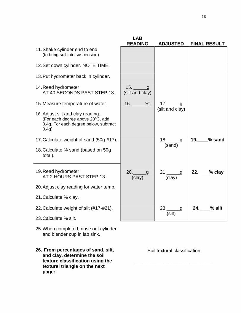
LAB READING
ADJUSTED
FINAL RESULT
11. Shake cylinder end to end (to bring soil into suspension)
12. Set down cylinder. NOTE TIME.
13. Put hydrometer back in cylinder.
14. Read hydrometer AT 40 SECONDS PAST STEP 13.
15. _____g (silt and clay)
15. Measure temperature of water.
16. Adjust silt and clay reading. (For each degree above 20ºC, add 0.4g. For each degree below, subtract 0.4g)
16. _____ºC 17._____g (silt and clay)
17. Calculate weight of sand (50g-#17).
18. Calculate % sand (based on 50g total).
18._____g (sand)
19.____% sand
19. Read hydrometer AT 2 HOURS PAST STEP 13.
20. Adjust clay reading for water temp.
21. Calculate % clay.
20._____g
(clay)
21._____g
(clay)
22.____% clay
22. Calculate weight of silt (#17-#21).
23. Calculate % silt.
23._____g (silt)
24.____% silt
25. When completed, rinse out cylinder and blender cup in lab sink.
26. From percentages of sand, silt, and clay, determine the soil texture classification using the textural triangle on the next page:
Soil textural classification
______________________________

17
Definitions Adhesion: attraction of molecules to unlike surfaces.
Aeration: the movement of air into and out of pore space in a soil.
Available water: water which plant roots are able to take up and use.
Bouyoucos Method: using a hydrometer to determine soil texture by measuring the concentration of soil particles at a given time, depending on the rate of settling of sand, silt and clay.
Capillary rise: the attraction of water into openings of the approximate diameter of a hair, wick action.
Cohesion: attraction of like molecules to one another.
Colloidal Material: gelatinous or mucinous substance, inorganic cementing materials, etc.
Clay: soil particles less than .002 mm in diameter.
Field Capacity: condition when water is thought to be most available to plants, held with 1/3 atmosphere of tension.
Gravitational Water: held with less than 1/3 atmosphere of tension; drains from soil profile by gravity.
Horizon: layer of soil with somewhat uniform color, texture, and structure.
Hydrometer: a sealed, graduated tube, weighted at one end that sinks in a fluid to a depth used as a measure of the fluid's specific gravity.
Hygroscopic Water: water held so tightly to soil colloids that it is unavailable to plants.
Infiltration: movement of water into a soil.
Inorganic Soil Component: composed of weathered mineral matter.
Macropores: pores large enough to allow rapid movement of water.
Micropores: pores small enough to restrict air movement: water moves by capillary action in micropores.
Organic Soil Component: composed of organic residues, plants, and animals.
Percolation: movement of water though the soil.
Pore Space: space between soil particles which can be occupied by air and water.
Profile: vertical section of soil extending down from the surface and exposing the underlying layers of development.
Sand: soil particles larger than 0.05 mm, which provides coarse characteristics to the soil.
Silt: soil particles between 0.05 – 0.002 mm, which feels smooth and floury when wet.
Soil aggregate: a group of soil particles bound together by organic matter .
Stoke’s Law: an equation relating the terminal settling velocity of a smooth, rigid sphere in a viscous fluid of known density and viscosity to the diameter of the sphere.
Structure: arrangement of soil particles; ex: prismatic, subangular blocky etc.
Textural triangle: a map used to determine soil texture based on percentages of sand, silt and clay within the soil
Texture: the relative proportion of sand, silt and clay in the soil
Unavailable Water: water held by the soil into aggregates with so much tension that plants cannot use it
18
Questions
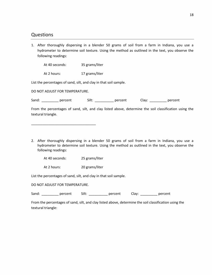
1. After thoroughly dispersing in a blender 50 grams of soil from a farm in Indiana, you use a
hydrometer to determine soil texture. Using the method as outlined in the text, you observe the
following readings:
At 40 seconds: 35 grams/liter
At 2 hours: 17 grams/liter
List the percentages of sand, silt, and clay in that soil sample.
DO NOT ADJUST FOR TEMPERATURE.
Sand: _________ percent Silt: __________ percent Clay: _________ percent
From the percentages of sand, silt, and clay listed above, determine the soil classification using the
textural triangle.
__________________________________
2. After thoroughly dispersing in a blender 50 grams of soil from a farm in Indiana, you use a hydrometer to determine soil texture. Using the method as outlined in the text, you observe the following readings:
At 40 seconds: 25 grams/liter
At 2 hours: 20 grams/liter
List the percentages of sand, silt, and clay in that soil sample.
DO NOT ADJUST FOR TEMPERATURE.
Sand: _________ percent Silt: __________ percent Clay: _________ percent
From the percentages of sand, silt, and clay listed above, determine the soil classification using the
textural triangle:

19
3. The container filled with layers of silt and sand simulates a stratified soil profile and has been field
according to the diagram below
As the water moves through the soil observe the wetting front movement. Notice any change that
occurs when the wetting front reaches the stratified layer.