Embed Size (px)
Citation preview

WCTIS Phase 2 M5 J11 to Arle Court Improvement Scheme SDI Appraisal Page 1 of 57
Social and Distributional Impact Assessment
Technical Note
Project: WCTIS, Phase 2
Subject: Social and Distributional Impacts
Author: ER
Date: 04/10/2019 Project No.: 5188734
Atkins No.: Icepac No.:
Distribution: Representing:
Document history
Revision Purpose description Origin-ated
Checked Reviewed Authorised Date
Rev 1.0 Social and Distributional Impacts
ER <initials> <initials> 04/10/2019
Client signoff
Client Gloucestershire County Council
Project WCTIS, Phase 2
Project No. 5188734
Client signature / date
WCTIS Phase 2 M5 J11 to Arle Court Improvement Scheme SDI Appraisal Page 2 of 57
Social and Distributional Impact Assessment
1. Introduction
This technical note details the findings of a Social and Distributional Impact (SDI) Appraisal undertaken for the West of Cheltenham Transport Improvement Scheme (WCTIS) Phase 2 – M5 J11 to Arle Court. The overall scheme is the second of four phases proposed as part of the West of Cheltenham Improvement Package. The A40 currently experiences significant delays and congestion for traffic travelling inbound and outbound to/from Cheltenham. This congestion would be exacerbated with additional development in the area such as development at West Cheltenham (CyberPark), and so it is essential to provide additional capacity on this key route. The location of the WCTIS Phase 2 scheme is shown in Figure 1-1.
In order to provide the additional capacity, the scope of Phase 2 comprises the following components. This has been subject to traffic modelling and assessment during the design phase to confirm the preferred layouts:
• A40 eastbound merge from M5 Junction 11 upgraded to a lane gain with ghost island merge; and
• A40 eastbound carriageway upgraded to three lanes from the new lane gain eastbound to Arle Court Roundabout.
Figure 1-1 Scheme Location
The key transport objectives of the WCTIS Phase 2 Improvement Scheme are to;
• Contribute to accelerating the release of the employment land associated with the ‘West Cheltenham’ Strategic Allocation along with the other strategic allocations in the JCS adjacent to GCHQ, which includes the proposed Cyber Park and Cyber Innovation Centre;
• Deliver transport benefits to people living and working in Gloucestershire by improving traffic flows on the A40, one of the most important and busiest sections of Gloucestershire’s road network;

WCTIS Phase 2 M5 J11 to Arle Court Improvement Scheme SDI Appraisal Page 3 of 57
Social and Distributional Impact Assessment
• Aim to have an overall neutral impact on the Cheltenham Air Quality Management Area (AQMA);
• Maintain and improve the options for sustainable travel modes through the junction and on the approaches; walking, cycling, and where feasible providing for enhanced public transport facilities.
1.1. SDI Process
Social impacts consider the overall impact of transport interventions on different indicators, while Distributional Impacts (DIs) consider the variance of impacts across different social groups. The analysis of SDIs is mandatory in the appraisal process and undertaken in accordance with WebTAG guidance Unit A4.1 and A4.2 and is a constituent of the Appraisal Summary Table (AST). Both beneficial and/or adverse SDIs of transport interventions are considered, along with the identification of social groups likely to be affected.
The indicators considered for social or distributional impacts are shown in Table 1-1.
Table 1-1 Indicators considered for social and distributional impacts
Indicator Social Impact Distributional Impact
User Benefits
Air Quality
Noise
Personal Security
Severance
Accessibility
Personal Affordability
Accidents
Physical Activity
Journey Quality
Option Values and Non-Use Values
The DI process involves the following three stages (see Table 1-2 overleaf):
• Screening;
• DI Assessment;
• Appraisal of Impacts
Table 1-2 DI Process
Step Description Output
Screening 1 Identification of likely impacts for each indicator
Screening Proforma
Full appraisal 2 Assessment:
• Confirmation of the area impacted by the transport intervention (impact area)
• Identification of social groups in the impact area (such as transport users, people living in those areas affected by the scheme)
• Identification of amenities in the impact area
DIs social groups statistics and amenities affected within the impact area
3 Appraisal of impacts: Appraisal tables and AST Inputs
WCTIS Phase 2 M5 J11 to Arle Court Improvement Scheme SDI Appraisal Page 4 of 57
Social and Distributional Impact Assessment
Core analysis of the impacts (including providing an assessment score for each indicator based on the following seven-point scale:
• large beneficial (✓✓✓)
• moderate beneficial (✓✓)
• slight beneficial (✓)
• neutral (0)
• slight adverse ()
• moderate adverse ()
• large adverse ()
Full appraisal of DIs and input into AST
Section 3 of this technical note details the outcome of the DI appraisal undertaken on the required indicators for the scheme.
1.1.1. Assessment A quantitative analysis of user benefits and affordability has been undertaken using outputs from the 60-year appraisal from TUBA. In order to ensure the level of detail is proportionate for this stage in the scheme design a qualitative analysis has been undertaken for each of the other screened-in indicators.
Vehicle flow and speed outputs from the Paramics microsimulation model have been used to inform the qualitative assessments. The Average Annual Daily Traffic (AADT) was calculated from the average link flow over the morning and evening peak hours. Since data is not currently available on the proportion of daily traffic which passes through the network in each peak, this assessment assumes this value to be a tenth across the whole network. Links with greater than 10% change in AADT as a result of the scheme are shown in Figure 1-2.
The limitations of using this method to calculate the AADT is that only vehicles that travel on a link in the peak hour are recorded, rather than the demand on a link. Therefore, vehicles queueing at the end of the peak hour are not recorded, causing a distortion to the AADT value. An aim of the WCTIS Phase 2 scheme is to reduce congestion in the area. Reduced congestion will result in more vehicles being able to travel through the network with the scheme in place within the peak hour. While all vehicles still complete journeys in congested conditions, increasing congestion will lead to increased journey times which means more vehicles may travel on links outside of the peak hour. While significant changes in the AADT are not observed with the Phase 2 scheme, further assessment of the AADT factor with and without the scheme would still be required. In order to ensure a proportionate assessment, this has not been calculated at this stage and the change in peak hour speed has been used to inform this assessment.

WCTIS Phase 2 M5 J11 to Arle Court Improvement Scheme SDI Appraisal Page 5 of 57
Social and Distributional Impact Assessment
Figure 1-2 Links with a change in AADT of greater than 10% due to the scheme
There are several links with a greater than 10% increase in traffic flow as a result of the scheme. This includes a section of the A40 eastbound within the Phase 2 extent and a section of Gloucester Road to the east of Benhall Roundabout. There are some links with greater that 10% reduction in traffic flow due to the scheme, these include the A 40 westbound through Benhall Roundabout and minor roads to the west of Cheltenham.
The average peak hour vehicle speed in mph has also been calculated to inform this assessment. Figure 1-3 shows links with greater than 10% change in traffic speed caused by the scheme.

WCTIS Phase 2 M5 J11 to Arle Court Improvement Scheme SDI Appraisal Page 6 of 57
Social and Distributional Impact Assessment
Figure 1-3 Links with a change in traffic speed of greater than 10% due to the scheme
There are few links with greater than 10% change in traffic speed as a result of the scheme. Links with a significant increase in speed include sections of the A40 eastbound within the scheme extent and sections of Cheltenham Road East northbound. This is likely due to the increased capacity along the A40 eastbound reducing congestion, meaning vehicles can travel faster along the road. This will also cause vehicles to reroute onto the improved section of the A40, causing journey times to be reduced on alternative routes. Links with a significant decrease in traffic speed include a section of Cheltenham Road East southbound and the eastbound A40 diverge to the M5 Junction 11. This is again likely due to vehicles rerouting onto the improved section of the A40, causing journey times to change on routes surrounding the scheme location. There are a significant number of links with greater than 10% change in peak hour speed on minor roads to the west of Cheltenham. Speeds on these routes are low, meaning a small change in traffic speed is greater than 10%.
The assessment of AADT and average vehicle speed are shown to be consistent in Figure 1-2 and Figure 1-3. Reduced congestion along the A40 eastbound leads to increased traffic speed in the area, meaning more vehicles are able to complete a movement. Therefore, there is increased vehicle flow and speed on these links. There is decreased traffic speed and increased vehicle flow on the A40 diverge to the M5 junction 11. This is likely due to more vehicles travelling on this link due to rerouting. Hence, congestion will increase in this area causing traffic speeds to decrease.
WCTIS Phase 2 M5 J11 to Arle Court Improvement Scheme SDI Appraisal Page 7 of 57
2. Social Impact Assessment
2.1. Accidents
2.1.1. Introduction A transport intervention can influence the number of accidents and resulting casualties. It is important to examine these changes in accidents / casualty levels as there are significant costs associated with accidents for individuals, the government and private businesses. For example, casualty costs include the suffering of individuals and families, loss of economic output and medical costs. Costs of an accident include, damage to vehicles and infrastructure, police cost, legal and insurance costs and in certain cases losses due to extended journey times and road closures.
The WCTIS Phase 2 scheme increases capacity along the A40 eastbound through a lane gain at the M5 Junction 11 merge. This will likely lead to a change in traffic flow and speed along the route which may have an impact on the number and severity of accidents in the area.
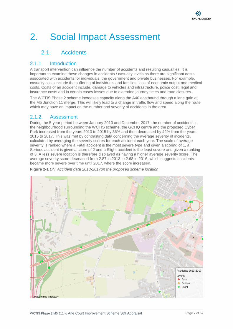
2.1.2. Assessment During the 5-year period between January 2013 and December 2017, the number of accidents in the neighbourhood surrounding the WCTIS scheme, the GCHQ centre and the proposed Cyber Park increased from the years 2013 to 2015 by 36% and then decreased by 42% from the years 2015 to 2017. This was met by contrasting data concerning the average severity of incidents, calculated by averaging the severity scores for each accident each year. The scale of average severity is ranked where a Fatal accident is the most severe type and given a scoring of 1, a Serious accident is given a score of 2 and a Slight accident is the least severe and given a ranking of 3. A less severe location is therefore displayed as having a higher average severity score. The average severity score decreased from 2.87 in 2013 to 2.68 in 2016, which suggests accidents became more severe over time until 2017, where the score increased.
Figure 2-1 DfT Accident data 2013-2017on the proposed scheme location

WCTIS Phase 2 M5 J11 to Arle Court Improvement Scheme SDI Appraisal Page 8 of 57
The map represents the DfT data for accidents that have occurred in the proposed Phase 2 area – the A40 carriageway between the M5 Junction 11 exit and Arle Court roundabout during the 5-year period between January 2013 and December 2017. The database revealed a total of 9 accidents occurring in this location. Five accidents occurred in 2013, three accidents in 2014 and six accidents in 2015. Between M5 and Junction 11 and Arle Court roundabout, seven accidents have occurred on the A40 from 2013 to 2017. Six of these accidents have a severity score of 3, indicating to be slight accidents and one accident was recorded as serious. On the M5 exit near to the A40, two accidents have occurred, both of which were determined to be slight. Below is a breakdown of the dates of the incidents, the severity of the accident, in addition to the number of casualties per accident. There are three discrete scores to categorise an accident; fatal being of the highest severity, serious the second level and slight being the lowest severity. From the table, only three incidents involved more than one casualty, with four being the highest number of casualties on 11/06/2015. Only one accident was recorded to be serious, the remaining accidents were recorded as slight.
Table 2-1 Casualties in the impact area
Date of Accident Severity Number of
Casualties
25/06/2013 3 1
06/02/2013 3 1
13/04/2013 3 1
10/06/2013 3 1
12/12/2013 3 1
12/04/2014 3 2
03/05/2014 3 1
05/11/2014 3 1
19/02/2015 3 1
17/04/2015 3 2
11/05/2015 2 3
11/06/2015 3 4
23/09/2015 3 1
08/12/2015 3 1
According to the change in AADT, there is a significant increase in speed include sections of the A40 eastbound that occur within the scheme extent. This is likely due to the increased capacity along the A40 eastbound reducing congestion, meaning vehicles can travel faster along the road. Vehicles travelling at higher speeds are more likely to result in an accident. Therefore, it is estimated there will be a slight adverse impact to accidents as a result of this scheme.
WCTIS Phase 2 M5 J11 to Arle Court Improvement Scheme SDI Appraisal Page 9 of 57
2.2. Physical Activity
2.2.1. Introduction TAG Unit 4.1 notes that transport and the physical environment of urban areas both play a major role in the amount of physical activity that people are engaged in on a day-to-day basis. There is a longstanding recognition of the interrelationship between transport, the environment and health. A 2012 meta-analysis estimated that physical inactivity was responsible for 5.3 million deaths worldwide; like that of smoking and obesity. Hence, physical activity will be assessed further in this Social Impact Assessment.
2.2.2. Assessment WebTAG Guidance Unit 4-1 requires consideration of the impacts of any travel scheme on physical activity. This is the case even if an intervention is unlikely to significantly affect active modes of travel directly, as is the case for the WCTIS Phase 2 scheme. The addition of a lane on the A40 eastbound between the M5 Junction 11 and Arle Court Roundabout may cause a modal shift away from active travel. This is due to increased capacity leading to reduced congestion and travel times. This may make private car travel a more attractive mode, leading to a mode shift from active modes to private car travel. This assessment is qualitative and based on professional judgement.
Therefore, the WCIS Phase 2 scheme may cause a decrease in travel by active modes. There are no pedestrian facilities and limited cycle facilities along the section of the A40, hence it is unlikely that a significant number of people would travel along this route by these modes. Therefore, it is assumed that there won’t be a significant mode shift away from active modes as a result of the Phase 2 upgrades. Therefore, the immediate impact of the scheme to physical activity is neutral.
WCTIS Phase 2 M5 J11 to Arle Court Improvement Scheme SDI Appraisal Page 10 of 57
2.3. Security
2.3.1. Introduction WebTAG unit A4-1 states that security concerns are greater on roads where motorists are required to slow or stop their vehicle. This includes traffic lights or congested areas. Vehicles are also vulnerable when left unattended such as in car parks or at service stations.
The widening of the carriageway in Phase 2 is likely to reduce congestion along the route hence having a potential impact to security.
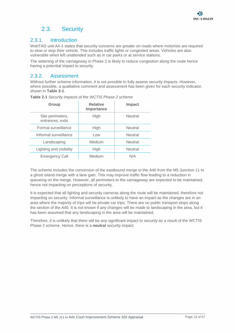
2.3.2. Assessment Without further scheme information, it is not possible to fully assess security impacts. However, where possible, a qualitative comment and assessment has been given for each security indicator, shown in Table 2-1.
Table 2-1 Security impacts of the WCTIS Phase 2 scheme
Group Relative Importance
Impact
Site perimeters, entrances, exits
High Neutral
Formal surveillance High Neutral
Informal surveillance Low Neutral
Landscaping Medium Neutral
Lighting and visibility High Neutral
Emergency Call Medium N/A
The scheme includes the conversion of the eastbound merge to the A40 from the M5 Junction 11 to
a ghost island merge with a lane gain. This may improve traffic flow leading to a reduction in
queueing on the merge. However, all perimeters to the carriageway are expected to be maintained,
hence not impacting on perceptions of security.
It is expected that all lighting and security cameras along the route will be maintained, therefore not
impacting on security. Informal surveillance is unlikely to have an impact as the changes are in an
area where the majority of trips will be private car trips. There are no public transport stops along
the section of the A40. It is not known if any changes will be made to landscaping in the area, but it
has been assumed that any landscaping in the area will be maintained.
Therefore, it is unlikely that there will be any significant impact to security as a result of the WCTIS
Phase 2 scheme. Hence, there is a neutral security impact.
WCTIS Phase 2 M5 J11 to Arle Court Improvement Scheme SDI Appraisal Page 11 of 57
2.4. Severance
2.4.1. Introduction Community severance is defined in WebTAG unit A4.1 as the separation of residents from facilities and services they use within their community caused by substantial changes in transport infrastructure, or by changes in traffic flows. The scheme includes the widening of the A40 eastbound between the M5 Junction 11 and Arle Court and a ghost island merge with lane gain at the A40 eastbound merge from M5 Junction 11.
2.4.2. Assessment Severance can be affected in two ways. The first is through physical changes to infrastructure. The second is through changes to traffic conditions. For this study speed changes of greater than 10% have been used as a proxy for severance.
There are no pedestrian facilities in the location of the Phase 2 scheme, so it is unlikely that the road widening or junction changes will have any impact to severance. However, traffic may reroute as a result of the scheme, causing changes to traffic flow and speed in the area surrounding the scheme. This could impact pedestrian’s perception of severance if they need to cross a road in order to access local amenities.
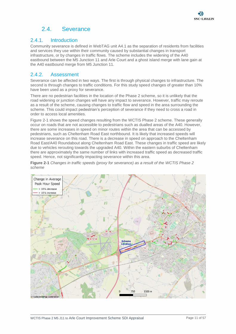
Figure 2-1 shows the speed changes resulting from the WCTIS Phase 2 scheme. These generally occur on roads that are not accessible to pedestrians such as dualled areas of the A40. However, there are some increases in speed on minor routes within the area that can be accessed by pedestrians, such as Cheltenham Road East northbound. It is likely that increased speeds will increase severance on this road. There is a decrease in speed on approach to the Cheltenham Road East/A40 Roundabout along Cheltenham Road East. These changes in traffic speed are likely due to vehicles rerouting towards the upgraded A40. Within the eastern suburbs of Cheltenham there are approximately the same number of links with increased traffic speed as decreased traffic speed. Hence, not significantly impacting severance within this area.
Figure 2-1 Changes in traffic speeds (proxy for severance) as a result of the WCTIS Phase 2 scheme

WCTIS Phase 2 M5 J11 to Arle Court Improvement Scheme SDI Appraisal Page 12 of 57
Overall, it is likely that the effect of the WCTIS Phase 2 scheme on severance will be neutral since there are approximately the same number of links with increased traffic speed as decreased traffic speed.

WCTIS Phase 2 M5 J11 to Arle Court Improvement Scheme SDI Appraisal Page 13 of 57
2.5. Journey Quality
2.5.1. Introduction WebTAG Unit A4-1 states that in most cases travel is derived demand and hence, users are trying to access other services and therefore a poor journey experience is easily noticed. Travel on an urban motorway is likely to be exclusively a derived demand due to the lack of traveller care facilities and traveller views that the journey will provide compared to scenic drive or rail journey for example. Therefore, it is assumed that urban motorway trips result from people wanting to access services and amenities quickly, rather than for the pleasure of the journey. It is therefore, important that journeys on this section of road are made as simple and easy as possible to prevent boredom and associated psychological issues.
With the increasing research into travel behaviour, there is increasing evidence that users are willing to pay to improve the quality of a journey. Consequently, it is important to measure changes in journey quality as a result of a scheme.
2.5.2. Assessment WebTAG Unit A4-1 states that there is limited evidence on monetary valuations of quality in relation to highway projects. Therefore, a qualitative approach is recommended. There are several factors which may impact on journey quality, each is assessed separately in Table 2-2.
Table 2-2 Journey Quality Assessment for the WCTIS Phase 2 Scheme
Factor Sub-factor
Impact of the scheme for different users
Motorists Cyclists Pedestrians Public
Transport Users
Traveller Care
Cleanliness Neutral Neutral Neutral Neutral
Facilities Neutral Neutral Neutral Neutral
Information Neutral Neutral Neutral Neutral
Environment Slight
Beneficial Neutral Neutral Neutral
Travellers’ Views - Neutral Neutral Neutral Neutral
Traveller Stress
Frustration Moderate Beneficial
Neutral Neutral Moderate Beneficial
Fear of potential accidents
Neutral Neutral Neutral Neutral
Route uncertainty
Neutral Neutral Neutral Neutral
Overall Slight
Beneficial Neutral Neutral
Slight Beneficial
2.5.2.1. Traveller Care
The scheme maintains all existing pedestrian, public transport and cycle facilities, so there is unlikely to be any significant impact to traveller care for these user groups. The scheme includes a ghost island merge to the A40 eastbound from the M5 Junction 11 and a lane gain from here to Arle Court. It is expected that this will include a surfacing the new section of road, which may improve the smoothness of ride for motorists, hence having a slight beneficial impact to the environment for motorists.
2.5.2.2. Travellers’ Views
It is not expected that there will be any significant impact to travellers’ views as a result of the WCTIS Phase 2 scheme.
WCTIS Phase 2 M5 J11 to Arle Court Improvement Scheme SDI Appraisal Page 14 of 57
2.5.2.3. Traveller Stress
The lane gain between the M5 Junction 11 and Arle Court will increase capacity on the A40, which is likely to reduce travel time for motorists and hence have a moderate beneficial impact to frustration. There is also a moderate beneficial impact to frustration for public transport users as reduced congestion may reduce travel distances and times, hence improving the reliability of buses in the area. There is unlikely to be any impact to traveller stress for cyclists or pedestrians, as all cycle routes and footpaths are maintained. There are unlikely to be any significant impacts for any user groups to fear of potential accidents or route uncertainty as a result of the scheme.
2.5.3. Scheme Assessment Overall, there is a slight beneficial impact to journey quality for motorists and public transport users. Cyclists and pedestrians are unlikely to be significantly impacted by the scheme, hence there is a neutral impact to journey quality for these users. Therefore, the overall impact of the WCTIS Phase 2 scheme to journey quality is slight beneficial.

WCTIS Phase 2 M5 J11 to Arle Court Improvement Scheme SDI Appraisal Page 15 of 57
2.6. Option Values and Non-Use Values
2.6.1. Introduction Option values and non-use values relate to the implementation or withdrawal of a public transport service. An option value is the benefit an individual receives from knowing a service exists should they need to use it. A non-use value stems from the knowledge that other people can use the service providing an altruistic benefit.
2.6.2. Assessment TAG Unit 4.1 requires that option values and non-use values are assessed if the scheme being appraised includes measures that will substantially change the availability of transport services within the study area (e.g. the opening or closure of a rail service, or the introduction or withdrawal of buses serving a particular rural area). The Phase 2 scheme includes no changes to any public transport routes or services provided in the area. Therefore, there are no significant changes to transport services, so this indicator will not be assessed.
WCTIS Phase 2 M5 J11 to Arle Court Improvement Scheme SDI Appraisal Page 16 of 57
2.7. Accessibility
2.7.1. Introduction Accessibility benefits can be similar to transport user benefits as the changes in journey time and operating costs reduce the generalised cost associated with travel and hence make transport more affordable. Reduced journey times and operating costs also increase the range of services that can be accessed for the same cost.
Apart from the cost of transport the following barriers can impact accessibility:
• Availability and physical accessibility of transport
• Services and activities located in inaccessible places
• Safety and security
• Travel horizons – knowing and trusting using a service
All these barriers relate more to public transport than they do to private vehicles. For example, cars are almost always available (if owned) and can access the vast majority of destinations.
2.7.2. Assessment At this stage in the assessment it is not known if the frequency or routings of buses will be altered as a result of the WCTIS Phase 2 scheme. However, it is assumed that there will be journey time savings as a result of reduced congestion along the section of the A40. Services from Gloucester towards Cheltenham, which currently run along the section of the A40, may have slight journey time savings as a result of the scheme. However, it is unlikely there will be any significant accessibility impact as a result of this.
Therefore, there is a neutral impact to accessibility due to the scheme.

WCTIS Phase 2 M5 J11 to Arle Court Improvement Scheme SDI Appraisal Page 17 of 57
2.8. Personal Affordability
2.8.1. Introduction Affordability of transportation can be a major barrier to the mobility of certain groups. Consequently, it will be assessed here. As this intervention only significantly affects road users, changes in affordability are only relevant if a household owns a car.
2.8.2. Assessment It is assumed that public transport fares are not affected by the WCTIS Phase 2 scheme. Additionally, the scheme will not implement any charges on users for using the road and will not result in any changes to parking charges. Therefore, the only relevant change in personal affordability is changes in car fuel and non-fuel costs, as shown in Table 2-3.
The changes in vehicle operating costs are captured in the TUBA outputs. The total impact to vehicle operating costs for home-based ‘commuting and other’ trips is approximately a £55,000 disbenefit, for the assessment area shown in Figure 3-10. In other words, the scheme increases the costs associated with operating a car. This occurs due to the scheme increasing speeds at which vehicles can travel, causing fuel consumption to increase.
Table 2-3 Scope of potential changes in cost of travel for the scheme
Mode Cost Change Cost Change Expected
Change Captured in
TUBA?
Quantified Impact
Car Car fuel and non-fuel costs
Yes Yes -£54,3861
Road user charges No N/A N/A
Public parking Charges
No N/A N/A
Other car charges/costs
No N/A N/A
Cycling Costs No N/A N/A
Increased vehicle speeds can lead to increased fuel consumption which will cause vehicle operating costs to increase. In some cases, there are affordability benefits, likely caused by reduced congestion leading to reduced vehicles idling, braking and accelerating whilst queueing.
However, the increased vehicle operating costs slightly outweigh the affordability benefits for the WCTIS Phase 2 scheme. Therefore, the overall impact of the scheme to personal affordability is slight adverse.
2.9. Conclusion
Table 2-4 Social Impact Assessment Summary of the WCTIS Phase 2 Scheme
Indicator Assessment Conclusion
Accidents Slight adverse Traffic speed is likely to increase as a result of the WCTIS Phase 2
scheme, hence increasing the probability of accidents.
Physical Activity Neutral No impact to physical activity is expected as a result of the
scheme.
1 The VOC impact is the cost change in home-based ‘commuting and other’ trips within the DI affordability assessment area
WCTIS Phase 2 M5 J11 to Arle Court Improvement Scheme SDI Appraisal Page 18 of 57
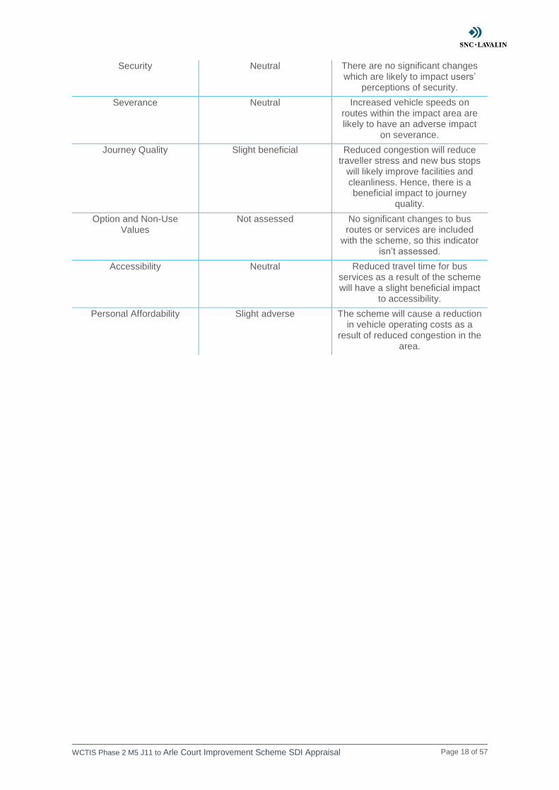
Security Neutral There are no significant changes which are likely to impact users’
perceptions of security.
Severance Neutral Increased vehicle speeds on routes within the impact area are likely to have an adverse impact
on severance.
Journey Quality Slight beneficial Reduced congestion will reduce traveller stress and new bus stops
will likely improve facilities and cleanliness. Hence, there is a beneficial impact to journey
quality.
Option and Non-Use Values
Not assessed No significant changes to bus routes or services are included
with the scheme, so this indicator isn’t assessed.
Accessibility Neutral Reduced travel time for bus services as a result of the scheme will have a slight beneficial impact
to accessibility.
Personal Affordability Slight adverse The scheme will cause a reduction in vehicle operating costs as a
result of reduced congestion in the area.

WCTIS Phase 2 M5 J11 to Arle Court Improvement Scheme SDI Appraisal Page 19 of 57
3. Distributional Impact Appraisal
3.1. Population Data Sources Analysis of the scheme impact area was undertaken using labour market statistics from Nomis. The majority of this data was collected during the 2011 census. Two levels of geography were used in appraisal. Output Areas (OAs) have been used for the population belonging to vulnerable groups considered that reside in each area. This includes children, elderly, women and black and minority ethnic (BAME) residents. The exception to this is income group and Disability Living Allowance (DLA) claimants, which data is only available at Lower Super Output Area (LSOA) level. DLA claimant data is only available for 2001 LSOA geographical areas. Hence, the data used was the most recently collected DLA claimant data (November 2018) at 2001 LSOA level. The source for each population statistic is shown in Table 3-1.
When identifying social groups, percentages have been calculated using the total populations of affected OAs or LSOAs. For the national average this is all OAs / LSOAs within England and OAs / LSOAs within the impact area for each indicator. The proportion of no car households differs, as percentages are calculated based on total households within the geographic area rather than total population.
Table 3-1 Data sources for socio-demographic mapping and population statistics
Statistic Source
Household Income English Indices of Deprivation – Income domain
Age 2011 Census KS102EW – Age Structure
Ethnicity 2011 Census QS201EW – Ethnic Group
DLA claimants Department for Work and Pensions, Work and Pensions Longitudinal Study – Benefit
claimants, Disability Living Allowance for small areas
Car Ownership 2011 Census – KS404EW – Car or van availability
Gender 2011 Census KS101EW – Usual resident population
3.2. Screening Outcome Step one of the DI process involved the completion of a screening proforma, based upon qualitative assessment of the likely impacts of the scheme on each of the eight DI indicators.
The outcome of this screening process identified that all eight indicators should be appraised in detail to determine the affect the measure will have on different social groups of the population, as shown in Table 3-2. The detailed appraisals of each indicator are included in the next section.
Table 3-2 Summary of the screening proforma
Indicator Likely DI Impact Recommendation
User benefits Yes Proceed to Step 2
Noise Yes Proceed to Step 2
Air quality Yes Proceed to Step 2
Accidents Yes Proceed to Step 2
Security No No Further Assessment
Severance Yes Proceed to Step 2
Accessibility No No Further Assessment
Affordability Yes Proceed to Step 2
WCTIS Phase 2 M5 J11 to Arle Court Improvement Scheme SDI Appraisal Page 20 of 57
3.3. Socio-demographic Overview Please see figures Figure 4-1 to Figure 4-7 which give an overview of where there are high proportions of vulnerable groups in the area surrounding the scheme. These show that a high proportion of LSOAs surrounding the scheme location belong to income quintiles 4 and 5 (least income deprived). There are some LSOAs belonging to income quintile 1 (most income deprived) in Gloucester and to the north of Cheltenham. Furthermore, there are OAs with the 20% highest proportion of elderly, and women surrounding the location of the scheme. There are high proportions of children, DLA claimants and no car households around Cheltenham and Gloucester. There is an area in the centre of Gloucester with the 20% highest proportion of BAME residents in England, although there are few high proportions of this surrounding the scheme.
WCTIS Phase 2 M5 J11 to Arle Court Improvement Scheme SDI Appraisal Page 21 of 57
3.4. Accessibility
3.4.1. Screening
Comments
The scheme does not introduce any new bus stops and does not include any relocation of existing bus stops within the immediate area. Bus services that do service the roads involved in the improvement scheme are likely to reach their destination slightly faster, but this is not deemed as a significant impact. Also, it is not yet known if there will be any changes to the timings of public transport facilities. The impact of the scheme to accessibility will not need to be examined further.
Outcome
No further assessment required
WCTIS Phase 2 M5 J11 to Arle Court Improvement Scheme SDI Appraisal Page 22 of 57
3.5. Severance
3.5.1. Screening
Comments
The scheme does not propose any changes to road crossing provision or the introduction of any new public transport. However, the addition of the extra lane and hence additional capacity may cause significant changes to vehicle flow and speed. The impact of the scheme to severance will need to be assessed further.
Outcome
Continue to full DI appraisal
3.5.2. Assessment
3.5.2.1. Step 2a: Confirmation of Impacted Area
The impact area for this severance assessment is a 1km buffer of the scheme and links with greater than 10% change in traffic speed.
3.5.2.2. Step 2b: Identification of Social Groups in Impact Area
Table 3-3 Proportion of population in each vulnerable group for England and the severance study
area
Group England Severance Study Area
Older people (aged 70+) 7.7% 8.2%
Children (aged under 16) 18.9% 18.9%
No car households 25.8% 22.6%
DLA claimants 2.9% 2.5%
3.5.2.3. Step 2c: Identification of Amenities in Impact Area
Nuffield Hospital, Whittington House Nursing Home and St Marks School are in the vicinity of the proposed scheme. There are several more amenities including retail stores, schools and care homes, to the east of the scheme, in Cheltenham which may be accessed by vulnerable groups.
3.5.3. Appraisal
Speed increases and decreases of 10% or more have been used as proxy for severance. Higher speeds make crossing roads more difficult and hence, increase severance. Lower speeds reduce severance by making roads easier to cross.
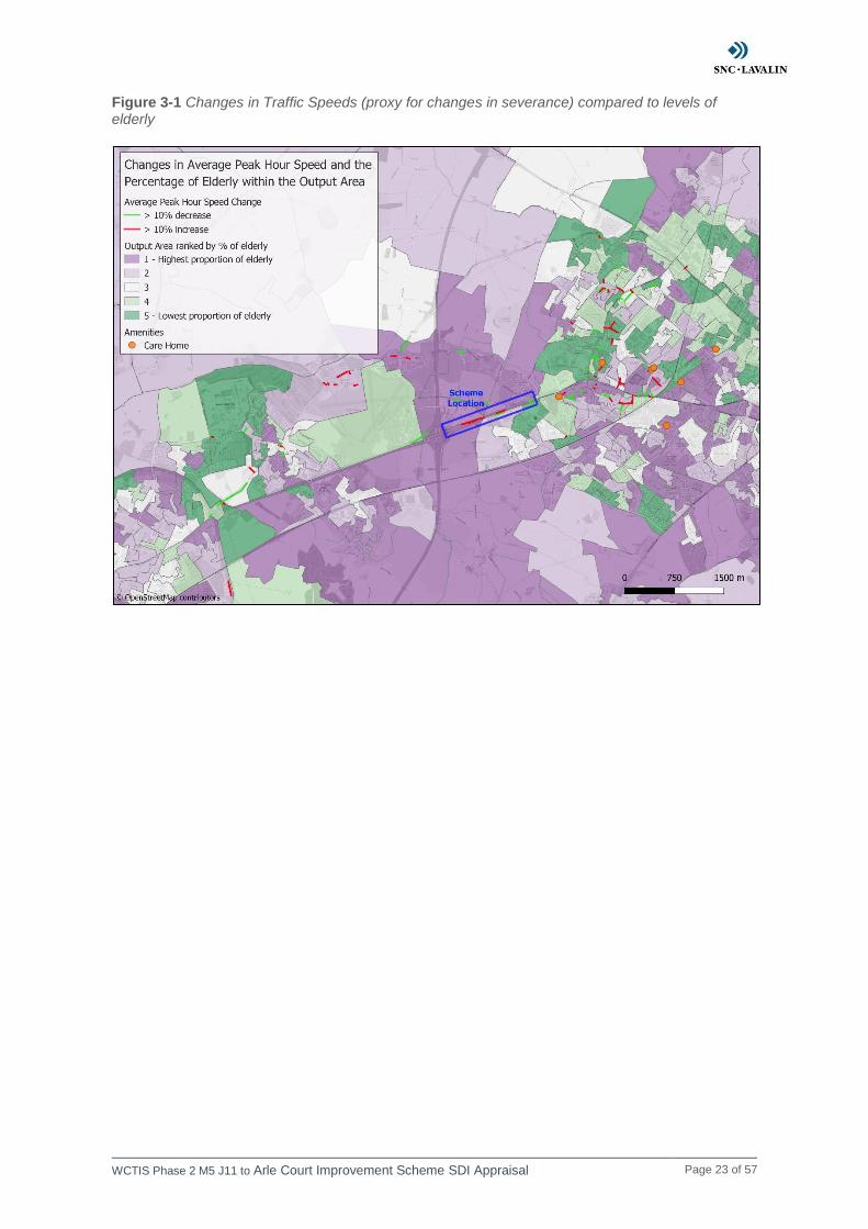
Figure 3-1 shows the proportion of elderly compared to where changes in speeds of greater than 10% occur. In general, elderly people are likely to find crossing the road more difficult. Hence, they are likely to be more vulnerable to changes in severance. The main increases in speed occur on the A40 which cannot be accessed by pedestrians and are crossed by grade separated footways in most cases. Consequently, increased speeds on these roads will not increase severance.
The scheme also increases traffic speeds on some roads radiating from the scheme location. These roads can be accessed by pedestrians and are located predominantly in areas that have higher levels of elderly people.
There are some changes in speed levels within Cheltenham. There are a similar number of increases and decreases in speeds levels within Cheltenham’s western suburbs. The low levels of elderly residents in this area mean that speeds changes will have little effect on the elderly’s ability to cross the road. There are some changes in speed along Cheltenham Road, where there are high proportions of elderly. However, again there are approximately the same number of increases as decreases, so are unlikely to have a significant impact on severance overall in the area.
WCTIS Phase 2 M5 J11 to Arle Court Improvement Scheme SDI Appraisal Page 23 of 57
Figure 3-1 Changes in Traffic Speeds (proxy for changes in severance) compared to levels of elderly
WCTIS Phase 2 M5 J11 to Arle Court Improvement Scheme SDI Appraisal Page 24 of 57
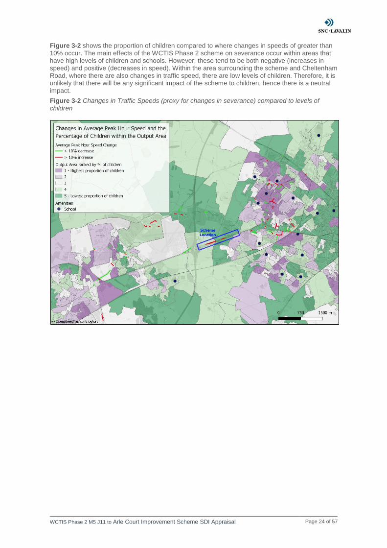
Figure 3-2 shows the proportion of children compared to where changes in speeds of greater than 10% occur. The main effects of the WCTIS Phase 2 scheme on severance occur within areas that have high levels of children and schools. However, these tend to be both negative (increases in speed) and positive (decreases in speed). Within the area surrounding the scheme and Cheltenham Road, where there are also changes in traffic speed, there are low levels of children. Therefore, it is unlikely that there will be any significant impact of the scheme to children, hence there is a neutral impact.
Figure 3-2 Changes in Traffic Speeds (proxy for changes in severance) compared to levels of children

WCTIS Phase 2 M5 J11 to Arle Court Improvement Scheme SDI Appraisal Page 25 of 57
Figure 3-3 shows the proportion of no car households compared to where changes in speeds of greater than 10% occur. Areas with high levels of households without cars are limited to the western suburbs of Cheltenham. The number of increases and decreases within this area are approximately balanced and therefore the effect on severance is likely to be neutral overall.
Figure 3-3 Changes in Traffic Speeds (proxy for changes in severance) compared to levels of households without a car
WCTIS Phase 2 M5 J11 to Arle Court Improvement Scheme SDI Appraisal Page 26 of 57
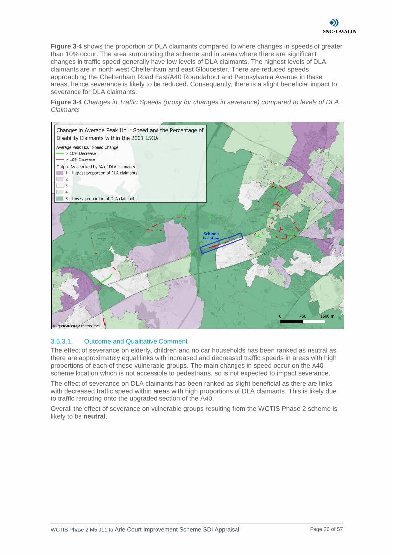
Figure 3-4 shows the proportion of DLA claimants compared to where changes in speeds of greater than 10% occur. The area surrounding the scheme and in areas where there are significant changes in traffic speed generally have low levels of DLA claimants. The highest levels of DLA claimants are in north west Cheltenham and east Gloucester. There are reduced speeds approaching the Cheltenham Road East/A40 Roundabout and Pennsylvania Avenue in these areas, hence severance is likely to be reduced. Consequently, there is a slight beneficial impact to severance for DLA claimants.
Figure 3-4 Changes in Traffic Speeds (proxy for changes in severance) compared to levels of DLA Claimants
3.5.3.1. Outcome and Qualitative Comment
The effect of severance on elderly, children and no car households has been ranked as neutral as there are approximately equal links with increased and decreased traffic speeds in areas with high proportions of each of these vulnerable groups. The main changes in speed occur on the A40 scheme location which is not accessible to pedestrians, so is not expected to impact severance.
The effect of severance on DLA claimants has been ranked as slight beneficial as there are links with decreased traffic speed within areas with high proportions of DLA claimants. This is likely due to traffic rerouting onto the upgraded section of the A40.
Overall the effect of severance on vulnerable groups resulting from the WCTIS Phase 2 scheme is likely to be neutral.

WCTIS Phase 2 M5 J11 to Arle Court Improvement Scheme SDI Appraisal Page 27 of 57
Table 3-4 Severance assessment of scheme by vulnerable group
Vulnerable Group Assessment
Older people (aged 70+) 0
Children (aged under 16) 0
No car households 0
DLA claimants
Overall 0
WCTIS Phase 2 M5 J11 to Arle Court Improvement Scheme SDI Appraisal Page 28 of 57
3.6. Security
3.6.1. Screening
Comments
There are no planned changes to public transport waiting/interchange services. There should be no changes in user perception of personal security since no pedestrianised areas are affected by the scheme.
Outcome
No further assessment required
WCTIS Phase 2 M5 J11 to Arle Court Improvement Scheme SDI Appraisal Page 29 of 57
3.7. Accidents
3.7.1. Screening
Comments
The A40 eastbound merge upgrade to a lane gain with a ghost island merge may have an impact upon the number of accidents in the area.
Increased vehicle capacity and speed as a result of lane gains, changes to merge provision and reduced congestion could impact on the severity of casualties. Therefore, the impacts of the scheme on the accidents in the area needs further assessment.
Outcome
Continue to full DI appraisal
3.7.2. Assessment
3.7.2.1. Step 2a: Confirmation of Impacted Area
According to WebTAG any change in alignment of a transport corridor (or road layout) that may have positive or negative safety impacts should be considered in the safety assessment.
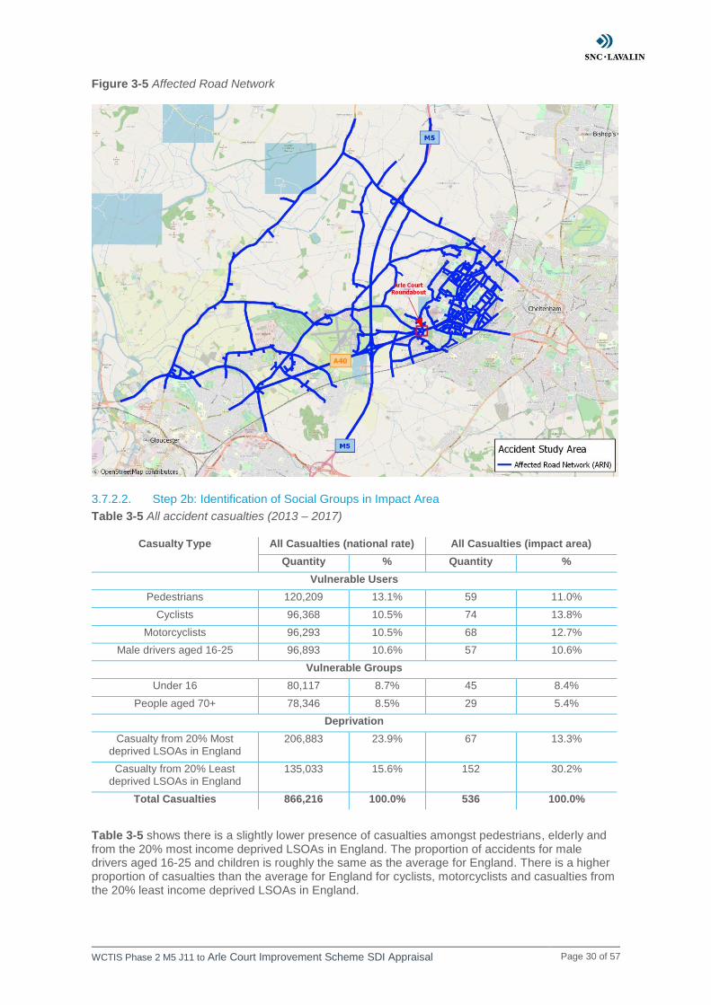
This assessment is qualitative and based on the peak hour change in traffic speed. The accident impact area comprises links and casualties that lie within the road network that will be affected by the scheme, as shown in Figure 3-5. Links within the Affected Road Network (ARN) that are forecast to experience +/-10% change in traffic speed as a result of the scheme and casualties which occur on these links are used to determine the impact to accidents as a result of the scheme.
Percentages are calculated using the total number of casualties (536) that occurred between 2013 and 2017 on all links within the impact area. The casualties have been linked to the LSOAs they reside within, allowing us to calculate the number of casualties across the most and least deprived areas. As this statistic is not always recorded / known, only casualties with known income quintile data were used to calculate percentages. Consequently, the percentages are calculated using lower totals (e.g. for the impact area 503 casualties had income quintile data recorded compared to 536 overall casualties).
WCTIS Phase 2 M5 J11 to Arle Court Improvement Scheme SDI Appraisal Page 30 of 57
Figure 3-5 Affected Road Network
3.7.2.2. Step 2b: Identification of Social Groups in Impact Area
Table 3-5 All accident casualties (2013 – 2017)
Casualty Type All Casualties (national rate) All Casualties (impact area)
Quantity % Quantity %
Vulnerable Users
Pedestrians 120,209 13.1% 59 11.0%
Cyclists 96,368 10.5% 74 13.8%
Motorcyclists 96,293 10.5% 68 12.7%
Male drivers aged 16-25 96,893 10.6% 57 10.6%
Vulnerable Groups
Under 16 80,117 8.7% 45 8.4%
People aged 70+ 78,346 8.5% 29 5.4%
Deprivation
Casualty from 20% Most deprived LSOAs in England
206,883 23.9% 67 13.3%
Casualty from 20% Least deprived LSOAs in England
135,033 15.6% 152 30.2%
Total Casualties 866,216 100.0% 536 100.0%
Table 3-5 shows there is a slightly lower presence of casualties amongst pedestrians, elderly and from the 20% most income deprived LSOAs in England. The proportion of accidents for male drivers aged 16-25 and children is roughly the same as the average for England. There is a higher proportion of casualties than the average for England for cyclists, motorcyclists and casualties from the 20% least income deprived LSOAs in England.

WCTIS Phase 2 M5 J11 to Arle Court Improvement Scheme SDI Appraisal Page 31 of 57
3.7.2.3. Step 2c: Identification of Amenities in Impact Area
Nuffield Hospital is by the proposed scheme location. Cheltenham has many amenities which may be accessed by vulnerable users, including schools, care homes, hospitals and retail stores.
3.7.3. Appraisal
The number of accidents which occurred on links which are expected to have greater than 10% change in traffic speed are shown in Table 3-6. In this instance, any link with greater than 10% decrease in traffic speed is assumed to have a reduction in accident rate. Any link with greater than 10% increase in traffic speed is assumed to have an increase in accident rate. The percentages are calculated based on the total number of casualties on all links within the impact area (including increase, decrease and no change / negligible links).
Table 3-6 Profile of existing casualties by forecast benefit in accidents (2013 to 2017)
Casualty Type Links with >10% increase in traffic speed (Disbenefit)
Links with >10% decrease in traffic speed (Benefit)
N % N %
Vulnerable User
Pedestrians 4 0.7% 0 0.0%
Cyclists 1 0.2% 1 0.2%
Motorcyclists 5 0.9% 1 0.2%
Male drivers aged 16-24 3 0.6% 1 0.2%
Vulnerable Groups
People aged under 16 1 0.2% 0 0.0%
People aged 70+ 2 0.4% 0 0.0%
Deprivation
20% Most deprived LSOAs in UK 5 1.0% 5 1.0%
20% Least deprived LSOAs in UK 3 0.6% 0 0.0%
Total casualties 22 4.1% 12 2.2%
There are only 12 casualties which occurred on links which have greater than 10% increase in traffic speed and 22 on links which are expected to have greater than 10% decrease in traffic speed, as shown in Table 3-6.
Figure 1-3 shows a map of the links which are expected to have an increase or decrease in traffic speeds of 10% or greater as a result of the scheme.
3.7.3.1. Outcome and Qualitative Comment
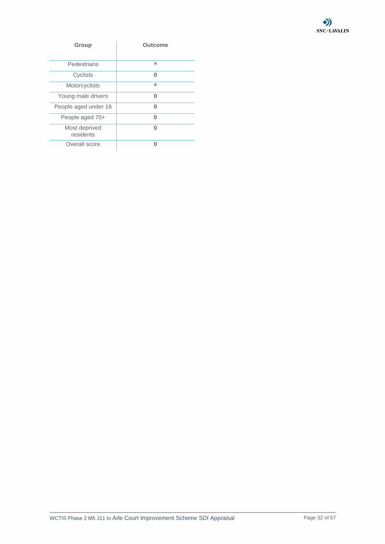
This accident assessment is based on the difference in casualties which occur on links with an increase and decrease in traffic speed. The difference between the number of casualties which occurred on increased and decreased links is approximately the same for cyclists, young male drivers, children, elderly and from the 20% most income deprived LSOAs. Therefore, there is a neutral impact to accidents for these vulnerable users.
There are a greater number of casualties involving pedestrians, motorcyclists and those from the 20% least income deprived LSOAs which occurred on links with an increase in traffic speed than on links with a decrease in traffic speed. Therefore, the scheme may result in an increase in accident rate for these vulnerable users. Since the proportion of accidents occurring on links with greater than 10% change in traffic speed is small for all of these groups, there will be a slight adverse impact to accidents for pedestrians, motorcyclists and those from the 20% least income deprived LSOAs.
Therefore, the overall impact of the scheme to accidents is neutral.
Table 3-7 Accident assessment of scheme by vulnerable users
WCTIS Phase 2 M5 J11 to Arle Court Improvement Scheme SDI Appraisal Page 32 of 57
Group Outcome
Pedestrians
Cyclists 0
Motorcyclists
Young male drivers 0
People aged under 16 0
People aged 70+ 0
Most deprived
residents 0
Overall score 0
WCTIS Phase 2 M5 J11 to Arle Court Improvement Scheme SDI Appraisal Page 33 of 57
3.8. Air Quality
3.8.1. Screening
Comments
There is likely to be increased vehicle speeds and flows caused by an increase in capacity along the A40 eastbound carriageway to Arle Court Roundabout.
Reduced congestion and changes in vehicle speed and flow rates will have an impact on emissions in the area, so air quality impacts need further assessment.
Outcome
Continue to full DI appraisal
3.8.2. Assessment
3.8.2.1. Step 2a: Confirmation of Impacted Area
The DI guidance (TAG Unit A4.2) outlines that air quality impacts are likely to occur where an intervention results in changes to traffic flows or speeds, or where the physical gap between people and traffic is altered.
WebTAG Unit A4.2.3 defines the air quality impact area as a 200m buffer of the scheme and/or where there are any indirect impacts on the transport network. In this instance, the air quality impact area covers links with a change in peak hour traffic speed of greater than 20kph.
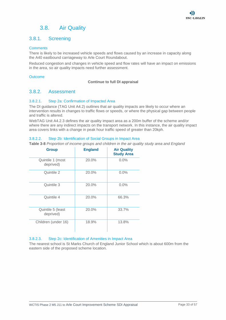
3.8.2.2. Step 2b: Identification of Social Groups in Impact Area
Table 3-8 Proportion of income groups and children in the air quality study area and England
Group England Air Quality Study Area
Quintile 1 (most deprived)
20.0% 0.0%
Quintile 2 20.0% 0.0%
Quintile 3 20.0% 0.0%
Quintile 4 20.0% 66.3%
Quintile 5 (least deprived)
20.0% 33.7%
Children (under 16) 18.9% 13.8%
3.8.2.3. Step 2c: Identification of Amenities in Impact Area
The nearest school is St Marks Church of England Junior School which is about 600m from the eastern side of the proposed scheme location.
WCTIS Phase 2 M5 J11 to Arle Court Improvement Scheme SDI Appraisal Page 34 of 57
3.8.3. Appraisal
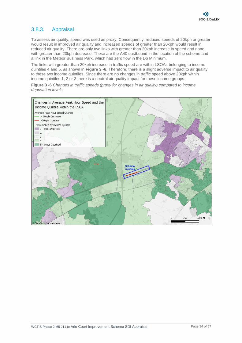
To assess air quality, speed was used as proxy. Consequently, reduced speeds of 20kph or greater would result in improved air quality and increased speeds of greater than 20kph would result in reduced air quality. There are only two links with greater than 20kph increase in speed and none with greater than 20kph decrease. These are the A40 eastbound in the location of the scheme and a link in the Meteor Business Park, which had zero flow in the Do Minimum.
The links with greater than 20kph increase in traffic speed are within LSOAs belonging to income quintiles 4 and 5, as shown in Figure 3 -6. Therefore, there is a slight adverse impact to air quality to these two income quintiles. Since there are no changes in traffic speed above 20kph within income quintiles 1, 2 or 3 there is a neutral air quality impact for these income groups.
Figure 3 -6 Changes in traffic speeds (proxy for changes in air quality) compared to income deprivation levels

WCTIS Phase 2 M5 J11 to Arle Court Improvement Scheme SDI Appraisal Page 35 of 57
Figure 3-7 shows where perceivable air quality effects are likely to occur in relation to the percentage of children in the area. Children are more likely to be affected by air quality changes due to being closer to ground level and being at stage were their bodies are still developing. Consequently, worse air quality in areas with high levels of children is likely to cause issues.
There are low proportions of children where there are links with greater than 20kph increase in traffic speed and no schools in these areas. Therefore, there is a neutral air quality impact to children caused by the scheme.
Figure 3-7 Changes in traffic speeds (proxy for changes in air quality) compared to levels of children
3.8.3.1. Outcome and Qualitative Comment
The main negative effects occur within LSOAs that are less deprived (income quintile 4 and 5). Consequently, income quintiles 4 and 5 experiences a slight adverse impact on air quality with all other areas experiencing no effect.
Due to the air quality effects generally occurring in more rural areas with low numbers of children, air quality effects of the WCTIS Phase 2 scheme on children has been ranked as neutral.
Overall, the WCTIS Phase 2 scheme is likely to have a neutral effect on air quality.
Table 3-9 Air quality assessment of scheme by vulnerable group
Vulnerable Group Assessment
Quintile 1 (most deprived)
0
Quintile 2 0
Quintile 3 0
Quintile 4

WCTIS Phase 2 M5 J11 to Arle Court Improvement Scheme SDI Appraisal Page 36 of 57
Quintile 5 (least deprived)
Children (under 16) 0
Overall 0

WCTIS Phase 2 M5 J11 to Arle Court Improvement Scheme SDI Appraisal Page 37 of 57
3.9. Noise
3.9.1. Screening
Comments
Increased capacity through the extra lane gain on the A40 eastbound carriageway will likely lead to an increase in vehicle flow and speed and reduced congestion, which will likely impact noise levels in the area. Therefore, noise quality impacts will need to be assessed
Outcome
Continue to Full DI Appraisal
3.9.2. Assessment
3.9.2.1. Step 2a: Confirmation of Impacted Area
The WebTAG guidance on DI assessment (Unit A4.2) outlines that noise impacts are likely to occur where an intervention results in changes to traffic flows or speeds, or where the physical gap between people and traffic is altered. The noise impact area is defined as a 600m buffer of an intervention likely to impact on noise. In this instance, the noise impact area covers OAs/LSOAs within 600m of the proposed scheme.
3.9.2.2. Step 2b: Identification of Social Groups in Impact Area
Table 3-10 Proportion of income groups and children in the noise study area and England
Income Group England Noise
Study Area
Quintile 1 (most
deprived)
20.0% 0.0%
Quintile 2 20.0% 0.0%
Quintile 3 20.0% 0.0%
Quintile 4 20.0% 52.8%
Quintile 5 (least
deprived)
20.0% 47.2%
Children (under 16)
18.9% 16.7%
3.9.2.3. Step 2c: Identification of Amenities in Impact Area
The nearest school is St Marks Church of England Junior School which is about 600m from the eastern side of the proposed scheme location.
WCTIS Phase 2 M5 J11 to Arle Court Improvement Scheme SDI Appraisal Page 38 of 57
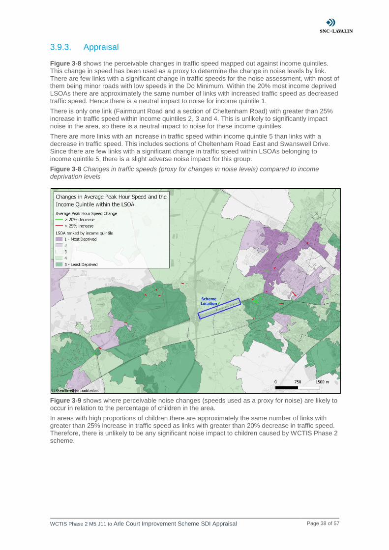
3.9.3. Appraisal
Figure 3-8 shows the perceivable changes in traffic speed mapped out against income quintiles. This change in speed has been used as a proxy to determine the change in noise levels by link. There are few links with a significant change in traffic speeds for the noise assessment, with most of them being minor roads with low speeds in the Do Minimum. Within the 20% most income deprived LSOAs there are approximately the same number of links with increased traffic speed as decreased traffic speed. Hence there is a neutral impact to noise for income quintile 1.
There is only one link (Fairmount Road and a section of Cheltenham Road) with greater than 25% increase in traffic speed within income quintiles 2, 3 and 4. This is unlikely to significantly impact noise in the area, so there is a neutral impact to noise for these income quintiles.
There are more links with an increase in traffic speed within income quintile 5 than links with a decrease in traffic speed. This includes sections of Cheltenham Road East and Swanswell Drive. Since there are few links with a significant change in traffic speed within LSOAs belonging to income quintile 5, there is a slight adverse noise impact for this group.
Figure 3-8 Changes in traffic speeds (proxy for changes in noise levels) compared to income deprivation levels
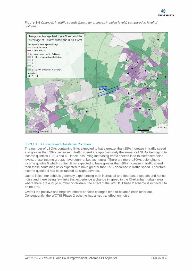
Figure 3-9 shows where perceivable noise changes (speeds used as a proxy for noise) are likely to occur in relation to the percentage of children in the area.
In areas with high proportions of children there are approximately the same number of links with greater than 25% increase in traffic speed as links with greater than 20% decrease in traffic speed. Therefore, there is unlikely to be any significant noise impact to children caused by WCTIS Phase 2 scheme.
WCTIS Phase 2 M5 J11 to Arle Court Improvement Scheme SDI Appraisal Page 39 of 57
Figure 3-9 Changes in traffic speeds (proxy for changes in noise levels) compared to level of children
3.9.3.1.1. Outcome and Qualitative Comment
The number of LSOAs containing links expected to have greater than 25% increase in traffic speed and greater than 20% decrease in traffic speed are approximately the same for LSOAs belonging to income quintiles 1, 2, 3 and 4. Hence, assuming increasing traffic speeds lead to increased noise levels, these income groups have been ranked as neutral. There are more LSOAs belonging to income quintile 5 which contain links expected to have greater than 20% increase in traffic speed than those containing links expected to have greater than 25% decrease in traffic speed. Therefore, income quintile 4 has been ranked as slight adverse.
Due to links near schools generally experiencing both increased and decreased speeds and hence, noise and there being few links that experience a change in speed in the Cheltenham urban area where there are a large number of children, the effect of the WCTIS Phase 2 scheme is expected to be neutral.
Overall the positive and negative effects of noise changes tend to balance each other out. Consequently, the WCTIS Phase 2 scheme has a neutral effect on noise.
WCTIS Phase 2 M5 J11 to Arle Court Improvement Scheme SDI Appraisal Page 40 of 57
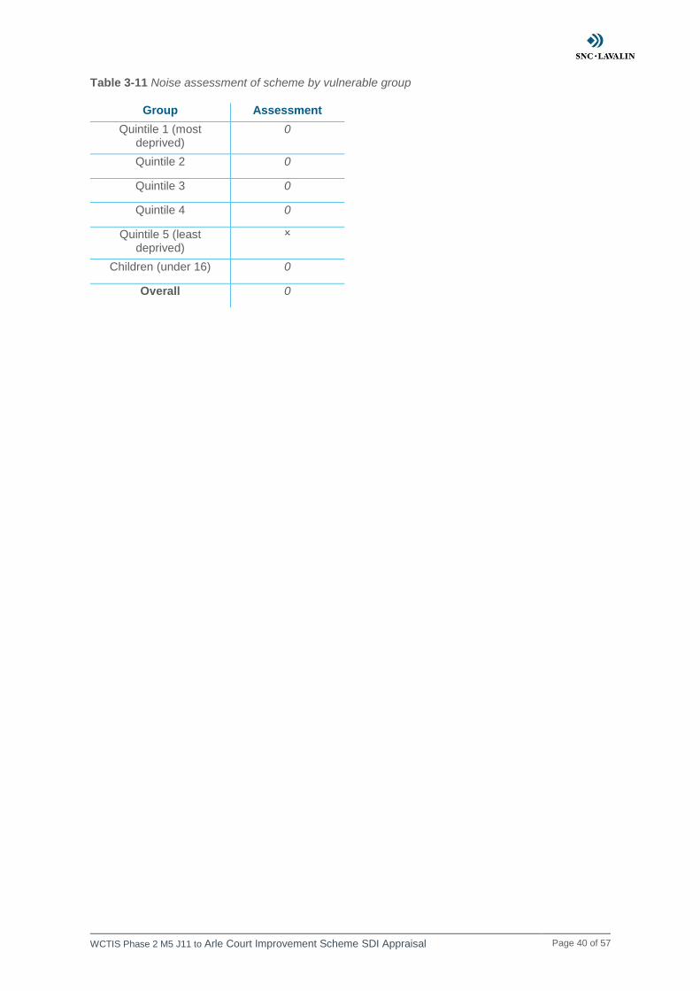
Table 3-11 Noise assessment of scheme by vulnerable group
Group Assessment
Quintile 1 (most deprived)
0
Quintile 2 0
Quintile 3 0
Quintile 4 0
Quintile 5 (least deprived)
Children (under 16) 0
Overall 0
WCTIS Phase 2 M5 J11 to Arle Court Improvement Scheme SDI Appraisal Page 41 of 57
3.10. User Benefits
3.10.1. Screening
Comments
Additional lanes on the roundabout circulatory, the A40 approaches and exits and the widening of the southern arm will increase the junction capacity. This will likely lead to increased traffic flow and speed and hence reduced journey times. Therefore, the impact to user benefits will need to be assessed.
Outcomes
Continue to full DI appraisal
3.10.2. Assessment
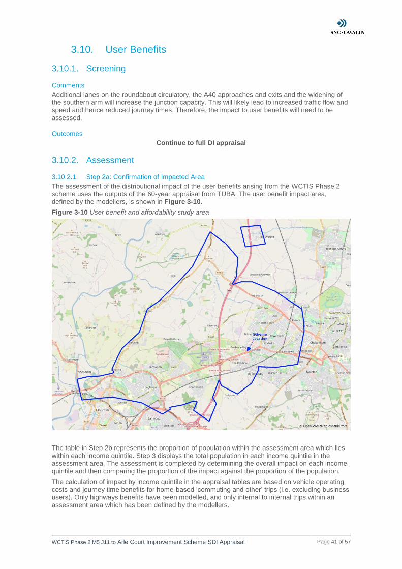
3.10.2.1. Step 2a: Confirmation of Impacted Area
The assessment of the distributional impact of the user benefits arising from the WCTIS Phase 2 scheme uses the outputs of the 60-year appraisal from TUBA. The user benefit impact area, defined by the modellers, is shown in Figure 3-10.
Figure 3-10 User benefit and affordability study area
The table in Step 2b represents the proportion of population within the assessment area which lies within each income quintile. Step 3 displays the total population in each income quintile in the assessment area. The assessment is completed by determining the overall impact on each income quintile and then comparing the proportion of the impact against the proportion of the population.
The calculation of impact by income quintile in the appraisal tables are based on vehicle operating costs and journey time benefits for home-based ‘commuting and other’ trips (i.e. excluding business users). Only highways benefits have been modelled, and only internal to internal trips within an assessment area which has been defined by the modellers.

WCTIS Phase 2 M5 J11 to Arle Court Improvement Scheme SDI Appraisal Page 42 of 57
3.10.2.2. Step 2b: Identification of Social Groups in Impact Area
Table 3-12 Proportion of income groups in the user benefit study area and England
Income Group
England Study Area
Quintile 1 (most
deprived)
20.0% 15.3%
Quintile 2 20.0% 19.7%
Quintile 3 20.0% 14.5%
Quintile 4 20.0% 20.3%
Quintile 5 (least
deprived)
20.0% 30.3%
3.10.2.3. Step 2c: Identification of Amenities in Impact Area
Identification of amenities is not required according to WebTAG guidance for user benefits.

WCTIS Phase 2 M5 J11 to Arle Court Improvement Scheme SDI Appraisal Page 43 of 57
3.10.3. Appraisal The percentage of the population in each income quintile is calculated based on the postcodes that are within the assessed impact area. Table 3-13 represents the proportion of the population in each income quintile in the assessment area. The calculations include the overall impact, a sum of the total benefits and disbenefits, this is then further segregated into the total benefits and disbenefits for each income quintile. Furthermore, the percentage proportion of benefits and disbenefits across each of the income quintiles is calculated in order to determine the overall assessment score for each quintile.
Table 3-13 Distribution of user benefits by income quintiles in the study area
Income Quintile
Total Quintile 1 Quintile 2 Quintile 3 Quintile 4 Quintile 5
Total population in
the assessment
area
12,239 15,696 11,540 16,164 24,175 79,814
Proportion of total
population in each quintile in
the assessment
area
15.3% 19.7% 14.5% 20.3% 30.3% -
Sum of benefits £968,049 £1,255,972 £949,129 £1,753,549 £2,285,982 £7,212,680
Proportion of benefits for
each income quintile 13.4% 17.4% 13.2% 24.3% 31.7% -
Sum of disbenefits £- £- £- -£137,551 -£232,106 -£369,657
Proportion of disbenefits for each income
quintile 0.0% 0.0% 0.0% 37.2% 62.8% -
Overall net change £968,049 £1,255,972 £949,129 £1,615,998 £2,053,876 £6,843,023
Assessment Moderate Beneficial
Moderate Beneficial
Moderate Beneficial
Moderate Beneficial
Moderate Beneficial
Moderate Beneficial
Key: ✓✓✓ Large Beneficial ✓✓ Moderate Beneficial ✓ Slight beneficial 0 Neutral
Slight adverse Moderate adverse Large adverse
Key to individual assessment of each Income quintile
Beneficial and 5% greater (or more) than the proportion of the group in the total population
Large Beneficial
Beneficial and in line (+/-5%) with the proportion of the group in the total population Moderate Beneficial
Beneficial and 5% smaller (or less) than the proportion of the group in the total population
Slight Beneficial
There are no user benefits or disbenefits experienced by the group Neutral
A disbenefit which is 5% smaller (or less) than the proportion of the group in the total population
Slight Adverse
A disbenefit which is in line (+/-5%) with the proportion of the group in the total population
Moderate Adverse

WCTIS Phase 2 M5 J11 to Arle Court Improvement Scheme SDI Appraisal Page 44 of 57
A disbenefit which is 5% greater (or more) than the proportion of the group in the total population
Large Adverse
There are beneficial impacts to user benefits for all income quintiles. This is likely caused by
reduced congestion along the A40 eastbound as a result of increased capacity along the route. This
will lead to a reduction in travel times and vehicle operating costs as there’s reduced vehicles idling
and braking and accelerating while queueing.
3.10.3.1. Outcome and Qualitative Comment
There are beneficial impacts for all income quintiles as a result of the WCTIS Phase 2 scheme. The distribution of benefits is within 5% of the proportion of the population in each income group. Therefore, the user benefits are evenly distributed for the WCTIS Phase 2 scheme and there is a moderate beneficial impact for each income group and overall.
Table 3-14 User benefit assessment of scheme by vulnerable group
Vulnerable Group
Outcome
Quintile 1 (most
deprived)
Quintile 2
Quintile 3
Quintile 4
Quintile 5 (least
deprived)
Overall
WCTIS Phase 2 M5 J11 to Arle Court Improvement Scheme SDI Appraisal Page 45 of 57
3.11. Affordability
3.11.1. Screening
Comments
Increased capacity through the Arle Court Roundabout due to additional lanes on the circulatory and A40 and the widening of the southern arm will likely increase vehicle flow and speed. This will have a cost impact and hence the affordability impact of the scheme will need to be examined.
Outcome
Continue to full DI appraisal
3.11.2. Assessment
3.11.2.1. Step 2a: Confirmation of Impacted Area
The assessment of the distributional impact of the user benefits arising from the WCTIS Phase 2 scheme uses the outputs of the 60-year appraisal from TUBA. The affordability study area is the same as the user benefit study area, shown in Figure 3-10.
The table in Step 2b represents the proportion of population within the assessment area which lies within each income quintile. Step 3 displays the total population in each income quintile in the assessment area. The assessment is completed by determining the overall impact on each income quintile and then comparing the proportion of the impact against the proportion of the population.
The calculation of impact by income quintile in the appraisal tables are based on vehicle operating costs and journey time benefits for home-based ‘commuting and other’ trips (i.e. excluding business users). Only highways benefits have been modelled, and only internal to internal trips within an assessment area which has been defined by the modellers.
3.11.2.2. Step 2b: Identification of Social Groups in Impact Area
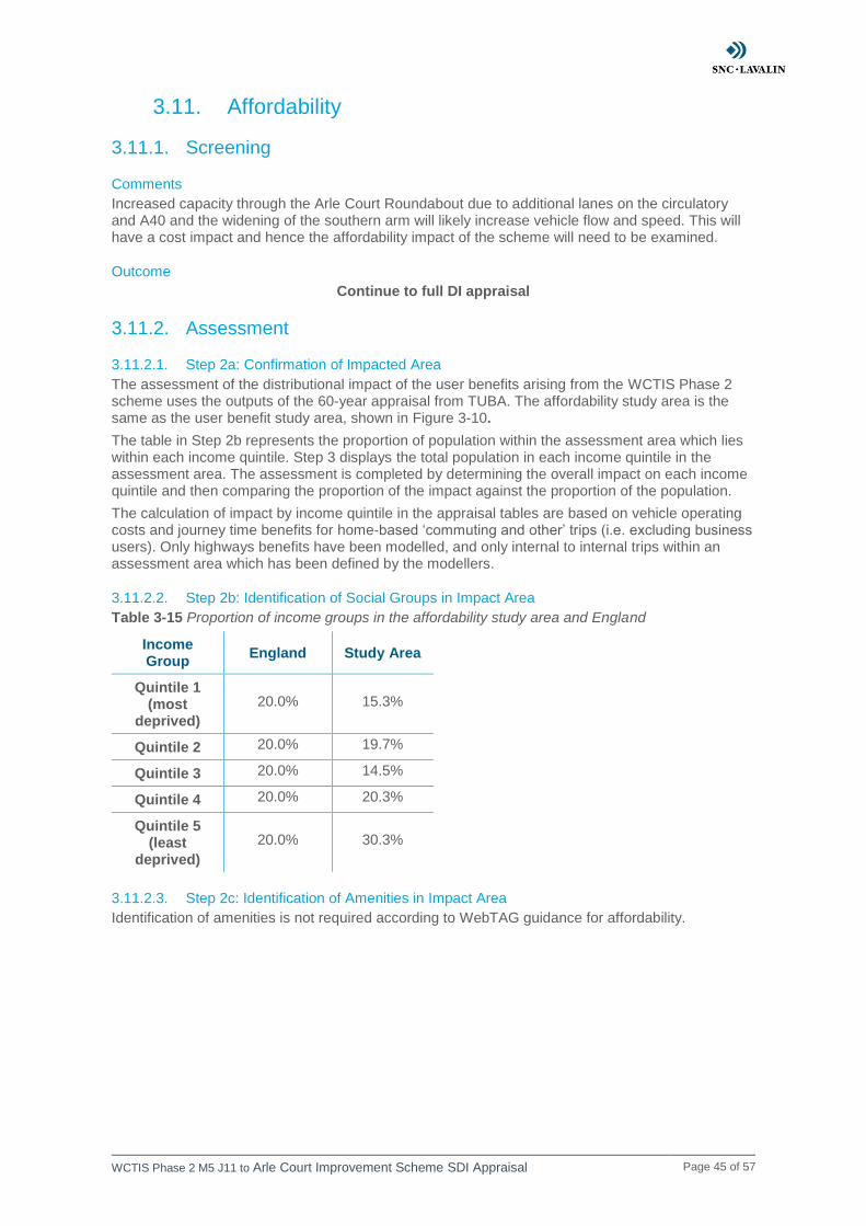
Table 3-15 Proportion of income groups in the affordability study area and England
Income Group
England Study Area
Quintile 1 (most
deprived)
20.0% 15.3%
Quintile 2 20.0% 19.7%
Quintile 3 20.0% 14.5%
Quintile 4 20.0% 20.3%
Quintile 5 (least
deprived)
20.0% 30.3%
3.11.2.3. Step 2c: Identification of Amenities in Impact Area
Identification of amenities is not required according to WebTAG guidance for affordability.
WCTIS Phase 2 M5 J11 to Arle Court Improvement Scheme SDI Appraisal Page 46 of 57
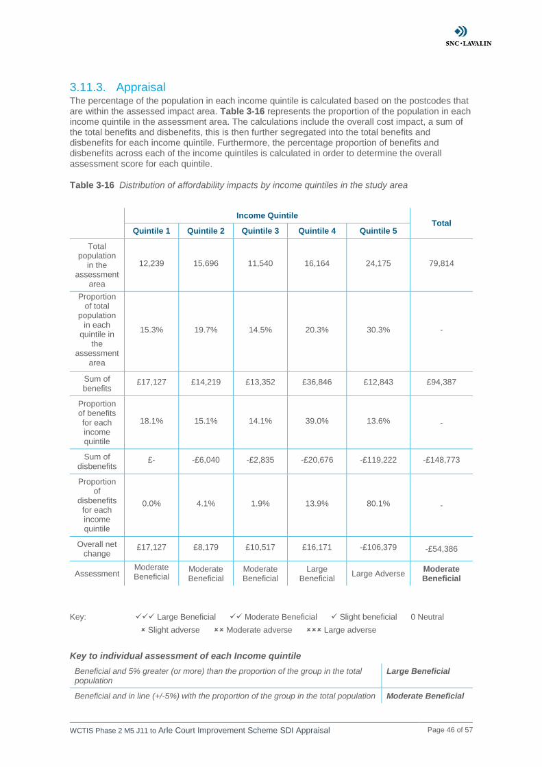
3.11.3. Appraisal The percentage of the population in each income quintile is calculated based on the postcodes that are within the assessed impact area. Table 3-16 represents the proportion of the population in each income quintile in the assessment area. The calculations include the overall cost impact, a sum of the total benefits and disbenefits, this is then further segregated into the total benefits and disbenefits for each income quintile. Furthermore, the percentage proportion of benefits and disbenefits across each of the income quintiles is calculated in order to determine the overall assessment score for each quintile.
Table 3-16 Distribution of affordability impacts by income quintiles in the study area
Income Quintile
Total Quintile 1 Quintile 2 Quintile 3 Quintile 4 Quintile 5
Total population
in the assessment
area
12,239 15,696 11,540 16,164 24,175 79,814
Proportion of total
population in each
quintile in the
assessment
area
15.3% 19.7% 14.5% 20.3% 30.3% -
Sum of benefits
£17,127 £14,219 £13,352 £36,846 £12,843 £94,387
Proportion of benefits for each income quintile
18.1% 15.1% 14.1% 39.0% 13.6% -
Sum of disbenefits
£- -£6,040 -£2,835 -£20,676 -£119,222 -£148,773
Proportion of
disbenefits for each income quintile
0.0% 4.1% 1.9% 13.9% 80.1% -
Overall net change
£17,127 £8,179 £10,517 £16,171 -£106,379 -£54,386
Assessment Moderate Beneficial
Moderate Beneficial
Moderate Beneficial
Large Beneficial
Large Adverse Moderate Beneficial
Key: ✓✓✓ Large Beneficial ✓✓ Moderate Beneficial ✓ Slight beneficial 0 Neutral
Slight adverse Moderate adverse Large adverse
Key to individual assessment of each Income quintile
Beneficial and 5% greater (or more) than the proportion of the group in the total population
Large Beneficial
Beneficial and in line (+/-5%) with the proportion of the group in the total population Moderate Beneficial
WCTIS Phase 2 M5 J11 to Arle Court Improvement Scheme SDI Appraisal Page 47 of 57
Beneficial and 5% smaller (or less) than the proportion of the group in the total population
Slight Beneficial
There are no user benefits or disbenefits experienced by the group Neutral
A disbenefit which is 5% smaller (or less) than the proportion of the group in the total population
Slight Adverse
A disbenefit which is in line (+/-5%) with the proportion of the group in the total population
Moderate Adverse
A disbenefit which is 5% greater (or more) than the proportion of the group in the total population
Large Adverse
There is an adverse impact to affordability to income quintile 5 and beneficial affordability impacts
for all other income quintiles. Increased capacity along the A40 will reduce congestion along the
corridor. This is likely to reduce vehicle operating costs as there’s reduced vehicles idling, braking
and accelerating while queueing. The adverse affordability impacts are likely caused by increased
vehicle speeds leading to increased fuel consumption and hence increased vehicle operating costs.
This is likely the cause of the affordability disbenefit for income quintile 5, as shown in Table 3-16.
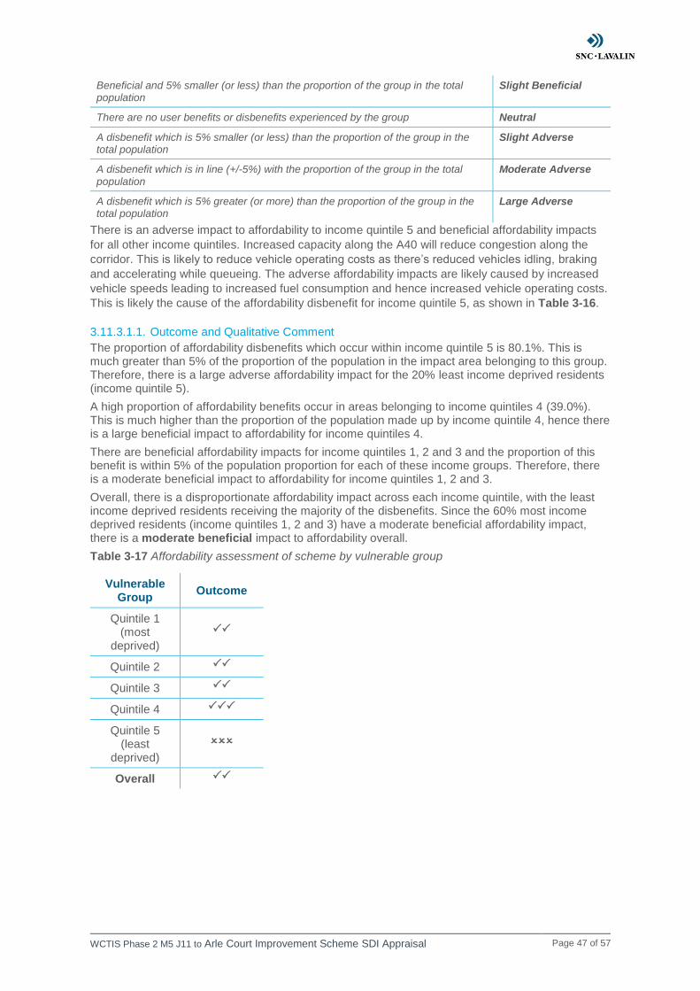
3.11.3.1.1. Outcome and Qualitative Comment
The proportion of affordability disbenefits which occur within income quintile 5 is 80.1%. This is much greater than 5% of the proportion of the population in the impact area belonging to this group. Therefore, there is a large adverse affordability impact for the 20% least income deprived residents (income quintile 5).
A high proportion of affordability benefits occur in areas belonging to income quintiles 4 (39.0%). This is much higher than the proportion of the population made up by income quintile 4, hence there is a large beneficial impact to affordability for income quintiles 4.
There are beneficial affordability impacts for income quintiles 1, 2 and 3 and the proportion of this benefit is within 5% of the population proportion for each of these income groups. Therefore, there is a moderate beneficial impact to affordability for income quintiles 1, 2 and 3.
Overall, there is a disproportionate affordability impact across each income quintile, with the least income deprived residents receiving the majority of the disbenefits. Since the 60% most income deprived residents (income quintiles 1, 2 and 3) have a moderate beneficial affordability impact, there is a moderate beneficial impact to affordability overall.
Table 3-17 Affordability assessment of scheme by vulnerable group
Vulnerable Group
Outcome
Quintile 1 (most
deprived)
Quintile 2
Quintile 3
Quintile 4
Quintile 5 (least
deprived)
Overall
WCTIS Phase 2 M5 J11 to Arle Court Improvement Scheme SDI Appraisal Page 48 of 57
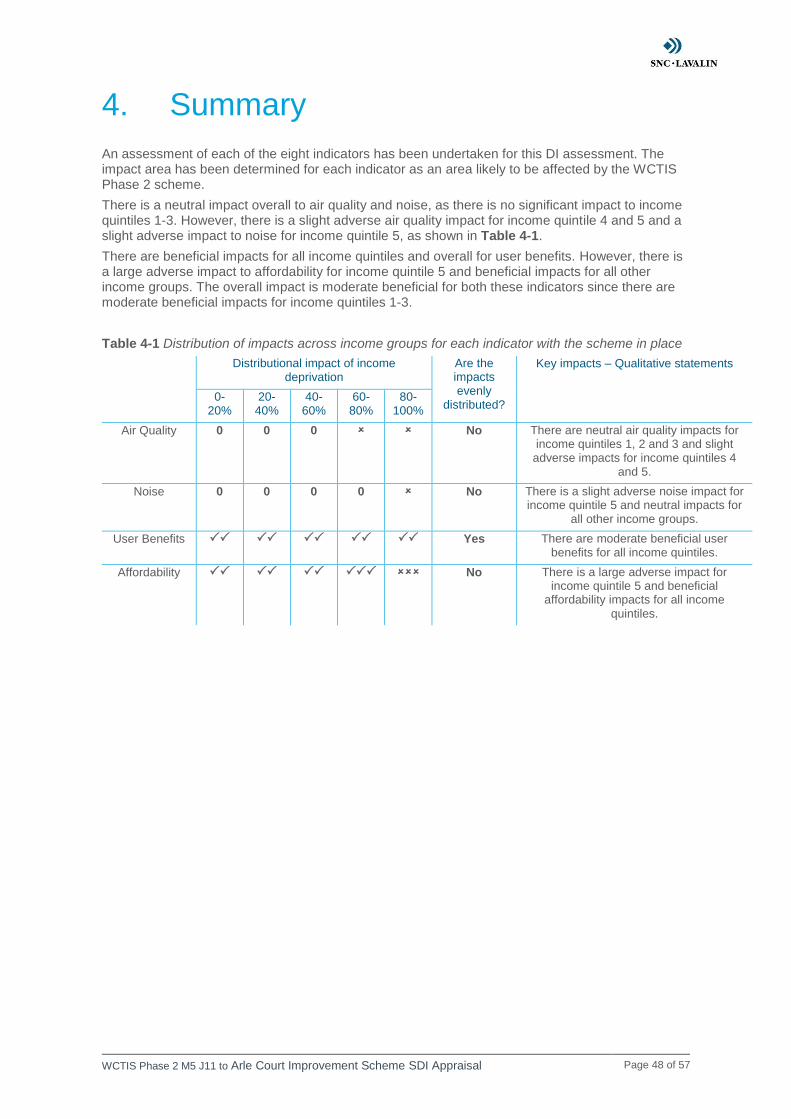
4. Summary
An assessment of each of the eight indicators has been undertaken for this DI assessment. The impact area has been determined for each indicator as an area likely to be affected by the WCTIS Phase 2 scheme.
There is a neutral impact overall to air quality and noise, as there is no significant impact to income quintiles 1-3. However, there is a slight adverse air quality impact for income quintile 4 and 5 and a slight adverse impact to noise for income quintile 5, as shown in Table 4-1.
There are beneficial impacts for all income quintiles and overall for user benefits. However, there is a large adverse impact to affordability for income quintile 5 and beneficial impacts for all other income groups. The overall impact is moderate beneficial for both these indicators since there are moderate beneficial impacts for income quintiles 1-3.
Table 4-1 Distribution of impacts across income groups for each indicator with the scheme in place
Distributional impact of income deprivation
Are the impacts evenly
distributed?
Key impacts – Qualitative statements
0-20%
20-40%
40-60%
60-80%
80-100%
Air Quality 0 0 0 No There are neutral air quality impacts for income quintiles 1, 2 and 3 and slight
adverse impacts for income quintiles 4 and 5.
Noise 0 0 0 0 No There is a slight adverse noise impact for income quintile 5 and neutral impacts for
all other income groups.
User Benefits Yes There are moderate beneficial user benefits for all income quintiles.
Affordability No There is a large adverse impact for income quintile 5 and beneficial
affordability impacts for all income
quintiles.
WCTIS Phase 2 M5 J11 to Arle Court Improvement Scheme SDI Appraisal Page 49 of 57
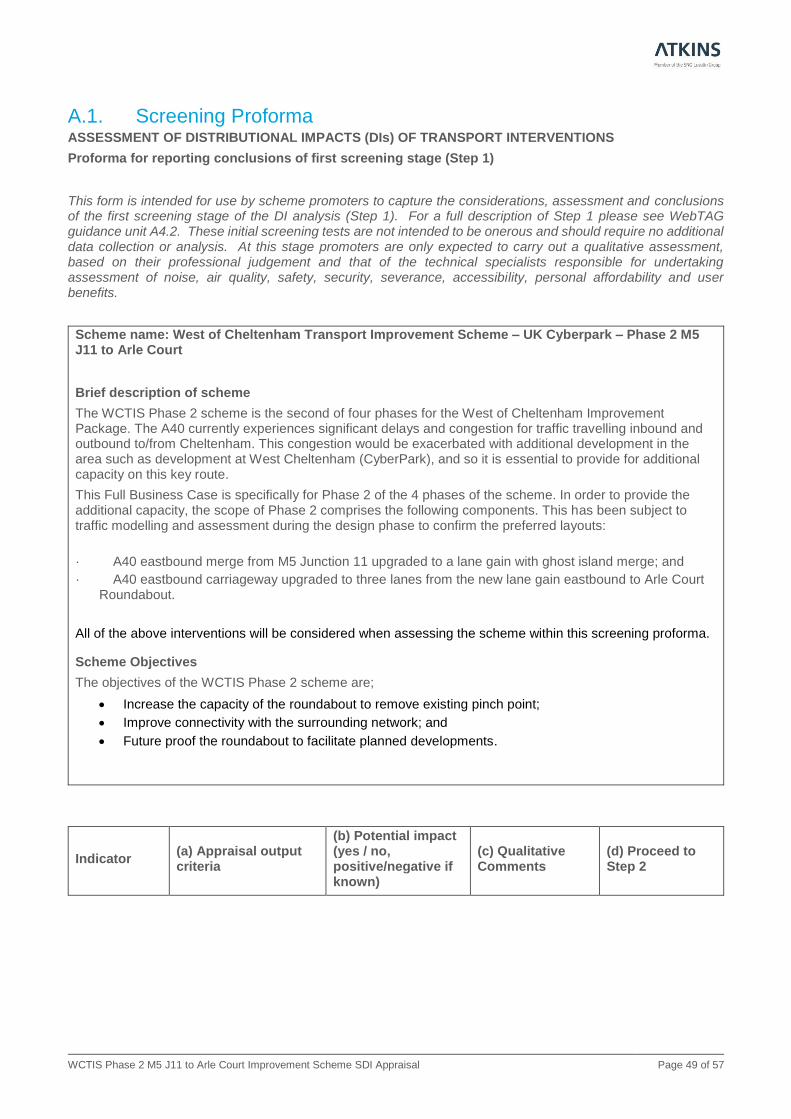
A.1. Screening Proforma ASSESSMENT OF DISTRIBUTIONAL IMPACTS (DIs) OF TRANSPORT INTERVENTIONS
Proforma for reporting conclusions of first screening stage (Step 1)
This form is intended for use by scheme promoters to capture the considerations, assessment and conclusions of the first screening stage of the DI analysis (Step 1). For a full description of Step 1 please see WebTAG guidance unit A4.2. These initial screening tests are not intended to be onerous and should require no additional data collection or analysis. At this stage promoters are only expected to carry out a qualitative assessment, based on their professional judgement and that of the technical specialists responsible for undertaking assessment of noise, air quality, safety, security, severance, accessibility, personal affordability and user benefits.
Scheme name: West of Cheltenham Transport Improvement Scheme – UK Cyberpark – Phase 2 M5 J11 to Arle Court
Brief description of scheme
The WCTIS Phase 2 scheme is the second of four phases for the West of Cheltenham Improvement Package. The A40 currently experiences significant delays and congestion for traffic travelling inbound and outbound to/from Cheltenham. This congestion would be exacerbated with additional development in the area such as development at West Cheltenham (CyberPark), and so it is essential to provide for additional capacity on this key route.
This Full Business Case is specifically for Phase 2 of the 4 phases of the scheme. In order to provide the additional capacity, the scope of Phase 2 comprises the following components. This has been subject to traffic modelling and assessment during the design phase to confirm the preferred layouts:
· A40 eastbound merge from M5 Junction 11 upgraded to a lane gain with ghost island merge; and
· A40 eastbound carriageway upgraded to three lanes from the new lane gain eastbound to Arle Court Roundabout.
All of the above interventions will be considered when assessing the scheme within this screening proforma.
Scheme Objectives
The objectives of the WCTIS Phase 2 scheme are;
• Increase the capacity of the roundabout to remove existing pinch point;
• Improve connectivity with the surrounding network; and
• Future proof the roundabout to facilitate planned developments.
Indicator (a) Appraisal output criteria
(b) Potential impact (yes / no, positive/negative if known)
(c) Qualitative Comments
(d) Proceed to Step 2
WCTIS Phase 2 M5 J11 to Arle Court Improvement Scheme SDI Appraisal Page 50 of 57
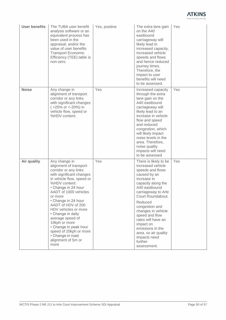
User benefits The TUBA user benefit analysis software or an equivalent process has been used in the appraisal; and/or the value of user benefits Transport Economic Efficiency (TEE) table is non-zero.
Yes, positive The extra lane gain on the A40 eastbound carriageway will likely lead to increased capacity, increased vehicle speeds and flows and hence reduced journey times. Therefore, the impact to user benefits will need to be assessed.
Yes
Noise Any change in alignment of transport corridor or any links with significant changes ( >25% or <-20%) in vehicle flow, speed or %HDV content.
Yes Increased capacity through the extra lane gain on the A40 eastbound carriageway will likely lead to an increase in vehicle flow and speed and reduced congestion, which will likely impact noise levels in the area. Therefore, noise quality impacts will need to be assessed
Yes
Air quality Any change in alignment of transport corridor or any links with significant changes in vehicle flow, speed or %HDV content: • Change in 24 hour AADT of 1000 vehicles or more • Change in 24 hour AADT of HDV of 200 HDV vehicles or more • Change in daily average speed of 10kph or more • Change in peak hour speed of 20kph or more • Change in road alignment of 5m or more
Yes There is likely to be increased vehicle speeds and flows caused by an increase in capacity along the A40 eastbound carriageway to Arle Court Roundabout.
Reduced congestion and changes in vehicle speed and flow rates will have an impact on emissions in the area, so air quality impacts need further assessment.
Yes
WCTIS Phase 2 M5 J11 to Arle Court Improvement Scheme SDI Appraisal Page 51 of 57
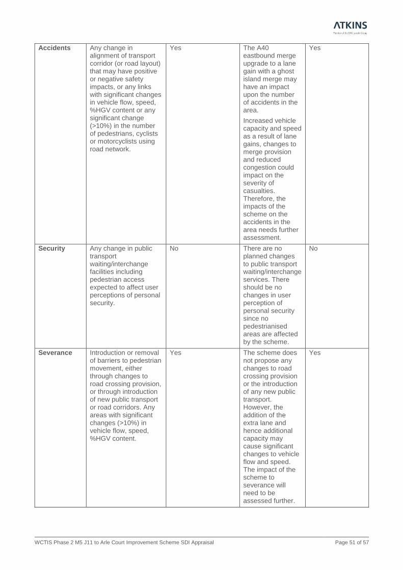
Accidents Any change in alignment of transport corridor (or road layout) that may have positive or negative safety impacts, or any links with significant changes in vehicle flow, speed, %HGV content or any significant change (>10%) in the number of pedestrians, cyclists or motorcyclists using road network.
Yes The A40 eastbound merge upgrade to a lane gain with a ghost island merge may have an impact upon the number of accidents in the area.
Increased vehicle capacity and speed as a result of lane gains, changes to merge provision and reduced congestion could impact on the severity of casualties. Therefore, the impacts of the scheme on the accidents in the area needs further assessment.
Yes
Security Any change in public transport waiting/interchange facilities including pedestrian access expected to affect user perceptions of personal security.
No There are no planned changes to public transport waiting/interchange services. There should be no changes in user perception of personal security since no pedestrianised areas are affected by the scheme.
No
Severance Introduction or removal of barriers to pedestrian movement, either through changes to road crossing provision, or through introduction of new public transport or road corridors. Any areas with significant changes (>10%) in vehicle flow, speed, %HGV content.
Yes The scheme does not propose any changes to road crossing provision or the introduction of any new public transport. However, the addition of the extra lane and hence additional capacity may cause significant changes to vehicle flow and speed. The impact of the scheme to severance will need to be assessed further.
Yes
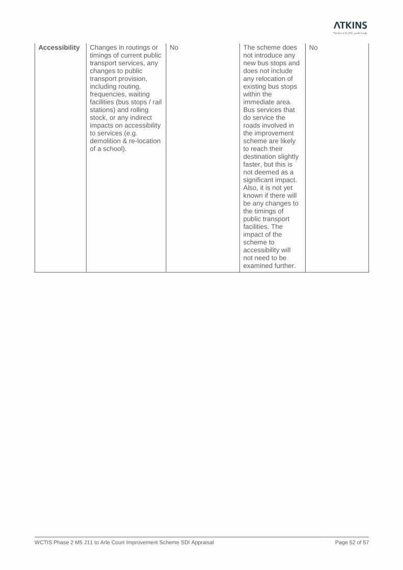
WCTIS Phase 2 M5 J11 to Arle Court Improvement Scheme SDI Appraisal Page 52 of 57
Accessibility Changes in routings or timings of current public transport services, any changes to public transport provision, including routing, frequencies, waiting facilities (bus stops / rail stations) and rolling stock, or any indirect impacts on accessibility to services (e.g. demolition & re-location of a school).
No The scheme does not introduce any new bus stops and does not include any relocation of existing bus stops within the immediate area. Bus services that do service the roads involved in the improvement scheme are likely to reach their destination slightly faster, but this is not deemed as a significant impact. Also, it is not yet known if there will be any changes to the timings of public transport facilities. The impact of the scheme to accessibility will not need to be examined further.
No

WCTIS Phase 2 M5 J11 to Arle Court Improvement Scheme SDI Appraisal Page 53 of 57
Affordability In cases where the following charges would occur; Parking charges (including where changes in the allocation of free or reduced fee spaces may occur); Car fuel and non-fuel operating costs (where, for example, rerouting or changes in journey speeds and congestion occur resulting in changes in costs); Road user charges (including discounts and exemptions for different groups of travellers); Public transport fare changes (where, for example premium fares are set on new or existing modes or where multi-modal discounted travel tickets become available due to new ticketing technologies); or Public transport concession availability (where, for example concession arrangements vary as a result of a move in service provision from bus to light rail or heavy rail, where such concession entitlement is not maintained by the local authority[1]).
Yes The eastbound carriageway upgrade to three lanes from the new lane gain up to Arle Court Roundabout will likely reduce congestion and result in an increase in vehicle speed and flow. This will have a cost impact and hence the affordability impact of the scheme will need to be examined.
Yes
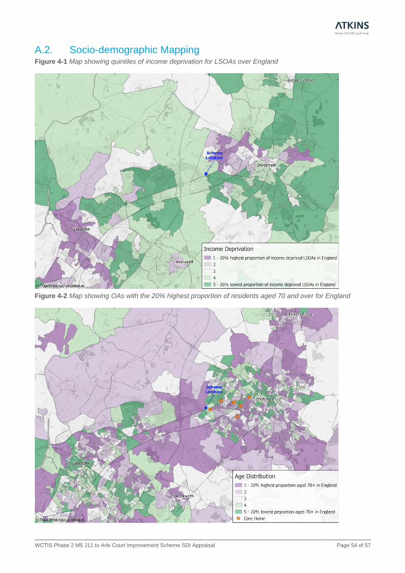
WCTIS Phase 2 M5 J11 to Arle Court Improvement Scheme SDI Appraisal Page 54 of 57
A.2. Socio-demographic Mapping Figure 4-1 Map showing quintiles of income deprivation for LSOAs over England
Figure 4-2 Map showing OAs with the 20% highest proportion of residents aged 70 and over for England

WCTIS Phase 2 M5 J11 to Arle Court Improvement Scheme SDI Appraisal Page 55 of 57
Figure 4-3 Map showing OAs with the 20% highest proportion of BME residents for England
Figure 4-4 Map showing OAs with the 20% highest proportion of DLA claimants for England
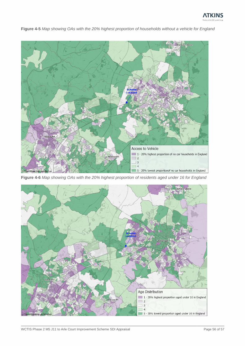
WCTIS Phase 2 M5 J11 to Arle Court Improvement Scheme SDI Appraisal Page 56 of 57
Figure 4-5 Map showing OAs with the 20% highest proportion of households without a vehicle for England
Figure 4-6 Map showing OAs with the 20% highest proportion of residents aged under 16 for England

WCTIS Phase 2 M5 J11 to Arle Court Improvement Scheme SDI Appraisal Page 57 of 57
Figure 4-7 Map showing OAs with the 20% highest proportion of women for England