Embed Size (px)
Citation preview

Abstract—With regard to increasing the population growth
and increasing the volume and variety of urban wastes, sanitary
landfill procedure is one of the most common excretion ways in
different countries. There is several ways for locating the waste
landfill sites. In this research it has been tried to select suitable
site for waste landfill of tourist city of Sarein which is placed in
north-western of Ardabil province in Iran country by using the
GIS software package and integrating the Saw and AHP
methods. For this purpose, in the first step Sarein's urban waste
landfill site was selected based on Iran's Department of
Environment's criteria with applying the GIS software and
AHP method.
After overlaying of mentioned-criteria maps, four sites was
selected that had maximum score by evaluating of properties of
identified sites, one of sites was identified as the first priority by
using the SAW method.
Index Terms—Sanitary landfill, multi-criteria analysis
method, GIS software, Arbabil, Iran.
I. THESE INTRODUCTION
Waste is one of materials that has direct relationship with
population increasing. This dirty gold has various problems at
all of steps including production and landfill.
So that if it is not carefully planned, it will lead to
economical and health problems. In these planning's, one of
the complicated steps is locating of waste landfill sites waste
landfill sites have precise steps including site selecting and
preparation of waste landfill site. Each of these steps requires
engineering studies and sound management [1] in selection of
waste landfill sites in addition to the environmental
considerations that must be addressed, including the distance
from the river, distance from the fault, and distance from the
Road and …, The waste landfill sites must be accepted by the
people.
Because if these landfill sites is near the individual's
workplace or living places, it is considered as a negative
outcome and it may cause irreparable consequences to human
life [2].
Manuscript received November 2, 2015; revised March 22, 2015.
Seiied Taghi Seiied Safavian is with the Young Researchers and Elite
Club, Ardabil Branch, Islamic Azad University, Ardabil, Iran (e-mail:
Ebrahim Fataei is with the Environmental Engineering Department,
Ardabil Branch, Islamic Azad University, Ardebil, Iran (e-mail:
Taghi Ebadi is with the Faculty of Environmental Engineering,
Amirkabir University of Technology, Tehran, Iran (e-mail:
Ali Mohamadian is with Technical College, University Dusseldorf,
Düsseldorf, Germany (e-mail: [email protected]).
Currently, highly accurate tool was used for selecting and
locating the waste landfill one of these tools is using the
satellite data and GIS [2], [3]. Today, many researchers are
using GIS capabilities for locating waste landfill site. Because
geographic information system is able to analyze of vast
volume of information layers [4], [5].
In this context, many studies can be mentioned that have
been able to do waste landfill locating with good precision by
using the GIS technique.
In 2003, wastara and Naswate have been conducted
locating of American's urban landfill sites by using the GIS
and RS with regard to criteria such as geology, fault, slope of
the land and … . Also several researchers including Yeslinear,
Cetrin, Al-Harrah, Qdais Kontos and et al have involved in
locating waste landfill sites by using the GIS techniques
[6]-[8]. Qdais, Kontos have used from multi-criteria analysis
(MCDM) along with applying GIS Techniques for the best
site selecting [8], [9].
In this research, locating and selecting of waste landfill site
was implemented by using the GIS software and AHP method
and also with applying the one of SAW decision methods. In
the applied method problems formulating possibility as
hierarchy has been provided and this possibility is provided in
problems with regarding different qualitative and quantitative
criteria [4]. In this method, work has been based on the even
comparison that was simplified justification and calculations.
Also it shows amount of consistency and consistency in
multi-criteria decision [10], [11]. Therefore in this research,
SAW method has been used for prioritizing of land fill site
selection Tourist city of Sarein in geographical coordination
of 48/040 eastern longitude and 38/090 northern latitude with
up to 1280000 m2 area is placed in 28 Kilometers away from
west of Ardabil city. And north-west of Iran. The city's
average height is 1650 meters from sea level.
This city has 6121 settled population in 2011 in terms of
last census. In addition to urban settled population, due to
being tourist attractive, this city according to the cultural
Heritage and Tourism organization of Ardabil province this
city welcome 5200000 tourists from the country and all over
the world. According to present statistics, maximum daily
tourist number has bee report about 85000 people during the
tourist presence peak in summer in rejoin.
The amount of waste production per capita in this city is
0.930 kilograms a day generally, in this city, something more
than 6453 tones of waste is produced annually.
At present, neither recycling system nor separation from
origin was conducted in this city.
Due to rapid development of tourist facilities and
installations in this region, current landfill site would not
respond to urban wastes landfill in future, there fore, locating
Site Selection of Sarein's Municipal Solid Waste Landfill
Using the GIS Technique and SAW Method
Seiied Taghi Seiied Safavian, Ebrahim Fataei, Taghi Ebadi, and Ali Mohamadian
International Journal of Environmental Science and Development, Vol. 6, No. 12, December 2015
934DOI: 10.7763/IJESD.2015.V6.725

a new site is necessary and this research has been conducted
for considering this issue.
II. MATERIALS AND METHODS
In this study, for selecting suitable sites for locating and
overlaying of layers was conducted by using GIS software and
AHP method. In this step mapping was conducted based on
department of environment's criteria (Table I). After
overlaying of produced maps by AH that has been conducted
with polling from expertise people about weighted ranking of
mentioned criteria in expert choice software environment
(plot 1). Suitable sites were specified for urban waste landfill
in Sareing town's territory.
TABLE I: IRAN'S DEPARTMENT OF ENVIRONMENT CRITERIA FOR SELECTING
LANDFILL
The criteria Mode of action and Conditions
Fault Minimum distance of 200 meters.
Surface water
resources
Minimum horizontal distance of 1000 meters from
the river
Groundwater
Minimum depth of shallow groundwater and a
minimum horizontal distance of 10 meters to 400
meters.
Soil With topsoil as possible of silty clay and sandy silt in
the next phase of the
Residential Minimum distance of 1 km from the rural areas and
Limits the minimum distance of 1 km
Geology A possible bedrock of igneous rocks and is
impermeable.
Roads Minimum distance of 300 meters.
Slope Slope of less than 20%
Land Have valuable uses such as agriculture, forest,
wetland and grassland there.
Airport Privacy International Airport 3 km from eight local
Graph 1: PAIRED comparisons of criteria and factors.
In continue, for selecting of the best choice by using the
SAW model, each criterion's interior matrices were
completed by extracting interior information from each
landfill cite and questionnaire setting.
In multi-criteria decision, problems and specifically
multi-induces decision problems, having and knowing the
relative weight of present indices had been effective step in
problem solving process. From determining methods of
weights of indices, following methods can be mentioned:
1) Applying the elite's response
2) Linmp method
3) Least squares method
4) Special vector technique
5) Shanon's entropy and so on.
In this research, Shanon entropy method has been used as
one of the most popular methods of calculating the indices
weights for achieving indices relative weights entropy in
social sciences, physics and information theory when a design
matrix's data is completely specified Shanon's entropy method
could be used for evaluating the weights.
The idea behind this method is that the more the dispersion
in values of an index the more important that index than the
other indices.
Scoring steps to indices by using the Shanon's Entropy
includes:
1) Data matrix formation: Table II is showing 10 parameters
related to department of environment's criteria that have
been used as index in SAW method for place evaluating
of data. In SAW method, for data matrix formation, each
data's matrix cell has been completed by expert's
comments and GIS and AHP software's output (Table
III).
TABLE II: PARAMETER OF THE 10'S
Index Descriptions
C-1 Slope
C+2 Aspect
C+3 Land
C+4 Tip of land
C+5 Geology
C+6 Fault
C+7 River
C+8 Road
C+9 City
C+10 Rural
TABLE III: PARAMETER OF THE 10'S
Indicators Options C-1 C+
2 C+3 C+
4 C+5 C+
6 C+7 C+
8 C+9 C+
10
A1 8 5 5 7 9 6 9 10 5 5
A2 4 6 3 5 3 3 9 8 5 3
A3 2 4 4 2 4 2 4 6 3 4
A4 1 6 4 2 1 1 3 6 2 4
2) Descaling of decision matrix by using the clock method:
After provision of first matrices, because different indices
may had different scales, used indices must be released
from scale and indices without consistency must be
remover. Descaling is obtained in terms of equation 1:
1
ij
mij
iji
rP
r (1)
Pij = descaled number of indices
rij = scores of indices
3) Index entropy calculation. In the third step, we find
indices entropy by using the equation 2.
PPE ijij
m
ijK ln
1
(2)
K amount obtained by equation 3.
1
Ln( )K
m (3)
International Journal of Environmental Science and Development, Vol. 6, No. 12, December 2015
935
m= number of choices.
4) Calculating the lack of confidence or degree of deviation:
In the fourth step, we calculated deviation degree amount
for any amount by equation 4.
1 jjd E (4)
dj = degree of deviation.
5) Calculating the indices weight: in the final step, we
obtained indices weight by using the equation 5 that these
weights has been presented in Table III.
1
j
nj
jj
dW
d
(5)
Wj = indices weight.
After obtaining the indices weight by using the Shanon
entropy, in the line of research, SAW method has been
applied for ranking landfill sits.
1) Data matrix formation: this research's data matrix was
presents in Table III.
2) Linear de-scaling of decision matrix amounts there
formula has been used for descaling in this model. If we
have positive aspect in matrix, then we apply equation 6.
Max
ij
ij
ij
an
a (6)
aij = indices score.
If we have negative aspect in matrix, we apply equation 7.
1Max
ij
ij
ij
an
a (7)
If we have both negative and positive aspects we apply
equation 8. 1
1
Max
ij
ij
ij
an
a
(8)
3) Multiplying de-scaled matrix by weights of indices.
In this step, we multiplied weight of indices obtained from
Shanon entropy by de scaled matrix and, then add together
and in this way each landfill site's weight was obtained. This
step could be written as equation 9.
total shW W N (9)
III. DISCUSSION AND CONCLUSION
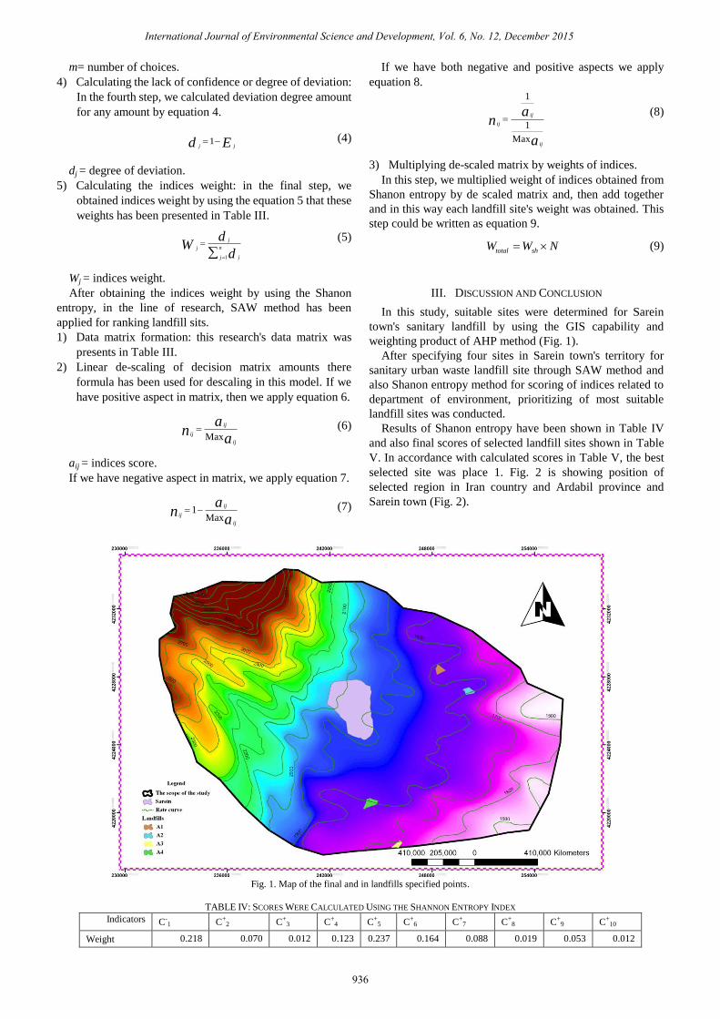
In this study, suitable sites were determined for Sarein
town's sanitary landfill by using the GIS capability and
weighting product of AHP method (Fig. 1).
After specifying four sites in Sarein town's territory for
sanitary urban waste landfill site through SAW method and
also Shanon entropy method for scoring of indices related to
department of environment, prioritizing of most suitable
landfill sites was conducted.
Results of Shanon entropy have been shown in Table IV
and also final scores of selected landfill sites shown in Table
V. In accordance with calculated scores in Table V, the best
selected site was place 1. Fig. 2 is showing position of
selected region in Iran country and Ardabil province and
Sarein town (Fig. 2).
Fig. 1. Map of the final and in landfills specified points.
TABLE IV: SCORES WERE CALCULATED USING THE SHANNON ENTROPY INDEX
Indicators C-1 C+
2 C+3 C+
4 C+5 C+
6 C+7 C+
8 C+9 C+
10
Weight 0.218 0.070 0.012 0.123 0.237 0.164 0.088 0.019 0.053 0.012
International Journal of Environmental Science and Development, Vol. 6, No. 12, December 2015
936

Fig. 2. Location of selected sites and Ardabil in Iran.
TABLE V: SCORES WERE CALCULATED USING THE SAW METHOD FOR
LANDFILLS
Landfills A1 A1 A1 A1
Score 0.985 0.596 0.503 0.428
IV. CONCLUSION
In this study, GIS software's capability and weighting
through AHP method in expert choice software's environment
was used for the locating of Sarein town's sanitary waste
landfill site. SAW method has been used for determining the
best site from specified sites. Results showed that the best site
is the choice of A1 place that is placed in 400 meters distance
from road which has 2 percent general slope. Results obtained
from field studies implies that selected region has maximum
distance from surface and underground waters and its geology
structure generally is impervious metamorphic rocks and the
selected region is kind ofarid lands and low steppe's plant
covering. The field evaluations of present study in light of
specified landfill sites and first determined place priority
through SAW method showed that combinatorial application
of GIS software and AHP and the SAW method could allow
researchers to locate sites with high accuracy.
REFERENCE
[1] H. Neyma, “Locating solid waste materials landfill site by using the
GIS for Tehran City,” Master's Thesis, Technical Faculty, University of
Tarbiyat Modarras, 2000.
[2] M. Masoud, Locating Solid Waste Materials Landfills Sites, Bearie of
Human Environment, Department of Environment, Tehran, 1999, pp.
45-99.
[3] J. R. Eastman, IDRISI for Windows Users Guide, Clark Labs for
Cartographic Technology and Geographic Analysis, Clarc University,
1997.
[4] G. F. Bonham, Carter, GIS for Geoscientists, Modeling with GIS and
Disposal, The General Services Administration’s, USA.
[5] A. Guzman and J. Reyes, “Solid waste management: Mapping out
solutions at the local level,” Local Government Support Program,
Services with Impact: Resources books for Local Government, Manila,
Philippines, pp. 102-125, 2003.
[6] A. J. Omar and A. Q. Hani, “Municipal solid waste landfill siting,
using intelligent system,” Waste Management, vol. 3, pp. 299-306,
2005.
[7] M. S. Kuo and G. S. Liang, “Combining VIKOR with GRA techniques
to evaluate service quality of airports under fuzzy environment,”
Expert Systems with Applications, pp. 1304-1312, 2011.
[8] C. Jones, “Investment analysis and management,” International
Journals of Jhon Willey & Sons, pp. 192-195, 1998.
[9] F. Sortino and N. P. Lee, “Performance measurement in a downside
risk framework,” Investing, pp. 59-64, 1994.
[10] S. Liu and Y. Lin, Grey Information Theory and Practical
Applications, London, Springer, 2006, pp. 55-68.
[11] K. David, Grey System and Grey Relational Model, ACM SIGICE
Bulletin, 2007, pp. 1-9.
Seiied Taghi Seiied Safavian is a graduate student at
Amirkabir University of Technology in the field of
environmental engineering resident.
He is the owner of 7 articles ISI, over 45 conference
papers, more than 8 patents, 1 book (in print), the
academic peer 3 research projects, 20 project partners
outside the university.
He has got the President's Award for Research. He is a student
researcher at University of Technology.
International Journal of Environmental Science and Development, Vol. 6, No. 12, December 2015
937