Embed Size (px)
Citation preview
::::
((
3
(
(
(
3
/
3
3
3
(
/
(
(
3
/(
(( 3
3
(
(
/
(
3
3
(
(
(
(
(( (
3
/
/" /
(
/
((
//
/
(
(((
3(
(
/
//
(
(
(
/ /
(
(
(
((
(
((
(
(
(
(
(
(
/
/
/
/
(
/
(
/
((((
/
/
(((
/
/
(
/
(
/
/
/ /
/
/
/
/
/
/
/
/
3
/
/
3
/
3
((
(
(
(
((
/
/
!(!(
!(!(!(
!(
!(
!(
!(
!(
!( !( !(
!(
!(!(!(
!( !(!(
!(
!(
!(
!(!(
!(!(
!(!(
!(!(
!(
!(!(
!(!(
!(!(
!(
!(!(!(!(
!(!(
!(!(
!(!(
!(
!(!( !(!( !( !( !(!(
!(!( !( !(
!(
!(!(
!(!(
!(!(!(
!(!(
!(!(
!(!(
!(
!(!( !(!(
!(!( !(
!( !(
!(
!(!(
!(!( !(
!(!(!(!(
!(!(
!(!(!(
!(
!(!(
!( !(
!(
!(!(!(
!(!(!( !( !(
!(!( !( !(!(!(
!(!( !( !(!( !(
!( !( !(!(
!( !(
!(!(
!(!(!(!(
!(!(!(!( !(!( !(!(
!( !( !(
!(!( !(!(
!(!(
!( !(
!( !(!(!(!( !(
!(!(
!(
!(
!( !(!(
!(!(!( !( !(!(
!( !(!(
!( !(!(
!( !( !(!(
!( !(!(!(
!(!(
!( !( !(!(!(
!(!(
!( !(
!(!(!( !(!(!(
!( !(!(
!(!(!(
!(
!(
!(!(
!(
!(!(!(!( !( !(!(
!(!(!(!(
!(
!(
!(!(
!(!(
!(
!(!( !(
!(
!(
!( !(!(!(
!(!(!( !(
!(!( !( !(
!(!(!(
!(!(!(
!(!(
!(
!(!(
!( !(!(!(
!( !(
!(!(!( !(
!( !(!(!(
!(!(
!(!( !(
!( !(
!(
!(!(!( !(
!(!(
!(
!(
!(
!(!(
!(!(
!(
!( !(!(
!(!(
!(!( !(
!(!(!(
!( !(
!(
!( !( !(!(
!(!(
!(
!( !(!( !(
!(
!(!(
!( !( !(!(!(!(
!(!(!(
!(!(
!(!( !(
!(!( !(!(
!(
!(!(
!(!(
!(!(
!( !(
769
879
303
839
397
787
597
504
811
483
370
1025
608
536
531
809
416
323
877
581
518
825
603
1390
377
1024
1031
612
1383
826
784
820
760
1382
500
810
806
1027
1028
1056
535
372
590
584
1373
600
429
325
492
522
418
423
804
592
513
369
782
588
869
529
502
767
511
331
873
309
322
609
831
814
757
586
321
1045
433
1030
1020
759
1377
1362
419
766
803
494
1049
1033
1360
1021
424
493
1385
595
379
1384
746
1389
1376411
818
607
314
789
489
871
524
503
421
1361
1367
805
398
541
1378
403
420
505
779765
1055
413
1375
1036
781
827
1047
1038
1050
501
801
409
487
528
417
783
310
327
361
1043
319
1051
1366
829
515
605
367
507
1019
405
878
381
425
870
832
776
753
1379
374
537
526
432
543
813
785
311
360
601
1369
497
836
796
382
606
808
415
1359
520
1053
604
751
540610
376
817
329
366
362
3751364
383
582
490
1042
791
835
307
313
795
756
414
824
758
357
358
1029
775
3591023837
523
400
598
510
748
752
762
755
819
834
772
484
317
402
426485
593
306
777
499
486
812
823
822
368
312
315
799
599
1040
802
318
872
1046
517
363
538
532
747
365
583
304
750
764
516
525
326
330
1386
1032
830
1054
373
602
521
431
774
874
539
519
596
401761
1026
412
427
533
407
542
768
754
821
508
833
396
530
410
793
786
1388
798
324
428430
1370
1034
591
875
1380
491
790
828
800
1037
380
1381
1044
408
404514
587
1387
509
320
794
1372
399
1374
328
792
1391
1371
771
1052
1048
1392
506
422
1022
594
585
876
797
773
512
589
527
1365
788
1057
816
488
1363
1035
305
1368
496
745
770
378
763
815
498
611
778
1039
838
749
371
434
316
495
364
406
780
534
1041
P E N I N S U
CheenisLake
Salmon
Bay
e
CSln
I Asak Kee
N EE
N
NOD
N
L
a
LLEWD
L
P EN I N SU LA
EE
KA
L
Cold
Y w
L el
I l
ME
P
yae
ka
Ly
li
m
A eninsul
BELLInlet
MTBriggs
CH
AN
NE
L
LAK
SP
I L L E R
C
Mosq ui to
Bay
A
SP
I
P E N I N S U L
OV
E
LL
ER
E
G eraldP oint
DO
N
AT
D O N
De Freitas
Islets
PE
NI
NS
UL
A
CarmichaelP oint
U rsusP oint
Cr
ee
k
ekaL
lanoD
Cr
ee
k
I
Y
TE
LN
I
SA
KE
EN
ek
asy
e t
S
E
L
O
A N
B
D
UL
LO
CK
S a l m o n B a
Coldwell
BR
SNINEPIG
GS
LL EOLF N
NBylimE
LE
T
P eninsula
LE
NN
AH
C
LUSNINEP
EWDLOC R
IN
LE
T
LOC
103A.059103A.060
093D.051
103A.049
103A.050093D.041
103A.039 103A.040093D.031
Nanaimo
V ictoria
V ancouver
Campbell R iver
British Columbia
Washington
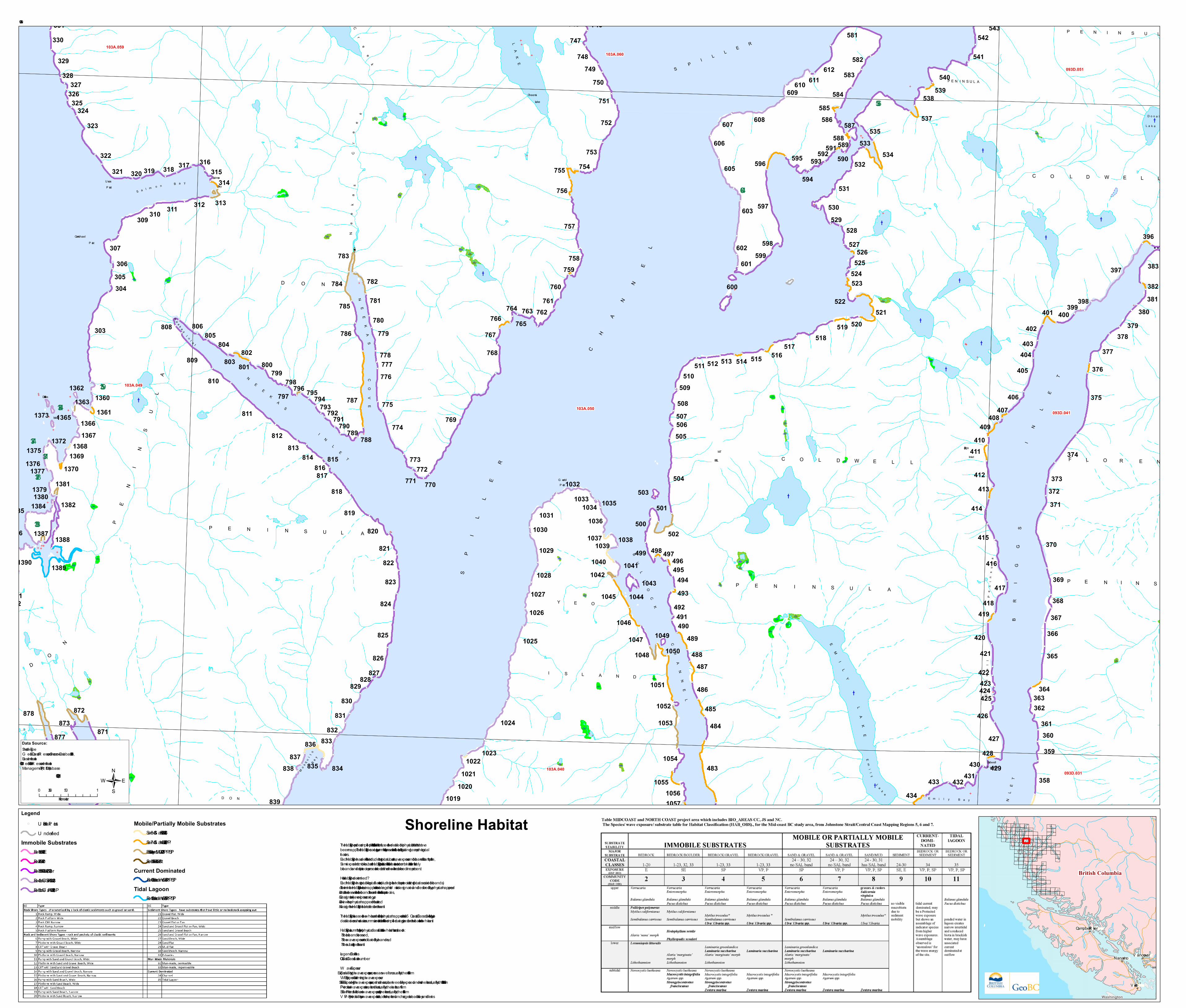
Legend!( U nit Break P oints
U ndefinedImmobile Substrates
1 - Bedrock - CC 1-20 - V E2 - Bedrock - CC 1-20 - E3 - Bedrock/Boulder - CC 1-23, 32, 33 - SE4 - Bedrock/G ravel - CC 1-23, 33 - SP5 - Bedrock/G ravel - CC 1-23,33 - P /V P
Mobile/Partially Mobile Substrates6 - Sand & G ravel - CC 24-26, 32 -SP7 - Sand & G ravel - CC 24-26,32 - V P /P8 - Estuary or Sand/Mud - CC 27-31 - V P /P /SP9 - Sediment - CC 21 - 30 - SE/E
Current Dominated10 - Bedrock or Sediment - CC 34 - V P /P /SP
Tidal Lagoon11 - Bedrock or Sediment - CC 35 - V P /P /SP
Shoreline Habitat
103A.050
The Habitat Type provides a simplified picture of the "look" of the unit overall, based on the detailed biophysical attributes that havebeen mapped. The Habitat Type category is a summary of the observations of both the unit's biologial and geomorphologicalfeatures.Each Habitat Type has a definition that includes the typical substrate, wave exposure and biobands. For example, for theSemi-exposed, Immobile substrate Habitat Type, part of the definition of that class is a certain combination of the most likely biobands and indictor species present at a bedrock shoreline with no mobile sediment present. How is Habitat Type determined?Each Habitat Type has typical biological features (including both an indicator species list and typical associated biobands). To determine the Habitat Type, the biomapper looks at the along-shore U nits as designated and described by the physical mapper, and1.records the observations of the biobands in the unit and looks for indicator species, 2.assigns a bio-(wave) exposure category, 3.reviews the physical mapped information, and 4.assigns the Habitat Type that best describes the unit.The Habitat Type is based on the whole unit and is similar to the physical mappers use of the ‘Coastal Class’ category, in that thedetailed across-shore data are summarized into one attribute. The simplified category describes the features of the whole unit. Habitat Type is a summary of the biophysical classification of the whole shore unit, based on:•the biobands observed, •the wave exposure as indicated by the bands, and •the substrate types in the unit.Legend DefinitionsCC - Coastal Classification numberW ave ExposureE - Exposed - V ery high wave exposure, open ocean swellsm usually fetches >500kmV E - V ery Exposed - Extreme high wave exposureSE - Semi Exposed - High wave exposure, open shorelines, areas between fully exposed and more sheltered, usually fetches 50 to 500kmP - P rotected - Low wave expsoure, sheltered inlets, usually fetches less than 10kmSP - Semi P rotected - Moderate wave expsoure, partly sheltered, usually fetches 10-50kmV P - V ery P rotected - V ery low wave exposure, fethces < 1km, sheltered anchorages at heads of bays and inletes
Data Source:Shoreline TypeG eoBC Coastal R esource Shorezone Database, 2008Base Information1:20,000 G eoBC Terrain R esource Information Management (TR IM) Database
0 0.5 10.25Kilometers
1:20,000
/