Embed Size (px)
Citation preview
CALIFORNIA NATURAL RESOURCES AGENCY | RESOURCES.CA.GOV/ECORESTORE
Reclamation District 341, with funding from the California Department of Water Resources (DWR), constructed four sections of setback levee to increase levee stability along Mayberry Slough on Sherman Island in 2004 and 2005. The Sherman Island setback levee represents an opportunity to reverse some of the ecological damage resulting from levee construction and maintenance, by implementing a habitat development project that will augment the existing riparian vegetation and provide habitat for native species. The project restored tidal wetland and riparian habitat.
The setback levee totals approximately 6,100 linear feet and cost $5.8 million to construct. Increased flood protection and a concomitant net gain of habitat in the Sacramento-San Joaquin Delta are goals of Assembly Bill 360 (AB 360; Delta Levees Program).
Construction of the waterside portion of the setback levee was divided into two phases (Phase IIA, Phase IIB), and the two phases were completed in Fall 2008 and 2009, respectively. Plant monitoring and maintenance was ongoing until 2013.
TIDAL MARSH, SHADED AQUATIC RIVERINE, AND UPLAND HABITATS
RESTORATION TOTALS
307 acres total:
� 192 acres of emergent wetlands
� 115 acres of seasonally flooded wetlands
OBJECTIVES
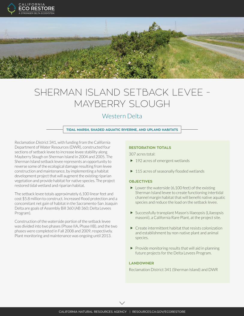
� Lower the waterside (6,100 feet) of the existing Sherman Island levee to create functioning intertidal channel margin habitat that will benefit native aquatic species and reduce the load on the setback levee.
� Successfully transplant Mason’s lilaeopsis (Lilaeopsis masonii), a California Rare Plant, at the project site.
� Create intermittent habitat that resists colonization and establishment by non-native plant and animal species.
� Provide monitoring results that will aid in planning future projects for the Delta Levees Program.
LANDOWNER
Reclamation District 341 (Sherman Island) and DWR
SHERMAN ISLAND SETBACK LEVEE - MAYBERRY SLOUGH
Western Delta
CALIFORNIA NATURAL RESOURCES AGENCY | RESOURCES.CA.GOV/ECORESTORE
FUNDING
� Planning, Design, and Construction - Proposition 84 and General Fund
� Operations and Maintenance – Prop 84 and 1E
TIMELINE
� Design and Plans Completed - 2007
� Landside Construction of Setback Levee - Summer 2008
� First Phase of Waterside Construction completed (2,300 linear feet) - Fall 2008
� Plant Monitoring and Maintenance begins, preparation for second phase of Waterside Construction - Spring 2009
� Second Phase of Waterside Construction completed (3,800 linear feet) - Fall 2009
� Plant Monitoring and Maintenance Completed, Final Report - 2013
� Project completed in 2009
PERMITTING
� CEQA – completed
� USACE 404 – completed
� Clean Water Act Section 401 - completed
� US EPA Stormwater Pollution Prevention Plan - completed
� CVFPB Encroachment Permit – completed
PROJECT PROPONENT
� Bryan Brock, Senior WR Engineer [email protected] (916) 651-0836 Department of Water Resources PO Box 942836 Sacramento, CA 94236
SOLANOCOUNTY
CONTRA COSTACOUNTY
ALAMEDACOUNTY
SAN JOAQUINCOUNTY
YOLOCOUNTY
SUTTERCOUNTY
SACRAMENTOCOUNTY
80
80
505
680
5
5
99
99
12
4
50
CALIFORNIA NATURAL RESOURCES AGENCY | RESOURCES.CA.GOV/ECORESTORE
N
16
0
MILES
5 10 20
CALIFORNIA ECO RESTORE PROJECTS
Knights Landing Outfall Gate
Lindsey Slough
Sherman Island: Mayberry Farms
Sherman Island: Whale’s Mouth
Sherman Island: Mayberry Slough
Twitchell Island: East End
Decker Island
Dutch Slough
Fremont Weir Adult Fish Passage
Hill Slough
McCormack Williamson Tract
Tule Red
Wallace Weir Fish Rescue Facility
Bradmoor Island
Goat Island
Grizzly Slough
Lisbon Weir
Lower Putah Creek Realignment
Lower Yolo Ranch
Prospect Island
Sherman Island: Whale’s Belly
Southport Levee
Twitchell Island: Levee
Twitchell Island: West End
Yolo Bypass Floodplain Restoration
Winter Island
2016 / 2017(Target Construction Start Dates)
2018+(Target Construction Start Dates)
COMPLETED(Construction Completed)
Fish Passage Improvements
Floodplain Restoration
Setback Levee
Subsidence Reversaland Carbon Storage
Tidal Restoration
Yolo Bypass Boundary
Legal Delta and Suisun Marsh Boundaries
Water Bodies
LEGEND
MAYBERRY SLOUGH
Fish Passage Improvements
Floodplain Restora on
Setback Levee
Subsidence Reversaland Carbon Storag e
Tidal Restora n
Yolo Bypass Boundary
Legal Delta and Suisun Marsh Boundaries
Water Bodies
LEGEND