Embed Size (px)
Citation preview
Serpulid Reef survey
Linne Mhuirrich, Loch Sween
November 1999
Owen Paisley Seasearch West Co-ordinator

Serpulid Reef survey in the Linne Mhuirich, Loch Sween
November 6th, 7th and 20th 1999
Contents
1. IntroductionThe Linne Mhuirich1.1
Monitoring Program1.2
Serpulid Reefs1.3
Native Oysters1.4
Eelgrass Beds1.5
Objectives2.
3. MethodologyTiming of the Survey1.1
Site Access1.2
Equipment and Personnel1.3
Position Fixing1.4
Survey Methodology-Serpulid Reefs1.5
Survey Methodology-Native Oysters1.6
Results3 Serpulid Reefs3.1
Native Oysters3.2
Eelgrass beds3.3
Discussion4
Conclusion and recommendations5
7 Acknowledgements
8 References
9 Appendices

Linne Mhuirich Serpulid Reef Survey
November 1999
Plate 1: Relict reef at 2.5 metres
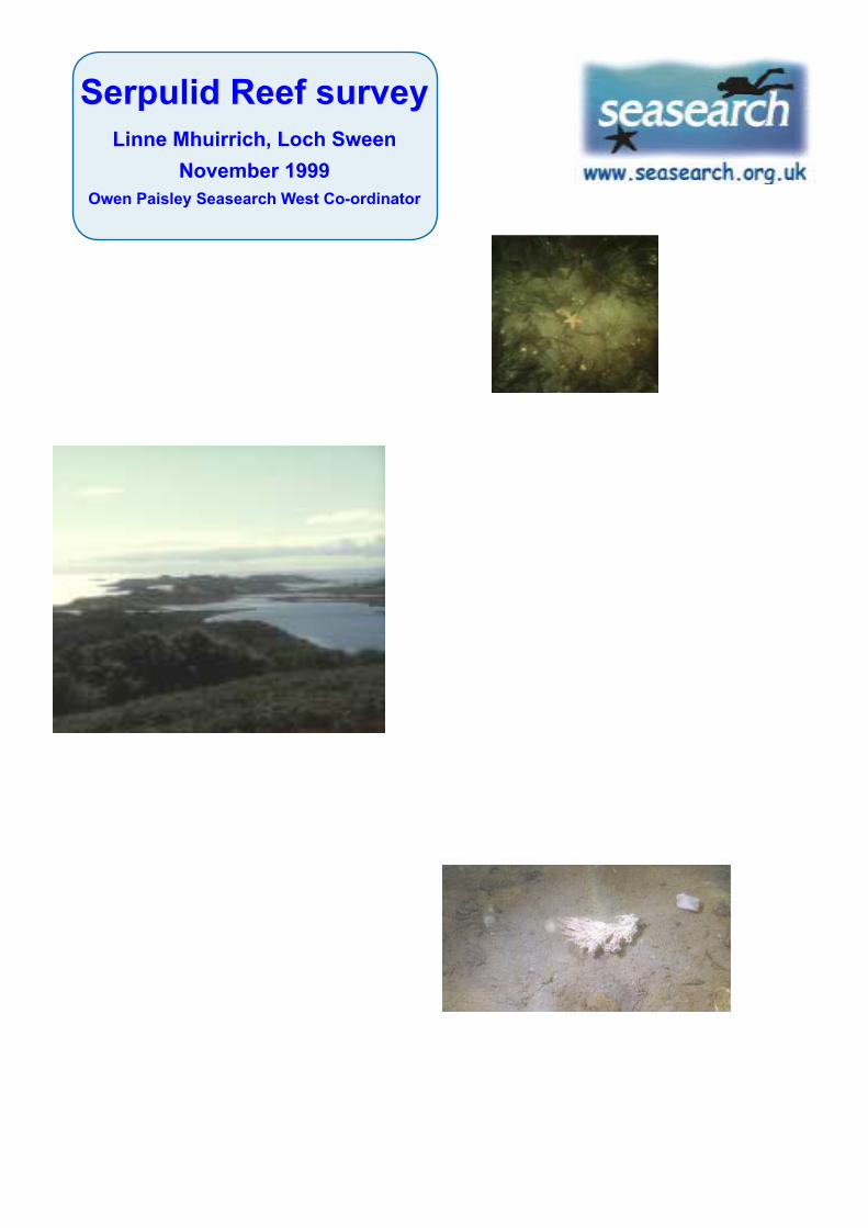
Plate 3: Debris Field at 3 metres
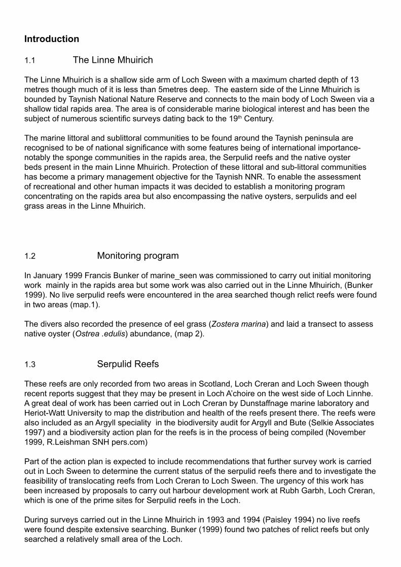
Introduction
1.1 The Linne Mhuirich
The Linne Mhuirich is a shallow side arm of Loch Sween with a maximum charted depth of 13
metres though much of it is less than 5metres deep. The eastern side of the Linne Mhuirich is
bounded by Taynish National Nature Reserve and connects to the main body of Loch Sween via a
shallow tidal rapids area. The area is of considerable marine biological interest and has been the
subject of numerous scientifi c surveys dating back to the 19th Century.
The marine littoral and sublittoral communities to be found around the Taynish peninsula are
recognised to be of national signifi cance with some features being of international importance-
notably the sponge communities in the rapids area, the Serpulid reefs and the native oyster
beds present in the main Linne Mhuirich. Protection of these littoral and sub-littoral communities
has become a primary management objective for the Taynish NNR. To enable the assessment
of recreational and other human impacts it was decided to establish a monitoring program
concentrating on the rapids area but also encompassing the native oysters, serpulids and eel
grass areas in the Linne Mhuirich.
1.2 Monitoring program
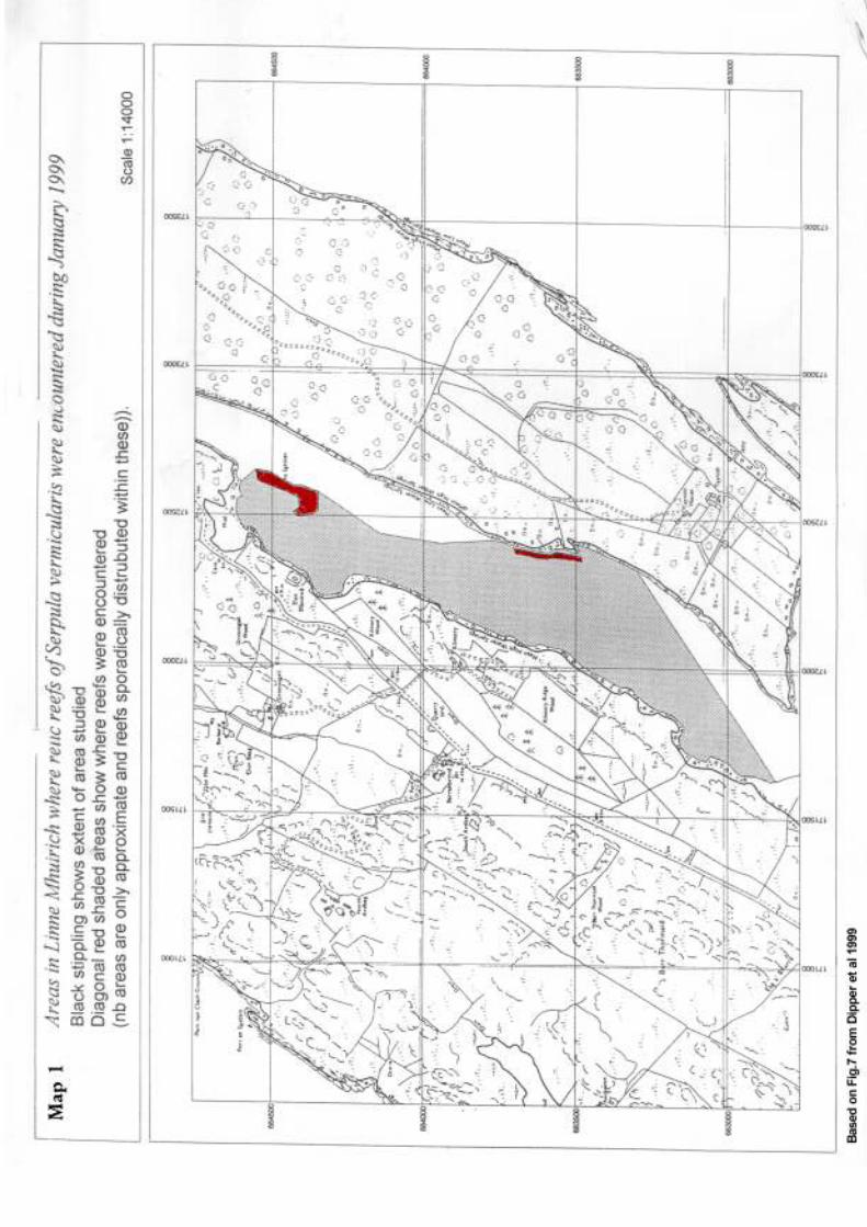
In January 1999 Francis Bunker of marine_seen was commissioned to carry out initial monitoring
work mainly in the rapids area but some work was also carried out in the Linne Mhuirich, (Bunker
1999). No live serpulid reefs were encountered in the area searched though relict reefs were found
in two areas (map.1).
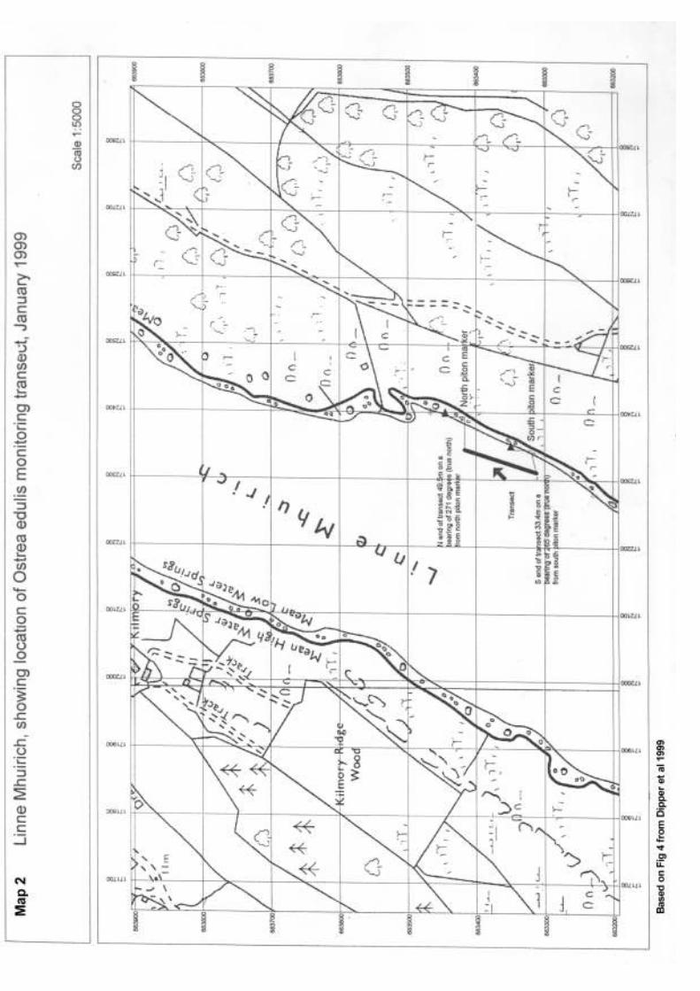
The divers also recorded the presence of eel grass (Zostera marina) and laid a transect to assess
native oyster (Ostrea .edulis) abundance, (map 2).
1.3 Serpulid Reefs
These reefs are only recorded from two areas in Scotland, Loch Creran and Loch Sween though
recent reports suggest that they may be present in Loch A’choire on the west side of Loch Linnhe.
A great deal of work has been carried out in Loch Creran by Dunstaffnage marine laboratory and
Heriot-Watt University to map the distribution and health of the reefs present there. The reefs were
also included as an Argyll speciality in the biodiversity audit for Argyll and Bute (Selkie Associates
1997) and a biodiversity action plan for the reefs is in the process of being compiled (November
1999, R.Leishman SNH pers.com)
Part of the action plan is expected to include recommendations that further survey work is carried
out in Loch Sween to determine the current status of the serpulid reefs there and to investigate the
feasibility of translocating reefs from Loch Creran to Loch Sween. The urgency of this work has
been increased by proposals to carry out harbour development work at Rubh Garbh, Loch Creran,
which is one of the prime sites for Serpulid reefs in the Loch.
During surveys carried out in the Linne Mhuirich in 1993 and 1994 (Paisley 1994) no live reefs
were found despite extensive searching. Bunker (1999) found two patches of relict reefs but only
searched a relatively small area of the Loch.

1.4 Native Oysters (Ostrea edulis)
The Linne Mhuirich is one of the few sites on the west coast known to be supporting a relatively
healthy native oyster population. This has been subject to intermittent collecting for several years
though 1998/99 seemed to be a particularly bad year with oysters being collected during and after
the January 1999 survey work.
2. Objectives
The following objectives for the survey were given by SNH
To carry out a thorough search of the Linne Mhuirich for evidence of Serpulid reefs in areas
which were not surveyed during the Bunker survey.
To carry out a repeat survey along the Ostrea edulis monitoring transect laid by Bunker et al
in January 1999

3 Methodology
3.1 Timing of the Survey
Survey work was initially scheduled to take place during the weekend October 30/31st but had to
be cancelled due to gale force winds and heavy rain. The following weekend proved to be more
amenable and much of the survey was carried out over the weekend of the 6/7th November with
the oyster transect being surveyed on November 20th.
3.2 Access to site
Access to the site was via the Taynish NNR track as far as the SNH sheds and then down through
the fi eld to the shore and an old jetty. The fi eld itself presented few problems but between the
fi eld and the shore there was an area of very boggy ground which was impassable to the vehicles
available. However enough man power was available to push a trailer laden with diving equipment
and boats through the mud and down to the shore. Retrieval of equipment was aided considerably
by the presence of an SNH 4WD vehicle. Even with this vehicle it was necessary to tow the trailer
from the fi eld to the shore using a tow rope as the soft ground made it impossible to take a vehicle
down to the shore.
3.3 Equipment and personnel.
Oban and mid Argyll Scottish Sub-aqua club supplied the personnel necessary for this project. In
all 8 volunteers were involved.
Two infl atable boats were hired by OSAC a 3m Avon Redcrest with a 3Hp engine and a larger
Avon infl atable with a 4Hp engine. These boats were ideal as both they and their engines were
easily carried about. OSAC was also able to provide appropriate safety equipment in the form of
an O2 set and two hand held VHF sets. Additional safety equipment in the form of a fi rst aid kit and
mobile phone was provided by O.Paisley the project organiser.
Personnel for the project were as follows:
Project Organiser Owen Paisley
Dive organiser Angie Rowlands
Divers/snorkellers: John Rees, Dave Hewitt, Phil Rowlands, Trish Grey, Kirsti Reid, Anne
Longbone and Marilyn Franks
3.4 Position Fixing
Positions were fi xed using a Garmin GPS12 (non-differential) hand held unit and then marked
on a photocopied 1:10 000 map supplied by SNH. As the GPS used was a non-differential unit
there was inevitably a variable error in the positions recorded which could on occasion exceed
100metres but was generally much less.
3.5 Serpulid Reef Survey Methodology
The serpulid survey was carried out by divers operating in pairs swimming parallel to the shore
and shadowed by the safety boats. As much of the Linne Mhuirich is very shallow, (< 4 metres)
and the in water visibility >5metres the divers spent much of their time swimming face down on
the surface only descending to check particularly large aggregations of relict reef or possible live

S.vermicularis tubes. When relict reefs or live worms were sighted the divers would inform the
cover boats and the position would be recorded using the handheld GPS. For the very shallow
southern area of the loch surveying was carried out by a snorkel team.
3.6 Native Oyster Survey Methodology
Bunker et al laid out the Ostrea edulis monitoring transect at the position shown on map 2. Either
end of the transect was marked by a small cairn while on land nickel chrome molley steel pitons
were hammered into supra littoral rocks. GPS readings, photographs and video footage were all
taken to aid in re-locating the transect. The transect was 2 metres wide and 108 metres long.
Unfortunately during the present survey no photographs, video footage or GPS readings
were available. Only the northern piton was re-located with neither the dive team not the site
management offi cer being able to re-locate the southern piton. Accordingly the northern end of
the transect was started at a distance of 49.5 metres on a bearing of 271 degrees (True) from the
northern piton, (as recorded in Bunker 1999) . A small pile of stones was found at this point but as
there were several small piles of stones in the vicinity this may or may not have been the original
cairn. One hundred and ten metres of 8mm leaded rope transect line was laid out roughly parallel
to the shore on the bearing indicated on map 2. At around 108m another small pile of stones was
located and this was used as the south end of the transect.
As in the Bunker survey pairs of divers worked with 1m2 quadrats and surveyed a continuous belt
1m either side of the transect line. In each quadrat the number of live oysters was counted. The
presence of live serpulid worms was also recorded as was the presence/absence of eel grass.

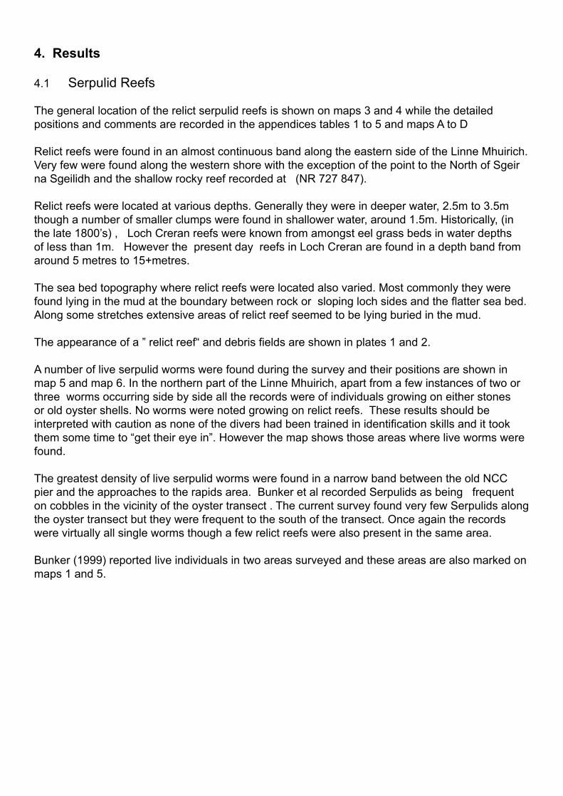
4. Results
4.1 Serpulid Reefs
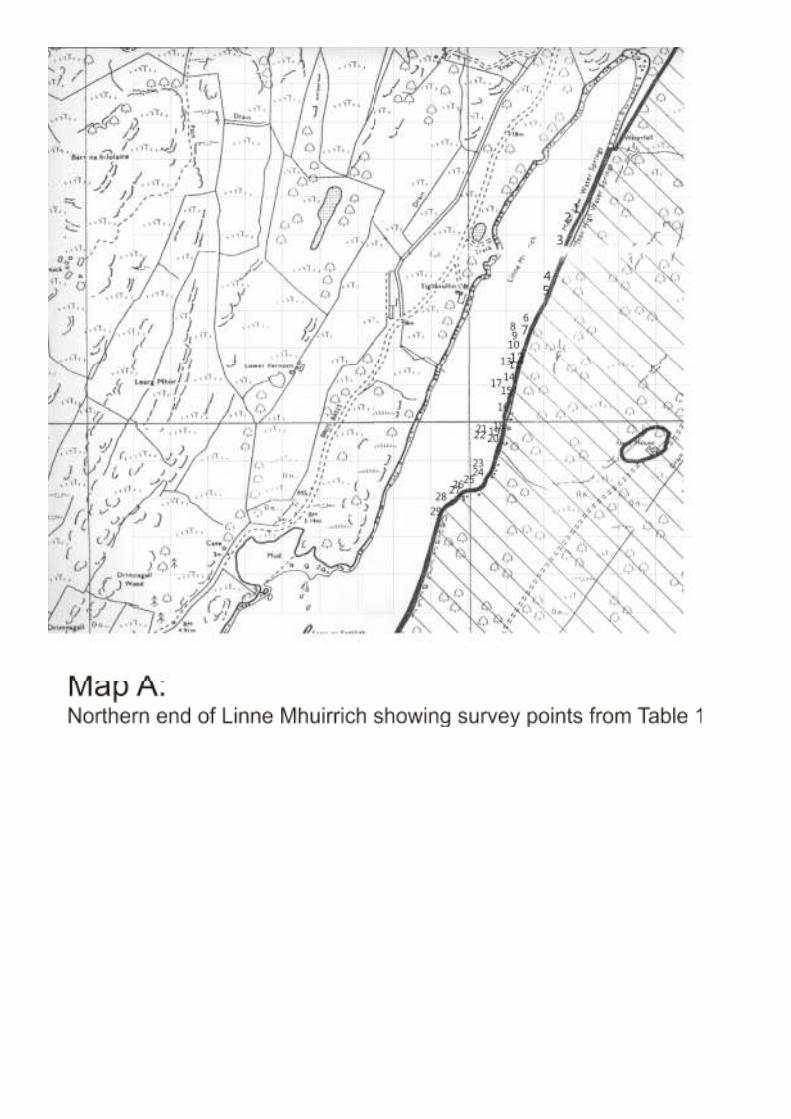
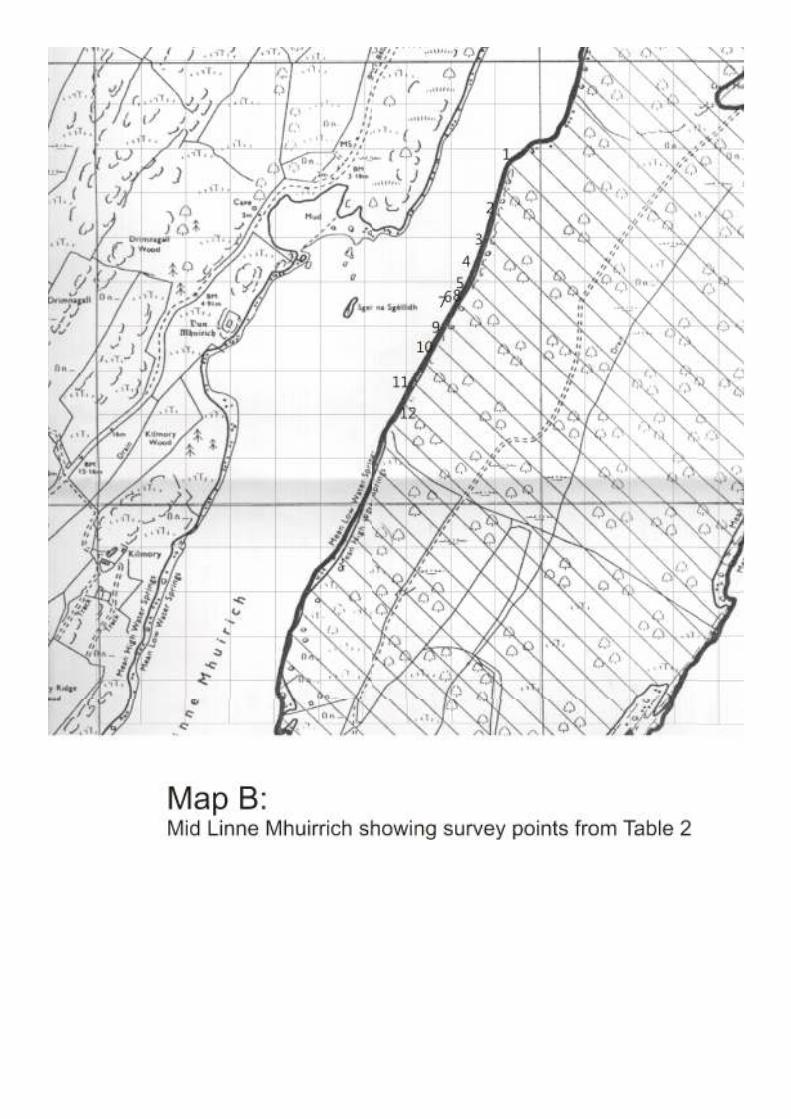
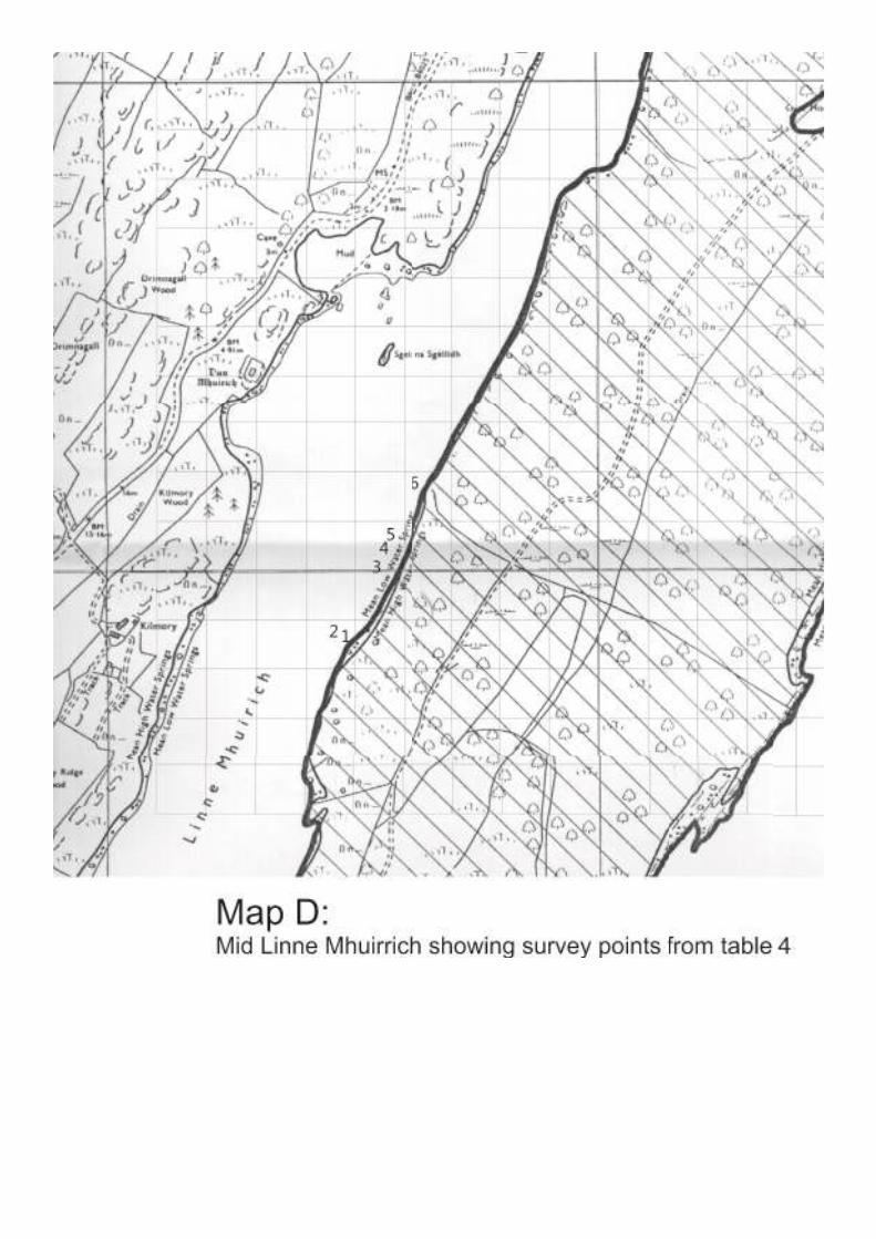
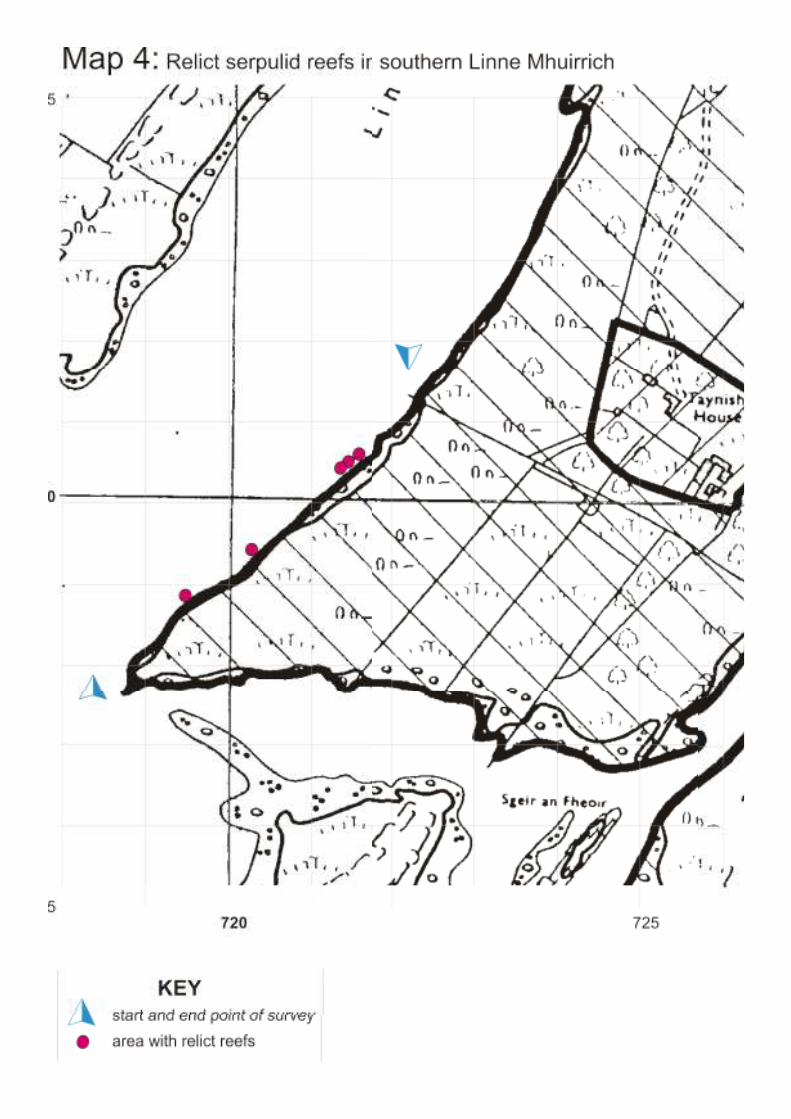
The general location of the relict serpulid reefs is shown on maps 3 and 4 while the detailed
positions and comments are recorded in the appendices tables 1 to 5 and maps A to D
Relict reefs were found in an almost continuous band along the eastern side of the Linne Mhuirich.
Very few were found along the western shore with the exception of the point to the North of Sgeir
na Sgeilidh and the shallow rocky reef recorded at (NR 727 847).
Relict reefs were located at various depths. Generally they were in deeper water, 2.5m to 3.5m
though a number of smaller clumps were found in shallower water, around 1.5m. Historically, (in
the late 1800’s) , Loch Creran reefs were known from amongst eel grass beds in water depths
of less than 1m. However the present day reefs in Loch Creran are found in a depth band from
around 5 metres to 15+metres.
The sea bed topography where relict reefs were located also varied. Most commonly they were
found lying in the mud at the boundary between rock or sloping loch sides and the fl atter sea bed.
Along some stretches extensive areas of relict reef seemed to be lying buried in the mud.
The appearance of a ” relict reef“ and debris fi elds are shown in plates 1 and 2.
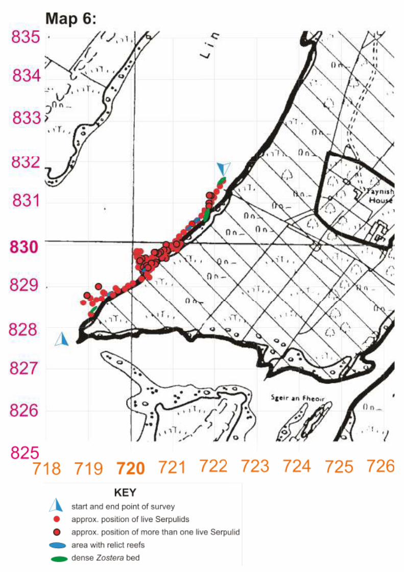
A number of live serpulid worms were found during the survey and their positions are shown in
map 5 and map 6. In the northern part of the Linne Mhuirich, apart from a few instances of two or
three worms occurring side by side all the records were of individuals growing on either stones
or old oyster shells. No worms were noted growing on relict reefs. These results should be
interpreted with caution as none of the divers had been trained in identifi cation skills and it took
them some time to “get their eye in”. However the map shows those areas where live worms were
found.
The greatest density of live serpulid worms were found in a narrow band between the old NCC
pier and the approaches to the rapids area. Bunker et al recorded Serpulids as being frequent
on cobbles in the vicinity of the oyster transect . The current survey found very few Serpulids along
the oyster transect but they were frequent to the south of the transect. Once again the records
were virtually all single worms though a few relict reefs were also present in the same area.
Bunker (1999) reported live individuals in two areas surveyed and these areas are also marked on
maps 1 and 5.

4.2 Native Oysters
At the end of the survey the divers recorded a length of 105 metres which indicates that the
transect was not laid in exactly the same position as previously or that it stopped short of the
previous transect end. However positioning of the northern end of the transect was as accurate as
possible, the depth of the transect , (less than 1metre), was much the same as in Bunker (1999)
and the type of sea bed encountered was similar to the previous study. If the transect was not in
exactly in the same place as previously it was very close.
The results of the transect are shown in the appendices,Tables 6 and 7. A mean density of 0.72
oysters per m2 was recorded , compared to 1.3 per m2 recorded by Bunker. The number of
oysters per quadrat varied from 0 to 5 (Bunker recorded 0 to 9)
4.3 Zostera marina beds
Several areas of eel grass were noted during the survey with the largest bed being an extensive
area at the northern end of the Linne Mhuirich. Eel grass was also abundant in the south eastern
area of the loch. Elsewhere there was a fringe of eel grass at a depth of 1 to 1.5 metres around
much of the area surveyed. Details of eel grass records are included in tables 1 to 7 in the
appendices. Eel grass was also present in the Ostrea monitoring transect and is recorded in fi g 1.
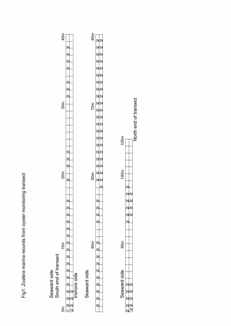
Fig
1:
Zoste
ra m
arina
record
s fro
m o
yste
r m
onitoring tra
nsect
Seaw
ard
sid
e
South
end o
f tr
ansect
0m
1
0m
2
0m
3
0m
40m
zz
zz
zz
zz
zz
zz
zz
zz
zz
zz
zz
zz
zz
zz
zz
zz
Inshore
sid
e
Seaw
ard
sid
e
5
0m
60m
70m
80m
zz
zz
zz
zz
zz
zz
zz
zz
zz
zz
zz
zz
zz
zz
zz
zz
zz
zz
zz
zz
zz
zz
zz
zz
zz
zz
zz
zz
z
Seaw
ard
sid
e
90m
1
00m
105m
zz
zz
zz
zz
zz
zz
zz
zz
zz
zz
N
ort
h e
nd o
f tr
ansect

Discussion5.
Serpula vermicularis5.1 reef studies
The main aim of this survey was to determine the current status of Serpulid reefs in the Linne
Mhuirich arm of Loch Sween. Divers and snorkellers surveyed all of the arm apart from the area
surveyed by Bunker earlier in the year. No live reefs were found and it seems highly unlikely that
any still survive within the loch. Relict reefs were common along the eastern shore of the loch
both north and south of the area surveyed by Bunker et al. A few solitary live Serpulids were noted
in the northern part of the loch but the highest concentration of live worms were found between
the old NCC pier and the approaches to the rapids area. Virtually all the live worms were located
in very shallow water , around 1m on cobbles, rock or old oyster shells with the highest density
recorded around NR 7205 8295 The presence of a few relict reefs in this area alongside frequent
live reefs is of interest. This area should be surveyed at annual intervals as it seems the most
likely spot for the reefs to re-form.
If at some future date it was decided to translocate serpulid reefs from Loch Creran to the Linne
Mhuirrich a potential site would be in the deeper water around the point at NR 7295 8480. Relict
reefs were common on both sides of the Loch at this point and the deeper water in this area would
provide some protection from changes in water quality.
However as there is an apparently healthy population of Serpulid worms in the southern part of the
loch it may be that, given suffi cient time, the reefs will re-form of their own accord.
Ostrea edulis5.2 monitoring transect
The number of oysters recorded was approximately half that recorded in January 1999, (0.72per
m2 compared with 1.3 per m2) . As has been mentioned there is some doubt that the transect
was re-laid in exactly the same position as previously. However the northern end of the transect
was located accurately and it is the position of the southern end which was open to doubt. If
the records in Tables 6 and 7 are considered it can be seen that most of the oysters seen were
recorded in the southern half of the transect (mean density 1.03 m2 in the fi rst 100 quadrats) and
it was the counts in the northern end of the transect which brought down the mean density to 0.72
per m2. As the northern end of the transect was laid accurately this suggests that there has been
a genuine drop in native oyster abundance in the transect area.
Native oysters were found in scattered pockets throughout the Linne Mhuirrich with some of the
highest densities in the less accessible northern area.
Zostera marina5.3
The eel grass beds appear to be healthy with quite large areas found at the northern and south-
western ends of the Loch. The abundance and density of eel grass beds seen by the project
organiser seem very similar to those noted during previous survey work in 1993 and 1994. More
eel grass was recorded in the Ostrea edulis transect than previously but this may simply be due to
the timing of this survey, autumn rather than mid winter.
6 Conclusions and recommendations
It is highly unlikely that there are any live 1) Serpula vermicularis reefs within the Linne Mhuirrich.
The highest density of live 2) S.vermicularis occurred in the southern part of the Loch between
the old NCC pier and the rapids.
Native Oysters were found throughout the Loch with the highest densities in the less accessible 3)
Northern parts of the Loch.
The mean density of oysters recorded along the monitoring transect was 0.72per m4) 2
compared with 1.3 per m2 in the January 1999 survey.
Extensive and apparently healthy eel grass beds are found at the head of the Linne Mhuirrich 5)
and at the southern end.
Recommendations
The area to the south of the NCC pier should be re-surveyed at annual intervals for any 1)
evidence of serpulid reef re-generation.
If it is decided to attempt translocating reefs from Loch Creran to the Linne Mhuirrich the area 2)
around the point at NR 7295 8480 is probably the best site.
Some diffi culty was experienced locating the oyster monitoring transect. The transect should 3)
be marked underwater using a dexian frame which should last several years in the sheltered
conditions. It would also help if copies of the photographs showing the piton locations were
held in the Kilmory offi ce of SNH.
The intensive oyster harvesting taking place in the Linne Mhuirrich over 1999 seems to have
effectively halved the oyster density in the study area. In order to detect any future trends the
oyster transect should be surveyed on an annual basis with a second transect being installed in
the less accessible northern area of the loch.
7 Acknowledgements
I would like to thank the following for their help during the fi eld survey:
Angie Rowlands for organising the diving and ensuring that enough people were present to carry
out each days work.
John Halliday of SNH for arriving with a four wheel drive and extricating trailer and diving
equipment from the fi eld.
Alistair Davison of SNH for taking the time and trouble to bring me up to date with HSE legislation
and its requirements.
The members of the survey team for carrying out the work required of them in often unpleasant
conditions. Without their good humoured help this survey would have been impossible. They
were: Marilyn Franks, Trish Grey, Dave Hewitt, Anne Longbone, John Rees, Kirsti Reid and Phil
Rowlands.
8 References
Bunker, F.St.P.D (1999) Monitoring within Linne Mhuirich and Rapids in January 1999. A report
from marine_seen, Estuary Cottage, Bentlass, Hundleton, Pembrokeshire,
SA71 5RN, Wales UK
Paisley, O (1994) Loch Sween Project Report 1992-1994
Selkie Associates (1997) Biodiversity in Argyll and Bute-a preliminary audit of priority habitats
and species
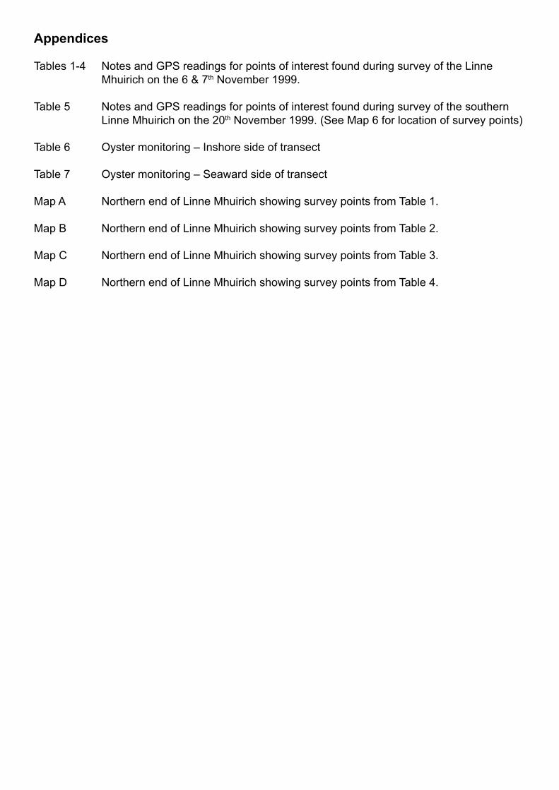
Appendices
Tables 1-4 Notes and GPS readings for points of interest found during survey of the Linne
Mhuirich on the 6 & 7th November 1999.
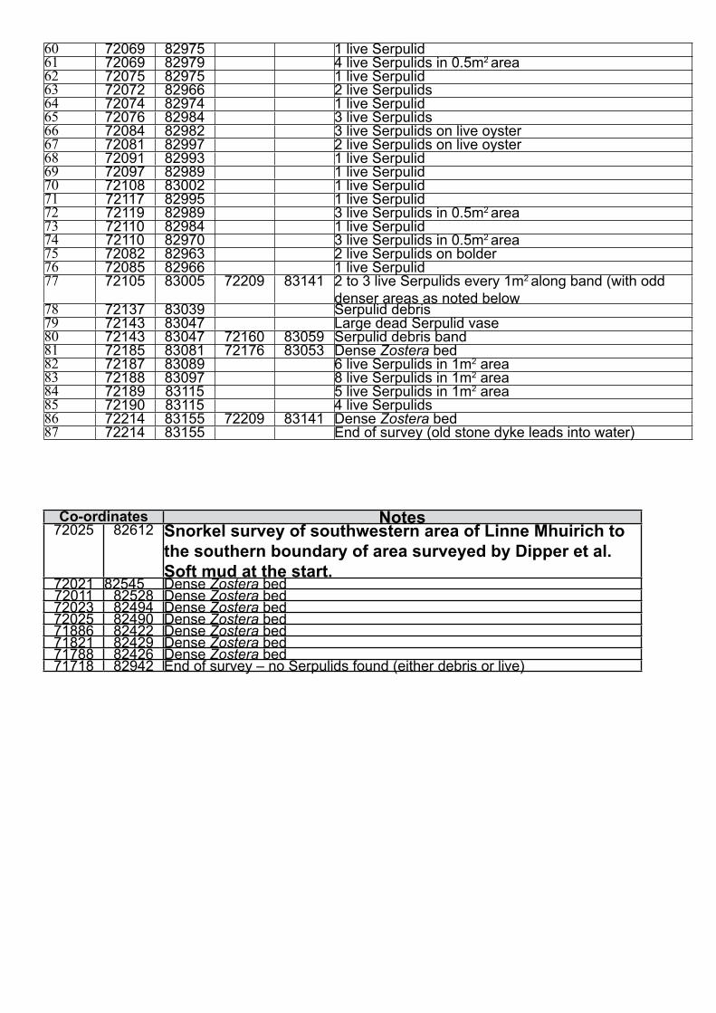
Table 5 Notes and GPS readings for points of interest found during survey of the southern
Linne Mhuirich on the 20th November 1999. (See Map 6 for location of survey points)
Table 6 Oyster monitoring – Inshore side of transect
Table 7 Oyster monitoring – Seaward side of transect
Map A Northern end of Linne Mhuirich showing survey points from Table 1.
Map B Northern end of Linne Mhuirich showing survey points from Table 2.
Map C Northern end of Linne Mhuirich showing survey points from Table 3.
Map D Northern end of Linne Mhuirich showing survey points from Table 4.
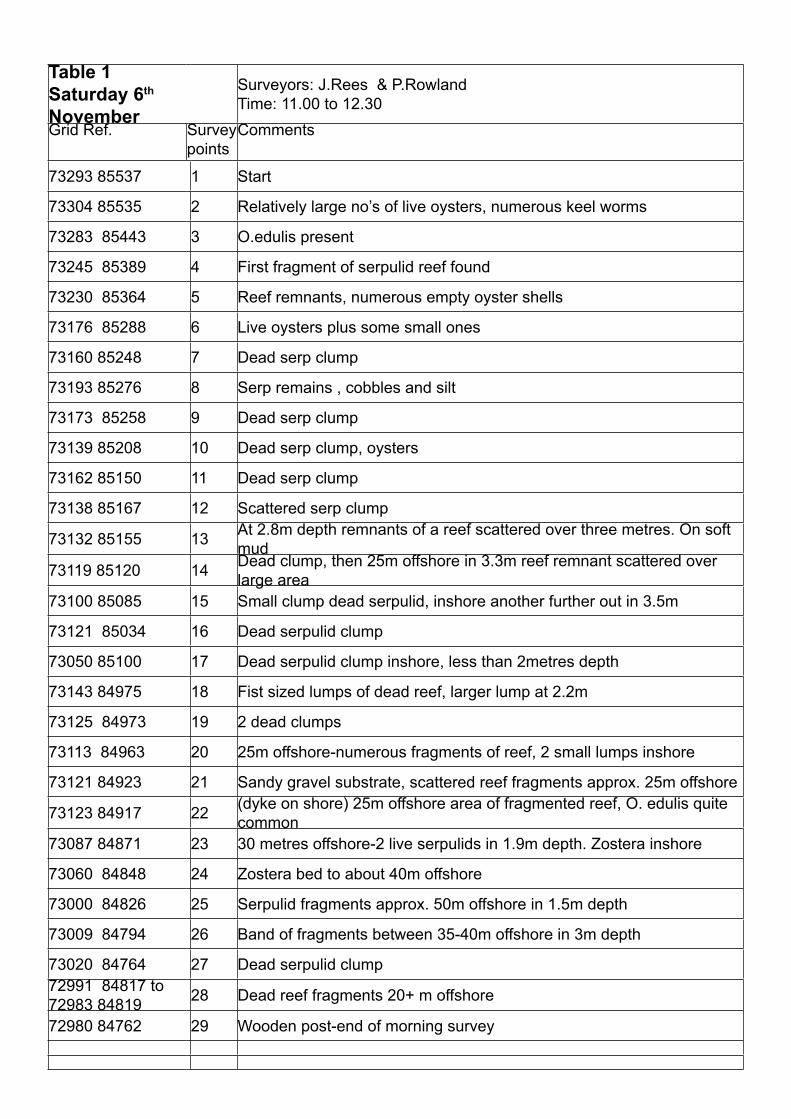
Table 1
Saturday 6th
November
Surveyors: J.Rees & P.Rowland
Time: 11.00 to 12.30
Grid Ref. Survey
points
Comments
73293 85537 1 Start
73304 85535 2 Relatively large no’s of live oysters, numerous keel worms
73283 85443 3 O.edulis present
73245 85389 4 First fragment of serpulid reef found
73230 85364 5 Reef remnants, numerous empty oyster shells
73176 85288 6 Live oysters plus some small ones
73160 85248 7 Dead serp clump
73193 85276 8 Serp remains , cobbles and silt
73173 85258 9 Dead serp clump
73139 85208 10 Dead serp clump, oysters
73162 85150 11 Dead serp clump
73138 85167 12 Scattered serp clump
73132 85155 13At 2.8m depth remnants of a reef scattered over three metres. On soft
mud
73119 85120 14Dead clump, then 25m offshore in 3.3m reef remnant scattered over
large area
73100 85085 15 Small clump dead serpulid, inshore another further out in 3.5m
73121 85034 16 Dead serpulid clump
73050 85100 17 Dead serpulid clump inshore, less than 2metres depth
73143 84975 18 Fist sized lumps of dead reef, larger lump at 2.2m
73125 84973 19 2 dead clumps
73113 84963 20 25m offshore-numerous fragments of reef, 2 small lumps inshore
73121 84923 21 Sandy gravel substrate, scattered reef fragments approx. 25m offshore
73123 84917 22(dyke on shore) 25m offshore area of fragmented reef, O. edulis quite
common
73087 84871 23 30 metres offshore-2 live serpulids in 1.9m depth. Zostera inshore
73060 84848 24 Zostera bed to about 40m offshore
73000 84826 25 Serpulid fragments approx. 50m offshore in 1.5m depth
73009 84794 26 Band of fragments between 35-40m offshore in 3m depth
73020 84764 27 Dead serpulid clump
72991 84817 to
72983 8481928 Dead reef fragments 20+ m offshore
72980 84762 29 Wooden post-end of morning survey
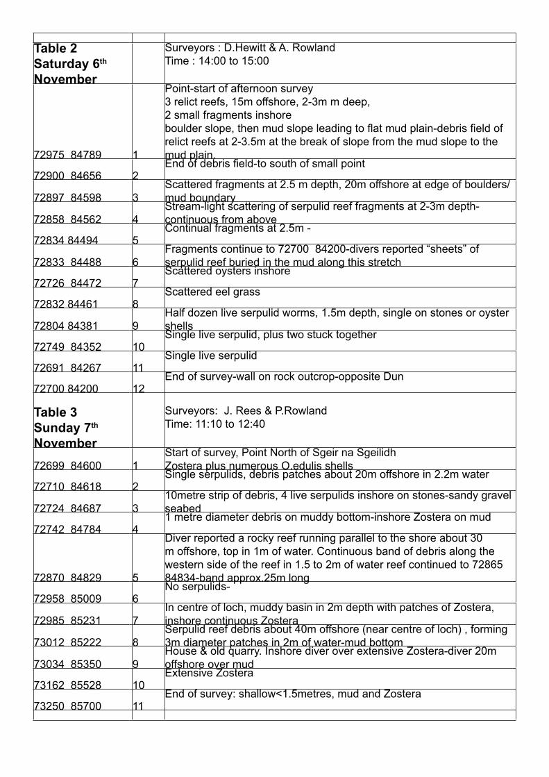
Table 2
Saturday 6th
November
Surveyors : D.Hewitt & A. Rowland
Time : 14:00 to 15:00
72975 84789 1
Point-start of afternoon survey
3 relict reefs, 15m offshore, 2-3m m deep,
2 small fragments inshore
boulder slope, then mud slope leading to fl at mud plain-debris fi eld of
relict reefs at 2-3.5m at the break of slope from the mud slope to the
mud plain.
72900 84656 2End of debris fi eld-to south of small point
72897 84598 3
Scattered fragments at 2.5 m depth, 20m offshore at edge of boulders/
mud boundary
72858 84562 4
Stream-light scattering of serpulid reef fragments at 2-3m depth-
continuous from above
72834 84494 5Continual fragments at 2.5m -
72833 84488 6
Fragments continue to 72700 84200-divers reported “sheets” of
serpulid reef buried in the mud along this stretch
72726 84472 7Scattered oysters inshore
72832 84461 8Scattered eel grass
72804 84381 9
Half dozen live serpulid worms, 1.5m depth, single on stones or oyster
shells
72749 84352 10Single live serpulid, plus two stuck together
72691 84267 11Single live serpulid
72700 84200 12End of survey-wall on rock outcrop-opposite Dun
Table 3
Sunday 7th
November
Surveyors: J. Rees & P.Rowland
Time: 11:10 to 12:40
72699 84600 1
Start of survey, Point North of Sgeir na Sgeilidh
Zostera plus numerous O.edulis shells
72710 84618 2Single serpulids, debris patches about 20m offshore in 2.2m water
72724 84687 3
10metre strip of debris, 4 live serpulids inshore on stones-sandy gravel
seabed
72742 84784 41 metre diameter debris on muddy bottom-inshore Zostera on mud
72870 84829 5
Diver reported a rocky reef running parallel to the shore about 30
m offshore, top in 1m of water. Continuous band of debris along the
western side of the reef in 1.5 to 2m of water reef continued to 72865
84834-band approx.25m long
72958 85009 6No serpulids-
72985 85231 7
In centre of loch, muddy basin in 2m depth with patches of Zostera,
inshore continuous Zostera
73012 85222 8
Serpulid reef debris about 40m offshore (near centre of loch) , forming
3m diameter patches in 2m of water-mud bottom
73034 85350 9
House & old quarry. Inshore diver over extensive Zostera-diver 20m
offshore over mud
73162 85528 10Extensive Zostera
73250 85700 11End of survey: shallow<1.5metres, mud and Zostera

Table 4
Sunday 7th
November
Surveyors: D. Hewitt & T.Grey
Time 15:00 to 15:35
72495 83811 1 Small point to North of landing beach-strip of eel grass 5m offshore
72485 83807 2 Steep slope to 4m @ 20m offshore-few fragments to 72?91 83942
72521 83983 3 1 live serpulid-more fragments of old reef
72518 84003 4 From above-continual debris fi eld at 2.6m
72520 84085 5 2 live serpulids
72568 84189 6Continual debris fi eld from above at 2.5m, several live serpulids along
this stretch-end at wall on rock.
From landing beach south towards rapids-snorkellers found a continual
debris fi eld including several intact 30+cm dead reef fans.
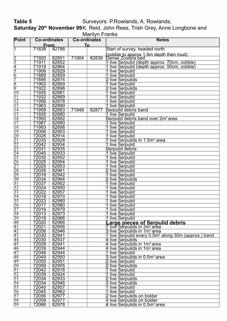
Table 5 Surveyors: P.Rowlands, A. Rowlands,
Saturday 20th November 99 K. Reid, John Rees, Trish Grey, Anne Longbone and
Marilyn FranksPoint Co-ordinates
From
Co-ordinates
To
Notes
1 71838 82786 Start of survey, headed north
(cobble to approx 1.5m depth then mud)2 71920 82851 71904 82836 Dense Zostera bed3 71911 82852 1 live Serpulid (depth approx. 70cm, cobble)4 71919 82864 1 live Serpulid (depth approx. 50cm, cobble)5 71906 82829 1 live Serpulid6 71889 82859 1 live Serpulid7 71896 82874 2 live Serpulids8 71902 82869 1 live Serpulid9 71922 82896 2 live Serpulids10 71935 82881 1 live Serpulid11 71932 82869 1 live Serpulid12 71956 82878 1 live Serpulid13 71963 82890 1 live Serpulid14 71958 82883 71948 82877 Serpulid debris band15 71935 82880 1 live Serpulid16 71950 82882 Serpulid debris band over 2m2 area17 71987 82880 1 live Serpulid18 71993 82898 1 live Serpulid19 72006 82903 1 live Serpulid20 72026 82914 1 live Serpulid21 72035 82928 7 live Serpulids in 1.5m2 area22 72042 82934 1 live Serpulid23 72031 82935 Serpulid debris24 72045 82933 1 live Serpulid25 72030 82952 1 live Serpulid26 72025 82954 1 live Serpulid27 72029 82953 1 live Serpulid28 72026 82961 2 live Serpulid29 72018 82942 1 live Serpulid30 72034 82964 2 live Serpulids31 72037 82952 1 live Serpulid32 72024 82950 1 live Serpulid33 72022 82957 1 live Serpulid34 72018 82970 1 live Serpulid35 72023 82980 1 live Serpulid36 72017 82980 1 live Serpulid37 72016 82979 1 live Serpulid38 72013 82973 1 live Serpulid39 72018 82966 1 live Serpulid40 72020 82966 Large pieces of Serpulid debris41 72021 82956 7 live Serpulids in 3m2 area42 72056 82946 3 live Serpulids in 1m2 area43 72030 82941 1 live Serpulid every 0.5m2 along 30m (approx.) band44 72030 82937 4 live Serpulids45 72028 82941 4 live Serpulids in 1m2 area46 72039 82944 4 live Serpulids in 1m2 area47 72048 82944 1 live Serpulid48 72049 82950 3 live Serpulids in 0.5m2 area49 72055 82951 2 live Serpulid50 72059 82955 2 live Serpulids51 72042 82918 1 live Serpulid52 72039 82924 1 live Serpulid53 72034 82933 2 live Serpulids54 72034 82946 3 live Serpulids55 72040 82957 1 live Serpulid56 72045 82962 1 live Serpulid57 72056 82977 2 live Serpulids on bolder58 72059 82977 4 live Serpulids on bolder59 72066 82978 4 live Serpulids in 0.5m2 area
60 72069 82975 1 live Serpulid61 72069 82979 4 live Serpulids in 0.5m2 area62 72075 82975 1 live Serpulid63 72072 82966 2 live Serpulids64 72074 82974 1 live Serpulid65 72076 82984 3 live Serpulids66 72084 82982 3 live Serpulids on live oyster67 72081 82997 2 live Serpulids on live oyster68 72091 82993 1 live Serpulid69 72097 82989 1 live Serpulid70 72108 83002 1 live Serpulid71 72117 82995 1 live Serpulid72 72119 82989 3 live Serpulids in 0.5m2 area73 72110 82984 1 live Serpulid74 72110 82970 3 live Serpulids in 0.5m2 area75 72082 82963 2 live Serpulids on bolder76 72085 82966 1 live Serpulid77 72105 83005 72209 83141 2 to 3 live Serpulids every 1m2 along band (with odd
denser areas as noted below78 72137 83039 Serpulid debris79 72143 83047 Large dead Serpulid vase80 72143 83047 72160 83059 Serpulid debris band81 72185 83081 72176 83053 Dense Zostera bed82 72187 83089 6 live Serpulids in 1m2 area83 72188 83097 8 live Serpulids in 1m2 area84 72189 83115 5 live Serpulids in 1m2 area85 72190 83115 4 live Serpulids86 72214 83155 72209 83141 Dense Zostera bed87 72214 83155 End of survey (old stone dyke leads into water)
Co-ordinates Notes72025 82612 Snorkel survey of southwestern area of Linne Mhuirich to
the southern boundary of area surveyed by Dipper et al.
Soft mud at the start.72021 82545 Dense Zostera bed72011 82528 Dense Zostera bed72023 82494 Dense Zostera bed72025 82490 Dense Zostera bed71886 82422 Dense Zostera bed71821 82429 Dense Zostera bed71788 82426 Dense Zostera bed71718 82942 End of survey – no Serpulids found (either debris or live)
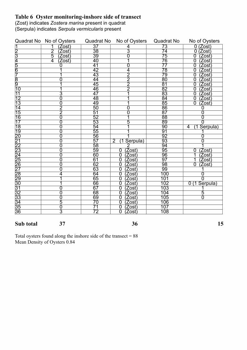
Table 6 Oyster monitoring-inshore side of transect(Zost) indicates Zostera marina present in quadrat
(Serpula) indicates Serpula vermicularis present
Quadrat No No of Oysters Quadrat No No of Oysters Quadrat No No of Oysters1 1 (Zost) 37 4 73 0 (Zost)2 2 (Zost) 38 3 74 0 (Zost)3 5 (Zost) 39 0 75 0 (Zost)4 4 (Zost) 40 1 76 0 (Zost)5 0 41 0 77 0 (Zost)6 1 42 4 78 0 (Zost)7 1 43 2 79 0 (Zost)8 0 44 2 80 0 (Zost)9 1 45 2 81 0 (Zost)10 1 46 2 82 0 (Zost)11 3 47 1 83 0 (Zost)12 0 48 1 84 0 (Zost)13 0 49 1 85 0 (Zost)14 2 50 0 86 015 2 51 0 87 016 0 52 1 88 017 0 53 5 89 018 0 54 1 90 4 (1 Serpula)19 0 55 1 91 120 0 56 1 92 021 0 57 2 (1 Serpula) 93 022 0 58 2 94 123 0 59 0 (Zost) 95 0 (Zost)24 0 60 0 (Zost) 96 1 (Zost)25 0 61 0 (Zost) 97 1 (Zost)26 0 62 0 (Zost) 98 0 (Zost)27 0 63 0 (Zost) 99 128 4 64 0 (Zost) 100 029 1 65 0 (Zost) 101 030 1 66 0 (Zost) 102 0 (1 Serpula)31 0 67 0 (Zost) 103 132 0 68 0 (Zost) 104 533 0 69 0 (Zost) 105 034 5 70 0 (Zost) 10635 0 71 0 (Zost) 10736 3 72 0 (Zost) 108
Sub total 37 36 15
Total oysters found along the inshore side of the transect = 88
Mean Density of Oysters 0.84
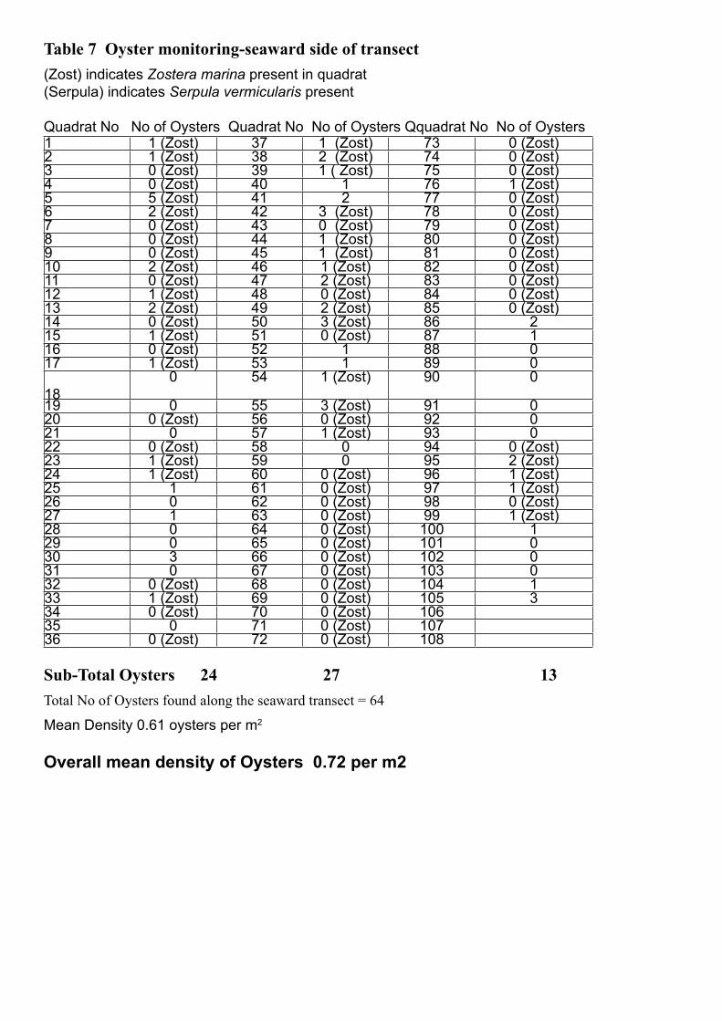
Table 7 Oyster monitoring-seaward side of transect
(Zost) indicates Zostera marina present in quadrat
(Serpula) indicates Serpula vermicularis present
Quadrat No No of Oysters Quadrat No No of Oysters Qquadrat No No of Oysters1 1 (Zost) 37 1 (Zost) 73 0 (Zost)2 1 (Zost) 38 2 (Zost) 74 0 (Zost)3 0 (Zost) 39 1 ( Zost) 75 0 (Zost)4 0 (Zost) 40 1 76 1 (Zost)5 5 (Zost) 41 2 77 0 (Zost)6 2 (Zost) 42 3 (Zost) 78 0 (Zost)7 0 (Zost) 43 0 (Zost) 79 0 (Zost)8 0 (Zost) 44 1 (Zost) 80 0 (Zost)9 0 (Zost) 45 1 (Zost) 81 0 (Zost)10 2 (Zost) 46 1 (Zost) 82 0 (Zost)11 0 (Zost) 47 2 (Zost) 83 0 (Zost)12 1 (Zost) 48 0 (Zost) 84 0 (Zost)13 2 (Zost) 49 2 (Zost) 85 0 (Zost)14 0 (Zost) 50 3 (Zost) 86 215 1 (Zost) 51 0 (Zost) 87 116 0 (Zost) 52 1 88 017 1 (Zost) 53 1 89 0
18
0 54 1 (Zost) 90 0
19 0 55 3 (Zost) 91 020 0 (Zost) 56 0 (Zost) 92 021 0 57 1 (Zost) 93 022 0 (Zost) 58 0 94 0 (Zost)23 1 (Zost) 59 0 95 2 (Zost)24 1 (Zost) 60 0 (Zost) 96 1 (Zost)25 1 61 0 (Zost) 97 1 (Zost)26 0 62 0 (Zost) 98 0 (Zost)27 1 63 0 (Zost) 99 1 (Zost)28 0 64 0 (Zost) 100 129 0 65 0 (Zost) 101 030 3 66 0 (Zost) 102 031 0 67 0 (Zost) 103 032 0 (Zost) 68 0 (Zost) 104 133 1 (Zost) 69 0 (Zost) 105 334 0 (Zost) 70 0 (Zost) 10635 0 71 0 (Zost) 10736 0 (Zost) 72 0 (Zost) 108
Sub-Total Oysters 24 27 13
Total No of Oysters found along the seaward transect = 64
Mean Density 0.61 oysters per m2
Overall mean density of Oysters 0.72 per m2