Embed Size (px)
Citation preview

Geomorphology 203 (2013) 97–104
Contents lists available at ScienceDirect
Geomorphology
j ourna l homepage: www.e lsev ie r .com/ locate /geomorph
Sedimentological and geomorphological imprints of Holocene tsunamisin southwestern Spain: An approach to establish the recurrence period
Francisco Ruiz a,⁎, Joaquín Rodríguez-Vidal a,Manuel Abad a, LuisM. Cáceres a,María I. Carretero b,Manuel Pozo c,José M. Rodríguez-Llanes d, Francisco Gómez-Toscano e, Tatiana Izquierdo f, Eric Font g, Antonio Toscano a
a Departamento de Geodinámica y Paleontología, Campus del Carmen, Universidad de Huelva, 21071 Huelva, Spainb Departamento de Cristalografía, Mineralogía y Química Agrícola, Universidad de Sevilla, 41071 Sevilla, Spainc Departamento de Geología y Geoquímica, Universidad Autónoma de Madrid, Madrid, Spaind Centre for Research on the Epidemiology of Disasters, Institute of Health and Society, Université catholique de Louvain, 1200 Brussels, Belgiume Departamento de Historia I, Campus del Carmen, Universidad de Huelva, 21071 Huelva, Spainf Centro de Vulcanologia e Avaliação de Riscos Geológicos, Universidade dos Açores, 9500-321 Ponta Delgada, Portugalg IDL-FCUL, Faculdade de Ciencias de Lisboa, Campo Grande, 1749-016 Lisboa, Portugal
⁎ Corresponding author.E-mail address: [email protected] (F. Ruiz).
0169-555X/$ – see front matter © 2013 Elsevier B.V. All rhttp://dx.doi.org/10.1016/j.geomorph.2013.09.008
a b s t r a c t
a r t i c l e i n f oArticle history:Received 2 March 2012Received in revised form 29 August 2013Accepted 10 September 2013Available online 10 October 2013
Keywords:GeomorphologyTsunamiRecurrenceHoloceneSW Spain
This paper reviews the sedimentological and geomorphological imprints of prehistoric and historical tsunamis inthe four main estuaries of SW Spain. These imprints include beach erosion, filling of intertidal channels,deposition of bioclastic layers, washover fans and reworked aeolian sheets and the breaching of spits andtombolos. Most of these imprints were caused by the 218–209 BC and AD1755 tsunamis, although evidence ofother tsunamis has been identified. In these two events, effects on human populations were severe and diverse,such as human loss of life, changes in coastal settlements and international borders, damage toport infrastructureor flooding of marsh and inhabited areas. New radiocarbon reservoir data were included in order to obtain anapproach to the recurrence period of these high-energy events (700–1000 years) in this area.
© 2013 Elsevier B.V. All rights reserved.
1. Introduction
In recent years, numerous investigations have focused on thegeomorphic evidence of the 2004 Indian Ocean tsunami along the coastsof Indonesia, Thailand andSri Lanka. These imprints include the formationof new inlets and the breaching of barrier islands (Mascarenhas, 2006),extensive erosion in river mouths and tidal channels (Szczucinski et al.,2006), return channels (Fagherazzi and Du, 2008) or area reduction inreef islands (Kench et al., 2008). In this sense, the post-tsunami effectshave been extensively analysed through the comparison of pre- andpost-tsunami data and satellite imagery in order to calculate coastalrecovery (Choowong et al., 2009; Liew et al., 2010) or bathymetricchanges in the nearshore zone (Goto et al., 2011). The general conclusionis that this event caused strong geomorphic changes (Paris et al., 2009),which has played a determinant role in the subsequent development ofthese areas (e.g. Siwar et al., 2006).
Lessons from this tsunami have been applied to the geological recordand have resulted in interesting findings. Multi-proxy analyses ofsediment cores helped to identify palaeotsunamis, with the recognitionof tsunamigenic facies and their sedimentological, mineralogical,
ights reserved.
geochemical and micropalaeontological features (Monecke et al.,2008; Goff et al., 2010).
In this paper, we summarize the main sedimentological andgeomorphological imprints of Holocene tsunamis in the main fourestuaries of southwestern Spain and their implications for humansettlements and activities during historical times. In addition, a newapproach to estimate the recurrence period of these high-energy eventsis proposed.
2. Study area
2.1. General features
In the southwestern Spanish coast (Fig. 1), four main estuaries maybedifferentiated on a clastic Plio–Pleistocene substrate: (1) theGuadianaEstuary, composed of a main channel (5–15m depth) and broad marshdeposits protected by sandy spits and separated by distributary channelsnear the mouth (Fig. 2A); (2) the Tinto–Odiel Estuary (Fig. 3A), with amarine sector constituted by two main channels that separate salt-marsh deposits; (3) the Guadalquivir Estuary (Fig. 4A), partially closedby two spits (Doñana and La Algaida) that protect the Doñana NationalPark, a biosphere reserve (N50,000 ha) with a sedimentary recordfrom the Lower Pliocene to the Late Holocene (Salvany et al., 2011);and (4) the Guadalete Estuary (Fig. 4F), roughly circular and separated

Fig. 1. Satellite image of the southwestern Spanish coast, with location of the four studied estuaries.
98 F. Ruiz et al. / Geomorphology 203 (2013) 97–104
from the sea by a sedimentary spit (Dabrio et al., 2000). These and otherminor estuaries are separated from each other by sandy beaches andPleistocene cliffs in interfluvial areas.
2.2. The tectonic setting: Holocene tsunamis in SW Spain
The southwestern coast of Spain is located near the Africa-Eurasiaplate boundary. This tectonic boundary extends from the AzoresArchipelago to the Gibraltar Strait, with a complex interplate domaincharacterized by different ridges, seamounts (e.g. Gorringe Bank) anddepressions (e.g. Horseshoe abyssal plain) (Omira et al., 2010). Thisboundary has been the source area of earthquakes of differentmagnitudes, some of them tsunami-causing, during pre-historical andhistorical times (Campos, 1992). Sixteen tsunamis have been recordedduring the last 2300 years (Galbis, 1932; Campos, 1991) including theAD 1755 Great Lisbon earthquake (MSK intensity: VIII–IX; Mw: 8.5 ±0.3; Baptista et al., 1998; Solares and Arroyo, 2004) and the relatedtsunami (Hindson et al., 1999; Blanc, 2008; Lima et al., 2010), one ofthe most devastating phenomena to have ever occurred in this area.
During the last decade, several papers have studied the prehistoricand historic Holocene record of these tsunamis in southwestern Spain,based on a multidisciplinary analysis of sediment cores or geomorphicevidences (e.g. Ruiz et al., 2004, 2005; Scheffers and Kelletat, 2005;Morales et al., 2008; Ruiz et al., 2008; Gràcia et al., 2010; Lario et al.,2011; Cuven et al., 2013). Nevertheless, the calibrated ages of theseevents require a reassessment due to the publication of new dataconcerning the reservoir effect in this area (e.g., Soares, 2010).
3. Methodology
In a first step, numerous historical maps and references werereviewed to deduce the palaeogeographical changes derived from theAD 1755 tsunami, with special attention to the Guadiana River mouth(see Section 4.1). These maps were selected from the General Archivesof Sevilla and Simancas (Spain). In addition, the available literature onHolocene tsunamis affecting southwestern Spain and Portugal wasanalysed. The geological record was compared with new data on
modelling tsunami propagation in this area (e.g. Periañez and Abril,2013).
A new reservoir effect (see Soares, 2010 for a more detailedexplanation) has been applied to different radiocarbon datings obtainedin three estuaries of southwestern Spain (Table 1: Guadiana, Guadalquivirand Guadalete). A ΔR=−135 ± 20 14C yr was used for samples withb2500 yr BP (conventional 14C shell dates), whereas a ΔR = 100 ±100 14C yr was used for samples with ages between 2500 and4000 yr BP (also conventional 14C shell dates). New data on reservoireffects are necessary to calibrate estuarine samples with ages between4000 and 7000yr BP.
Results have been compared with those extracted from abyssalcores by Gràcia et al. (2010). This comparison allows us to obtain anapproximation to the recurrence period of tsunamis in this area duringthe last 7000years.
4. Morphosedimentary imprints of past tsunamis:human implications
4.1. Guadiana River mouth
At present, themain channel of the Guadiana Rivermarks the borderbetween Spain and Portugal. On the Portuguese side, a large spit with along jetty protects the town of Vila Real do Santo Antonio. The Spanishside presents several elongated, sandy spits that protect numerousmarsh bodies crossed by the Carreras channel (Fig. 2A) and numerousdistributary and ebb tidal channels. This general pattern is derivedfrom a progressive infilling of the innermost areas due to the growingof an initial barrier-island system in a W–E direction during the last3000years (Morales, 1997).
Available historical maps only provide a general perspective on thegeomorphological effects of the AD 1755 tsunami (Fig. 2B; GeneralArchive of Simancas). In the Guadiana River mouth, the old channelwas partially filled, whereas a new channel was created on thePortuguese side (Gozálvez, 2002). These geomorphic changes might bedue to the rupture of sand bars and spits on the Portuguese side, thesubsequent sediment redistribution, and the emergence of new sand
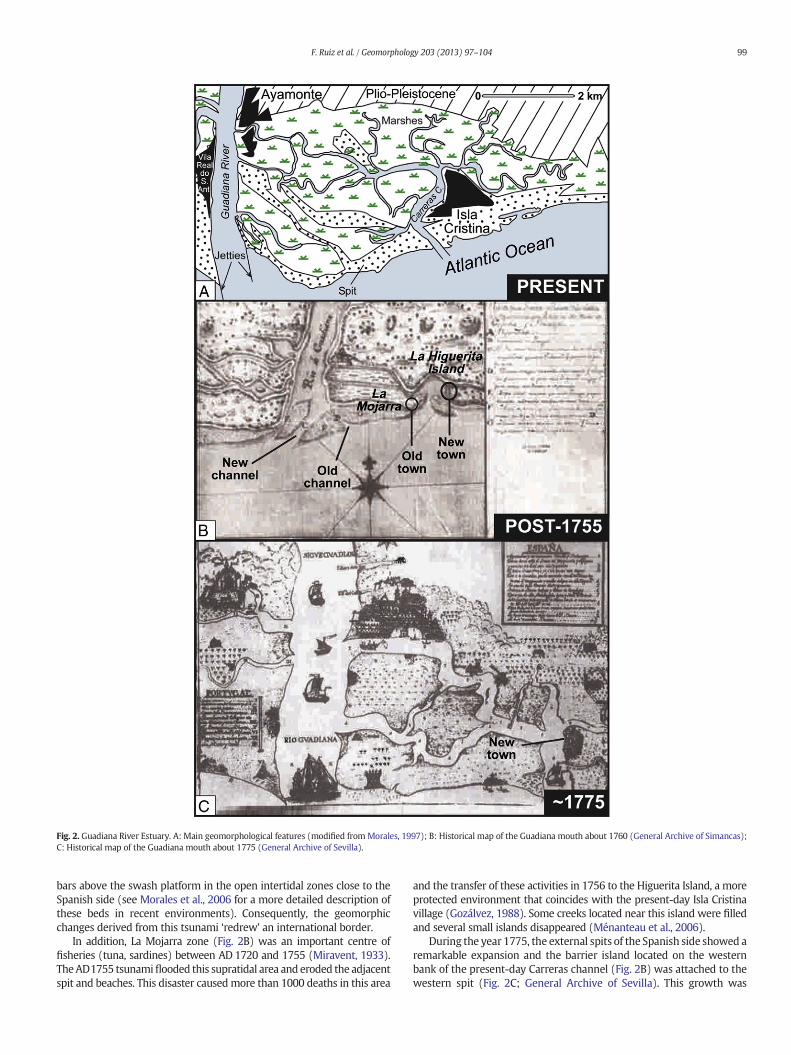
Fig. 2. Guadiana River Estuary. A: Main geomorphological features (modified from Morales, 1997); B: Historical map of the Guadiana mouth about 1760 (General Archive of Simancas);C: Historical map of the Guadiana mouth about 1775 (General Archive of Sevilla).
99F. Ruiz et al. / Geomorphology 203 (2013) 97–104
bars above the swash platform in the open intertidal zones close to theSpanish side (see Morales et al., 2006 for a more detailed description ofthese beds in recent environments). Consequently, the geomorphicchanges derived from this tsunami ‘redrew’ an international border.
In addition, La Mojarra zone (Fig. 2B) was an important centre offisheries (tuna, sardines) between AD 1720 and 1755 (Miravent, 1933).TheAD1755 tsunamiflooded this supratidal area and eroded the adjacentspit and beaches. This disaster causedmore than 1000 deaths in this area
and the transfer of these activities in 1756 to the Higuerita Island, a moreprotected environment that coincides with the present-day Isla Cristinavillage (Gozálvez, 1988). Some creeks located near this island were filledand several small islands disappeared (Ménanteau et al., 2006).
During the year 1775, the external spits of the Spanish side showed aremarkable expansion and the barrier island located on the westernbank of the present-day Carreras channel (Fig. 2B) was attached to thewestern spit (Fig. 2C; General Archive of Sevilla). This growth was

Fig. 3. Tinto–Odiel River Estuary. A: Main geomorphological features. Circles indicate geographical references for Fig. 3B–C–D. VH-5, VT-8, VR-18: examples of sediment cores withtsunamigenic layers (extracted from Morales et al., 2008); B–C–D: geomorphological evolution of Punta Umbría spit during the last 6000 years. Modified from Rodríguez-Vidal (1987).
100 F. Ruiz et al. / Geomorphology 203 (2013) 97–104
clearly controlled by the W–E littoral drift currents and the Guadianasediment supplies, not regulated by dams at that time.
4.2. Tinto–Odiel Estuary
The Tinto–Odiel Estuary is a 25 km long incised valley underlain byPlio–Pleistocene marine and fluvial sediments. A cross-section of theouter zone shows two main (Punta Umbría and Punta Arenillas)sandy spits (Fig. 3A) separated by the Saltés Island, a salt-marsh
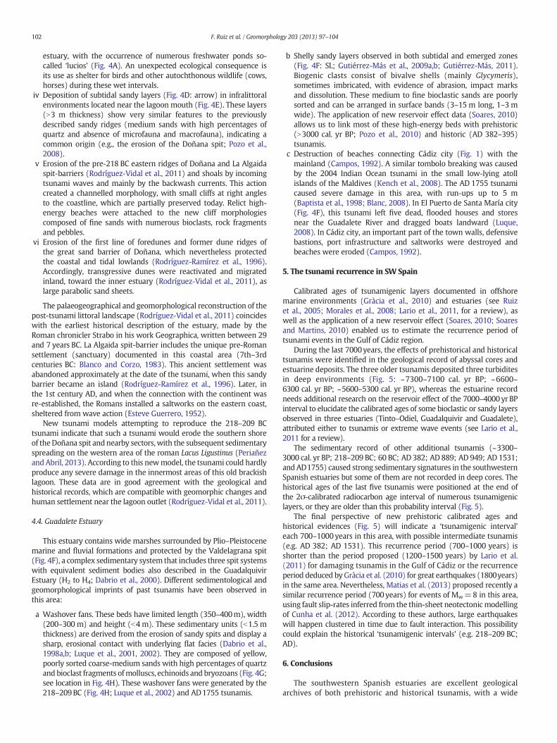
Fig. 4. Guadalquivir River Estuary (A–E) and Guadalete River Estuary (F–H). A: Main geomorphcoreD, including the calibrated ages of two tsunamigenic layers (modified fromRuiz et al., 2004Vidal et al., 2011). D: Sedimentological features of long sediment core, including two calibratesthe Guadalquivir mouth (218–209 BC) (modified from Rodríguez-Vidal et al., 2011). F: Main geemerged trenches or subtidal coreswith tsunamigenic, shelly layers (data fromGutiérrez-Más ewith a draw top limited by sedimentological and palaeontological features (modified from Luqumodified from Luque et al., 2002), with location of cores. Panels B, D, F, G and H share their leg
sediment body comprising old spits. This central island delineates thedeeper Padre Santo channel, which is the main passage to the Huelvaharbour, and the narrower Punta Umbría channel.
In this estuary, the maximum of the Holocene transgression(7000–6500 yr BP; Zazo et al., 1994) marked the beginning of keygeomorphological features (e.g. Punta Umbría spit) that controlledits subsequent evolution. In an early stage (6000–2500 yr BP), thePunta Umbría spit emerged and prograded southeastward with theprogressive addition of attached beach berms. In this phase, several
ological characteristics of the river mouth. B: Sedimentological features of short sediment). C: Interpretative cross-section of this area during Roman time (modified fromRodríguez-ages (modified from Rodríguez-Vidal et al., 2011). E: Palaeogeographical reconstruction ofomorphological features of the Guadalete Estuary (modified from Luque et al., 2002); SL:t al., 2009b; Gutiérrez-Más, 2011). G:washover fans deposited by the 218–209BC tsunami,e et al., 2002). H: Palaeogeographical reconstruction of theGuadalete Estuary (218–209BC;ends.
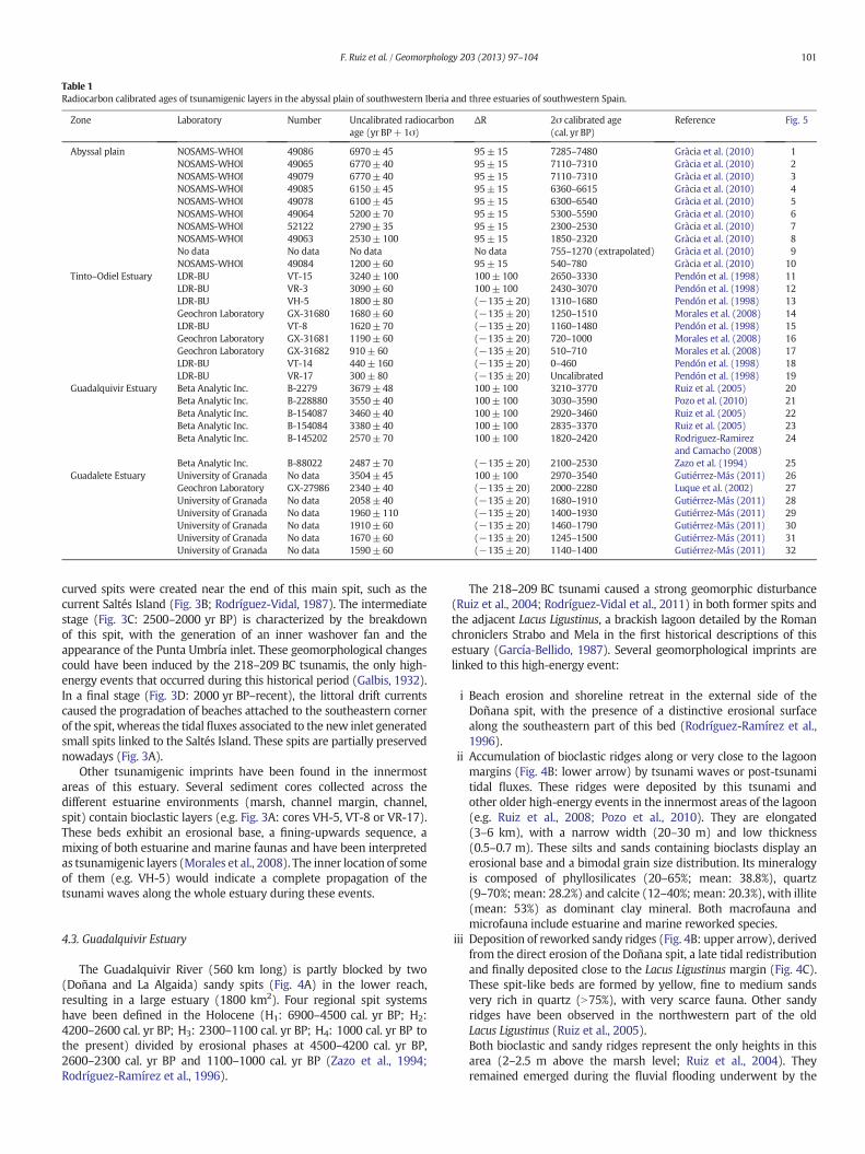
Table 1Radiocarbon calibrated ages of tsunamigenic layers in the abyssal plain of southwestern Iberia and three estuaries of southwestern Spain.
Zone Laboratory Number Uncalibrated radiocarbonage (yr BP+1σ)
ΔR 2σ calibrated age(cal. yr BP)
Reference Fig. 5
Abyssal plain NOSAMS-WHOI 49086 6970±45 95±15 7285–7480 Gràcia et al. (2010) 1NOSAMS-WHOI 49065 6770±40 95±15 7110–7310 Gràcia et al. (2010) 2NOSAMS-WHOI 49079 6770±40 95±15 7110–7310 Gràcia et al. (2010) 3NOSAMS-WHOI 49085 6150±45 95±15 6360–6615 Gràcia et al. (2010) 4NOSAMS-WHOI 49078 6100±45 95±15 6300–6540 Gràcia et al. (2010) 5NOSAMS-WHOI 49064 5200±70 95±15 5300–5590 Gràcia et al. (2010) 6NOSAMS-WHOI 52122 2790±35 95±15 2300–2530 Gràcia et al. (2010) 7NOSAMS-WHOI 49063 2530±100 95±15 1850–2320 Gràcia et al. (2010) 8No data No data No data No data 755–1270 (extrapolated) Gràcia et al. (2010) 9NOSAMS-WHOI 49084 1200±60 95±15 540–780 Gràcia et al. (2010) 10
Tinto–Odiel Estuary LDR-BU VT-15 3240±100 100± 100 2650–3330 Pendón et al. (1998) 11LDR-BU VR-3 3090±60 100± 100 2430–3070 Pendón et al. (1998) 12LDR-BU VH-5 1800±80 (−135±20) 1310–1680 Pendón et al. (1998) 13Geochron Laboratory GX-31680 1680±60 (−135±20) 1250–1510 Morales et al. (2008) 14LDR-BU VT-8 1620±70 (−135±20) 1160–1480 Pendón et al. (1998) 15Geochron Laboratory GX-31681 1190±60 (−135±20) 720–1000 Morales et al. (2008) 16Geochron Laboratory GX-31682 910± 60 (−135±20) 510–710 Morales et al. (2008) 17LDR-BU VT-14 440± 160 (−135±20) 0–460 Pendón et al. (1998) 18LDR-BU VR-17 300± 80 (−135±20) Uncalibrated Pendón et al. (1998) 19
Guadalquivir Estuary Beta Analytic Inc. B-2279 3679±48 100± 100 3210–3770 Ruiz et al. (2005) 20Beta Analytic Inc. B-228880 3550±40 100± 100 3030–3590 Pozo et al. (2010) 21Beta Analytic Inc. B-154087 3460±40 100± 100 2920–3460 Ruiz et al. (2005) 22Beta Analytic Inc. B-154084 3380±40 100± 100 2835–3370 Ruiz et al. (2005) 23Beta Analytic Inc. B-145202 2570±70 100± 100 1820–2420 Rodriguez-Ramirez
and Camacho (2008)24
Beta Analytic Inc. B-88022 2487±70 (−135±20) 2100–2530 Zazo et al. (1994) 25Guadalete Estuary University of Granada No data 3504±45 100± 100 2970–3540 Gutiérrez-Más (2011) 26
Geochron Laboratory GX-27986 2340±40 (−135±20) 2000–2280 Luque et al. (2002) 27University of Granada No data 2058±40 (−135±20) 1680–1910 Gutiérrez-Más (2011) 28University of Granada No data 1960±110 (−135±20) 1400–1930 Gutiérrez-Más (2011) 29University of Granada No data 1910±60 (−135±20) 1460–1790 Gutiérrez-Más (2011) 30University of Granada No data 1670±60 (−135±20) 1245–1500 Gutiérrez-Más (2011) 31University of Granada No data 1590±60 (−135±20) 1140–1400 Gutiérrez-Más (2011) 32
101F. Ruiz et al. / Geomorphology 203 (2013) 97–104
curved spits were created near the end of this main spit, such as thecurrent Saltés Island (Fig. 3B; Rodríguez-Vidal, 1987). The intermediatestage (Fig. 3C: 2500–2000 yr BP) is characterized by the breakdownof this spit, with the generation of an inner washover fan and theappearance of the Punta Umbría inlet. These geomorphological changescould have been induced by the 218–209 BC tsunamis, the only high-energy events that occurred during this historical period (Galbis, 1932).In a final stage (Fig. 3D: 2000 yr BP–recent), the littoral drift currentscaused the progradation of beaches attached to the southeastern cornerof the spit, whereas the tidal fluxes associated to the new inlet generatedsmall spits linked to the Saltés Island. These spits are partially preservednowadays (Fig. 3A).
Other tsunamigenic imprints have been found in the innermostareas of this estuary. Several sediment cores collected across thedifferent estuarine environments (marsh, channel margin, channel,spit) contain bioclastic layers (e.g. Fig. 3A: cores VH-5, VT-8 or VR-17).These beds exhibit an erosional base, a fining-upwards sequence, amixing of both estuarine and marine faunas and have been interpretedas tsunamigenic layers (Morales et al., 2008). The inner location of someof them (e.g. VH-5) would indicate a complete propagation of thetsunami waves along the whole estuary during these events.
4.3. Guadalquivir Estuary
The Guadalquivir River (560 km long) is partly blocked by two(Doñana and La Algaida) sandy spits (Fig. 4A) in the lower reach,resulting in a large estuary (1800 km2). Four regional spit systemshave been defined in the Holocene (H1: 6900–4500 cal. yr BP; H2:4200–2600 cal. yr BP; H3: 2300–1100 cal. yr BP; H4: 1000 cal. yr BP tothe present) divided by erosional phases at 4500–4200 cal. yr BP,2600–2300 cal. yr BP and 1100–1000 cal. yr BP (Zazo et al., 1994;Rodríguez-Ramírez et al., 1996).
The 218–209 BC tsunami caused a strong geomorphic disturbance(Ruiz et al., 2004; Rodríguez-Vidal et al., 2011) in both former spits andthe adjacent Lacus Ligustinus, a brackish lagoon detailed by the Romanchroniclers Strabo and Mela in the first historical descriptions of thisestuary (García-Bellido, 1987). Several geomorphological imprints arelinked to this high-energy event:
i Beach erosion and shoreline retreat in the external side of theDoñana spit, with the presence of a distinctive erosional surfacealong the southeastern part of this bed (Rodríguez-Ramírez et al.,1996).
ii Accumulation of bioclastic ridges along or very close to the lagoonmargins (Fig. 4B: lower arrow) by tsunami waves or post-tsunamitidal fluxes. These ridges were deposited by this tsunami andother older high-energy events in the innermost areas of the lagoon(e.g. Ruiz et al., 2008; Pozo et al., 2010). They are elongated(3–6 km), with a narrow width (20–30 m) and low thickness(0.5–0.7 m). These silts and sands containing bioclasts display anerosional base and a bimodal grain size distribution. Its mineralogyis composed of phyllosilicates (20–65%; mean: 38.8%), quartz(9–70%; mean: 28.2%) and calcite (12–40%; mean: 20.3%), with illite(mean: 53%) as dominant clay mineral. Both macrofauna andmicrofauna include estuarine and marine reworked species.
iii Deposition of reworked sandy ridges (Fig. 4B: upper arrow), derivedfrom the direct erosion of the Doñana spit, a late tidal redistributionand finally deposited close to the Lacus Ligustinus margin (Fig. 4C).These spit-like beds are formed by yellow, fine to medium sandsvery rich in quartz (N75%), with very scarce fauna. Other sandyridges have been observed in the northwestern part of the oldLacus Ligustinus (Ruiz et al., 2005).Both bioclastic and sandy ridges represent the only heights in thisarea (2–2.5 m above the marsh level; Ruiz et al., 2004). Theyremained emerged during the fluvial flooding underwent by the
102 F. Ruiz et al. / Geomorphology 203 (2013) 97–104
estuary, with the occurrence of numerous freshwater ponds so-called ‘lucios’ (Fig. 4A). An unexpected ecological consequence isits use as shelter for birds and other autochthonous wildlife (cows,horses) during these wet intervals.
iv Deposition of subtidal sandy layers (Fig. 4D: arrow) in infralittoralenvironments located near the lagoon mouth (Fig. 4E). These layers(N3 m thickness) show very similar features to the previouslydescribed sandy ridges (medium sands with high percentages ofquartz and absence of microfauna and macrofauna), indicating acommon origin (e.g., the erosion of the Doñana spit; Pozo et al.,2008).
v Erosion of the pre-218 BC eastern ridges of Doñana and La Algaidaspit-barriers (Rodríguez-Vidal et al., 2011) and shoals by incomingtsunami waves and mainly by the backwash currents. This actioncreated a channelled morphology, with small cliffs at right anglesto the coastline, which are partially preserved today. Relict high-energy beaches were attached to the new cliff morphologiescomposed of fine sands with numerous bioclasts, rock fragmentsand pebbles.
vi Erosion of the first line of foredunes and former dune ridges ofthe great sand barrier of Doñana, which nevertheless protectedthe coastal and tidal lowlands (Rodríguez-Ramírez et al., 1996).Accordingly, transgressive dunes were reactivated and migratedinland, toward the inner estuary (Rodríguez-Vidal et al., 2011), aslarge parabolic sand sheets.
The palaeogeographical and geomorphological reconstruction of thepost-tsunami littoral landscape (Rodríguez-Vidal et al., 2011) coincideswith the earliest historical description of the estuary, made by theRoman chronicler Strabo in his work Geographica, written between 29and 7 years BC. La Algaida spit-barrier includes the unique pre-Romansettlement (sanctuary) documented in this coastal area (7th–3rdcenturies BC: Blanco and Corzo, 1983). This ancient settlement wasabandoned approximately at the date of the tsunami, when this sandybarrier became an island (Rodríguez-Ramírez et al., 1996). Later, inthe 1st century AD, and when the connection with the continent wasre-established, the Romans installed a saltworks on the eastern coast,sheltered from wave action (Esteve Guerrero, 1952).
New tsunami models attempting to reproduce the 218–209 BCtsunami indicate that such a tsunami would erode the southern shoreof theDoñana spit and nearby sectors, with the subsequent sedimentaryspreading on the western area of the roman Lacus Ligustinus (Periañezand Abril, 2013). According to this newmodel, the tsunami could hardlyproduce any severe damage in the innermost areas of this old brackishlagoon. These data are in good agreement with the geological andhistorical records, which are compatible with geomorphic changes andhuman settlement near the lagoon outlet (Rodríguez-Vidal et al., 2011).
4.4. Guadalete Estuary
This estuary contains wide marshes surrounded by Plio–Pleistocenemarine and fluvial formations and protected by the Valdelagrana spit(Fig. 4F), a complex sedimentary system that includes three spit systemswith equivalent sediment bodies also described in the GuadalquivirEstuary (H2 to H4; Dabrio et al., 2000). Different sedimentological andgeomorphological imprints of past tsunamis have been observed inthis area:
a Washover fans. These beds have limited length (350–400m), width(200–300 m) and height (b4 m). These sedimentary units (b1.5 mthickness) are derived from the erosion of sandy spits and display asharp, erosional contact with underlying flat facies (Dabrio et al.,1998a,b; Luque et al., 2001, 2002). They are composed of yellow,poorly sorted coarse-medium sands with high percentages of quartzand bioclast fragments ofmolluscs, echinoids and bryozoans (Fig. 4G;see location in Fig. 4H). These washover fans were generated by the218–209BC (Fig. 4H; Luque et al., 2002) and AD1755 tsunamis.
b Shelly sandy layers observed in both subtidal and emerged zones(Fig. 4F: SL; Gutiérrez-Más et al., 2009a,b; Gutiérrez-Más, 2011).Biogenic clasts consist of bivalve shells (mainly Glycymeris),sometimes imbricated, with evidence of abrasion, impact marksand dissolution. These medium to fine bioclastic sands are poorlysorted and can be arranged in surface bands (3–15 m long, 1–3 mwide). The application of new reservoir effect data (Soares, 2010)allows us to link most of these high-energy beds with prehistoric(N3000 cal. yr BP; Pozo et al., 2010) and historic (AD 382–395)tsunamis.
c Destruction of beaches connecting Cádiz city (Fig. 1) with themainland (Campos, 1992). A similar tombolo breaking was causedby the 2004 Indian Ocean tsunami in the small low-lying atollislands of the Maldives (Kench et al., 2008). The AD 1755 tsunamicaused severe damage in this area, with run-ups up to 5 m(Baptista et al., 1998; Blanc, 2008). In El Puerto de Santa María city(Fig. 4F), this tsunami left five dead, flooded houses and storesnear the Guadalete River and dragged boats landward (Luque,2008). In Cádiz city, an important part of the town walls, defensivebastions, port infrastructure and saltworks were destroyed andbeaches were eroded (Campos, 1992).
5. The tsunami recurrence in SW Spain
Calibrated ages of tsunamigenic layers documented in offshoremarine environments (Gràcia et al., 2010) and estuaries (see Ruizet al., 2005; Morales et al., 2008; Lario et al., 2011, for a review), aswell as the application of a new reservoir effect (Soares, 2010; Soaresand Martins, 2010) enabled us to estimate the recurrence period oftsunami events in the Gulf of Cádiz region.
During the last 7000years, the effects of prehistorical and historicaltsunamis were identified in the geological record of abyssal cores andestuarine deposits. The three older tsunamis deposited three turbiditesin deep environments (Fig. 5: ~7300–7100 cal. yr BP; ~6600–6300 cal. yr BP; ~5600–5300 cal. yr BP), whereas the estuarine recordneeds additional research on the reservoir effect of the 7000–4000yr BPinterval to elucidate the calibrated ages of some bioclastic or sandy layersobserved in three estuaries (Tinto–Odiel, Guadalquivir and Guadalete),attributed either to tsunamis or extreme wave events (see Lario et al.,2011 for a review).
The sedimentary record of other additional tsunamis (~3300–3000 cal. yr BP; 218–209 BC; 60 BC; AD 382; AD 889; AD 949; AD 1531;and AD1755) caused strong sedimentary signatures in the southwesternSpanish estuaries but some of them are not recorded in deep cores. Thehistorical ages of the last five tsunamis were positioned at the end ofthe 2σ-calibrated radiocarbon age interval of numerous tsunamigeniclayers, or they are older than this probability interval (Fig. 5).
The final perspective of new prehistoric calibrated ages andhistorical evidences (Fig. 5) will indicate a ‘tsunamigenic interval’each 700–1000years in this area, with possible intermediate tsunamis(e.g. AD 382; AD 1531). This recurrence period (700–1000 years) isshorter than the period proposed (1200–1500 years) by Lario et al.(2011) for damaging tsunamis in the Gulf of Cádiz or the recurrenceperiod deduced by Gràcia et al. (2010) for great earthquakes (1800years)in the same area. Nevertheless, Matias et al. (2013) proposed recently asimilar recurrence period (700years) for events of Mw=8 in this area,using fault slip-rates inferred from the thin-sheet neotectonicmodellingof Cunha et al. (2012). According to these authors, large earthquakeswill happen clustered in time due to fault interaction. This possibilitycould explain the historical ‘tsunamigenic intervals’ (e.g. 218–209 BC;AD).
6. Conclusions
The southwestern Spanish estuaries are excellent geologicalarchives of both prehistoric and historical tsunamis, with a wide

Fig. 5. Calibrated ages of tsunamigenic layers in deep cores and three estuaries of southwestern Spain. Original data from Luque et al. (2002), Ruiz et al. (2004, 2005, 2008), Morales et al.(2008), Gutiérrez-Más et al. (2009a,b), Pozo et al. (2010), Gràcia et al. (2010), Rodríguez-Vidal et al. (2011), Gutiérrez-Más (2011) and Lario et al. (2011).
103F. Ruiz et al. / Geomorphology 203 (2013) 97–104
set of sedimentological and geomorphological imprints. The mostfrequent features are beach erosion with shoreline retreat, breakingor overwash of sandy spits and deposition of bioclastic layers.
During the last 4000years, two historical tsunamis (218–209BC andAD1755) are revealed as extremely violent eventswhich causedmost ofthese geomorphic imprints. The geomorphological record of othertsunamis (3300–3000cal. yr BP, AD382, AD1531) is more restricted.
The 218–209 BC and AD 1755 tsunamis caused substantial changesin the coastal settlements and their adjacent landscapes, with thecreation of new waterways and/or the relocation of fishery activities.They clearly conditioned the further geographical development ofthese areas. In addition, the AD 1755 tsunami was accompanied byhigh mortality and probably by important injury among the exposedpopulation.
The application of a newmarine reservoir effect and additional dataderived from new tectonic models suggest a recurrence period of700–1000years for a ‘tsunamigenic interval’ along this Atlantic shore.
Acknowledgements
This researchwas funded by the Spanish—FEDER Projects CTM2006-06722/MAR, CGL2006-01412/BTE, CGL2010-15810/BTE and CGL2012-30875, an Excellence Project of the Andalucia Board (SEJ-4770) fundedby EU, a Project funded by the Fundaçao para a Ciência e a Tecnologia(PTDC/CTE-GIX/110205/2009) and three Research Groups of theAndalucia Board (RNM-238, RNM-293, and RNM-349). We thankreviewers and guest-editors for helpful comments. This work is acontribution to the IGCPs 526 (risks, resources, and record of thepast on the continental shelf), 567 (Earthquake Archaeology andPalaeoseismology), and 588 (preparing for coastal change).
References
Baptista, M.A., Heitor, S., Miranda, J.M., Mendes Victor, L., 1998. The 1755 Lisbon tsunami:evaluation of tsunami parameters. J. Geodyn. 25, 143–157.
Blanc, P.L., 2008. The tsunami in Cádiz on 1 November 1755: a critical analysis of reportsby Antonio de Ulloa and by Louis Godin. Compt. Rendus Geosci. 340, 251–261.
Blanco, A., Corzo, R., 1983. Monte Algaida. Un santuario púnico en la desembocadura delGuadalquivir. Historia 16 (87), 122–128.
Campos, M.L., 1991. Tsunami hazard on the Spanish coasts of the Iberian peninsula. Sci.Tsunami Hazards 9, 83–90.
Campos, M.L., 1992. El riesgo de tsunamis en España. Análisis y valoración geográfica, vol.9. Monografías Instituto Geográfico Nacional, Madrid (204 pp.).
Choowong, M., Phantuwongraj, S., Charoentitirar, T., Chutakositkanon, V., Yumuand, S.,Charusiri, P., 2009. Beach recovery after 2004 Indian Ocean tsunami from Phang-nga,Thailand. Geomorphology 104, 134–142.
Cunha, T.A., Matias, L.M., Terrinha, P., Negredo, A., Rosas, F., Fernandes, R.M.S., Pinheiro,L.M., 2012. Neotectonics of the SW Iberia margin, Gulf of Cadiz and Alboran Sea: areassessment including recent structural, seismic and geodetic data. Geophys. J. Int.188, 850–872.
Cuven, S., Paris, R., Falvard, S., Miot-Noirault, E., Benbakkar, M., Schneider, J.-L., Billy, I.,2013. High-resolution analysis of a tsunami deposit: case-study from the 1755Lisbon tsunami in southwestern Spain. Mar. Geol. 337, 98–111.
Dabrio, C.J., Zazo, C., Lario, J., Goy, J.L., Sierro, F.J., Borja, F., González, J.A., Flores, J.A., 1998a.Holocene incised-valley fills and coastal evolution in the Gulf of Cádiz (southernSpain). Mediterr. Black Sea Subcommission Newsl. 20, 45–48.
Dabrio, C.J., Goy, J.L., Zazo, C., 1998b. The record of the tsunami produced by the 1755 Lisbonearthquake in Valdelagrana spit (Gulf of Cádiz, southern Spain). Geogaceta 23, 31–34.
Dabrio, C.J., Zazo, C., Goy, J.L., Sierro, F.J., Borja, F., Lario, J., González, J.A., Flores, J.A., 2000.Depositional history of estuarine infill during the last post-glacial transgression (Gulfof Cadiz, southern Spain). Mar. Geol. 162, 381–404.
Esteve Guerrero, M., 1952. Sanlúcar de Barrameda (Cádiz): fábrica de salazón romana enLa Algaida. Not. Arqueológico Hispánico 1–3, 126–133.
Fagherazzi, S., Du, X., 2008. Tsunamigenic incisions produced by the December 2004earthquake along the coasts of Thailand, Indonesia and Sri Lanka. Geomorphology99, 120–129.
Galbis, R.J., 1932. Catálogo sísmico de la zona comprendida entre los meridianos 58° E y20° W de Greenwich y los paralelos 45° y 25° N. Dirección General del InstitutoGeográfico, Catastral y de Estadística, Madrid.
García-Bellido, A., 1987. La España del siglo primero de nuestra era (según P. Mela y C.Plinio). Colección Austral.Espasa Calpe, Madrid.
General Archive de Sevilla, 1775. Plano de la desembocadura del río Guadiana.General Archive of Simancas, 1764. Plano de la barra y puerto de la ciudad de
Ayamonte que divide los dos Reinos de España y Portugal.Goff, J., Pearce, S., Nichol, S.L., Ghabué-Goff, C., Horrocks, M., Strotz, L., 2010. Multi-proxy
records of regionally-sourced tsunamis, New Zealand. Geomorphology 118, 369–382.Goto, K., Takahashi, J., Oie, T., Imamuera, F., 2011. Remarkable bathymetric change in the
nearshore zone by the 2004 Indian Ocean tsunami: Kirinda Harbor, Sri Lanka.Geomorphology 127, 107–116.
Gozálvez, J.L., 1988. Los orígenes de Isla Cristina. El impulso pesquero.Ilmo, Ayuntamientode Isla Cristina.
Gozálvez, J.L., 2002. Un ensayo de reconstrucción de la línea de costa histórica: Ayamonte,siglos XVII–XX. J. Hist. Ayamonte VI, 51–82.
Gràcia, E., Vizcaino, A., Escutia, C., Asioli, A., Rodés, A., Pallàs, R., García-Orellana, J.,Lebreiro, S., Goldfinger, C., 2010. Holocene earthquake record offshore Portugal(SW Iberia): testing turbidite paleoseismology in a slow-convergence margin. Quat.Sci. Rev. 29, 1156–1172.
Gutiérrez-Más, J.M., 2011. Glycymeris shell accumulations as indicators of recent sea-levelchanges and high-energy events in Cádiz Bay (SW Spain). Estuar. Coast. Shelf Sci. 92,546–554.
Gutiérrez-Más, J.M., López-Arroyo, J., Morales, J.A., 2009a. Recent marine lithofacies inCádiz Bay (SW Spain): sequences, processes and control factors. Sediment. Geol.218, 31–47.
Gutiérrez-Más, J.M., Juan, C., Morales, J.A., 2009b. Evidence of high-energy events in shellylayers interbedded in coastal Holocene sands in Cádiz Bay (south-west Spain). EarthSurf. Process. Landf. 34, 810–823.

104 F. Ruiz et al. / Geomorphology 203 (2013) 97–104
Hindson, R., Andrade, C., Parish, R., 1999. A microfaunal and sedimentary record ofenvironmental change within the late Holocene sediments of Boca do Rio (Algarve,Portugal). Geol. Mijnb. 77, 311–321.
Kench, P.S., Nichol, S.L., Smithers, S.G., McLean, R.F., Brander, R.W., 2008. Tsunami asagents of geomorphic change in mid-ocean reef islands. Geomorphology 95,361–383.
Lario, J., Zazo, C., Goy, J.L., Silva, P.G., Bardají, T., Cabero, A., Dabrio, C.J., 2011. Holocenepalaeotsunami catalogue of SW Iberia. Quat. Int. 242, 196–209.
Liew, S.C., Gupta, A., Wong, P.P., Kwoh, L.K., 2010. Recovery from a large tsunami mappedover time: the Aceh coast, Sumatra. Geomorphology 114, 520–529.
Lima, V.V., Miranda, J.M., Baptista, M.A., Catalao, J., González, M., Otero, L., Olabarrieta, M.,Álvarez-Gómez, J.A., Carreño, E., 2010. Impact of a 1755-like tsunami in Huelva, Spain.Nat. Hazards Earth Syst. Sci. 10, 139–148.
Luque, L., 2008. El impacto de eventos catastróficos costeros en el litoral del Golfo deCádiz. Rev. Atlántica Mediterr. Prehist. Arqueol. Soc. 10, 131–153.
Luque, L., Lario, J., Zazo, C., Goy, J.L., Dabrio, C.J., Silva, P.G., 2001. Tsunami deposits aspalaeoseismic indicators: examples from the Spanish coast. Acta Geol. Hisp. 3–4,197–211.
Luque, L., Lario, J., Civis, J., Silva, P.G., Zazo, C., Goy, J.L., Dabrio, C.J., 2002. Sedimentaryrecord of a tsunami during Roman times, Bay of Cádiz. J. Quat. Sci. 17, 623–631.
Mascarenhas, A., 2006. Extreme events, intrinsic landforms and humankind: post-tsunami scenario along Nagore–Velankanni coast, Tamil Nadu, India. Curr. Sci.90–99, 1195–1201.
Matias, L.M., Cunha, T., Annunziato, A., Baptista, M.A., Carrilho, F., 2013. Tsunamigenicearthquakes in the Gulf of Cádiz: fault model and recurrence. Nat. Hazards EarthSyst. Sci. 13, 1–13.
Ménanteau, L., Chadenas, C., Choblet, C., 2006. Les marais du Bas-Guadiana (Algarve,Andalousie): empreise, déprise et reprise humaines. Aestuaria 9, 309–331.
Miravent, J., 1933. Memoria sobre la fundación y progresos de la Real Isla de la Higuerita(Reprinted by Artes Gráficas M. Vázquez, Isla Cristina, Spain).
Monecke, K., Finger, W., Klarer, D., Kongko, W., McAdoo, B.G., Moore, A.L., Sudrajat, S.U.,2008. A 1000-year sediment record of tsunami recurrence in northern Sumatra.Nature 455, 1232–1234.
Morales, J.A., 1997. Evolution and facies architecture of the mesotidal Guadiana Riverdelta (S.W. Spain–Portugal). Mar. Geol. 138, 127–148.
Morales, J.A., Delgado, I., Gutiérrez-Mas, J.M., 2006. Sedimentary characterization of bedtypes along the Guadiana estuary (SW Europe) before the construction of theAlqueva dam. Estuar. Coast. Shelf Sci. 70, 117–131.
Morales, J.A., Borrego, J., San Miguel, E.G., López-González, N., Carro, B., 2008. Sedimentaryrecord of recent tsunamis in the Huelva estuary (southwestern Spain). Quat. Sci. Rev.27, 734–746.
Omira, R., Baptista, M.A., Miranda, J.M., Toto, E., Catita, C., Catalao, J., 2010. Tsunamivulnerability assessment of Casablanca—Morocco using numerical modelling andGIS tools. Nat. Hazards 54, 75–95.
Paris, R., Wassmer, P., Sartohadi, J., Lavigne, F., Barthomeuf, B., Desgages, E., Grancher, D.,Baumert, P., Vautier, F., Brunstein, D., Gomez, C., 2009. Tsunamis as geomorphic crisis:lessons from the December 26, 2004 tsunami in Lhok Nga, west Banda Aceh(Sumatra, Indonesia). Geomorphology 104, 59–72.
Pendón, J.G., Morales, J.A., Borrego, J., Jiménez, 1., López, M., 1998. Evolution of estuarinefacies in a tidal channel environment SW Spain: evidence for a change from tide-to wave-domination. Mar. Geol. 147, 43–62.
Periañez, R., Abril, J.M., 2013. Modeling tsunami propagation in the Iberia–Africa plateboundary: historical events, regional exposure and the case-study of the formerGulf of Tartessos. J. Mar. Syst. 111–112, 223–234.
Pozo, M., Carretero, M.I., Ruiz, F., Rodríguez Vidal, J., Cáceres, L.M., Abad, M., 2008.Caracterización mineralógica de facies sedimentarias de edad Pleistoceno superior–Holoceno en el Parque Nacional de Doñana (Huelva). Implicaciones paleoambientales.Geotemas 10, 953–956.
Pozo, M., Ruiz, F., Carretero, M.I., Rodríguez Vidal, J., Cáceres, L.M., Abad, M., González-Regalado, M.L., 2010.Mineralogical assemblages, geochemistry and fossil associationsof Pleistocene–Holocene complex siliciclastic deposits from the southwesternDoñana National Park (SW Spain): a palaeoenvironmental approach. Sediment.Geol. 225, 1–18.
Rodriguez-Ramirez, A., Camacho, C.M., 2008. Formation of chenier plain of the Doñanamarshland (SW Spain): observations and geomorphic model. Mar. Geol. 254,187–196.
Rodríguez-Ramírez, A., Rodríguez-Vidal, J., Cáceres, L.M., Clemente, L., Belluomini, G.,Manfra, L., Improta, S., de Andrés, J.R., 1996. Recent coastal evolution of the DoñanaNational Park (SW Spain). Quat. Sci. Rev. 15, 803–809.
Rodríguez-Vidal, J., 1987. Modelo de evolución geomorfológica de la flecha litoral dePunta Umbría, Huelva, España. Cuaternario y Geomorfología 1, 247–256.
Rodríguez-Vidal, J., Ruiz, F., Cáceres, L.M., Abad, M., González-Regalado, M.L., Pozo, M.,Carretero, M.I., Monge, A.M., Gómez, F., 2011. Geomarkers of the 218–209BC Atlantictsunami in the Roman Lacus Ligustinus (SW Spain): a palaeogeographical approach.Quat. Int. 242, 201–212.
Ruiz, F., Rodríguez Ramírez, A., Cáceres, L.M., Rodríguez-Vidal, J., Carretero, M.L.,Clemente, L., Muñoz, J.M., Yáñez, C., Abad, M., 2004. Late Holocene evolution ofthe southwestern Doñana National Park (Guadalquivir Estuary, SW Spain): amultivariate approach. Palaeogeogr. Palaeoclimatol. Palaeoecol. 204, 47–64.
Ruiz, F., Rodríguez Ramírez, A., Cáceres, L.M., Rodríguez Vidal, J., Carretero, M.I., Abad, M.,Olías, M., Pozo, M., 2005. Evidence of high-energy events in the geological record:mid-Holocene evolution of the southwestern Doñana National Park (SW Spain).Palaeogeogr. Palaeoclimatol. Palaeoecol. 229, 212–229.
Ruiz, F., Abad, M., Rodríguez-Vidal, J., Cáceres, L.M., González-Regalado, M.L., Carretero,M.I., Pozo, M., Gómez Toscano, F., 2008. The geological record of the oldest historicaltsunamis in southwestern Spain. Riv. Ital. Paleontol. Stratigr. 114, 147–156.
Salvany, J.M., Cruz Larrasoaña, J., Mediavilla, C., Rebollo, A., 2011. Chronology and tectono-sedimentary evolution of the Upper Pliocene to Quaternary deposits of the lowerGuadalquivir foreland basin, SW Spain. Sediment. Geol. 241, 22–39.
Scheffers, A., Kelletat, D., 2005. Tsunami relics in the coastal landscape west of Lisbon,Portugal. Sci. Tsunami Hazards 23, 3–16.
Siwar, C., Ibrahim, M.Z., Harizan, S.T.M., Kamaruddin, R., 2006. Impact of tsunami onfishing, aquaculture and coastal communities in Malaysia. Proceedings PersidanganAntarabangsa Pembangunan Aceh, UKM Bangi, Malaysia, pp. 41–52.
Soares, A.A.M., 2010. Comment of ‘Formation of chenier plain of the Doñana marshland(SW Spain): observations and geomorphic model’ by A. Rodríguez Ramírez andC.M. Yáñez Camacho [Marine Geology 254, 187–196]. Mar. Geol. 275, 287–289.
Soares, A.M.M., Martins, J.M.M., 2010. Radiocarbon dating of marine samples from Gulf ofCadiz: the reservoir effect. Quat. Int. 221, 9–12.
Solares, J.M.M., Arroyo, A.L., 2004. The great historical 1755 earthquake. Effects anddamage in Spain. J. Seismol. 8, 275–294.
Szczucinski, W., Chaimanee, N., Niedzielski, P., Rachlewicz, G., Saisuttichai, D., Tepsuwam,T., Lorenc, S., Siepak, J., 2006. Environmental and geological impacts of the 26December 2004 tsunami in coastal zone of Thailand—overview of short and long-term effects. Pol. J. Environ. Stud. 15, 793–810.
Zazo, C., Goy, J.L., Somoza, L., Dabrio, C.J., Belluomini, G., Improta, S., Lario, J., Bardaji, T.,Silva, P.G., 1994. Holocene sequence of sea-level fluctuations in relation to climatictrends in the Atlantic–Mediterranean linkage coast. J. Coast. Res. 10, 933–945.