Embed Size (px)
Citation preview
80� E
70� E
90� E
10� N10� N
20� N
Kanchenjunga28,208 ft.(8,598 m)
H
IM
AL
A Y A S
EASTERN GHATSW
ES
TE
RN
GH
AT
S
DECCANPLATEAU
Ganges Delta
Thar D
eser
t
(Great Indian
Des
ert)
Vindhya Range
Co
rom
and
el
C
oas
t
Malabar C
oast
Hindu Kush
80� E
70� E
90� E
10� N10� N
20� N
Tropic of Cancer
LaccadiveIslands
AndamanIslands
Indus
Riv
er
Krishna R.
Godavari River
Indus River
Gan
ges River
Yam
una R
iver
G anges R.
Ghaghara River Brahmaputra
Riv
er
Ja
mun
a
R.
ArabianSea
Bay ofBengal
AndamanSea
INDIANOCEAN
HRW World Historywh06as_c06map003aaIndia: PhysicalAPPROVED 11/15/04
N
S
W E
124
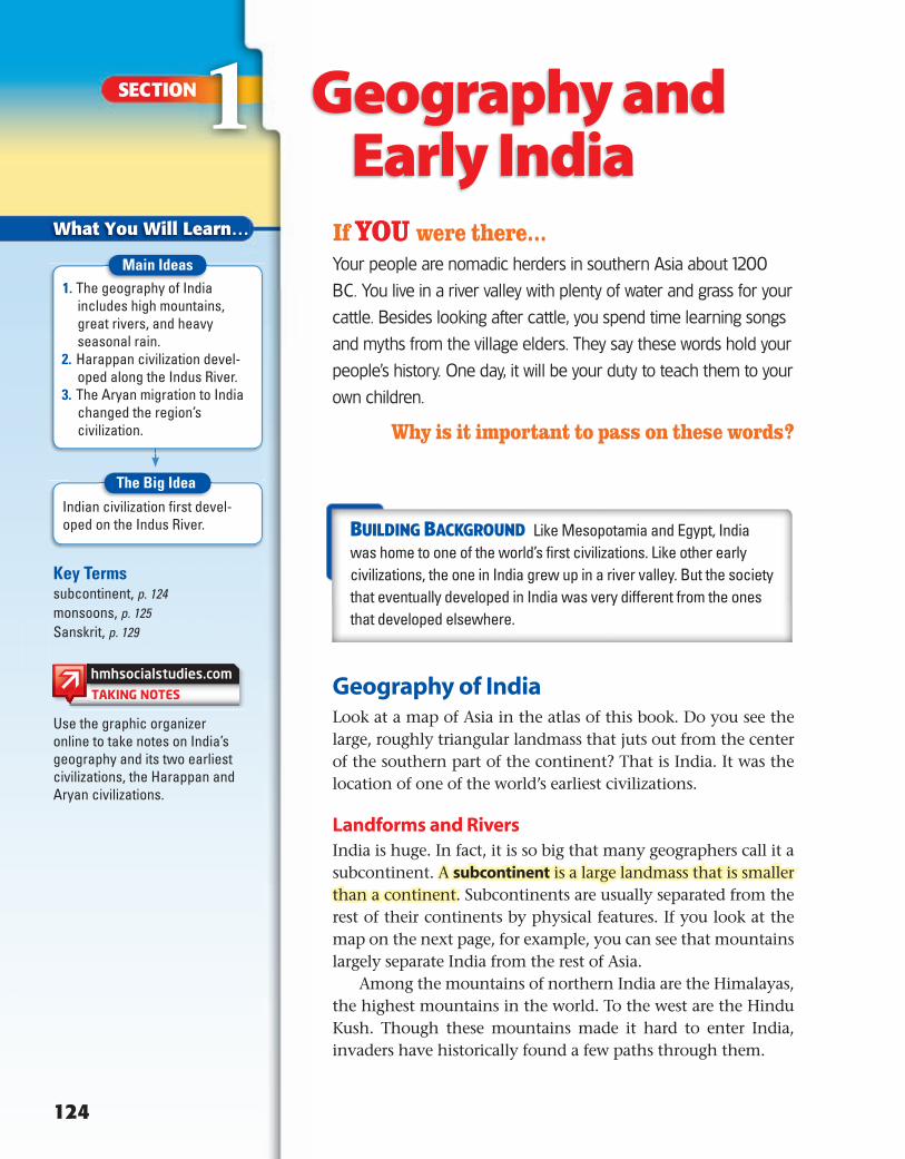
What You Will Learn…
SECTION 1If YOU were there...Your people are nomadic herders in southern Asia about 1200
BC. You live in a river valley with plenty of water and grass for your
cattle. Besides looking after cattle, you spend time learning songs
and myths from the village elders. They say these words hold your
people’s history. One day, it will be your duty to teach them to your
own children.
Why is it important to pass on these words?
BUILDING BACKGROUND Like Mesopotamia and Egypt, India was home to one of the world’s first civilizations. Like other early civilizations, the one in India grew up in a river valley. But the society that eventually developed in India was very different from the ones that developed elsewhere.
Geography of IndiaLook at a map of Asia in the atlas of this book. Do you see the large, roughly triangular landmass that juts out from the center of the southern part of the continent? That is India. It was the location of one of the world’s earliest civilizations.
Landforms and RiversIndia is huge. In fact, it is so big that many geographers call it a subcontinent. A subcontinent is a large landmass that is smaller than a continent. Subcontinents are usually separated from the rest of their continents by physical features. If you look at the map on the next page, for example, you can see that mountains largely separate India from the rest of Asia.
Among the mountains of northern India are the Himalayas, the highest mountains in the world. To the west are the Hindu Kush. Though these mountains made it hard to enter India, invaders have historically found a few paths through them.
Key Termssubcontinent, p. 124monsoons, p. 125Sanskrit, p. 129
Indian civilization first devel-oped on the Indus River.
1. The geography of India includes high mountains, great rivers, and heavy seasonal rain.
2. Harappan civilization devel-oped along the Indus River.
3. The Aryan migration to India changed the region’s civilization.
Geography and Early India
Use the graphic organizer online to take notes on India’s geography and its two earliest civilizations, the Harappan and Aryan civilizations.
Main Ideas
The Big Idea
6-8_SNLAESE485829_C05S1.indd 124 7/10/10 9:54:28 AM
80� E
70� E
90� E
10� N10� N
20� N
Kanchenjunga28,208 ft.(8,598 m)
H
IM
AL
A Y A S
EASTERN GHATSW
ES
TE
RN
GH
AT
SDECCANPLATEAU
Ganges Delta
Thar D
eser
t
(Great Indian
Des
ert)
Vindhya Range
Co
rom
and
el
C
oas
t
Malabar C
oast
Hindu Kush
80� E
70� E
90� E
10� N10� N
20� N
Tropic of Cancer
LaccadiveIslands
AndamanIslands
Indus
Riv
er
Krishna R.
Godavari River
Indus River
Gan
ges River
Yam
una R
iver
G anges R.
Ghaghara River Brahmaputra
Riv
er
Ja
mun
a
R.
ArabianSea
Bay ofBengal
AndamanSea
INDIANOCEAN
HRW World Historywh06as_c06map003aaIndia: PhysicalAPPROVED 11/15/04
N
S
W E
HRW World Historywh06as_c06loc003ba
India: Physical LocatorAPPROVED 11/15/04
4,0002,0005002000 (Sea level)Belowsea level
13,1206,5601,640
656(Sea level) 0
Belowsea level
Feet Meters
0 150 300 Miles
0 150 300 Kilometers
ELEVATION
Dry monsoon air flow(Winter)
Wet monsoon air flow(Summer)
HRW World Historywh06as_c06map003aaIndia: PhysicalLegendAPPROVED 11/15/04
ANCIENT INDIA 125
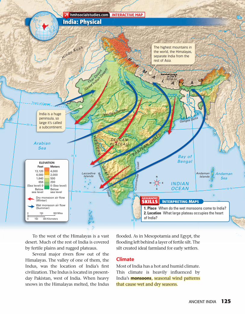
To the west of the Himalayas is a vast desert. Much of the rest of India is covered by fertile plains and rugged plateaus.
Several major rivers fl ow out of the Himalayas. The valley of one of them, the Indus, was the location of India’s fi rst civilization. The Indus is located in present-day Pakistan, west of India. When heavy snows in the Himalayas melted, the Indus
fl ooded. As in Mesopotamia and Egypt, the fl ooding left behind a layer of fertile silt. The silt created ideal farmland for early settlers.
ClimateMost of India has a hot and humid climate. This climate is heavily infl uenced by India’s monsoons , seasonal wind patternsthat cause wet and dry seasons.
India: Physical
INTERPRETING MAPS
1. Place When do the wet monsoons come to India?2. Location What large plateau occupies the heart of India?
GEOGRAPHY
SKILLS
KKaanncchheennjjuunngga28 208 fttftf
M
A
The highest mountains in the world, the Himalayas, separate India from the rest of Asia.
p c of Cancer
India is a huge peninsula, so large it ’s called a subcontinent.
6-8_SNLAESE485829_C05S1.indd 125 7/10/10 9:54:48 AM
In the summer, monsoon winds blow into India from the Indian Ocean, bringing heavy rains that can cause terrible fl oods. Some parts of India receive as much as 100 or even 200 inches of rain during this time. In the winter, winds blow down from the mountains. This forces moisture out of India and creates warm, dry winters.
READING CHECK Drawing Conclusions How do you think monsoons affected settlement in India?
Harappan CivilizationHistorians call the civilization that grew up in the Indus River Valley the Harappan (huh-RA-puhn) civilization. In addition, many Harap-pan settlements were found along the Saras-vati River, located southeast of the Indus.
Like other ancient societies you have studied, the Harappan civilization grew as irrigation and agriculture improved. As farmers began to produce surpluses of food, towns and cities appeared in India.
Life in Mohenjo DaroHistory Close-up
Mohenjo Daro was one of the two major cities of the Harappan civilization. Located next to the Indus River in what is now Pakistan, the city probably covered one square mile. The people who lived in the city enjoyed some of the most advanced comforts of their time, including indoor plumbing.
126 CHAPTER 5
Harappan merchants used a standard set of weights to measure goods such as precious stones.
6-8_SNLAESE485829_C05S1.indd 126 7/10/10 9:57:24 AM
Mohenjo Daro
Harappa
ArabianSea
Indus Riv
er
Sar
asva
ti R
iver
HI M
AL A Y A S
TharDesertThar
Desert
N
S
W E
Harappan Civilizationmswh12fs_c05map100aaHMH Middle School World Historyfirst proof 4/27/10 Spatial Graphics
Harappancivilization
Major settlement
0 100 200 Miles
0 100 200 Kilometers
Harappan Civilizationmswh12fs_c05map100caHMH Middle School World Historyfirst proof 4/27/10 Spatial Graphics
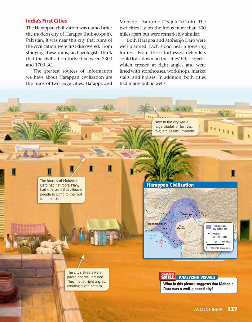
India’s First CitiesThe Harappan civilization was named after the modern city of Harappa (huh-RA-puh), Pakistan. It was near this city that ruins of the civilization were fi rst discovered. From studying these ruins, archaeologists think that the civilization thrived between 2300 and 1700 BC.
The greatest sources of information we have about Harappan civilization are the ruins of two large cities, Harappa and
Mohenjo Daro (mo-HEN-joh DAR-oh). The two cities lay on the Indus more than 300 miles apart but were remarkably similar.
Both Harappa and Mohenjo Daro were well planned. Each stood near a towering fortress. From these fortresses, defenders could look down on the cities’ brick streets, which crossed at right angles and were lined with storehouses, workshops, market stalls, and houses. In addition, both cities had many public wells.
ANALYZING VISUALS
What in this picture suggests that Mohenjo Daro was a well-planned city?
ANALYSIS
SKILL
ANCIENT INDIA 127
Harappan Civilization
Next to the city was a huge citadel, or fortress, to guard against invasions.
The houses of Mohenjo Daro had flat roofs. Many had staircases that allowed people to climb to the roof from the street.
The city’s streets were paved and well drained. They met at right angles, creating a grid pattern.
6-8_SNLAESE485829_C05S1.indd 127 7/10/10 10:00:01 AM
128 CHAPTER 5
Harappan AchievementsHarappan civilization was very advanced. Most houses had bathrooms with indoor plumbing. Artisans made excellent pottery, jewelry, ivory objects, and cotton clothing. They used high-quality tools and devel-oped a system of weights and measures.
Harappans also developed India’s fi rst writing system. However, scholars have not yet learned to read this language, so we know very little about Harappan society. Historians think that the Harappans had kings and strong central governments, but they aren’t sure. As in Egypt, the people may have worshipped the king as a god.
Harappan civilization ended by the early 1700s BC, but no one is sure why. Perhaps invaders destroyed the cities or natural disasters, like fl oods or earthquakes, caused the civilization to collapse.
READING CHECK Analyzing Why don’t we know much about Harappan civilization?
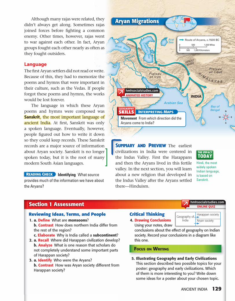
Aryan MigrationNot long after the Harappan civilization crumbled, a new group arrived in the Indus Valley. They were called the Aryans (AIR-ee-uhnz). They were originally from the area around the Caspian Sea in Central Asia. Over time, however, they became the dominant group in India.
Arrival and SpreadThe Aryans fi rst arrived in India in the 2000s BC. Historians and archaeologists believe that the Aryans crossed into India through mountain passes in the northwest. Over many centuries, they spread east and south into central India. From there they moved even farther east into the Ganges River Valley.
Much of what we know about Aryan society comes from religious writings known as the Vedas (VAY-duhs). These are collections of poems, hymns, myths, and rituals that were written by Aryan priests. You will read more about the Vedas later in this chapter.
Government and SocietyAs nomads, the Aryans took along their herds of animals as they moved. But over time, they settled in villages and began to farm. Unlike the Harappans, they did not build big cities.
The Aryan political system was also different from the Harappan system. The Aryans lived in small communities, based mostly on family ties. No single ruling authority existed. Instead, each group had its own leader, often a skilled warrior.
Aryan villages were governed by rajas (RAH-juhz). A raja was a leader who ruled a village and the land around it. Villagers farmed some of this land for the raja. They used other sections as pastures for their cows, horses, sheep, and goats.
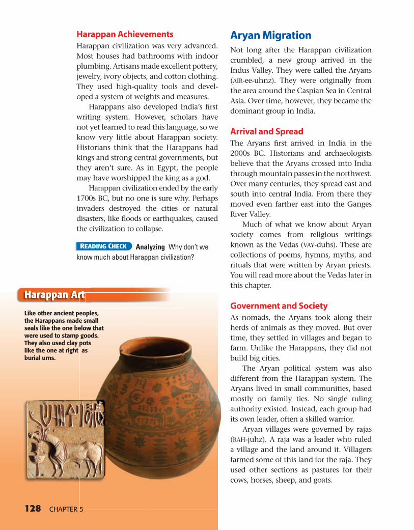
Like other ancient peoples, the Harappans made small seals like the one below that were used to stamp goods. They also used clay pots like the one at right as burial urns.
Harappan Art
6-8_SNLAESE485829_C05S1.indd 128 7/10/10 10:00:47 AM
ONLINE QUIZ
HINDU
KUSH
HI M
A L A Y A S
Plateauof TibetPlateau
of Iran
Caucasus Mts.
Arabian SeaBay ofBengal
Caspian Sea
AralSea
Black Sea
INDIA
N
S
W E
HRW World Historywh06as_c06map006aa
Aryan InvasionsAPPROVED 11/4/04
HRW World Historywh06as_c06loc006ba
Aryan Invasions Locator
APPROVED 11/4/04
0 1,000 Miles
0 1,000 Kilometers
Route of Aryans, c.1500 BC
500
500
HRW World Historywh06as_c06map006aa
Aryan InvasionsLegend
APPROVED 11/4/04
ANCIENT INDIA 129
Although many rajas were related, they didn’t always get along. Sometimes rajas joined forces before fi ghting a common enemy. Other times, however, rajas went to war against each other. In fact, Aryan groups fought each other nearly as often as they fought outsiders.
LanguageThe fi rst Aryan settlers did not read or write. Because of this, they had to memorize the poems and hymns that were important in their culture, such as the Vedas. If people forgot these poems and hymns, the works would be lost forever.
The language in which these Aryan poems and hymns were composed was Sanskrit , the most important language ofancient India. At fi rst, Sanskrit was only a spoken language. Eventually, however, people fi gured out how to write it down so they could keep records. These Sanskrit records are a major source of information about Aryan society. Sanskrit is no longer spoken today, but it is the root of many modern South Asian languages.
READING CHECK Identifying What source provides much of the information we have about the Aryans?
SUMMARY AND PREVIEW The earliest civilizations in India were centered in the Indus Valley. First the Harappans and then the Aryans lived in this fertile valley. In the next section, you will learn about a new religion that developed in the Indus Valley after the Aryans settled there—Hinduism.
Section 1 Assessment
Reviewing Ideas, Terms, and People 1. a. Defi ne What are monsoons? b. Contrast How does northern India differ from
the rest of the region? c. Elaborate Why is India called a subcontinent? 2. a. Recall Where did Harappan civilization develop? b. Analyze What is one reason that scholars do
not completely understand some important parts of Harappan society?
3. a. Identify Who were the Aryans? b. Contrast How was Aryan society different from
Harappan society?
Critical Thinking 4. Drawing Conclusions
Using your notes, draw conclusions about the effect of geography on Indian society. Record your conclusions in a diagram like this one.
Hindi, the most widely spoken Indian language, is based on Sanskrit.
THE IMPACT
TODAY
Aryan Migrations
INTERPRETING MAPS
Movement From which direction did the Aryans come to India?
GEOGRAPHY
SKILLS
Harappan society
Aryan societyGeography of
India
FOCUS ON WRITING
5. Illustrating Geography and Early Civilizations This section described two possible topics for your poster: geography and early civilizations. Which of them is more interesting to you? Write down some ideas for a poster about your chosen topic.
6-8_SNLAESE485829_C05S1.indd 129 7/10/10 10:01:08 AM