Embed Size (px)
Citation preview
INDIA METEOROLOGICAL DEPARTMENT
2013 SOUTHWEST MONSOON END OF-SEASON REPORT
HIGHLIGHTS
For the country as a whole, the rainfall for the season (June-September) was 106 % of its long period average (LPA).
Seasonal rainfall was 109% of its LPA over Northwest India, 123% of its LPA over Central India, 115% of its LPA over south Peninsula and 72% of its LPA over Northeast (NE) India.
Out of the total 36 meteorological subdivisions, 14 subdivisions constituting 48% of the total area of the country received excess season rainfall, 16 subdivisions (38% of the total area of the country) received normal season rainfall and the remaining 6 subdivisions (14% of the total area of the country) received deficient season rainfall.
Monthly rainfall over the country as a whole was 132% of LPA in June, 106% of LPA in July, 98% of LPA in August and 86% of LPA in September.
Out of the total of 641 districts, 100 were affected by moderate meteorological drought (seasonal rainfall deficiency of 26% to 50%), while 39 were affected by severe meteorological drought (seasonal rainfall deficiency of 51% to 99%)
Southwest monsoon current advanced over the Andaman Sea 3 days earlier than its normal data of 20th May and set in over Kerala on its normal date of 1st June. The southwest monsoon covered the entire country by 16th June, about 1 month earlier than its normal date of 15th July.
The withdrawal of monsoon from west Rajasthan commenced on 9th September compared to its normal date of 1st September. After 19th, further withdrawal of southwest monsoon was stalled with the successive formation of two low pressure areas and their westward movement across the central parts of the country.
During the season, 2 monsoon depressions and 16 monsoon low pressure areas were formed as against the normal of 6 monsoon depressions and 6 monsoon low pressure areas per season.
The forecast for monsoon onset over Kerala for this year was correct, which is the ninth consecutive correct forecast for this event since issuing of forecast for the event was started in 2005.
The operational long range forecasts for the 2013 southwest monsoon season rainfall over the country as whole and that over 3 broad geographical regions i.e. Northwest India, Central India and South Peninsula were an underestimate and for Northeast India, it was an overestimate.
However, forecast for the rainfall over the country as a whole during the monsoon months of July, August and September and that for the second half of the monsoon season were within the forecast limits and accurate.
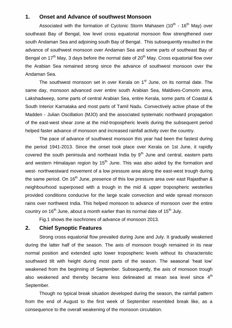
1. Onset and Advance of southwest Monsoon
Associated with the formation of Cyclonic Storm Mahasen (10th - 16th May) over
southeast Bay of Bengal, low level cross equatorial monsoon flow strengthened over
south Andaman Sea and adjoining south Bay of Bengal. This subsequently resulted in the
advance of southwest monsoon over Andaman Sea and some parts of southeast Bay of
Bengal on 17th May, 3 days before the normal date of 20th May. Cross equatorial flow over
the Arabian Sea remained strong since the advance of southwest monsoon over the
Andaman Sea.
The southwest monsoon set in over Kerala on 1st June, on its normal date. The
same day, monsoon advanced over entire south Arabian Sea, Maldives-Comorin area,
Lakshadweep, some parts of central Arabian Sea, entire Kerala, some parts of Coastal &
South Interior Karnataka and most parts of Tamil Nadu. Convectively active phase of the
Madden - Julian Oscillation (MJO) and the associated systematic northward propagation
of the east-west shear zone at the mid-tropospheric levels during the subsequent period
helped faster advance of monsoon and increased rainfall activity over the country.
The pace of advance of southwest monsoon this year had been the fastest during
the period 1941-2013. Since the onset took place over Kerala on 1st June, it rapidly
covered the south peninsula and northeast India by 9th June and central, eastern parts
and western Himalayan region by 15th June. This was also aided by the formation and
west- northwestward movement of a low pressure area along the east-west trough during
the same period. On 16th June, presence of this low pressure area over east Rajasthan &
neighbourhood superposed with a trough in the mid & upper tropospheric westerlies
provided conditions conducive for the large scale convection and wide spread monsoon
rains over northwest India. This helped monsoon to advance of monsoon over the entire
country on 16th June, about a month earlier than its normal date of 15th July.
Fig.1 shows the isochrones of advance of monsoon 2013.
2. Chief Synoptic Features
Strong cross equatorial flow prevailed during June and July. It gradually weakened
during the latter half of the season. The axis of monsoon trough remained in its near
normal position and extended upto lower tropospheric levels without its characteristic
southward tilt with height during most parts of the season. The seasonal ‘heat low’
weakened from the beginning of September. Subsequently, the axis of monsoon trough
also weakened and thereby became less delineated at mean sea level since 4th
September.
Though no typical break situation developed during the season, the rainfall pattern
from the end of August to the first week of September resembled break like, as a
consequence to the overall weakening of the monsoon circulation.
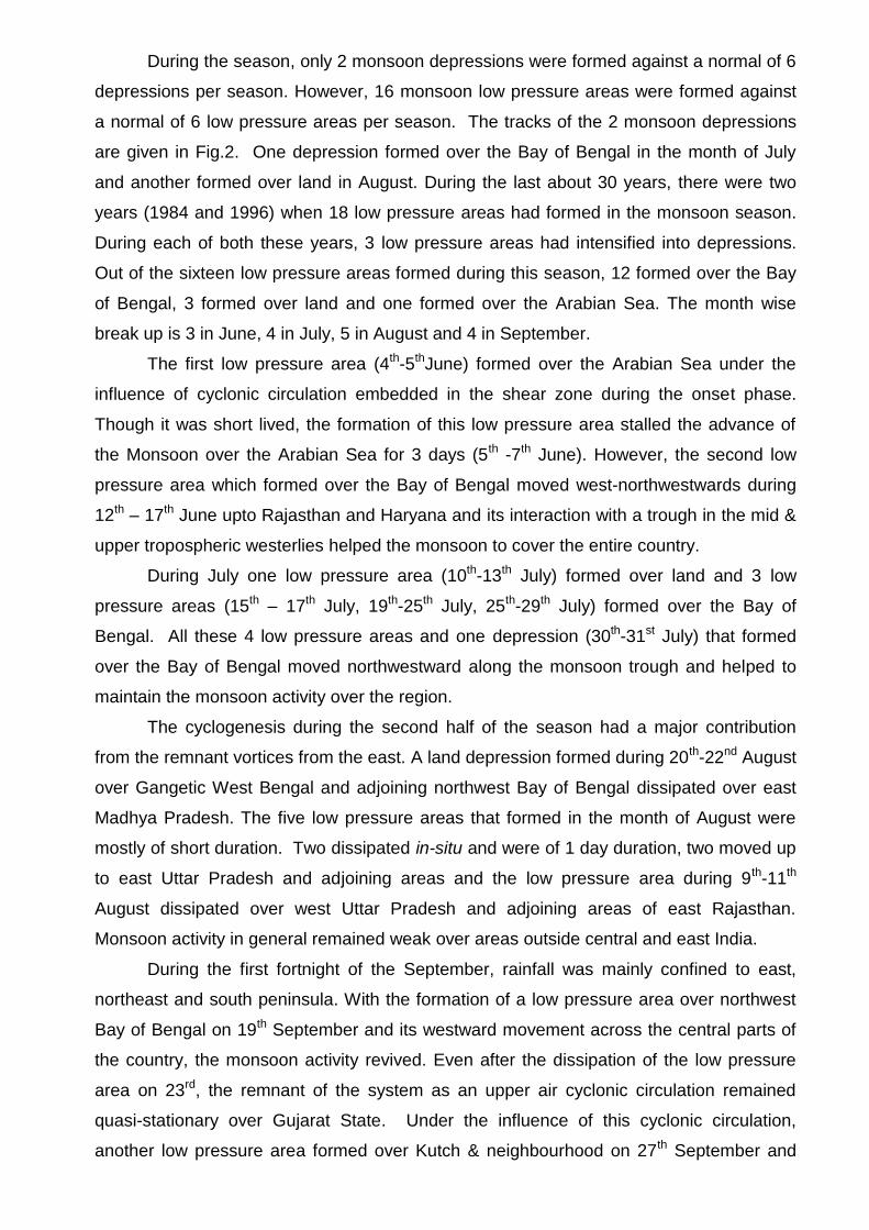
During the season, only 2 monsoon depressions were formed against a normal of 6
depressions per season. However, 16 monsoon low pressure areas were formed against
a normal of 6 low pressure areas per season. The tracks of the 2 monsoon depressions
are given in Fig.2. One depression formed over the Bay of Bengal in the month of July
and another formed over land in August. During the last about 30 years, there were two
years (1984 and 1996) when 18 low pressure areas had formed in the monsoon season.
During each of both these years, 3 low pressure areas had intensified into depressions.
Out of the sixteen low pressure areas formed during this season, 12 formed over the Bay
of Bengal, 3 formed over land and one formed over the Arabian Sea. The month wise
break up is 3 in June, 4 in July, 5 in August and 4 in September.
The first low pressure area (4th-5thJune) formed over the Arabian Sea under the
influence of cyclonic circulation embedded in the shear zone during the onset phase.
Though it was short lived, the formation of this low pressure area stalled the advance of
the Monsoon over the Arabian Sea for 3 days (5th -7th June). However, the second low
pressure area which formed over the Bay of Bengal moved west-northwestwards during
12th – 17th June upto Rajasthan and Haryana and its interaction with a trough in the mid &
upper tropospheric westerlies helped the monsoon to cover the entire country.
During July one low pressure area (10th-13th July) formed over land and 3 low
pressure areas (15th – 17th July, 19th-25th July, 25th-29th July) formed over the Bay of
Bengal. All these 4 low pressure areas and one depression (30th-31st July) that formed
over the Bay of Bengal moved northwestward along the monsoon trough and helped to
maintain the monsoon activity over the region.
The cyclogenesis during the second half of the season had a major contribution
from the remnant vortices from the east. A land depression formed during 20th-22nd August
over Gangetic West Bengal and adjoining northwest Bay of Bengal dissipated over east
Madhya Pradesh. The five low pressure areas that formed in the month of August were
mostly of short duration. Two dissipated in-situ and were of 1 day duration, two moved up
to east Uttar Pradesh and adjoining areas and the low pressure area during 9th-11th
August dissipated over west Uttar Pradesh and adjoining areas of east Rajasthan.
Monsoon activity in general remained weak over areas outside central and east India.
During the first fortnight of the September, rainfall was mainly confined to east,
northeast and south peninsula. With the formation of a low pressure area over northwest
Bay of Bengal on 19th September and its westward movement across the central parts of
the country, the monsoon activity revived. Even after the dissipation of the low pressure
area on 23rd, the remnant of the system as an upper air cyclonic circulation remained
quasi-stationary over Gujarat State. Under the influence of this cyclonic circulation,
another low pressure area formed over Kutch & neighbourhood on 27th September and

became less marked on 30th. The last low pressure area of the season formed over
northwest Bay of Bengal and adjoining coastal areas of West Bengal and Odisha on 28th
evening and persisted there till the last day of the season.
3. Floods and Droughts
Incessant rainfall associated with the monsoon low pressure systems and active
monsoon conditions often caused flood situations over various states during different parts
of the season. The interaction between the monsoon low and the trough in the westerlies
during the advance phase of monsoon caused severe floods during 16th–17th June over
Uttarakhand. Downstream convergence of the stronger than normal low level winds
during the first half of the season led to several events of incessant heavy rains and floods
over Kerala. Towards the end of the season, Gujarat and adjoining areas of south
Rajasthan experienced extremely heavy rainfall and flood situation due to the revival of
the monsoon activity associated with a cyclonic circulation that remained quasi-stationary
for few days over Gujarat and neighboring areas. Apart from these, some other sub-
divisions/states which experienced flood situations were Assam & Meghalaya, West
Bengal & Sikkim, Odisha, Jharkhand, Bihar, Uttar Pradesh, Haryana, Himachal Pradesh,
Madhya Pradesh, Gujarat, Vidarbha, Chhattisgarh, Andhra Pradesh and Karnataka. The
floods occurred in Assam & Meghalaya, Jharkhand and Bihar were primarily due to the
flooding of the rivers because of the heavy rainfall in the upper reaches of catchment
areas.
During most part of the season, many districts of Arunachal Pradesh, Assam &
Meghalaya, Nagaland-Manipur-Mizoram-Tripura, Jharkhand and Bihar experienced
moderate to extreme drought conditions.
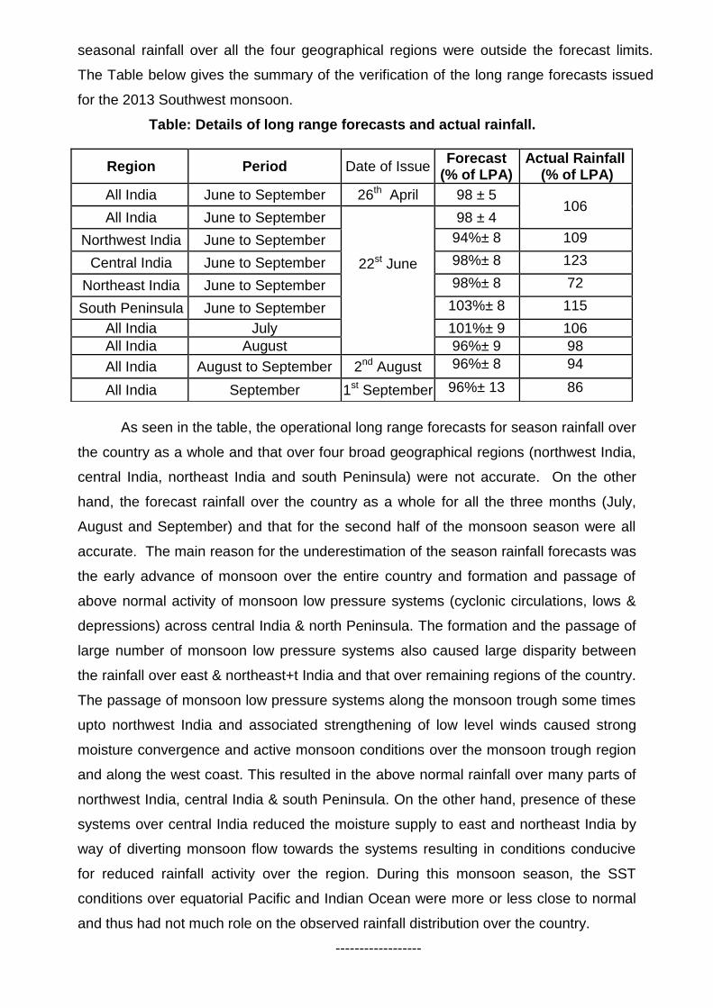
4. Withdrawal of southwest Monsoon
The weather over the western parts of Rajasthan remained mainly dry for more
than a fortnight (from 27th August). A change over in the lower tropospheric circulation
pattern over the region from cyclonic to anti cyclonic during 8th - 9th September resulted in
the withdrawal of southwest monsoon from the region. Hence the withdrawal of southwest
monsoon commenced from 9th September and the withdrawal line passed through
Ganganagar, Bikaner and Barmer during 9th-18th September. The Southwest Monsoon
withdrew from entire Jammu & Kashmir, Himachal Pradesh and Punjab; some parts of
Haryana; some more parts of Rajasthan and some parts of Kutch on 19th and the
withdrawal line passed through Kalpa, Hissar, Jodhpur and Naliya. However, an almost
complete revival in the monsoon activity occurred from the 3rd week of September. With
the successive formation of two low pressure areas and their westward movement across
the central parts of the country caused the east-west trough to remain active contributing
to above normal rainfall during this period. This development has stalled the further
withdrawal of southwest monsoon.
Fig.3 shows the isochrones of withdrawal of monsoon 2013.
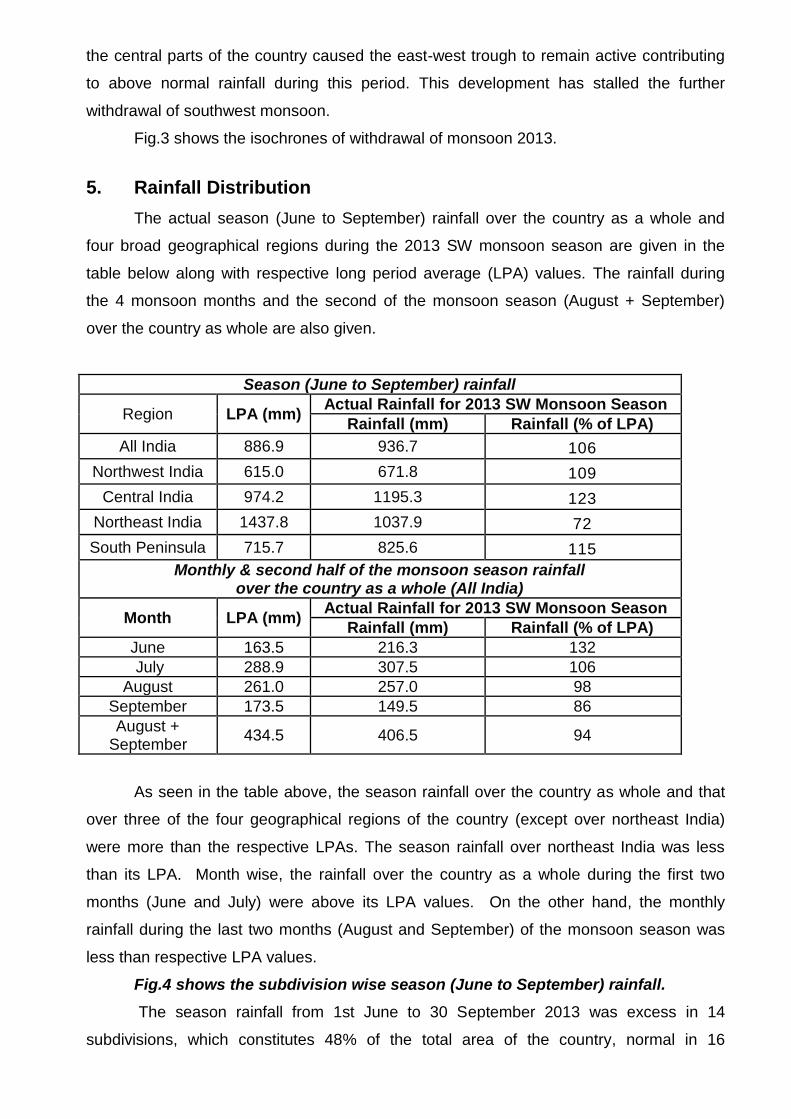
5. Rainfall Distribution
The actual season (June to September) rainfall over the country as a whole and
four broad geographical regions during the 2013 SW monsoon season are given in the
table below along with respective long period average (LPA) values. The rainfall during
the 4 monsoon months and the second of the monsoon season (August + September)
over the country as whole are also given.
Season (June to September) rainfall
Region LPA (mm) Actual Rainfall for 2013 SW Monsoon Season
Rainfall (mm) Rainfall (% of LPA)
All India 886.9 936.7 106
Northwest India 615.0 671.8 109
Central India 974.2 1195.3 123
Northeast India 1437.8 1037.9 72
South Peninsula 715.7 825.6 115
Monthly & second half of the monsoon season rainfall over the country as a whole (All India)
Month LPA (mm) Actual Rainfall for 2013 SW Monsoon Season
Rainfall (mm) Rainfall (% of LPA)
June 163.5 216.3 132
July 288.9 307.5 106
August 261.0 257.0 98
September 173.5 149.5 86
August + September
434.5 406.5 94
As seen in the table above, the season rainfall over the country as whole and that
over three of the four geographical regions of the country (except over northeast India)
were more than the respective LPAs. The season rainfall over northeast India was less
than its LPA. Month wise, the rainfall over the country as a whole during the first two
months (June and July) were above its LPA values. On the other hand, the monthly
rainfall during the last two months (August and September) of the monsoon season was
less than respective LPA values.
Fig.4 shows the subdivision wise season (June to September) rainfall.
The season rainfall from 1st June to 30 September 2013 was excess in 14
subdivisions, which constitutes 48% of the total area of the country, normal in 16
meteorological subdivisions (38% of the total area of the country) and deficient in 6
meteorological subdivisions (14% the total area of the country).
Fig.5 shows the subdivision wise monthly rainfall.
In June, except for 3 subdivisions from extreme northeast India (Arunachal
Pradesh, Assam and Meghalaya, and Nagaland, Manipur Mizoram & Tripura), which
received deficient rainfall, all the other subdivisions (33 out of 36) received excess (25
subdivisions) or normal (8 subdivisions) rainfall. In July, 10 subdivisions from northern,
eastern and northeastern parts of the country and one in the extreme southeast (Tamil
Nadu and Pondicherry) received deficient rainfall. Out of the 25 remaining subdivisions,
12 subdivisions received normal and 13 subdivisions, majority of which are from central
India and along the west coast, received excess rainfall. In August, rainfall activity
weakened compared to the first two months but was close to normal. During August, 8
subdivisions received excess rainfall, 18 subdivisions received normal rainfall and
remaining 10 subdivisions received deficient rainfall. The excess subdivisions were
Jammu & Kahsmir, Punjab, west and east Rajasthan, west and east Madhya Pradesh,
Gangetic West Bengal and Tamil Nadu. The deficient subdivisions were 3 of the 4
subdivisions of Maharashtra (except Vidarbha), north interior Karnataka, Lakshadweep,
Orissa, Bihar, and 3 subdivisions from extreme northeast India.
In September, the rainfall activity reduced further and 17 subdivisions from north,
east, northeast and central India received deficient or scantly rainfall. The 4 scantly
subdivisions were Punjab, west and east Uttar Pradesh and east Madhya Pradesh. Out of
the remaining 19 subdivisions, 9 subdivisions were excess and 10 subdivisions were
normal. The excess subdivisions were, west Rajasthan, 2 subdivisions of Gujarat,
Madhya Maharashtra, 3 subdivisions of Karnataka, Kerala and Rayalaseema.
From the monthly distribution, it can be clearly seen that during most part of the
season, the 3 subdivisions from the extreme northeast received deficient rainfall. On the
other hand, most of the subdivisions from the central India and neighboring northwest
India and south Peninsula received excess rainfall during the first 3 months of the season.
However no subdivisions experienced scantly rainfall during first 3 months of the season.
Only in September that 4 subdivisions received scantly rainfall. Overall, there was
noticeable disparity in the spatial distribution of the rainfall with below normal or deficient
rainfall over east and northeast India and above normal or excess rainfall over most of the
other regions.
Figures 6 and 7 depict the all India weekly and cumulative weekly rainfall
anomaly expressed as percentage departure from the LPA.
The all India weekly rainfall anomalies during 8 of the 9 weeks of the first half of the
monsoon season were positive. The only exception was the negative rainfall anomaly

during the week ending 10th July. On the other hand, during 6 out of the 8 weeks (except
weeks ending 21st August and 21st Sept) of the second half of the season, the weekly
rainfall anomalies were negative. Due to above normal all India rainfall during most of the
weeks of the first half of the monsoon season, the all India cumulative weekly rainfall
anomalies were positive throughout the season.
6. Verification of the Long Range Forecasts
Based on an indigenously developed statistical model, it was predicted on 15th May
2013 that monsoon will set in over Kerala on 3rd June with a model error of ±4days. The
forecast came correct as the actual monsoon onset over Kerala took place on the normal
date of 1st June, 2 days earlier than the forecasted date. Thus, this is the ninth
consecutive correct operational forecast for the date of monsoon onset over Kerala since
issuing of operational forecast for the event was started in 2005.
This year, the first stage long range forecast for the season (June-September)
rainfall for the country as a whole was issued on 26th April and its update was issued on
14th June. Both the forecast were same (98% of LPA) but with a model error of ±5% of
LPA for the first stage forecast and that of ±4% of LPA for the updated forecast. However,
the actual season rainfall for the country as a whole (106% of LPA) was more than the
forecast by 8% of LPA, and therefore was above the upper forecast limit of 102% of LPA.
The forecast for the second half of the monsoon season (August –September) for the
country as a whole issued in August was 96% with a model error of 8% of LPA against the
actual rainfall of 94% of LPA. Thus the forecast for the rainfall during the second half of
the monsoon season over the country as a whole was within the forecast limit.
The forecasts for monthly rainfall over the country as a whole for the months of
July, August issued in June were 101% & 96% respectively with a model error of ± 9%.
The forecast for rainfall over the country as a whole for the September issued in August
was 96% of LPA with a model error of ± 13%. The actual rainfall during July, August and
September were 106%, 98% & 86% of respective LPA values. Thus the forecast during
July, August and September were within the forecasts limits.
Considering the four broad geographical regions of India, the season rainfall was
expected to be 94% of its LPA over northwest India, 98% of LPA over Central India, 98%
of LPA over northeast India and 103% of LPA over South Peninsula all with a model error
of ± 8%. The actual rainfalls over northwest India, central India, northeast India and south
Peninsula were 109%, 123%, 72% and 115% of the LPA respectively. Thus forecast for
the season rainfall over northwest India, central India and south Peninsula were all
underestimates to the actual rainfall by 15% of LPA, 25% of LPA and 12% of LPA
respectively. On the other hand, the forecast for the season rainfall over the northeast
India was overestimate to the actual rainfall by 26% of LPA. Thus all the forecast for
seasonal rainfall over all the four geographical regions were outside the forecast limits.
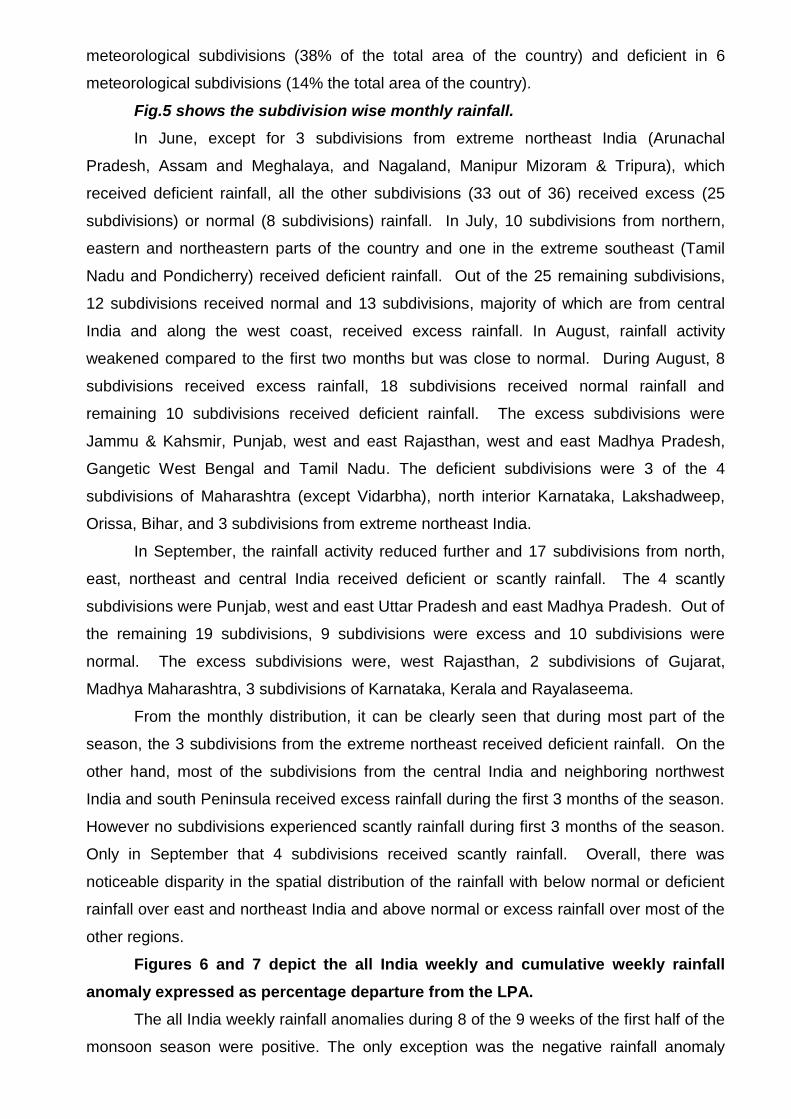
The Table below gives the summary of the verification of the long range forecasts issued
for the 2013 Southwest monsoon.
Table: Details of long range forecasts and actual rainfall.
As seen in the table, the operational long range forecasts for season rainfall over
the country as a whole and that over four broad geographical regions (northwest India,
central India, northeast India and south Peninsula) were not accurate. On the other
hand, the forecast rainfall over the country as a whole for all the three months (July,
August and September) and that for the second half of the monsoon season were all
accurate. The main reason for the underestimation of the season rainfall forecasts was
the early advance of monsoon over the entire country and formation and passage of
above normal activity of monsoon low pressure systems (cyclonic circulations, lows &
depressions) across central India & north Peninsula. The formation and the passage of
large number of monsoon low pressure systems also caused large disparity between
the rainfall over east & northeast+t India and that over remaining regions of the country.
The passage of monsoon low pressure systems along the monsoon trough some times
upto northwest India and associated strengthening of low level winds caused strong
moisture convergence and active monsoon conditions over the monsoon trough region
and along the west coast. This resulted in the above normal rainfall over many parts of
northwest India, central India & south Peninsula. On the other hand, presence of these
systems over central India reduced the moisture supply to east and northeast India by
way of diverting monsoon flow towards the systems resulting in conditions conducive
for reduced rainfall activity over the region. During this monsoon season, the SST
conditions over equatorial Pacific and Indian Ocean were more or less close to normal
and thus had not much role on the observed rainfall distribution over the country.
------------------
Region Period Date of Issue Forecast
(% of LPA) Actual Rainfall
(% of LPA)
All India June to September 26th April 98 ± 5 106
All India June to September
22st June
98 ± 4
Northwest India June to September 94%± 8 109
Central India June to September 98%± 8 123
Northeast India June to September 98%± 8 72
South Peninsula June to September 103%± 8 115
All India July 101%± 9 106
All India August 96%± 9 98
All India August to September 2nd August 96%± 8 94
All India September 1st September 96%± 13 86

Fig.1: Progress of Southwest Monsoon – 2013
Fig.2: Track of the monsoon depressions
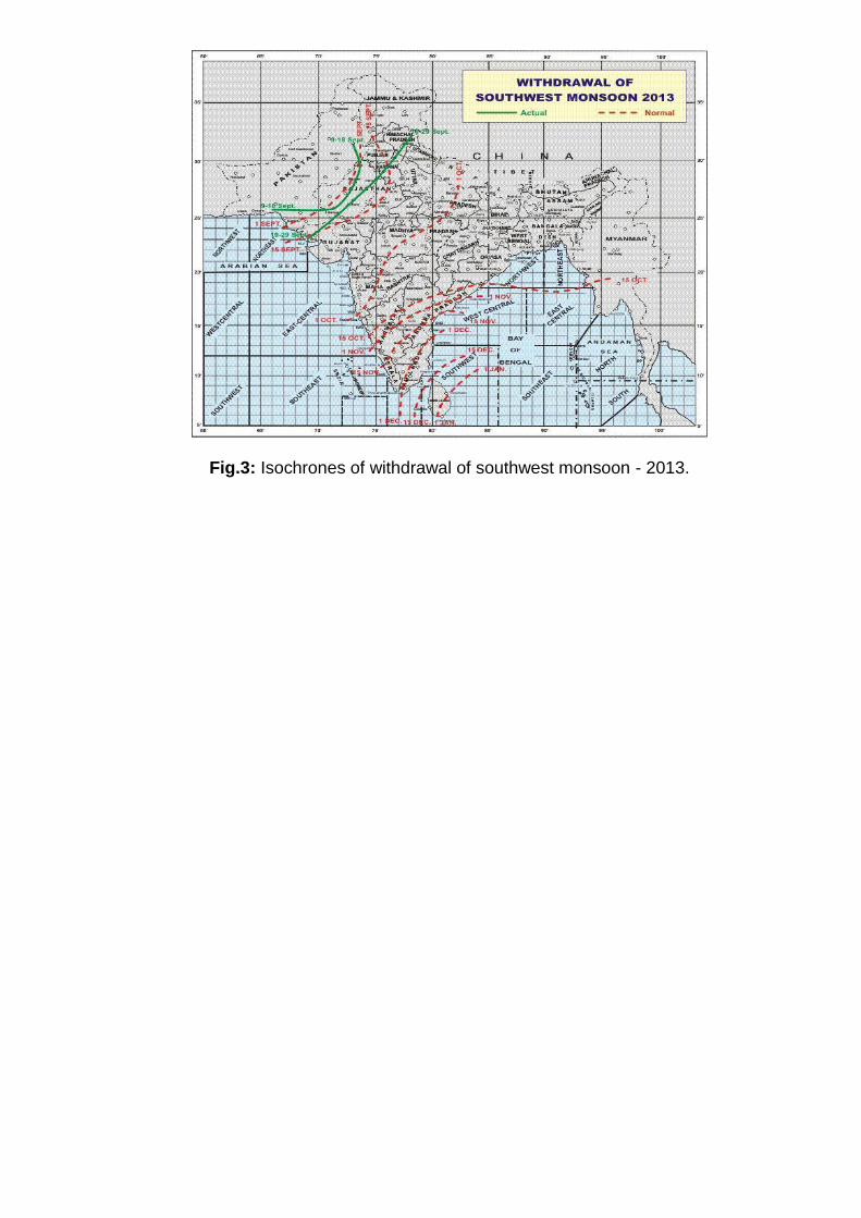
Fig.3: Isochrones of withdrawal of southwest monsoon - 2013.
Fig.4: Sub-divisionwise rainfall distribution over India during southwest monsoon season (June to September) – 2013
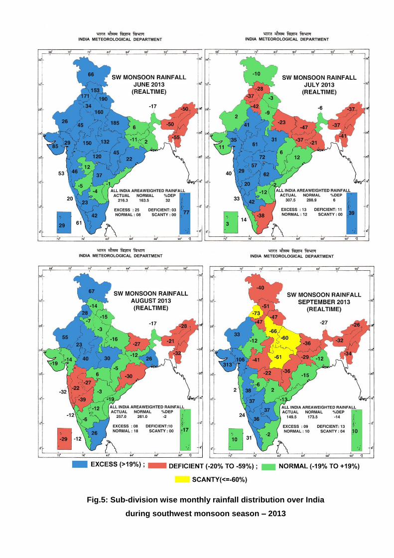
Fig.5: Sub-division wise monthly rainfall distribution over India
during southwest monsoon season – 2013
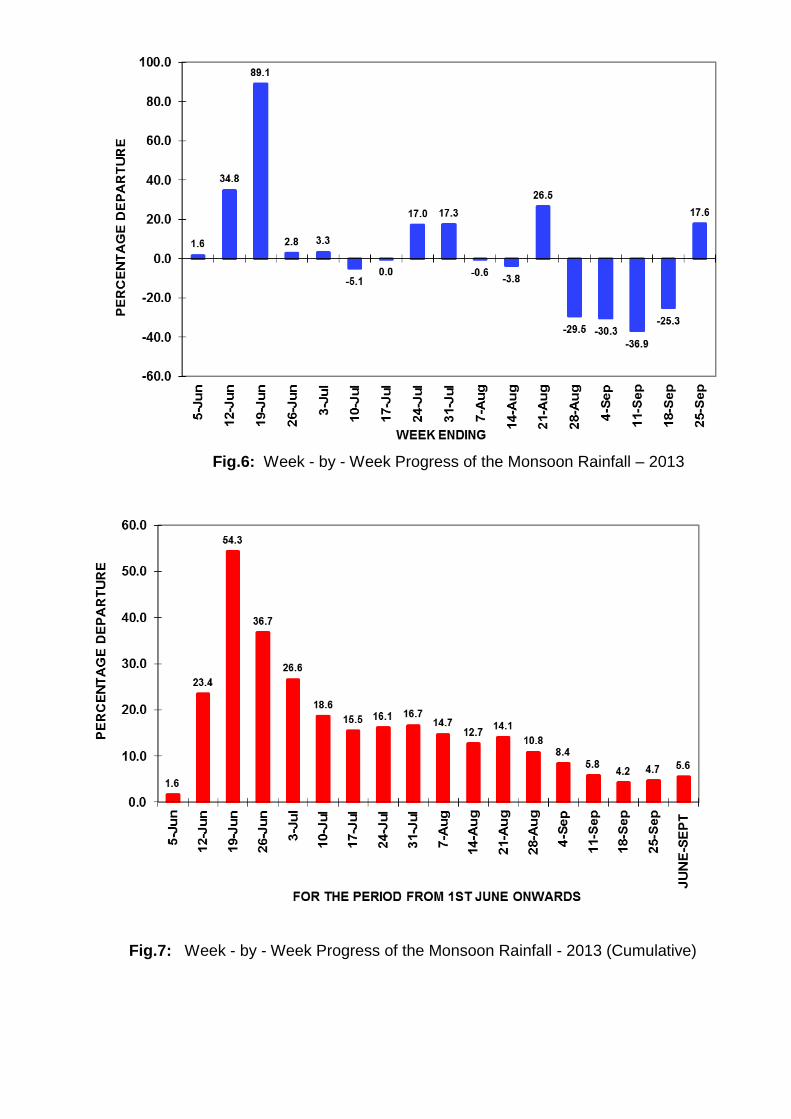
Fig.6: Week - by - Week Progress of the Monsoon Rainfall – 2013
Fig.7: Week - by - Week Progress of the Monsoon Rainfall - 2013 (Cumulative)