Embed Size (px)
Citation preview
The Redington Wind Farm
Section 1: Development Description
Redington Wind Farm – Joint MDEP / LURC Permit Application
Page ii
Section 1 – Development Description
Table of Contents
A. Redington Wind Farm Narrative.................................................................................. 1 Executive Summary .................................................................................................................. 1 Key Facts Table......................................................................................................................... 4 Where to Find LURC Permit Requirements in this Application ......................................... 8 Where to Find DEP Permit Requirements in this Application........................................... 14
1. Development Objectives, Purpose of D-PD and Need ................................................ 15 Objectives................................................................................................................................. 15 Demonstrated Need, Benefits and No Undue Adverse Effect ............................................. 15
Significant Renewable Energy............................................................................................................ 15 Stable Electricity Prices for Customers............................................................................................... 16 Hedge Against Gas and Oil Prices ...................................................................................................... 17 Transmission and Interconnect Studies............................................................................................... 18 Ongoing Economic Sustainability ...................................................................................................... 19 Supports Maine’s Renewable Energy Policy ...................................................................................... 20 Jobs, Taxes, and Access...................................................................................................................... 23 Environmental Benefits ...................................................................................................................... 24 No Undue Adverse Effect, Fitting Harmoniously into the Environment ............................................ 24
Outreach Activities ................................................................................................................. 26 Public Opinion Surveys and Results ................................................................................................... 27
2. Existing Facilities and Uses ........................................................................................ 27 Redington Township Facilities ........................................................................................................... 27 U.S. Navy/SERE School..................................................................................................................... 28 Appalachian Trail................................................................................................................................ 28 Dallas Company, Stratton Maine ........................................................................................................ 28 Plum Creek Timber Company, Inc. .................................................................................................... 28 International Paper, Coplin Plantation ................................................................................................ 29 Boralex Biomass Generation Facility, Stratton, Maine....................................................................... 29
3. Consistency with LURC Land Use and D-PD Zoning ............................................... 29 Criteria for Approval of a Preliminary Development Plan ................................................................. 30 1). Conforms with the Comprehensive Land Use Plan ....................................................................... 30 2). Incorporates Environmental / Resource Protection ....................................................................... 35 3). Utilizes the Best Reasonably Available Site.................................................................................. 35 4). Conserves Productive Forest Land ................................................................................................ 38 5). Incorporates High Quality Planning and Design ........................................................................... 38 6). Self-Sufficient with Regard to Public Services ............................................................................. 38 7). Provides Safe and Efficient Traffic Circulation............................................................................. 38 8). Reduces Pollution & Energy Consumption ................................................................................... 39 9). Separate from Existing Developed Areas ...................................................................................... 40 10). Greater than 50 Contiguous Acres............................................................................................... 40 11). 400’ Minimum Distance from Property Lines............................................................................. 40 12). Water, Road, Fire, Security and Solid Waste .............................................................................. 42
Description of Activities.......................................................................................................... 43 Uses requiring a permit ....................................................................................................................... 43
Redington Wind Farm – Joint MDEP / LURC Permit Application
Page iii
Section 1 – Development Description
Uses allowed without a permit subject to LURC standards................................................................ 45 Uses allowed without a permit............................................................................................................ 45
4. Description of the Technical Components.................................................................. 46 Description of the Wind Turbine – Vestas V90.................................................................................. 47
Towers............................................................................................................................................ 48 Nacelle ........................................................................................................................................... 48 Blades............................................................................................................................................. 49
Lighting for Navigation ...................................................................................................................... 49 Turbine Sites and Foundations............................................................................................................ 50 Roads & Bridges ................................................................................................................................. 52
Electrical Transmission System............................................................................................. 54 34.5kV Transmission Lines and Substation........................................................................................ 55 115kV Transmission Line and Grid Interconnect ............................................................................... 57
Maintenance Facility............................................................................................................... 58 Turbine Delivery and Erection .............................................................................................. 58
5 . Decommissioning........................................................................................................ 59 Decommissioning of wind power projects............................................................................. 59 Policy Implications.................................................................................................................. 59 Wind Farms: probability and risk......................................................................................... 60
B. Topographic (Project) Map......................................................................................... 63 1. Project Base Map ................................................................................................................ 63 2. Ownership Map................................................................................................................... 63 3. LURC Zoning Maps............................................................................................................ 63
C. Construction Plan........................................................................................................ 63 1. Construction sequence (major aspects and timeframes) ................................................. 63 2. Construction Schedule ........................................................................................................ 65
D. Design Drawings ......................................................................................................... 65 1. Development Facilities ........................................................................................................ 65
Road Design Length/cross-sections for roads..................................................................................... 65 Bridges ................................................................................................................................................ 66 Parking, traffic .................................................................................................................................... 66 Dimensions, Foundation design of Maintenance Center..................................................................... 66 Electrical Design - collector system, power lines and substation ....................................................... 66
2. Site Work ............................................................................................................................. 66 Foundation Designs of Wind Turbines ............................................................................................... 66
3. Existing Facilities ................................................................................................................ 66 References ........................................................................................................................ 67
E. Appendices (located on document CD)....................................................................... 68 1.0 – Project Base Map ........................................................................................................... 68
Redington Wind Farm – Joint MDEP / LURC Permit Application
Page iv
Section 1 – Development Description
1.1 – LURC Land Use Guidance Maps ................................................................................. 68 Project Base Map with LURC Zones Identified (PDF) ...................................................................... 68 Redington Township (PDF) ................................................................................................................ 68 Coplin Plantation (PDF) ..................................................................................................................... 68 Wyman Township (PDF).................................................................................................................... 68
1.2 (P-SG) Soil and Geology Protection Subdistrict Detail Map ........................................ 68 2.0 – Road Design Narrative .................................................................................................. 68
2.1 C-Series Mountain Road Maps - Black Nubble & Redington ...................................................... 68 2.2 Road Section Detail - "Toolbox" of road section designs............................................................. 68 2.3 W-Series Mountain Drainage Analysis Maps............................................................................... 68 2.4 Cut / Fill Road Analysis Detail ..................................................................................................... 68 2.5 Slope Maps ................................................................................................................................... 68 2.6 Narrow Road Specification........................................................................................................... 68 2.7 Deluca-Hoffman Site Visit Notes ................................................................................................. 68
3.0 – Road and Substation Wetland Detail Maps................................................................. 68 4.0 – Bridge Design Narrative ................................................................................................ 68
4.1 – Bridge Design Drawings............................................................................................................ 68 4.2 – Bridge Crossing Locations......................................................................................................... 68
5.0 – Electrical System ............................................................................................................ 68 5.1 – Collector System and Substation Design ................................................................................... 68 5.2 – Collector System Design Appendices ........................................................................................ 68 5.3 – Transmission Line Construction Plan ........................................................................................ 68 5.4 – CMP System Impact Study ........................................................................................................ 68 5.5 – E Series Maps ............................................................................................................................ 68
E1 : Black Nubble Transmission Line Map.................................................................................... 68 E2 : Redington Transmission Line Lower Map.............................................................................. 68 E3 : Redington Transmission Line Upper Map.............................................................................. 68
5.6 – Turbine SCADA System Details ............................................................................................... 69 SCADA Network Specifications ..................................................................................................... 69 Fiber Optic Cable Specification..................................................................................................... 69
6.0 – Vestas V90 General Specifications ............................................................................... 69 7.0 – Wind Turbine Foundation Details................................................................................ 69
Patrick & Henderson Design............................................................................................................... 69 Gravity Type ....................................................................................................................................... 69 Rock Anchored ................................................................................................................................... 69
7.1 – Patrick & Henderson Drawings (Preferred Design) ................................................... 69 Foundation Design Drawing ............................................................................................................... 69 Foundation Installation Photo Gallery ................................................................................................ 69
8.0 – Turbine Transportation and Assembly........................................................................ 69 8.1 – Transportation Images................................................................................................................ 69 8.2 – Turbine Installation Video (Vestas promo)................................................................................ 69 8.3 – Vestas V90 Road & Transport Specifications............................................................................ 69
9.0 – FAA Lighting.................................................................................................................. 69 9.1 – Turbine Latitude/Longitude Coordinates ................................................................................... 69 9.2 – FAA Lighting Map .................................................................................................................... 69 9.3 – Light Beacon Light Distribution Diagram ................................................................................. 69
10.0 – Demonstrated Need...................................................................................................... 69
Redington Wind Farm – Joint MDEP / LURC Permit Application
Page v
Section 1 – Development Description
10.1 – Electricity Shopping Becoming Essential ................................................................................ 69 10.2 – Windfall from the Wind Farm.................................................................................................. 69 10.3 – U.S. Dept. of Energy White Paper ........................................................................................... 69 10.4 – Fuel Diversity Need - ISO NE Report ..................................................................................... 69 10.5 – DOE Maine Wind Energy Map................................................................................................ 69 10.6 – NRCM Data on Maine Dams................................................................................................... 69 10.7 – Pollution Avoided Spreadsheet ................................................................................................ 69 10.8 – PUC Executive Summary on MWEA...................................................................................... 69
11.0 – Public Support.............................................................................................................. 69 11.1 – Supporters Database List ......................................................................................................... 70 11.2 – Hiker Support Letters............................................................................................................... 70
12.0 – Road Reference Photo Collection ............................................................................... 70 12.1 – Existing Bridge Images 1......................................................................................................... 70 12.2 – Existing Bridge Images 2......................................................................................................... 70 12.3 – Map/Photo Key Writeup for Above Images ............................................................................ 70 12.4 – Existing Bridge, Road and Terrain Photos............................................................................... 70 12.5 – Map/Photo Key Writeup for Above Image .............................................................................. 70
Redington Wind Farm – Joint MDEP / LURC Permit Application
Page 1
Section 1 – Development Description
A. Redington Wind Farm Narrative Executive Summary
With this application, Redington Mountain Windpower, LLC (RMW), managed by Endless Energy Corporation (EEC), proposes to rezone approximately 1,004 acres of its own land to a Planned Development Subdistrict (D-PD) pursuant to the Land Use Regulatory Commission’s (LURC’s) Land Use Plan, Chapter 10.21,G. Currently 1000.5 acres of owned property is designated a Mountain Area Protection Subdistrict (P-MA) and 3.5 acres on Black Nubble is designated a Soils and Geology Protection Subdistrict (P-SG). Refer to Land Use Guidance maps in Appendix 1.1 and the (P-SG) Soil and Geology Protection Subdistrict Map in Appendix 1.2 for subdistrict locations.
The purpose of the proposed D-PD subdistrict is to construct, operate and maintain a 90 megawatt (MW) wind generating facility along two mountain ridges, Redington Pond Range and Black Nubble, in Redington Township, Franklin County, Maine. The developed portion of the wind farm, which consists of mountaintop roads, an electrical collection system buried underground and 30 wind turbines, will be operated on approximately 69.5 acres (less than 7% of the total owned acreage). More than 898 acres will be left in their natural state during and after construction.
When built, the Redington Wind Farm will generate approximately 265 million kilowatt-hours a year1, enough clean, renewable energy to serve more than 44,000 homes2. When operating, the wind farm will reduce consumption of fossil fuels and prevent more than 860,000 pounds (430 tons) of air pollution per day3 from being released by existing power plants in New England. The proximity of existing power
1 Calculations by Ron Nierenberg, Consulting Meteorologist from Camas, Washington, based on examination of wind data from meteorological towers at the Redington site. 2 Davulis, John, Sales Forecast, Volume III-A, Central Maine Power Company, Augusta, Maine, Pre-filed Direct Testimony to the Maine Public Utilities Commission, Investigation of Central Maine Power Company’s Stranded Cost Revenue Requirement and Rate Design, docket No. 2001-232 Phase II. October 3, 2001. 3 Based on the December 2004 annual report NEPOOL Marginal Emissions Rate Analysis produced annually by the Independent System Operator of New England.
Revision 1.1 2/1/06
Redington Wind Farm – Joint MDEP / LURC Permit Application
Page 2
Section 1 – Development Description
lines and infrastructure available in Redington Township allows this project to be built with minimal environmental impact. Based upon numerous years of environmental studies, wind resource analyses, and electrical interconnect evaluation this project will provide renewable electricity for which there is both a demonstrated need and available transmission capacity.
This application follows the format for the DEP application. During a pre-application meeting between the applicant, LURC and DEP staff at the LURC office in Augusta, Maine, in July 2003, the agencies agreed that a single permit application could be filed to satisfy both the DEP and LURC application requirements. Upon passage of LD1588 in June 2005, the DEP jurisdiction was narrowed to only include the small portion of the utility line in Carrabassett Valley; however the agencies agreed that the applications could remain combined as previously determined. Therefore, the information provided in this application satisfies the requirements in Maine‘s Department of Environmental Protection (DEP) Site Location of Development Act (Site Location Law) to construct that portion of the line.
As part of this application, RMW is also requesting a permit to construct a 2400 square foot facility consistent with Chapter 10.22,A,3,c(30) “other uses” within the General Management Subdistrict (M-GN). The proposed construction, sited on a 5-acre lot owned by RMW, includes a maintenance building, driveway, parking and “lay-down” area to deliver, store and maintain equipment necessary to operate the wind farm.
Project Overview
An array of 30 wind turbines will be placed along the north-south ridges of both Redington and Black Nubble mountains (see Project Base Map in Appendix 1.0 at the end of this section). The wind farm will be able to generate a maximum of 90 megawatts of renewable electric power (nameplate capacity). On average, it will generate approximately 265 million kilowatt hours of electricity every year—enough to power more than 44,000 Maine homes. Redington’s high elevation, topography and situation within a working forest offer a unique opportunity to harness energy from the strong prevailing westerly winds above 3,000 feet to generate electric power for the New England grid. On the mountain summit ridges, electrical wires will be underground, out of sight. Below the summit ridges, electricity
Redington Wind Farm – Joint MDEP / LURC Permit Application
Page 3
Section 1 – Development Description
will be transported via two above-ground 34.5kV transmission lines (one line per mountain) that descend from the north ridge of each mountain to a new centrally located substation in the Nash Stream valley. From there, the merged power will be stepped up to 115kV and transmitted via 7.5 miles of new line to the Bigelow Substation, located in Carrabassett Valley near state Route 27 and the border of Wyman Township. The new transmission line will parallel an existing power line (the Stratton Biomass 115kV) along the southern portion of Wyman Township. Roughly half of the 115 kV power line is in DEP jurisdiction and half in LURC. All of the other project activities in this application are in LURC jurisdiction only. (See Project Base Map in Appendix 1.0.)
Access to the turbines will be via 12.5 miles of new road connected to 11.5 miles of existing logging roads currently used for forest operations in the area. RMW has taken extra care to minimize the environmental and visual impacts of the new roads, working closely with state permitting agencies, civil engineers, the turbine manufacturer and transport companies to minimize the width and turning radius requirements for new roads. This application contains a detailed erosion and sedimentation control plan to minimize the environmental impacts during construction (Section 14).
Detailed descriptions of roads, bridges, electrical design, turbine specifications, foundations and assembly can be found in various appendices at the end of this section of the application.
RMW has commissioned numerous expert studies to assess wildlife habitat in and around the project area. Section 7 of this application (Wildlife and Fisheries) describes extensive field surveys, bird studies and wetland analyses undertaken in the past ten years to ensure that the proposed construction will have the least possible impact on wildlife. After completing the initial wetland study, RMW rejected the easterly access route (RE6A on the base map found in Appendix 1 of this section) to Redington Mountain in favor of the more westerly route (RE6B).
RMW recognizes that the project’s effects on the viewshed are of interest to residents and visitors in the Redington area. RMW viewshed experts did extensive surveys of the area and identified areas where the turbines would be visible (viewpoints). Photo simulations of the wind farm were created from designated viewpoints
Redington Wind Farm – Joint MDEP / LURC Permit Application
Page 4
Section 1 – Development Description
along the Appalachian Trail and other key sites in the area. These photo simulations are in this application for reviewers to “see” the wind farm, associated roads and power lines as they would appear from various locations. See Section 6 (Visual Quality and Scenic Character) for details.
In conclusion, the application and its supporting studies demonstrate that the project has been designed to fit harmoniously into the naturally existing environment and assures that there are no undue effects on existing uses, scenic character, and natural or historic resources in the area. The project is being funded by Maine Mountain Power, LLC. A project subsidiary of Edison Mission Group is providing a development loan to Maine Mountain Power, LLC to fund approved project development expenses, and it will fund equity pursuant to the terms of its agreements upon timely receipt of all necessary permits and commencement of construction and other prerequisites. Edison Mission Group, through its subsidiaries, is an electric power generator and distributor, and an investor in renewable energy projects with assets totaling more than $10.4 billion. Edison currently manages 316 MW of windpower at nine sites in the United States. More information about Edison can be found in Section 3 of this application.
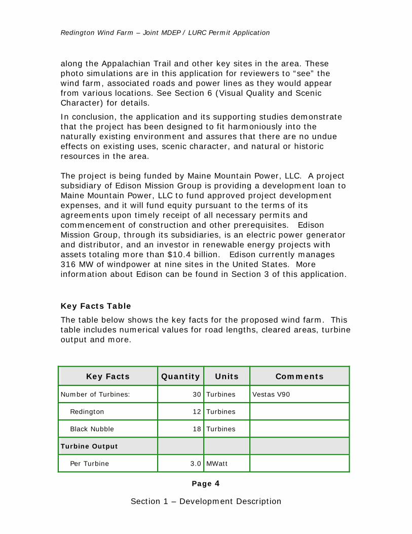
Key Facts Table
The table below shows the key facts for the proposed wind farm. This table includes numerical values for road lengths, cleared areas, turbine output and more.
Key Facts Quantity Units Comments
Number of Turbines: 30 Turbines Vestas V90
Redington 12 Turbines
Black Nubble 18 Turbines
Turbine Output
Per Turbine 3.0 MWatt
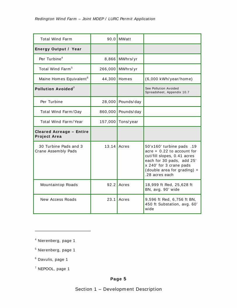
Redington Wind Farm – Joint MDEP / LURC Permit Application
Page 5
Section 1 – Development Description
Total Wind Farm 90.0 MWatt
Energy Output / Year
Per Turbine4 8,866 MWhrs/yr
Total Wind Farm5 266,000 MWhrs/yr
Maine Homes Equivalent6 44,300 Homes (6,000 kWh/year/home)
Pollution Avoided7 See Pollution Avoided Spreadsheet, Appendix 10.7
Per Turbine 28,000 Pounds/day
Total Wind Farm/Day 860,000 Pounds/day
Total Wind Farm/Year 157,000 Tons/year
Cleared Acreage – Entire Project Area
30 Turbine Pads and 3 Crane Assembly Pads
13.14 Acres 50’x160’ turbine pads .19 acre + 0.22 to account for cut/fill slopes, 0.41 acres each for 30 pads, add 25’ x 240’ for 3 crane pads (double area for grading) = .28 acres each
Mountaintop Roads 92.2 Acres 18,999 ft Red, 25,628 ft BN, avg. 90’ wide
New Access Roads 23.1 Acres 9,596 ft Red, 6,756 ft BN, 450 ft Substation, avg. 60’ wide
4 Nierenberg, page 1
5 Nierenberg, page 1
6 Davulis, page 1
7 NEPOOL, page 1
Redington Wind Farm – Joint MDEP / LURC Permit Application
Page 6
Section 1 – Development Description
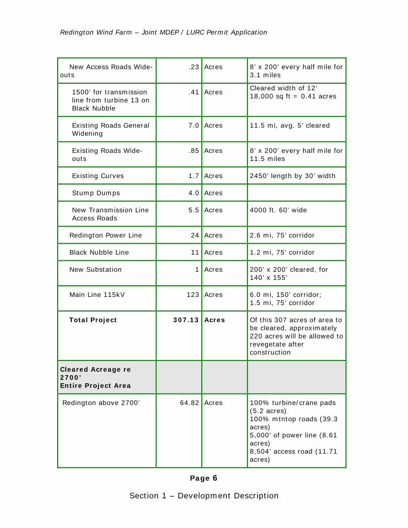
New Access Roads Wide-outs
.23 Acres 8’ x 200’ every half mile for 3.1 miles
1500’ for transmission line from turbine 13 on Black Nubble
.41 Acres Cleared width of 12’ 18,000 sq ft = 0.41 acres
Existing Roads General Widening
7.0 Acres 11.5 mi, avg. 5’ cleared
Existing Roads Wide-outs
.85 Acres 8’ x 200’ every half mile for 11.5 miles
Existing Curves 1.7 Acres 2450’ length by 30’ width
Stump Dumps 4.0 Acres
New Transmission Line Access Roads
5.5 Acres 4000 ft. 60’ wide
Redington Power Line 24 Acres 2.6 mi, 75’ corridor
Black Nubble Line 11 Acres 1.2 mi, 75’ corridor
New Substation 1 Acres 200’ x 200’ cleared, for 140’ x 155’
Main Line 115kV 123 Acres 6.0 mi, 150’ corridor; 1.5 mi, 75’ corridor
Total Project 307.13 Acres Of this 307 acres of area to be cleared, approximately 220 acres will be allowed to revegetate after construction
Cleared Acreage re 2700’ Entire Project Area
Redington above 2700’ 64.82 Acres 100% turbine/crane pads (5.2 acres) 100% mtntop roads (39.3 acres) 5,000’ of power line (8.61 acres) 8,504’ access road (11.71 acres)
Redington Wind Farm – Joint MDEP / LURC Permit Application
Page 7
Section 1 – Development Description
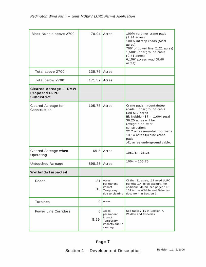
Black Nubble above 2700’ 70.94 Acres 100% turbine/ crane pads (7.94 acres) 100% mtntop roads (52.9 acres) 700’ of power line (1.21 acres) 1,500’ underground cable (0.41 acres) 6,156’ access road (8.48 acres)
Total above 2700’ 135.76 Acres
Total below 2700’ 171.37 Acres
Cleared Acreage – RMW Proposed D-PD Subdistrict
Cleared Acreage for Construction
105.75 Acres Crane pads, mountaintop roads, underground cable Red 517 acres Bk Nubble 487 = 1,004 total 36.25 acres will be revegetated after construction: 22.7 acres mountaintop roads 13.14 acres turbine crane pads .41 acres underground cable.
Cleared Acreage when Operating
69.5 Acres 105.75 – 36.25
Untouched Acreage 898.25 Acres 1004 – 105.75
Wetlands Impacted:
Roads .31
.13
Acres permanent impact Temporary due to clearing
Of the .31 acres, .17 need LURC permit; .14 acres exempt. For additional detail, see pages 103-104 in the Wildlife and Fisheries document in Section 7.
Turbines 0 Acres
Power Line Corridors 0
8.99
Acres permanent impact Temporary impacts due to clearing
See table 7-15 in Section 7, Wildlife and Fisheries
Revision 1.1 2/1/06
Redington Wind Farm – Joint MDEP / LURC Permit Application
Page 8
Section 1 – Development Description
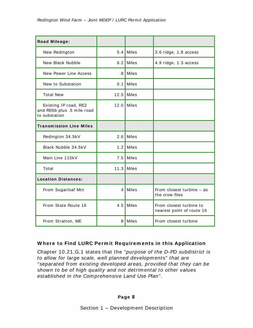
Road Mileage:
New Redington 5.4 Miles 3.6 ridge, 1.8 access
New Black Nubble 6.2 Miles 4.9 ridge, 1.3 access
New Power Line Access .8 Miles
New to Substation 0.1 Miles
Total New 12.5 Miles
Existing IP road, RE2 and RE6b plus .5 mile road to substation
12.0 Miles
Transmission Line Miles
Redington 34.5kV 2.6 Miles
Black Nubble 34.5kV 1.2 Miles
Main Line 115kV 7.5 Miles
Total 11.3 Miles
Location Distances:
From Sugarloaf Mtn 4 Miles From closest turbine – as the crow flies
From State Route 16 4.5 Miles From closest turbine to nearest point of route 16
From Stratton, ME 8 Miles From closest turbine
Where to Find LURC Permit Requirements in this Application
Chapter 10,21,G,1 states that the “purpose of the D-PD subdistrict is to allow for large scale, well planned developments” that are “separated from existing developed areas, provided that they can be shown to be of high quality and not detrimental to other values established in the Comprehensive Land Use Plan”.
Redington Wind Farm – Joint MDEP / LURC Permit Application
Page 9
Section 1 – Development Description
See Item 9 under Criteria for a Preliminary Development Plan (page 40 in this document). Also, refer to Criteria for Approval of a Preliminary Development Plan on page 30 in this document.
Chapter 10,21,G,1 further states these developments “depend on a particular natural feature or location which is available at the proposed site”.
The project’s natural feature, a first-class wind resource is described on page 35 in this document, “Utilizes the Best Reasonably Available Site”.
Chapter 10.21,G,2 – Subdistrict should include “at least 50 contiguous acres”.
See item 10 under Criteria for Approval of a Preliminary Development Plan (page 40) in this document. In addition, the Project Base Map in Appendix 1.0 of this section clearly delineates the acreage of the wind farm.
Chapter 10.21,G,2 – “No development other than access roads and utility lines shall be less than 400’ from any property line. Furthermore, the project shall be reasonably self-contained and self-sufficient and to the extent practicable provide for its own water and sewage services, road maintenance, fire protection, solid waste disposal and police security”.
See items 11 and 12 under Criteria for Approval of a Preliminary Development Plan (beginning on page 40) in this document.
Chapter 10.21,G,3 – Permitted Uses
A concept plan describing uses allowed without a permit, without a permit subject to standards and with a permit begins on page 43 of this document.
Chapter 10.21,G,8,a – “Evidence that the proposal conforms with the Commission’s Comprehensive Land Use Plan”.
See page 30 in this document for text titled “Conforms with the Comprehensive Land Use Plan”.
Chapter 10.21,G,8,a,(1) – Legal description of the property boundaries
Redington Wind Farm – Joint MDEP / LURC Permit Application
Page 10
Section 1 – Development Description
See Section 2, Land, Title and Easements in this permit application.
Chapter 10.21,G,8,a,(2) – Statement of “objectives to be achieved by locating the development in its proposed location” and “why the site is the best reasonably available for the proposed use(s)”.
The project’s objectives are stated on page 15 of this document. In addition, this document describes the demonstrated need, benefits and how the project fits harmoniously into the environment beginning on page 15. Refer to page 35 in this document, “Utilizes the Best Reasonably Available Site”, for details on site selection.
Chapter 10.21,G,8,a,(3) – “A reasonably complete development schedule and construction program”.
See the construction plan on page 63 of this document.
Chapter 10.21,G,8,a,(4) – “Statement of the applicant’s intentions with regard to future selling, leasing or subdividing portions of the project”.
See Section 2, Land, Title and Easements in this permit application.
Chapter 10.21,G,8,a,(5) – Statements that the “project is realistic, can be financed and completed”.
See Section 3, Financial Capacity, in this permit application. In addition, Section 4, Technical Ability, describes the expert consultants commissioned to develop the project’s design.
Chapter 10.21,G,8,a,(6) – Statement of “environmental impact of the proposed development which sets forth the reasonably foreseeable adverse effects and measures to be taken to minimize such effects”.
Several sections of this application deal with environmental issues: Section 5, Sound Section 6, Visual Quality and Scenic Character Section 7, Wildlife and Fisheries Section 8, Historic Sites Section 9, Unusual Natural Areas
Redington Wind Farm – Joint MDEP / LURC Permit Application
Page 11
Section 1 – Development Description
Section 15, Groundwater Section 17, Wastewater Disposal Section 19, Flooding Section 20, Blasting Section 21, Air Emissions Section 22, Odors Section 23, Water Vapor Section 24, Sunlight
Chapter 10.21,G,8,a,(7) – “A general statement that indicates how the natural resources of the area will be managed and protected so as to reasonably assure that those resources currently designated within protection subdistricts will receive protection that is substantially equivalent to that under the original subdistrict designation”.
Several sections of this application deal with natural resources: Section 5, Sound Section 6, Visual Quality and Scenic Character Section 7, Wildlife and Fisheries Section 8, Historic Sites Section 9, Unusual Natural Areas Section 10, Buffers Section 13, Maintenance Section 15, Groundwater Section 17, Wastewater Disposal Section 19, Flooding Section 20, Blasting Section 21, Air Emissions Section 22, Odors Section 23, Water Vapor Section 24, Sunlight
Chapter 10.21,G,8,a,(8) – A location map (Commission Land Use Guidance Map) that “indicates the area for which a D-PD subdistrict designation is sought. This map should show all existing subdistricts”.
See appendix 1.1 at the end of this section for LURC Land Use Guidance Maps.
Chapter 10.21,G,8,a,(9) – “A map showing existing site conditions including contours at 10 foot intervals, water courses, unique natural conditions, forest cover, swamps, lakes, ponds, existing buildings, road boundaries, property lines and names of adjoining property
Redington Wind Farm – Joint MDEP / LURC Permit Application
Page 12
Section 1 – Development Description
owners, scenic locations and other prominent topographical or environmental features”.
See appendix 1.0 at the end of this section for Project Base Map. Due to the size of the project area, RMW reached an agreement with DEP and LURC staff to display the base map at 20’ contour intervals.
Many detail maps and drawings are available. Refer to the text on design drawings on page 65 of this document.
Chapter 10.21,G,8,a,(10) – “A soils map of at least medium intensity that covers those portions of the site where any development is proposed. The description should use the soil group designation utilized in the Subsurface Waste Water Disposal Rules or the USDA Soil Series names.”
See Section 11 on Soils and Section 17 on Wastewater disposal.
Chapter 10.21,G,8,a,(11) – “A site plan that shows the approximate location and size of all existing proposed buildings, structures and other improvements, including roads, bridges, beaches, dumps, wells, sewage disposal facilities, storm drainage, cut and fill operations… …parking areas, service and loading areas.”
See appendix 1.0 at the end of this section for Project Base Map. Road, bridge and turbine foundation construction plans are located in the appendices at the end of this section. Stormwater Management is described in Section 12. Erosion and Sedimentation Control is in Section 14. A site plan for the Maintenance Facility is available in Section 13.
Chapter 10.21,G,8,a,(12) – “A map or description of the approximate type, size and location of proposed utility systems including waste disposal, water supply and electric and telephone lines”.
See appendix 1.0 at the end of this section for Project Base Map. Also see appendix 5 at the end of this document for a description of the electrical system and various electrical drawings. Refer to Section 16 for Water Supply and Section 18, Solid Waste.
Redington Wind Farm – Joint MDEP / LURC Permit Application
Page 13
Section 1 – Development Description
Chapter 10.21,G,8,b – Criteria for the Approval of a Preliminary Development Plan.
The eight required criteria listed in this portion of Chapter 10 are clearly addressed in this document as items one through eight on page 30.
Chapter 10.21,G,10,a,(2)(a) – Drawings that include all the information required on the preliminary site plan “plus the dimensions and heights, foundation design, material specifications, and elevations and colors of all building and structures”.
Refer to requirement for Chapter 10.21,G,8,a,(11) above. All drawings and exhibits give specifics on dimensions, heights, foundation design.
Chapter 10.21,G,10,a,(2)(b) – “Drawings that illustrate all roads, parking service and traffic circulation areas. The dimension of curve radii, grades and number of parking spaces are to be specified”. Bridges “should be shown as scaled engineering plans and sections.”
Refer to Appendices 2.0 and 4.0 at the end of this section for road design and bridge design. The project base map shows turning points at the top of the mountain. Parking is available at the Maintenance Center, shown in Maintenance, Section 13 of this application.
Chapter 10.21,G,10,a,(2)(c) – “If individual sewage disposal system is proposed, an on-site soil report for each proposed lot is required.”
See Section 17, Wastewater Disposal.
Chapter 10.21,G,10,a,(2)(d) – “Drawings that indicate all surface water runoff and storm drainage systems, soil stabilization procedures, and landscape plans for planting, screening, revegetation and erosion control and lighting of outdoor spaces.”
See Section 12, Stormwater Management and Section 14, Erosion and Sedimentation Control. RMW’s proposal for lighting the wind turbines, subject to FAA approval, is on page 49 in this section.
Chapter 10.21,G,10,a,(2)(e) – “To the extent reasonably available, copies of the restrictions, covenants, conditions, and/or contractual
Redington Wind Farm – Joint MDEP / LURC Permit Application
Page 14
Section 1 – Development Description
agreements that will be imposed upon persons buying, leasing, using, maintaining, or operating land or facilities within the Planned Development”.
Refer to Section 2, Land, Title and Easements, for legal agreements and Section 13 for Property Maintenance.
Where to Find DEP Permit Requirements in this Application
Upon passage of LD1588 in June 2005, DEP jurisdiction was narrowed to approximately four miles of utility line in Carrabassett Valley. Therefore, only the following sections of the application require review from this agency.
Section 0 – DEP Application Forms Section 1 – Development Description
Overview and mapping, specifically the project base map and Appendix 5, Electrical System
Section 2 – Land, Title and Easements
Plum Creek lease agreement for right-of-way in Carrabassett Valley and Maine Department of Transportation Location Permit issued to Central Maine Power along route 27.
Section 7 – Wildlife and Fisheries
Pertaining to the utility line in Carrabassett Valley
Section 12 – Stormwater Section 13 – Maintenance
Pertaining to the utility line in DEP jurisdiction Section 14 – Erosion and Sedimentation Control
Transmission line section only Section 25 – Notices of DEP required meetings.
Redington Wind Farm – Joint MDEP / LURC Permit Application
Page 15
Section 1 – Development Description
Objectives
Broad development objectives for the Redington Wind Farm project are three-fold:
1) To provide a clean, renewable source of electricity to the local area, the state of Maine and the New England region in an economically and environmentally sustainable manner;
2) To maximize local and regional benefits from the wind farm, including competitive energy on a long-term, fixed-price basis, increased Franklin County tax revenue, Maine construction jobs, and long-term local employment in wind farm maintenance and operations;
3) To ensure that the wind farm has no undue adverse effect on the wildlife and working forests where it is sited or to the area’s scenic viewshed.
The Redington Wind Farm will provide significant renewable energy, help stabilize energy prices, reduce Maine’s dependence on oil and gas, provide an economic stimulus, reduce pollution, and support Maine energy policy objectives. Details on how RMW will meet these objectives are described in the Demonstrated Need section below.
Demonstrated Need, Benefits and No Undue Adverse Effect
The Redington Wind Farm will help Maine’s economy become more economically and environmentally sustainable. It will generate enough clean, renewable energy to power more than 44,000 Maine homes, will promote economic development, will reduce pollution and greenhouse gases, and will help reduce our dependence on imported fossil fuels.
Significant Renewable Energy
The latest calculations show that Redington Wind Farm, on average, will produce over 250,000,000 kilowatt-hours (kWh) a year. This is about 2.2% of Maine’s total consumption of about 12 billion kWh a
1. Development Objectives, Purpose of D-PD and Need
Redington Wind Farm – Joint MDEP / LURC Permit Application
Page 16
Section 1 – Development Description
year8. Since the average Maine residential customer uses about 6,0009 kWh a year, the wind farm will produce enough power for over 44,000 homes. Based on data provided by Natural Resources Council of Maine on hydroelectric power production, the Redington Wind Farm will produce more power than 98 out of Maine’s roughly 100 hydroelectric dams. The NRCM spreadsheet is available as Appendix 10.6, Natural Resources Council of Maine data.
Stable Electricity Prices for Customers
In the past several years, natural gas prices have been volatile and increasing. Power prices have followed suit. RMW is negotiating with a power marketer who will resell the wind farm’s electrical output to industrial and commercial customers. The power marketer will take output from the wind farm and will secure the transmission path for the power. There are known congestion issues at the Maine/New Hampshire border at certain times. The PUC Executive Summary of their Maine Wind Energy Act study states, “there are sufficient markets available to wind power facilities developed in Maine”. The entire text of the executive summary is available in Appendix 10.8 of this section.
It is the power marketer’s responsibility to get the power to any out-of-state customers. To provide maximum benefit to Maine consumers, RMW’s power marketer will offer contracts to Maine customers, beginning with those geographically closest to the wind farm, before offering remaining power, if any, out of state.
RMW will supply evidence of a contract to LURC as a condition of pre-construction.
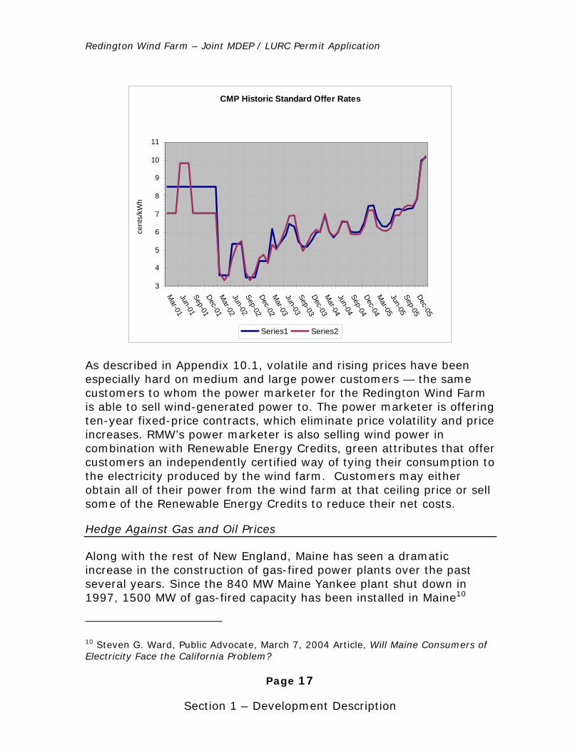
The graph below shows Central Maine Power (CMP) standard offer prices for commercial and industrial customers from 2001 to 2005.
8 ISO-NE’s 2004 Annual Markets Report, p. 15.
9 Davulis,- page 1.
Redington Wind Farm – Joint MDEP / LURC Permit Application
Page 17
Section 1 – Development Description
CMP Historic Standard Offer Rates
3
4
5
6
7
8
9
10
11
Mar-01
Jun-01Sep-01Dec-01M
ar-02Jun-02Sep-02Dec-02M
ar-03Jun-03Sep-03Dec-03M
ar-04Jun-04Sep-04Dec-04M
ar-05Jun-05Sep-05Dec-05
cent
s/kW
h
Series1 Series2
As described in Appendix 10.1, volatile and rising prices have been especially hard on medium and large power customers — the same customers to whom the power marketer for the Redington Wind Farm is able to sell wind-generated power to. The power marketer is offering ten-year fixed-price contracts, which eliminate price volatility and price increases. RMW’s power marketer is also selling wind power in combination with Renewable Energy Credits, green attributes that offer customers an independently certified way of tying their consumption to the electricity produced by the wind farm. Customers may either obtain all of their power from the wind farm at that ceiling price or sell some of the Renewable Energy Credits to reduce their net costs.
Hedge Against Gas and Oil Prices
Along with the rest of New England, Maine has seen a dramatic increase in the construction of gas-fired power plants over the past several years. Since the 840 MW Maine Yankee plant shut down in 1997, 1500 MW of gas-fired capacity has been installed in Maine10
10 Steven G. Ward, Public Advocate, March 7, 2004 Article, Will Maine Consumers of Electricity Face the California Problem?
Redington Wind Farm – Joint MDEP / LURC Permit Application
Page 18
Section 1 – Development Description
alone and much more than that throughout the region. The region has reached the point where this has not only caused price volatility and broad price increases but serious concerns about supply interruptions as well. For more information, refer to Appendix 10.3 at the end of this section for a U.S. Department of Energy white paper on natural gas dependence in New England.
Transmission and Interconnect Studies
The ability to connect to the electricity grid with limited capacity is critical to a wind energy project. The Redington Wind Farm project has devoted years to acquiring these two key assets: a queue position and a completed study.
The transmission of energy is regulated by federal and regional agencies. The Federal Energy Regulatory Commission (FERC) implements energy laws passed by Congress by promulgating regulations to be used by state and regional energy regulators. The New England Power Pool (NEPOOL) was created in 1971, integrating the majority of New England’s investor-owned and municipal systems, in order to establish a central dispatch system to enhance the region’s overall system reliability and reduce production costs. In 1996, the Federal Energy Regulatory Commission (FERC) restructured its regulatory approach to the industry, which changed NEPOOL’s role and led to the creation of ISO New England.
On July 1, 1997, ISO New England assumed control of the bulk power system in New England and, on May 1, 1999, began operating the initial NEPOOL wholesale electricity market. ISO New England Inc. is responsible for the day-to-day reliable operation of the region’s bulk electric generation and transmission system, and for administration of the region’s wholesale electricity marketplace. It is the independent system operator (ISO) of New England’s wholesale electricity supply and transmission resources. ISO New England analyzes and reports on the reliability and efficiency of proposed changes to New England’s transmission system following FERC’s requirements.
With stakeholder input and analytical assistance from the transmission owners, ISO New England analyzes and plans for the reliability and adequacy of the New England bulk power system as an integrated whole. This ensures that system improvements, including newly interconnected generating units, do not have an adverse impact on the system.

Redington Wind Farm – Joint MDEP / LURC Permit Application
Page 19
Section 1 – Development Description
To add a new source of generation to the New England power grid, various electrical studies are initiated to ensure reliability and stability for the proposed interconnection. To oversee the movement or transfer of energy into, out of or through the New England area, ISO-NE maintains a queue of approved energy projects for the region.
Obtaining a slot in that queue involves a lengthy application and testing process with ISO-NE and Central Maine Power, which owns and maintains power lines and related equipment in Maine. To receive a queue position to interconnect with the transmission grid at the Bigelow substation, RMW worked closely with both ISO-NE and CMP to follow the legal process, which generally takes a number of years to complete. RMW is well into the System Impact Study Phase of this process and has a queue position with ISO-NE for the 90MW wind farm at the Redington site. In addition, ISO-NE approved CMP’s Steady State Analysis portion of the System Impact Study. The Stability portion of the System Impact Study is expected to get ISO-NE approval in March 2006. The entire CMP report (Steady State and Stability) is available for review in Appendix 5.4.
Ongoing Economic Sustainability
Over the long run, wind and hydroelectric installations promise to produce the lowest-cost power for Maine. Currently, hydroelectric power from old dams is the least expensive of all sources. Key factors in the low cost of hydro power are that capital costs of the dams were paid down years ago; that the source of energy, water, is abundant, predictable, and endless; and that operating and maintenance costs are low. Some dams in Maine have been producing power for over 100 years.
A productive wind farm follows a similar scenario. Operating and maintenance costs are slightly higher than large dams, but still far lower than any thermal plant. Wind also uses an endless, predictable, and in Redington Wind Farm’s case, abundant natural source of kinetic energy to turn a generator directly. In contrast to thermal plants, wind generation does not require converting chemical (or nuclear) energy first to heat, then to mechanical energy — which eliminates added costs and risks associated with fuel extraction, transportation and handling, combustion equipment, boilers, pollution control, waste disposal, etc.
Wind energy, like hydro, can be produced forever at a consistently low cost with no pollution. It meets the needs of current generations
Revision 1.1 2/1/06
Redington Wind Farm – Joint MDEP / LURC Permit Application
Page 20
Section 1 – Development Description
without burdening future generations, the basic definition of economic sustainability.
In response to economic considerations as well as wildlife concerns, some Maine dams are being decommissioned and removed, not refurbished. The Redington Wind Farm represents a brand-new source of long-term electricity at an attractive cost for Maine citizens.
Supports Maine’s Renewable Energy Policy
There is little disagreement among state policymakers that the addition of wind power to Maine’s generation mix would be a positive thing. While debates continue over what tool to use to encourage wind energy development and what sites are best, key state leaders – from Governor Baldacci to the Legislature to state energy czar Beth Nagusky – are clear that Maine would benefit from the development of grid-scale wind power.
The Baldacci Administration has strongly stated its support for wind energy. In a recent Bangor Daily News op-ed11, Nagusky wrote that the Administration is “working with many developers on projects to produce renewable power and renewable fuels from Maine's vast wind and biomass resources. The governor would like to do more. He has proposed increasing the amount of renewable power, especially wind power, in Maine's electricity supply portfolio.” This refers to the Governor’s bill, An Act To Promote Economic Development in the State by Encouraging the Production of Electricity from Renewable and Indigenous Resources (L.D. 1929), considered by the Legislature in 2004, that would have created new financial incentives for the development of wind power facilities.
As amended and enacted by the Legislature, L.D. 1929 added a new chapter, entitled The Maine Wind Energy Act, to Maine’s statutes12. It includes findings that begin:
11 “Maine on Right Energy Course”, Bangor Daily News, August 30, 2005.
12 35-A MRSA c. 34
Redington Wind Farm – Joint MDEP / LURC Permit Application
Page 21
Section 1 – Development Description
The Legislature finds that it is the public interest to explore opportunities for and encourage the development, where appropriate, of wind energy production in the State in a manner that is consistent with high environmental standards and that achieves reliable, cost-effective, sustainable energy production on those sites in the State that will attract investment and permit the development of viable wind energy projects.
Another part of that bill directed the Maine Public Utilities Committee to undertake a study of wind power. The study concluded, “that there is substantial potential for the development of wind power facilities throughout the State… and that there are sufficient markets available to wind power facilities developed in Maine.” Further portions of that study’s executive summary are available in Appendix 10.8 at the end of this section.
In the 2005 legislative session, three bills were introduced to encourage new development of wind power, which resulted in the creation of the Renewable Resources Stakeholder Group. This ongoing process is examining renewable generation in Maine and what mechanisms are appropriate for encouraging new, cost-competitive renewable generation, including wind. Its report is expected by the end of the year.
It is important to note that these recent efforts seek to build on existing state, regional, and federal policies that were designed to encourage the development of wind power (and other renewables). Maine has a renewable portfolio standard (RPS) that requires that 30% of the state’s electricity be generated by renewable or efficient resources. Elsewhere in New England, Massachusetts, Connecticut, and Rhode Island all have RPSs. Wind is an eligible resource for all of these states’ RPSs. The purpose of each RPS is to create a market for wind and other renewables, and they can be very powerful incentives for wind development. Additionally, for over a decade the U.S. Congress has provided a production tax credit (PTC) for wind energy that is a critical component to project financing. The most recent extension of the PTC was in this summer’s Energy Bill. It has long been a popular provision, with support from both political parties in Congress and in the White House (including the current occupant).
Many of the reasons for these policies are obvious: wind power is clean and renewable, it provides jobs and tax revenue, and it makes our generation mix more diverse and less dependent on fossil fuels from foreign countries. One additional benefit of new wind development in
Redington Wind Farm – Joint MDEP / LURC Permit Application
Page 22
Section 1 – Development Description
New England is less known. Unless steps are taken to build more generation, New England will be facing electricity reliability problems in the near future. According to the region’s Independent System Operator, New England is 2-4 years away from a shortage of electricity13. To be clear, wind can’t solve this problem on its own, but every new generation facility in New England is important.
In addition to policies that specifically support wind energy, there are a number of other important state priorities that new wind facilities can help advance. Maine was the first state in the nation to adopt a greenhouse gas law, recognizing the detrimental effects of greenhouse gases. The statute (PL 2003, C. 237) directed that a plan be developed to enable the state to meet the reduction goals set for 2010, 2020, and over the longer term.
This legislation requires the Department of Environmental Protection to recommend how Maine can lower emissions to reduce global warming by requiring the development of a climate change action plan by July 2004 that reduces carbon dioxide emissions to 1990 levels by 2010, 10 percent below 1990 levels by 2020 and by 75 to 80 percent over the long term.
In 2004, the Maine Department of Environmental Protection completed a yearlong process culminating in a Climate Action Plan for Maine. The ultimate goal is to reduce greenhouse gases enough to avert the longer-term impacts of global warming. By producing a large amount of energy with no emissions, the Redington Wind Farm can make a significant contribution to this state goal. When operational, it will provide renewable, zero-emission electricity for Mainers.
The Maine State Energy Program created a “Clean Energy Maine” program to encourage individuals and businesses to purchase “green” energy. Beneath key program objectives (bulleted below) is a description of RMW’s contribution to that goal.
• “Helps make Maine a healthier place to live, work, vacation, and raise a family.”
13 “Regional System Plan 2005: Executive Summary”, ISO New England
Redington Wind Farm – Joint MDEP / LURC Permit Application
Page 23
Section 1 – Development Description
When built, the Redington Wind Farm will generate 265 million kilowatt hours of electricity, enough clean, renewable energy to provide electricity for more than 44,000 homes. To ensure that Maine remains “the way life should be” Redington power will prevent more than 860,000 pounds of air pollution per day from being released by existing power plants in all of New England.
• “Helps reduce dependence on foreign sources of energy and free our country from the stranglehold that comes from dependence on Middle Eastern oil.”
As wind turbine technology has improved over the past twenty years, generation costs have steadily decreased. Today, wind energy is competitively priced, a lower cost choice than energy from many gas-fired plants. As the fossil fuel supply shrinks and market demand drives prices up, wind is an attractive source of energy14.
Jobs, Taxes, and Access
The wind farm is expected to create upwards of one hundred (100) design, engineering and construction jobs during the implementation phase of the project and five to ten permanent jobs. RMW intends to contract with local firms wherever possible for constructing power lines, roads and bridges. For a discussion on job creation and economic impacts of a 24 MW wind farm project in rural Oregon, see Appendix 10.2, a study of the Klondike Wind Project.
RMW expects to pay over $500,000 a year in property taxes — a significant portion of which will stay in Franklin County. Access roads to the perimeter of the wind farm will be open except during mud season, when timber companies normally close their gates.
RMW expects to leave the top of the mountain open to nonmotorized travel unless there are circumstances that present a risk to public
14 Wind Energy Update, National Renewable Energy Lab, January 2005
Redington Wind Farm – Joint MDEP / LURC Permit Application
Page 24
Section 1 – Development Description
safety. In addition, mountain access roads and power lines will generally be gated or fenced during the winter.
Environmental Benefits
The Redington Wind Farm will prevent more than 860,000 pounds of pollutants per day from being released into the air by existing New England power plants, the equivalent of removing 26,000 cars from our roads permanently. Using another yardstick for environmental benefit, an oil-burning power plant would consume 50,000 gallons of oil per day to produce the same amount of power as the Redington Wind Farm15. Refer to RMW’s Pollution Avoided Spreadsheet in Appendix 10.7 for background on calculating these benefits.
Although Maine on its own generates a higher proportion of power from renewable sources than many states, it still bears the economic and environmental costs and risks of being home to several gas-fired and one large oil-fired power plant. (Coal is also burned in a Rumford plant.) These fossil plants have a capacity of more than 2,000 megawatts. In 2004 renewable resources (refuse, biomass, and hydro generators) generated about 8.5% of total New England electricity. Therefore New England obtained more than 90% of its power from fossil and nuclear sources16.
No Undue Adverse Effect, Fitting Harmoniously into the Environment
Redington and Black Nubble mountains are infrequently visited areas. Currently, there is one hiking trail, cut and maintained by RMW for meteorological tower maintenance that accesses the Redington summit and then traverses Redington Pond Range. “Peak baggers,” hikers who scale New England’s highest mountains, use this trail. RMW has also cut trails on Black Nubble for meteorological tower access, but few if any hikers use it, since this mountain is not as high. In ten years of field work, RMW personnel have never seen hunters on the mountaintops. After construction, nonmotorized traffic (hikers,
15 NEPOOL, page 1.
16 ISO-NE’s 2004 Annual Markets Report, p. 24.
Redington Wind Farm – Joint MDEP / LURC Permit Application
Page 25
Section 1 – Development Description
mountain bikers, backcountry skiers) will have continued and much easier access to the summits. Although ATV and snowmobile riders will have a few miles of new road to travel that will afford them views of the wind turbines and nearby countryside, they will be restricted from the mountaintops.
The Redington Wind Farm has been designed to fit harmoniously into the existing natural environment. Care has been taken to ensure that the turbines, new roads and power lines will have the least possible impact on the environment and viewshed. The wind farm will not add any pollution to its surroundings. Plants, wetlands and wildlife have been studied extensively to ensure that there is minimal or no undue adverse impact. Hikers, bikers, skiers, snowmobilers, and others will still enjoy the area’s extraordinary beauty.
For people hiking the Appalachian National Scenic Trail (AT) between Sugarloaf Mountain and the Bigelow Range (a distance of 35± miles), the wind farm will be visible for approximately 3 miles of open vistas (e.g., the top of Saddleback) and another 2-3 miles of intermittent views. The AT is closest to the wind farm on South Crocker Mountain. At that point the trail is 1 mile away from the turbines on Mount Redington; however, the summit is wooded and there are no direct views. From the summit of Saddleback Mountain hikers will be able to see most of the wind farm. The nearest turbines at that point will be 5.8 miles away. At that distance they will be visible, but their appearance will be diminished by the effects of distance. (For reference purposes, the turbines from Saddleback will seem to be as tall as an object 1/3 inch in height held at arms length.) Extensive analysis was done to develop a facility that would have minimal visual impact on the AT. During the planning process the design team evaluated a number of options before selecting the locations for the access routes and the transmission line to minimize their visibility from the trail. Intercept surveys over three years have demonstrated support for the project from hikers, especially if they understand the benefits from wind power. Many people consider wind turbines to be highly aesthetic forms of energy production and are likely to be drawn to the area and the AT to observe the wind farm in action.
Redington Wind Farm – Joint MDEP / LURC Permit Application
Page 26
Section 1 – Development Description
Outreach Activities
RMW has made particular efforts to inform leaders of the local political and business communities, interested citizens, educators, and leaders of trail, outdoor recreation, and environmental organizations about the project and to provide them with complete and factual information on the environmental and economic benefits of the project. Outreach efforts over the past three years include:
• Presentations to town officials in Rangeley and Carrabassett Valley and to the Carrabassett Valley Planning Board;
• Visual simulations at the Rangeley town office and at the Common Ground Fair,
• Debating the merits and effects of the wind farm with a trail group representative at a conference on renewable energy sponsored by the Chewonki Foundation;
• Hosting visits to the sites of the proposed wind farm for state regulators, representatives of trail and environmental organizations, and members of the Carrabassett Valley Outing Association;
• Sponsoring a visit to the Green Mountain Power wind farm, in Searsburg, Vermont, so local community and political leaders as well as interested citizens in Rangeley and Carrabassett Valley could see first-hand a wind farm in operation;
• Presentations to members of the Rangeley Region Guides’ and Sportsmen’s Association and to the membership of the Maine Appalachian Trail Club at their annual meeting;
• Negotiations to establish a formal collaborative process with concerned environmental and trail organizations.
A collection of large visual photo simulations depicting the proposed wind farm from different viewpoints located from about one to ten miles away from the site has been part of every presentation, and copies of the same simulations have been made available to the Rangeley and Carrabassett Valley town offices for long-term display. The press has ready access to project spokesperson Harley Lee, who frequently provides general background information about wind energy to journalists and has been interviewed about the Redington project
Redington Wind Farm – Joint MDEP / LURC Permit Application
Page 27
Section 1 – Development Description
numerous times. In addition, RMW has maintained a list of individuals who are supportive of the wind farm. Names are available in Appendix 11.1 of this section.
Public Opinion Surveys and Results
RMW has commissioned local public opinion surveys to gauge support for the proposed wind farm. The effort began in 1994, when RMW worked with trail group representatives to develop questions and methodology for a survey. An independent contractor then administered the survey, which consisted of several dozen questions, to representative samples from five groups — local residents, skiers, hunters, hikers, and snowmobilers. In response to one question that asked respondents to rate how appropriate wind power was for Carrabassett Valley area while they were shown photo-simulated views of the Redington Wind Farm, 75 to 84% of locals, skiers, hunters and snowmobilers gave the project a neutral or positive rating. This level of support usually only occurs after a wind farm is up and running. Of the hikers surveyed in 1994, 51% gave the Redington Wind Farm a neutral or positive rating. A resurvey of hikers using more updated and accurate simulations was conducted in the fall of 2003. Results very closely matched results obtained earlier from the other four groups: 79% of hikers responding were supportive or neutral about the wind farm. To further validate results, the survey was given again in the summer of 2004: 75% of hikers responding — many of them through-hikers — were supportive or neutral. See Section 6 of this application (Visual Quality) for complete survey results. Also see Appendix 11.1 (Supporters Database List) and 11.2 (Hiker Support Letters).
The following section lists the existing facilities.
Redington Township Facilities
Redington Township is the proposed location for the wind turbines, mountain roads, portions of the power lines, and the maintenance center. The Redington Township area has long been part of the working forest and is crisscrossed by dozens of logging roads and skidder trails with many bridges and culverts installed over streams. Evidence of logging activities is pervasive. This area is at some
2. Existing Facilities and Uses
Redington Wind Farm – Joint MDEP / LURC Permit Application
Page 28
Section 1 – Development Description
distance from Route 27 and power lines. RMW is not aware of any private camps in Redington Township.
Ten meteorological towers have been erected since 1993 on the proposed D-PD site. Only two remain, one on Black Nubble and one on Redington. Tower parts are stored at some of the sites where wind measurements were previously taken.
U.S. Navy/SERE School
The southern half of Redington Township, owned by the U.S. Navy, is the site of a SERE (survival, evasion, resistance, escape) training center. The SERE school, which is run out of the Brunswick Naval Air Station, has a helipad and a handful of buildings as well as a mock prisoner of war camp. It is not unusual to hear machine gun fire or aircraft. The southern boundary of RMW land abuts the northern boundary of the Navy property.
Appalachian Trail
The Appalachian Trail, a scenic hiking trail, runs through the southern end of Redington Township and through Carrabassett Valley. For its exact location, refer to the Project Base Map.
Dallas Company, Stratton Maine
The Dallas Company also owns land that abuts the proposed D-PD site in Redington Township. Dallas currently manages this property for timber growth and harvesting. In addition to logging roads, the Dallas property includes several gravel pits.
Facilities for dumping stumps are noted in Section 18, Solid Waste.
Gravel pit locations are mapped in Section 11, Soils.
Existing bridges and major culverts are described in Appendix 4 at the end of this section.
Plum Creek Timber Company, Inc.
Plum Creek Timber Company, Inc., the second largest private timberland owner in the United States, owns significant amounts of
Redington Wind Farm – Joint MDEP / LURC Permit Application
Page 29
Section 1 – Development Description
forest and roads in Carrabassett Valley, adjacent to and east of the proposed D-PD site. Use of this property is for timber growth and harvesting. Plum Creek logging roads are noted on the project base map.
International Paper, Coplin Plantation
RMW will be using the IP logging road as the main access into the D-PD site for turbine delivery, construction and ongoing maintenance. This land, located in the southern half of Coplin Plantation, is working forest. There are some houses and camp lots near Route 27.
Boralex Biomass Generation Facility, Stratton, Maine
The 50 MW Stratton Energy plant is the largest of the biomass-fired independent power projects developed in Maine. The power line from the biomass plant runs through the southern end of Wyman Township and connects at CMP’s Bigelow substation. RMW’s proposed power line will run immediately adjacent to the Boralex line.
RMW proposes to create a LURC D-PD subdistrict within a previously designated P-MA subdistrict for the Redington Wind Farm project. As stated in LURC Chapter 10.21,G (D-PD), this subdistricting is “designed to encourage creative and imaginative design and site planning, to promote efficient use of the land and to afford the applicant reasonable guidance in formulating an acceptable development proposal”.
Chapter 10.21,G (D-PD) also specifies that the D-PD should be used for large scale, well planned developments that are separated from existing developed areas, that depend on a particular natural feature which is available at the proposed site, and that are high quality projects not detrimental to other values established in the Comprehensive Land Use Plan. Chapter 10 also lists requirements for real estate, access roads, utility lines, water and sewage services, road maintenance, fire protection, solid waste disposal, and security.
The next several pages provide a summary of how RMW has demonstrated that the proposed project meets the criteria for approval for a D-PD subdistrict.
3. Consistency with LURC Land Use and D-PD Zoning
Redington Wind Farm – Joint MDEP / LURC Permit Application
Page 30
Section 1 – Development Description
This summary is followed by a listing of the activities associated with the project that require a permit from LURC, a list of activities that can be done without a permit as long as LURC guidelines are followed and a listing of activities that do not require a permit.
Criteria for Approval of a Preliminary Development Plan
The LURC Comprehensive Land Use Plan allows the Commission to approve an application for permit on the basis of several criteria. Items one through eight below address criteria cited in Chapter 10.21,G,8(b). Items nine through twelve address criteria in Chapter 10.21,G,2.
1). Conforms with the Comprehensive Land Use Plan
A development plan and permit application must conform with the objectives and policies of the Comprehensive Land Use Plan and 12 M.R.S.A. ξ 206-A
The following statements appear on page 40 of Chapter 3 of the Comprehensive Land Use Plan:
“Maine’s wind resource is considerable, and much of it occurs along high mountain tops and ridges within the jurisdiction. These winds have the potential to power wind energy technologies that appear to compete with more traditional energy sources.”
“As a renewable form of energy, windpower offers an attractive alternative to the burning of fossil fuels. Large windpower installations, however, have the potential to conflict with other values…particularly those associated with mountain areas, the areas where wind power developers have focused their efforts to date.”
Respect for the forest, viewsheds, and mountain environment was the guiding principle for all development decisions for the Redington wind farm. This permit application conforms with LURC’s Goals and Policies stated in Chapter 5 of the Comprehensive Land Use Plan as outlined below:
Air Resources:
Goal: Protect the quality of air resources throughout the jurisdiction.

Redington Wind Farm – Joint MDEP / LURC Permit Application
Page 31
Section 1 – Development Description
Policy #1: Require compliance with all state and federal air quality standards. Policy #2: Encourage state initiatives directed at reducing emissions of air pollutants.
RMW’s compliance is described in Section 21, Air Emissions.
Cultural, Archaeological and Historical Resources:
Goal: Protect and enhance archaeological and historical resources of cultural significance. Policy: Identify and protect unique, rare and representative cultural resources to preserve their educational, scientific, and social values.
RMW’s compliance is described in Section 8, Historic Sites.
Energy Resources:
Goal: Provide for the environmentally sound and socially beneficial utilization of indigenous energy resources where there are not overriding, conflicting public values which require protection.
Policy #3: Permit new energy developments where their need to the people of Maine has been demonstrated and they are sited, constructed and landscaped to minimize intrusion on natural and human resources.
RMW’s compliance is discussed in the Demonstrated Need description in this Section of the Application. Visual Impact (Section 6), Wildlife & Fisheries (Section 7) and Road Design (Appendix 2.0 of this Section) describe the efforts RMW has made to minimize intrusion.
Forest Resources:
Goal: Conserve, protect and enhance the forest resources which are essential to the economy of the state as well as to the jurisdiction. Policy #2: Protect areas identified as environmentally sensitive by regulating forestry activities, timber harvesting, and construction of land management roads.
Redington Wind Farm – Joint MDEP / LURC Permit Application
Page 32
Section 1 – Development Description
Approximately 106 acres of 1004 owned acres in the proposed D-PD will be developed for the wind farm. The remaining 898 acres of forest will be preserved, as RMW has no plans to harvest timber. RMW’s compliance for road construction is described in the road design document in Appendix 2.0 of this section.
Geologic Resources:
Goal: Conserve soil and geological resources by controlling erosion and by protecting areas of significance.
Policy#2: Regulate land uses in areas with identified topographical or geological hazards, including areas with fragile soils, steep slopes, high elevations, or seismic faults.
Policy#3: Administer standards for structural development and other land uses based on soil suitability.
RMW’s compliance is addressed in Section 11, Soils.
Policy#4: Administer performance standards for timber harvesting, road construction, gravel extraction, stream crossings and other land use activities in order to control potential causes of accelerated soil erosion.
RMW’s compliance is addressed in Section 11, Soils, Section 14 on Erosion Control, and Section 20, Blasting.
Mineral Resources:
Goal: Allow environmentally responsible exploration and mining of mineral resources where there are not overriding, conflicting public values which require protection.
Policy #8: Permit larger sand and gravel extraction operations in areas zoned for industrial development where a benefit to the people of Maine has been demonstrated and the operations are sited and developed in a fashion which minimizes adverse effects on other land uses and natural resources.
Compliance with respect to gravel pit locations is addressed in Section 11 on Soils. All gravel or shale pits currently on Dallas property are less than 1 acre in size. The project will keep the pits under the 5 acre limit specified in LURC rules. Details on gravel requirements for construction are in Section 18, Solid Waste.
Mountain Resources:
Revision 1.1 2/1/06
Redington Wind Farm – Joint MDEP / LURC Permit Application
Page 33
Section 1 – Development Description
Goal: Conserve and protect the values of high mountain areas from undue adverse impacts. Policy#13: Regulate high mountain areas to preserve the natural equilibrium of vegetation, geology, slope, soil and climate, to reduce danger to public health and safety posed by unstable mountain areas, to protect water quality, to preserve scenic values, vegetative communities, and low-impact recreational opportunities.
RMW’s compliance is described in Section 1 appendices on road design and electrical system. In locating roads and power line corridors, approaches that encroached on wetlands or had higher visual impacts were discarded and alternatives with lesser impact were found. More information on visual impact is available in Section 6. Section 7 has detailed descriptions of plant life.
Recreational Resources:
Goal: Conserve and protect the natural beauty and unspoiled qualities of mountains, plant and animal habitats, forests, scenic vistas, trails and other natural and recreational features in order to protect and enhance their values for a range of public recreational uses. Policy#6: Encourage traditional outdoor recreation by working with landowners to conserve the natural resources of the jurisdiction and to enhance recreational opportunities.
RMW compliance is described in Section 6, Visual Quality and Scenic Character and Section 7, Wildlife and Fisheries. Recreational uses are described under Jobs, Taxes, and Access in the Demonstrated Need section of this document.
Special Natural Areas:
Goal: Protect and enhance identified features and areas of natural significance. Policy: Identify and protect natural areas that possess unique physical features, or which serve as habitat for rare, threatened or endangered species or representative plant communities.
RMW compliance is described in Section 7, Wildlife and Fisheries and Section 10, Buffers.
Redington Wind Farm – Joint MDEP / LURC Permit Application
Page 34
Section 1 – Development Description
Water Resources:
Goal: Preserve, protect and enhance the quality and quantity of surface and ground waters. Policy#1: Regulate uses of land and water, including wetlands, in order to prevent degradation of water quality and undue harm to natural habitats. Policy#10: Protect ground water quality throughout the jurisdiction through proper controls on potentially polluting activities.
RMW compliance on wetland protection is described in Section 7, Wildlife & Fisheries, and water quality is discussed in Section 15, Groundwater, and Section 17, Wastewater.
Wetland Resources:
Goal: Conserve and protect the aesthetic, ecological, recreational, scientific, cultural and economic values of wetland resources. Policy#4: Ensure that development projects in wetlands (in this order) avoid, minimize, restore, reduce or eliminate over time and/or compensate for functional wetland losses.
RMW compliance in avoiding wetlands is described in the Impact Assessment text in Section 7, Wildlife and Fisheries.
Wildlife and Fisheries Resources:
Goal: Conserve and protect the aesthetic, ecological, recreational, scientific, cultural and economic values of wildlife and fisheries resources. Policy #1: Regulate land use activities to protect habitats, including deer wintering areas and coastal bird nesting sites, ecosystems, food sources and other life requisites for wildlife species. Policy #2: Protect wildlife habitat in a fashion which is balanced and reasonably considers the management needs and economic constraints of landowners. Policy #3: Regulate land use activities to protect habitats for fish spawning, nursery, feeding and other life requirements for fish species.
Redington Wind Farm – Joint MDEP / LURC Permit Application
Page 35
Section 1 – Development Description
Policy #4: Encourage management of fisheries and wildlife resources to maintain their habitats, diversity, and populations.
RMW compliance to all of the above is described in Section 7, Wildlife and Fisheries.
Scenic Resources:
Goal: Protect scenic character and natural values by fitting proposed land use activities harmoniously into the natural environment and by minimizing adverse aesthetic effects on existing uses, scenic beauty, and natural and cultural resources. Policy #2: Regulate land uses generally in order to protect natural aesthetic values and prevent incompatibility of land uses. Policy #3: Protect the scenic values of mountain, recreation and other scenic areas.
RMW compliance is described in the Visual Quality and Scenic Character assessment in Section 6.
2). Incorporates Environmental / Resource Protection
Development on the proposed D-PD site must incorporate a substantially equivalent level of environmental and resource protection as was afforded under the former protected subdistrict.
The mountaintop development portion of the wind farm will be constructed on 106 of approximately 1,004 total acres of owned property. Of those 106 acres, 36 will be revegetated after construction. Comprehensive environmental studies have been performed in every area that will be affected. Areas of concern have been identified and avoided (wetlands, streams, etc.). In all altered areas, environmental studies conclude that there will be no significant long-term impacts once construction is completed.
3). Utilizes the Best Reasonably Available Site
The three most important elements necessary for a successful wind farm are a strong consistent wind resource, proximity to high-capacity power transmission lines, and good access roads. These elements are necessary to hold development costs within reasonable limits. Additionally, the developer must be able to acquire property and obtain easements, which is sometimes a significant hurdle that entails
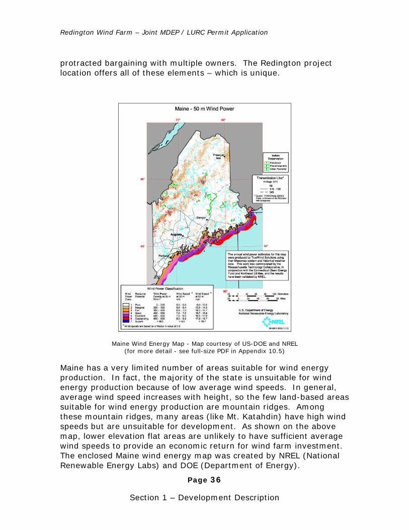
Redington Wind Farm – Joint MDEP / LURC Permit Application
Page 36
Section 1 – Development Description
protracted bargaining with multiple owners. The Redington project location offers all of these elements – which is unique.
Maine Wind Energy Map - Map courtesy of US-DOE and NREL (for more detail - see full-size PDF in Appendix 10.5)
Maine has a very limited number of areas suitable for wind energy production. In fact, the majority of the state is unsuitable for wind energy production because of low average wind speeds. In general, average wind speed increases with height, so the few land-based areas suitable for wind energy production are mountain ridges. Among these mountain ridges, many areas (like Mt. Katahdin) have high wind speeds but are unsuitable for development. As shown on the above map, lower elevation flat areas are unlikely to have sufficient average wind speeds to provide an economic return for wind farm investment. The enclosed Maine wind energy map was created by NREL (National Renewable Energy Labs) and DOE (Department of Energy).
Redington Wind Farm – Joint MDEP / LURC Permit Application
Page 37
Section 1 – Development Description
Redington Pond Range and Black Nubble Mountains are two of the few sites in Maine with extremely energetic winds. This wind resource has been scientifically confirmed with nearly ten years of wind energy measurements obtained from ten different measurement locations on both mountains. The mountains fall into the highest wind energy classes with high average wind speeds.
EEC has also confirmed the low average wind speeds in lower elevation sites. EEC has an experimental wind turbine on the coast (Orland, Maine). The average wind speeds at this location are low and energy production at this site is consequently low. EEC has also been measuring wind speeds at another site in Maine (near Waterville) that also has proven to have unsuitable average wind speeds.
Selecting sites with suitable average wind speeds is critical to the success of a wind farm. Small differences in average wind speeds can make large differences in energy output. The power available in the wind is proportional to the cube of its speed, which means that doubling the wind speed increases the available power by a factor of eight. Thus, a turbine operating at a site with an average wind speed of 20 mph could in theory generate about 800% more electricity than one at a 10 mph site, because the cube of 20 (8,000) is 800% larger than the cube of 10 (1,000). In the real world, the turbine will not produce that much more electricity because turbines are optimized for certain wind speed distributions. According to Vestas literature, a V90 will produce gross output of 3,114 MWh at an 11 mph average site and 13,301 MWh at a 22 mph site with a shape factor of 2.0. This higher wind speed site results in four times greater output. What seems like a small difference in wind speed can mean a large difference in available energy and in electricity produced, and therefore, a large difference in the cost of the electricity generated. Also, there is little energy to be harvested at very low wind speeds (6 mph winds contain less than one-eighth the energy of 12 mph winds.)
The exponential increase in production with higher wind speeds makes careful site selection critical to project success. RMW has measured wind speeds at different altitudes at many different mountain and coastal sites throughout New England. All studies confirm that the best wind resources in New England occur at higher elevations. The project site has a world-class wind resource with north-south ridgelines that are high enough to generate maximum electricity from strong prevailing westerly winds. It is situated within the working forest with
Redington Wind Farm – Joint MDEP / LURC Permit Application
Page 38
Section 1 – Development Description
access to a network of roads maintained to withstand commercial timber harvesting. The planned substation is about eight miles from a high-capacity transmission interconnect point. Finally, the property and easements necessary to construct the wind farm are in place, having been carefully acquired over the past four years.
4). Conserves Productive Forest Land
More than 898 of the 1,004 acres in the Redington and Black Nubble parcels will remain in their natural state, untouched.
Terrain at higher elevations in Maine is generally unsuitable for forest or farm cultivation. Severe weather limits the growing season for all plants, and soils are thin and nutrient-poor. Use of the mountain ridges proposed for the Redington Wind Farm will not affect any productive forest or farmland.
The wind farm will not interfere with ongoing work in the surrounding forest; instead, it makes productive use of a relatively small area of forest land that is virtually useless for commercial logging due to the poor quality of the vegetation and the steep terrain.
5). Incorporates High Quality Planning and Design
In preparation for this application, the wind farm developers have completed extensive studies to develop a detailed and complete wind farm design, prepared in partnership with a number of Maine’s most knowledgeable and respected engineering and environmental consulting firms.
6). Self-Sufficient with Regard to Public Services
RMW has reviewed fire protection and security needs for the wind farm with the Maine State Forest Service and the towns of Rangeley, Stratton, and Carrabassett. The wind farm should not cause any significantly increased demand on the affected fire and police resources.
7). Provides Safe and Efficient Traffic Circulation
Construction of the wind farm is expected to take place in phases over the course of a year. During construction there will be occasional limited periods of heavy traffic on state routes 16 and 27 to transport
Revision 1.1 2/1/06

Redington Wind Farm – Joint MDEP / LURC Permit Application
Page 39
Section 1 – Development Description
employees and equipment to and from the site. Traffic volume will be well within the existing capacity of the state highways.
On the mountains, heaviest traffic is expected during road and power line construction. This “internal” construction traffic will not interfere with any public roads or highways. Construction materials will be delivered as needed and will not cause any disruption to local traffic. Turnaround areas for construction vehicles on the mountain top roads are shown on the project base map (see Appendix 1). Parking areas are shown on the maintenance lot (see drawing in Property Maintenance Section 13).
Toward the end of the construction phase, when turbine components are being delivered, there will be a minor impact to traffic on area roads from the Waterville railhead, including local segments of routes 27 and 16. (A descriptive summary and pictures of a typical delivery can be found in Appendix 8.0 on the permitting cd).
Post-construction, when the wind farm is in operation, usual highway traffic will be limited to five to ten maintenance people traveling to the maintenance center for routine operations. Routine wind farm maintenance will occur within the site using private logging roads and the extensions connecting them to the turbine sites.
8). Reduces Pollution & Energy Consumption
Wind is the fastest growing renewable energy source in the world. It is cheap, abundant, inexhaustible, widely distributed, clean, climate-benign, fossil-fuel-independent, and geopolitically neutral. No other energy source has all of these attributes.
Wind turbines for this project are manufactured by the Danish firm Vestas, the current world leader in turbine design. They are the latest generation of multi-megawatt turbines, field-tested under different conditions at locations across the globe. Using these particular machines and technology allows the wind farm to produce more electricity with fewer turbines. Although it is beyond the purpose and reach of any wind farm to reduce energy consumption, the Redington Wind Farm will avoid releasing over 860,000 pounds of pollution from fossil-fuel generation into the northern New England atmosphere every day.
Redington Wind Farm – Joint MDEP / LURC Permit Application
Page 40
Section 1 – Development Description
9). Separate from Existing Developed Areas
The Redington Wind Farm is sited on Redington Pond Range and Black Nubble Mountain. Except for its maintenance facility, the wind farm is over four miles from the closest developed areas, private residences along Route 16 and the Sugarloaf ski area summit.
10). Greater than 50 Contiguous Acres
The proposed D-PD area is 1,004 acres. The combined cleared acreage within the D-PD for construction is approximately 106 acres. Cleared acreage for the entire project area is approximately 307 acres. Wind generation facilities are exempt from the requirement for a 30,000 square-foot minimum building floor area.
11). 400’ Minimum Distance from Property Lines
The mountaintop properties that RMW purchased for the wind farm were intentionally surveyed not just to include necessary wind-rich ridge tops, but also to cause the least possible additional impact to high mountain terrain. Where it has been necessary to locate turbines closer than 400 feet to the property boundary, there are no negative impacts to the surrounding forested terrain.
RMW has signed agreements with the Dallas Corporation and Plum Creek, two of the three neighbors of the wind farm, to locate wind turbines closer to the property boundary. These documents are available for review in Section 2, Land Title and Easements, as Black Nubble Expansion (for Dallas) and Plum Creek Option Agreement. The Navy, the third neighbor, is maintaining a neutral position on the wind farm.
RMW requests a reduction in the setback requirements for those wind turbines that are closer than 400 feet to the property line. Setbacks are listed in the chart below:
Turbine No. Distance from
Property Line to center of Turbine (ft)
Distance from Property Line to
Turbine Base (ft)
Distance from Property Line to Tip of Turbine Blade (ft)
1 342.87 336.37 195.23

Redington Wind Farm – Joint MDEP / LURC Permit Application
Page 41
Section 1 – Development Description
2 173.98 167.48 26.34
3 262.57 256.07 114.93
4 476.65 470.15 329.01
5 701.29 694.79 553.65
6 865.56 859.06 717.92
7 303.50 297.00 155.86
8 845.95 839.45 698.31
9 1183.59 1177.09 1035.95
10 694.62 688.12 546.98
11 173.00 166.50 25.36
12 767.04 760.54 619.40
13 433.33 426.83 285.69
14 422.44 415.94 274.80
15 585.90 579.40 438.26
16 528.53 522.03 380.89
17 393.03 386.53 245.39
18 625.81 619.31 478.17
19 738.90 732.40 591.26
20 765.82 759.32 618.18
21 373.56 367.06 225.92
22 399.30 392.80 251.66
23 487.33 480.83 339.69
24 453.94 447.44 306.30
25 173.54 167.04 25.90
26 173.54 167.04 25.90
Redington Wind Farm – Joint MDEP / LURC Permit Application
Page 42
Section 1 – Development Description
27 282.35 275.85 134.71
28 405.94 399.44 258.30
29 214.46 207.96 66.82
30 457.09 450.59 309.45
Radius of Turbine Base = 6.50 feet
Distance from center of turbine to blade tips (45 meters) = 147.64 feet
12). Water, Road, Fire, Security and Solid Waste
The Redington project described in this application will be self-contained and self-sufficient, as follows:
Septic
The Maintenance Center will have a drilled well and a septic system designed and installed to applicable local codes. See the wastewater permit (disposal system application) in Section 17 (Wastewater) of this application. During construction and operation, portable sanitary stations will be utilized at various locations on the project site.
Fire & Security
The towns of Stratton, Rangeley, and Carrabassett Valley will supply fire protection services for the wind farm. These towns do not officially work with unorganized townships - like Redington Township - but they do work with the Maine State Forest Service, the entity responsible for fire services in the unorganized territories. A letter from the Forest Service is included in the revisions section of the permit. The nearest fire station is located in Stratton.
For police services, the area is served by the state police and the local sheriff's department. They alternate on a weekly basis for coverage in the Redington Township area. A letter from the Franklin County Sheriff’s office is included in the revisions section of the permit.
Road improvements necessary for Redington and Black Nubble mountains will enhance emergency access to these areas. Roads and power line openings will also provide fire breaks. Fires from wind turbines are extremely rare; however, each wind turbine is equipped with a fire suppression system and is fully alarmed and monitored for fires and other unusual activity.
Revision 1.1 2/1/06
Redington Wind Farm – Joint MDEP / LURC Permit Application
Page 43
Section 1 – Development Description
Prior to construction, RMW will review the project with local fire marshals, to get their input on the fire risk associated with the turbines, the substation, and the power lines. Emergency access will be enhanced with the designation of emergency locations for helicopter rescue (life-flight) and with the installation of road signs.
During construction, private security personnel will be utilized to patrol the construction areas and equipment. After construction, security requirements at the wind turbine sites will be minimal. The turbines are locked, tamper-proof, and do not present a security risk. Turbine access roads will be gated to prevent unauthorized motor-vehicle use.
Any additional or specialized training necessary for emergency rescue related to the wind turbines will be provided by RMW (ropes training, high angle rescue).
After construction, security requirements at the wind turbine sites will be minimal. The turbines are locked, tamper-proof, and do not present a security risk. Roads will be gated at times during the winter and “mud” season to prevent road use during hazardous conditions.
Solid waste
RMW has begun discussions with local waste haulers to remove assorted construction debris. Construction debris is not expected to be significant, however, all trash services will be provided by local, private waste-hauling firms.
Solid waste disposal, a construction concern, will be addressed as defined in Section 18, Solid Waste.
Description of Activities
Uses requiring a permit
a) Level C road projects;
New gravel roads to access both mountaintops and roads connecting the turbine sites will be constructed. See the Road Design narrative (Appendix 2 at the end of this Section).
b) Water crossings of minor flowing waters;
Temporary bridges will be built as necessary to cross wet areas during construction. Existing roads currently have bridges over all major water crossings. Smaller crossings are addressed in the Road Design narrative at the end of this Section.
Redington Wind Farm – Joint MDEP / LURC Permit Application
Page 44
Section 1 – Development Description
c) Utility line construction;
An underground 34.5 kV collector system will be installed under the roadway in the proposed D-PD site on both mountains. Power line details are available in Appendix 5.0 - Electrical System.
d) Lighting on towers;
Lights will be installed on the nacelles of selected wind turbines in compliance with FAA regulations.
e) Portable toilet facilities during construction;
Several portable toilets will be located on the D-PD site during construction. After construction, toilet facilities in the maintenance center will be sufficient.
f) Filling and grading for wind turbines, roads and the underground electrical collector system;
g) Other structures requiring excavation or blasting;
The 18 turbines on Black Nubble and 12 turbines on Redington need individual foundations. Tubular-type foundations would require drilling and blasting a 30’ hole for each turbine. Each turbine will be located in a 160’ x 50’ cleared area next to the mountaintop access road. Clearing the site may require excavation or blasting. See Appendix 7 at the end of this section (Wind Turbine Foundation Details) for a description of wind turbine foundation construction.
h) Other structures;
Two types of structures will be built on the D-PD development area. The wind turbines that will produce electricity and two 80-meter tall wind measurement “reference” towers located on the westernmost part of each mountain. A reference tower provides valuable feedback on the performance of the wind farm and the turbines. It is a tool utilized to determine if the wind turbines are functioning properly and producing the correct amount of electricity.
The reference towers will be installed in two stages. Initially, taller towers would be installed for turbine verification, then reduced in height and kept as a permanent tower.
Revision 1.1 2/1/06
Redington Wind Farm – Joint MDEP / LURC Permit Application
Page 45
Section 1 – Development Description
The taller reference towers are necessary to perform turbine power curve verification checks. These initial towers are anticipated to be 80m (260’) tall. Once the wind turbine’s performance has been verified and calibrated, the taller tower will be reduced to a height of 60m (196’). The towers will be instrumented with calibrated anemometers and wind vanes to measure wind speeds and direction at multiple height levels.
Uses allowed without a permit subject to LURC standards
a) Level A road projects;
Redington Wind Farm construction will include upgrading existing primary roads, access roads and bridges to withstand heavy loads during construction and maintenance. Activities will include replacing culverts, resurfacing and repairing bridges. See the road and bridge construction documents in the appendix of this section for details.
b) Signs listed as exempt in Chapter 10.27,J;
Signs installed on the roadways will assist in directing traffic and emergency personnel. Signs warning of potential icing events will be posted at mountain road entrances.
c) Mineral exploration and extraction;
Exploratory pits and test borings will be dug or drilled to determine the composition of underlying soils for design and siting of turbine foundations and roads. Gravel requirements to generate the material needed for the surface of the roadway are described in Section 18 of this application, Solid Waste.
Uses allowed without a permit
a) Emergency operations for wind farm contractors during construction and maintenance;
Upgrading existing logging roads and constructing new roads will improve emergency access to areas within Redington Township. Emergency assistance will be provided by town fire and emergency teams from Stratton and Rangeley.
Revision 1.1 2/1/06
Revision 1.1 2/1/06
Redington Wind Farm – Joint MDEP / LURC Permit Application
Page 46
Section 1 – Development Description
b) Forest management activities by RMW;
c) Motorized vehicular traffic on roads and trails, and snowmobiling authorized by RMW;
During construction, there will be periods of employee travel and heavy equipment transport. When the wind farm is operational, typical public highway traffic will be five to ten maintenance personnel traveling to the maintenance center for routine operations. Wind farm maintenance staff will use the network of private logging roads and new extensions to the mountaintops, not public roads.
In the winter, snowmobiles or snow-cats may be the only way to access the wind farm and power lines for routine or unscheduled maintenance. Adequate parking and storage for snowmobiles and ATV’s will be available at the maintenance center.
d) Surveying and other resource analysis authorized by RMW;
Wind studies will be conducted periodically.
e) Wildlife and fisheries management ongoing;
Periodically, wildlife experts will conduct studies to ascertain impact on birds and various species. Complete wildlife analysis is documented in Section 7 of this application.
The project consists of wind turbines, lighting, road access and bridges, an electrical collection system, a 34.5kv transmission line and substation, a 115kv transmission line and a maintenance facility. Each of these components is discussed below.
4. Description of the Technical Components
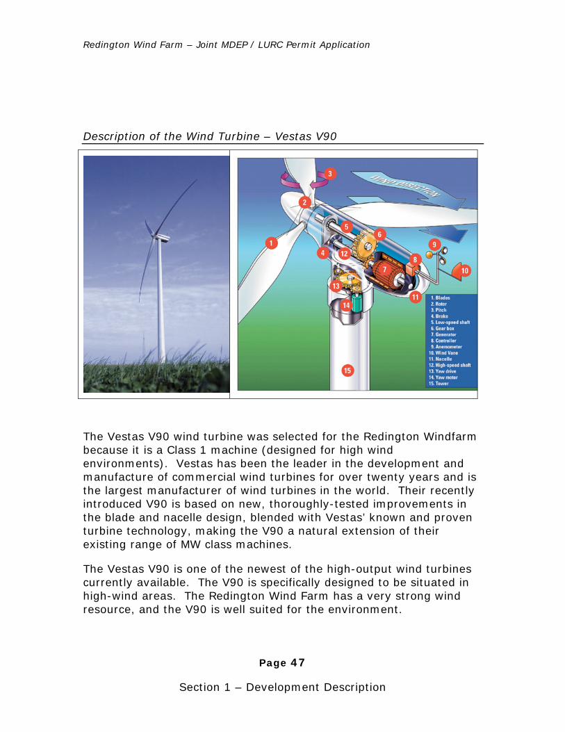
Redington Wind Farm – Joint MDEP / LURC Permit Application
Page 47
Section 1 – Development Description
Description of the Wind Turbine – Vestas V90
The Vestas V90 wind turbine was selected for the Redington Windfarm because it is a Class 1 machine (designed for high wind environments). Vestas has been the leader in the development and manufacture of commercial wind turbines for over twenty years and is the largest manufacturer of wind turbines in the world. Their recently introduced V90 is based on new, thoroughly-tested improvements in the blade and nacelle design, blended with Vestas’ known and proven turbine technology, making the V90 a natural extension of their existing range of MW class machines.
The Vestas V90 is one of the newest of the high-output wind turbines currently available. The V90 is specifically designed to be situated in high-wind areas. The Redington Wind Farm has a very strong wind resource, and the V90 is well suited for the environment.
Redington Wind Farm – Joint MDEP / LURC Permit Application
Page 48
Section 1 – Development Description
The V90 is a pitch-regulated upwind wind turbine, with active yaw control and a three-blade rotor. The turbine has a rotor diameter of 90 meters (about 300’), with a generator rated at 3.0 MW.
Facts cited are available in the detailed Vestas specifications in Appendix 6.0 – V90 General Specifications.
Towers
The wind turbine towers are fabricated from four pieces of conical tubular steel, 13 feet in diameter at the base, tapering to 7.5 feet at the top. The height of the towers will be 80 meters (263 feet). To accommodate the strong wind resource and the severe winter conditions expected at the site, RMW will utilize a class 1 tower, rated to withstand 120mph winds.
The tower external surfaces are smooth, providing no bird perches, and internally consist of 3 evenly spaced platforms, an access ladder or lift, and top-to-bottom runs of power and communications wiring. Access into the tower will be via a locked door at the base.
Nacelle
The nacelle is the housing for the generator located at the top of the tower where the blades connect to the hub. It is a heated, weather-protected steel frame and fiberglass assembly, housing the turbine’s 360 degree yaw control, main rotor bearing and blade pitch mechanism, transmission, electric generator, and control electronics. An opening in the floor provides access into the nacelle from the tower. The roof section is equipped with a skylight, which can be opened to access the wind sensors (mounted on the nacelle roof) and FAA lighting.
A cold weather package for the V90 will be used, consisting of extra sealing and heating in the nacelle, special cold-weather lubricants, and adjustments to the turbine control system to allow operation in colder temperatures.
For turbine erection, the components will first be delivered to the project’s maintenance area and pre-assembled. When the cranes are in place at the turbine site, first the tower sections, then the nacelle, and finally the blades will be driven up to the pad using specialized heavy transport vehicles. Once at the pad, each component will be
Redington Wind Farm – Joint MDEP / LURC Permit Application
Page 49
Section 1 – Development Description
lifted and placed on the foundation. Pictures and video of the wind turbine erection process can be found in Appendix 8 on the permitting cd.
Blades
The blade design uses a new airfoil shape, developed in conjunction with the Riso National Laboratory in Denmark. It is also extremely light, using carbon fiber in place of fiberglass for the load-carrying structure of the blade, reducing the fiberglass content overall, cutting weight even further. The 144 foot V90 blades are actually lighter than the 130 foot blades used on the earlier model V80.
Lighting for Navigation
The V90 wind turbines, as with all structures over 200 feet high, must have aircraft warning lights installed in accordance with Federal Aviation Administration (FAA) guidelines. Wind farms around the country share the same challenge: to meet the need for aviation safety, while minimizing annoyance to project neighbors and avoiding undue attraction and collision risk to migrating birds.
The wind industry, FAA representatives and U.S. Department of Energy’s (DOE’s) National Renewable Energy Lab (NREL) collaborated on a study of different wind project lighting designs in 2002. Initial findings show that lighting the perimeter of wind projects with simultaneously flashing lights is sufficient to indicate one large obstacle to pilots. Other studies of residents near communication towers have found that red lights are less intrusive to humans than white lights, and strobes are considered annoying. Finally, recent avian research indicates that night-migrating birds may be attracted to steady-burning red lights, placing them in danger. The proposed lighting plan for the wind farm attempts to address these three important but conflicting concerns.
The lighting plan for Redington and Black Nubble mountains will follow the FAA proposal. The light color will be red, flashing with a slow-on, slow-off profile, similar to a lighthouse. Lights will be mounted on the nacelles located approximately one half mile apart around the perimeter of the site. We expect that Black Nubble will have seven lights and Redington will have five. The final lighting plan is subject to FAA approval. The Notice of Proposed Construction Form was
Redington Wind Farm – Joint MDEP / LURC Permit Application
Page 50
Section 1 – Development Description
submitted to the FAA on October 12, 2005. See Appendix 9.0 for additional information on turbine lighting.
Turbine Sites and Foundations
Crane & Turbine Base Pads
Each turbine site will be located in a 160’ x 50’ cleared area next to the mountaintop access road. The turbine foundation will be centered at one end of the clearing. The remaining portion of the pad will be used as the crane footprint, so it must be flat and able to carry the heavy crane loads.
The first turbine site at the beginning of each mountain’s access road will be expanded to accommodate temporary material storage and for assembly / disassembly of the lifting cranes. Once assembled, the cranes can then be driven to other turbine sites along the mountaintop roads.
For photos of cranes see Appendix 8.0 (Transportation and Assembly) on the permitting cd.
Foundation Types
There are three general types of foundations used to securely anchor wind turbines to the earth, described as the tube-style (proprietary), gravity (mushroom), and rock-anchored. Civil engineers choose foundation designs that hold fast in strong winds, are low cost to build and have low construction risks.
Based on initial geotechnical borings on Black Nubble, the foundation design assumption for the Redington project is a gravity spread footing that will have a diameter range of approximately 53'-56', a depth of approximately 7', a perimeter thickness of approximately 2.5'-4.0' with a neat concrete volume of 375-500 cubic yards. The geometry of the foundation will be very similar to the Gravity Type Foundation drawing in Appendix 7.0 of Section 1 of the Permit Application documents.
Many borings will need to take place after a permit is received to further our knowledge on soil and rock conditions on Redington and Black Nubble. Final foundation design cannot be determined until these borings and further soil analysis have been completed. Foundation types are discussed briefly below.
For more details on foundations, see Appendix 7.0 (Wind Turbine Foundation Details).
Revision 1.1 2/1/06
Redington Wind Farm – Joint MDEP / LURC Permit Application
Page 51
Section 1 – Development Description
Tube-Style Foundation
The tube-style foundation uses a patented tube design by Patrick and Henderson, Inc. that reduces overall impact and costs. The design requires only an 18-20’ diameter hole, which is either excavated or blasted to the required depth. The hole is then lined with two concentric steel tubes, bedrock anchors and steel reinforcing are installed, and electrical and communications lines brought in. The ring of the ‘doughnut’ is then filled with concrete, and the center back-filled with earth. Pouring a concrete cap on top completes the foundation.
Soil survey maps show the geology of Redington and Black Nubble mountains to be a mix of soil and small rocks at the surface, with anchor-friendly bedrock at variable depths. (Refer to the soils map in Section 11 of this application). The P&H design is a good solution for this variable terrain because it specifies a standard depth for the tube, which can be shortened to a minimum depth with rock anchors when bedrock is close enough to the surface.
After building access roads and clearing areas for turbine pads, test holes will be drilled around the optimal perimeter for each foundation tube, to confirm foundation type and the depth to bedrock. If soil analysis does not support the Patrick and Henderson foundation, two alternatives are described below.
Gravity Foundation
The gravity foundation, shaped like an upside-down mushroom, is designed to be installed in existing soils, and hold the wind turbine upright through sheer weight and leverage. The design is used widely, but requires the most concrete to build (and is thus the most costly).
Rock-Anchored Foundation
If a wind turbine is sited on solid, non-fracturing rock, a series of anchors can be drilled into the base stone and then tied to a foundation cap on the surface. This “rock-anchored” type of foundation is less expensive to build than a gravity foundation, but can only be used where the rock formations are close to the surface, with a geological structure that will hold anchors securely over time.
Redington Wind Farm – Joint MDEP / LURC Permit Application
Page 52
Section 1 – Development Description
Roads & Bridges
Primary access for the Redington project will be from Route 16 via the existing International Paper road and subsequent network of forest mountain roads in the area. The wind farm requires a composite of new and upgraded roads, carefully planned to accommodate the foundation construction and delivery of turbine components, as well as long-term maintenance of the wind farm. Existing forest mountain roads will be used to the greatest extent possible, and new roads will be built to access the summits and reach the turbines.
The engineering design for the roads has been accomplished with four goals in mind:
1. To use existing logging roads as much as possible, and build new roads only when necessary;
2. To incorporate flexibility into the final design by engineering road corridors with +/-250 feet of play, so roads can be re-routed to avoid potential difficult areas;
3. To collaborate with the turbine manufacturer and with transportation experts on strategies to make the roads ascending the mountains as narrow as possible and turning radii as small as possible;
4. To achieve load-carrying functionality, drainage and erosion control while minimizing width, wetland impacts and visual impacts.
The civil design for the new roads for the project has been prepared as a “tool kit” of construction, drainage and erosion control options, using a common roadbed design. The tool kit design allows roads to be more easily shifted within the rights-of-way, to avoid wetlands and difficult terrain.
In consultation with the turbine manufacturer (Vestas) and their preferred transportation experts, a formal effort was made to reduce the road width and clearing necessary to bring the turbine components up the mountain. The result was an access roadway design 20% narrower than standard. These specifications substantially reduce the environmental and visual impacts of the new access roads. The
Redington Wind Farm – Joint MDEP / LURC Permit Application
Page 53
Section 1 – Development Description
“narrow road” design specifications are in Appendix 2.6 at the end of this section.
Drainage and erosion control are also an important part of the road design, given the steep mountain terrain and the typical winter snow and spring melt conditions. In November 2003, David Rocque from the Maine State Soils office, Albert Frick of Albert Frick & Associates, Dwight Anderson, civil engineering consultant of Deluca-Hoffman Associates, Inc., RMW staff and International Paper personnel visited forest roads in the project area. They examined typical one to ten year old roads to assess the effectiveness of different types of erosion control over time. The research identified the types of embankment problems likely to occur and the best erosion control methods to use. The results from this trip, text and pictures, are included in Section 11, Soils, and reflected in the Erosion and Sedimentation Control plan in Section 14.
Road Uses & Requirements
This project will require modifications to existing primary access roads, construction of new access roads, construction of mountain top roads, construction of access roads for the transmission line and upgrading and construction of new bridges.
Primary Access Roads
Existing and new access roads need to support the transport of heavy turbine tower sections, the 70-ton nacelles and the 144 foot blades. The access roads will be built as gravel roads, with 12-20 foot travel surfaces and 2 to 4 foot shoulders, load-carrying capacity of 90-100 tons, and vegetation cleared to 14 feet minimum from centerline.
Mountaintop Roads
Mountaintop roads connecting turbine sites must carry the same heavy loads as access roads, but must also be broad enough for transporting the 32-foot-wide heavy-lift erection crane. The crane will be brought to the site disassembled, and will be assembled near the first turbine pad. The crane will then travel from one site to the next as each turbine site is ready.
The mountaintop roads connecting turbine sites will also be built as gravel roads with the same 90-100 ton load-carrying capacity, but
Redington Wind Farm – Joint MDEP / LURC Permit Application
Page 54
Section 1 – Development Description
with 32-foot travel surfaces to allow safe movement of the turbine assembly crane. After construction, the road traveling surface will be reduced to a width of 12 feet by mulching and seeding beyond that width and allowing it to revegetate.
Power Line Construction Access Roads
Initial access to the corridor for the 7.5 mile long 115kV power line will be from the substation and from Route 27 at either end and in the middle via new extensions built onto existing area forest mountain roads. Multiple access points will enable multiple construction crews to work concurrently and will eliminate stream crossings. These road extensions will match the existing roads, used today for logging operations. The extensions will be gravel roads, with 12-foot travel surfaces and vegetation cleared to 10 feet from centerline.
Internal Corridor ATV Access Roads
Within the corridors of the 115kV and 34.5kV power lines, minimum-width all-terrain skidder trails will be constructed, so all-terrain vehicles can travel the corridor to clear land, install electrical poles, lines, and perform post-construction inspection and maintenance.
All-terrain trails will be built as minimal forest mountain roads, with/without gravel, with 10-foot travel surfaces and vegetation cleared to 10 feet from centerline.
Bridges
Existing access roads include a number of bridges that need to be repaired or reinforced. All existing bridges have been inspected, and the upgrades required are described in the report from Gagnon Engineering, Inc., in Appendix 4 of this section. No new bridges are needed.
Electrical Transmission System
The electricity generated by each turbine must be collected and transmitted to the existing Maine power transmission system (the grid). It will require the construction of an electrical collection system, substations and transmission lines.
Mountaintop Electrical Collection System
Redington Wind Farm – Joint MDEP / LURC Permit Application
Page 55
Section 1 – Development Description
The purpose of the electrical collection system is to interconnect the individual wind turbines to a single exit power line located at the north end of each mountain. For each mountain, the collection system will consist of a 34.5kV, three-phase cable system, direct-buried under the mountaintop roadway (avoiding overhead lines visible along the ridge). Each mountain will have two or more collector strings, so output from the turbines is distributed across several series circuits for improved reliability.
Along with the three-phase electrical transmission wires, fiber optic communication cabling for the SCADA (System Control And Data Acquisition) system that controls, monitors, and collects performance data from each turbine, telephone lines and other communication wires will be buried in their own conduit.
The collector system strings will merge at a small, fenced-in transition area at the north end of each mountain, where they will interconnect with the aboveground transmission line.
Collection System Construction
The mountaintop collection system will be direct buried under the fill-side of the roadway using a trenching machine. When lines, conduits and surrounding sand are in place, trenches will be backfilled and graded. The electrical wiring will be buried without encasement, as required by code, wherever possible. In places that call for a shallower depth or where wiring passes under areas subject to heavy load, electrical cables will be placed in steel conduit or concrete-encased PVC.
34.5kV Transmission Lines and Substation
Redington’s collector system will run underground until the exit point at the north end of each ridge, where a 34.5kV overhead transmission line will be built, running down Redington mountain to the west then along forest mountain road RE6B to the new substation. The power line will be built in a 75-foot cleared corridor, using single pole-cross arm construction and conductors sized for 36 megawatts (12 turbines).
Black Nubble’s collector system will run underground to the exit point at the north end of the ridge, where a 34.5kV overhead line will continue north down the mountain, across Nash Stream and into the
Redington Wind Farm – Joint MDEP / LURC Permit Application
Page 56
Section 1 – Development Description
substation. The Black Nubble line will also be built in a 75-foot cleared corridor with single pole-cross arm construction, shorter than the Redington line, but with larger conductors, sized for 54 megawatts (18 turbines).
Routing and Impacts
Biologists for wetland impacts have analyzed the 34.5kV corridors from both Redington and Black Nubble. The Redington line and RMW’s substation were relocated slightly within the past year to minimize impact to wetlands. More detail on avoiding impacts to wetlands may be found in the Wetlands portion of Section 7, Wildlife and Fisheries.
Substation
The new Electric Harvest substation will be located in a flat area on the east side of Nash Stream, near the junction of forest roads RE6A and RE6B, as shown on the project base map. The substation will consist of a 120-foot by 150-foot fenced-in area, containing the main 34.5kV-to-115kV step-up transformers, connection points for the incoming and outgoing power lines, and a small weather-protected enclosure for back-up power generation, SCADA connection and other communication needs. For access to the substation, a new road spur will be built, running northwest from the substation into an existing forest mountain road.
Substation & 34.5kV Transmission Line Construction
The corridors will first be cleared using access points from forest roads, the new substation, the existing north Black Nubble road, and the access road / power line junctions at the top of each mountain ridge. An ATV-compatible equipment trail will be constructed within each corridor, after which poles will be erected and wires installed. For the corridor clearing, all marketable timber will be removed; brush and small timber will either be chipped in place or hauled out.
Substation construction will be straightforward. The access road will be built, and the main area cleared and leveled. Foundations for the main transformer and building and mounting pads for the electrical risers will be installed. Substation components will then be delivered and assembled.
Redington Wind Farm – Joint MDEP / LURC Permit Application
Page 57
Section 1 – Development Description
115kV Transmission Line and Grid Interconnect
From the substation the main 115kV transmission line is approximately 7.5 miles long. It will proceed north along the Nash Stream valley to the Redington Township line. This location minimizes visibility from the Appalachian Trail and keeps the clearing uphill from sensitive streams and wetlands. The route then runs east along the Redington Township border, then north and east within Carrabassett Valley Township along the borders with Coplin Plantation and Wyman Township. The line will then turn northeast into Wyman Township to join and parallel the corridor of the existing Boralex 115kV transmission line, which serves the Stratton biomass plant.
The line itself will consist of 3–phase overhead wires built on wooden poles in a 150-foot cleared corridor, narrowing to 75 feet when it parallels the Boralex corridor. H-frame construction will be used to minimize structure height and visual impact. The conductors will be sized to carry the wind farm’s full 90 megawatts. Communication lines and the SCADA system’s fiber optic cables will also be run along the poles, out to State Route 27 and to the maintenance center.
When the line approaches State Route 27, it will transition to an underground cable system and proceed under Route 27 to the east side shoulder, then run underground within the highway right of way. The underground line will then cross into Carrabassett Valley to the Bigelow substation, the wind farm’s interconnect point into Central Maine Power’s transmission grid.
Routing and Impacts
Routing for the first two thirds of the line follows township borders, to minimize conflicts with forest harvesting machinery and personnel. The transmission line corridor has been walked several times by biologists and altered a number of times to minimize impact on wetlands. For example, the transmission line was routed originally to the northwest corner of Carrabassett Valley. However, after biologists found four wetlands on the proposed route, the corner was bypassed to avoid wetlands. More detail on avoiding impacts to wetlands may be found in the Wetlands portion of Section 7, Wildlife and Fisheries.
115kV Transmission Line and Grid Interconnect Construction
Redington Wind Farm – Joint MDEP / LURC Permit Application
Page 58
Section 1 – Development Description
The 115kV corridor will be accessible from RMW’s Electric Harvest substation, from Route 27 and from a number of points along the line that are reached via existing forest roads with new road extensions. Multiple access points will allow parallel construction, eliminate the need to cross most streams, and provide easier access for tree and brush removal.
As with the 34.5kV lines, an ATV-compatible equipment trail will be created within the corridor and cleared in segments using all-terrain equipment. All marketable timber will be removed, and brush and small timber will either be chipped in place or hauled out. Installation of poles and wires will follow.
The underground segment of the power line along Route 27 and the Bigelow substation modifications will be constructed and maintained by Central Maine Power.
More detail on the electrical and transmission line design can be found in Appendix 5.0 at the end of this section.
Maintenance Facility
The maintenance facility will function as an office for operational management of the wind farm, as a location to store light maintenance materials as well as transportation and road maintenance vehicles (ATVs, snowmobiles and snow-cats).
The maintenance facility will be located on a 5 acre lot in Redington Township just south of the Coplin Plantation line. A 2400 sq ft building, with parking lot, will house operations. A portion of the grounds will be set aside for temporary storage of turbine components for maintenance activities. This area will be appropriately secured and visually screened. An artist’s sketch of the proposed facility is shown in Section 13 of this application.
Turbine Delivery and Erection
Turbine components are large, with special handling requirements. Usually, they must be transported great distances from the point of manufacture to installation sites. The Vestas V90 nacelles and blades are manufactured in Denmark. The towers are expected to be made in the U.S.
Redington Wind Farm – Joint MDEP / LURC Permit Application
Page 59
Section 1 – Development Description
Turbine components will be delivered to the U.S. via ship, then off-loaded and transferred to a custom “unit” train, which will carry the turbine components to the rail yard in Waterville, Maine. At Waterville, turbine components will be off-loaded onto custom transport vehicles and driven across state highways to the project site. (Turbine transportation specialists have already inspected this route).
The project will have a lay-down yard, near the site entrance, to stage towers, nacelles, and blades. As they are needed, components will be loaded onto custom-designed trailers and brought up the mountains to the turbine sites.
Refer to the RMW narrow road specifications in Appendix 2.6 for more detailed information on trucks and trailers.
Decommissioning of wind power projects
During the April 6, 2005 LURC meeting dealing with Redington Mountain Windpower’s met tower removal requirements, the Commissioners indicated an interest in considering decommissioning issues—especially as they pertain to wind farms. In this section, Redington Mountain Windpower responds to the LURC staff request that the possible decommissioning of the wind farm be addressed.
Policy Implications
Other than the Maine Yankee nuclear power plant, to the applicant’s knowledge, no other power plant in Maine has been required to provide a plant decommissioning program or funds. Moreover, there are no federal or Maine laws or regulations requiring a wind farm facility like RMW’s to provide a decommissioning program or funds. Singling out wind energy—arguably one of the most economically and environmentally sustainable energy sources—might discourage the development of this technology and, ironically, encourage non-sustainable technologies with far greater pollution and waste disposal implications. That unintended result would be contrary to the Legislature’s and the State’s goals of increasing the amount of renewable energy produced in Maine and decreasing the State’s dependence upon domestic and foreign fossil fuels.
5 . Decommissioning
Redington Wind Farm – Joint MDEP / LURC Permit Application
Page 60
Section 1 – Development Description
Given that the Maine Legislature has not passed a law requiring that wind farm decommissioning be addressed, and that neither LURC nor DEP has regulations or standards requiring that decommissioning be a consideration of the financial or technical capacity of an applicant, RMW respectfully submits that neither the Commission nor the Department has legal authority to address the issue in its review of this project.
However, without waiving its position that neither LURC nor the DEP has jurisdiction or authority to require decommissioning programs or funds from an applicant, to further demonstrate its responsiveness to Commission concerns RMW has reviewed the long-term economics of operating the Redington wind farm as well as the costs of decommissioning.
The turbines to be installed on the Redington site are very likely to be replaced by newer technology before the end of their productive lifetime of approximately 30 years. However, as an extra level of protection, the salvage value of the turbines provides a security against abandonment of the facility. RMW expects that, during the equipment’s useful lifetime, the salvage value of the equipment will be greater than the cost of removal and site restoration. There is an active salvage market for recycled wind turbines, so decommissioning, if it were to occur, would occur through normal market forces.
The remainder of this section discusses why RMW does not believe that the project will ever need decommissioning.
Wind Farms: probability and risk
Both the probability of, as well as the risks associated with, abandonment of wind farms is quite low. The probability of abandonment is low for several reasons. First, wind energy has consistently lower operating costs than all other generation sources, except for hydroelectric power. So, once the wind turbines are operating, they will be one of the cheapest sources of electricity. Second, most New England’s electric generating suppliers need to expand their use of renewable energy to meet rising renewable portfolio standard requirements and the pressing need for more generation diversity in the region. Third, the demand for electricity in the region is quite reliable; it is not subject to big swings. Finally, even when wind turbines are near the end of their useful life, it is
Redington Wind Farm – Joint MDEP / LURC Permit Application
Page 61
Section 1 – Development Description
relatively easy and cost-effective to replace them with newer, more efficient units.
The risks of abandonment are low because 1) the equipment is modular and relatively simple and can be uninstalled more easily than other generation technologies and 2) there are no hazardous fuel supplies or waste products. These are discussed in more detail below.
The probability of abandonment is also low. Along with hydroelectric power, wind farms are likely to produce the lowest cost power over the very long run. The lowest cost power in Maine now comes from old hydroelectric dams. The reason this power is so cheap is that the capital costs of the dam have been paid for, there are no fuel costs, the operating and maintenance costs are very low, and lots of water keeps coming year after year. In fact, some hydro sites have been operating in New England for 100 years.
A good wind farm site, like the one RMW is proposing, will be similar. Although O&M costs will be slightly higher than for a hydro plant, they will still be lower than any thermal plant. Like hydropower, wind uses a kinetic energy source from nature to directly turn a generator, and the source (wind) will be available year after year. Unlike thermal plants, there is no need to convert chemical (or nuclear) energy to heat and then to mechanical energy. There is no fuel transportation, fuel handling, fuel storage, combustion equipment, boilers, pollution controls, waste disposal, etc. associated with a wind farm. Wind energy, like hydro, will have a consistently low cost while producing no pollution. Thus, wind power is considered environmentally and economically sustainable…endless energy.
Wind turbines are typically designed to last twenty to thirty years. Because wind turbine technology has been and continues to improve, it generally makes sense, over time, to replace still-operating wind turbines with newer, more efficient ones. Because of improving technology, the incentive to replace turbines with new technology increases over time. The economic incentive for repowering is very strong because the necessary infrastructure is in place, the wind resource is proven and well understood, and the land is already in use as a wind farm.
Taking down a wind turbine is just the opposite of erecting it—using cranes, crews unbolt blades, nacelle, tower sections, etc. and truck them down the mountain. Examples of wind turbine repowering
Redington Wind Farm – Joint MDEP / LURC Permit Application
Page 62
Section 1 – Development Description
occurring in New England include Princeton and Hull, Massachusetts, as well as Manchester, Vermont. In Princeton, a wind farm consisting of eight 40 kW wind turbines installed in 1984 is slated to soon be replaced by two 1,500 kW GE wind turbines. In Hull, a 1985 wind turbine was replaced in 2001 by a Vestas turbine that generates more than 116 times the old turbine’s output. As stated by a Vestas official, “The efficiency of the turbines has gone up about 5 percent every year.” (Philipp Andres, August 28, 2003 New York Times). At Little Equinox Mountain in Vermont, four old turbines were removed in 1989 and were replaced with two 100 kW turbines.
While it is true that in the very early days of the wind energy industry some wind farms were abandoned, that was because federal incentives and wind technology were very different from those in existence today. In those early days a Federal Energy Tax Credit—and, in the case of California a state credit as well—provided a large tax incentive for just the installation of wind turbines. In addition, the wind turbine technology was immature. Furthermore, investors, many of them wealthy individuals without energy business backgrounds, were not always sophisticated about the need for comprehensive wind resource studies and other business requirements for a successful project. As a result, there were some early failures—including abandoned projects.
However, the technology has improved greatly, and by the mid 1980’s, wind energy reliability was considered comparable to other forms of generation. The tax incentives for wind energy were also changed to a production (not merely installation) tax credit—thus, project owners made money only by producing power. The newer tax provisions were also only targeted towards institutional investors that had more and increasing sophistication to conduct comprehensive due diligence reviews of projects before investing. The result of all these factors is that the probability of abandonment—already low—has been reduced even further over time.
Low risks: The consequences of an abandoned wind farm, while arguably negative, are not on the scale of other thermal or hydro generation facilities. There are no giant tanks of fossil or nuclear fuels, no large repositories of radioactive, hazardous, or special waste products, no blockage of riverine fish passage, no huge piles of wood debris or sawdust and no dams that would need to be removed. There are no environmental safety risks from polluted ground or surface waters, or leaking radioactive or special wastes. Unlike, for example,
Redington Wind Farm – Joint MDEP / LURC Permit Application
Page 63
Section 1 – Development Description
the Maine Yankee plant there is no need to wait for development in Nevada or somewhere else of a repository for project byproducts.
Given everything presented above, even if decommissioning were a legally authorized consideration (which it is not) for the Commissioners, market forces demonstrate that the project will not be abandoned and left in place.
B. Topographic (Project) Map 1. Project Base Map
Showing the development area, turbines, roads, power lines and the maintenance center. See Appendix 1.0 at the end of this section.
2. Ownership Map
Showing property owners. See the Project Base Map for ownership and the Land and Title Easement map in section 2 for easements.
3. LURC Zoning Maps
See Appendix 1.1 at the end of this section.
C. Construction Plan Construction of the Redington Mountain Wind Farm will be a single-year project, with initial forest clearing for roads and transmission lines occurring late spring through mid-summer, road and power line construction through early fall, installation of foundations in late summer, followed by erection and commissioning of wind turbines in the late summer and early fall. The schedule has been compressed to allow multiple crews to work concurrently on various phases of the project. The goal is to have the wind farm generating electricity within a year of starting construction. During all phases of construction, the Erosion and Sedimentation Control Plan described in Section 14 will be in place, to prevent erosion in the first place, rather than correcting it after the fact.
1. Construction sequence (major aspects and timeframes)
The project construction sequence is summarized below. It assumes that the permit will be approved, any appeals brought to closure, and
Revision 1.1 2/1/06
Redington Wind Farm – Joint MDEP / LURC Permit Application
Page 64
Section 1 – Development Description
construction financing finalized in the summer of 2006. This schedule assumes that construction will be curtailed from March to May, during mud season, when the spring thaw renders most gravel roads in the area unusable for heavy loads.
2006
• Q2 – Construction bids are evaluated and awarded.
• Q2/Q3 – Order wind turbines, substation components, power poles & other long-lead material.
• Q2/Q3 – CMP facilities design finalized and material ordered, for Bigelow substation and any other needed upgrades.
• Q4 (Winter)– Layout and start forest clearing of new roads / power line corridors, start bridge repair on existing roads.
2007
• Q2/Q3 – Construction of new roads and transmission lines - multiple crews for Redington and Black Nubble roads, and for transmission line corridors.
• Q2/Q3 – Construction of Electric Harvest substation.
• Q2/Q3 – Construction of Maintenance Center.
• Q3/Q4 – Construction of new roads, including mountaintop routes and underground electrical collector system. Start excavation and installation of turbine foundations (multiple crews). To compress schedule, the foundation crews may start on nearest sites before roads are complete.
• Q3/Q4 - Installation of power poles and routing of overhead wires.
• Q3 – Completion of Maintenance Center, including wind turbine SCADA (System Control And Data Acquisition) system.
• Q3/Q4 – Delivery and erection of wind turbines.
• Q4 – Completion and pre-test of all transmission lines, Electric Harvest substation, and upgrades to CMP’s system.
Revision 1.1 2/1/06
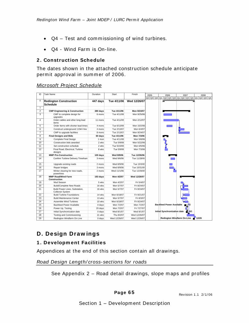
Redington Wind Farm – Joint MDEP / LURC Permit Application
Page 65
Section 1 – Development Description
• Q4 – Test and commissioning of wind turbines.
• Q4 - Wind Farm is On-line.
2. Construction Schedule
The dates shown in the attached construction schedule anticipate permit approval in summer of 2006.
Microsoft Project Schedule
ID Task Name Duration Start Finish
0 Redington ConstructionSchedule
447 days Tue 4/11/06 Wed 12/26/07
12 CMP Engineering & Construction 380 days Tue 4/11/06 Mon 9/24/073 CMP to complete design for
upgrades6 mons Tue 4/11/06 Mon 9/25/06
4 Order cables and other long leaditems
11 mons Tue 4/11/06 Mon 2/12/07
5 Order items with shorter lead times 4 mons Tue 6/13/06 Mon 10/2/066 Construct underground 115kV line 4 mons Tue 2/13/07 Mon 6/4/077 CMP to upgrade facilities 8 mons Tue 2/13/07 Mon 9/24/078 Final Designs and Bids 60 days Tue 4/11/06 Mon 7/3/069 Complete Final Design 1 mon Tue 4/11/06 Mon 5/8/06
10 Construction bids awarded 2 wks Tue 5/9/06 Mon 5/22/0611 Set construction schedule 2 wks Tue 5/23/06 Mon 6/5/0612 Final Road, Electrical, Turbine
designs8 wks Tue 5/9/06 Mon 7/3/06
13 MMP Pre-Construction 100 days Wed 8/9/06 Tue 12/26/0614 Confirm Turbine Delivery Timeframe 3 mons Wed 9/6/06 Tue 11/28/06
15 Upgrade existing roads 2 mons Wed 8/9/06 Tue 10/3/0616 Repair bridges 3 mons Wed 8/9/06 Tue 10/31/0617 Winter clearing for new roads,
powerlines2 mons Wed 11/1/06 Tue 12/26/06
18 MMP Road/Wind FarmConstruction
193 days Mon 4/2/07 Wed 12/26/07
19 Mud Season 5 wks Mon 4/2/07 Fri 5/4/0720 Build/Complete New Roads 16 wks Mon 5/7/07 Fri 8/24/0721 Build Power Lines, Substation,
Collector System16 wks Mon 5/7/07 Fri 8/24/07
22 Build Turbine Foundations 14 wks Mon 6/18/07 Fri 9/21/0723 Build Maintenance Center 13 wks Mon 5/7/07 Fri 8/3/0724 Assemble Wind Turbines 10 wks Mon 6/18/07 Fri 8/24/0725 Backfeed Power Available 0 days Mon 7/2/07 Mon 7/2/0726 Power Up, Testing 20 days Mon 7/2/07 Fri 7/27/0727 Initial Synchronization date 0 days Wed 8/1/07 Wed 8/1/0728 Testing and Commissioning 21 wks Thu 8/2/07 Wed 12/26/0729 Redington Windfarm On-Line 0 days Wed 12/26/07 Wed 12/26/07
Backfeed Power Available 7/2
Initial Synchronization date 8/1
Redington Windfarm On-Line 12/26
Q2 Q3 Q4 Q1 Q2 Q3 Q4 Q1 Q2 Q3 Q4 Q1 Q2 Q3 Q42005 2006 2007 2008
1. Development Facilities
Appendices at the end of this section contain all drawings.
Road Design Length/cross-sections for roads
See Appendix 2 – Road detail drawings, slope maps and profiles
D. Design Drawings
Revision 1.1 2/1/06
Redington Wind Farm – Joint MDEP / LURC Permit Application
Page 66
Section 1 – Development Description
See Appendix 3.0 – Wetland inset maps
See Appendix 12.0 – Road reference photo collection (on the permitting cd).
Bridges
See Appendix 4.0 – Bridge design drawings
Parking, traffic
See Section 13, Property Maintenance for drawings of the Maintenance Center and parking lot. In addition, refer to road drawings in Appendix 2 at the end of this Section.
Dimensions, Foundation design of Maintenance Center
See Section 13, Property Maintenance for details on the Maintenance Center.
Electrical Design - collector system, power lines and substation
See Appendix 5.0 – Electrical design drawings and E-Series transmission maps
2. Site Work
Foundation Designs of Wind Turbines
See Appendix 7.0 – Foundation design drawings
3. Existing Facilities
See project base map for location of all existing facilities.
Revision 1.1 2/1/06
Redington Wind Farm – Joint MDEP / LURC Permit Application
Page 67
Section 1 – Development Description
1. Calculations by Ron Nierenberg, Consulting Meteorologist from Camas, Washington, based on examination of wind data from meteorological towers at the Redington site.
2. Davulis, John, Sales Forecast, Volume III-A, Central Maine Power Company, Augusta, Maine, Pre-filed Direct Testimony to the Maine Public Utilities Commission, Investigation of Central Maine Power Company’s Stranded Cost Revenue Requirement and Rate Design, docket No. 2001-232 Phase II. October 3, 2001.
3. Based on the December 2004 annual report NEPOOL Marginal Emissions Rate Analysis produced annually by the Independent System Operator of New England.
4. ISO-NE’s 2004 Annual Markets Report, p. 15.
5. Stephen G. Ward, Public Advocate, March 7, 2004 Article Will Maine Consumers of Electricity Face the California Problem?
6. “Maine on Right Energy Course”, Bangor Daily News, August 30, 2005.
7. 35-A MRSA c. 34
8. “Regional System Plan 2005: Executive Summary”, ISO New England
9. Wind Energy Update, National Renewable Energy Lab, January 2005
10. ISO-NE’s 2004 Annual Markets Report, p. 24.
References
Redington Wind Farm – Joint MDEP / LURC Permit Application
Page 68
Section 1 – Development Description
E. Appendices (located on document CD) 1.0 – Project Base Map
1.1 – LURC Land Use Guidance Maps Project Base Map with LURC Zones Identified (PDF)
Redington Township (PDF)
Coplin Plantation (PDF)
Wyman Township (PDF)
1.2 (P-SG) Soil and Geology Protection Subdistrict Detail Map
2.0 – Road Design Narrative 2.1 C-Series Mountain Road Maps - Black Nubble & Redington
2.2 Road Section Detail - "Toolbox" of road section designs
2.3 W-Series Mountain Drainage Analysis Maps
2.4 Cut / Fill Road Analysis Detail
2.5 Slope Maps
2.6 Narrow Road Specification
2.7 Deluca-Hoffman Site Visit Notes
3.0 – Road and Substation Wetland Detail Maps
4.0 – Bridge Design Narrative 4.1 – Bridge Design Drawings
4.2 – Bridge Crossing Locations
5.0 – Electrical System 5.1 – Collector System and Substation Design
5.2 – Collector System Design Appendices
5.3 – Transmission Line Construction Plan
5.4 – CMP System Impact Study
5.5 – E Series Maps
E1 : Black Nubble Transmission Line Map
E2 : Redington Transmission Line Lower Map
E3 : Redington Transmission Line Upper Map
Redington Wind Farm – Joint MDEP / LURC Permit Application
Page 69
Section 1 – Development Description
5.6 – Turbine SCADA System Details
SCADA Network Specifications
Fiber Optic Cable Specification
6.0 – Vestas V90 General Specifications
7.0 – Wind Turbine Foundation Details Patrick & Henderson Design
Gravity Type
Rock Anchored
7.1 – Patrick & Henderson Drawings (Preferred Design) Foundation Design Drawing
Foundation Installation Photo Gallery
8.0 – Turbine Transportation and Assembly 8.1 – Transportation Images
8.2 – Turbine Installation Video (Vestas promo)
8.3 – Vestas V90 Road & Transport Specifications
9.0 – FAA Lighting 9.1 – Turbine Latitude/Longitude Coordinates
9.2 – FAA Lighting Map
9.3 – Light Beacon Light Distribution Diagram
10.0 – Demonstrated Need 10.1 – Electricity Shopping Becoming Essential
10.2 – Windfall from the Wind Farm
10.3 – U.S. Dept. of Energy White Paper
10.4 – Fuel Diversity Need - ISO NE Report
10.5 – DOE Maine Wind Energy Map
10.6 – NRCM Data on Maine Dams
10.7 – Pollution Avoided Spreadsheet
10.8 – PUC Executive Summary on MWEA
11.0 – Public Support
Redington Wind Farm – Joint MDEP / LURC Permit Application
Page 70
Section 1 – Development Description
11.1 – Supporters Database List
11.2 – Hiker Support Letters
12.0 – Road Reference Photo Collection 12.1 – Existing Bridge Images 1
12.2 – Existing Bridge Images 2
12.3 – Map/Photo Key Writeup for Above Images
12.4 – Existing Bridge, Road and Terrain Photos
12.5 – Map/Photo Key Writeup for Above Image


![Process Description(Final)[1]](https://img.pdfslide.us/doc/110x75/55cf9d8f550346d033ae2931/process-descriptionfinal1.jpg)