Embed Size (px)
Citation preview
Supplemental Archaeological Assessment
Second Avenue Subway:
96th Street Station
New York, New York
Prepared for:
MTA New York City Transit
New York, NY
Prepared by:
AKRF, Inc.
440 Park Avenue South
New York, New York 10016
April 2009

Management Summary
SHPO Project Review Number: 05PR00975
Involved Agencies: Metropolitan Transportation Authority New York City
Transit
Federal Transit Administration
Phase of Survey: Supplemental Phase 1A Archaeological Assessment
Location: Second Avenue between East 90th and East 105th
Streets
Minor Civil Division: 06101: Manhattan
County: New York County
Survey Area Length: Approximately 1600 feet
Survey Area Width: Variable; between approximately 600 and 1200 feet
Number of Acres Surveyed: Approximately 16
USGS 7.5 Minute Quadrangle Map: Central Park
Report Author: Elizabeth D. Meade, RPA
Date of Report: April 2009

i
Table of Contents
Chapter 1: Introduction and Methodology ............................................................................................................... 1
A. Project Overview and Background .................................................................................................................. 1
B. Previously Analyzed Portions of the 96th Street Station APE ........................................................................ 2
C. Research Goals and Methodology ................................................................................................................... 2
Chapter 2: Environmental Context ............................................................................................................................ 3
A. Original Topographic Setting .......................................................................................................................... 3
B. Soil Profile ...................................................................................................................................................... 5
Chapter 3: Precontact Archaeological Resources ..................................................................................................... 6
A. Previous Precontact Archaeological resources Assessments for this Area...................................................... 6
B. Precontact Sensitivity for Supplemental Locations ......................................................................................... 6
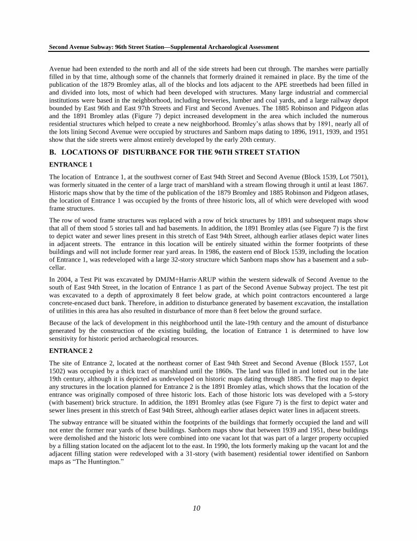
Chapter 4: Historic Period Archaeological Resources ............................................................................................. 9
A. Historic Context .............................................................................................................................................. 9
B. Locations of Disturbance for the 96th Street Station ..................................................................................... 10
Entrance 1: Block 1539, Lot 750 ................................................................................................................... 10
Entrance 2: Block 1557, Lot 1502 ................................................................................................................. 10
Entrance 3: Block 1541, Lot 21 ..................................................................................................................... 11
Ancillary 1: Block 1556, Lot 1 ...................................................................................................................... 11
Utility Installations within Block 1647, Lot 1 ............................................................................................... 11
Utility Relocations in Side Streets ................................................................................................................. 11
Chapter 5: Conclusions and Recommendations ..................................................................................................... 14
A. APE Sensitivity ............................................................................................................................................. 15
Disturbance Assessment ................................................................................................................................ 14
Precontact Sensitivity Assessment ................................................................................................................ 14
Historic Sensitivity Assessment .................................................................................................................... 15
B. Recommendations ......................................................................................................................................... 27
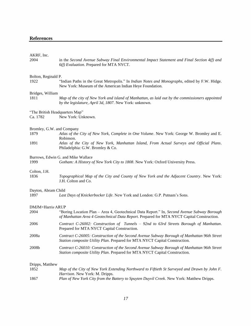
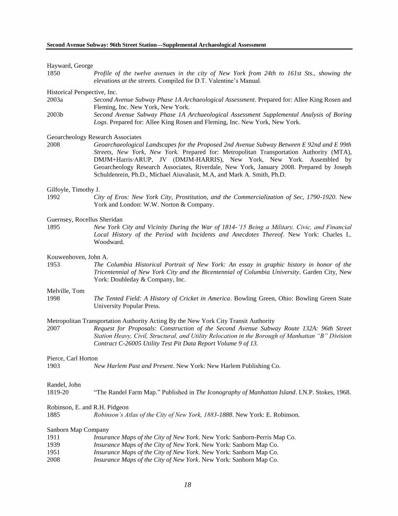
References .................................................................................................................................................................. 17
Figures
ii
List of Figures
Figure 1: APE Location; USGS Map, Central Park Quadrangle.
Figure 2: APE Boundaries; Sanborn Insurance Map 2007.
Figure 3: Topographical Map of the City of New York; E. Viele, 1865.
Figure 4: Topographical Map of the City and County of New York; J.H. Colton, 1836.
Figure 5: Map of that Part of the City and County of New York North of 50th Street; M. Dripps, 1851.
Figure 6: Plan of New York City; M. Dripps, 1867.
Figure 7: Atlas of New York City; G.W. Bromley, 1891.
List of Tables
Table 1: Street Elevation Changes Over Time .............................................................................................................. 4
Table 2: Soil Levels Identified by GRA (2008) ............................................................................................................ 5
1
Chapter 1: Introduction and Methodology
A. PROJECT OVERVIEW AND BACKGROUND
The Metropolitan Transportation Authority (MTA), in cooperation with New York City Transit (NYCT), is planning
to construct the 96th Street Station of the Second Avenue Subway (see Figure 1). This Supplemental Archaeological
Assessment to the Second Avenue Subway Phase 1A Archaeological Assessment has been prepared in accordance
with the provisions of the Second Avenue Subway project’s Programmatic Agreement, among the Federal Transit
Administration (FTA), MTA New York City Transit, and the New York State Historic Preservation Officer (SHPO),
executed April 8, 2004. The PA sets forth the steps to be followed for ―any changes to the project that introduce new
project elements that would involve subsurface construction and for which the effects of such construction have not
yet been analyzed.‖ For these areas, archaeological investigation should be conducted in consultation with the SHPO
and the New York City Landmarks Preservation Commission (LPC).
FTA issued a Record of Decision (ROD) for the Second Avenue Subway project on July 8, 2004. The ROD was
issued based on the findings presented in the Second Avenue Subway Final Environmental Impact Statement and
Final Section 4(f) and 6(f) Evaluation (FEIS; April 2004), which examined the potential impacts of the 8.5-mile-
long Second Avenue Subway from East 125th Street in Harlem to Hanover Square in Lower Manhattan. The FEIS
identified the environmental impacts of the Second Avenue Subway during its construction and the permanent
impacts once the subway is operational. It also identified mitigation measures to alleviate the identified impacts. The
assessment of the Second Avenue Subway’s proposed alignment, ancillary facilities, stations, and station entrances
presented in the FEIS was based on conceptual and preliminary engineering. As part of the FEIS, a Phase 1A
Archaeological Assessment of the Second Avenue Subway, as well as several addenda to the Phase 1A, were
prepared by Historical Perspectives, Inc. (HPI) in 2003 (HPI 2003a).
Since the execution of the PA, completion of the FEIS, and issuance of the ROD, the design for the Second Avenue
Subway has advanced and additional archaeological analysis has been conducted in accordance with the provisions
of the PA (see below for a discussion of archaeological analyses completed since the completion of the FEIS). Plans
for station entrances and ancillary facilities were not finalized at the time of the completion of the FEIS. At this
time, design for the 96th Street Station have advanced considerably and include areas located outside of the Area of
Potential Effect (APE) analyzed in the FEIS. Therefore, consistent with the requirements of the PA, this assessment
was prepared to evaluate the potential for impacts to archaeological resources in the new APE at the 96th Street
Station.
In the vicinity of the 96th Street Station, the APE analyzed in HPI’s Phase 1A Archaeological Assessment,
addended, included the streetbed of Second Avenue from western building line to eastern building line (with several
exceptions, please see Section B, below). No evaluation was conducted at that time for any of the station’s
entrances, ancillary facilities, or utility relocations on streets other than Second Avenue. This Supplemental
Archaeological Assessment of the 96th Street Station analyzes the archaeological sensitivity of any areas of planned
construction that fall outside the archaeological APE already evaluated. These locations include station entrances,
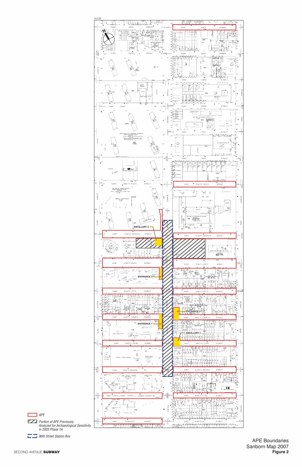
ancillary facilities, and utility relocations. This includes the following (see Figure 2):
An entrance at the southwest corner of Second Avenue and 94th Street.
An entrance at the northeast corner of Second Avenue and 94th Street.
An entrance at the southwest corner of Second Avenue and 96th Street.
An ancillary facility at the northeast corner of Second Avenue and 93rd Street.
Second Avenue Subway: 96th Street Station—Supplemental Archaeological Assessment
2
Utility relocations in all side streets between East 90th and East 99th Streets for up to one block east
and west of Second Avenue as well as within East 105th Street for one block east of Second Avenue
The station’s ancillary facility at the southwest corner of Second Avenue and 97th Street falls with the
APE already analyzed in the FEIS.
B. PREVIOUSLY ANALYZED PORTIONS OF THE 96TH STREET STATION APE
The main ―box‖ that will house the 96th Street Station falls mainly within Second Avenue between an area just
north of East 97th Street and an area to the south of East 92nd Street. The portion of this area to the north of East
94th Street was identified in the 2003 Phase 1A and a supplemental analysis of soil boring logs (completed in
December 2003) as sensitive for precontact archaeological resources to depths of more than 20 feet below the
ground surface.
In addition to the streetbed of Second Avenue, the 2003 Phase 1A Archaeological Assessment examined two areas
in adjacent blocks and lots. The first of these was identified as ―Shaft Site B‖ in the Phase 1A and was located
within Block 1668, Lot 1. The assessment determined that this area was not sensitive for archaeological resources
dating to either the precontact or historic periods. The second location analyzed in the 2003 Phase 1A was identified
as ―Shaft Site C‖ in the Phase 1A on Block 1646, Lot 28 (Ancillary 2 of the 96th Street Station is located in this
area). The assessment determined that this area was sensitive for precontact archaeological resources within a layer
of shell and peat deposits located between approximately 13 and 29 feet below grade. HPI recommended additional
archaeological research in all of the locations identified as sensitive.
To refine the recommendations presented in the 2003 Phase 1A, a subsequent geoarchaeological analysis of the soils
within the Second Avenue streetbed between East 92nd and East 99th Streets was completed by Geoarcheology
Research Associates (GRA) in January 2008 (discussed in greater detail in Chapters 2 and 3). The GRA report
included an intensive analysis of soil boring records and concluded that while some soil levels within the areas
identified as sensitive by HPI in the 2003 Phase 1A may have moderate sensitivity for precontact archaeological
resources, the thin and broad distribution of those deposits was such that additional monitoring was not
recommended. Therefore, GRA revised the sensitivity determination of the 2003 Phase 1A report and additional
archaeological research was not necessary. SHPO concurred with this assessment in comments dated April 2, 2008.
C. RESEARCH GOALS AND METHODOLOGY
The goal of this Supplemental Archaeological Assessment is to determine the likelihood that potential
archaeological resources have survived in the portions of the APE not evaluated in previous archaeological
assessments. The study has been designed to satisfy the requirements of the State Historic Preservation Office
(SHPO, 2005) and the New York City Landmarks Preservation Commission (LPC, 2002) and it follows the
guidelines of the New York Archaeological Council (NYAC, 1994). The study documents the history of the APE as
well as its potential to yield archaeological resources including both precontact and historic cultural resources.
In order to determine the extent to which archaeological resources within the APE may have been disturbed,
numerous primary and secondary sources were examined. Cultural resources assessments of the project site and
vicinity (including the 2003 Phase 1A Archaeological Assessment and the 2008 GRA geoarchaeological analysis) of
the APE were reviewed. In addition, historic maps and atlases were examined to determine a chronology for the
development of the APE. Finally, soil boring records (including soil borings analyzed for the FEIS and others that
were completed after the FEIS was published) were reviewed to create a soil profile for the APE which could be
used to assess its archaeological sensitivity. Finally, local histories, historic newspapers, and historic photographs
were also reviewed as necessary.
3
Chapter 2: Environmental Context
A. ORIGINAL TOPOGRAPHICAL SETTING
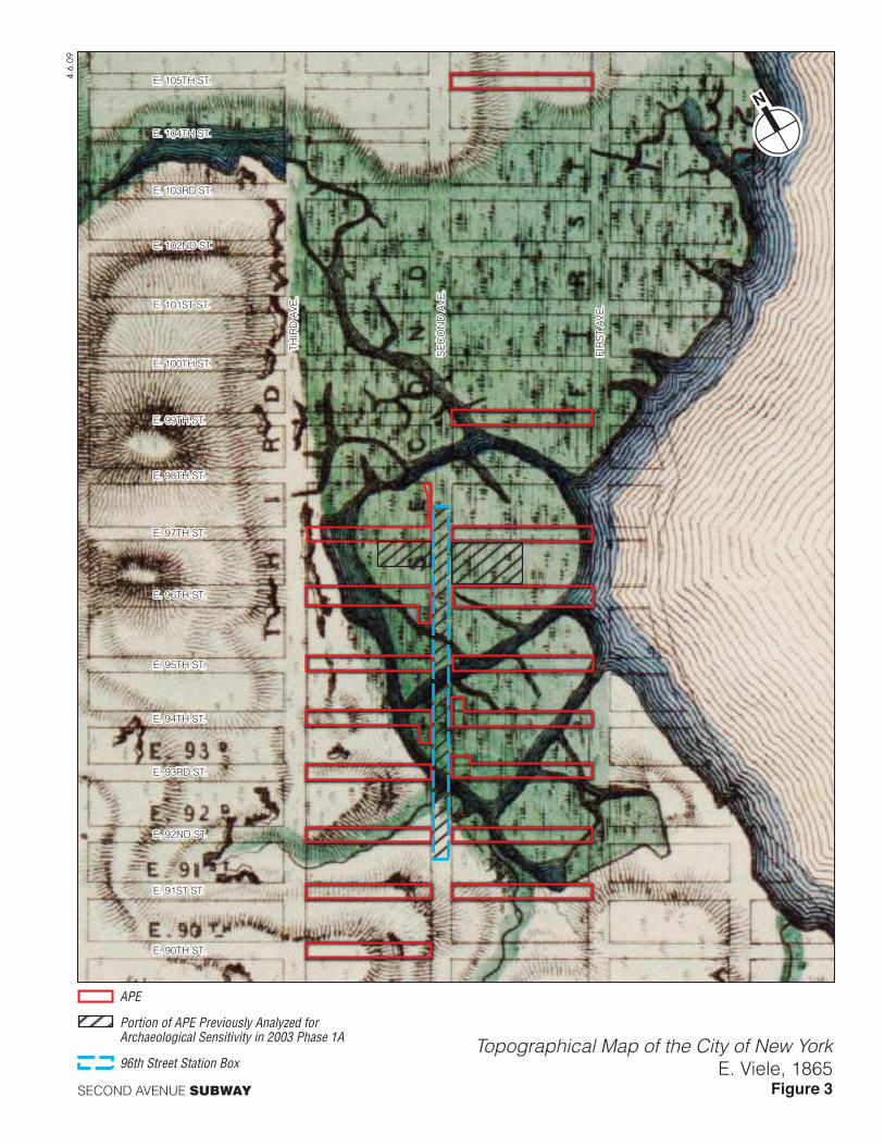
Historic maps1 show that the majority of the 96th Street Station APE was originally covered with a large tract of
marshland. The 1865 Viele map (Figure 3) shows that the streetbed of Second Avenue was inundated by the swamp
between approximately East 93rd and East 103rd Streets. The Harlem Creek was situated several blocks to the north,
bordered with thick tracts of marshland leaving a narrow neck of dry land between modern East 103rd and East
106th Streets east of modern Park Avenue (shown on the Viele map as Fourth Avenue). This stretch of land, later
known as Benson’s Point, was ―little more than a mound of sand, rising above the marshland [and] overflowed by
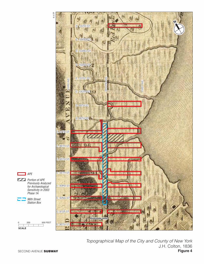
high tides‖ (Bolton 1922: 71). Other historic maps, including the 1811 Bridges and 1836 Colton (Figure 4) maps of
Manhattan, depict tall hills bordering the marsh south of East 92nd Street. Several of the streetbeds in the APE—
including East 90th and East 91st Streets east and west of Second Avenue, East 92nd and East 93rd Streets west of
Second Avenue, and portions of East 94th through East 97th Street west of Second Avenue—were composed of dry
land rather than marsh and Viele’s map depicts hills of varying size in all of these locations. In addition, the eastern
ends of East 95th through East 98th Streets near modern First Avenue were completely inundated by the Harlem
River.
The marsh was created between approximately 6,000 and 3,500 years before present [BP], after thousands of years
of sea level changes caused by retreating glaciers (GRA 2008). The marsh was present in this area until the late-19th
century, when it was filled in and developed as the population of Manhattan grew. The maps also show that the
marsh was drained by numerous streams of varying size, several of which cut across the streetbeds in the APE.
These channels were likely altered and redirected by settlers during the historic period, at which time the area was
known as ―Hellgate Bay‖ (ibid).
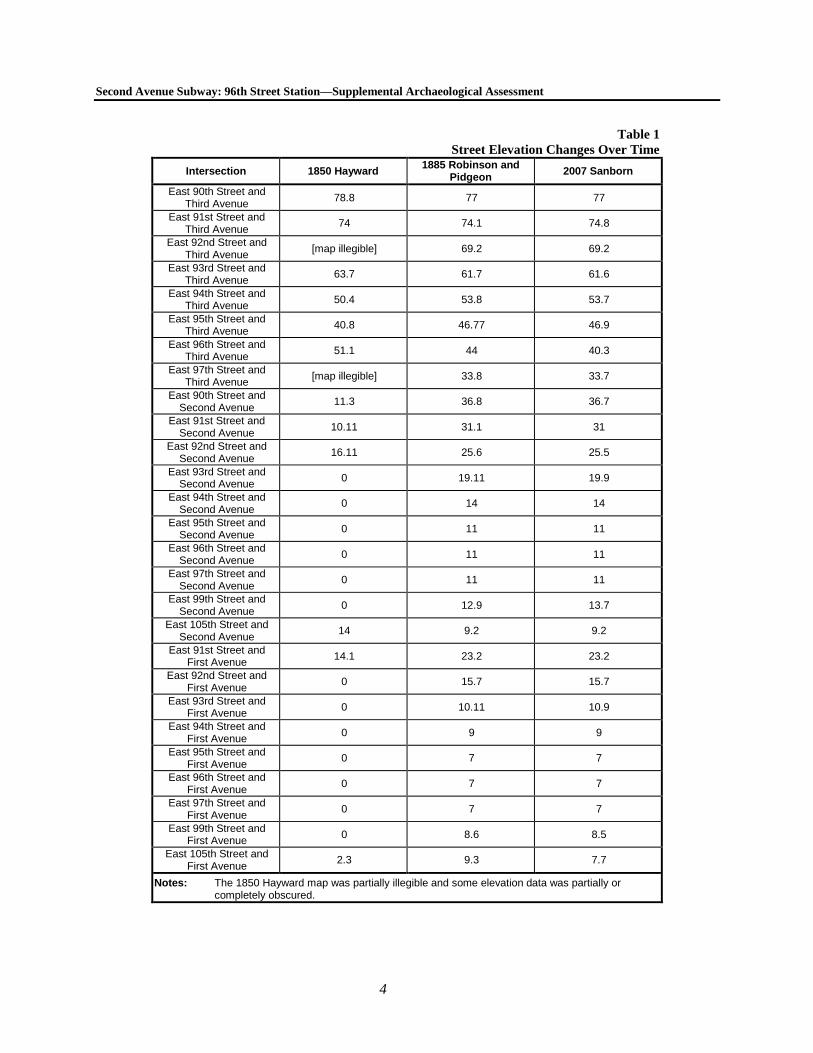
Historic atlases from the late-19th century show that the elevation of Second Avenue varied. George Hayward’s
1850 map, Profile of the Twelve Avenues in the City of New York from 24th to 161st Streets Shewing (sic) the
Elevations at the Streets, shows that the elevation of Second Avenue dropped steeply between East 87th and East
92nd Streets until it reached sea level in the vicinity of the marsh. The 1885 Robinson and Pidgeon atlas includes
elevations at most street intersections, many of which had changed since Hayward’s 1850 map was prepared. A
summary of the street elevation changes as depicted on three maps (dating to 1850, 1885, and 2007) is presented in
Table 1, below. While modern topographic evidence suggests that the elevations of some locations within the APE
have changed very little since the mid- to late-19th century, others appear to have been subjected to significant
landscape modification over time. In many locations, large amounts of fill have been added (in the locations of the
former marsh) while other locations have been graded and their elevations have been lowered by several feet.
1 Historic maps reviewed for this project included the 1865 Viele map depicting Manhattan’s original topography
(Figure 4), ca. 1782 British Headquarters map, the 1811 Bridges version of ―The Commissioners’ Plan,‖ the 1820
Randel farm map, the 1836 Colton map (Figure 4), the 1851 and 1867 Dripps maps (Figures 5 and 6), the 1879
and 1891 (Figure 7) Bromley atlases, the 1885 Robinson and Pidgeon atlas, and the 1896, 1911, 1939, 1951, and
2007 (Figure 2) Sanborn maps.
Second Avenue Subway: 96th Street Station—Supplemental Archaeological Assessment
4
Table 1
Street Elevation Changes Over Time
Intersection 1850 Hayward 1885 Robinson and
Pidgeon 2007 Sanborn
East 90th Street and Third Avenue
78.8 77 77
East 91st Street and Third Avenue
74 74.1 74.8
East 92nd Street and Third Avenue
[map illegible] 69.2 69.2
East 93rd Street and Third Avenue
63.7 61.7 61.6
East 94th Street and Third Avenue
50.4 53.8 53.7
East 95th Street and Third Avenue
40.8 46.77 46.9
East 96th Street and Third Avenue
51.1 44 40.3
East 97th Street and Third Avenue
[map illegible] 33.8 33.7
East 90th Street and Second Avenue
11.3 36.8 36.7
East 91st Street and Second Avenue
10.11 31.1 31
East 92nd Street and Second Avenue
16.11 25.6 25.5
East 93rd Street and Second Avenue
0 19.11 19.9
East 94th Street and Second Avenue
0 14 14
East 95th Street and Second Avenue
0 11 11
East 96th Street and Second Avenue
0 11 11
East 97th Street and Second Avenue
0 11 11
East 99th Street and Second Avenue
0 12.9 13.7
East 105th Street and Second Avenue
14 9.2 9.2
East 91st Street and First Avenue
14.1 23.2 23.2
East 92nd Street and First Avenue
0 15.7 15.7
East 93rd Street and First Avenue
0 10.11 10.9
East 94th Street and First Avenue
0 9 9
East 95th Street and First Avenue
0 7 7
East 96th Street and First Avenue
0 7 7
East 97th Street and First Avenue
0 7 7
East 99th Street and First Avenue
0 8.6 8.5
East 105th Street and First Avenue
2.3 9.3 7.7
Notes: The 1850 Hayward map was partially illegible and some elevation data was partially or completely obscured.

Chapter 2: Environmental Context
5
B. SOIL PROFILE
As previously discussed, in January 2008, a geoarchaeological analysis of the streetbed of Second Avenue between
92nd and 99th Streets was completed by GRA. The study identified 6 typical soil levels, referred to in the report as
Analytical Units (AU) I through VI, in the area. These levels ranged from bedrock (AU-I) through the upper cap of
modern and historic fill (AU-VI). The sediments above the bedrock level and beneath the modern fill dated to
between approximately 20,000 years and 230 years BP and indicated that significant landscape modification and
landfilling took place throughout the APE during the 19th century. These analytical units are summarized in Table 2.
Table 2
Soil Levels Identified by GRA (2008)
Analytical Unit
Approximate Age
(Years BP)
Approximate Depth
(Feet Below Ground Surface)
Description
AU-I Unknown 60+ Bedrock
AU-II Earlier than 15,000 to
12,000 40 to 60 Sediments associated with a glacial lake
AU-III 12,000 to 5,000 34 to 40 Sands marking the interim period between the retreat of
glacial lakes and the formation of marshes
AU-IVa 5,000 to 4,000 27 to 34 Sediments associated with the transition from freshwater to
salt marsh
AU-IVb 4,000 to 2,500 19 to 27 Sediments associated with the transition from a salt marsh to
an inundated mudflat
AU-IVc 2,500 to 200 18.5 to 19 Sediments associated with a stable mudflat
AU-V 200 to present
16 to 18 Late 19th century landfill
AU-VI 0 to 16 Historic and modern fill, immediately below grade.
Notes: Not all AUs were present in all locations; approximate depths are taken form Boring AB-2A, located on the eastern side of Second Avenue between East 93rd and East 94th Streets and approximate age of each soil level was extracted from Table 3 (“Chrono-Stratigraphic summary”) of the 2008 GRA report (p. 58).
Sources: GRA (2008).
The GRA report concluded that levels AU-IVa and AU-IV-b, which date to the time of the transition of the land
from a freshwater to a saltwater marsh, had moderate and low to moderate potential, respectively, for precontact
archaeological resources. However, because of the thin and localized distribution of the potentially sensitive levels,
GRA determined that the project area did not possess enough research value to warrant additional archaeological
monitoring (see Chapter 3 for a more detailed discussion of the site’s precontact sensitivity).
6
Chapter 3: Precontact Archaeological Resources
A. PREVIOUS PRECONTACT ARCHAEOLOGICAL RESOURCES SENSITIVITY
ASSESSMENTS
The precontact sensitivity of sites in New York City is generally evaluated by the presence of level slopes, water
courses, well-drained soils, and close proximity to previously identified precontact archaeological sites. As stated
previously, historic maps show that the area of the 96th Street Station was formerly a large tract of marshland
punctuated by numerous small streams and channels.
Using soil borings, historic maps, and other documentary sources, HPI identified areas of precontact archaeological
sensitivity in the location of the 96th Street station in their 2003 Phase 1A Archaeological Assessment and in a
supplemental analysis of boring logs (also prepared in 2003). These assessments identified three areas of
archaeological sensitivity within the 96th Street Station APE: the streetbed of Second Avenue between East 106th
and East 95th Streets outside of the footprint of the existing Second Avenue Subway tunnel (between 0 and 22 feet
below grade); the site of ventilation Shaft C on Block 1646 (between 13 and 29 feet below grade); and the western
side of Second Avenue between East 94th and East 95th Streets (between 10 and 15 feet below grade). The potential
precontact archaeological resources in this area were expected to relate to habitation, camping, and hunting sites and
could also have included shell middens.
In January 2008, subsequent to HPI’s analyses of the 96th Street station, GRA completed its aforementioned study
to refine recommendations presented by HPI in the 2003 Phase 1A Archaeological Assessment. GRA’s report
identified the area surrounding the 96th Street station as an ideal location for resource exploitation by Native
Americans during the precontact period. As mentioned previously, the study identified 6 main soil levels or
Analytical Units (AU) identified in the report as AU-I through AU-VI, ranging from bedrock through modern and
historic fill.
Based on an analysis of the APE’s original topographic setting, soil borings, and the level of preservation that each
level was likely to provide, all but one of the AUs were determined to have low sensitivity for precontact
archaeological resources. Level, AU-IVa, was determined to have moderate potential for archaeological resources
and portions of level AU-IVb were determined to have low to moderate sensitivity. The potentially sensitive
sediments in those layers dated to the Late Archaic period, between approximately 4,200 and 3,000 years BP and
represented a transitional environment from freshwater marsh/shoreline to brackish marsh. The sensitive levels were
identified between 15 and 25 feet below the ground surface north of 93rd Street. However, the report concluded that
these ―cultural deposits are likely to be thin and feature a broad and irregular lateral distribution‖ (GRA 2008: 56).
Therefore, because large intact precontact archaeological sites were not likely to be encountered, continuous
monitoring was not recommended, as suggested in the 2003 Phase 1A. In a letter dated April 2, 2008, SHPO
concurred with the findings of this report.
B. PRECONTACT SENSITIVITY OF SUPPLEMENTAL LOCATIONS
All of the areas formerly located within the Hellgate Bay marsh outside of the Second Avenue streetbed are
expected to have a similar soil profile to the one identified for the streetbed of Second Avenue by GRA in 2008.
Therefore, those portions of the APE analyzed in this archaeological assessment that were also located within the
former marsh are determined to have no sensitivity for precontact archaeological resources.
The only locations included within this assessment that were not included within the former marsh are the streetbeds
of East 90th through East 92nd Streets, the western portions of East 93rd through East 98th Street west of Second
Avenue, and the streetbed of East 105th Street between First and Second Avenues. These areas are depicted as dry
land on the 1865 Viele map and their precontact sensitivity is discussed below.
Chapter 3: Precontact Archaeological Resources
7
STREETBEDS OF EAST 90TH THROUGH EAST 98TH STREETS
Before the time of European contact, a precontact habitation site known as Konaande Kongh, the chief village of a
group of Native American known as the Rechgawack, was located to the west of the APE in the area now bounded
by Lexington and Madison Avenues and East 98th and East 101st Streets (Bolton 1922). The village was situated on
the high ground that overlooked the marsh that made up much of the APE (ibid).
Soil borings included in the 2003 Phase 1A Study and in GRA’s 2008 geoarchaeological analysis of the site show
that although portions of the APE were originally fast land and not marsh, a thick layer of fill is situated between the
ground surface and bedrock in most locations along Second Avenue. Soil borings included within the 2003 Phase
1A study show that the fill layer is 19 feet thick near the intersection of Second Avenue and East 90th Street and it
decreases to 13 feet at East 93rd Street. Soil borings completed by MTA New York City Transit and analyzed by
GRA show that bedrock in this area is located directly beneath a layer of fill to the south of the former marsh with
no undisturbed soil levels in between.
Historic maps depict numerous hills of varying size throughout this area. These hills are no longer reflected in
topographic data and there is evidence of significant landscape modification in the form of grading and filling
throughout the APE (see Table 1). The leveling of these hills and the cutting through of streets in preparation for the
development of the area in the late 19th century appears to have resulted in significant disturbance, as seen by thick
layer of fill evident in soil borings for the area. Precontact archaeological sites are generally very shallowly buried.
Therefore, as a result of the disturbance caused by landscape alterations in the area as well as disturbance generated
by the initial construction of the streets as well as the decades of paving, grading, and road maintenance that
followed, there is low sensitivity for archaeological resources dating to the precontact period in this location.
EAST 105TH STREET
Project plans provided by MTA New York City Transit indicate that a small amount of utility work will be
completed within East 105th Street approximately 120 to 150 feet east of Second Avenue. As depicted on the plans,
this work will involve the installation of electrical lines and vaults within the northern and southern sidewalks. Prior
to European contact, East 105th Street was included in a small ―island‖ surrounded on the north, west, and south by
marshland and on the east by the Harlem River. This neck of land was associated with the Rechgawack and was
known as Rechgawanes. The topographical setting during the precontact period suggests that it is unlikely that a
Native American habitation site was ever located there although it was probably used as a fishing location (Bolton
1922).
The 2003 Phase 1A Archaeological Assessment identified the area between East 106th and East 94th Streets as
moderately sensitive for precontact archaeological resources. The Phase 1A included soil boring logs for several
locations near the intersection of East 105th Street and Second Avenue. One of these borings (2-94), located near the
northwest corner of East 105th Street and Second Avenue, revealed the presence of 17 feet of fill below grade.
Another boring (2-93), located at the southwest corner of East 105th Street and Second Avenue, included only 3.5
feet of fill over a layer of medium-coarse brown sand with gravel and clay inclusions that extended to a depth of 13
feet below grade.
Additional borings completed by Warren George, Inc. in August 1972 as part of earlier work on the previous Second
Avenue Subway project were provided by MTA New York City Transit for this supplemental assessment. Three
borings were completed within the sidewalks of East 105th Street east of Second Avenue. The first, boring 11-25A,
was located in the southeastern corner of Second Avenue and East 105th Street. It indicated that there are
approximately 11 feet of fill and cobbles located below the surface of the sidewalk. Boring 11-26, located in the
northeastern corner of the same intersection showed the presence of approximately 15 feet of fill. This was the same
amount seen in Boring 11-27, located in the southern sidewalk of East 105th Street approximately 86 feet east of
Second Avenue. All three borings showed that a layer of red-brown or brown sand or sandy-silt was situated below
the level of fill.
Both the Randel Farm Map of 1820 and Viele’s map of 1865 (Figure 3) depict a large hill that extended north-south
across East 105th Street approximately 100 to 150 feet east of Second Avenue. This hill is not depicted on the 1836
Colton map (Figure 4), which shows that the marshes immediately west of this point of land had been filled in.
Therefore, it is possible that this hill was cut down and used to fill in the adjacent marshland or to level out the area
Second Avenue Subway: 96th Street Station—Supplemental Archaeological Assessment
8
for its later use as a horse racing track and cricket field (described in greater detail in the following chapter).
Hayward’s 1850 profile drawing of Second Avenue suggests that a small hill was formerly located between East
105th and East 107th Streets which rose to a height to 14.5 feet. As seen on the 1891 Bromley atlas (Figure 7), after
all the streets had been cut through this area, the marshes filled in, and the newly created land developed, the
elevation along Second Avenue between East 105th and East 107th Streets was relatively level at approximately 9
feet above sea level, further confirming that significant landscape alteration had taken place in this area.
As a result of the depth of fill in this area and the landscape modifications observed in the cartographic record, the
locations of utility installation within East 105th Street are determined to have no sensitivity for precontact
archaeological resources.
9
Chapter 4: Historic Period Archaeological Resources
A. HISTORIC CONTEXT
Despite its large population during the historic period, the urban center of New York City was largely restricted to
the southern end of Manhattan until the mid-19th century. Before that time, the northern portion of Manhattan was
occupied mostly by large tracts of saltwater marshes and farmland.
While most of the 96th Street Station APE was inundated by marshland, several of the streetbeds in the APE were
also located outside of the borders of the marshland, including East 90th through East 92nd Streets and the western
portions of East 93rd through East 98th Street west of Second Avenue. In addition, a small island of dry land was
located immediately to the north, in the vicinity of East 103rd through East 106th Streets. The point of dry land was
known as Montagne’s Point, after original Dutch Settler Jan Montagne Jr. (Pierce 1903), who had purchased the
land from the Native Americans in 1669 (Bolton 1922). Montagne sold the land in 1671 to Jan Louwe Bogert and
the adjacent marshes were known during this period as ―Bogert Marsh.‖
Bogert sold the land in 1706 to Captain Johannes Benson. The land became known as Benson’s Point, after Samson
Benson, who constructed a mill near East 105th Street and Third Avenue in 1740 (Stokes 1968). The mill was
burned to the ground during the Revolutionary War and reconstructed several blocks to the north at the end of the
18th century (ibid). In addition, during the War of 1812, a redoubt was located near the area located north of East
106th Street between Second and Third Avenues (ibid). In addition, in his description of fortifications during the
War of 1812, Rocellus Sheridan Guernsey (1895) stated that a battery may have been located in the vicinity of East
105th Street and Second Avenue, although no other information confirming this as the site of the former battery
could confirm be located. No fortifications or structures of any kind are visible in the area on any late 18th or early
19th century maps, including the 1782 British Headquarters map and the 1811 Bridges maps.
Little development occurred in this area of Manhattan until the mid- to late-19th century when the northward
dispersal of the population prompted the filling of the marsh located between approximately East 92nd and East
103rd Streets, Third Avenue, and the Harlem River. Historic maps including the 1811 Bridges Map, the 1820
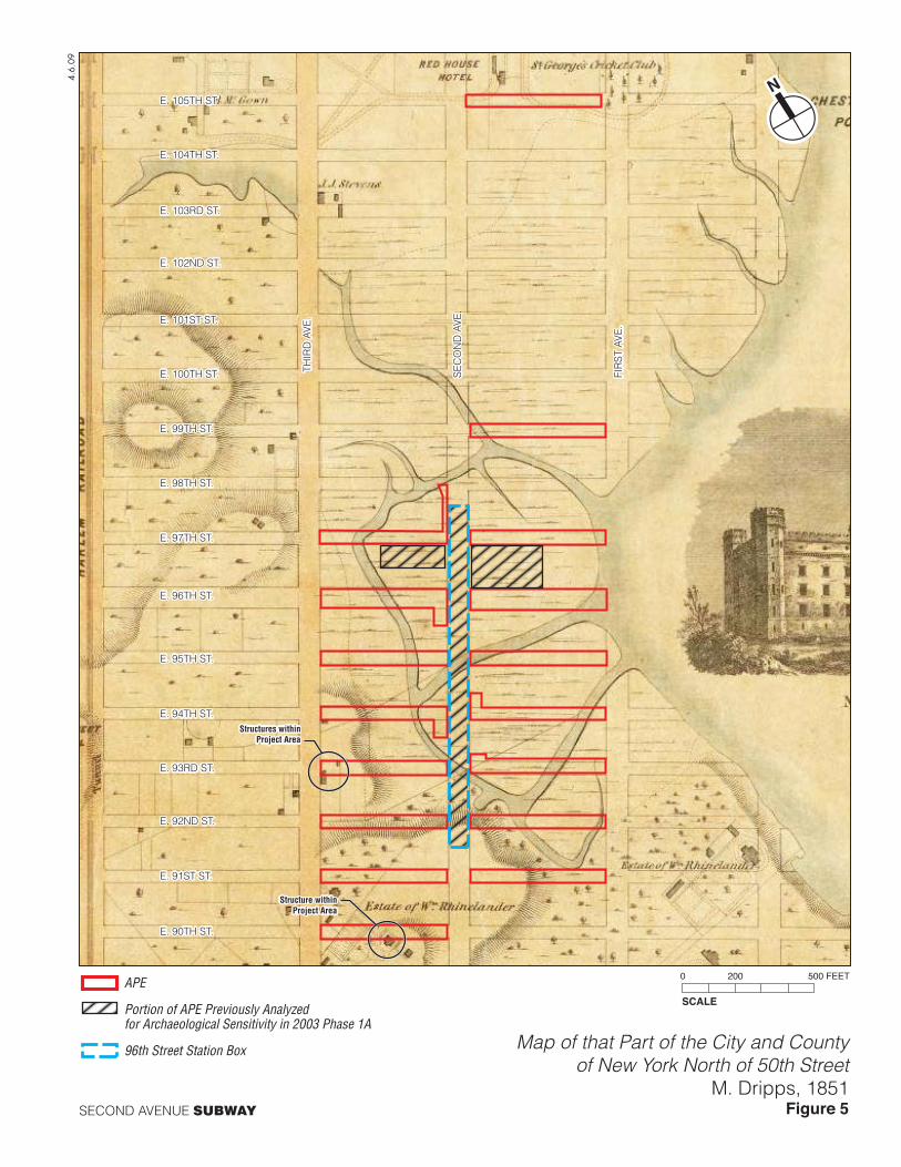
Randel map, the 1836 Colton Map (Figure 4), and the 1851 Dripps map (Figure 5) show that the structures entered
the APE or its vicinity in only three locations throughout the early- and mid-19th century (discussed in greater detail
below). Prior to the mid-19th century, some small communities had been established nearby, including Yorkville, a
predominantly German enclave located to the south of the 96th Street Station APE. The area was not heavily
developed in part because streets had not been cut through the area, although they had been planned by the City’s
Street Commissioners decades earlier. Dripps’ 1851 map shows that none of the APE streetbeds had been
constructed by the mid-19th century and that Second Avenue extended only as far north as East 86th Street by the
middle of the century.
However, in the late-19th century, the development of Harlem increased substantially. Much of the development
was brought about by the Tammany political machine and was heavily influenced by William Tweed, who was at
the time the commissioner of the Department of Public Works (Burrows and Wallace 1999). The majority of
development was located between Third and Fifth Avenues and East 59th and East 110th Streets because this area
was ―easy to grade, dig up, and build upon‖ (ibid: 929). Industrial development shifted east toward the river while
crews of workers constructed streets and laid down sewer, water, and gas lines for the homes that were to be
developed there (ibid). Second Avenue was lined with 4-story tenements that were intended to create a community
more appealing to the working class than the crowded slums downtown (ibid). The growth of these neighborhoods
was largely due to the establishment of elevated train lines along Second and Third Avenues, which allowed
individuals to work in Manhattan’s downtown commercial center and live in residential districts uptown.
Dripps’ map of New York City published in 1867 (Figure 6) is the first to depict the growth and development of the
area surrounding the 96th Street Station. The map shows that Yorkville had expanded substantially and that Second
Second Avenue Subway: 96th Street Station—Supplemental Archaeological Assessment
10
Avenue had been extended to the north and all of the side streets had been cut through. The marshes were partially
filled in by that time, although some of the channels that formerly drained it remained in place. By the time of the
publication of the 1879 Bromley atlas, all of the blocks and lots adjacent to the APE streetbeds had been filled in
and divided into lots, most of which had been developed with structures. Many large industrial and commercial
institutions were based in the neighborhood, including breweries, lumber and coal yards, and a large railway depot
bounded by East 96th and East 97th Streets and First and Second Avenues. The 1885 Robinson and Pidgeon atlas
and the 1891 Bromley atlas (Figure 7) depict increased development in the area which included the numerous
residential structures which helped to create a new neighborhood. Bromley’s atlas shows that by 1891, nearly all of
the lots lining Second Avenue were occupied by structures and Sanborn maps dating to 1896, 1911, 1939, and 1951
show that the side streets were almost entirely developed by the early 20th century.
B. LOCATIONS OF DISTURBANCE FOR THE 96TH STREET STATION
ENTRANCE 1
The location of Entrance 1, at the southwest corner of East 94th Street and Second Avenue (Block 1539, Lot 7501),
was formerly situated in the center of a large tract of marshland with a stream flowing through it until at least 1867.
Historic maps show that by the time of the publication of the 1879 Bromley and 1885 Robinson and Pidgeon atlases,
the location of Entrance 1 was occupied by the fronts of three historic lots, all of which were developed with wood
frame structures.
The row of wood frame structures was replaced with a row of brick structures by 1891 and subsequent maps show
that all of them stood 5 stories tall and had basements. In addition, the 1891 Bromley atlas (see Figure 7) is the first
to depict water and sewer lines present in this stretch of East 94th Street, although earlier atlases depict water lines
in adjacent streets. The entrance in this location will be entirely situated within the former footprints of these
buildings and will not include former rear yard areas. In 1986, the eastern end of Block 1539, including the location
of Entrance 1, was redeveloped with a large 32-story structure which Sanborn maps show has a basement and a sub-
cellar.
In 2004, a Test Pit was excavated by DMJM+Harris∙ARUP within the western sidewalk of Second Avenue to the
south of East 94th Street, in the location of Entrance 1 as part of the Second Avenue Subway project. The test pit
was excavated to a depth of approximately 8 feet below grade, at which point contractors encountered a large
concrete-encased duct bank. Therefore, in addition to disturbance generated by basement excavation, the installation
of utilities in this area has also resulted in disturbance of more than 8 feet below the ground surface.
Because of the lack of development in this neighborhood until the late-19th century and the amount of disturbance
generated by the construction of the existing building, the location of Entrance 1 is determined to have low
sensitivity for historic period archaeological resources.
ENTRANCE 2
The site of Entrance 2, located at the northeast corner of East 94th Street and Second Avenue (Block 1557, Lot
1502) was occupied by a thick tract of marshland until the 1860s. The land was filled in and lotted out in the late
19th century, although it is depicted as undeveloped on historic maps dating through 1885. The first map to depict
any structures in the location planned for Entrance 2 is the 1891 Bromley atlas, which shows that the location of the
entrance was originally composed of three historic lots. Each of those historic lots was developed with a 5-story
(with basement) brick structure. In addition, the 1891 Bromley atlas (see Figure 7) is the first to depict water and
sewer lines present in this stretch of East 94th Street, although earlier atlases depict water lines in adjacent streets.
The subway entrance will be situated within the footprints of the buildings that formerly occupied the land and will
not enter the former rear yards of these buildings. Sanborn maps show that between 1939 and 1951, these buildings
were demolished and the historic lots were combined into one vacant lot that was part of a larger property occupied
by a filling station located on the adjacent lot to the east. In 1990, the lots formerly making up the vacant lot and the
adjacent filling station were redeveloped with a 31-story (with basement) residential tower identified on Sanborn
maps as ―The Huntington.‖
Chapter 4: Historic Period Resources
11
Because of the lack of development in this neighborhood until after the installation of water and sewer networks and
the amount of disturbance generated by the construction of the existing building, the location of Entrance 2 within
Block 1557, Lot 1502 is determined to have low sensitivity for historic period archaeological resources.
ENTRANCE 3
Entrance 3, located at the southwest corner of East 96th Street and Second Avenue (Block 1541, Lot 21), was
occupied by marshland until circa 1867. Historic maps show that by 1879 the area had been lotted out and the
location planned for Entrance 3 was occupied by the fronts of approximately six historic lots. The atlas shows that
only the lot at the southwest corner of East 96th Street and Second Avenue was developed, although it does not
depict this building’s footprint. In addition, the 1879 Bromley atlas shows that water (and likely sewer) lines were
present in the adjacent streetbeds. The 1885 Robinson and Pidgeon atlas depicts all of these lots as vacant. Of the
eight lots on Block 1541 that fronted on Second Avenue, the 1891 Bromley atlas (Figure 7) depicts the northern four
lots as developed with a row of four 5-story brick structures (subsequent maps show that all of these buildings had
basements) while the southern four lots were vacant. The remaining lots were also developed with 5-story (with
basement) structures by 1911. The subway entrance will be situated within the footprints of these former buildings
and will not enter the former rear yard areas. Sanborn maps show that some of these structures were demolished by
1939 and replaced with 1- and 2-story commercial structures by 1951. In 1987, the entire block was developed with
the ―Normandie Court,‖ a 36- to 38-story (with basement) building surrounded by large plazas, several of which also
have basements used for parking.
Because of the lack of development in this neighborhood until after the installation of water and sewer networks and
the amount of disturbance generated by the construction of the existing building, the location of Entrance 3 is
determined to have low sensitivity for historic period archaeological resources.
ANCILLARY 1
The planned location of Ancillary 1, at the northeast corner of East 93rd Street and Second Avenue (Block 1556, Lot
1), was occupied by marshland and a stream until circa 1867. The 1879 Bromley atlas shows that the lot was
developed with a barn or stable that was likely associated with the coal yard situated in the undeveloped lots to the
north of Lot 1. At that time, the lot measured 100 feet along East 93rd Street. However, it was reduced in size before
1885 and now measures 75 feet. By 1885, the barn was replaced with a brick structure that covered the entire 75-
foot lot. Subsequent maps show that this structure stood 4 stories tall and had a basement. This building was
demolished in the late 20th century and recent Sanborn maps depict the lot as vacant.
Because of the lack of development in this neighborhood until after the installation of water and sewer networks and
because the amount of disturbance generated by the excavation of the basement of the structure erected on the lot
between 1879 and 1885 would have disturbed any archaeological resources associated with the barn or stable that
had stood on the lot earlier, the location of Ancillary 1 is determined to have low sensitivity for historic period
archaeological resources.
UTILITY INSTALLATIONS AT THE GEORGE WASHINGTON HOUSES
Project plans show that several gas lines and a new combined sewer are planned within Block 1647, Lot 1, currently
the property associated with the George Washington Houses on the western side of Second Avenue between East
97th and East 99th Street (East 98th Street has been de-mapped in the vicinity of this block). Although the new
utility lines will pass through the locations of numerous historic lots, none of the lots were developed with structures
until after 1879, when utilities were available within the streets. In addition, the new utility lines will enter the front
portions of those historic lots (within the footprints of structures constructed in the late 19th century, all of which
had basements) and will not impact any former rear yard areas. Therefore the utility installations within Block 1647
are not expected to impact any archaeological resources.
UTILITY RELOCATIONS IN SIDE STREETS
Entrances 1 and 2 will require excavation in the streetbed of East 94th Street east and west of Second Avenue
outside of the area analyzed by HPI in 2003. Ancillary 1 will require excavation in the streetbed of East 93rd Street,
east of Second Avenue, also in an area that was not analyzed in the 2003 Phase 1A. In addition, there is utility
relocation work planned for most of the streetbeds between East 90th and East 99th Streets and in East 105th Street.
Second Avenue Subway: 96th Street Station—Supplemental Archaeological Assessment
12
Project plans, the locations of the utility relocation will range between approximately 20 and more than 350 feet east
or west of the streetbed of Second Avenue. For the purposes of this analysis, all affected streetbeds were
conservatively analyzed as far west as Third Avenue and as far east as First Avenue.
East 90th through East 102nd Streets
The majority of the APE between East 90th and East 102nd Streets east and west of Second Avenue was inundated
by marshland until the late 19th century, at which time the marshes and streams were filled in and the streets cut
through. However, East 90th and East 91st Streets were almost entirely composed of dry land between First and
Third Avenues, as were East 92nd and East 93rd Streets between Second and Third Avenues, and the western ends
of East 94th through East 98th Streets. These areas of dry land were covered with hills of varying size, as seen on
Viele’s 1865 map (Figure 3).
With the exception of East 90th and East 93rd Streets between Second and Third Avenues (discussed in greater
detail below), no historic maps dating from the early 19th century through the present depict any structures or
development in the paths of any of these streetbeds. The streets themselves are not shown as having been
constructed on historic maps until the 1867 Dripps map (Figure 6). Water lines were installed in these streetbeds by
1879, at which time a Bromley atlas shows that fire hydrants were present in most of the streets. Sewer lines are first
depicted in this area on the 1891 Bromley map, but they were most likely installed around the same time as the
water lines. Utility maps prepared by DMJM+Harris∙ARUP depict numerous utilities (including sewer, water, gas,
electric, and telecommunications lines as well as manholes, utility vaults, and cellar entrances) throughout all of
these streetbeds.
Because this area was not developed until the late 19th century and there is no evidence that any historic structures
ever stood in the paths of these side streets, the utility relocation in the streetbeds of East 91st Street, East 92nd
Street, and East 94th through and East 102nd Streets will not impact archaeological resources dating to the historic
period.
East 90th Street between Second and Third Avenues
The former home of William Rhinelander was situated on the southern side of modern East 90th Street midway
between Second and Third Avenues. The 1811 Bridges, 1820 Randel, and 1851 Dripps (Figure 5) maps show only a
small portion of the home within the streetbed although the 1836 Colton map (figure 4) depicts the house in the
center of the street surrounded by a large ornamental garden. The 1851 map depicts the home on top of a small hill
and shows that it was surrounded by a series of small driveways. Project plans indicate that the only work that will
be completed within the streetbed of East 90th Street will involve the installation of a gas line approximately 20 feet
east of the western curb of Second Avenue, more than 200 feet east of the former Rhinelander home. In addition, the
elevation changes presented in Table 1 suggest that landscape alteration has taken place within this stretch of East
90th Street involving grading near Third Avenue and filling near Second Avenue. That landscape alteration appears
to have taken place in the mid- to late-19th century, when hills in this area, including the one on which the
Rhinelander home stood, were leveled and the adjacent marshes and streams filled in. Therefore, the Second Avenue
Subway project is not expected to impact any historic period archaeological resources associated with that building.
East 93rd Street between Second and Third Avenues
Of the historic maps reviewed for this analysis, the 1851 Dripps map (Figure 5) is the only one to depict structures
within the streetbed of East 93rd Street. The map depicts two small structures, likely outbuildings rather than
residences, one on the southern side of East 93rd Street approximately 550 feet west of Second Avenue and the
other on the northern side of the street approximately 500 feet west of Second Avenue. Project plans show that the
planned utility relocations will extend down the streetbed of East 93rd Street for a distance of less than 350 feet west
of Second Avenue and are therefore not expected to impact the former locations of the small outbuildings.
Regardless of whether the project is expected to impact the locations of the former structures in this area, the
elevation changes presented in Table 1 suggest that significant landscape alteration has taken place within this
stretch of East 93rd Street. Numerous historic maps, including the 1811 Bridges, 1836 Colton (Figure 4), 1851
Dripps, and 1865 Viele maps (Figure 3), depict a large hill that ran north-south through East 93rd Street
approximately 350 feet west of Second Avenue. Table 1 shows that while almost 20 feet of fill was used to fill in
East 93rd Street in the vicinity of Second Avenue, near Third Avenue the street was graded by approximately 2 feet.
Chapter 4: Historic Period Resources
13
The landscape alteration in this area appears to have occurred in the mid- to late-19th century, when many hills in
the vicinity appear to have been leveled and likely used to fill in the adjacent marshes. The subsequent cutting
through of East 93rd Street as well as decades of paving and grading relating to the maintenance and modernization
of the streetbed as well as the installation of utilities in the area would have resulted in significant disturbance at
varying depths throughout the streetbed. The project plans indicate that the majority of the work in this area will
involve electric, gas, and telecommunications lines, which are usually found at depths of 2 to 3 feet below the
ground surface. A new water line and a sewer line and catch basins to be installed approximately 50 feet west of
Second Avenue will be installed at greater depths of more than 5 feet below the ground surface.
As result of the distance between the planned utility work and the historic structures formerly located within the path
of the streetbed of East 93rd Street as well as the amount of documented landscape alteration and disturbance, the
Second Avenue Subway project will not have any impact on historic period archaeological resources in this area.
East 105th Street between First and Second Avenues
The first map to depict a structure in the vicinity of East 105th Street and Second Avenue is the 1836 Colton map
(Figure 4). It depicts a structure labeled the ―Red House‖ within Block 1677, north of the future streetbed of East
105th Street. Before becoming the ―Red House,‖ the building was the home of William McGowan (or McGown),
whose family owned most of the surrounding land, including the area now known as McGown’s Pass in Central
Park (Dayton 1897). The ―Red House‖ was a sports club that featured pigeon shooting and equestrian facilities
(Mellville 1998). It was also famous for being the home field of the Gothamites, one of New York City’s earliest
community baseball teams (Sullivan 1997).
The 1851 Dripps (Figure 5) map shows the ―Red House Hotel‖ in a slightly different location than that seen on the
1836 map. Dripps’ map also shows that additional buildings had been constructed to the north of the main house
(although it is possible that they were outbuildings not depicted on the 1836 map) and that Saint George’s Cricket
Club had been established to the east. A drawing of the cricket club that was created by Mrs. Otis Ormsbee in 1843
depicts the main house as well as the stables and outbuildings that were located to the north, as depicted on the 1851
map (Kouwenhoven 1953).
Neither East 105th Street nor any of the adjacent streets had been constructed by the mid-19th century and the hotel
and cricket field were accessed by several driveways, one of which ran along the line of modern East 105th Street
within the APE. Dripps’ map of 1867 (Figure 6) reflects the construction of East 105th Street and shows that the
inn’s driveways were no longer present (although the horse track was still present to the east of the APE). These
driveways were identified in the 2003 Phase 1A Archaeological Assessment, which determined that the driveways
were not considered archaeological resources ―due to their superficial nature‖ (HPI 2003a: 4.3-10). The 1867 map
also shows that the buildings of the ―Red House‖ had been demolished and replaced with new structures
approximately 175 feet to the west, along the eastern side of what was then the newly built Second Avenue. By
1879, the blocks adjacent to East 105th Street had been divided into lots, many of which were developed with
structures and no trace of the old horse racing track remained.
As previously mentioned, there is cartographic evidence that confirms that significant landscape alteration took
place in this area during the second half of the 19th century. During the neighborhood’s conversion from an isolated
point of land surrounded by marshland to a heavily developed urban location, much of the area appears to have been
graded and leveled. As seen in Table 1, in the mid-19th century followed a downward slope to the east, almost 5 feet
of earth have been removed from the streetbed of East 105th Street near Third Avenue and more than 5 feet of fill
have been added to the surface of the streetbed near Second Avenue. This was likely due to the fact that a hill that
formerly ran north-south through the streetbed of East 105th Street to the east of Second Avenue (as seen on the
1865 Viele and 1820 Randel maps), on which the Red House likely sat, was leveled off, probably in anticipation of
the area’s development in the mid-19th century. In addition, soil borings taken in 1972 show that there are
approximately 15 feet of fill and cobbles below the ground surface in the vicinity of the planned utility work within
East 105th Street.
Therefore, as a result of the documented landscape alteration and disturbance relating to the construction, paving,
and grading of East 105th Street and the installation of utilities within the streetbed, it is not likely that intact
archaeological resources (such as structural remnants or shaft features associated with the ―Red House‖) dating to
the historic period will be impacted by the Second Avenue Subway project.
14
Chapter 5: Conclusions and Recommendations
A. APE SENSITIVITY
DISTURBANCE ASSESSMENT
There are several areas within the current 96th Street Station APE that will require excavation outside of the APE
analyzed in the 2003 Phase 1A Archaeological Assessment. The locations of the three subway entrances (on Block
1539, Lot 7501; Block 1557, Lot 1502, and Block 1541, Lot 21) are all areas that are currently occupied by large
residential towers with basements (and in one case also a sub-cellar). Each of these buildings stands more than 30
stories tall and the excavation for each of the basements would have generated substantial disturbance within each of
these lots. In addition, the location of Ancillary 1 (Block 1556, Lot 1), which is now vacant, was occupied by a brick
structure between circa 1885 and the late 20th century. This structure was 4 stories tall and had a basement that
covered the lot completely (there was no rear yard). The excavation of this basement would have generated
disturbance within this lot and to any archaeological resources which may have been associated with the earlier
stable that was formerly located there. An additional Ancillary building (Ancillary 2) is planned near the southwest
corner of East 97th Street and Second Avenue. This area was analyzed in the 2003 Phase 1A and was determined to
be sensitive for precontact archaeological resources but not for historic period resources. However, GRA’s 2008
geoarchaeological analysis of the area revised the sensitivity assessment of the 2003 Phase 1A and this area is no
longer considered to be archaeologically sensitive.
Numerous utility lines run beneath the side streets to the east and west of Second Avenue between East 90th Street
and East 105th Street. The installation of these utilities would have caused disturbance to varying depths: sewers are
generally installed at approximately 8 feet below grade, water lines at approximately 5 feet below grade, and
electric, gas, and telecommunications lines at approximately 2 to 3 feet below grade. These streetbeds are also likely
to have been disturbed to a depth of at least 1 to 2 feet below the ground surface as a result of grading, paving, and
other roadwork.
Historic maps and soil borings confirm that significant landscape alteration took place in the area during the second
half of the 19th century. During the neighborhood’s conversion from an isolated point of land surrounded by
marshland to a heavily developed urban location, many of the hills in the area appear to have been leveled while the
adjacent marshes were filled in. Additional disturbance would have been caused when streets were cut initially
through the area as well as during the decades of paving, grading, and utility installations that followed.
PRECONTACT SENSITIVITY ASSESSMENT
As mentioned previously, the precontact sensitivity of sites in New York City is generally evaluated by the presence
of level slopes, water courses, well-drained soils, and close proximity to previously identified precontact
archaeological sites. Historic maps show that the 96th Street Station APE was formerly a large tract of marshland
punctuated by numerous small streams and channels and bordered with hills of varying size. This area would likely
have been an ideal location for Native American resource exploitation as the marsh would have provided a wide
variety of plant and animal life and a habitation site was located on high ground to the west of the APE.
Using soil borings, historic maps, and other documentary evidence, HPI identified areas of precontact archaeological
sensitivity in the location of the 96th Street Station in its 2003 Phase 1A Archaeological Assessment and
supplemental soil borings analysis. These assessments identified three areas of archaeological sensitivity within the
96th Street Station APE: the streetbed of Second Avenue between East 106th and East 95th Streets outside of the
footprint of the existing Second Avenue Subway tunnel (between 0 and 22 feet below grade); the site of ventilation
Shaft C on Block 1646 (between 13 and 29 feet below grade); and the western side of Second Avenue between East
94th and East 95th Streets (between 10 and 15 feet below grade). The potential precontact archaeological resources
Chapter 5: Conclusions and Recommendations
15
in this area were expected to relate to habitation, camping, and hunting sites and could also have included shell
middens.
In an extensive geoarchaeological analysis of the 96th Street Station APE completed in January 2008, GRA
determined that there was moderate archaeological sensitivity for precontact resources between 15 and 25 feet below
the ground surface north of 93rd Street. However, the report determined that ―cultural deposits are likely to be thin
and feature a broad and irregular lateral distribution‖ (GRA 2008: 56). Therefore, because it would be unlikely to
encounter large intact sites, continuous monitoring was not recommended for the streetbed of Second Avenue. In a
letter dated April 2, 2008, SHPO concurred with the findings of this report.
Most of the side streets to the east and west of Second Avenue between East 93rd and East 103rd Streets were also
inundated by marshland and were filled in the late 19th century. Because these side streets likely feature a similar
soil profile, any precontact archaeological resources in the side streets would likely be situated between 15 and 25
feet below grade and would be thin and irregularly distributed similar to those within Second Avenue itself.
Therefore, these portions of the APE that were formerly inundated by marshland are determined to have no
sensitivity for precontact archaeological resources. The areas that were composed of dry land during the precontact
period (East 90th through East 92nd Streets, the western portions of East 93rd through East 98th Street west of
Second Avenue, and the streetbed of East 105th Street) are depicted on early maps (including the 1865 Viele map)
as being covered with hills. In the late 19th century, the adjacent marshes were filled in and the ground was leveled
off. As seen in Table 1, in some areas the streetbeds were graded or filled although the elevations of others were
relatively unchanged.
Precontact archaeological resources are generally found at shallow depths beneath the original ground surface. The
extensive landscape alterations that have occurred in the vicinity of the 96th Station APE and the extensive
disturbance caused by the cutting of streets in the area as well as decades of paving, grading, and utility installation
would have had a significant impact on any precontact archaeological resources which may at one point have been
located within the boundaries of the APE. Therefore, the utility installations in those areas are not expected to
impact undisturbed precontact archaeological resources.
HISTORIC SENSITIVITY ASSESSMENT
All of the areas of planned excavation within the blocks adjacent to Second Avenue have already been disturbed by
the excavation of basements associated with large late-20th century residential towers or other structures. Some of
these areas were occupied by historic structures during the late-19th and early 20th centuries. However, the planned
locations of the entrances and Ancillary 1 were all situated within the footprints of historic structures and none
included any portions of former open rear yards. In addition, because the area was inundated by marshes and
streams until the late-19th century, it was not developed for residential use until around the same time that historic
atlases suggest water and sewer networks were installed. Therefore, it is not likely that any of these historic
properties would have included shaft features such as privies, cisterns, or wells.
A search of historic maps shows structures were formerly situated within or adjacent to the APE streetbeds in three
locations. The first of these was the ―Red House,‖ a sports club, which was located near the northeast corner of East
105th Street and Second Avenue, but the structure as depicted on historic maps does not appear to have entered the
streetbed of East 105th Street. Driveways associated with the structure ran from the house down the future line of
East 105th Street. These driveways were identified in the 2003 Phase 1A Archaeological Assessment which
determined that the driveways were not considered archaeological resources ―due to their superficial nature‖ (HPI
2003a: 4.3-10). The second structure that was located within the boundaries of the APE was the former Rhinelander
home, partially located within the streetbed of East 90th Street approximately 275 feet west of Second Avenue. The
third location was within the streetbed of East 93rd Street, where two small structures were depicted on the 1851
Dripps map between 500 and 550 feet west of Second Avenue. Both East 90th Street and East 93rd Street were
formerly interrupted by hills which have since been leveled. As seen in Table 1, a small amount of grading has
occurred within both streets near Third Avenue while filling occurred in both streetbeds near Second Avenue (in the
location of the former marsh). The landscape modifications and disturbance caused by the construction and
maintenance of both streets as well as the installation of utilities would have generated disturbance in both locations.
In addition, project plans do not indicate that any utility work will be completed in the locations of the former
buildings.

Second Avenue Subway: 96th Street Station—Supplemental Archaeological Assessment
16
In addition, as stated before, the location of Ancillary 2 was previously analyzed by HPI in the 2003 Phase 1A
which determined that it was not sensitive for historic period archaeological resources.
Because of the lack of development in the area until the late 19th century as well as the extent of the landscape
alterations that are visible in the cartographic record and in soil borings, it is not likely that undisturbed
archaeological resources dating to the historic period remain present within the APE. Therefore, the APE is
determined to have low sensitivity for archaeological resources dating to the historic period.
B. RECOMMENDATIONS
The APE has low sensitivity for both precontact and historic period archaeological resources. Therefore, no
additional archaeological research or investigation is recommended. However, if project plans change so that
additional areas are added to the APE, they should be reviewed by an archaeologist in accordance with the Second
Avenue Subway project’s PA to determine if archaeological resources could be impacted.
17
References
AKRF, Inc.
2004 in the Second Avenue Subway Final Environmental Impact Statement and Final Section 4(f) and
6(f) Evaluation. Prepared for MTA NYCT.
Bolton, Reginald P.
1922 ―Indian Paths in the Great Metropolis.‖ In Indian Notes and Monographs, edited by F.W. Hidge.
New York: Museum of the American Indian Heye Foundation.
Bridges, William
1811 Map of the city of New York and island of Manhattan, as laid out by the commissioners appointed
by the legislature, April 3d, 1807. New York: unknown.
―The British Headquarters Map‖
Ca. 1782 New York: Unknown.
Bromley, G.W. and Company
1879 Atlas of the City of New York, Complete in One Volume. New York: George W. Bromley and E.
Robinson.
1891 Atlas of the City of New York, Manhattan Island, From Actual Surveys and Official Plans.
Philadelphia: G.W. Bromley & Co.
Burrows, Edwin G. and Mike Wallace
1999 Gotham: A History of New York City to 1808. New York: Oxford University Press.
Colton, J.H.
1836 Topographical Map of the City and County of New York and the Adjacent Country. New York:
J.H. Colton and Co.
Dayton, Abram Child
1897 Last Days of Knickerbocker Life. New York and London: G.P. Putnam’s Sons.
DMJM+Harris∙ARUP
2004 ―Boring Location Plan – Area 4, Geotechnical Data Report.‖ In, Second Avenue Subway Borough
of Manhattan Area 4 Geotechnical Data Report. Prepared for MTA NYCT Capital Construction.
2006 Contract C-26002: Construction of Tunnels – 92nd to 63rd Streets Borough of Manhattan.
Prepared for MTA NYCT Capital Construction.
2008a Contract C-26005: Construction of the Second Avenue Subway Borough of Manhattan 96th Street
Station composite Utility Plan. Prepared for MTA NYCT Capital Construction.
2008b Contract C-26010: Construction of the Second Avenue Subway Borough of Manhattan 96th Street
Station composite Utility Plan. Prepared for MTA NYCT Capital Construction.
Dripps, Matthew
1852 Map of the City of New York Extending Northward to Fiftieth St Surveyed and Drawn by John F.
Harrison. New York: M. Dripps.
1867 Plan of New York City from the Battery to Spuyten Duyvil Creek. New York: Matthew Dripps.
Second Avenue Subway: 96th Street Station—Supplemental Archaeological Assessment
18
Hayward, George
1850 Profile of the twelve avenues in the city of New York from 24th to 161st Sts., showing the
elevations at the streets. Compiled for D.T. Valentine’s Manual.
Historical Perspective, Inc.
2003a Second Avenue Subway Phase 1A Archaeological Assessment. Prepared for: Allee King Rosen and
Fleming, Inc. New York, New York.
2003b Second Avenue Subway Phase 1A Archaeological Assessment Supplemental Analysis of Boring
Logs. Prepared for: Allee King Rosen and Fleming, Inc. New York, New York.
Geoarcheology Research Associates
2008 Geoarchaeological Landscapes for the Proposed 2nd Avenue Subway Between E 92nd and E 99th
Streets, New York, New York. Prepared for: Metropolitan Transportation Authority (MTA),
DMJM+Harris∙ARUP, JV (DMJM-HARRIS), New York, New York. Assembled by
Geoarcheology Research Associates, Riverdale, New York, January 2008. Prepared by Joseph
Schuldenrein, Ph.D., Michael Aiuvalasit, M.A, and Mark A. Smith, Ph.D.
Gilfoyle, Timothy J.
1992 City of Eros: New York City, Prostitution, and the Commercialization of Sec, 1790-1920. New
York and London: W.W. Norton & Company.
Guernsey, Rocellus Sheridan
1895 New York City and Vicinity During the War of 1814-’15 Being a Military, Civic, and Financial
Local History of the Period with Incidents and Anecdotes Thereof. New York: Charles L.
Woodward.
Kouwenhoven, John A.
1953 The Columbia Historical Portrait of New York: An essay in graphic history in honor of the
Tricentennial of New York City and the Bicentennial of Columbia University. Garden City, New
York: Doubleday & Company, Inc.
Melville, Tom
1998 The Tented Field: A History of Cricket in America. Bowling Green, Ohio: Bowling Green State
University Popular Press.
Metropolitan Transportation Authority Acting By the New York City Transit Authority
2007 Request for Proposals: Construction of the Second Avenue Subway Route 132A: 96th Street
Station Heavy, Civil, Structural, and Utility Relocation in the Borough of Manhattan “B” Division
Contract C-26005 Utility Test Pit Data Report Volume 9 of 13.
Pierce, Carl Horton
1903 New Harlem Past and Present. New York: New Harlem Publishing Co.
Randel, John
1819-20 ―The Randel Farm Map.‖ Published in The Iconography of Manhattan Island. I.N.P. Stokes, 1968.
Robinson, E. and R.H. Pidgeon
1885 Robinson’s Atlas of the City of New York, 1883-1888. New York: E. Robinson.
Sanborn Map Company
1911 Insurance Maps of the City of New York. New York: Sanborn-Perris Map Co.
1939 Insurance Maps of the City of New York. New York: Sanborn Map Co.
1951 Insurance Maps of the City of New York. New York: Sanborn Map Co.
2008 Insurance Maps of the City of New York. New York: Sanborn Map Co.
References
19
Stokes, I.N. Phelps.
1968 (reprint) The Iconography of Manhattan Island, 1498-1909 Volumes I-VI. New York: Robert Dodd.
Sullivan, Dean A.
1997 Early Innings: A Documentary History of Baseball 1825-1908. Lincoln, Nebraska: University of
Nebraska Press.
United States Geological Survey
1979 USGS Digital Raster Graphic (DRG) Quadrangle: Central Park.
Viele, Egbert Ludovicus
1865 Sanitary & Topographical Map of the City and Island of New York. New York: Ferd. Mayer &
Co.

4.6.
09
SECOND AVENUE SUBWAY
SCALE
0 1000 2000 FEET
APE LocationUSGS Map: Central Park Quadrangle
Figure 1
APE
Portion of APE Previously Analyzed forArchaeological Sensitivity in 2003 Phase 1A
96th Street Station Box
ANCILLARY 2
ENTRANCE 3
ENTRANCE 1
ENTRANCE 2
ANCILLARY 1
4.6.09
SECOND AVENUE SUBWAY
APE BoundariesSanborn Map 2007
Figure 2
APE
Portion of APE PreviouslyAnalyzed for Archaeological Sensitivityin 2003 Phase 1A
96th Street Station Box
E. 90TH ST.
E. 94TH ST.
E. 95TH ST.
E. 96TH ST.
E. 97TH ST.
E. 98TH ST.
E. 99TH ST.
E. 100TH ST.
E. 101ST ST.
E. 102ND ST.
E. 103RD ST.
E. 104TH ST.
E. 105TH ST.
E. 91ST ST.
E. 92ND ST.
E. 93RD ST.
THIR
D A
VE
.
SE
CO
ND
AV
E.
FIR
ST
AVE
.
SECOND AVENUE SUBWAY
Topographical Map of the City of New YorkE. Viele, 1865
Figure 3
4.6.
09
APE
Portion of APE Previously Analyzed for Archaeological Sensitivity in 2003 Phase 1A
96th Street Station Box
Rhinelander Home
E. 90TH ST.
E. 94TH ST.
E. 95TH ST.
E. 96TH ST.
E. 97TH ST.
E. 98TH ST.
E. 99TH ST.
E. 100TH ST.
E. 101ST ST.
E. 102ND ST.
E. 103RD ST.
E. 104TH ST.
E. 105TH ST.
E. 91ST ST.
E. 92ND ST.
E. 93RD ST.
THIR
D A
VE
.
SE
CO
ND
AV
E.
FIR
ST
AVE
.
SECOND AVENUE SUBWAY
Topographical Map of the City and County of New YorkJ.H. Colton, 1836
Figure 4
SCALE
0 200 500 FEET
4.6.
09
APE
Portion of APEPreviously Analyzedfor ArchaeologicalSensitivity in 2003Phase 1A
96th StreetStation Box
Structure withinProject Area
Structures withinProject Area
E. 90TH ST.
E. 94TH ST.
E. 95TH ST.
E. 96TH ST.
E. 97TH ST.
E. 98TH ST.
E. 99TH ST.
E. 100TH ST.
E. 101ST ST.
E. 102ND ST.
E. 103RD ST.
E. 104TH ST.
E. 105TH ST.
E. 91ST ST.
E. 92ND ST.
E. 93RD ST.
THIR
D A
VE
.
SE
CO
ND
AV
E.
FIR
ST
AVE
.
SECOND AVENUE SUBWAY
Map of that Part of the City and Countyof New York North of 50th Street
M. Dripps, 1851Figure 5
SCALE
0 200 500 FEET
4.6.
09
APE
Portion of APE Previously Analyzedfor Archaeological Sensitivity in 2003 Phase 1A
96th Street Station Box
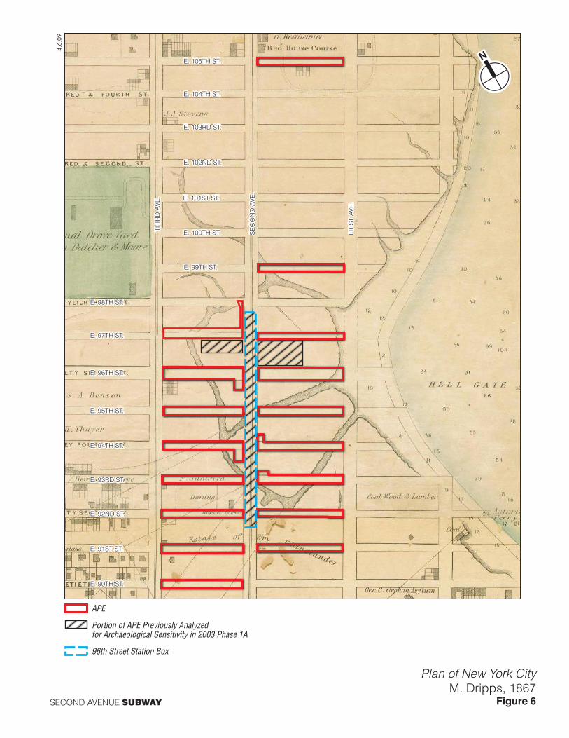
E. 90TH ST.
E. 94TH ST.
E. 95TH ST.
E. 96TH ST.
E. 97TH ST.
THIR
D A
VE
.
SE
CO
ND
AV
E.
FIR
ST
AVE
.
E. 98TH ST.
E. 99TH ST.
E. 100TH ST.
E. 101ST ST.
E. 102ND ST.
E. 103RD ST.
E. 104TH ST.
E. 105TH ST.
E. 91ST ST.
E. 92ND ST.
E. 93RD ST.
SECOND AVENUE SUBWAY
Plan of New York CityM. Dripps, 1867
Figure 6
4.6.
09
APE
Portion of APE Previously Analyzedfor Archaeological Sensitivity in 2003 Phase 1A
96th Street Station Box

E. 90TH ST.
E. 94TH ST.
E. 95TH ST.
E. 96TH ST.
E. 97TH ST.
THIR
D A
VE
.
SE
CO
ND
AV
E.
FIR
ST
AVE
.
E. 98TH ST.
E. 99TH ST.
E. 100TH ST.
E. 101ST ST.
E. 102ND ST.
E. 103RD ST.
E. 104TH ST.
E. 105TH ST.
E. 91ST ST.
E. 92ND ST.
E. 93RD ST.
4.6.09
SECOND AVENUE SUBWAY
SCALE
0 500 1000 FEET
Atlas of the City of New YorkG.W. Bromley, 1891
Figure 7
APE
Portion of APE Previously Analyzedfor Archaeological Sensitivity in 2003 Phase 1A
96th Street Station Box