Embed Size (px)
Citation preview

Mid term pavement condition monitoring
of the rural road surfaces
Eng. Pham Gia Tuan
Local Team Manager
October, 2008
Seacap 27

2
The Seacap 27 project is being carried out by primarily by TRL
Ltd as the Lead Consultants working in association with OtB
Engineering (International) Ltd and TEDI. In additional formal
sub-contracts have been signed with the University of
Transport and Communication (Hanoi) and ITST.
This is part of the wider South East Asia Community Access
Programme (Seacap) that funded by DFID.
It’s concerned with the essential continuation of the RRST
programmes into the vital phases of long term condition
monitoring, analysis and research mainstreaming.
The sustainable application of all the previous phases of trial
road costing, design, construction and short term monitoring is
dependant on a successful completion of this project and the
continuation of the RRSR programme.
The seacap 27 - background

3
Project objectives

4
Demonstrate the suitability of a range rural road pavement
options within the constraints of the Vietnam road environment.
Identify the deterioration characteristics of the pavement
options in order to establish their Whole Life Costs and also to
define the limits of their appropriate usage.
Overall Programme objective

5
An updated and more user-friendly RRSR database
Form links between the completed short term monitoring and future longer term monitoring
An updated RRST cost model
An updated rural road pavement selection procedure
Manual and handover training material associated with items above
Define an institutional home for the RRSR database and research
A comprehensive final report
Key documents posted on relevant website.
objectives

6
Technical background

7
The rural road surfacing trial phase 1 (RRST-I)
The rural road surfacing trial phase 2 (RRST-II)
Triall road lengths were designated either as Trial sections,
Control sections or Training sections
The total lengths of trials roads constructed were, for RRST-I:
5.89km and RRST-II: 121.09km
A total of 12.67km are included in the monitoring programme
with section lengths of between 100m and 200m.
Sections were selected for ongoing performance monitoring
included all trial and control sections of RRST-I and 78 trial
and control sections of RRST-II.
The rrst trial roads

8
The rrst trial roads
Province Constructed
Roads (No.)
Monitored Roads
(No.)
Monitoring section
(No.)
RRST-I
Hue 1 1 7
Tien Giang 1 1 8
Dong Thap 1 1 9
Da Nang 1 1 5
RRST-II
Tuyen Quang 5 2 7
Ha Tinh 6 3 10
Quang Binh 3 2 8
Ninh Binh 10 4 13
Hung Yen 5 4 11
Gia Lai 5 2 9
Dak Nong 1 1 11
Dak Lak 3 3 9

9
rrst-trials monitoring to date
Trail Roads
Completed
Monitoring
I
(As Built)II III IV V VI
May 2005 June 2005 February 2006 July 2006 March 2007 January 2008 June 2008
May 2005 July 2005 January 2006 July 2006 March 2007 January 2008 June 2008
July 2005 July 2005 January 2006 July 2006 March 2007 January 2008 June 2008
Da Nang June 2006 July 2005 March 2007 January 2008 June 2008
Tuyen
Quang
May 2006 July 2006 February 2007 December 2007 May 2008
Ha Tinh June 2006 July 2006 March 2007 January 2008 June 2008
Quang Binh June 2007 July 2006 March 2007 January 2008 June 2008
Ninh Binh May 2006 July 2006 March 2007 December 2007 May 2008
Hung Yen June 2006 July 2006 March 2007 December 2007 May 2008
Gia Lai June 2006 July 2006 March 2007 January 2008 June 2008
Dak Lak June 2006 July 2006 March 2007 January 2008 June 2008
Dak Nong June 2006 July 2006 March 2007 January 2008 June 2008

10
the rrsr database
The RRSR database contains the data files assembled from:
1. RRST-I trials – SEACAP 1
2. RRST-II trials - SEACAP 1
3. RRGAP road condition survey – SEACAP 4
Data from programmes 1 and 3 were collected and assessed
under the direct management of Intech-TRL.
Data from programme 2 were collected and collated by ITST
under a direct contract with SEACAP for which Intech-TRL
had only an overall planning and management role

11
SEACAP 27 activities and
progress

12
Main activities
Formalisation of associations and
development of project relationships
Interim monitoring
Data management

13
development of project relationships
TRL and its associates have been able to quickly
re-established links with the MoT, the RRST
Steering Committee, the Provincial authorities and
other key stakeholders such as World Bank.
Working relationships were also development
with the formal and informal project associates.
Base on the Steering Committee's
recommendation the Vietnam Road Authority (VRA)
has been identified as the most appropriate agency
to be the home institutional of the RRST data.

14
Interim monitoring
The first phase of interim monitoring was undertaken by
SEACAP 27 Team during December 2007 and January 2008.
The second phase was undertaken during May 2008 and
June 2008.
Key points to note with respect to the completion of this
survey are:
PDoT staff involvement in the condition data collection
procures was fully supported by the project.
Data collection procedures followed the recommendation
in the SEACAP 1 guidelines
Two times of 3-day traffic counts were completed on each
of the monitored trial roads in all 12 RRST participating
provinces.

15
Input of recovered survey information
Continue to upgrade the Database
Identification of data analysis and presentation
procedure
data management

16
Input of recovered survey information
All the field data from the first and the second
SEACAP 27 surveys have been entered into the
RRSR database. This has included the
processing of raw DCP and leveling data and
transfer into spreadsheets

17
Continue to upgrade the Database
A review of the database structure has been done
and the second SEACAP 27 surveys data has been
upgraded
The traffic and surface roughness data have been
converted from EXCEL spreadsheet format into the
main ACCESS database thus allowing more efficient
data manipulation

18
Data analysis procedure
Two basic indexes have been established for
assessment of road damage level are Damage Extent
Index (DEI) and road Damage Condition Index.
The DCI: shows the level of damage on each trial
section for a selected set of feature such as rust,
cracks, potholes, brick condition etc (This features
vary with pavement type).
The DEI shows the percentage of the trial road
sections that show any damage in the selected set of
features.

19
Data analysis procedure and presentation
20
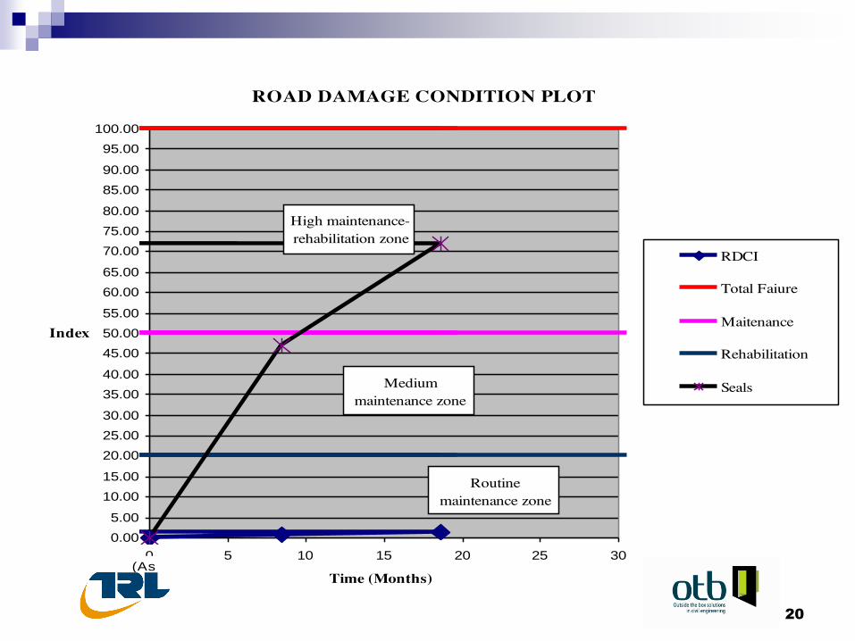
road damage condition plot
0.00
5.00
10.00
15.00
20.00
25.00
30.00
35.00
40.00
45.00
50.00
55.00
60.00
65.00
70.00
75.00
80.00
85.00
90.00
95.00
100.00
0 5 10 15 20 25 30
Time (Months)
Index
RDCI
Total Faiure
Maitenance
Rehabilitation
Seals
(As
High maintenance-
rehabilitation zone
Medium
maintenance zone
Routine
maintenance zone

21
Data Analysis Outputs
Taken together the Damage Extent Index (DEI)
and Road Damage Condition Index (RDCI) are
being used to establish the relative
performance of the RRST trial pavements in a
range of Vietnam road environments.
They can also be used to establish the relative
maintenance needs of the various options and
hence also provide an input to their relative
Whole Life Costs
22
thank you !
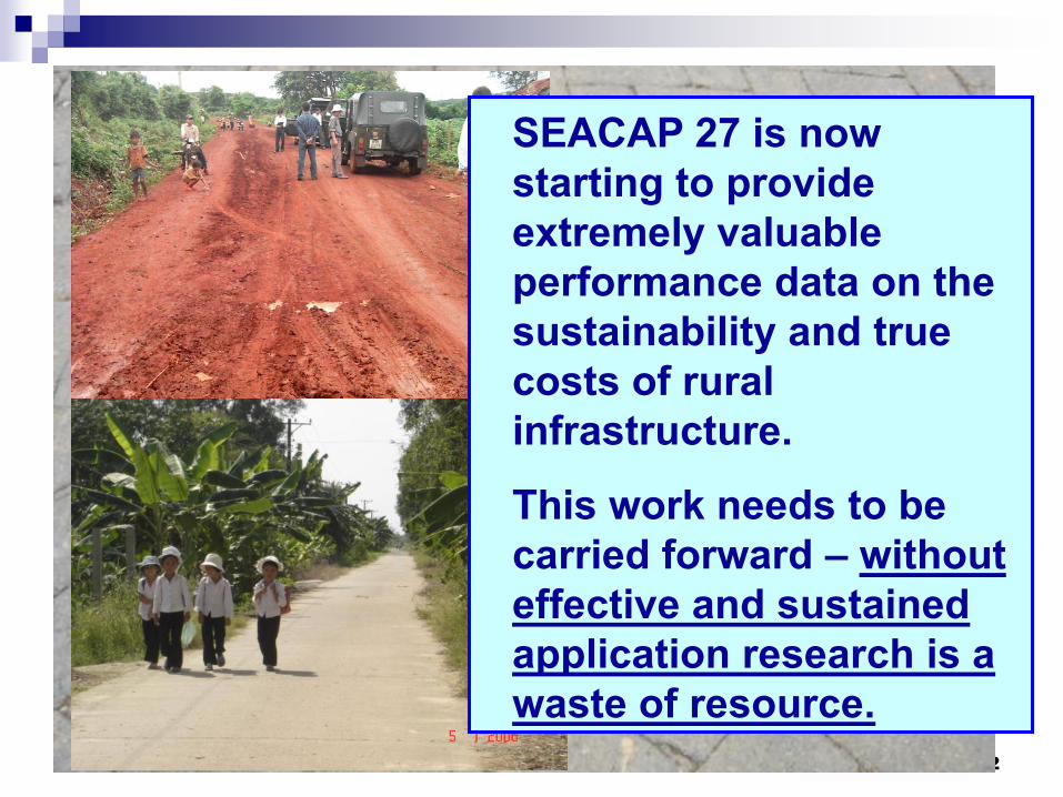
SEACAP 27 is now
starting to provide
extremely valuable
performance data on the
sustainability and true
costs of rural
infrastructure.
This work needs to be
carried forward – without
effective and sustained
application research is a
waste of resource.