Embed Size (px)
Citation preview

School of GeographyFACULTY OF ENVIRONMENT
Introduction to ArcGIS

Introductions
• Does everyone have ArcGIS on their desktops?
• Who uses ArcGIS regularly?
• If so, what is your main use of GIS?
• What would you like to be able to do?

What is GIS?
• Many definitions available
• System for display, storage, mapping, analysis of spatial data
• Many acronyms for GIS
• Geographic Information Systems
• Geographic Information Science
• Body of Knowledge
• Geographic Information Services, etc.

History of ArcGIS
1969Jack Dangermond
founds ESRI
1982Arc/INFO (Unix)
1989 PC Arc/INFO (DOS + Windows)
1992ArcView + Arc/INFO
2002ArcView 3.3
“retired product”
1999 ArcGIS v.8.0
(to v8.3)
2004ArcGIS v.9.0
2008ArcGIS v.9.3

Overview of Applications
ArcGIS Desktop
ArcGIS Server
ArcSDE
ArcIMS
ArcGIS Mobile
ArcPad
ArcGIS Engine
ArcObjects
ArcReader
ArcGIS Explorer
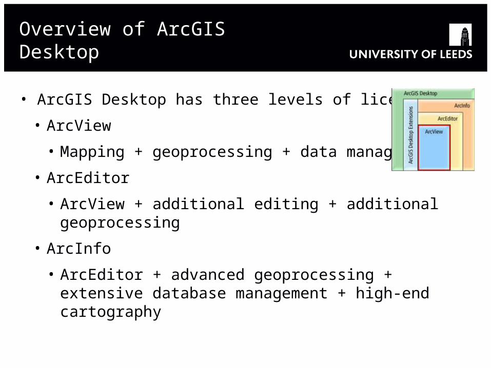
Overview of ArcGIS Desktop
• ArcGIS Desktop has three levels of licensing:
• ArcView
• Mapping + geoprocessing + data management
• ArcEditor
• ArcView + additional editing + additional geoprocessing
• ArcInfo
• ArcEditor + advanced geoprocessing + extensive database management + high-end cartography

ArcGIS Desktop Components
• ArcCatalog
• ArcMap
• ArcToolbox
• Extensions
• 3D Analyst, Spatial Analyst, Network Analyst, Geostatistical Analyst, Crime Analyst, ArcGIS Schematics, Business Analyst, PLTS, Data Interoperability, Tracking Analyst, ArcGIS Publisher, Survey Analyst, ArcScan (included with ArcEditor license), Maplex (included with Arcinfo license)
http://www.esri.com/software/arcgis/about/desktop_extensions.html
http://support.esri.com/index.cfm?fa=software.extentions

Data Models - 1
• How we represent real world spatial phenomena
• Two main models:
• Vector
• Points (single x,y coordinate)
• Lines (strings of x,y coordinates)
• Polygons (closed string of x,y coordinates)
• Raster
• A grid of (often) square-shaped cells
• Individual cells together are used to create a layer of points, lines and areas

Data Models - 2
• Other models:
• Surfaces for 3D visualisation
• Networks (geometric, transportation)
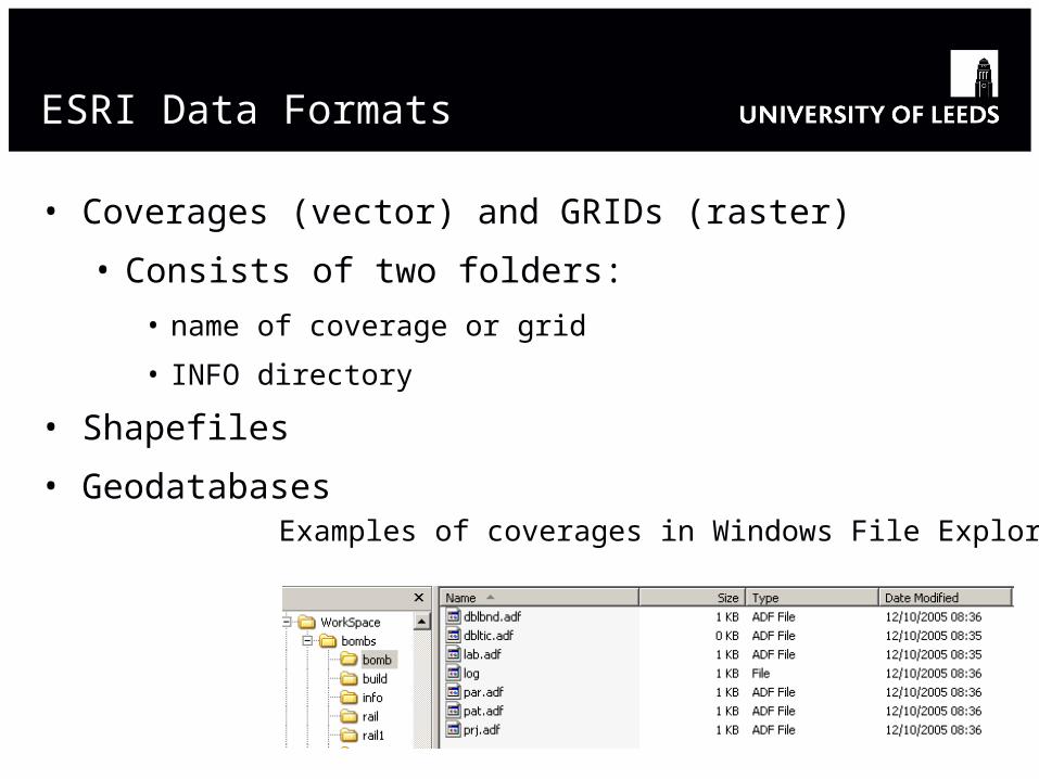
ESRI Data Formats
• Coverages (vector) and GRIDs (raster)
• Consists of two folders:
• name of coverage or grid
• INFO directory
• Shapefiles
• GeodatabasesExamples of coverages in Windows File Explorer

Shapefiles
<filename>.shp stores the spatial or feature information
<filename>.dbf dBASE file contains attribute information about the spatial features
<filename>.shx stores the index of the features
<filename>.sbn stores the spatial index of features
<filename>.sbx also stores information pertaining to the spatial index of features
<filename>.prj contains projection information

Geodatabases
• Core ArcGIS data model• A comprehensive model for representing and managing geographic data
• Personal Geodatabase• Single user editing / multiple readers• Stored in MS Access• Size limit of 2 GB
• File Geodatabase• Single user editing / multiple readers• 1 TB per table• Reduced storage requirements
• ArcSDE Geodatabase • Stored in an Enterprise DBMS• Supports multiuser editing via versioning• Requires ArcEditor or ArcInfo to edit
ArcGIS
Personal
Geodatabase
File
Geodatabase
ArcSDE
Geodatabase
Oracle
SQL Server
DB2
Informix
PostgreSQL
ArcSDE

ArcCatalog
• these formats are comprised of many files so you need a GIS data management system

The ArcCatalog Interface
5 Dockable toolbars
7 Geography Preview Mode
1 Title bar 4 Standard toolbar
6 Catalog
Tree
(navigation)
3 Metadata
toolbar
2 Location
toolbar

Catalog Tree
• Icons identify data types
• Right-click of a context menus
• Supports drag, drop, copy, paste
• Displays folder connections
• Displays other connections
• ArcSDE databases
• Web servers (internal, ESRI)Context
menu
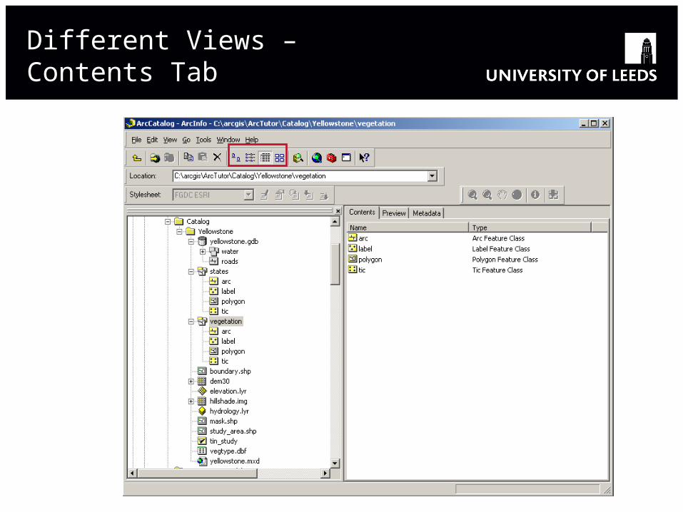
Different Views – Contents Tab
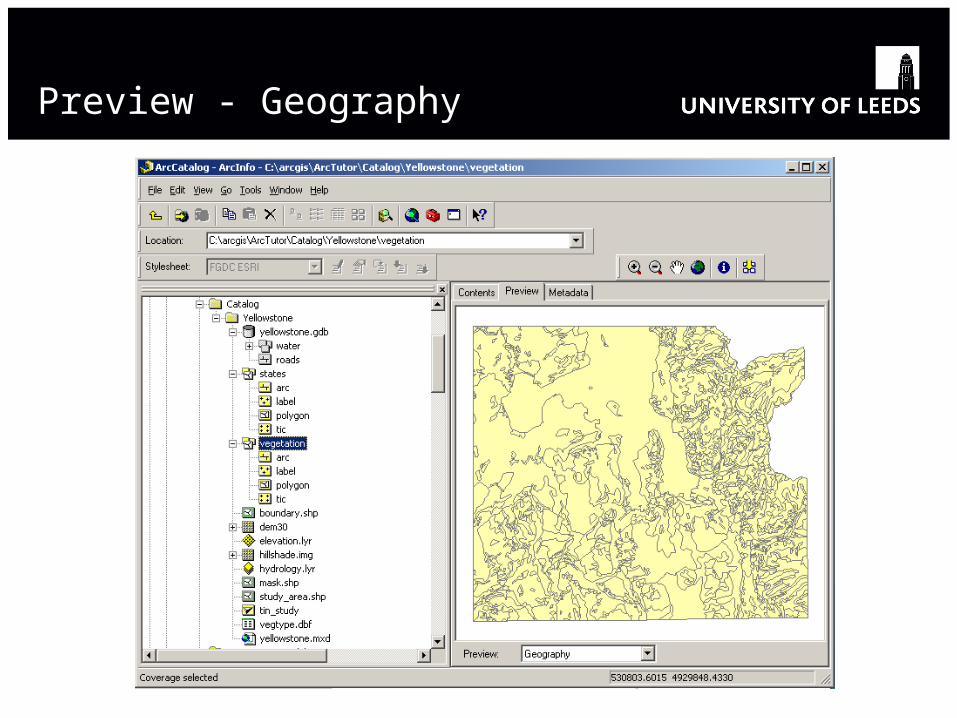
Preview - Geography

Preview - Table View

Metadata View

Management tasks
• Copy, paste, delete, rename data
• Move to other locations
• Create new objects
• Connect to folders

Searching for Data
• Edit Search
• can search for geography or metadata
• can search using different parameters
• Name + physical location
• Geography
• Date
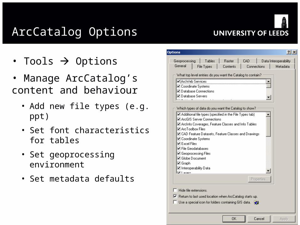
ArcCatalog Options
• Tools Options
• Manage ArcCatalog’s content and behaviour
• Add new file types (e.g. ppt)
• Set font characteristics for tables
• Set geoprocessing environment
• Set metadata defaults
Metadata
• Descriptive information about data
• Content
• Quality
• Condition
• Origin
• Other characteristics
• But do you really need it?
• All GIS resources need metadata
• Spatial data
• Non-spatial data
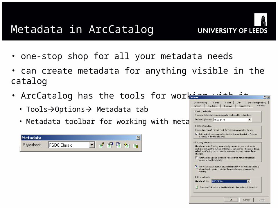
Metadata in ArcCatalog
• one-stop shop for all your metadata needs
• can create metadata for anything visible in the catalog
• ArcCatalog has the tools for working with it
• ToolsOptions Metadata tab
• Metadata toolbar for working with metadata

Metadata Components
• Documentation: metadata elements the user can edit
• Abstract
• Purpose
• Use constraints
• Etc.
• Properties: elements that update automatically
• Names and types of attributes
• Coordinate system information
• Bounding coordinates
• Etc.

Metadata Standards
• GEMINI v.2.1 is the UK metadata standard (Oct 2007)
• based on ISO19115
• to meet the requirements for metadata of the EU INSPIRE Directive
http://www.gigateway.org.uk/metadata/standards.html

Create and update metadata
• Automatically
• Created first time an item’s metadata is viewed
• Updated whenever metadata is viewed in metadata tab
• Edit metadata button
• Manually
• Tools Options Metadata tab
• Create / Update metadata button
• Choose your stylesheet here

Metadata Editor

More Information on Metadata
• Sample code or custom applications to automate metadata production from the ESRI Developer Network
• http://edn.esri.com – find resources for ArcGIS 9.2 and prior and in Code Exchange, enter “metadata”)
• Metadata SpellChecker
• Edit Metadata in ArcMap
• Create Metadata for All in Folder
• Metadata Quick Editor (executable file)
• Template Exporter
• Etc.

In Summary
ArcCatalog allows you to:
• Browse, manage and find spatial data
• Record, view and manage metadata
• Search for GIS data on local drives, networks and the Web
• Define, import and export geodatabases and other datasets
• Create and manage the schemas of geodatabases
• Administer ArcSDE geodatabases
• Administer an ArcGIS server
An Introduction to ArcCatalog
Hands-on Exercise #1

The ArcMap Interface
4 Standard
Toolbar
1 Table of
Contents
6 Drawing
Toolbar
2 Map Display
5 Tools
Toolbar
3 Main Menu Toolbar

Adding Layers
• Use the Add Data button
• Search for data in ArcCatalog and slide the data into ArcMap

Right-click: Context Menu

Tools Toolbar
Zoom outZoom in
Pan Go to full extent
Zoom out to a fixed extentZoom in to a fixed extent
Go to previous extent Go to next extent
Measure
Clear selected features
Select elements Identify
Find
Select features
Go to X-Y coordinate
Hyperlink

An Introduction to ArcMap
Hands-on Exercise #2