Embed Size (px)
Citation preview
1
BABEŞ-BOLYAI UNIVERSITY
FACULTY OF GEOGRAPHY
Doctoral Thesis
(Abstract)
GEOMORPHOLOGICAL DYNAMICS OF THE
TORRENTIAL SYSTEMS IN THE SOMEŞ PLATEAU
Scientific Supervisor: PhD Candidate:
Professor Ioan MAC, PhD Florin – Ionuţ COVACIU
CLUJ-NAPOCA
2010
2
Table of Contents
1. Preliminary issues
1.1. Working methodology/7
1.2. Brief history of research into the field/11
1.2.1. Relevant Romanian literature/13
1.2.2. Relevant international literature/15
2. Geo-identity of the Someş Plateau/17
2.1. Location into the Transylvanian Depression. Subdivisions/17
2.2. Brief history of research on the Someş Plateau/22
2.3. Palaeogeography of the Someş Plateau/31
2.3.1. Palaeogeographical evolution of the Someş Plateau /31
2.3.2. Formation and evolution of the hydrographic network in the Someş
Plateau/38
2.3.3. Morphostructure and morpholithology of the Someş Plateau/45
3. Morphology, morphometry and hydrology of torrents/49
3.1. Morphology of torrents/49
3.1.1. Torrents/49
3.1.2. The concept of torrential phenomenon and process/53
3.1.3. Torrential geomorphological systems – open systems/55
3.1.4. Torrents as dissipative structures/57
3.1.5. Sensitivity of torrential geomorphological systems/57
3.1.6. Self-projection in torrential geomorphological systems/58
3.1.7. Evolution of torrents/61
3.1.8. Typology of torrents/66
3.1.9. Classification of torrents/67
3.1.10. Morphology of torrents/69
3.1.11. Thalweg – expression of cooperation between the morphological parts of
the torrent/71
3.1.12. Torrential brook/73
3.2. Morphometry of torrential basins/74
3.2.1. Morphometry of the hydrographic basin/74
3.2.2. Morphometry of the hydrographic network/82
3
3.3. Hydrology of torrential basins/85
3.3.1. Torrential rain/85
3.3.2. Surface retention /91
3.3.3. Water infiltration into soil/95
3.3.4. Surface runoff/97
3.3.5. Maximum flood flows/98
3.3.6. Transport of alluvia/103
4. Control factors of torrentiality in the Someş Plateau/111
4.1. Time/112
4.2. Climate/114
4.3. Relief/123
4.4. Vegetation and its role in the emergence and evolution of torrents/137
4.5. Human factor, by land use and vegetation cover change/142
4.6. Geological substratum and soils/146
5. Torrential phenomenon in the Someş Plateau/161
5.1. Torrential process in the context of the current slope processes/161
5.2. Spatial manifestation of the torrential phenomenon/168
5.3. Inventory of degraded lands in the Someş Plateau/176
5.4. Torrent dynamics in the Someş Plateau/188
6. Management of torrential phenomenon in the Someş Plateau/210
6.1. Torrent planning – a necessity to mitigate hazards and risks/210
6.2. Classification of works used in torrential basin planning /217
6.3. Planning works in torrential hydrographic basins/219
6.4. Importance of maintenance and monitoring of torrent planning works/234
6.5. Benefits of planning works in torrential hydrographic basins/237
6.6. Torrent planning, basic link in the restoration of environmental balance/244
6.7. Planning models for torrential formations in the Someș Plateau/247
6.7.1. Ciorgăuaşu ravine planning model/247
6.7.2. Cetan torrent planning model/252
Conclusions/259
Bibliography/266
4
Key words: dynamic geomorphology, direct erosion, headward erosion,
accelerated erosion, intrinsic dynamics, flood, alluvial fan, rills, gullies, ravines, torrents,
torrential systems, neotectonic movements, risks, hazards, management, torrential
process.
1. Preliminary issues
The issues addressed in this paper are of general interest, not just specific to the
geomorphological field.
Torrents represent distinct forms in the morphology of the Someş Plateau and
their detailed geomorphological analysis (starting from the identification of the control
factors up to the dynamic manifestation) represents a good starting point in elaborating
some risk maps, but especially in choosing the best solutions for managing this
phenomenon at the level of the entire analysed unit.
The working methodology is presented in the first chapter (as result of the
harmonious combination of the methodological principles, work methods, and work
techniques), which allowed to obtain relevant scientific results.
2. Geo-identity of the Someş Plateau
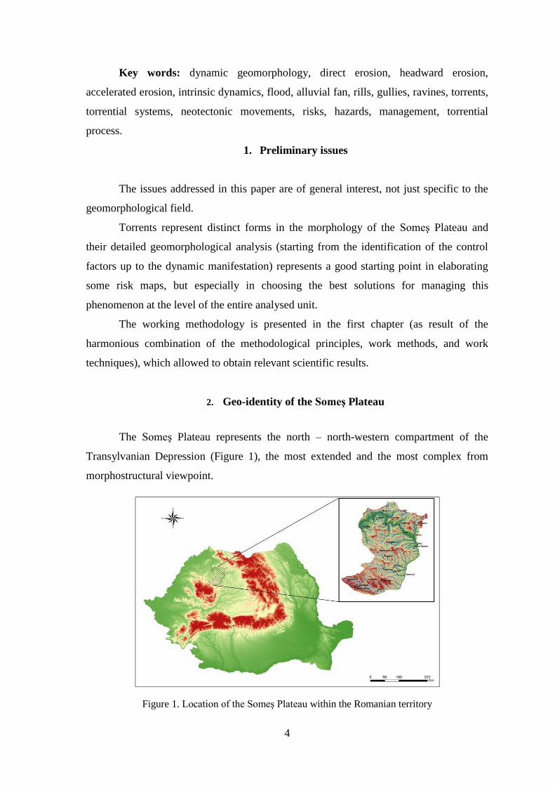
The Someş Plateau represents the north – north-western compartment of the
Transylvanian Depression (Figure 1), the most extended and the most complex from
morphostructural viewpoint.
Figure 1. Location of the Someş Plateau within the Romanian territory
5
The analysis of the palaeogeographical evolution of the Someş Plateau (by means of
the existing geological, geomorphological works and by studying the cartographic
materials) represents a compulsory stage in understanding the context in which the
torrential phenomenon emerged and developed. The current processes shaping the slopes
(including torrentiality) act on the “memory” of the Pleistocene morphostructural system
under the impulse of the human intervention and of the current temperate conditions.
In this region, intense erosion is the result not only of the combined action of the
two neotectonic movements (the rise of the hilly compartment and the local subsidence
of Jibou), but also of the friability of the geological formations.
3. Morphology, morphometry and hydrology of torrents
The understanding of the geomorphological dynamics in torrential systems
requires a good knowledge of torrents as regards their morphology, morphometry and
hydrology. Torrents are the result of the hydro-geomorphological balance, rainfall regime
and relief representing the leading factors whose association creates a favourable context
for the production of surface runoff and the quick concentration of waters in the torrent
beds, triggering torrential phenomena. The difference in elevation dictates the magnitude
of the evolution and the development of a torrent, the decrease in the potential difference
leading to its self-annihilation. Torrents have a permanent tendency towards dynamic
equilibrium, the existing disequilibrium tending towards a new stage of equilibrium, even
during the increase of the formation.
4. Control factors of torrentiality in the Someş Plateau
Geology, topography, climate, vegetation, soils, human factor, time represent the
control factors of torrentiality in the Someş Plateau, which determine the changes and the
feedback relations at the entry into the torrential geomorphological system.
The longitudinal profiles of the torrential valleys in this unit correspond (in terms
of genesis and evolution) to a sequence of the geologic time (i.e. geomorphological
time), being the expression of the co-working between the control factors: initial relief,
climate (extremes, average precipitation), geology (great extension of the friable rocks,
alternation of hard and soft rocks, tectonic movements) etc.
6
Climate represents one of the independent variables of the torrential
geomorphological system, with great impact in the development of the torrential
geomorphological processes by the regime and the variations of precipitation and
temperature, generating floods.
Relative altitude represents a very good indicator of the intensity of torrential
processes, as well as of the evolution trend of the torrential formations. The highest
frequency of these formations corresponds to the Someş Corridor, being correlated with
the areas of maximum energy highlighted in the following sectors: Căpâlna – Gâlgău –
Dăbâceni (north of the Someş Corridor) and Rus – Vad (in the south).
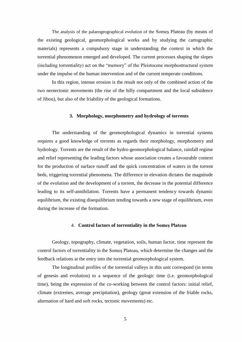
Out of the total area of the Someş Plateau (2,621.4 km²), only 749.9 km² are
covered by forest. Forests are preserved in patches, forest soils standing testimony of the
former forest cover. A high degree of forested areas is highlighted on the slopes
bordering the Someş Corridor, the presence of the forest cover having impact in slowing
down the torrential processes, despite the high value of the relative altitude. However, at
unit level, the degree of slope forests remains very low (Figure 2), fact reflected in the
high density of the sheet and gully erosion.
Figure 2. Forested areas in the Someş Plateau
The high frequency of defective works applied to lands, overgrazing, erased or
quasi-erased woodcutting, etc., without taking into account the implications upon the
7
erosion processes in the basin, represents a part of the causes that favour the rapid
concentration of runoff, the development and the progress at an intense pace of the
torrential processes, as well as the association with other slope processes (landslides,
rock falls etc.).
Land use and the modification of the vegetation cover structure represented
primordial causes that favoured sheet and gully erosion. This can be seen clearly from the
large area of degraded lands in the Someş Plateau (62,683.2 ha).
The greatest share belongs to sheet erosion, which, at the level of the Cluj and Dej
Hills, affects 15,131.4 ha, and at the level of the Şimişna-Gârbou Hills affects 10,624 ha,
subunits in which forests cover very restricted areas. The areas of land affected by gully
erosion (rills, gullies, ravines) are lower compared with those affected by sheet erosion,
being of 2,166.2 ha in the Cluj and Dej Hills and of 1,533.4 ha in the Şimişna-Gârbou
Hills.
Geology represents another independent variable of the torrential
geomorphological system. The lower relative altitude (about 100 m) in the Cluj and Dej
Hills, combined with the high friability of rocks, has generated torrents with large cross
sections, at the level of each morphological unit. Exceptions occur in the case of torrents
that have suffered geological constraints in their development, constraints imposed by the
presence of Eocene tuff and limestone.
In the Şimişna–Gârbou Hills, the prevalence of Miocene formations (consisting of
clays, with intercalations of sandstones, kaolin sands, conglomerates) have created a
geological background favourable for torrential processes because of the low resistance
to erosion of the existing rocks, besides the above-mentioned variables.
The Purcăreţ-Boiul Mare Plateau highlights torrential rills, deepened in the
Oligocene sediments and, subsequently, in the Eocene limestone in the base. Some of
them disappear in the limestone, emerging at lower altitudes. In addition, the presence of
limestone and sandstone thresholds have forced some torrents (such as the Scandicu
torrent) to shape a klisura-like channel that ensures the transport of the material from the
catchment basin, suspended and extended in area, towards the sector of lower slope
gradients.
In the Sălătruc Hills, the friability of the Miocene deposits (carbonate clays,
sands, gravels) has allowed the torrential formations to evolve quickly, developing large
cross sections (the Runc torrent, south of the village of Gostila, the Cupşoara torrent,
8
west of Chiuieşti), while the Dej tuff generates steep slopes and frequent slope breaks in
the longitudinal profiles of the previously-mentioned torrents.
The geologic substratum influences both the torrential morphodynamics and the
evolution of the forms in the valley complex. In the hard rocks, the evolution of torrents
is a more reduced one, being the morphodynamic response given by the resistance of the
respective strata to erosion. The typical morphology of the Usturiş, Răpău, Chejd torrents
can be mentioned, where the emergence of hard rocks (limestone, tuffs) have conditioned
constraints in the evolution of torrents, clear delimitations between some morphological
parts of the torrents, as well as a typical physiognomy (suspended catchment basin, drain
channel, which, on certain sectors, has the form of local petrographic scarp).
5. Torrential phenomenon in the Someş Plateau
The chapter highlights the place of the torrential process in the context of current
slope processes, the spatial manifestation of the torrential phenomenon, the inventory of
degraded lands (by gully erosion, sheet erosion and landslides, processes that coexist and
complete each other on large areas) in the geographical unit under consideration, as well
as of the torrent dynamics in the area.
Torrential valleys are the answer of the genetic-evolutionary process. The change
of the rapport: vertical erosion – lateral erosion – accumulation reflects the evolutionary
stage of the torrent, imprinting the overall morphology of valleys.
The active forms of these torrential modelling formations (rills, gullies, ravines,
torrents) appear frequently in the four subunits, in response to the large amounts of
precipitation that allow the formation of floods, relative attitude, friability of rocks,
changes in vegetation cover structure, etc.
Torrents with complex geometry (classical model) present the highest frequency
in the entire unit, the northern slopes of the Dej Hills and the Şimişna-Gârbou Hills
(towards the Someş Corridor) being the most affected by vigorous torrents proper, as
result of the high relative altitude, whose brutal manifestation is illustrated by the
materials transported by debris flows and deposited in the outlet section (Photo 1).
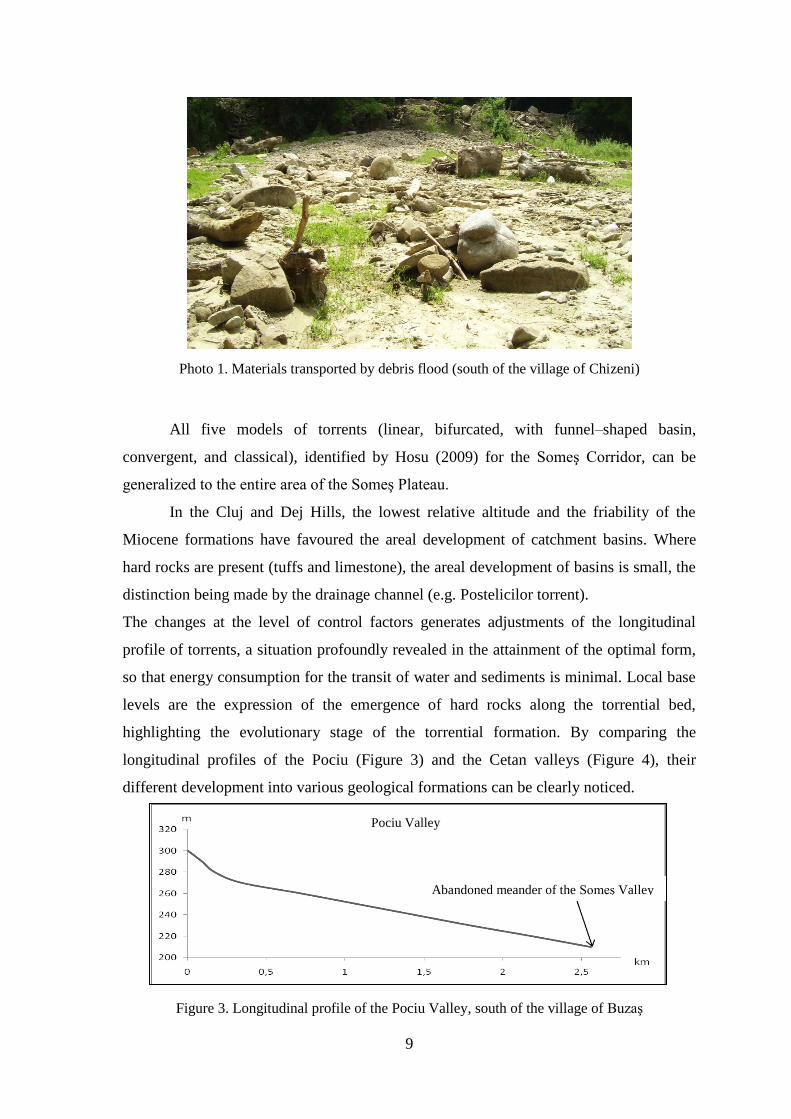
9
Photo 1. Materials transported by debris flood (south of the village of Chizeni)
All five models of torrents (linear, bifurcated, with funnel–shaped basin,
convergent, and classical), identified by Hosu (2009) for the Someş Corridor, can be
generalized to the entire area of the Someş Plateau.
In the Cluj and Dej Hills, the lowest relative altitude and the friability of the
Miocene formations have favoured the areal development of catchment basins. Where
hard rocks are present (tuffs and limestone), the areal development of basins is small, the
distinction being made by the drainage channel (e.g. Postelicilor torrent).
The changes at the level of control factors generates adjustments of the longitudinal
profile of torrents, a situation profoundly revealed in the attainment of the optimal form,
so that energy consumption for the transit of water and sediments is minimal. Local base
levels are the expression of the emergence of hard rocks along the torrential bed,
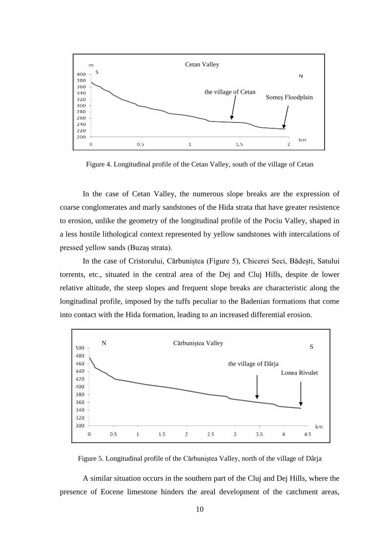
highlighting the evolutionary stage of the torrential formation. By comparing the
longitudinal profiles of the Pociu (Figure 3) and the Cetan valleys (Figure 4), their
different development into various geological formations can be clearly noticed.
Figure 3. Longitudinal profile of the Pociu Valley, south of the village of Buzaş
Pociu Valley
Abandoned meander of the Someş Valley
10
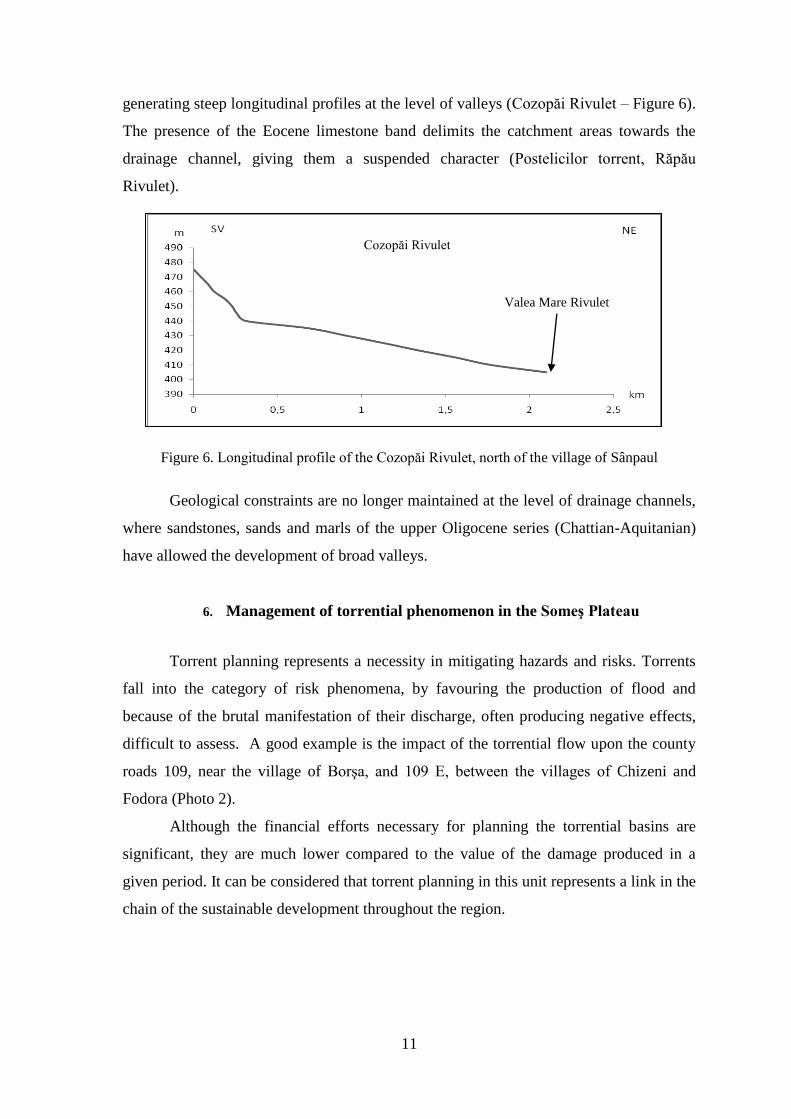
Figure 4. Longitudinal profile of the Cetan Valley, south of the village of Cetan
In the case of Cetan Valley, the numerous slope breaks are the expression of
coarse conglomerates and marly sandstones of the Hida strata that have greater resistence
to erosion, unlike the geometry of the longitudinal profile of the Pociu Valley, shaped in
a less hostile lithological context represented by yellow sandstones with intercalations of
pressed yellow sands (Buzaş strata).
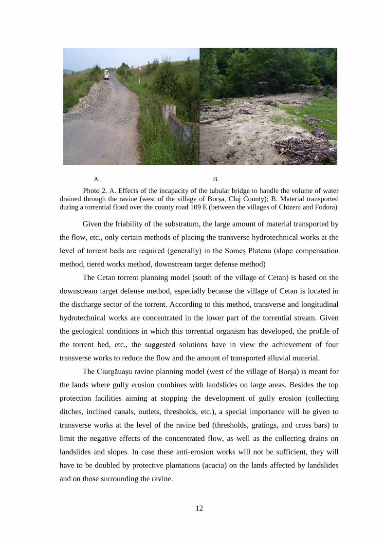
In the case of Cristorului, Cărbuniştea (Figure 5), Chicerei Seci, Bădeşti, Satului
torrents, etc., situated in the central area of the Dej and Cluj Hills, despite de lower
relative altitude, the steep slopes and frequent slope breaks are characteristic along the
longitudinal profile, imposed by the tuffs peculiar to the Badenian formations that come
into contact with the Hida formation, leading to an increased differential erosion.
Figure 5. Longitudinal profile of the Cărbuniştea Valley, north of the village of Dârja
A similar situation occurs in the southern part of the Cluj and Dej Hills, where the
presence of Eocene limestone hinders the areal development of the catchment areas,
the village of Cetan Someş Floodplain
Cetan Valley
Cărbuniştea Valley
the village of Dârja
Lonea Rivulet
N S
11
generating steep longitudinal profiles at the level of valleys (Cozopăi Rivulet – Figure 6).
The presence of the Eocene limestone band delimits the catchment areas towards the
drainage channel, giving them a suspended character (Postelicilor torrent, Răpău
Rivulet).
Figure 6. Longitudinal profile of the Cozopăi Rivulet, north of the village of Sânpaul
Geological constraints are no longer maintained at the level of drainage channels,
where sandstones, sands and marls of the upper Oligocene series (Chattian-Aquitanian)
have allowed the development of broad valleys.
6. Management of torrential phenomenon in the Someş Plateau
Torrent planning represents a necessity in mitigating hazards and risks. Torrents
fall into the category of risk phenomena, by favouring the production of flood and
because of the brutal manifestation of their discharge, often producing negative effects,
difficult to assess. A good example is the impact of the torrential flow upon the county
roads 109, near the village of Borşa, and 109 E, between the villages of Chizeni and
Fodora (Photo 2).
Although the financial efforts necessary for planning the torrential basins are
significant, they are much lower compared to the value of the damage produced in a
given period. It can be considered that torrent planning in this unit represents a link in the
chain of the sustainable development throughout the region.
Cozopăi Rivulet
Valea Mare Rivulet
12
A. B.
Photo 2. A. Effects of the incapacity of the tubular bridge to handle the volume of water
drained through the ravine (west of the village of Borşa, Cluj County); B. Material transported
during a torrential flood over the county road 109 E (between the villages of Chizeni and Fodora)
Given the friability of the substratum, the large amount of material transported by
the flow, etc., only certain methods of placing the transverse hydrotechnical works at the
level of torrent beds are required (generally) in the Someş Plateau (slope compensation
method, tiered works method, downstream target defense method)
The Cetan torrent planning model (south of the village of Cetan) is based on the
downstream target defense method, especially because the village of Cetan is located in
the discharge sector of the torrent. According to this method, transverse and longitudinal
hydrotechnical works are concentrated in the lower part of the torrential stream. Given
the geological conditions in which this torrential organism has developed, the profile of
the torrent bed, etc., the suggested solutions have in view the achievement of four
transverse works to reduce the flow and the amount of transported alluvial material.
The Ciurgăuaşu ravine planning model (west of the village of Borşa) is meant for
the lands where gully erosion combines with landslides on large areas. Besides the top
protection facilities aiming at stopping the development of gully erosion (collecting
ditches, inclined canals, outlets, thresholds, etc.), a special importance will be given to
transverse works at the level of the ravine bed (thresholds, gratings, and cross bars) to
limit the negative effects of the concentrated flow, as well as the collecting drains on
landslides and slopes. In case these anti-erosion works will not be sufficient, they will
have to be doubled by protective plantations (acacia) on the lands affected by landslides
and on those surrounding the ravine.

13
Conclusions
In the analysed unit, climate, geology, topography, vegetation, as well as human
factor (by land use and vegetation cover change), create a very favourable context for the
manifestation of torrential processes and the development of torrential formations. The
friability of rocks, the relative altitude, etc., offered by the Someş Plateau, have
determined the development of some vigorous torrents that have shaped the slopes
intensely (by erosion), evolving up to the formation of some micro-depressions
(Luminişu, Bădeşti, Poieniţa, etc.).
The torrential process is the answer of the mutual interactions and conditionings
between erosion, transport and accumulation, each of them representing a main facet of
this unique process. Within torrential formations, erosion takes place both directly and
regressively. The force that gives a strong dynamics to the entire torrential process is
represented by flood, whose level is essential. Its action depends very much on the
strength of materials and the morphometric elements. The energy dissipation of the
torrent is achieved where the amount of deposited materials oppose a sufficient resistance
against transport.
The torrent resists as long as it has intrinsic energy which is related to water and
strength of materials.
The management of the torrential phenomenon in the Someş Plateau represents
the practical side of the present research. The planning of the torrential hydrographic
basins, through its multiple beneficial effects (economic, social, etc.), represents a link in
the chain that leads towards a sustainable development of the entire unit under
consideration. The functional reintegration of the lands affected by torrential processes
into environment depends on the combined and complete implementation of works
(transverse, longitudinal, slope runoff regulation, afforestation), so that the final result is
maximum, with as little financial efforts as possible.
14
SELECTED BIBLIOGRAPHY
1. Abagiu, P., Bumbu, Gh., Munteanu, S.A., Moja, Gh., Lazăr, N., (1980), Determinarea
parametrilor hidrologici ai pădurii în raport cu modul de gospodărire, scurgerea de
suprafaţă şi intercepţia în coronament, în arboretele de fag şi molid. I.C.A.S., Seria a II-
a, Bucureşti.
2. Arghiriade, C., (1968), Cercetări privind capacitatea de retenţie a apei în culturile tinere de
protecţie de pe terenurile degradate. Centrul de Documentare Tehnică pentru Economia
Forestieră, Bucureşti.
3. Armaş, Iuliana (1998), Geomorfologie experimentală, concept şi metodă, Analele Universităţii
Spiru Haret, Seria geografie, nr. 1.
4. Armaş, Iuliana (2000), Evoluţia reliefului din perspectiva dinamicii neliniare, Terra, nr. 2,
Bucureşti.
5. Armaş, Iuliana (2006), Risc şi vulnerabilitate: metode de evaluare aplicate în geomorfologie,
Edit. Universităţii din Bucureşti, Bucureşti.
6. Bădescu, Gh. (1972), Ameliorarea terenurilor erodate. Corectarea torenţilor. Combaterea
Avalanşelor, Editura Ceres, Bucureşti.
7. Bălteanu, D., Dragomirescu, S., Muică, Cristina, (1985), Cercetări geomorfologice pentru
lucrările de îmbunătăţiri funciare, Univ. Bucureşti, Institutul de geografie, Institutul de
studii şi proiectătări pentru îmbunătăţiri funciare, Bucureşti.
8. Bătuca, D. (1986), Principii variaţionale în studiul transportului aluvionar, Lucrările
Simpozionul„Provenienţa şi efluenţa aluviunilor”, nr.1.
9. Bechet, S., Neagu, Ileana, (1975), Amenajarea şi exploatarea antierozională a terenurilor în
pantă, Editura Scrisul românesc, Craiova.
10. Blaga, L., Rus, I. (2004), Alometria şi controlul lateral al bazinelor hidrografice, Studia
Univ.”Babeş-Bolyai ”, Seria Geographia, an XLIX, nr. 1, Cluj-Napoca.
11. Brunsden, D. (2001), A critical assessment of the sensitivity concept in geomorphology,
Catena, nr. 42, Elsevier.
12. Chorley, R. J., Haggett, P. (1969), Phiysical and Information Models in Geograpphy,
University Paperbacks, Methuen, London.
13. Chorley, R. J., Kennedy, B. A. (1984), Physical Geography. A System Aproach, Prentince
Hall Int., London.
14. Ciupagea, D., Paucă, M., Ichim, Tr. (1970), Geologia Depresiunii Transilvaniei, Edit.
Academiei, Bucureşti.
15. Clinciu, I. (1980) Orientări moderne în domeniul morfometriei bazinelor hidrografice
torenţiale. În Revista Pădurilor, nr. 4 Bucureşti.
16. Clinciu, I., Lazăr N. (1992) Corectarea torenţilor. Universitatea Transilvania din Braşov.
17. Clinciu, I., Lazăr N., (1997) : Lucrări de amenajare a bazinelor hidrografice torenţiale.
Editura Didactică şi Pedagogică, Bucureşti.
18. Clinciu I., (2001), Corectarea torenţilor – curs universitar. Ediţia a II-a, Reprografia
Universităţii Transilvania din Braşov, Braşov. 19. Cocean P., Schreiber W., Cocean Gabriela (2009), The Someş Plateau – Regional Identity, în
Romanian Review of Regional Studies, Volume V, Number 1, Cluj-Napoca. 20. Covaciu, F.I., (2005), Senzitivitatea geomorfologică în defileul Benesat-Ţicău. Lucrările
Simpozionului Ştiinţific: Ştiinţă şi Dezvoltare în Profil Teritorial, Baia Mare 27-28 mai
2005, Edit. Risoprint, Cluj-Napoca.
21. Croitoru Adina-Eliza (2006), Excesul de precipitaţii din Depresiunea Transilvaniei, Editura
Casa Cărţii de Ştiinţă, Cluj Napoca.
22. Croke, J., Mockler, S., Fogarty, P., Takken, Ingrid (2005), Sediment concentration changes in
runoff pathways from a forest road network and the resultant spatial pattern of
catchment connectivity, Geomorphology, 68, Elsevier.
23. Eaton, B. C., Millar, R. G. (2004), Optimal alluvial channel width under a bank stability
constraint, Geomorphology, 62, Elsevier.
15
24. Ferguson, R. I. (2005), Estimating critical stream power for bedload transport calculations in
gravelbed rivers, Geomorphology, 70, Elsevier.
25. Frevert, R.K., Schwab, G., (1955), Soil and water conservation engineering.The Ferguson
fundation agricultural engineering series.
26. Gaspar, R., Costin, A., Clinciu, I., Lazăr, N., (1995), Amenajarea bazinelor hidrografice
torenţiale. În volumul Protejarea şi dezvoltarea durabilă a Pădurilor României, editat de
Societatea Progresul Silvic (sub redacţia: V. Giurgiu), Editura Arta Grafică, Bucureşti.
27. Gaspar, R., Untaru, E., Roman, F., Cristescu, C., 1981: Cercetări asupra precipitaţiilor,
scurgerii de suprafaţă şi eroziunii în bazine hidrografice torenţiale. În Revista Pădurilor,
nr. 6, Bucureşti.
28. Gaspar, R., Cristescu, C., Roman, F. (1986), Cercetări asupra provenienţei şi transportului
de aluviuni în bazine hidrografice mici torenţiale, Lucrările Simpozionul „Provenienţa şi
efluenţa aluviunilor”, nr.1.
29. Gârbacea, V. (1961), Consideraţii cu privire la evoluţia reţelei hidrografice din partea de
nord-est a Podişului Transilvaniei, Studia Univ. “Babeş-Bolyai”, Cluj-Napoca, Seria
Geologie - Geografie, fascicolul 1.
30. Hooke, Janet (2003), Coarse sediment connectivity in river channel systems: a conceptual
framework and methodology, Geomorphology, 56, Elsevier.
31. Hosu, Maria (2009), Valea Someşului între Dej şi Ţicău – studiu geomorfologic, Presa
Universitară Clujană, Cluj-Napoca.
32. Hurjui, C. (2008), Rolul rocilor sedimentare în morfologia şi dinamica ravenelor. Studii de
caz din Podişul Moldovenesc, Edit. ALFA, Iaşi.
33. Ichim, I., (1986), Sistemul aluviunilor, Lucrările Simpozionul „Provenienţa şi efluenţa
aluviunilor”, nr.1.
34. Ichim, I.,(1987), Efluenţa aluvionară condiţionată de ordinul reţelei hidrografice. În Revista
Hidrotehnică, nr. 2, Bucureşti.
35. Ioniţă, I. (2000), Geomorfologie aplicată. Procese de degradare a regiunilor deluroase,
Edit.Universitãţii „Al. I. Cuza”, Iaşi.
36. Irimuş, I. A., Surdeanu, V. (2003), Factori antropici de risc asupra fertilităţii cuverturii
edafice şi a dinamicii geomorfosistemelor din bazinul inferior al Arieşului, Studia Univ.
„Babeş-Bolyai”, Seria Geographia, an XLVIII, nr. 1.
37. Irimuş, I. A., (2004), Procesele geomorfologice actuale diferenţiate pe treptele majore de
relief. Munţi, podişuri şi dealuri, câmpii şi litoral, în Perfecţionare continuă geografie,
editor coordonator Ioan-Aurel Irimuş, Edit. Casa Cărţii de Ştiinţă, Cluj-Napoca.
38. Josan, N. (1983), Cum s-a format relieful, Ed. Ştiinţifică şi Enciclopedică, Bucureşti.
39. Josan, N. (1986), Relieful în continuă transformare, Ed. Sport-Turism, Bucureşti.
40. Kirkby, M. J., (1969), Hillslope process-response models based on the continuity eguation,
41. Kirkby, M. J., (1973), Erosion and Equilibrium, Physical Geography.
42. Kirkby, M. J. (1980a), Modelling water erosion processes. In: Soil Erosion (ed. M. J. Kirkby
& R. P. C. Morgan), 183-216. Wiley, Chichester, UK.
43. Kirkby, M. J. (1980b) The stream head as a significant geomorphic threshold. In: Thresholds
in Geomorphology(ed. D. R. Coates & J. D. Vitek) 53-74. George Allen & Unwin,
London.
44. Mac, I. (1980 b), Modelarea diferenţiată şi continuă a versanţilor din Depresiunea
Transilvaniei, Studia Univ. „Babeş-Bolyai”, seria geologie-geografie, an XXV, nr. 2,
Cluj-Napoca.
45. Mac, I. (1986), Elemente de geomorfologie dinamică, Ed. Academiei Române, Bucureşti.
46. Mac, I. (2002), Geomorfologia environmentală – abordare metodologică, Studia Univ.
„Babeş-Bolyai” Cluj-Napoca, seria geographia, an XLVII, nr. 1.
47. Mac, I. (2003), Auto-projection of the relief within the geomorphological system with
different levels of sensitivity, in Geomorphological sensitivity and system respons, Ed. By
Castaldini, D., and all, Modena.
48. Mac, I., (2008), Geografie normativă, Edit. Presa Universitară Clujană, Cluj Napoca.
49. Mac, I., Buzilă, L. (2003), Corelaţii între stratele de argilă şi procesele geomorfologice din
România, Studia Univ. „Babeş-Bolyai”, Seria Geographia, an XLVIII, nr. 1.
16
50. Mac, I., Hosu, Maria, (2003), Autoproiectarea reliefului în sistemele geomorfologice cu
diferite grade de senzitivitate, Analele Univ.„Spiru Haret” Bucureşti, Seria Geografie, nr. 6.
51. Mac, I., Sorocovschi, V. (1978), Relaţii morfodinamice în Depresiunea Transilvaniei, Studia
Univ. „Babeş-Bolyai”, Cluj-Napoca, Seria Geologie Geografie, fasc. 2.
52. Mac, I., Sorocovschi, V. (1979), Geneza şi dinamica sistemului de drenaj din Depresiunea
Transilvaniei, St. Cerc. Geol., Geofiz., Geogr., Geografie, T. XXVI, Bucureşti.
53. Mac, I., Tudoran, P. (1977), Morfodinamica reliefului din Depresiunea Transilvaniei şi
implicaţiile sale geoecologice, Lucrările celui de al II-lea Simpozion de Geografie
Aplicată, Cluj-Napoca.
54. Moţoc, M. (1963), Eroziunea solurilor pe terenurile agricole şi combaterea ei, Ed.
Agrosilvică, Bucureşti.
55. Munteanu, S.A.,(1953) Corectarea torenţilor. Editura Agrosilvică, Bucureşti.
56. Munteanu, S.A., (1956) Formaţiunile torenţiale. În Manualul inginerului forestier,vol.83.
Editura Tehnică, Bucureşti.
57. Munteanu, S.A., Clinciu, I., (1981), Amenajarea bazinelor hidrografice torenţiale. Partea I.
Noţiuni de hidraulică. Universitatea din Braşov.
58. Munteanu, S.A., Clinciu, I., (1982), Amenajarea bazinelor hidrografice torenţiale. Partea a II
- a. Studiul torenţilor şi al amenajării lor. Universitatea din Braşov.
59. Munteanu, S.A., Gaspar, R., Băloiu, V., (1970), Corectarea torenţilor şi combaterea
eroziunii terenurilor. Secţiunea a XIV-a în Manualul inginerului hidrotehnician. Editura
Tehnică, Bucureşti.
60. Munteanu, S.A., Traci, C., Clinciu, I., Lazăr, N., Untaru. E., (1991), Amenajarea bazinelor
hidrografice torenţiale prin lucrări silvice şi hidrotehnice (vol. I). Editura Academiei
Române, Bucureşti.
61. Munteanu, S.A., Traci, C., Clinciu, I., Lazăr, N., Untaru. E., Gologan, N., (1993),
Amenajarea bazinelor hidrografice torenţiale prin lucrări silvice şi hidrotehnice (vol. II).
Editura Academiei Române, Bucureşti.
62. Nakamura, F., Kikuchi, S. (1996), Some Methodological Developments in the analysis oj
Sediment Transport Poosesse Using Age Distribution of Floodplain Deposits,
Geomorphology, 16, Elsevier.
63. Oprea,V., ş.a., (1996), Studiu de sinteză privind amenajarea bazinelor hidrografice torenţiale
din România. Manuscris. I.C.A.S. Bucureşti.
64. Pandi G. (1997): Conceptia energetica a formarii si transportului aluviunilor în suspensie.
Aplicatie în NV României, Ed. Presa Universitară Clujeană, Cluj-Napoca.
65. Pandi, G., Sorocovschi, V. (2009), Dinamica verticală a albiilor în Dealurile Clujului şi
Dejului, În vol. Riscuri şi catastrofe, an.VIII, 7, Editor Victor Sorocovschi, Casa Cărţii de
Ştiinţă, Cluj-Napoca, ISSN 1584-5273.
66. Pop, Gr. (1967), Aspecte ale proceselor de versant în regiunea Şimişna-Dej, Comunicări de
geografie, vol. IV, Bucureşti.
67. Pop, Gr. (2001), Depresiunea Transilvaniei, Edit. Presa Universitară Clujeană, Cluj-Napoca.
68. Popescu-Argeşel, I. (1969), Procese antropice de modelare actuale a versanţilor, Comunicări
de Geografie, vol. VII, Bucureşti.
69. Rădoane, Maria, Ichim, I., Rădoane, N., Surdeanu, V., (1999), Ravenele. Forme, procese,
evoluţie, Presa Universitară Clujeană, Cluj-Napoca.
70. Răileanu, Gr., Saulea, Emilia (1956), Paleogenul din regiunea Cluj şi Jibou, în rev. Analele
Comitetului Geologic, vol. XXIX, Bucureşti.
71. Savu, Al. (1963), Podişul Someşan. Studiu geomorfologic, Teză de disertaţie, Universitatea
”Babeş-Bolyai” Cluj, Facultatea de Şt. Naturale – Geografie.
72. Sorocovschi,V. (2001), Particularităţile scurgerii lichide în vestul Podişului Someşean,
Analele Univ. “Dimitrie Cantemir”, Târgu Mureş.
73. Sorocovschi, V., Schreiber, W. E., (1986), Relaţii morfohidroclimatice în nordul
Transilvaniei, Studia Univ. „Babeş-Bolyai”, Seria Geologie-Geografie, nr. 1, Cluj-Napoca.
74. Sorocovschi, V., Horvath, Cs., Bilaşco, Şt. (2009), Bilanţul apei din latura sudică a Podişului
Someşean, SUBB, Ser.Geogr. 2, An.LIV, Cluj University Press, Cluj-Napoca, ISSN: 1221-
079X, p.79-89.
17
75. Sorocovschi, V., Moldovan, F., Croitoru, Adina-Eliza (2002), Perioade excedentare
pluviometric în Depresiunea Transilvaniei, SUBB, Geogr., 2, XLVII, Cluj-Napoca.
76. Stanislaw, M. (1993), A G.I.S. for Assessing the Soils Erosion Susceptibility, G.I.S. for
Environment, Krakow.
77. Stănescu,V., Şofletea, N., (1998) Amenajarea bazinelor hidrografice torențiale şi
reconstrucţia ecologică. în Revista Pădurea Noastră, nr. 385, Bucureşti
78. Surdeanu, V., (1992), Corelațiile între alunecările de teren şi alte procese denudaționale,
Studia Univ. “Babeș-Bolyai”, Cluj-Napoca, Seria Geografie, vol. XXXVII, nr.1-2
79. Surdeanu, V., Mac, I. (1997), Relations Entre les processus de Versant et la dinamique des
Alluvions, Studia Univ. “Babeș-Bolyai” Cluj-Napoca, Seria Geographia, vol. XLII, nr.1-2.
80. Surdeanu, V., Mac, I., Nicorici, Corina (1998), Procese de modelare în Depresiunea
Transilvaniei, Analele Universității Ecologice „Dimitrie Cantemir”, Târgu-Mureș, Seria
Științe Socio-Umane, Studiiși cercetări științifice, Secțiunea geografie, vol. III.
81. Tufescu, V. (1966), Modelarea naturală a reliefului și eroziunea accelerată, Edit. Academiei,
București.
82. Untaru, E., Traci, C., Ciortuz, I., Roman, FL., (1988), Metode şi tehnologii de instalare a
vegetaţiei forestiere pe terenuri degradate cu conditii staţionale extreme, ICAS, Seria a II-
a, Bucuresti.
83. Wischmeier, W. H., Smith, D.D. (1957), Factors affecting sheet and rill erosion,Trans. Am.
Geophys, Union, 38, 889-896.
84. Wischmeier, W. H., Smith, D.D. (1958), Rainfall energy and its relationship to soil loss,
Trans. Am. Geophys, Union, 39, 285-291.
85. Wischmeier, W. H., Smith, D.D. (1965), Predicting rainfall-erosion Losses from Cropland
East of the Rockey Mountains, Agriculture Handbook,No. 282, United States Departament
of Agriculture, Washington, D.C.
86. Wischmeier, W. H., Smith, D.D., Uhland R.E. (1958), Evaluation of factors în the soil loss
equation, Agric. Engng, 39, 458-462.
87. Wiles, C. G., Calkin, P. E., Jacoby, C. G. (1996), Tree-Ring Analysis and Quaternary
Geology: Principes and Recent Applications, Geomorphology, 16, Elsevier.
88. Zăvoianu, I. (1986), Influența condițiilor de mediu asupra producției de aluviuni, Lucrările
Simpozionul „Proveniența și efluența aluviunilor”, nr.1.
89. *** (1978), Metodologia de determinare a debitului lichid maxim de viitură generat de ploi
torenţiale în bazine hidrografice mici, pentru studii şi proiecte de corectare a torenţilor.
M.E.F.M.C., Departamentul Silviculturii, Bucureşti. Redactare: dr. ing. Radu Gaspar.
90. *** (1987), Geografia României III. Carpații Românești și Depresiunea Transilvaniei, (sub
redacția D. Oancea, Valeria Belcea, N. Caloianu, S. Dragomirescu, Gh. Dragu, Elena
Mihai, Gh. Niculescu, V. Sencu, I. Velcea), Ed. Academiei Române, București.
91. *** (1992), National Hydrology Workshop Proceedings. United States, Department of
Agriculture, Forest Service. General Tehnical Report.
92. *** (2003), Geomorphological sensitivity and system response, Editor Castaldini, D. and all,
Modena.