Embed Size (px)
Citation preview
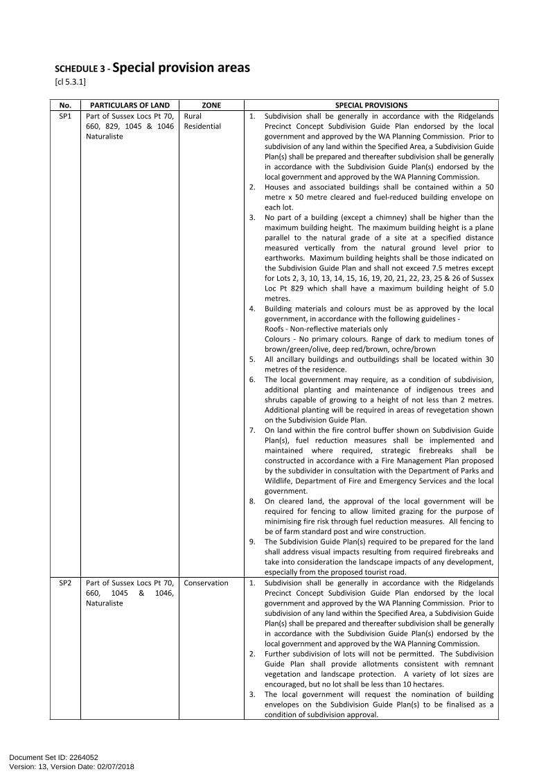
SCHEDULE 3 - Special provision areas[cl 5.3.1]
No. PARTICULARS OF LAND ZONE SPECIAL PROVISIONSSP1 Part of Sussex Locs Pt 70,
660, 829, 1045 & 1046 Naturaliste
Rural Residential
1. Subdivision shall be generally in accordance with the Ridgelands Precinct Concept Subdivision Guide Plan endorsed by the local government and approved by the WA Planning Commission. Prior to subdivision of any land within the Specified Area, a Subdivision Guide Plan(s) shall be prepared and thereafter subdivision shall be generally in accordance with the Subdivision Guide Plan(s) endorsed by the local government and approved by the WA Planning Commission.
2. Houses and associated buildings shall be contained within a 50 metre x 50 metre cleared and fuel-reduced building envelope on each lot.
3. No part of a building (except a chimney) shall be higher than the maximum building height. The maximum building height is a plane parallel to the natural grade of a site at a specified distance measured vertically from the natural ground level prior to earthworks. Maximum building heights shall be those indicated on the Subdivision Guide Plan and shall not exceed 7.5 metres except for Lots 2, 3, 10, 13, 14, 15, 16, 19, 20, 21, 22, 23, 25 & 26 of Sussex Loc Pt 829 which shall have a maximum building height of 5.0 metres.
4. Building materials and colours must be as approved by the local government, in accordance with the following guidelines -Roofs - Non-reflective materials onlyColours - No primary colours. Range of dark to medium tones of brown/green/olive, deep red/brown, ochre/brown
5. All ancillary buildings and outbuildings shall be located within 30 metres of the residence.
6. The local government may require, as a condition of subdivision, additional planting and maintenance of indigenous trees and shrubs capable of growing to a height of not less than 2 metres. Additional planting will be required in areas of revegetation shown on the Subdivision Guide Plan.
7. On land within the fire control buffer shown on Subdivision Guide Plan(s), fuel reduction measures shall be implemented and maintained where required, strategic firebreaks shall be constructed in accordance with a Fire Management Plan proposed by the subdivider in consultation with the Department of Parks and Wildlife, Department of Fire and Emergency Services and the local government.
8. On cleared land, the approval of the local government will be required for fencing to allow limited grazing for the purpose of minimising fire risk through fuel reduction measures. All fencing to be of farm standard post and wire construction.
9. The Subdivision Guide Plan(s) required to be prepared for the land shall address visual impacts resulting from required firebreaks and take into consideration the landscape impacts of any development, especially from the proposed tourist road.
SP2 Part of Sussex Locs Pt 70, 660, 1045 & 1046, Naturaliste
Conservation 1. Subdivision shall be generally in accordance with the Ridgelands Precinct Concept Subdivision Guide Plan endorsed by the local government and approved by the WA Planning Commission. Prior to subdivision of any land within the Specified Area, a Subdivision Guide Plan(s) shall be prepared and thereafter subdivision shall be generally in accordance with the Subdivision Guide Plan(s) endorsed by the local government and approved by the WA Planning Commission.
2. Further subdivision of lots will not be permitted. The Subdivision Guide Plan shall provide allotments consistent with remnant vegetation and landscape protection. A variety of lot sizes are encouraged, but no lot shall be less than 10 hectares.
3. The local government will request the nomination of building envelopes on the Subdivision Guide Plan(s) to be finalised as a condition of subdivision approval.
Version: 13, Version Date: 02/07/2018Document Set ID: 2264052
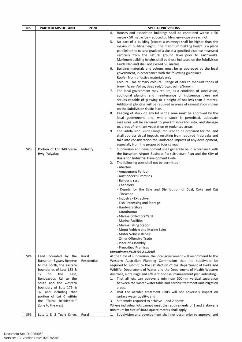
No. PARTICULARS OF LAND ZONE SPECIAL PROVISIONS4. Houses and associated buildings shall be contained within a 50
metre x 50 metre fuel-reduced building envelope on each lot.5. No part of a building (except a chimney) shall be higher than the
maximum building height. The maximum building height is a plane parallel to the natural grade of a site at a specified distance measured vertically from the natural ground level prior to earthworks. Maximum building heights shall be those indicated on the Subdivision Guide Plan and shall not exceed 5.0 metres.
6. Building materials and colours must be as approved by the local government, in accordance with the following guidelines -Roofs - Non-reflective materials onlyColours - No primary colours. Range of dark to medium tones of brown/green/olive, deep red/brown, ochre/brown.
7. The local government may require, as a condition of subdivision, additional planting and maintenance of indigenous trees and shrubs capable of growing to a height of not less than 2 metres. Additional planting will be required in areas of revegetation shown on the Subdivision Guide Plan.
8. Keeping of stock on any lot in the zone must be approved by the local government and, where stock is permitted, adequate measures will be required to prevent incursion into, and damage to, areas of remnant vegetation or replanted areas.
9. The Subdivision Guide Plan(s) required to be prepared for the land shall address visual impacts resulting from required firebreaks and take into consideration the landscape impacts of any development, especially from the proposed tourist road.
SP3 Portion of Lot 340 Vasse Hwy, Yalyalup
Industry 1. Subdivision and development shall generally be in accordance with the Busselton Airport Business Park Structure Plan and the City of Busselton Industrial Development Code.
2. The following uses shall not be permitted -- Abattoir- Amusement Parlour- Auctioneer’s Premises- Builder’s Yard- Chandlery- Depots for the Sale and Distribution of Coal, Coke and Cut
Firewood- Industry - Extractive- Fish Processing and Storage- Hardware Store- Laundromat- Marine Collectors Yard- Marine Facilities- Marine Filling Station- Motor Vehicle and Marine Sales- Motor Vehicle Repair- Other Offensive Trade- Place of Assembly- Prescribed Premises
(Amendment No.35 GG 2.2.2018)SP4 Land bounded by the
Busselton Bypass Reserve to the north, the eastern boundaries of Lots 183 & 12 to the east, Rendezvous Rd to the south and the western boundary of Lots 176 & 37 and including that portion of Lot 0 within the “Rural Residential” Zone to the west
Rural Residential
At the time of subdivision, the local government will recommend to the Western Australian Planning Commission that the subdivider be required to submit, to the satisfaction of the Department of Parks and Wildlife, Department of Water and the Department of Health Western Australia, a drainage and effluent disposal management plan indicating -1. That all lots can achieve a minimum 500mm vertical separation
between the winter water table and aerobic treatment unit irrigation areas;
2. That the aerobic treatment units will not adversely impact on surface water quality; and
3. Site works required to achieve 1 and 2 above.Where individual lots cannot meet the requirements of 1 and 2 above, a minimum lot size of 4000 square metres shall apply.
SP5 Lots 1 & 2 Tuart Drive, Rural 1. Subdivision and development shall not occur prior to approval and
Version: 13, Version Date: 02/07/2018Document Set ID: 2264052
No. PARTICULARS OF LAND ZONE SPECIAL PROVISIONSWonnerup Residential
Conservationadoption of a Structure Plan by the local government and the WA Planning Commission.
2. The local government will request, as a condition of subdivision, the preparation of a building envelope plan to the satisfaction of the Department of Parks and Wildlife and the City of Busselton to ensure no removal of Tuart trees and to minimise visual impacts of development from Tuart Drive.
3. At the time of making application for subdivision, the subdivider shall be required to submit an Effluent Disposal Management Plan to the satisfaction of the local government and the Department of Health WA.
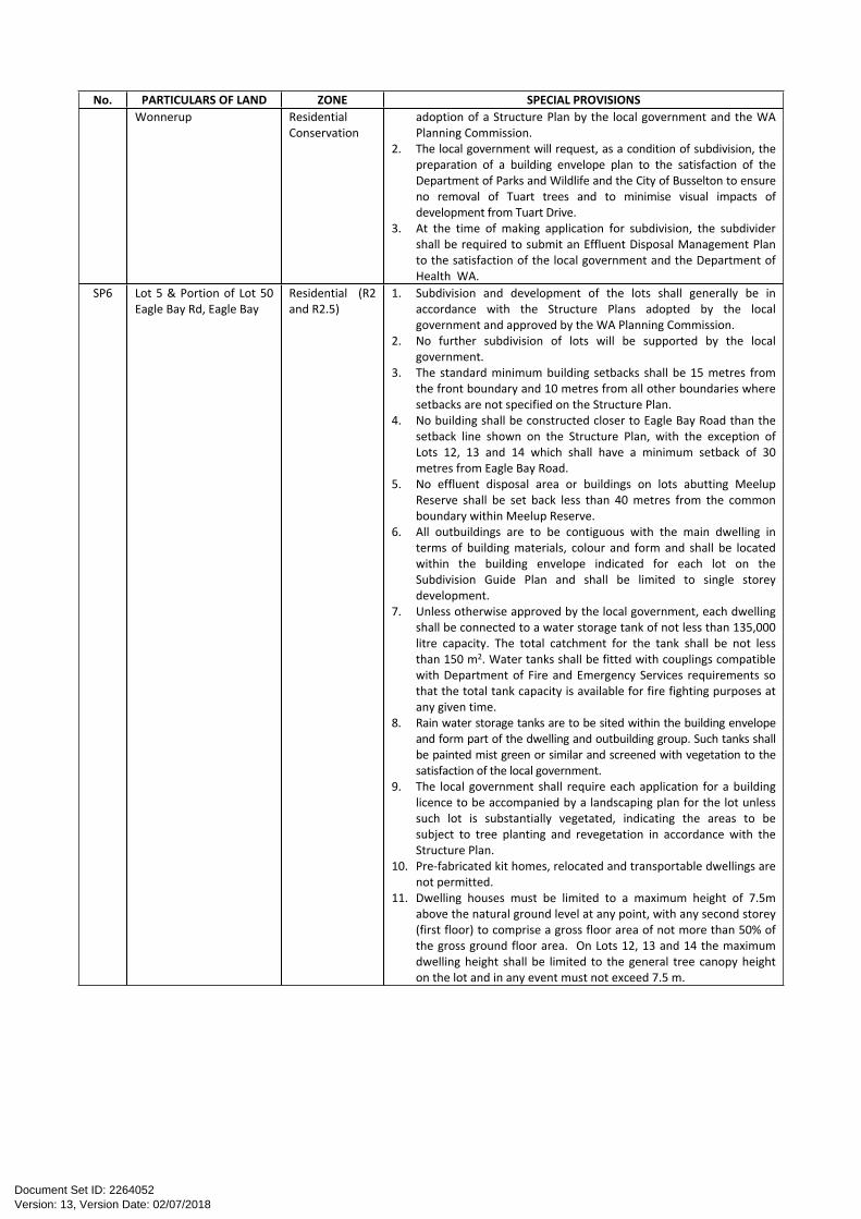
SP6 Lot 5 & Portion of Lot 50 Eagle Bay Rd, Eagle Bay
Residential (R2 and R2.5)
1. Subdivision and development of the lots shall generally be in accordance with the Structure Plans adopted by the local government and approved by the WA Planning Commission.
2. No further subdivision of lots will be supported by the local government.
3. The standard minimum building setbacks shall be 15 metres from the front boundary and 10 metres from all other boundaries where setbacks are not specified on the Structure Plan.
4. No building shall be constructed closer to Eagle Bay Road than the setback line shown on the Structure Plan, with the exception of Lots 12, 13 and 14 which shall have a minimum setback of 30 metres from Eagle Bay Road.
5. No effluent disposal area or buildings on lots abutting Meelup Reserve shall be set back less than 40 metres from the common boundary within Meelup Reserve.
6. All outbuildings are to be contiguous with the main dwelling in terms of building materials, colour and form and shall be located within the building envelope indicated for each lot on the Subdivision Guide Plan and shall be limited to single storey development.
7. Unless otherwise approved by the local government, each dwelling shall be connected to a water storage tank of not less than 135,000 litre capacity. The total catchment for the tank shall be not less than 150 m2. Water tanks shall be fitted with couplings compatible with Department of Fire and Emergency Services requirements so that the total tank capacity is available for fire fighting purposes at any given time.
8. Rain water storage tanks are to be sited within the building envelope and form part of the dwelling and outbuilding group. Such tanks shall be painted mist green or similar and screened with vegetation to the satisfaction of the local government.
9. The local government shall require each application for a building licence to be accompanied by a landscaping plan for the lot unless such lot is substantially vegetated, indicating the areas to be subject to tree planting and revegetation in accordance with the Structure Plan.
10. Pre-fabricated kit homes, relocated and transportable dwellings are not permitted.
11. Dwelling houses must be limited to a maximum height of 7.5m above the natural ground level at any point, with any second storey (first floor) to comprise a gross floor area of not more than 50% of the gross ground floor area. On Lots 12, 13 and 14 the maximum dwelling height shall be limited to the general tree canopy height on the lot and in any event must not exceed 7.5 m.
Version: 13, Version Date: 02/07/2018Document Set ID: 2264052
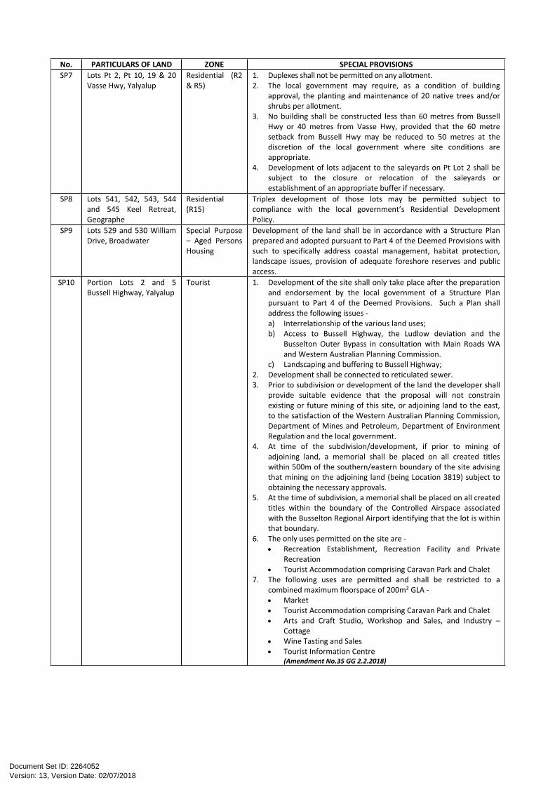
No. PARTICULARS OF LAND ZONE SPECIAL PROVISIONSSP7 Lots Pt 2, Pt 10, 19 & 20
Vasse Hwy, YalyalupResidential (R2 & R5)
1. Duplexes shall not be permitted on any allotment.2. The local government may require, as a condition of building
approval, the planting and maintenance of 20 native trees and/or shrubs per allotment.
3. No building shall be constructed less than 60 metres from Bussell Hwy or 40 metres from Vasse Hwy, provided that the 60 metre setback from Bussell Hwy may be reduced to 50 metres at the discretion of the local government where site conditions are appropriate.
4. Development of lots adjacent to the saleyards on Pt Lot 2 shall be subject to the closure or relocation of the saleyards or establishment of an appropriate buffer if necessary.
SP8 Lots 541, 542, 543, 544 and 545 Keel Retreat, Geographe
Residential (R15)
Triplex development of those lots may be permitted subject to compliance with the local government’s Residential Development Policy.
SP9 Lots 529 and 530 William Drive, Broadwater
Special Purpose – Aged Persons Housing
Development of the land shall be in accordance with a Structure Plan prepared and adopted pursuant to Part 4 of the Deemed Provisions with such to specifically address coastal management, habitat protection, landscape issues, provision of adequate foreshore reserves and public access.
SP10 Portion Lots 2 and 5 Bussell Highway, Yalyalup
Tourist 1. Development of the site shall only take place after the preparation and endorsement by the local government of a Structure Plan pursuant to Part 4 of the Deemed Provisions. Such a Plan shall address the following issues -a) Interrelationship of the various land uses;b) Access to Bussell Highway, the Ludlow deviation and the
Busselton Outer Bypass in consultation with Main Roads WA and Western Australian Planning Commission.
c) Landscaping and buffering to Bussell Highway;2. Development shall be connected to reticulated sewer.3. Prior to subdivision or development of the land the developer shall
provide suitable evidence that the proposal will not constrain existing or future mining of this site, or adjoining land to the east, to the satisfaction of the Western Australian Planning Commission, Department of Mines and Petroleum, Department of Environment Regulation and the local government.
4. At time of the subdivision/development, if prior to mining of adjoining land, a memorial shall be placed on all created titles within 500m of the southern/eastern boundary of the site advising that mining on the adjoining land (being Location 3819) subject to obtaining the necessary approvals.
5. At the time of subdivision, a memorial shall be placed on all created titles within the boundary of the Controlled Airspace associated with the Busselton Regional Airport identifying that the lot is within that boundary.
6. The only uses permitted on the site are - Recreation Establishment, Recreation Facility and Private
Recreation Tourist Accommodation comprising Caravan Park and Chalet
7. The following uses are permitted and shall be restricted to a combined maximum floorspace of 200m² GLA - Market Tourist Accommodation comprising Caravan Park and Chalet Arts and Craft Studio, Workshop and Sales, and Industry –
Cottage Wine Tasting and Sales Tourist Information Centre
(Amendment No.35 GG 2.2.2018)
Version: 13, Version Date: 02/07/2018Document Set ID: 2264052
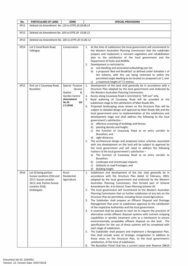
No. PARTICULARS OF LAND ZONE SPECIAL PROVISIONSSP11 Deleted via Amendment No. 125 to DTPS 20 20.08.13
SP12 Deleted via Amendment No. 105 to DTPS 20 10.06.12
SP13 Deleted via Amendment No. 105 to DTPS 20 15.06.12
SP14 Lot 2 Canal Rocks Road, Yallingup
Conservation 1. At the time of subdivision the local government will recommend to the Western Australian Planning Commission that the subdivider prepare and implement a remnant vegetation and rehabilitation plan to the satisfaction of the local government and the Department of Parks and Wildlife.
2. Development is restricted to:a) one dwelling and associated outbuildings per lot;b) a proposed ‘Bed and Breakfast’ as defined under Schedule 1 of
the Scheme, with this use being restricted to within the permitted single dwelling to be located on proposed Lot 2; and
c) a maximum height of 7.5 metres.SP15 Part Lot 1 Causeway Road,
BusseltonSpecial Purpose – Service Station & Garden Centre(Amendment No.35 GG 2.2.2018)
1. Development of the land shall generally be in accordance with a Structure Plan adopted by the local government and endorsed by the Western Australian Planning Commission.
2. Access along Causeway Road is restricted to “left out” only.3. Road widening of Causeway Road will be provided at the
subdivision stage to the satisfaction of Main Roads WA.4. Proposed landscaping areas shown on the Structure Plan will be
subject to detailed design and approval by Main Roads WA and the local government prior to implementation at the subdivision and development stage and shall address the following to the local government’s satisfaction –a) effective screening of buildings and fences;b) planting density and height;c) the function of Causeway Road as an entry corridor to
Busselton; andd) sight distances.
5. The architectural design and proposed colour schemes associated with any development on the land will be subject to approval by the local government and will need to address the following matters to the local government’s satisfaction –a) The function of Causeway Road as an entry corridor to
Busselton;b) Landscape and streetscape impacts;c) Setbacks to road frontages; andd) Building height.
SP16 Lot 20 being portion Sussex Locations 2316 and 2317; Sussex Location 1611; and, Portion Sussex Location 2318, Ambergate.
Rural ResidentialAgriculture
1. Subdivision and development of the lots shall generally be in accordance with the Structure Plan dated 12 February, 2003, adopted by the local government and endorsed by the Western Australian Planning Commission, that formed part of Scheme Amendment No. 4 to District Town Planning Scheme 20.
2. The local government will recommend to the Western Australian Planning Commission that no further subdivision of any lots on the Structure Plan be permitted, including those zoned Agriculture.
3. The Subdivider shall prepare an Effluent Disposal and Drainage Management Plan prior to subdivision approval to the satisfaction of the respective Authorities and the local government.
4. A covenant shall be placed on each lot to require the provision of alternative onsite effluent disposal systems with nutrient stripping capabilities or aerobic treatment units as a mechanism to ensure environmentally acceptable effluent disposal on the land. The specification for the use of these systems will be completed with each stage of subdivision.
5. The Subdivider shall prepare and implement a Revegetation Plan, that shall include areas of strategic revegetation in addition to those areas on the Structure Plan, to the local government's satisfaction, at the time of subdivision.
6. The Busselton Pistol Club has a current Lease over Reserve 28419
Version: 13, Version Date: 02/07/2018Document Set ID: 2264052
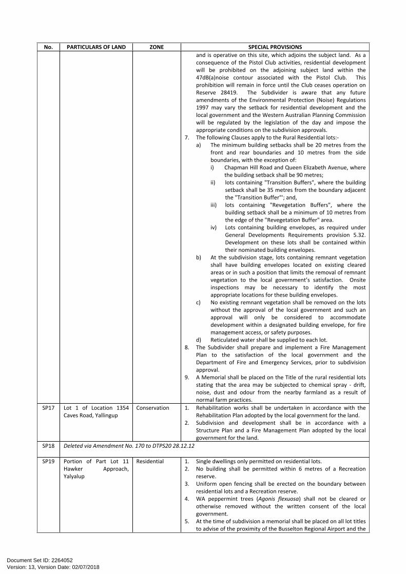
No. PARTICULARS OF LAND ZONE SPECIAL PROVISIONSand is operative on this site, which adjoins the subject land. As a consequence of the Pistol Club activities, residential development will be prohibited on the adjoining subject land within the 47dB(a)noise contour associated with the Pistol Club. This prohibition will remain in force until the Club ceases operation on Reserve 28419. The Subdivider is aware that any future amendments of the Environmental Protection (Noise) Regulations 1997 may vary the setback for residential development and the local government and the Western Australian Planning Commission will be regulated by the legislation of the day and impose the appropriate conditions on the subdivision approvals.
7. The following Clauses apply to the Rural Residential lots:-a) The minimum building setbacks shall be 20 metres from the
front and rear boundaries and 10 metres from the side boundaries, with the exception of:i) Chapman Hill Road and Queen Elizabeth Avenue, where
the building setback shall be 90 metres;ii) lots containing "Transition Buffers", where the building
setback shall be 35 metres from the boundary adjacent the "Transition Buffer"'; and,
iii) lots containing "Revegetation Buffers", where the building setback shall be a minimum of 10 metres from the edge of the "Revegetation Buffer" area.
iv) Lots containing building envelopes, as required under General Developments Requirements provision 5.32. Development on these lots shall be contained within their nominated building envelopes.
b) At the subdivision stage, lots containing remnant vegetation shall have building envelopes located on existing cleared areas or in such a position that limits the removal of remnant vegetation to the local government’s satisfaction. Onsite inspections may be necessary to identify the most appropriate locations for these building envelopes.
c) No existing remnant vegetation shall be removed on the lots without the approval of the local government and such an approval will only be considered to accommodate development within a designated building envelope, for fire management access, or safety purposes.
d) Reticulated water shall be supplied to each lot.8. The Subdivider shall prepare and implement a Fire Management
Plan to the satisfaction of the local government and the Department of Fire and Emergency Services, prior to subdivision approval.
9. A Memorial shall be placed on the Title of the rural residential lots stating that the area may be subjected to chemical spray - drift, noise, dust and odour from the nearby farmland as a result of normal farm practices.
SP17 Lot 1 of Location 1354 Caves Road, Yallingup
Conservation 1. Rehabilitation works shall be undertaken in accordance with the Rehabilitation Plan adopted by the local government for the land.
2. Subdivision and development shall be in accordance with a Structure Plan and a Fire Management Plan adopted by the local government for the land.
SP18 Deleted via Amendment No. 170 to DTPS20 28.12.12
SP19 Portion of Part Lot 11 Hawker Approach, Yalyalup
Residential 1. Single dwellings only permitted on residential lots.2. No building shall be permitted within 6 metres of a Recreation
reserve.3. Uniform open fencing shall be erected on the boundary between
residential lots and a Recreation reserve.4. WA peppermint trees (Agonis flexuosa) shall not be cleared or
otherwise removed without the written consent of the local government.
5. At the time of subdivision a memorial shall be placed on all lot titles to advise of the proximity of the Busselton Regional Airport and the
Version: 13, Version Date: 02/07/2018Document Set ID: 2264052
No. PARTICULARS OF LAND ZONE SPECIAL PROVISIONSpotential for noise impacts associated with the operation of the Airport.
6. The 40m wide public open space area/buffer along the western boundary of the school site and between Hawker Approach and Lot 313 shall be revegetated in consultation with the Department of Parks and Wildlife to the satisfaction of the City, prior to the issue of clearance of subdivision.
7. The developer to undertake an eradication plan for arum lilies and noxious weeds to the satisfaction of the local government, prior to the issue of clearance of subdivision.
SP20 Deleted via Amendment No. 1 to LPS 21 04.08.17SP21 Lot 5 of Sussex Location
122 Coley Road, YallingupConservation 1. Subdivision and development shall be generally in accordance with
a Structure Plan and the Fire Management Plan as adopted by the local government, both forming part of Amendment No. 65 to District Town Planning Scheme 20.
2. Rehabilitation works shall be undertaken prior to issue of clearances for subdivision in accordance with the Rehabilitation / Revegetation Plan adopted by the local government for the land.
3. A Weed Management Plan is to be prepared and implemented for the subject land and is to be maintained in perpetuity by the owner and subsequent owners of the property(ies).
SP22 Lot 401 Spindrift Cove, Dunsborough
Residential (R25)
1. Development and subdivision of Lot 401 shall generally be in accordance with the approved Structure PlanSTRUCTURE PLAN as contained within the Amendment documents (Amendment No. 78 to the Shire of Busselton District Town Planning Scheme No. 20).
2. Development and subdivision of Lot 401 shall be restricted to a maximum of 12 dwellings/lots
3. Notwithstanding the applicable R25 density code, the R-Codes requirements for the R30 code may be applied in respect to minimum lot sizes and setbacks.
SP23 Lots 2, 6, 31, 32, 202, 501 and 9003 Vasse and Bussell Highways, Yalyalup
Special Purpose (Yalyalup Development Area) andSpecial Purpose (Yalyalup Deferred Development Area)
1. Development (including subdivision) of the land shall be generally in accordance with the Structure Plan and the Detailed Area Plan for the land adopted by the local government and endorsed by the Western Australian Planning Commission pursuant to the Scheme.
2. Notwithstanding the provisions of Part 3 of the Scheme, the Structure Plan shall include the following details:a) the area to which the Structure Plan applies;b) key opportunities and constraints of the Development Area
including, landform, topography, hydrology, landscape, vegetation, soils, conservation and heritage values, ownership, land use, roads and public transport and services;
c) the planning context for the Development Area including the regional and neighbourhood structure, relevant strategies, Scheme provisions and policies and where appropriate, indicating how the proposed Structure Plan is to be integrated into the surrounding area;
d) proposed major land uses, in particular, residential areas, public open space and arrangements between different owners if required, school sites, civic and community uses, commercial uses (including the location and hierarchy of commercial centres), mixed use, service industrial and mixed business uses;
e) estimates of future lots (yield), indicative lot layout, dwellings, the average lot area and density (codings), population, employment and commercial floor space;
f) provision for major infrastructure e.g. main drainage, sewerage, water supply and other key infrastructure services, including the future servicing of the industrial land identified on the Busselton Airport Structure Plan;
g) the proposed road network and hierarchy, public transport services, and bicycle and pedestrian networks;
h) buffers or other similar treatment at the interface between development cells and main / arterial roads / local distributor roads / significant local roads or adjoining land;
Version: 13, Version Date: 02/07/2018Document Set ID: 2264052
No. PARTICULARS OF LAND ZONE SPECIAL PROVISIONSi) the boundaries of all development precincts which are to be
subject of Detailed Area Plans; j) an ethnographic and archaeological survey is undertaken and
the findings are reported to the local government and the Department of Indigenous Affairs. Any changes to the subdivision design resulting from the findings of the survey(s) shall be considered in the preparation of the Structure Plan;
k) mosquito management strategy (which may be integrated with the drainage management strategy/plan) and implementation strategy is approved by the local government;
l) a traffic management plan is approved by the local government;
m) a drainage management strategy/plan is approved by the local government;
n) the landscaping strategy; and o) such other information as may be required by the local
government.3. The provisions of the endorsed Structure Plan apply to the land as if
its provisions were incorporated into the Scheme and are binding and enforceable in the same manner as those provisions included in the Scheme.
4. All provisions (such as land use and development controls or approval procedures) applicable to a zone, reserve or R-Code pursuant to the Scheme shall apply to the corresponding land use designations pursuant to the endorsed Structure Plan.
5. a) A Detailed Area Plan (DAP) may be required by the local government and where required shall be prepared and submitted for a lot or lot(s):i) to enhance, elaborate or expand on the details or
provisions contained in a proposed Structure Plan or a Structure Plan;
ii) in place of a development approval required to comply with Part 2 of the Residential Design Codes; or
iii) for any other planning purpose.b) Upon receiving a Detailed Area Plan the local government is to
either:i) Determine that the Detailed Area Plan is to be advertised
for a minimum period of 21 days; orii) Determine that the Detailed Area Plan is to be considered
without advertising; oriii) Determine that the Detailed Area Plan is not to be
advertised or considered until further details have been provided or modifications undertaken; or
iv) Determine that the Detailed Area Plan is not satisfactory for advertising or immediate consideration and refuse it, with the reasons for this decision to be provided to the proponent.
c) If within 90 days of receiving a Detailed Area Plan under clause 5(a) of this Schedule, or such longer period as may be agreed in writing between the person and the local government, the local government has not made one of the determinations referred to in clause 5(b) of this Schedule, the local government is deemed to have refused to approve the Detailed Area Plan.
6. A Detailed Area Plan is to be used as the basis for; a) making recommendations to the Western Australian Planning
Commission on subdivision applications; andb) determining applications for development approval with
respect to the land subject to the Detailed Area Plan.7. A Detailed Area Plan may include details as to:
a) building envelopes;b) distribution of land uses within a lot;c) private open space;d) services;
Version: 13, Version Date: 02/07/2018Document Set ID: 2264052
No. PARTICULARS OF LAND ZONE SPECIAL PROVISIONSe) vehicular access, parking, loading and unloading areas, storage
yards and rubbish collection closures;f) the location, orientation and design of buildings and the space
between buildings;g) advertising signs, lighting and fencing;h) landscaping, finished site levels and drainage;i) protection of sites of heritage, conservation or environmental
significance;j) special development controls and guidelines;k) noise buffering;l) ancillary dwellings, and/or studio dwellings, home business or
home workspace;m) encroachments (reciprocal right of-way, party walls)n) variations from the Residential Design Codes and other
provisions for land use and development control;o) landscaping strategies/plans that are considered along with a
Detailed Area Plan shall include:i) restoration of remnant vegetation in public open space
areas including the replacement of endemic understorey plant species where considered necessary and management of weeds; and
ii) the retention of paddock trees where practicable; andiii) the provision of habitat for wetland bird species and
rehabilitation of wetland areas, where appropriate.8. Notification of prospective purchasers by way of memorial on the
title of proposed lots is to be undertaken to warn of the potential threat of viral infection from mosquitoes.
9. At the subdivision stage, notification of landowners and prospective purchasers by way of a memorial on the title of the proposed lots is to be undertaken, to inform landowners of possible airport noise with respect to the nearby Busselton Airport operations. A memorial is to be inserted on the title of lots in close proximity to Bussell Highway, Vasse Highway and the proposed Outer Bypass to advise that the amenity of the lot may be affected by traffic noise to the satisfaction of the City of Busselton and Main Roads.
10. Prior to subdivision or development the proponent is to prepare a developer contribution and staging plan to the satisfaction of the City to ensure the proponents appropriate and timely contribution toward service infrastructure and community facilities on a progressive and staged basis. An appeal right will exist in respect to determination of the plan pursuant to Part 9 of the Deemed Provisions.
11. The local government has prepared a draft Noise Management Plan for Busselton Regional Airport, which requires approval by the Environmental Protection Authority. The local government may recommend conditions on the subdivision and development of land requiring noise amelioration measures consistent with the draft Noise Management Plan and subsequently with the Noise Management Plan as finally approved by the Environmental Protection Authority.
SP24 Lot 123 Geographe Bay Road and portion of Part Sussex Location 170 Peppermint Drive, Dunsborough
Residential R15 and R30 as per the Scheme map
1. Restrictive covenants apply to the title of lots created from the land and identify a vegetation protection area which serves to prevent the removal of WA peppermint (Agonis flexuosa). The purpose of the restrictive covenants is to preserve habitat for Western Ringtail Possum.
2. No vegetation is permitted to be removed from within the area specified in the restrictive covenant as a vegetation protection area unless such removal is first determined by the local government as being necessary for fire protection or safety purposes.
SP25 Lots 1 and 2 of Sussex Location 364 Smiths Beach Road, Yallingup
Tourist 1. Subdivision and development shall be in accordance with the Structure Plan adopted by the local government and endorsed by the Western Australian Planning Commission pursuant to the process and requirements set out under Part 4 of the Deemed Provisions.
Version: 13, Version Date: 02/07/2018Document Set ID: 2264052
No. PARTICULARS OF LAND ZONE SPECIAL PROVISIONS2. No further development or subdivision shall be permitted (except
survey strata or strata subdivision of tourist accommodation units) apart from that which is shown on the adopted and endorsed Structure Plan.
3. A Structure Plan (including modification) will only be considered by the local government and the Western Australian Planning Commission where a Structure Plan is submitted over the whole of Lots 1 and 2 of Sussex Location 364 Smiths Beach Road, Yallingup and is consistent with the orderly and proper planning for the land and locality.
SP26 Pt Lot 17 and Lot 16 West Street, West Busselton
Restricted Business
1. Development shall be in accordance with a Land Use Concept Plan adopted by the local government.
2. Development of the land shall make provision for public access and dual use path connections between Prince Regent Drive and Bussell Hwy and West Street in the first stage of development, at the full cost of the developer and to the satisfaction of the local government.
3. Development shall make provision for a foreshore and drainage reserve incorporating appropriate wetland buffers and providing for long term public access on site in the first stage of development, to the satisfaction of the City. The reserve is to be surrendered to the Crown free of cost for vesting in the local government.
4. A Stormwater and Drainage Management Plan shall be prepared by the developer prior to any subdivision or development that addresses, inter alia, the management of stormwater on site, the provision of nutrient and pollution stripping mechanisms, and avoids adverse impacts on the adjacent wetlands, including during construction, to the satisfaction of the Department of Parks and Wildlife and the local government.
5. Development shall address the interface with adjacent Residential zoned land to ensure an appropriate level of amenity and privacy by achieving low impact development outcomes adjacent to the Residential zoned land to the satisfaction of the local government.
6. Dust and Noise Management Plans are to be prepared and implemented to the satisfaction of the City in order to maintain the amenity of adjoining residential areas.
SP27 Portion of Lot 9101 Bussell Highway, Abbey
Residential 1. Subdivision and development shall be generally in accordance with the Structure Plan adopted for the land.
2. No further subdivision of lots shall be permitted.3. Grouped dwellings, including duplexes, shall not be permitted on any
lot.SP28 Deleted via Amendment No. 170 to DTPS 20 28.12.12SP29 Lots 501 – 510 Milkman
Avenue, BroadwaterResidential (R40) All dwellings / grouped dwellings are to have direct frontage to the
road, with battleaxe development and / or battleaxe subdivision (including survey strata and strata subdivision) prohibited.
SP30 Lots 4012 Nuttman Road, Chapman Hill
Conservation Subdivision and Development shall be in accordance with the Structure Plan and Fire Management Plan contained within Amendment No. 113 to the Shire of Busselton District Town Planning Scheme No. 20.
SP31 Lot 6, Commonage Road, Quindalup
Industrial 1. The intent of the Dunsborough Industrial Park is to establish an innovative, industrial estate which caters for a wide range of service and industrial activities together with other urban-based, service commercial and industrial activities which are required to cater for the existing and future industrial and service needs of the Dunsborough and surrounding districts.
2. a) Prior to approving the subdivision or development of land within the Dunsborough Industrial Park, the local government shall require the preparation and adoption, under the provisions of Part 4 of the Deemed Provisions, of a Structure Plan for the land;
b) The Structure Plan must obtain the endorsement of the Western Australian Planning Commission prior to coming into effect.
c) Where the local government rejects the Structure Plan, or attaches conditions or requires modification which the applicant considers unreasonable, the applicant shall have the right of review pursuant to Part 14 of the Act.
Version: 13, Version Date: 02/07/2018Document Set ID: 2264052
No. PARTICULARS OF LAND ZONE SPECIAL PROVISIONSd) Prior to exercising any right of review pursuant to Part 14 of the
Act, against a decision of the local government the proponent shall submit the Structure Plan and the local government’s resolution to the Western Australian Planning Commission and request the Western Australian Planning Commission to make a determination.
e) Where the Commission or the local government attaches conditions or requires modification which the applicant considers unreasonable, the applicant shall have the right of review pursuant to Part 14 of the Act.
3. The local government shall require the Structure Plan to have regard for adjacent lands and such Plan shall show how the land is to be subdivided and developed, including –a) The proposed size and distribution of lots;b) The proposed allocation of land uses, where appropriate;c) The proposed provision and treatment of buffer areas required
by the local government to protect the amenity of surrounding land uses;
d) The proposed provision and treatment of buffer areas to the sewerage treatment plant situated to the north of the land, in the event that the plant is not relocated;
e) The proposed provision and treatment of buffer areas required to protect important watercourses traversing the site;
f) The provision to be made for the control and management of stormwaters and the management of nutrients;
g) The proposed road system, including road reserve and carriageway widths;
h) The proposed provision of community and public utilities and services;
i) Any special provisions applying to the subdivision and development of the land where not otherwise provided for by the Scheme; and
j) Such other information as, in the circumstances of the case, the local government considers appropriate.
4. a) All necessary buffers to all adjoining lots required as a result of industries located on the Estate shall be provided on Lot 6 of Sussex Location 362 & 802;
b) The Plan shall make provision for buffer areas to the eastern and southern boundaries of the site so as to maintain the amenity of adjoining residences.
SP32 Portion of Lot 21 of Sussex Location 171 Caves Road, Quindalup
Special Purpose 1. Subdivision and development shall generally be in accordance with the Structure Plan endorsed by the City and the Western Australian Planning Commission.
2. A maximum of 5 lots (excluding the proposed conservation reserve) may be created from the subdivision of the land. No further subdivision will be permitted.
3. Single dwellings only permitted on residential lots. SP33 Lots 11, 35 and 41 Bussell
Highway, BusseltonResidential R40/R60
1. Prior to submission of an application for development approval, a single Structure Plan for the whole site shall be prepared and adopted consistent with Part 4 of the Deemed Provisions, except that it will not require endorsement by the Western Australian Planning Commission.
2. The Structure Plan shall ensure that for all residential development above R40:a) not less than 60% of units are single bedroom;b) the average and minimum site area may be varied by a
maximum of 5% less than that minimum area specified in table 1 of the Residential Design Codes of WA in addition to the density bonus applicable to single bedroom dwellings;
c) development is orientated towards and provides for public surveillance of Bussell Highway; and
d) development demonstrates outstanding environmental and sustainability features.
SP34 Lots 65, 77, 4516, & 246 Residential R40 1. The land shall be developed at a minimum density equivalent to R30.
Version: 13, Version Date: 02/07/2018Document Set ID: 2264052
No. PARTICULARS OF LAND ZONE SPECIAL PROVISIONSPettit Crescent, West Busselton
2. At the time of development or subdivision, whichever occurs first, an east - west Dual Use Path link being developed for the whole length of the frontage of Lots 65 and 77 in the adjoining reserve to the south, with connectivity to Pettit Crescent and Fairway Drive to the satisfaction of the City of Busselton and the Department of Parks and Wildlife.
3. At the time of development or subdivision, whichever occurs first, a Revegetation Plan being prepared and implemented, to the satisfaction of the City of Busselton and the Department of Parks and Wildlife, for the balance of the Reserve (Lots 427 and 391).
4. Development shall not detract from the visual amenity of the area having regard to the cumulative visual effect of the development adjacent to a Landscape Value Area. Building design, where applicable, is to address and allow for visual surveillance of the Reserve to the south.
5. Fencing associated with residential development adjoining the Reserve is to be of a uniform, open style design for that portion above 1.2m and is to be provided by the developer at the time of development or subdivision, whichever occurs first.
6. A Stormwater and Drainage Management Plan shall be prepared for the site and implemented to the satisfaction of the City of Busselton and Department of Water at the subdivision or application for development approval stage, whichever occurs first.
SP35 Lot 6 (9) Brown Street, Busselton
Business Notwithstanding the provisions contained within clause 4.2 and clause 5.20 of the Scheme, the City may consider the development of the entire site for residential purposes equivalent to an R80 density or alternatively a mixed-use development to an equivalent density.
SP36 Lots 9009, 204, 205, 1602 and portion of Lot 203 Neville Hyder Drive, Yalyalup and Lots 11, 300, 17 and 9501 Vasse Highway, Yalyalup
Special Purposes (Yalyalup Industrial Development Area)
1. Subdivision and development shall generally be in accordance with the Structure Plan for the land adopted by the local government and endorsed by the Western Australian Planning Commission pursuant to Part 4 of the Deemed Provisions.
2. Notwithstanding the provisions of Part 4 of the Deemed Provisions, the Structure Plan shall include the following details:a) The area to which the Structure Plan applies;b) Key opportunities and constraints of the Development Area
including, landform, topography, landscape, vegetation, soils, land capability, conservation and environmental values including bushland, wetlands, damp lands, streams and water courses and any environmental policy areas; hydrological conditions including approximate depth to water table; and sites and features of heritage value;
c) The planning context for the development area including transport routes and existing and future land use;
d) Proposed major land uses in particular, industrial areas and approximate lot sizes, commercial uses and other activities;
e) Urban water management including water quality;f) Important site features to be retained;g) Details of any staging of subdivision and development;h) Estimates of future lots, employment and commercial floor
space;i) Provision of major infrastructure e.g. main drainage, sewerage,
water supply and other key infrastructure services;j) Demonstration of adequate visual and / or noise buffers or other
similar treatment, where appropriate, at the interface between development cells and main / arterial roads or adjoining land;
k) The boundaries of specific industry development precincts;l) Any other information as may be required by the local
government;m) Demonstration that access to the land from Vasse Highway has
been provided to the specifications and satisfaction of Main Roads WA and City of Busselton;
n) Arrangements are made with respect to infrastructure within the locality and the district and timely access is provided to all lots; and
Version: 13, Version Date: 02/07/2018Document Set ID: 2264052
No. PARTICULARS OF LAND ZONE SPECIAL PROVISIONSo) Arrangements are made for the appropriate ceding of the
Busselton Outer Transit Corridor.3. The provisions of the endorsed Structure Plan apply to the land as if
they were incorporated into the Scheme and are binding and enforceable in the same manner as those provisions included in the Scheme;
4. All provisions (such as land use and development controls or approval procedures) applicable to a zone or reserve pursuant to the Scheme shall apply to the corresponding land use designations pursuant to the endorsed Structure Plan;
5. If there is any conflict between the provisions of the Scheme and the Structure Plan, the provisions of the Structure Plan shall prevail;
6. At the subdivision stage notification to prospective purchasers by way of a memorial on title of proposed lots is to be undertaken to warn of the potential threat of viral infection from mosquitoes;
7. Prior to lodgement of a subdivision application, a drainage management framework shall be prepared for Lots 9009, 203, 204 and 205 that outlines a coordinated approach to, and demonstrates management measures for, stormwater management, to the satisfaction of the City of Busselton and Department of Water.
8. Any application for subdivision approval to the WA Planning Commission for the subject land shall be accompanied by an Urban Water Management Plan approved by the City of Busselton and Department of Water. The UWMP is to provide particular consideration to the usage and impact of drainage outcomes on the south western bushland and storage area within the Busselton Outer Transit Corridor Buffer areas, as follows:a) Invert (base) levels of basins;b) AAMGL of groundwater under basin to show adequate
separation;c) Any clearing necessary to construct the basin with appropriate
approvals;d) Any flooding regimes of natural bush within basin areas including
appropriate approvals; ande) Any infrastructure necessary to contain flows within the bund
area so that it doesn't flood surrounding bushland.9. As a condition of subdivision approval, the proponent/landowner is
to:a) Prepare and implement a Western Ringtail Possum Management
Plan to the satisfaction of the Department of Parks and Wildlife prior to commencement of works.
b) Undertake investigations into acid sulphate soils and, if required as a result of the outcomes and recommendations of this investigation, include management proposals in the construction management programme to the satisfaction of the Department of Environment Regulation and City of Busselton prior to commencement of works.
c) Prepare and implement a revegetation and rehabilitation programme to the satisfaction of the Department of Parks and Wildlife and the City of Busselton with regard to areas of remnant vegetation to be retained and landscape buffers to adjoining travel routes or corridors prior to commencement of works.
d) Prepare and implement a Bushland / Reserve Management Plan to the satisfaction of the Department of Parks and Wildlife and City of Busselton for areas of remnant vegetation to be retained prior to commencement of works.
e) Prepare and implement a Western Grey Kangaroo Management and Relocation Strategy to the satisfaction of the Department of Parks and Wildlife prior to commencement of works.
10. A Detailed Area Plan is to be prepared by the proponent and adopted by the local government for the areas identified on the endorsed Structure Plan prior to lodgement of a subdivision application within this precinct. The Detailed Area Plan is to contain the following details
Version: 13, Version Date: 02/07/2018Document Set ID: 2264052
No. PARTICULARS OF LAND ZONE SPECIAL PROVISIONSto satisfy the planning requirements of the precincts as appropriate:a) a schedule of proposed land uses and corresponding indicative
floor space;b) the proposed internal and external road network;c) a traffic management assessment undertaken by a suitably
qualified traffic engineer;d) strategic location of consolidated access points;e) details of shared parking, loading and unloading areas, storage
yards and rubbish collection enclosures;f) indicative lot layout;g) the lot yield;h) the average lot area and density;i) distribution of land uses within a lot;j) vehicular access, parking, loading and unloading areas, storage
yards and rubbish collection enclosures;k) the location, orientation and design of buildings and the space
between buildings;l) advertising signs, lighting and fencing;m) communal open space provision and arrangements between
different landowners, if required;n) drainage areas;o) landscaping;p) special development controls and guidelines; andq) any other information considered relevant by the local
government and required to satisfy the principles, objectives and provisions of the Structure Plan.
11. If after advertising or immediate consideration, the local government determines the Detailed Area Plan to be generally consistent with the endorsed Structure Plan, the Scheme and the orderly and proper planning of the locality, the local government may adopt the Plan with or without modification.
12. The right of appeal pursuant to Part 9 of the Deemed Provisions shall apply to any decision made by the local government in respect to a Detailed Area Plan.
SP37 Deleted via Amendment No. 162 to DTPS 20 03.10.13SP38 Lot 22 Caves Road,
WilyabrupViticulture/TourismConservation
1. Subdivision and development is to be generally in accordance with a Structure Plan and a Fire Management Plan for the site as adopted by the local government and approved by the Western Australian Planning Commission (WAPC).
2. No existing remnant vegetation shall be removed from the 'Conservation' zoned lot, other than for compliance with an approved Fire Management Plan, vehicle access to buildings associated with approved development, clearing for approved development within a building envelope and provision of service infrastructure.
3. Remnant vegetation within the ‘Conservation’ zoned lot shall be the subject of a conservation covenant to be implemented at the time of subdivision, to the satisfaction of the relevant administering authority.
4. As a condition of subdivision, the subdivider is to prepare and implement to the satisfaction of the covenanting authority:a) A regeneration, rehabilitation and revegetation plan which
addresses Western Grey Kangaroo management/exclusion; andb) A weed and pest management plan for the ‘Conservation’ zoned
lot.SP39 Lots 2, 301, 126, 804, 1, 4,
2363, 3, 51, 52, 11, 33, 50, 15, 35, 9, 13, 7, 161, 163, 2364 and 2365 and portion of Lots 22, 57, 2191, 2192 and 2193 Busselton Bypass, Chapman Hill Road and Queen Elizabeth Avenue, Busselton
Special Purpose(Ambergate NorthDevelopment Area),Agriculture and Development Investigation Area
General1. Development (including subdivision) of the land shall be generally in
accordance with a Structure Plan and any applicable Detailed Area Plan (DAP) for the land adopted by the local government and endorsed by the Western Australian Planning Commission (WAPC) pursuant to the Scheme.
Structure Plan Content Requirements2. The Structure Plan will be required to address the specific notations
and requirements, planning policy statements and requirements for structure planning as outlined in the endorsed 'Ambergate North
Version: 13, Version Date: 02/07/2018Document Set ID: 2264052
No. PARTICULARS OF LAND ZONE SPECIAL PROVISIONSDistrict Structure Plan'.
3. Notwithstanding the provisions of Part 4 of the Deemed Provisions, the Structure Plan shall include the following details:a) the area to which the Structure Plan applies;b) key opportunities and constraints of the Structure Plan area
including landform, topography, landscape, vegetation, soils, land capability, conservation and environmental values (including bushland, wetlands, damp lands, streams and water courses and any environmental policy areas), hydrological conditions (including approximate depth to water table) and sites and features of heritage value;
c) the planning context for the Structure Plan area and the surrounding locality including transport routes (including bypass, arterial routes and neighbourhood collector alignments, public transport routes, strategic footpath/cycle routes and bus stops), and existing and future land use;
d) proposed major land uses, in particular, residential areas and densities, public open space, school sites, civic and community uses, commercial uses (including the location and hierarchy of commercial centres) and mixed use activities;
e) a 'Pedestrian & Cyclist Access Plan' with a strong emphasis on reducing motor vehicle reliance;
f) urban water management, including water quality;g) promoting conservation of ecological systems and the
biodiversity they support, including ecosystems, habitats, species and genetic diversity;
h) significant natural corridors and important site features to be retained;
i) details of any staging of subdivision and development;j) estimates of future lots, dwellings, population, employment and
commercial floor space;k) provision for major infrastructure e.g. roads, main drainage,
sewerage, water supply and other key infrastructure services;l) buffers or other similar treatments at the interface between
development cells and main/arterial roads or adjoining land;m) the boundaries of specific development precincts which are to
be subject to Detailed Area Plans; andn) any other information as may be required by the City.
Structure Plan Operation4. The conditions of the endorsed Structure Plan apply to the land as if
they were incorporated into the Scheme and are binding and enforceable in the same manner as those provisions included in the Scheme.
5. For land within the 'Special Purpose (Ambergate North Development Area)' zone, all provisions (such as land use and development controls or approval procedures) applicable to a zone, reserve or R-Code pursuant to the Scheme shall apply to the corresponding land use designations pursuant to the endorsed Structure Plan.
Structure Plan Review6. Notwithstanding that reviews of aspects of the Structure Plan may
occur from time to time, within ten years of its endorsement by the local government and the WAPC, any Structure Plan relating to the land shall be subject of an overall, high-level review in the context of the planning framework applicable at the time. The review process shall be the same as the process for the adoption of a new Structure Plan, with the scope of the review being sufficient to ensure that the Structure Plan meets contemporary planning requirements to the satisfaction of the City and WAPC. If an overall review has not been completed within the specified timeframe, the local government and/or the WAPC may refuse applications for development approval and/or subdivision approval until such time as a review has been undertaken.
DAP Requirements7. A Detailed Area Plan (DAP) is to be prepared and adopted by the local
Version: 13, Version Date: 02/07/2018Document Set ID: 2264052
No. PARTICULARS OF LAND ZONE SPECIAL PROVISIONSgovernment and WAPC for the Village Centre and Local Centre precincts as identified on the endorsed Structure Plan prior to subdivision and/or development within those precincts. The DAP is to contain the following details:a) the proposed internal and external road network;b) the proposed bicycle and pedestrian network - dual use paths
and footpaths;c) distribution of land uses within a lot;d) essential infrastructure services;e) vehicular access, parking, loading and unloading areas, storage
yards and rubbish collection enclosures;f) the provision of appropriate interface treatments between
proposed development and local distributor roads or significant local roads;
g) the location, orientation and design of buildings and the space between buildings;
h) advertising signs, lighting and fencing;i) protection of areas and sites of heritage, architectural, aesthetic,
scientific, cultural, conservation or environmental significance;j) indicative lot layout;k) the lot yield;l) the average lot area and density;m) public open space provision and arrangements between
different landowners, if required;n) drainage areas:o) density codings;p) special development controls and guidelines; q) a landscape concept plan, which includes the use of local
endemic species that occur within the relevant vegetation complexes and soil types across the Structure Plan area; and
r) any other information considered relevant by the City of Busselton and required to satisfy the principles, objectives and provisions of the Structure Plan.
8. The DAP for the Village Centre shall include, in addition to that outlined in the above clause, the following requirements to the satisfaction of the City of Busselton and WAPC:a) initial retail facilities to be located at the entrance (northern end)
of the Village Centre;b) identification of a Discount Department Store site and proposed
interim land use including the method of land use transition. and a shop retail floorspace threshold that is not to be exceeded until such time as the interim use has been developed;
c) provision for bulky goods retailing in addition to shop retail development; and
d) inclusion of an education/technology precinct, possibly in proximity to the district open space.
DAP Operation9. Upon receiving a DAP the local government is to either:
a) Determine that the DAP is to be advertised for a minimum period of 21 days; or
b) Determine that the DAP is to be considered without advertising; or
c) Determine that the DAP is not to be advertised or considered until further details have been provided or modifications undertaken; or
d) Determine that the DAP is not satisfactory for advertising or immediate consideration and refuse it, with the reasons for this decision to be provided to the proponent.
10. If after advertising or immediate consideration, the local government determines the DAP to be generally consistent with the endorsed Structure Plan, the Scheme and the orderly and proper planning of the locality, the local government may adopt the DAP with or without modification and forward the DAP to the WAPC for its endorsement. Any substantial changes to the DAP may require a revised Structure
Version: 13, Version Date: 02/07/2018Document Set ID: 2264052
No. PARTICULARS OF LAND ZONE SPECIAL PROVISIONSPlan to be adopted by the City of Busselton and the WAPC.
11. The right of appeal in relation to a Structure Plan pursuant to Part 9 of the Deemed Provisions shall apply to any decision made by the City of Busselton and WAPC in respect to a DAP; and
Retail Floorspace Controls12. Retail floor space within the Village Centre shall be limited to
14,000m2 NLA. 13. A Department Store is not permitted in the village centre or Structure
Plan area.14. Retail floor space within the Village Centre shall not exceed 9000m2
NLA or accommodate a Discount Department Store until the following has occurred:a) The development of two Discount Department Stores in the
Busselton town centre;b) The development of a minimum 50,000m2 of shop retail NLA in
the Busselton town centre; andc) Confirmation of compliance with a City level hierarchy as
established in an adopted commercial strategy for the City.15. For the purposes of these special provisions, 'Discount Department
Store' shall be defined as "a single large shop retail store organized into departments offering a variety of merchandise; commonly part of a retail chain with NLA of greater than 5,000m2, but does not include a Department Store".
16. Retail floor space within the Local Centre shall not exceed 500m2 NLA until the Village Centre has a developed retail floor space of a minimum 5,000m2 NLA.
Developer Contributions and Staging Requirements17. Pursuant to the requirements of the Ambergate North District
Structure Plan, prior to the approval of development (including subdivision) proposed by an endorsed Structure Plan, a Developer Contributions and Staging Plan (DCSP) shall be prepared to the satisfaction of the City of Busselton and WAPC. The DCSP is to be prepared in consultation with all landowners in the Structure Plan area and is to comprehensively address the staging of development and the equitable provision of community facilities, public open space and civil infrastructure. An appeal right exists in respect to the determination of the DCSP pursuant to Part 9 of the Deemed Provisions.
18. Contributions shall be made by all landowners within the Structure Plan area in accordance with the requirements of the endorsed DCSP.
Development Requirements19. Any application for subdivision shall be accompanied by an Urban
Water Management Plan (UWMP) applicable to the application area that has been adopted/endorsed by the City of Busselton, Department of Water and Department of Parks and Wildlife. The UWMP is to provide particular consideration to the usage and impact of drainage outcomes on the northern bushland and wetland area.
20. All development and subdivision shall meet the requirements and objectives of an approved Water Quality Improvement Plan for the Vasse Wonnerup Wetlands and Geographe Bay to the satisfaction of the City of Busselton and Department of Water.
21. Prior to development (including subdivision), a 'Sustainability Outcomes and Implementation Plan' is to be prepared, which details the targets and methods of delivery in respect to 'sustainability outcomes' inclusive of:a) on-site power generation;b) efficient use of power and water;c) on-site water capture and re-use;d) re-use of grey water; ande) correct housing orientation for passive heating and cooling.
22. At the subdivision stage a condition is to be placed on any approval issued by the WAPC requiring notification of landowners and prospective purchasers by way of memorial on the title of proposed lots is to be undertaken to warn of the potential threat of viral
Version: 13, Version Date: 02/07/2018Document Set ID: 2264052
No. PARTICULARS OF LAND ZONE SPECIAL PROVISIONSinfection from mosquitoes.
SP40 Lots 6 and 8 Causeway Road, Busselton
Residential R40/R60
1. As a condition of subdivision or development approval, whichever occurs first, the Recreation Reserve shall be ceded to the Crown free of cost and without any payment of compensation by the Crown.
2. At the time of subdivision or development, whichever occurs first, an east - west dual use path link being constructed within the Recreation Reserve to the south, for the whole length of the frontage of Lots 6 and 8, with connectivity to Causeway Road to the satisfaction of the City of Busselton.
3. Subdivision or development at a density less than R40 shall not be permitted.
4. Prior to submission of an application for subdivision or development approval, a Structure Plan shall be prepared, assessed and if considered acceptable, adopted pursuant to Part 4 of the Deemed Provisions, except that it will not require endorsement by the Western Australian Planning Commission.
5. In addition to the matters set out in Part 4 of the Deemed Provisions, the Structure Plan shall address the following: a) Design measures to minimise the visual impact of the
development on Causeway Road and the adjoining park to the southeast;
b) Appropriate setbacks to Causeway Road and the adjoining park, given the prominent location of the site to the main entry to town;
c) Building mass and height, noting that low rise development is to be achieved for buildings immediately abutting Causeway Road and the adjoining park;
d) controls in relation to building appearance, including exterior finish of buildings; consolidation and integration of vehicle access, and appropriate fencing treatment;
e) Building design is to address and allow for visual surveillance of the park to the east and the Recreation Reserve;
f) Appropriate landscaping, including landscaping improvements for the adjoining park to the satisfaction of the City of Busselton; and
g) The provision of a Local Water Management Strategy. 6. Development at a density of R60 will only be supported where the
land is amalgamated to enable an integrated development of the whole site.
SP41 Lots 15, 16, 24 & 38 Duchess Street, West Busselton
Residential R40/R60
1. Subdivision or development at a density less than R40 shall not be permitted.
2. Development at a density of R60 will only be supported where the land is amalgamated to enable an integrated development of the whole site.
3. Prior to development approval stage, a detailed area plan shall be submitted for consideration and endorsement of the City of Busselton, which shall address the following matters to the satisfaction of the City-a) Building mass and height, noting that a two storey height limit is
to be achieved for development along the common boundaries shared with Lot 37, unless Lot 37 is incorporated within the development or development is sufficiently separated by vehicle access ways;
b) Controls in relation to building appearance, including exterior finish of buildings; consolidation and integration of vehicle access with rear loading arrangements; and appropriate fencing treatment.
SP42 Lots 9033, 9037 & 1150 Commonage Road, Lots 9036 & 9038 St Michael’s Parkway, Lot 9035 Dunsborough Lakes Drive and Pt Lot 9006 Clubhouse Drive Dunsborough, Lot 10
Special Purpose (Dunsborough Lakes Development Area)
1. Subdivision and development shall be generally in accordance with a Structure Plan for the land adopted by the local government and endorsed by the Western Australian Planning Commission pursuant to Part 4 of the Deemed Provisions.
2. Notwithstanding the provisions of Part 4 of the Deemed Provisions, the Structure Plan shall also include the following details-a) the area to which the Structure Plan applies;
Version: 13, Version Date: 02/07/2018Document Set ID: 2264052
No. PARTICULARS OF LAND ZONE SPECIAL PROVISIONSCommonage Road Dunsborough.(Amendment No. 27 GG 29 June 2018)
b) key opportunities and constraints of the Development Area including, landform, topography, hydrology, landscape, vegetation, soils, conservation and heritage values, ownership, land use, roads and public transport and services;
c) the planning context for the Development Area including the regional and neighbourhood structure, relevant strategies, Scheme provisions and policies and where appropriate, indicating how the proposed Structure Plan is to be integrated into the surrounding area;
d) proposed major land uses, in particular, residential areas, public open space, school sites, civic and community uses, commercial uses (including the location and hierarchy of commercial centres), mixed use, service industrial and mixed business uses;
e) provision for major infrastructure, including main drainage, sewerage, water supply and other key infrastructure services;
f) the proposed road network and hierarchy, public transport services, and bicycle and pedestrian networks;
g) buffers or other similar treatment at the interface between development cells and main / arterial roads or adjoining land;
h) the boundaries of all Development Cells which are to be subject of Detailed Local Area Plans; and
i) such other information as may be required by the local government.
3. The provisions of the endorsed Structure Plan apply to the land within the Development Area as if its provisions were incorporated into the Scheme and it is binding and enforceable in the same manner as those provisions included in the Scheme.
4. All provisions (such as land use and development controls or approval procedures) applicable to a zone, reserve or R Code pursuant to the Scheme shall apply to the corresponding land use designations pursuant to the endorsed Structure Plan and Detailed Local Area Plans where appropriate.
5. A Detailed Local Area Plan is to be adopted by the local government and endorsed by the Western Australian Planning Commission for a particular Development Cell that is indicated on the endorsed Structure Plan prior to subdivision or development within that Development Cell. Nothing in this provision prevents entire DLAP Development Cells from being subdivided form the original parent lot(s) and created as super-lots, provided that no closer subdivision or development of such super-lots occurs prior to endorsement of a DLAP.
6. A Detailed Local Area Plan may include plans or other documents, and in any case shall not be adopted by the local government for community consultation until -a) An ethnographic and archaeological survey is undertaken and
the findings are reported to the local government and the Department of Indigenous Affairs. Any changes to the subdivision design resulting from the findings of the survey(s) shall be considered in the preparation of the relevant Detailed Local Area Plan.
b) A mosquito management plan (which may be integrated with the drainage management strategy / plan) is approved by the local government.
c) A drainage management strategy / plan is approved by the local government.
d) Site contamination investigations must be conducted to the satisfaction of the Department of Environment Regulation.
7. A Detailed Local Area Plan is to contain such detail as, in the opinion of the local government, is required to satisfy the detailed planning requirements of a particular Development Cell that is indicated on the endorsed Structure Plan and should include the following details -a) the proposed internal and external road network;b) the proposed bicycle and pedestrian network;c) the relationship between residential, service industrial, tourist,
Version: 13, Version Date: 02/07/2018Document Set ID: 2264052
No. PARTICULARS OF LAND ZONE SPECIAL PROVISIONScommercial, recreational and community uses;
d) buffering or similar treatment at the interface of different land uses and at the interface of the Development Area and adjoining land;
e) buffering or similar treatment at the interface of development cells and local distributor roads or significant local roads;
f) the indicative lot layout;g) the lot yield;h) the average lot area and density;i) public open space provision;j) the landscaping strategy;k) drainage areas;l) density codings; andm) provisions for land use and development control.
8. Landscaping strategies / plans that are considered along with a Detailed Local Area Plan or at the time of subdivision shall include -a) restoration of remnant vegetation in public open space areas
including the replacement of endemic understorey plant species where considered necessary; and
b) the provision of habitat for wetland bird species and rehabilitation of wetland areas, where appropriate.
9. Upon receiving a Detailed Local Area Plan the local government is to either -a) determine that the Detailed Local Area Plan is to be advertised
for a minimum period of 21 days; orb) determine that the Detailed Local Area Plan is to be considered
without advertising; orc) determine that the Detailed Local Area Plan is not to be
advertised or considered until further details have been provided or modifications undertaken; or
d) determine that the Detailed Local Area Plan is not satisfactory for advertising or immediate consideration and refuse it, with the reasons for this decision to be provided to the proponent.
If after advertising or immediate consideration the local government determines the Detailed Local Area Plan to be consistent with the endorsed Structure Plan, the Scheme and the orderly and proper planning of the locality, the local government may adopt the Plan with or without modification and forward the Plan to the Western Australian Planning Commission for its endorsement.
10. Once adopted by the local government and endorsed by the Western Australian Planning Commission, a Detailed Local Area Plan is to be used as the basis for:a) making recommendations to the Western Australian Planning
Commission on subdivision applications; andb) determining applications for development approvalwith respect to the land subject to the Detailed Local Area Plan.
11. Once approved by the local government, a Detailed Local Area Plan constitutes a variation of the Structure Plan.
12. The right of appeal pursuant to Part 9 of the Deemed Provisions shall apply to any decision made by the local government or the Western Australian Planning Commission in respect to a Detailed Local Area Plan.
13. Salinity and nutrient monitoring of groundwater and surface water shall be carried out by the developer and reported to the local government, the Department of Parks and Wildlife and the Department of Water every 12 months. Detailed Local Area Plans may not be considered unless a salinity and nutrient monitoring report has been submitted to the local government at every 12 month interval.
14. Notification of prospective purchasers by way of memorial on title of proposed lots is to be undertaken to warn of the potential threat of viral infection from mosquitoes.
15. Prior to any development or clearance of any subdivision of the land, a Dust Management Plan shall be prepared that addresses dust
Version: 13, Version Date: 02/07/2018Document Set ID: 2264052
No. PARTICULARS OF LAND ZONE SPECIAL PROVISIONSmanagement at each and every stage of the development. This Plan is to be prepared and implemented to the satisfaction of the Chief Executive Officer ensuring that all policies and mechanisms of dust management endorsed by the City are met.
16. Prior to the subdivision or development of the land, the proponent is to prepare a developer contributions and staging plan to the satisfaction of the City for the area south of Dunsborough Lakes Drive and east of the school site to ensure the proponent’s appropriate and timely contribution toward service infrastructure, distributor roads and community facilities (including examining the need for change-rooms and other infrastructure in association with the district – level active public open space area) on a progressive and staged basis. With respect to the remainder of the Estate, the plan shall only address contributions required as a result of tourist development proposals and any net increase in development potential beyond that depicted on the endorsed Structure Plan, as at 14 July 2010. An appeal right will exist in relation to the determination of the plan pursuant to Part 9 of the Deemed Provisions.
17. With respect to Lot 10 Commonage Road, Dunsborough approved measures are to be put in place to ensure the retention protection and ongoing management of those remnant vegetated areas having recognised environmental values within ‘public open space’ areas (as identified on an endorsed structure plan). Such measures are required to also address linkages and connectivity with contiguous areas of similarly important remnant vegetation on land adjoining Lot 10. This would include, as a prospective condition of subdivision, the preparation of vegetation retention and management plan, the primary objective of which would be to ensure the protection and ongoing management of remnant vegetation having significant environmental, biodiversity, habitat and/or cultural values.
SP43 Lot 9005 Pickmore Circus, West Busselton
Special Purpose (Old Broadwater Farm Development Area), Business
1. Subdivision and development of the land shall be generally in accordance with the Structure Plan for the land adopted by the local government and endorsed by the Western Australian Planning Commission pursuant to the Scheme.
2. The provisions of the endorsed Structure Plan apply to the land as if its provisions were incorporated into the Scheme and are binding and enforceable in the same manner as those provisions included in the Scheme.
3. All provisions (such as land use and development controls or approval procedures) applicable to a zone, reserve or R-code pursuant to the Scheme shall apply to the corresponding land use designations pursuant to the endorsed Structure Plan. Notwithstanding this provision, clause 4.20 of the Scheme shall not apply to the Business zone.
4. Prior to final approval of the Structure Plan the developer will prepare a Local Water Management Strategy (LWMS) for the full extent of the site in accordance with the principles outlined in Better Urban Water Management (WAPC, 2008). The LWMS will be prepared to the satisfaction of the City of Busselton with advice from Department of Water. The LWMS will provide a framework to ensure that the quality and quantity of surface and groundwater is maintained post-development. The Strategy will address:a) flood management (major events);b) specify measures to ensure that existing hydrological and
ecological functions of the adjacent wetland associated with the New River are not impacted by the future development;
c) establish groundwater conditions (based on monitoring) and management requirements;
d) identify and describe proposed measures to capture and treat the minor events; and
e) outline future monitoring and management requirements.5. As a condition of approval for each stage of subdivision, the
developer is to prepare an Urban Water Management Plan (UWMP) for the relevant subdivision stage to the specification and satisfaction
Version: 13, Version Date: 02/07/2018Document Set ID: 2264052
No. PARTICULARS OF LAND ZONE SPECIAL PROVISIONSof the City of Busselton with advice from the Department of Water. The UWMP will specify how development will occur in a manner that is consistent with the objectives and requirements outlined within the LWMS. The primary objective of the UWMP will be to ensure the implementation of the LWMS at the time of development and will contain details of engineering design in relation to the proposed urban water management approaches.
6. Prior to final approval of the Structure Plan the developer will prepare a Noise Impact Assessment to the satisfaction of the City of Busselton. The Plan will address the following: a) identify likely future traffic volumes, road upgrades and/or
changes in road surface conditions that may have implications for noise generated from the Busselton Bypass; and
b) determine through quantitative modelling the noise emissions that are expected to be generated by the Busselton Bypass and the extent to which noise emissions are likely to extend into adjacent areas of the subject site.
The layout of the Structure Plan will reflect any requirements of the assessment that are spatially relevant and require land uptake considerations relevant at this stage of planning. Any future development will be undertaken in accordance with the requirements of the Plan, and details will be provided with subdivision applications as to how noise management is to be undertaken in a manner that is consistent with the Plan.
7. As a condition of approval for a stage of subdivision adjacent to the Busselton Bypass the developer will prepare a Noise Management Plan to the satisfaction of the City of Busselton. The Plan will address the following: a) identify appropriate noise criteria to apply to various uses within
the subject site; and b) outline how the proposed noise criteria will be met within the
subdivision area. 8. As a condition of approval for each stage of subdivision adjacent to
the New river and associated wetlands, the developer will prepare a Foreshore Management Plan to the satisfaction of the City of Busselton. The primary objective of the Plan will be to ensure that the foreshore reserves provide an appropriate buffer to the wetland systems from residential development. The Plan will address the following:a) identify proposed uses and any works to be undertaken within
the foreshore reserves adjacent to subdivision, and provide a management framework to ensure that these do not adversely affect the adjacent wetlands or their hydrological or ecological functions and attributes;
b) outline landscaping and revegetation works to be undertaken within the foreshore reserves; and
c) specify ongoing monitoring and management activities for a period of not less than two years following subdivision at which point the responsibility for the management of the foreshore reserves will be transferred to the City of Busselton.
9. As a condition of the first approval to subdivide the developer is to prepare a Golf Course Management Plan to the satisfaction of the City of Busselton with advice from the Department of Parks and Wildlife, to apply to the land to be retained as the golf course. The primary objective of the Plan will be to ensure the preservation of both Western Ringtail Possum and Caladenia procera within the golf course site. The Plan will address the following:a) provide details regarding any proposed realignment of the golf
course fairways and other infrastructure/facilities;b) identify areas of remnant vegetation within the golf course site
that provide habitat for Western Ringtail Possum or Caladenia procera, and develop management measures to ensure that the habitat functions of these areas are maintained and where possible enhanced;
Version: 13, Version Date: 02/07/2018Document Set ID: 2264052
No. PARTICULARS OF LAND ZONE SPECIAL PROVISIONSc) detail revegetation that will be undertaken to enhance existing
habitat functions within the golf course site; and d) provide a framework for ongoing monitoring and reporting on
the resident Western Ringtail Possum population, the Caladenia procera population and any revegetation undertaken for three years following the issue of the title for the golf course lot, and any management response measures proposed.
10. As a condition of the first approval to subdivide the developer is to prepare an Orchid Reserve Management Plan to the satisfaction of the City of Busselton with advice from the Department of Parks and Wildlife, to apply to the orchid reserve. The primary objective of the Plan will be to ensure that the orchid reserve is created and managed in a way that ensures the ongoing presence of a viable population of Caladenia procera. The Plan will address the following:a) Provide construction management measures to minimise
impacts to the Caladenia procera population when subdivision works are being undertaken and the orchid reserve is created;
b) allow for the identification and relocation of Caladenia procera currently outside the reserve (in areas to be developed) to within the orchid reserve when subdivision works are undertaken;
c) specify a program of weed monitoring and weed management; d) detail access management measures to ensure that uncontrolled
access does not impact on the Caladenia procera population; e) outline any revegetation that will be undertaken to increase the
resilience of the remnant vegetation within the orchid reserve; and
f) specify a program of monitoring and maintenance within the orchid reserve for three years from when the orchid reserve is created.
11. As a condition of the first approval to subdivide the developer is to prepare a Western Ringtail Possum Management Plan to the satisfaction of the City of Busselton with advice from the Department of Parks and Wildlife. The primary objective of the Plan will be to ensure that the overall future development of the site is undertaken in a way that is sympathetic to the resident Western Ringtail Possum population. The Plan will address the following:a) detail the results of Western Ringtail Possum counts/surveys
involving at least two additional and more recent (two night) counts, that are in addition to the two surveys that have already been undertaken;
b) provide details on how the resident Western Ringtail Possum population can be supported onsite and development occur without requiring animal translocations, or alternatively provide a framework for translocations to occur;
c) outline measures to ensure that potential Western Ringtail Possum habitat will be created within the subdivision area, and in particular in areas of public open space and in road reserves;
d) ensure the creation and maintenance of east-west and north-south corridors through the site through a combination of public open space, adjacent road reserves, foreshore reserves, road reserve landscaping and the planting of these areas with Agonis flexuosa;
e) provide construction management measures to ensure that site works do not result in Western Ringtail Possum mortalities; and
f) specify an ongoing monitoring and maintenance program to extend for three years after the completion of subdivision works (on a stages basis) and to include Western Ringtail Possum counts, Agonis flexuosa canopy condition monitoring, revegetation/landscaping survival.
12. As a condition of the first approval to subdivide the developer is to prepare a Western Grey Kangaroo Management Plan to the satisfaction of the Department of Parks and Wildlife.
13. As a condition of subdivision approval, the proponent shall prepare a
Version: 13, Version Date: 02/07/2018Document Set ID: 2264052
No. PARTICULARS OF LAND ZONE SPECIAL PROVISIONSdeveloper contributions plan to the satisfaction of the City of Busselton. An appeal right will exist in respect to determination of the plan pursuant to Part 9 of the Deemed Provisions.
SP44 Lot 3001 (Reserve 38558), Portion Lot 338 (Portion Reserve 8485), Lots 340 (Vol/Fol 601/96A), Lot 343 (Portion Reserve 37207), Lot 400 (Reserve 38872), Lot 405 (Portion Reserve 37207), Lot 418 (Reserve 28535), Lot 431 and 432, Lot 448 (Reserve 46187), Portion Lot 500 (Reserve 49652), Portion of Scout and Geographe Bay Road Reserves.
Special Purpose (Busselton Foreshore)
1. The intent of the ‘Special Purpose (Busselton Foreshore)’ zone is to facilitate the planned, progressive renewal and revitalisation of the Busselton Foreshore in accordance with a broad community vision.
2. Development of the land shall be generally in accordance with a Structure Plan for the land adopted by the local government and endorsed by the Western Australian Planning Commission pursuant to the Scheme.
3. The provisions of the endorsed Structure Plan apply to the land as if its provisions were incorporated into the Scheme and are binding and enforceable in the same manner as those provisions included in the Scheme.
4. The preparation of the Structure Plan, required by special provision 2, shall be guided by the City of Busselton endorsed ‘Busselton Foreshore Master Plan’.
SP45 Deleted via Amendment No. 174 to DTPS 20 15.11.12SP46 Deleted via Amendment No. 1 to LPS 21 04.08.17SP47 Lot 11 Chapman Hill Road,
AmbergateSpecial Purpose (Ambergate Automotive Development Area)
1. The intent of this Special Provision Area is to facilitate the development of an attractive, well serviced and convenient site for the long term growth and expansion of motor vehicle and marine sales premises and related activities. The primary objective is to ensure that land uses within the area involve or are directly reliant upon or directly related to motor vehicle and marine sales.
2. The following uses shall be permitted: Bus Depot Chandlery Educational Establishment Fuel Depot Motor Vehicles and Marine Sales Premises Motor Vehicle Repair Research and Development Facility Service Station Transport Depot Warehouse/StorageAll other uses are not permitted.(Amendment No.35 GG 2.2.2018)
3. Subdivision and Development shall be generally in accordance with the Structure Plan for the land adopted by the local government and endorsed by the Western Australian Planning Commission pursuant to Part 4 of the Deemed Provisions.
4. Notwithstanding the provisions of Part 4 of the Deemed Provisions, the Structure Plan shall include the following details:a) the proposed lot yield and minimum and average lot sizes;b) any proposed building envelopes;c) the proposed distribution of land uses;d) services and infrastructure;e) proposals for vehicular access, parking, loading and unloading
areas, storage yards and rubbish collection closures;f) the proposed location, orientation and design of buildings and
the space between buildings;g) proposals for advertising signs, lighting and fencing including
design requirements and amenity controls on the use of illuminated and pylon signage;
h) proposals for landscaping, landscape design finished site levels and drainage;
i) protection of sites of heritage, conservation or environmental significance;
j) land use/visual amenity and development controls and guidelines to ensure the appropriate design, siting and heights of buildings particularly those buildings which will be visible from the Busselton Bypass and Chapman Hill Road;
Version: 13, Version Date: 02/07/2018Document Set ID: 2264052
No. PARTICULARS OF LAND ZONE SPECIAL PROVISIONSk) the need for pedestrian and cyclist facilities to and within the site
where appropriate; andl) such other information considered relevant by the local
government.5. Prior to final approval of the Structure Plan the developer will prepare:
a) a Local Water Management Strategy (LWMS) for the full extent of the site in accordance with the principles outlined in Better Urban Water Management (WAPC, 2008). The LWMS will be prepared to the satisfaction of the City of Busselton and Department of Water.
b) an ethnographic and archaeological survey with the findings to be reported to the local government and the Department of Indigenous Affairs.
c) a mosquito management and implementation strategy (which may be integrated with the drainage management plan).
d) a traffic and parking management plan.e) a landscaping plan.f) a drainage management plan.g) a fire management plan.h) an acid sulphate soil investigation to determine the presence,
extent and severity of ASS. If the site is found to contain ASS, an ASS management plan is to be prepared prior to the commencement of subdivision works.
6. The provisions of the endorsed Structure Plan apply to the land as if its provisions were incorporated into the Scheme and are binding and enforceable in the same manner as those provisions included in the Scheme.
7. All provisions (such as land use and development controls or approval procedures) applicable to a zone or reserve pursuant to the Scheme shall apply to the corresponding land use designations pursuant to the endorsed Structure Plan, however, nothing on the Structure Plan can extend the range of permitted land uses as set out in provision 2.
SP48 Lot 11 Chapman Hill Road, Ambergate
Special Purpose (Ambergate Automotive Development Area)
1. The intent of this Special Provision Area is to enable the use and development of the site in order to complement use of the balance portion of Lot 11 Chapman Hill Road (the subject of Special Provision area 47).
2. The following uses shall be permitted: Bulk Store Bus Depot Chandlery Educational Establishment Lunch Bar Light Industry Fuel Depot Motor Vehicles and Marine Sales Premises Motor Vehicle Repair Motor Vehicle Wash Research and Development Facility Garden Centre Public Utility Recreation Facility Service Industry Service Station Showroom Transport Depot Veterinary Centre Warehouse/StorageAll other uses are not permitted.
3. Subdivision and Development shall be generally in accordance with the Structure Plan for the land adopted by the local government and endorsed by the Western Australian Planning Commission pursuant to Part 4 of the Deemed Provisions.
4. Notwithstanding the provisions of Part 4 of the Deemed Provisions,
Version: 13, Version Date: 02/07/2018Document Set ID: 2264052
No. PARTICULARS OF LAND ZONE SPECIAL PROVISIONSthe Structure Plan shall include the following details:a) the proposed lot yield and minimum and average lot sizes;b) any proposed building envelopes;c) the proposed distribution of land uses;d) services and infrastructure;e) proposals for vehicular access, parking, loading and unloading
areas, storage yards and rubbish collection closures;f) the proposed location, orientation and design of buildings and
the space between buildings;g) proposals for advertising signs, lighting and fencing including
design requirements and amenity controls on the use of illuminated and pylon signage;
h) proposals for landscaping, landscape design finished site levels and drainage;
i) protection of sites of heritage, conservation or environmental significance;
j) land use/visual amenity and development controls and guidelines to ensure the appropriate design, siting and heights of buildings particularly those buildings which will be visible from the Busselton Bypass and Chapman Hill Road;
k) the need for pedestrian and cyclist facilities to and within the site where appropriate; and
l) such other information considered relevant by the local government.
5. Prior to final approval of the Structure Plan the developer will prepare:a) a Local Water Management Strategy (LWMS) for the full extent of
the site in accordance with the principles outlined in Better Urban Water Management (WAPC, 2008). The LWMS will be prepared to the satisfaction of the City of Busselton and Department of Water.
b) an ethnographic and archaeological survey with the findings to be reported to the local government and the Department of Indigenous Affairs.
c) a mosquito management and implementation strategy (which may be integrated with the drainage management plan).
d) a traffic and parking management plan.e) a landscaping plan.f) a drainage management plan.g) a fire management plan.h) an acid sulphate soil investigation to determine the presence,
extent and severity of ASS. If the site is found to contain ASS, an ASS management plan is to be prepared prior to the commencement of subdivision works.
6. All provisions (such as land use and development controls or approval procedures) applicable to a zone or reserve pursuant to the Scheme shall apply to the corresponding land use designations pursuant to the endorsed Structure Plan, however, nothing on the Structure Plan can extend the range of permitted land uses as set out in provision 2.
7. The provisions of the endorsed Structure Plan apply to the land as if its provisions were incorporated into the Scheme and are binding and enforceable in the same manner as those provisions included in the Scheme.
(Amendment No.35 GG 2.2.2018)SP49 Deleted via Amendment No. 1 to LPS 21 04.08.17
Version: 13, Version Date: 02/07/2018Document Set ID: 2264052
No. PARTICULARS OF LAND ZONE SPECIAL PROVISIONSSP50 Lot 9004 Layman Road,
GeographeResidential R40 1. Fences along the Layman Road frontage shall generally be avoided,
there will be appropriate landscaping along the Layman Road frontage and wherever practicable dwellings shall have direct frontage to the roads adjoining the site.
2. No vehicular access to the site from Layman Road.3. Car parking and service areas shall not be located adjacent to the
Layman Road frontage.4. An area internal to the development area shall be set aside as
communal open space for future residents.5. To the extent of any conflict, these special provisions and the controls
applicable to development at ‘R40’ residential density as set out in the Residential Design Codes of WA, shall prevail over the provisions of the Port Geographe Development Plan.
SP51 Deleted via Amendment No. 181 to DTPS 20 26.06.13SP52 Lots 64 (Vol & Folio 2192
856), 63 (Vol & Folio 2192 855) and 86 (Vol & Folio 1670 402) Bussell Highway; and Lot 87 (Vol & Folio 1421 302) High Street
Residential R40 1. Notwithstanding the provisions contained within clause 4.2 of the Scheme, the City may consider the development of the entire site for commercial purposes, residential purposes equivalent to an R40 density or alternatively a mixed-use development to a maximum plot ratio of 0.6.
2. Building setbacks applicable to the development shall be a minimum 2 metres from the property boundaries abutting Bussell Highway and High Street on existing lots 63, 86 and 87 and tapering back to 4 metres on existing lot 64. All other building setbacks applicable to the development, including commercial components, shall be in accordance with the R-Code designation for the land.
3. Parking shall not be provided along the frontages of Bussell Highway or High Street.
4. The interface of development with the western and northern boundaries of the site shall be appropriately designed and landscaped to ameliorate any potential impacts of building bulk on the adjoining properties.
5. Development of the additional land uses or R40 Residential development shall only be supported where the whole of the land is amalgamated to allow for the integrated development of the site.
6. Development of the additional land uses or R40 Residential development shall be based on a maximum of one access point to Bussell Highway.
SP53 Lot 21 Commonage Road, Dunsborough
Agriculture 1. The local government may approve the use of up to, but no more than, 15% of any future caravan sites developed on-site with no restriction on length of stay. The remainder of the caravan sites shall be for short-stay use only and subject to length of stay restrictions limiting occupancy to no more than 3 months in any 12 month period.
2. The caravan sites provided for use on an 'unrestricted length of stay' basis shall be proportionate to the total number of short-stay caravan sites developed at any given time.
3. Sites to be utilised on an 'unrestricted length of stay' basis are to be clearly identified at development approval stage, and shall be consolidated into one or more portions of the site so as to effectively manage any potential conflict between short-stay and unrestricted stay occupant.
SP54 Portion of Lot 25 Forrest Beach Road, Wonnerup
Conservation 1. Subdivision and development shall be in accordance with the Structure Plan adopted by the local government and endorsed by the Western Australian Planning Commission.
2. A maximum of 6 lots may be created from the subdivision of the land. No further subdivision or strata subdivision will be permitted.
3. Tourist development on the proposed Lot 6 is to be limited to a single Guesthouse which shall be an “A” use for the purpose of the Scheme, under one roof, with a maximum of 12 suites (notwithstanding any determination under Schedule 1) that are not self contained and are serviced by a common dining area (not available to the public). This Guesthouse is to be located within a designated building envelope of no greater than 2500m² as shown on the Structure Plan. No strata
Version: 13, Version Date: 02/07/2018Document Set ID: 2264052
No. PARTICULARS OF LAND ZONE SPECIAL PROVISIONSsubdivision of guest suites will be permitted.
4. Assessment of any Guesthouse proposal will have regard to the City’s Rural Tourist Accommodation Policy outside those issues listed in 3. above.
5. Subdivision and development are to accord with the obligations outlined in the approved foreshore management plan and related conservation covenant.
6. The maximum height for any development is 6 metres above natural ground level.
7. All development is to be limited to a single storey.8. Use of prescribed materials and dark tones for all development is
required as identified under the Landscape Value Area Scheme provisions.
9. All areas reserved as ‘Recreation’ are to be ceded free of cost to the Crown at the subdivision stage.
SP55 Lot 27 Rendezvous Road and Lot 9506 Heritage Drive, Vasse
Special Purpose (Heron Lake Development Area)
1. Development (including subdivision) of the land shall be generally in accordance with a Structure Plan for the land adopted by the local government and endorsed by the Western Australian Planning Commission pursuant to the Scheme. The principal land uses depicted on the Structure Plan shall be low density residential and recreation/wetland conservation.
2. Notwithstanding the provisions of Part 4 of the Deemed Provisions, the Structure Plan shall also include the following details: a) the proposed lot yield and minimum and average lot sizes;b) services and infrastructure;c) proposals for landscaping, landscape design finished site levels
and drainage;d) protection of sites of heritage, conservation or environmental
significance;e) the management of environmentally sensitive locations, including
identification of buffers, vegetation and habitat corridors;f) the allocation, management and treatment of buffers as
necessary to surrounding agricultural and future residential land;g) proposed staging;h) adequate data identifying the physical and environmental
characteristics of the land; andi) road, bicycle and pedestrian network; andj) such other information considered relevant by the local
government.3. Prior to final approval of the Structure Plan the developer will prepare:
a) a Local Water Management Strategy (LWMS) for the full extent of the site in accordance with the principles outlined in Better Urban Water Management (WAPC, 2008). The LWMS will be prepared to the satisfaction of the City of Busselton, Department of Water and Department of Parks and Wildlife.
b) an ethnographic and archaeological survey, the findings to be reported to the local government and the Department of Indigenous Affairs.
c) a mosquito management and implementation strategy.d) a traffic impact assessment.e) a fire management plan.f) an acid sulphate soil investigation to determine the presence,
extent and severity of ASS. If the site is found to contain ASS, an ASS management plan is to be prepared prior to the commencement of subdivision works.
4. A Structure Plan adopted by the local government for public consultation shall be referred to the Environmental Protection Authority for assessment and advice during the advertising period.
5. Prior to final approval the Structure Plan shall determine, to the satisfaction of the Department of Parks and Wildlife and Department of Water, the boundaries of wetland areas and appropriate wetland buffer areas to proposed development. The wetland area is to be identified on the Structure Plan as “Reserve for Wetland Conservation” and ceded free of cost to the Crown at the time of
Version: 13, Version Date: 02/07/2018Document Set ID: 2264052
No. PARTICULARS OF LAND ZONE SPECIAL PROVISIONSsubdivision in addition to any public open space land required as a result of the subdivision for residential purposes.
6. The provisions of the endorsed Structure Plan apply to the land as if its provisions were incorporated into the Scheme and are binding and enforceable in the same manner as those provisions included in the Scheme.
7. All provisions (such as land use and development controls or approval procedures) applicable to a zone or reserve pursuant to the Scheme shall apply to the corresponding land use designations pursuant to the endorsed Structure Plan.
8. Prior to the subdivision or development of the land, the proponent is to prepare a developer contributions and staging plan to the satisfaction of the City to ensure the timely and appropriate contributions towards service infrastructure and community facilities on a progressive and staged basis. An appeal right will exist in relation to the determination of the plan pursuant to Part 9 of the Deemed Provisions.
SP56 Lots 1-42 Little Colin Street, Broadwater(Amendment No. 2 - GG. 17 July 2015)
Tourist Notwithstanding any other provision of the Scheme, an unrestricted length of stay is permissible for 22 to the 23 accommodation units on Strata Lots 21, 23 – 27, 29, 35 and 38 on Strata Plan 40537 (endorsed on 19 February 2008) and proposed Strata Lots 44 and 45 on Strata Plan 40537 (approved 3 May 2013).
SP57 Lot 3 Bussell Highway(Amendment No. 6 – GG 27 May 2016)
Special Purpose – Broadwater Development Area
1. The ‘development area’ of the land is defined as per the Department of Environment’s ‘Approval to Clear’ dated 8th April 2014.
2. Development or subdivision across the ‘development area’ portion of the land can be up to a maximum residential density of R40.
3. Land use permissibility for the ‘development area’ portion of the site shall be as per the Residential zone.
4. Vehicular and future road access to and from the site is limited to Bell Drive only.
5. Prior to subdivision or development a structure plan is to be approved by the Western Australian planning Commission. The structure plan is required to accompanied by-(i) an updated Bushfire Management Plan to the satisfaction of the
Local Government and Department of Fire and Emergency Services;
(ii) a ‘Local Water Management Strategy’ to the satisfaction of the Department of Water.
(iii) a ‘Western Ringtail Possum Impact Management Plan’ to the satisfaction of the Department of Parks and Wildlife: and
(iv) a Traffic Impact Assessment to the satisfaction of the Local Government.
6. Prior to subdivision or development the portion of land contained within the ‘development area’ is to be appropriately zoned to reflect the zoning/use proposed by the Commission approved structure plan. The portion of land outside the ‘development area’ is to be reserved ‘Recreation’.
7. At the time of subdivision or prior to development, the required ‘Recreation’ reserve is to be vested in the Crown and ceded free of cost and without any payment of compensation by the Crown.
SP58 700 Caves Road, Marybrook(Amendment No. 5 – GG 24 March 2016)
Tourist Notwithstanding any other provision of the Scheme: an unrestricted length of stay is permissible for Lots 6 – 15 as shown on the current Strata Plan 46392 (approved on 8 September 2005), with up to two accommodation units, both of which may be unrestricted length of stay being able to be developed on each lot.
SP60 Lot 2761 (Vol 2214 & Folio 197) Commonage Road, Quindalup(Amendment No.17 – GG 19 August 2016)
Agriculture 1. That the local government may approve the use of up to, but not more than, 15% of caravan sites developed on-site with no restriction on length of stay restrictions to no more than 3 months in any 12 month period. 2. The caravan sites provided for use on an unrestricted length of stay
basis shall be proportionate to the total number of short-stay caravan sites developed at any given time.
Version: 13, Version Date: 02/07/2018Document Set ID: 2264052
No. PARTICULARS OF LAND ZONE SPECIAL PROVISIONS3. Upon Gazettal of Scheme Amendment No.17, sites to be utilised on
an “unrestricted length of stay” basis are to be clearly identified by lodgement and approval of an application for development
approval.SP62 Lots 500 and 502 Bussell
Highway (Amendment No.20 – GG 22 December 2017)
Residential R40 Prior to subdivision or development, a structure plan is to be prepared by the proponent and approved pursuant to the requirements of the scheme. The Structure Plan in part, is to specifically address the protection of the Western Ringtail Possum habitat on the site.
Version: 13, Version Date: 02/07/2018Document Set ID: 2264052