Embed Size (px)
Citation preview

Scalable geospatial 3D client applications in X3D -
Interactive, online and in real-time
Dipl.Inform.Univ Peter Schickel
CEO Bitmanagement Software
Vice President Web3D Consortium, Mountain View, USA
OGC/Web3D liaison manager
Presentation
25.03.2014

X3D Geospatial Software
Technology: Mapping geospatial 2D and 3D data at the correct location on a 3D globe automatically. Perception: Seamless zooming from map overview to ground level and Building interior with The same online software.

Bitmanagement Customers
Industry adoption 375+ direct customers Users of applications in the millions Involved in future-oriented R&D

Create once – run anywhere
Hardware Independent
Windows
Linux
Mac iPhone IPad, Ipod
Android
Stereoscopic devices
Cave Systems
web browsers

BS Contact GEO -
BIM Online Viewing

Speed comparison Reference implementation vs Industry product
X3DOM
Java Script WebGL
Frames per second: 36
BS Contact
C++
Frames per second: 3365
X3DOM
25 pans
Frames per second: 1
BS Contact
25 pans
FPS: 1902
BS Contact
215 pans
FPS: 637

BS Contact Mobile
Android and Apple iOS viewing

BS Content Studio Tool Production tool for easy animation of 3D from CAD and GIS
With “BS Contact Studio”
working time to create 3D
environments is reduced by 80 %
and less skills in 3D graphics are
required.”
Author once - deploy anywhere –
Windows, Mac, Linux,
iOS, Android,
IE, FF, Chrome, Safari,
HTML5 / WebGL.

Huge Models Automated Geometry instancing Geometry Culling Real-time walk-through of full model Full detail and Meta-data preserved Output for the Interactive 3D Web
Bounding Box
Representation
Interactive
Full Model View
Reduce 1.5 GB original size to 15 MB
- Lossless – interactive - collaborative
Full Details
preserved
1.5 GB
original
BS Contact 3D Engine Best in class online X3D viewer

Daimler Automotive Internet Vehicle Navigation
2D/3D map-view, 3D globe view, 3D birdsview, 3D streetlevel view, 3D interior view, LOD 1- 4
Visualization of 3D routing
Mixing of video, audio, flash and html embedded in 3D scenes
Interactive zooming, panning, flyover, 6 degrees of freedom navigation of users
Points of interest, landmarks, tourist information
Robust and adaptive Internet retrieval, content streaming, local cashing
Night vision and weather

Siemens add on to WinCC 3D power facilities

Webinterface to ACIS Kernel
Technology: The ACIS Kernel sends X3D models to the BS Contact client for visualization. The scene graph can be manipulated remotely.

Municipality of Vienna Interactive Citymodel
Technology: Complete cities can be visualized in realtime with BS Contact Geo on the Internet. Perception: Highly detailed appearance of the 3D city. High accuracy showing trees, building sites and fully textured houses.

Selected Geospatial Applications
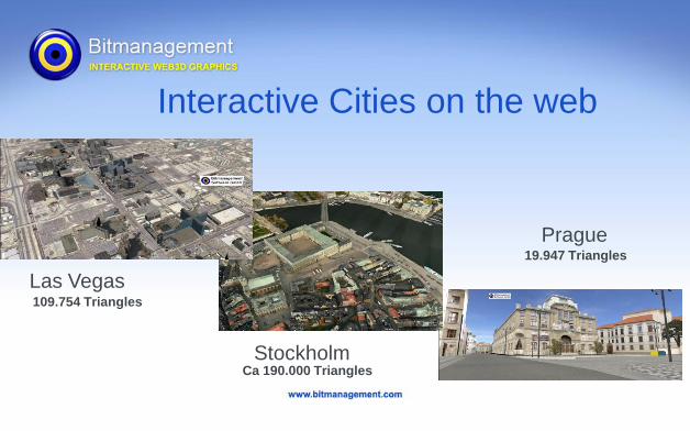
Las Vegas
19.947 Triangles
Ca 190.000 Triangles
109.754 Triangles
Interactive Cities on the web
Stockholm
Prague

3D cities – realtime view
Technology: Complete cities can be mapped in 3D automatically by flyover and visualized in realtime with BS Contact Geo on the Internet. Perception: Highly detailed appearance of the 3D city. High accuracy showing trees, building sites and fully textured houses.

Bertelsmann – 3D Earth

Interactive Soccer Game -
HSV Soccer Arena

Visualization Outdoors
and Indoors

Interior visualization

BS Encrypt – Content Encryption
with strong security

Rapid Enviroment Building
Technology: 3D environments can been constructed within hours semi-automatically from 2D Satellite Images. Usage: Missions can be rehearsed in multi-user sessions over the internet.

Comparison 3D PDF vs X3D
3D PDF X3D
CAD Viewer Acrobat XI Pro BS Contact
CAD Files BREP and Tesselation BREP, Spline and Tesselation
ISO Standard Yes Yes
Security Encryption Encryption
3D Measurements Yes Yes
3D Comments Yes Yes
Compression Only zip grade. X3D binary better
Web enabled No. All Data needs to be
local.
Yes. Data distributed on
servers.
Interactivity Only basic Fully interactive
Platform support Windows, iOS (?) Windows, Linux, iOS,
Android, Mac
Taylor made APPs No Yes
Multi-User No Yes with BS Collaborate
Server
Bitmanagement’s X3D Technology can do similar things as 3DPDF and much more. Advantages: Fully Interactive Fully Web- Enabled Cross-platform: Windows, Mac iOS, Android Cross-browser: IE, Chrome, FF, SF

BS Tiler Automated preparation of data
Automatic tile building and optimization for fast rendering of data derived from point clouds, models and imagery
Import of elevation grid data, grid textures and vectors
Import of ESRI *.shp-files
Triangulation and tile building
Automatic level of detail (LOD) optimization
Data reduction
Tile edge optimization
Output texture formats: JPEG, JPEG 2000, PNG, TGA
and publish exemplar hybrid content

Reading native CityGML Streams -
online and offline

Parcing of large data,
on the 3D earth.

Fast Rendering Optimization Combining Textures - keeping Metainformation

Automated coordinate Transform and positioning
on 3D Globe using EPSG Codes

CityGML databases and X3D visualization
go hand in hand

BS Contact 3D Engine- Your window to your data
Bitmanagement is uniquely suited with existing know-how and X3D software
to elaborate a central and holistic view on your 3D data.
This makes the life cycle of your data,
with actual states, planning states and alternatives interactive, web-enabled,
visible and usable.

Bitmanagement 3D Software – Your 3D engine and tools
Bitmanagement Software GmbH Oberlandstr. 26 82335 Berg near Munich Germany E-Mail: [email protected] Phone : +49 8151971708