Embed Size (px)
Citation preview

TS 10K – Cadastral Boundary Issues
Joseph Owusu and Jonathan A. Quaye Ballard
Satellite Positioning in Customary Land Boundary Demarcation in Peri-urban Ghana.
FIG Congress 2010
Facing the Challenges – Building the Capacity
Sydney, Australia, 11-16 April 2010
1/12
Satellite Positioning (GPS) in Customary Land Boundary Demarcation in
Peri-Urban Ghana
Case Study: Ejisu Paramount Stool land
Joseph OWUSU
1 And Jonathan. A. QUAYE-BALLARD
2.
1Building and Road Research Institute (B.R.R.I), Council for Scientific and Industrial
Research (CSIR). 2Kwame Nkrumah University of Science and Technology (KNUST), Department of
Geomatics Engineering, College of Engineering.
Keywords: Satellite, Global Positioning System (GPS), Customary Land, Survey Pillars
SUMMARY Surveying and mapping, which is the backbone of construction and the foundation of
governmental policy implementation, provides all the necessary data and information
concerning land policies.
In Ghana, the classical method of land surveying and data collection (using compass and tape
measurements) has suffered a number of setbacks such as human errors, time consuming, and
cost prohibitive. A new method of using the satellite or the Global Positioning System (GPS)
technology has been explored.
Parcels of land owned by families and chiefs in Ghana are usually without proper artificial
boundaries and documentation. Few parcels with surveyed pillars are lost over the years as a
result of activities such as farming and construction. This has resulted in customary lands
management problems often leading to serious land disputes and conflicts among natives who
share common boundaries.
The customary land boundary was identified and demarcated by the local people who share a
common boundary. Survey pillars were planted at some selected positions.
With the application of this modern techniques (satellite positioning), the positions of the
customary land boundary owned by the Ejisu paramount stool were observed. The data was
processed and integrated into the new National Geodetic Reference Network (GRN). This has
been documented for successful land administrative purposes both at the National and the
District level. At the completion of the project, it has been proven to the concerned population
that it is futile to shift or destroy boundary markers of any kind or quality. Any such
manipulation shall be easily detected and rectified.
…

TS 10K – Cadastral Boundary Issues
Joseph Owusu and Jonathan A. Quaye Ballard
Satellite Positioning in Customary Land Boundary Demarcation in Peri-urban Ghana.
FIG Congress 2010
Facing the Challenges – Building the Capacity
Sydney, Australia, 11-16 April 2010
2/12
Satellite Positioning (GPS) in Customary Land Boundary Demarcation in
Peri-Urban Ghana
Case Study: Ejisu Paramount Stool land
Joseph OWUSU
1 And Jonathan. A. QUAYE-BALLARD
2.
1. INTRODUCTION
Customary lands have been in existence throughout history. In Ghana, Customary lands are
lands owned by stools, skins, clans, families, etc. Customary lands form about 80% of the
lands in the country. The remaining 20% is individual and state land compulsorily acquired or
occupied over the years in pursuit of the State’s development objectives (Larbi 2006).
Customary land "ownership" refers to the communal possession of rights to use and allocate
land by a group sharing the same cultural identity (Mattingly et al, 2006). Land ownership, in
Ghana, has its origin in absolute “allodial” or permanent title, from which all other lesser titles
on customary land take their roots -that persons other than the owners may have subsidiary or
secondary rights, less than rights of ownership, in customary land; and that the rights of
persons in customary land are derived from and determined by rules of customs of the area in
which the land is located and which are expound by chiefs and elders but which are normally
not written down or officially recorded (Paterson, D.E, 2001).
Customary lands support the daily living of the majority of the people in the country and they
will be insecure the moment it is affected by disputes. The 1992 Constitution of Ghana
recognizes the right of the traditional authorities to manage customary lands. Article 267 (1)
of the 1992 Constitution states “All stool lands in Ghana shall vest in the appropriate stool on
behalf of, and in trust for the subjects of the stool in accordance with customary law and
usage.”
Meanwhile, most of the customary lands have lost their boundaries because the landmarks
and features (e.g. trees, rivers, footpaths, etc), which were used as boundaries, are lost after
long period. Its immediate management, through an improved Land Administration
Programme (LAP) is therefore critical to the socio-economic development of the country.
Sustainability of tenure of lesser titles would largely be improved or guaranteed if boundaries
of customary lands are clearly defined in the field followed by a proper documentation.
2.0 APPROACH TO THE PROJECT.
2.1 Public Education
A series of public awareness campaigns were organized with the LAP officials to educate all
the key stakeholders; chiefs, elders, Town development Committee, etc. (Figure 1).

TS 10K – Cadastral Boundary Issues
Joseph Owusu and Jonathan A. Quaye Ballard
Satellite Positioning in Customary Land Boundary Demarcation in Peri-urban Ghana.
FIG Congress 2010
Facing the Challenges – Building the Capacity
Sydney, Australia, 11-16 April 2010
3/12
f
Fig.1 shows the meetings with the stakeholders during the public campaign.
The campaign was organized to meet the following specific objectives:
a) To educate the people that, the boundary between the paramount stool areas and the
adjoining paramount stools needs to be clearly defined in the field for easy
identification.
b) To provide credible documents, including co-ordinates, with a detailed description of
the boundary, for which the chiefs’ will give their firm undertaking to accept its
location.
c) To gain appreciation for the benefits that the existence of clear boundaries would bring
to the present and future generations and the need to maintain them.
d) To convince the concerned population by word and proof that, thanks to modern
techniques (satellite positioning), it is futile to shift or destroy boundary markers of any kind
or quality. (LAPU, 2008).
Materials such as Site layouts, photomaps and every information that were necessary for the
education were obtained from relevant agencies such as the district offices and recognized
bodies including the chiefs, elders and caretakers as shown in Figure 2.
Fig. 2 The survey team studying the topographical map for the area.

TS 10K – Cadastral Boundary Issues
Joseph Owusu and Jonathan A. Quaye Ballard
Satellite Positioning in Customary Land Boundary Demarcation in Peri-urban Ghana.
FIG Congress 2010
Facing the Challenges – Building the Capacity
Sydney, Australia, 11-16 April 2010
4/12
2.2 Field work
In the execution of the project, labourers were hired from the adjoining communities as a
gesture. This was to give employment to the communities so as to get them to develop interest
in the project, and also to make the knowledge of the existence of the boundary pillars known
to them, (figure 3).
Fig.3 a) Survey Pillar planted insitu.
a. Reconnaissance Survey
Reconnaissance survey of the boundaries was undertaken with the approval of the chiefs,
elders and opinion leaders. This is one of the most important aspects of any survey and must
always be undertaken before any angles or lengths are measured, (Uren & Price, 1994). With
the assistance of the chiefs’ representatives, elders and opinion leaders from interested parties
we arrived at a common boundary.
The process was run to meet the acceptance of the paramount chiefs.
The two types of boundary identified during the reconnaissance survey were:
a) Imaginary line herein referred to as Defined boundary (Db) and
b) Natural feature such as river, stream, and Forest Edge.
The boundaries (Db or Rb) were identified by the Representatives from the Adjoining
Paramount Stools (RAPS). Once the RAPS had agreed upon the common boundary, a survey
station was selected and the preparatory demarcation work begun.
The reconnaissance survey of the boundary (Db) which was carried out involved putting in
pegs at some selected stations at intervals ranging between 0-1km based on the nature of the
boundary as indicated by the RAPS. The surveying team made it a point to be always on the
field with the RAPS.
b. Field Observations
Two teams, comprising six and eight people were created. Each team is made up of a
representative of the chiefs from the towns owning the adjoining lands. The first team was
trained by a technical team to use Geographic Positioning System (GPS) equipment and
surveying techniques. The second team was used as an advance party in clearing the boundary

TS 10K – Cadastral Boundary Issues
Joseph Owusu and Jonathan A. Quaye Ballard
Satellite Positioning in Customary Land Boundary Demarcation in Peri-urban Ghana.
FIG Congress 2010
Facing the Challenges – Building the Capacity
Sydney, Australia, 11-16 April 2010
5/12
line at 2m wide, whiles planting the pillars at the selected stations during the reconnaissance.
Where the line was hitting an economic tree such as cocoa or timber, the tree was avoided and
not cut down.
The survey pillars (beacons) were of dimensions 22.9cm x 22.9cm x 45.7cm, of which
15.2cm was above the ground. They were used where the boundary had been defined by
streams and rivers, (figure 4).
Fig. 4 Precast survey pillars that was planted along the course of the river Banko
The people were trained to use a handheld GPS to Map and detail the stream and its
tributaries. Even though the accuracy in using the handheld was +/-3m, the wide of the stream
on the average was 5m. It was also faster and a large volume of data was captured in no time
compared to the classical method. No boundary monuments were planted for the Rb except
the survey pillars and markers ‘n’tombe’ was erected to indicate the course of all the streams.
This will ensured no boundary disputed whenever the river course is changed through
artificial or natural means.
A boundary monument of dimension 30 x 30 cm with 1.1m above ground level and 0.46m
below the ground were planted at where the boundary happened to be on the dry land (figure
4). At the various transitions points in between monuments, boundary markers (n’tombe)
were planted to help define the boundary. These local trees were recommended by the chiefs
and the indigenous people. The teams were maintained through the duration of the project.

TS 10K – Cadastral Boundary Issues
Joseph Owusu and Jonathan A. Quaye Ballard
Satellite Positioning in Customary Land Boundary Demarcation in Peri-urban Ghana.
FIG Congress 2010
Facing the Challenges – Building the Capacity
Sydney, Australia, 11-16 April 2010
6/12
Fig.4 A typical boundary monument that was planted.
GPS observations were applied to coordinate all the survey pillars together with the boundary
monuments. Where GPS observation was not possible due to canopy, the traverse was
measured from the closest two GPS points. All the survey pillars were erected to conform to
standards and recommendations with the relevant inscriptions.
C. Detailing
Permanent features like roads and the railway lines that cross the boundary at some points
were detail and plotted on the plan as well. Also structures like houses that are so close to the
boundaries were detail. All the farms that lie along the boundaries were captured and the
names of the owners were recorded on the field books. The farmers who live along the
boundary were supposed to serve as watch dogs.
3.0 RESULTS:
The GPS data observed was processed using software’s like Trimble Total control and Survey
spectrum. The data was integrated into the new National Geodetic Reference Network (GRN),
after which a map was generated in Autodesk land desktop. The data was imported into
ArcMap for the needed spatial analysis and a database was created. A small scale map at
1:50,000 was plotted. The positions of all the boundary markers of all kinds were also noted
in the field books as well as on map (figure 5). The data below shows an example of the
handheld GPS data that was captured for the Banko River and its tributaries.
TS 10K – Cadastral Boundary Issues
Joseph Owusu and Jonathan A. Quaye Ballard
Satellite Positioning in Customary Land Boundary Demarcation in Peri-urban Ghana.
FIG Congress 2010
Facing the Challenges – Building the Capacity
Sydney, Australia, 11-16 April 2010
7/12
Table 1. Processed GPS data from the handheld
P Easting(m) Northern(m)
1 672749 714782
2 683820 725873
3 683849 725854
4 683849 725845
5 683861 725840
6 683871 725835
7 683880 725830
8 683886 725824
9 683893 725816
10 683899 725807
11 683907 725801
12 683916 725798
13 683926 725794
14 683930 725786
15 683923 725779
16 683915 725772
17 683908 725765
18 683900 725759
19 683899 725757
20 683779 725061

TS 10K – Cadastral Boundary Issues
Joseph Owusu and Jonathan A. Quaye Ballard
Satellite Positioning in Customary Land Boundary Demarcation in Peri-urban Ghana.
FIG Congress 2010
Facing the Challenges – Building the Capacity
Sydney, Australia, 11-16 April 2010
8/12
FRO
M K
UM
ASI
TO AC
CRA
SCALE:
1:25,000
(METRIC, UTM)
MARCH. 2008DATE:
LAND
ADMINISTRATION
PROJECT(LAP 1)
PROJECT:
MINISTRY OF LANDS,
FORESTRY AND MINES
CLIENT:
CUSTOMARY BOUNDARY
DEMARCATION-EJISU
CSIR/BRRICONSULTANT:
JUABEN STOOL LAND
EJIS
U STOOL LAND
FRO
M A
SIS
IRIW
A
TO
BO
AM
AD
UM
ASE
RIV
ER
KUNTENASE
RIV
ER
H
WE
RE
PUMP HOUSEWELL
RIVER TWEMETWEME
RAIL
RIV
ER
RIVER BANKO
TEAK PLANTATION
COCONUT PLANTATION
SGA/14/07/2/6
SGA/14/07/2/1
SGA/14/07/1/1
SGA/14/07/2/2
SGA/14/07/2/3
SGA/14/07/2/4
SGA/14/07/2/5
SGA/14/07/2/7
SGA/14/07/2/8
SGA/14/07/2/9
SGA/14/07/2/10
SGA/14/07/2/11
SGA/14/07/2/12
SGA/14/07/2/13
SGA/14/07/2/14
SGA/14/07/2/15
SGA/14/07/2/17
SGA/14/07/2/16
SGA/14/07/2/18
SGA/14/07/2/19
SGA/14/07/2/20
SGA/14/07/2/21
SGA/14/07/2/22
SGA/14/07/2/23
SGA/14/07/2/24
SGA/14/07/2/25
SGA/14/07/2/26
SGA/14/07/2/27
SGA/14/07/2/28
SGA/14/07/2/29
SGA/14/07/2/30
SGA/14/07/2/32
SGA/14/07/2/33
SGA/14/07/2/35
SGA/14/07/2/37
SGA/14/07/2/38
SGA/14/07/2/39
SGA/14/07/2/40
SGA/14/07/2/41
SGA/14/07/2/42
SGA/14/07/2/43
SGA/14/07/2/36
RIV
ER
RIV
ER
KO
KR
OB
OA
RIV
ER
RIV
ER
ADAW
IA
RIVER BENA
RIV
ER
RIVER BRUKRUWA
BDP4
BDP5
BDP6
BDP7
VB21
BDP2
BDP1
JUABEN STOOL LAND
LIN
E
HW
ER
E
LIN
E
SUPAN
BANKO
ABE
TR
EN
SUA
BO
HY
EN
RAIL
SGA/14/07/2/31
SGA/14/07/2/34
LEGEND
PLANTATION
BOUNDARY
STREAM
RAILWAY
LINE
KU
MA
SI S
TO
OL
LA
ND
STOOL LAND
676000 E 678000 E 680000 E 682000 E 684000 E 686000 E
724000 N
726000 N
732000 N
730000 N
728000 N
734000 N
736000 N
738000 N
740000 N676000 E 678000 E 680000 E 682000 E 684000 E 686000 E
726000 N
728000 N
724000 N
730000 N
732000 N
734000 N
736000 N
738000 N
740000 N
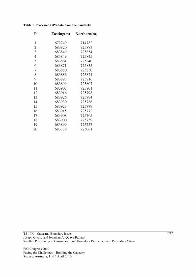
Fig.5 the boundary after phase 1 for the Ejisu Paramount Stool land.

TS 10K – Cadastral Boundary Issues
Joseph Owusu and Jonathan A. Quaye Ballard
Satellite Positioning in Customary Land Boundary Demarcation in Peri-urban Ghana.
FIG Congress 2010
Facing the Challenges – Building the Capacity
Sydney, Australia, 11-16 April 2010
9/12
4.0 DISCUSSIONS:
4.1 Customary boundary Demarcation:
With the help of the GPS technique, all the positions of the boundary pillars were fixed
irrespective of time of the day, weather, position etc. The river corridor was also capture with
the handheld GPS. All the individual farms along the boundary were captured by the GPS and
their positions indicated in the final drawings. Apart from the accuracy in using this
equipment, the people appreciated the fact that it is very easy to use and more time efficient
than using the Topographical Maps and recording information by hand. It is also futile to shift
or destroy boundary markers of any kind or quality.
4.2 The Rural Household
Throughout the project period, it was realised that despite continuing urbanisation, larger
percentage of the populace in the country still live in rural areas. No matter how poor a
household, it has an equal share of rights, or are co-owners in the customary land system. This
implies that, the rural household incomes are derived mainly from the land tenure system. The
people accepted that, the existence of clear boundaries would benefit the present and future
generations and so the need to maintain them.
4.2 The government The State needs the system to be nationally uniform and sustainable; a basis for implementing
local taxation, land use and building control and for the provision of infrastructure eg. the
Inland port and the Free Zone.
5.0 BENEFITS/ PROGRESS
Identification of the customary boundary will contribute to economic development and
sustainable livelihoods by strengthening rights in the customary lands by removing
uncertainty (disputes) especially with those that they share common boundary, and by
encouraging:
a. actions by rural households to: increase production of agricultural goods; lease, rent and
share crop land; manage and use natural resources for household provisioning (food and fuel),
medicinal plants, craft production, building; invest in local economic development via small
enterprises; participate in development projects jointly with private investors; adopt peaceful
and legal means for resolving land related disputes rather than resort to land invasion and
violence(Adams et al ,1999);
b. actions by government at different levels to: provide infrastructure and services, and
invest in development projects, particularly housing; and, on the understanding that the
investment is secure.
c. actions by the private sector to: invest in eco-tourism, forestry and agricultural projects as
there is the assurance that they will not be evicted without compensation, their children can
inherit the property; the ability to sell or otherwise transfer the property; the ability to borrow
money using the property as collateral; properties to be serviced with such things as water,

TS 10K – Cadastral Boundary Issues
Joseph Owusu and Jonathan A. Quaye Ballard
Satellite Positioning in Customary Land Boundary Demarcation in Peri-urban Ghana.
FIG Congress 2010
Facing the Challenges – Building the Capacity
Sydney, Australia, 11-16 April 2010
10/12
electricity and the upgrading of roads; and an inexpensive and easily accessible system of
administering property rights.
6.0 CONCLUSIONS:
Composite plans showing boundaries of adjoining stool lands have been submitted for
validation and acceptance by the respective paramount councils at public forum? Where there
were changes during deliberations, they were effected accordingly especially the tributaries
where the river/stream is the boundary.
A draft report was also submitted for discussion, after which the final drawings together with
all field notes and sketches with the approval of the Regional Surveyor have been submitted
to the Client.
Recommendations
Policy-makers
• Need to think in terms of a long transition period from customary tenure to freehold
title and how land will be administered during this time.
• A wider range of the public needs to get involved in debates about land.
The Ministry of Lands:
• Should recognise and engage with the institutions of customary tenure (Land
registries) especially the Secretariat being set up by the LAP for the Traditional
Councils (Decentralization).
• Should support the LAP in the process of Customary Boundary demarcation and be
ready to administer the outcome.
The local Government:
• Can sensitise communities about the pros and cons of acquiring certificates of
customary ownership. These should be issued to those who apply. The certificates
need to become a ‘living’ document, amended as land is bought, and as people are
born and die.
• Can set up a system for recording land transactions on ‘customary’ land through the
Traditional Council’s Secretariat.
References

TS 10K – Cadastral Boundary Issues
Joseph Owusu and Jonathan A. Quaye Ballard
Satellite Positioning in Customary Land Boundary Demarcation in Peri-urban Ghana.
FIG Congress 2010
Facing the Challenges – Building the Capacity
Sydney, Australia, 11-16 April 2010
11/12
Mattingly, M. & Durand-Lasserve, A., (2006), Land for Housing Poor People in Africa
through Neo-Customary Processes: An Effective Alternative to Formal Systems?
LAPU, (2007), Technical specifications and terms of reference for customary boundary,
Ghana
Kotey, N.A. & Yeboah, M.O. (2003), Access to Justice Series no.1, Peri-Urbanism, Land
Relations and Women in Ghana.
Uren, J. & Price, W.F.(1994) Surveying for Engineers. Pp.228.
Asenso, D., Owusu, J., Amoafo,Y. & Yeboah, F. (2008).Final Report on Customary
Boundary Demarcation- Ejisu, Ghana. Ministry of Land, Forestry & Mines.
Paterson, D.E (2001), Some thoughts about customary land. South Pacific pp2.
Jardinet, S. (2004), Capacity development and PGIS for land demarcation: innovations from
Nicaragua. Nicaragua.
Adams, M., Sibanda, S. &Turner, S. (1999), Land Tenure Reform and Rural Livelihoods in
Southern Africa. Pp.6-7. Quaye, B. (2007), Overview of the Ghana land Administration
project-(LAP). A presentation
BIOGRAPHICAL NOTES
Primary Speaker (Joseph Owusu)
1. Joseph Owusu is a Research Scientist at the Building and Road Research Institute (BRRI)
of the Council for Scientific and Industrial Research (CSIR), Ghana and is currently a
Geomatics Engineer. He has been involving in projects covering land titles and disputed
parcels of land. He has been attending and presenting a lot of conference papers both local
and international. Examples are 1. FIG regional conference in Accra-Ghana in 2006 and 2.
XXIII International FIG Congress in Germany (2006). www.fig2006.de. 2. Joint CIG/ISPRs
conference on Geomatics for Disaster and Risk Management in 2007 in Toronto. He has B.Sc.
in Geodetic Engineering and Mphil in Geomatics Engineering from the Kwame University of
Science and Technology, Kumasi- Ghana.
Contact: Building and Road research Institute, Box 40, UST. Kumasi – Ghana,
E-mail: [email protected]. Mobile: +233-244-274114.
2. J. A. Quaye-Ballard is a Lecturer at the Kwame Nkrumah University of Science and
Technology in the Department of Geomatic Engineering, Faculty of Civil and Geomatic
Engineering, KNUST), Kumasi, Ghana.He has attended a lot of conferences and presented
papers both local and International.
Contact: [email protected]. Kwame Nkrumah University of Science And
Technology, (College of Engineering) Private Mail Bag, UST, Kumasi-Ghana. W/Africa

TS 10K – Cadastral Boundary Issues
Joseph Owusu and Jonathan A. Quaye Ballard
Satellite Positioning in Customary Land Boundary Demarcation in Peri-urban Ghana.
FIG Congress 2010
Facing the Challenges – Building the Capacity
Sydney, Australia, 11-16 April 2010
12/12