Embed Size (px)
Citation preview
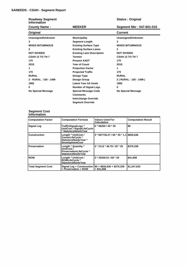
SANEEDS - CSAH - Segment Report
Roadway SegmentInformation
Status : Original
County Name : MEEKER Segment Nbr : 047-601-010
Original Current
Unassigned/Unknown Municipality Unassigned/Unknown
3 Segment Length 3
MIXED BITUMINOUS Existing Surface Type MIXED BITUMINOUS
2 Existing Surface Lanes 2
NOT DIVIDED Existing Lane Description NOT DIVIDED
CSAH 12 TO TH 7 Termini CSAH 12 TO TH 7
170 Present AADT 170
2015 Year of Count 2015
1 Projection Factor 1
170 Projected Traffic 170
RURAL Design Type RURAL
2 - RURAL : 150 - 1499 Design Group 2 ( RURAL : 150 - 1499 )
1992 Latest Year SA funds 1992
0 Number of Signal Legs 0
No Special Message Special Message Code No Special Message
Comments
Interchange Override
Segment Override
Segment CostInformation
Computation Factor Computation Formula Values Used ForCalculation
Computation Result
Signal Leg TrafficSignalLegs *UnitCost / SignalLifeCycle* StatutoryNeedsYear
0 * 56250 / 40 * 25 $0
Construction Length * UnitCost /ConstrLifeCycle *StatutoryNeedsYear *DevelopmentCost
3 * 607735.27 / 60 * 25 * 1.1 $835,636
Preservation Length * Quantity *UnitCost /PreservationLifeCycle *StatutoryNeedsYear
3 * 2112 * 46.76 / 20 * 25 $370,339
ROW Length * UnitCost /ROWLifeCycle *StatutoryNeedsYear
3 * 33326.01 / 60 * 25 $41,658
Total Segment Cost Signal Leg + Construction+ Preservation + ROW
$0 + $835,636 + $370,339+ $41,658
$1,247,633
SANEEDS - CSAH - Segment Report
Roadway SegmentInformation
Status : Original
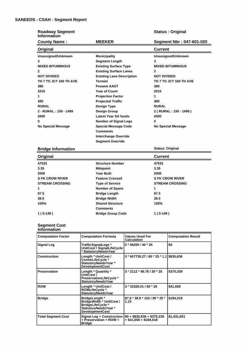
County Name : MEEKER Segment Nbr : 047-601-020
Original Current
Unassigned/Unknown Municipality Unassigned/Unknown
3 Segment Length 3
MIXED BITUMINOUS Existing Surface Type MIXED BITUMINOUS
2 Existing Surface Lanes 2
NOT DIVIDED Existing Lane Description NOT DIVIDED
TH 7 TO JCT 160 TH AVE Termini TH 7 TO JCT 160 TH AVE
380 Present AADT 380
2015 Year of Count 2015
1 Projection Factor 1
380 Projected Traffic 380
RURAL Design Type RURAL
2 - RURAL : 150 - 1499 Design Group 2 ( RURAL : 150 - 1499 )
2000 Latest Year SA funds 2000
0 Number of Signal Legs 0
No Special Message Special Message Code No Special Message
Comments
Interchange Override
Segment Override
Bridge Information Status: Original
Original Current
47533 Structure Number 47533
3.35 Milepoint 3.35
2000 Year Built 2000
S FK CROW RIVER Feature Crossed S FK CROW RIVER
STREAM CROSSING Type of Service STREAM CROSSING
1 Number of Spans 1
87.5 Bridge Length 87.5
38.5 Bridge Width 38.5
100% Shared Structure 100%
Comments
1 ( 0-149 ) Bridge Group Code 1 ( 0-149 )
Segment CostInformation
Computation Factor Computation Formula Values Used ForCalculation
Computation Result
Signal Leg TrafficSignalLegs *UnitCost / SignalLifeCycle* StatutoryNeedsYear
0 * 56250 / 40 * 25 $0
Construction Length * UnitCost /ConstrLifeCycle *StatutoryNeedsYear *DevelopmentCost
3 * 607735.27 / 60 * 25 * 1.1 $835,636
Preservation Length * Quantity *UnitCost /PreservationLifeCycle *StatutoryNeedsYear
3 * 2112 * 46.76 / 20 * 25 $370,339
ROW Length * UnitCost /ROWLifeCycle *StatutoryNeedsYear
3 * 33326.01 / 60 * 25 $41,658
Bridge BridgeLength *BridgeWidth * UnitCost /BridgeLifeCycle *StatutoryNeedsYear *DevelopmentCost
87.5 * 38.5 * 152 / 80 * 25 *1.15
$184,018
Total Segment Cost Signal Leg + Construction+ Preservation + ROW +Bridge
$0 + $835,636 + $370,339+ $41,658 + $184,018
$1,431,651

SANEEDS - CSAH - Segment Report
Roadway SegmentInformation
Status : Original
County Name : MEEKER Segment Nbr : 047-601-025
Original Current
Unassigned/Unknown Municipality Unassigned/Unknown
3.8 Segment Length 3.8
MIXED BITUMINOUS Existing Surface Type MIXED BITUMINOUS
2 Existing Surface Lanes 2
NOT DIVIDED Existing Lane Description NOT DIVIDED
JCT 160TH AVE TO JCT CSAH 28 Termini JCT 160TH AVE TO JCT CSAH 28
900 Present AADT 900
2015 Year of Count 2015
1 Projection Factor 1
900 Projected Traffic 900
RURAL Design Type RURAL
2 - RURAL : 150 - 1499 Design Group 2 ( RURAL : 150 - 1499 )
2001 Latest Year SA funds 2001
0 Number of Signal Legs 0
No Special Message Special Message Code No Special Message
Comments
Interchange Override
Segment Override
Segment CostInformation
Computation Factor Computation Formula Values Used ForCalculation
Computation Result
Signal Leg TrafficSignalLegs *UnitCost / SignalLifeCycle* StatutoryNeedsYear
0 * 56250 / 40 * 25 $0
Construction Length * UnitCost /ConstrLifeCycle *StatutoryNeedsYear *DevelopmentCost
3.8 * 607735.27 / 60 * 25 *1.1
$1,058,472
Preservation Length * Quantity *UnitCost /PreservationLifeCycle *StatutoryNeedsYear
3.8 * 2112 * 46.76 / 20 * 25 $469,096
ROW Length * UnitCost /ROWLifeCycle *StatutoryNeedsYear
3.8 * 33326.01 / 60 * 25 $52,766
Total Segment Cost Signal Leg + Construction+ Preservation + ROW
$0 + $1,058,472 + $469,096+ $52,766
$1,580,334
SANEEDS - CSAH - Segment Report
Roadway SegmentInformation
Status : Original
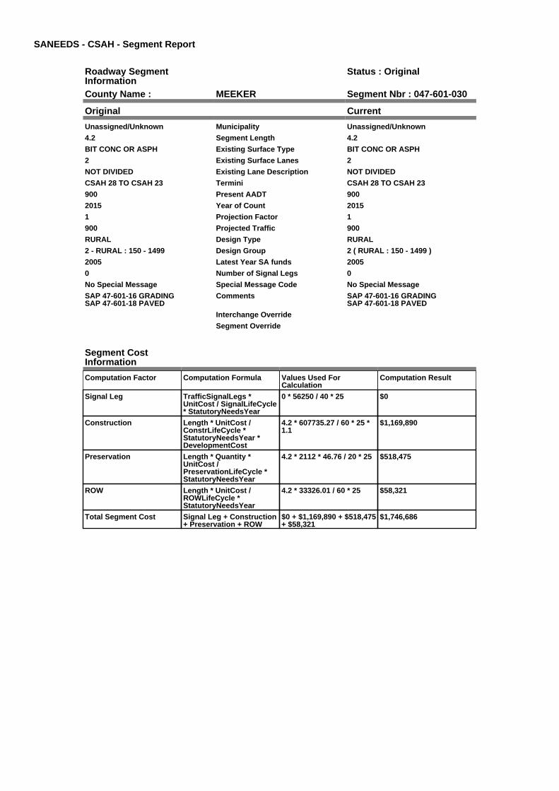
County Name : MEEKER Segment Nbr : 047-601-030
Original Current
Unassigned/Unknown Municipality Unassigned/Unknown
4.2 Segment Length 4.2
BIT CONC OR ASPH Existing Surface Type BIT CONC OR ASPH
2 Existing Surface Lanes 2
NOT DIVIDED Existing Lane Description NOT DIVIDED
CSAH 28 TO CSAH 23 Termini CSAH 28 TO CSAH 23
900 Present AADT 900
2015 Year of Count 2015
1 Projection Factor 1
900 Projected Traffic 900
RURAL Design Type RURAL
2 - RURAL : 150 - 1499 Design Group 2 ( RURAL : 150 - 1499 )
2005 Latest Year SA funds 2005
0 Number of Signal Legs 0
No Special Message Special Message Code No Special Message
SAP 47-601-16 GRADINGSAP 47-601-18 PAVED
Comments SAP 47-601-16 GRADINGSAP 47-601-18 PAVED
Interchange Override
Segment Override
Segment CostInformation
Computation Factor Computation Formula Values Used ForCalculation
Computation Result
Signal Leg TrafficSignalLegs *UnitCost / SignalLifeCycle* StatutoryNeedsYear
0 * 56250 / 40 * 25 $0
Construction Length * UnitCost /ConstrLifeCycle *StatutoryNeedsYear *DevelopmentCost
4.2 * 607735.27 / 60 * 25 *1.1
$1,169,890
Preservation Length * Quantity *UnitCost /PreservationLifeCycle *StatutoryNeedsYear
4.2 * 2112 * 46.76 / 20 * 25 $518,475
ROW Length * UnitCost /ROWLifeCycle *StatutoryNeedsYear
4.2 * 33326.01 / 60 * 25 $58,321
Total Segment Cost Signal Leg + Construction+ Preservation + ROW
$0 + $1,169,890 + $518,475+ $58,321
$1,746,686

SANEEDS - CSAH - Segment Report
Roadway SegmentInformation
Status : Original
County Name : MEEKER Segment Nbr : 047-601-040
Original Current
Unassigned/Unknown Municipality Unassigned/Unknown
2.9 Segment Length 2.9
MIXED BITUMINOUS Existing Surface Type MIXED BITUMINOUS
2 Existing Surface Lanes 2
NOT DIVIDED Existing Lane Description NOT DIVIDED
CSAH 23 TO SO LIMS LITCHFIELD Termini CSAH 23 TO SO LIMS LITCHFIELD
1450 Present AADT 1450
2015 Year of Count 2015
1 Projection Factor 1
1450 Projected Traffic 1450
RURAL Design Type RURAL
2 - RURAL : 150 - 1499 Design Group 2 ( RURAL : 150 - 1499 )
2005 Latest Year SA funds 2005
0 Number of Signal Legs 0
No Special Message Special Message Code No Special Message
RESURFACED UNDER SAP 47-601-018
Comments RESURFACED UNDER SAP 47-601-018
Interchange Override
Segment Override
Segment CostInformation
Computation Factor Computation Formula Values Used ForCalculation
Computation Result
Signal Leg TrafficSignalLegs *UnitCost / SignalLifeCycle* StatutoryNeedsYear
0 * 56250 / 40 * 25 $0
Construction Length * UnitCost /ConstrLifeCycle *StatutoryNeedsYear *DevelopmentCost
2.9 * 607735.27 / 60 * 25 *1.1
$807,781
Preservation Length * Quantity *UnitCost /PreservationLifeCycle *StatutoryNeedsYear
2.9 * 2112 * 46.76 / 20 * 25 $357,995
ROW Length * UnitCost /ROWLifeCycle *StatutoryNeedsYear
2.9 * 33326.01 / 60 * 25 $40,269
Total Segment Cost Signal Leg + Construction+ Preservation + ROW
$0 + $807,781 + $357,995+ $40,269
$1,206,045

SANEEDS - CSAH - Segment Report
Roadway SegmentInformation
Status : Original
County Name : MEEKER Segment Nbr : 047-601-041
Original Current
LITCHFIELD Municipality LITCHFIELD
0.5 Segment Length 0.5
MIXED BITUMINOUS Existing Surface Type MIXED BITUMINOUS
2 Existing Surface Lanes 2
NOT DIVIDED Existing Lane Description NOT DIVIDED
SO LIM LITCHFIELD TO N LIMSLITCHFIELD
Termini SO LIM LITCHFIELD TO N LIMSLITCHFIELD
2000 Present AADT 2000
2015 Year of Count 2015
1 Projection Factor 1
2000 Projected Traffic 2000
RURAL Design Type RURAL
3 - RURAL : 1500 - 6999 Design Group 3 ( RURAL : 1500 - 6999 )
2005 Latest Year SA funds 2005
0 Number of Signal Legs 0
No Special Message Special Message Code No Special Message
RESURFACED UNDER SAP 47-601-018
Comments RESURFACED UNDER SAP 47-601-018
Interchange Override
Segment Override
Segment CostInformation
Computation Factor Computation Formula Values Used ForCalculation
Computation Result
Signal Leg TrafficSignalLegs *UnitCost / SignalLifeCycle* StatutoryNeedsYear
0 * 56250 / 40 * 25 $0
Construction Length * UnitCost /ConstrLifeCycle *StatutoryNeedsYear *DevelopmentCost
0.5 * 922582.78 / 60 * 25 *1.1
$211,425
Preservation Length * Quantity *UnitCost /PreservationLifeCycle *StatutoryNeedsYear
0.5 * 2376 * 46.76 / 20 * 25 $69,439
ROW Length * UnitCost /ROWLifeCycle *StatutoryNeedsYear
0.5 * 72889.99 / 60 * 25 $15,185
Total Segment Cost Signal Leg + Construction+ Preservation + ROW
$0 + $211,425 + $69,439 +$15,185
$296,049

SANEEDS - CSAH - Segment Report
Roadway SegmentInformation
Status : Original
County Name : MEEKER Segment Nbr : 047-601-042
Original Current
Unassigned/Unknown Municipality Unassigned/Unknown
0.4 Segment Length 0.4
MIXED BITUMINOUS Existing Surface Type MIXED BITUMINOUS
2 Existing Surface Lanes 2
NOT DIVIDED Existing Lane Description NOT DIVIDED
0.10 MILES NORTH OF 255THSTREET TO 260TH STREET
Termini 0.10 MILES NORTH OF 255THSTREET TO 260TH STREET
2000 Present AADT 2000
2015 Year of Count 2015
1 Projection Factor 1
2000 Projected Traffic 2000
RURAL Design Type RURAL
3 - RURAL : 1500 - 6999 Design Group 3 ( RURAL : 1500 - 6999 )
2005 Latest Year SA funds 2005
0 Number of Signal Legs 0
No Special Message Special Message Code No Special Message
RESURFACED UNDER SAP 47-601-018
Comments RESURFACED UNDER SAP 47-601-018
Interchange Override
Segment Override
Segment CostInformation
Computation Factor Computation Formula Values Used ForCalculation
Computation Result
Signal Leg TrafficSignalLegs *UnitCost / SignalLifeCycle* StatutoryNeedsYear
0 * 56250 / 40 * 25 $0
Construction Length * UnitCost /ConstrLifeCycle *StatutoryNeedsYear *DevelopmentCost
0.4 * 922582.78 / 60 * 25 *1.1
$169,140
Preservation Length * Quantity *UnitCost /PreservationLifeCycle *StatutoryNeedsYear
0.4 * 2376 * 46.76 / 20 * 25 $55,551
ROW Length * UnitCost /ROWLifeCycle *StatutoryNeedsYear
0.4 * 72889.99 / 60 * 25 $12,148
Total Segment Cost Signal Leg + Construction+ Preservation + ROW
$0 + $169,140 + $55,551 +$12,148
$236,839

SANEEDS - CSAH - Segment Report
Roadway SegmentInformation
Status : Original
County Name : MEEKER Segment Nbr : 047-601-050
Original Current
Unassigned/Unknown Municipality Unassigned/Unknown
0.5 Segment Length 0.5
MIXED BITUMINOUS Existing Surface Type MIXED BITUMINOUS
2 Existing Surface Lanes 2
NOT DIVIDED Existing Lane Description NOT DIVIDED
260TH STREET TO S LIMSLITCHFIELD
Termini 260TH STREET TO S LIMSLITCHFIELD
1250 Present AADT 1250
2015 Year of Count 2015
1 Projection Factor 1
1250 Projected Traffic 1250
RURAL Design Type RURAL
2 - RURAL : 150 - 1499 Design Group 2 ( RURAL : 150 - 1499 )
2005 Latest Year SA funds 2005
0 Number of Signal Legs 0
No Special Message Special Message Code No Special Message
RESURFACED UNDER SAP 47-601-018
Comments RESURFACED UNDER SAP 47-601-018
Interchange Override
Segment Override
Culvert Information Status: Original
Original Current
92619 Structure Number 92619
18.29 Milepoint 18.29
1967 Year Built 1967
JEWETT CREEK (CD # 19) Feature Crossed JEWETT CREEK (CD # 19)
Type of Service
1 Number of Barrels 1
10 Culvert Width 10
7 Culvert Height 7
89 Culvert Length 89
52.0004009 Area of Waterway Opening 52.0004009
100% Shared Structure 100%
Comments
1 Culvert Group Code 1
RailRoadCrossingInformation
Status: Original
Original Current
BURLINGTON NORTHERN SANTAFE RAILWAY
RailRoad Name BURLINGTON NORTHERN SANTAFE RAILWAY
067811L USDOT Number 067811L
0.3 Located at Milepoint 0.3
1 Mainline Tracks 1
SIGNALS ONLY Protection Type SIGNALS ONLY
1987 Last Year Protection Upgraded 1987
32 Crossing Length 32
Last Year Surfaced
100% Percentage of Cost 100%
Comments
Segment CostInformation
Computation Factor Computation Formula Values Used ForCalculation
Computation Result
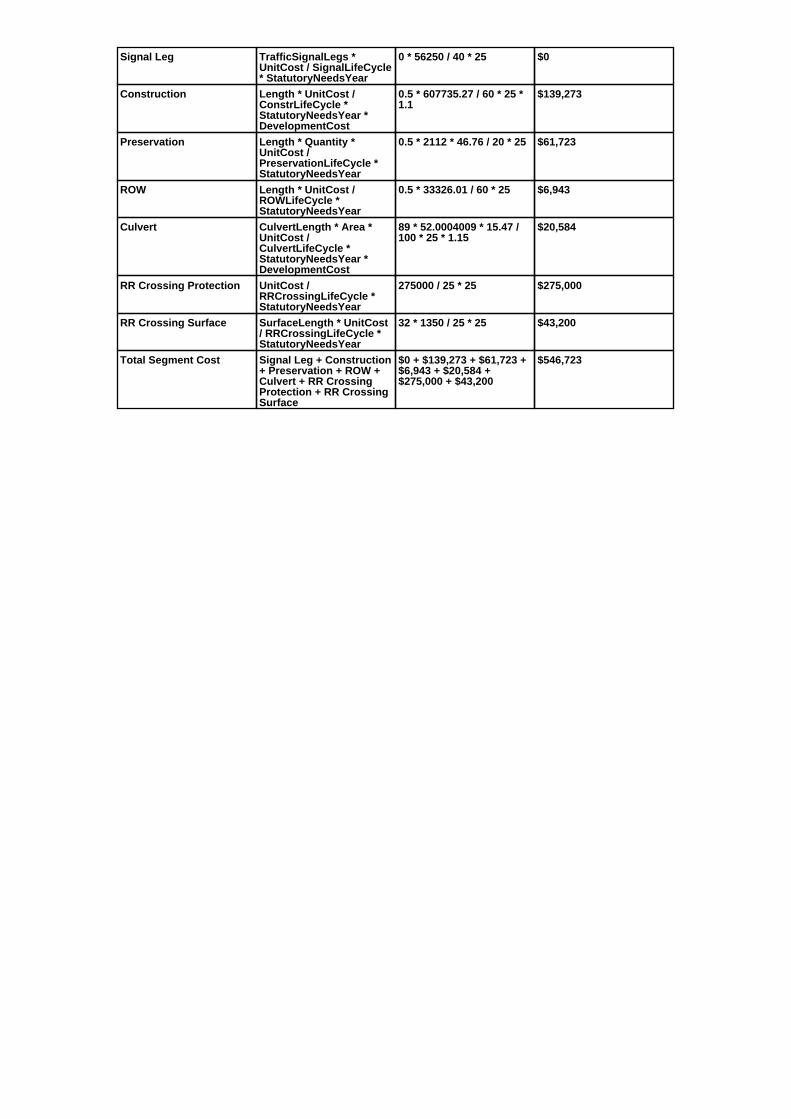
Signal Leg TrafficSignalLegs *UnitCost / SignalLifeCycle* StatutoryNeedsYear
0 * 56250 / 40 * 25 $0
Construction Length * UnitCost /ConstrLifeCycle *StatutoryNeedsYear *DevelopmentCost
0.5 * 607735.27 / 60 * 25 *1.1
$139,273
Preservation Length * Quantity *UnitCost /PreservationLifeCycle *StatutoryNeedsYear
0.5 * 2112 * 46.76 / 20 * 25 $61,723
ROW Length * UnitCost /ROWLifeCycle *StatutoryNeedsYear
0.5 * 33326.01 / 60 * 25 $6,943
Culvert CulvertLength * Area *UnitCost /CulvertLifeCycle *StatutoryNeedsYear *DevelopmentCost
89 * 52.0004009 * 15.47 /100 * 25 * 1.15
$20,584
RR Crossing Protection UnitCost /RRCrossingLifeCycle *StatutoryNeedsYear
275000 / 25 * 25 $275,000
RR Crossing Surface SurfaceLength * UnitCost/ RRCrossingLifeCycle *StatutoryNeedsYear
32 * 1350 / 25 * 25 $43,200
Total Segment Cost Signal Leg + Construction+ Preservation + ROW +Culvert + RR CrossingProtection + RR CrossingSurface
$0 + $139,273 + $61,723 +$6,943 + $20,584 +$275,000 + $43,200
$546,723

SANEEDS - CSAH - Segment Report
Roadway SegmentInformation
Status : Original
County Name : MEEKER Segment Nbr : 047-601-060
Original Current
LITCHFIELD Municipality LITCHFIELD
0.04 Segment Length 0.04
MIXED BITUMINOUS Existing Surface Type MIXED BITUMINOUS
2 Existing Surface Lanes 2
NOT DIVIDED Existing Lane Description NOT DIVIDED
S LIMS LITCHFIELD TO CSAH 11 Termini S LIMS LITCHFIELD TO CSAH 11
1250 Present AADT 1250
2015 Year of Count 2015
1 Projection Factor 1
1250 Projected Traffic 1250
RURAL Design Type RURAL
2 - RURAL : 150 - 1499 Design Group 2 ( RURAL : 150 - 1499 )
2005 Latest Year SA funds 2005
0 Number of Signal Legs 0
No Special Message Special Message Code No Special Message
RESURFACED UNDER SAP 47-601-018
Comments RESURFACED UNDER SAP 47-601-018
Interchange Override
Segment Override
Segment CostInformation
Computation Factor Computation Formula Values Used ForCalculation
Computation Result
Signal Leg TrafficSignalLegs *UnitCost / SignalLifeCycle* StatutoryNeedsYear
0 * 56250 / 40 * 25 $0
Construction Length * UnitCost /ConstrLifeCycle *StatutoryNeedsYear *DevelopmentCost
0.04 * 607735.27 / 60 * 25 *1.1
$11,142
Preservation Length * Quantity *UnitCost /PreservationLifeCycle *StatutoryNeedsYear
0.04 * 2112 * 46.76 / 20 * 25 $4,938
ROW Length * UnitCost /ROWLifeCycle *StatutoryNeedsYear
0.04 * 33326.01 / 60 * 25 $555
Total Segment Cost Signal Leg + Construction+ Preservation + ROW
$0 + $11,142 + $4,938 +$555
$16,635

SANEEDS - CSAH - Segment Report
Roadway SegmentInformation
Status : Original
County Name : MEEKER Segment Nbr : 047-602-010
Original Current
Unassigned/Unknown Municipality Unassigned/Unknown
0.4 Segment Length 0.4
MIXED BITUMINOUS Existing Surface Type MIXED BITUMINOUS
2 Existing Surface Lanes 2
NOT DIVIDED Existing Lane Description NOT DIVIDED
TH 24 TO 315TH STREET Termini TH 24 TO 315TH STREET
680 Present AADT 680
2015 Year of Count 2015
1 Projection Factor 1
680 Projected Traffic 680
RURAL Design Type RURAL
2 - RURAL : 150 - 1499 Design Group 2 ( RURAL : 150 - 1499 )
1996 Latest Year SA funds 1996
0 Number of Signal Legs 0
No Special Message Special Message Code No Special Message
Comments
Interchange Override
Segment Override
Segment CostInformation
Computation Factor Computation Formula Values Used ForCalculation
Computation Result
Signal Leg TrafficSignalLegs *UnitCost / SignalLifeCycle* StatutoryNeedsYear
0 * 56250 / 40 * 25 $0
Construction Length * UnitCost /ConstrLifeCycle *StatutoryNeedsYear *DevelopmentCost
0.4 * 607735.27 / 60 * 25 *1.1
$111,418
Preservation Length * Quantity *UnitCost /PreservationLifeCycle *StatutoryNeedsYear
0.4 * 2112 * 46.76 / 20 * 25 $49,379
ROW Length * UnitCost /ROWLifeCycle *StatutoryNeedsYear
0.4 * 33326.01 / 60 * 25 $5,554
Total Segment Cost Signal Leg + Construction+ Preservation + ROW
$0 + $111,418 + $49,379 +$5,554
$166,351

SANEEDS - CSAH - Segment Report
Roadway SegmentInformation
Status : Original
County Name : MEEKER Segment Nbr : 047-602-011
Original Current
Unassigned/Unknown Municipality Unassigned/Unknown
0.3 Segment Length 0.3
MIXED BITUMINOUS Existing Surface Type MIXED BITUMINOUS
2 Existing Surface Lanes 2
NOT DIVIDED Existing Lane Description NOT DIVIDED
315TH STREET TO 320TH STREET(TWP RD 127)
Termini 315TH STREET TO 320TH STREET(TWP RD 127)
680 Present AADT 680
2015 Year of Count 2015
1 Projection Factor 1
680 Projected Traffic 680
RURAL Design Type RURAL
2 - RURAL : 150 - 1499 Design Group 2 ( RURAL : 150 - 1499 )
1996 Latest Year SA funds 1996
0 Number of Signal Legs 0
No Special Message Special Message Code No Special Message
Comments
Interchange Override
Segment Override
Bridge Information Status: Original
Original Current
47524 Structure Number 47524
0.43 Milepoint 0.43
1985 Year Built 1985
N FK CROW RIVER Feature Crossed N FK CROW RIVER
Type of Service
Number of Spans
160 Bridge Length 160
38.2 Bridge Width 38.2
100% Shared Structure 100%
Comments
2 ( 150-999,999 ) Bridge Group Code 2 ( 150-999,999 )
Segment CostInformation
Computation Factor Computation Formula Values Used ForCalculation
Computation Result
Signal Leg TrafficSignalLegs *UnitCost / SignalLifeCycle* StatutoryNeedsYear
0 * 56250 / 40 * 25 $0
Construction Length * UnitCost /ConstrLifeCycle *StatutoryNeedsYear *DevelopmentCost
0.3 * 607735.27 / 60 * 25 *1.1
$83,564
Preservation Length * Quantity *UnitCost /PreservationLifeCycle *StatutoryNeedsYear
0.3 * 2112 * 46.76 / 20 * 25 $37,034
ROW Length * UnitCost /ROWLifeCycle *StatutoryNeedsYear
0.3 * 33326.01 / 60 * 25 $4,166
Bridge BridgeLength *BridgeWidth * UnitCost /BridgeLifeCycle *StatutoryNeedsYear *DevelopmentCost
160 * 38.2 * 138 / 80 * 25 *1.15
$303,117
Total Segment Cost Signal Leg + Construction+ Preservation + ROW +Bridge
$0 + $83,564 + $37,034 +$4,166 + $303,117
$427,881

SANEEDS - CSAH - Segment Report
Roadway SegmentInformation
Status : Original
County Name : MEEKER Segment Nbr : 047-602-012
Original Current
Unassigned/Unknown Municipality Unassigned/Unknown
0.9 Segment Length 0.9
MIXED BITUMINOUS Existing Surface Type MIXED BITUMINOUS
2 Existing Surface Lanes 2
NOT DIVIDED Existing Lane Description NOT DIVIDED
320TH STREET (TWP RD 127) TO0.90 M N
Termini 320TH STREET (TWP RD 127) TO0.90 M N
680 Present AADT 680
2015 Year of Count 2015
1 Projection Factor 1
680 Projected Traffic 680
RURAL Design Type RURAL
2 - RURAL : 150 - 1499 Design Group 2 ( RURAL : 150 - 1499 )
1996 Latest Year SA funds 1996
0 Number of Signal Legs 0
No Special Message Special Message Code No Special Message
Comments
Interchange Override
Segment Override
Segment CostInformation
Computation Factor Computation Formula Values Used ForCalculation
Computation Result
Signal Leg TrafficSignalLegs *UnitCost / SignalLifeCycle* StatutoryNeedsYear
0 * 56250 / 40 * 25 $0
Construction Length * UnitCost /ConstrLifeCycle *StatutoryNeedsYear *DevelopmentCost
0.9 * 607735.27 / 60 * 25 *1.1
$250,691
Preservation Length * Quantity *UnitCost /PreservationLifeCycle *StatutoryNeedsYear
0.9 * 2112 * 46.76 / 20 * 25 $111,102
ROW Length * UnitCost /ROWLifeCycle *StatutoryNeedsYear
0.9 * 33326.01 / 60 * 25 $12,497
Total Segment Cost Signal Leg + Construction+ Preservation + ROW
$0 + $250,691 + $111,102+ $12,497
$374,290

SANEEDS - CSAH - Segment Report
Roadway SegmentInformation
Status : Original
County Name : MEEKER Segment Nbr : 047-602-016
Original Current
Unassigned/Unknown Municipality Unassigned/Unknown
0.3 Segment Length 0.3
MIXED BITUMINOUS Existing Surface Type MIXED BITUMINOUS
2 Existing Surface Lanes 2
NOT DIVIDED Existing Lane Description NOT DIVIDED
320TH STREET TO 0.20 MI. S. OF330TH STREET
Termini 320TH STREET TO 0.20 MI. S. OF330TH STREET
680 Present AADT 680
2015 Year of Count 2015
1 Projection Factor 1
680 Projected Traffic 680
RURAL Design Type RURAL
2 - RURAL : 150 - 1499 Design Group 2 ( RURAL : 150 - 1499 )
2000 Latest Year SA funds 2000
0 Number of Signal Legs 0
No Special Message Special Message Code No Special Message
Comments
Interchange Override
Segment Override
Segment CostInformation
Computation Factor Computation Formula Values Used ForCalculation
Computation Result
Signal Leg TrafficSignalLegs *UnitCost / SignalLifeCycle* StatutoryNeedsYear
0 * 56250 / 40 * 25 $0
Construction Length * UnitCost /ConstrLifeCycle *StatutoryNeedsYear *DevelopmentCost
0.3 * 607735.27 / 60 * 25 *1.1
$83,564
Preservation Length * Quantity *UnitCost /PreservationLifeCycle *StatutoryNeedsYear
0.3 * 2112 * 46.76 / 20 * 25 $37,034
ROW Length * UnitCost /ROWLifeCycle *StatutoryNeedsYear
0.3 * 33326.01 / 60 * 25 $4,166
Total Segment Cost Signal Leg + Construction+ Preservation + ROW
$0 + $83,564 + $37,034 +$4,166
$124,764

SANEEDS - CSAH - Segment Report
Roadway SegmentInformation
Status : Original
County Name : MEEKER Segment Nbr : 047-602-020
Original Current
Unassigned/Unknown Municipality Unassigned/Unknown
3.4 Segment Length 3.4
MIXED BITUMINOUS Existing Surface Type MIXED BITUMINOUS
2 Existing Surface Lanes 2
NOT DIVIDED Existing Lane Description NOT DIVIDED
0.20 MI S OF 330TH STREET TO360TH STREET
Termini 0.20 MI S OF 330TH STREET TO360TH STREET
680 Present AADT 680
2015 Year of Count 2015
1 Projection Factor 1
680 Projected Traffic 680
RURAL Design Type RURAL
2 - RURAL : 150 - 1499 Design Group 2 ( RURAL : 150 - 1499 )
2002 Latest Year SA funds 2002
0 Number of Signal Legs 0
No Special Message Special Message Code No Special Message
Comments
Interchange Override
Segment Override
Segment CostInformation
Computation Factor Computation Formula Values Used ForCalculation
Computation Result
Signal Leg TrafficSignalLegs *UnitCost / SignalLifeCycle* StatutoryNeedsYear
0 * 56250 / 40 * 25 $0
Construction Length * UnitCost /ConstrLifeCycle *StatutoryNeedsYear *DevelopmentCost
3.4 * 607735.27 / 60 * 25 *1.1
$947,054
Preservation Length * Quantity *UnitCost /PreservationLifeCycle *StatutoryNeedsYear
3.4 * 2112 * 46.76 / 20 * 25 $419,718
ROW Length * UnitCost /ROWLifeCycle *StatutoryNeedsYear
3.4 * 33326.01 / 60 * 25 $47,212
Total Segment Cost Signal Leg + Construction+ Preservation + ROW
$0 + $947,054 + $419,718+ $47,212
$1,413,984

SANEEDS - CSAH - Segment Report
Roadway SegmentInformation
Status : Original
County Name : MEEKER Segment Nbr : 047-602-025
Original Current
Unassigned/Unknown Municipality Unassigned/Unknown
0.7 Segment Length 0.7
MIXED BITUMINOUS Existing Surface Type MIXED BITUMINOUS
2 Existing Surface Lanes 2
NOT DIVIDED Existing Lane Description NOT DIVIDED
360 TH STREET TO 2.6 M S OF TH55
Termini 360 TH STREET TO 2.6 M S OF TH55
680 Present AADT 680
2015 Year of Count 2015
1 Projection Factor 1
680 Projected Traffic 680
RURAL Design Type RURAL
2 - RURAL : 150 - 1499 Design Group 2 ( RURAL : 150 - 1499 )
2001 Latest Year SA funds 2001
0 Number of Signal Legs 0
No Special Message Special Message Code No Special Message
Comments
Interchange Override
Segment Override
Segment CostInformation
Computation Factor Computation Formula Values Used ForCalculation
Computation Result
Signal Leg TrafficSignalLegs *UnitCost / SignalLifeCycle* StatutoryNeedsYear
0 * 56250 / 40 * 25 $0
Construction Length * UnitCost /ConstrLifeCycle *StatutoryNeedsYear *DevelopmentCost
0.7 * 607735.27 / 60 * 25 *1.1
$194,982
Preservation Length * Quantity *UnitCost /PreservationLifeCycle *StatutoryNeedsYear
0.7 * 2112 * 46.76 / 20 * 25 $86,412
ROW Length * UnitCost /ROWLifeCycle *StatutoryNeedsYear
0.7 * 33326.01 / 60 * 25 $9,720
Total Segment Cost Signal Leg + Construction+ Preservation + ROW
$0 + $194,982 + $86,412 +$9,720
$291,114

SANEEDS - CSAH - Segment Report
Roadway SegmentInformation
Status : Original
County Name : MEEKER Segment Nbr : 047-602-030
Original Current
Unassigned/Unknown Municipality Unassigned/Unknown
2.6 Segment Length 2.6
MIXED BITUMINOUS Existing Surface Type MIXED BITUMINOUS
2 Existing Surface Lanes 2
NOT DIVIDED Existing Lane Description NOT DIVIDED
2.60 M S OF TH 55 TO TH 55 Termini 2.60 M S OF TH 55 TO TH 55
680 Present AADT 680
2015 Year of Count 2015
1 Projection Factor 1
680 Projected Traffic 680
RURAL Design Type RURAL
2 - RURAL : 150 - 1499 Design Group 2 ( RURAL : 150 - 1499 )
1997 Latest Year SA funds 1997
0 Number of Signal Legs 0
No Special Message Special Message Code No Special Message
Comments
Interchange Override
Segment Override
Culvert Information Status: Original
Original Current
97771 Structure Number 97771
6.13 Milepoint 6.13
1997 Year Built 1997
CLEARWATER RIVER (CD #44 Feature Crossed CLEARWATER RIVER (CD #44
Type of Service
1 Number of Barrels 1
12 Culvert Width 12
5 Culvert Height 5
70 Culvert Length 70
60.00013138 Area of Waterway Opening 60.00013138
100% Shared Structure 100%
Comments
1 Culvert Group Code 1
Segment CostInformation
Computation Factor Computation Formula Values Used ForCalculation
Computation Result
Signal Leg TrafficSignalLegs *UnitCost / SignalLifeCycle* StatutoryNeedsYear
0 * 56250 / 40 * 25 $0
Construction Length * UnitCost /ConstrLifeCycle *StatutoryNeedsYear *DevelopmentCost
2.6 * 607735.27 / 60 * 25 *1.1
$724,218
Preservation Length * Quantity *UnitCost /PreservationLifeCycle *StatutoryNeedsYear
2.6 * 2112 * 46.76 / 20 * 25 $320,961
ROW Length * UnitCost /ROWLifeCycle *StatutoryNeedsYear
2.6 * 33326.01 / 60 * 25 $36,103
Culvert CulvertLength * Area *UnitCost /CulvertLifeCycle *StatutoryNeedsYear *DevelopmentCost
70 * 60.00013138 * 15.47 /100 * 25 * 1.15
$18,680
Total Segment Cost Signal Leg + Construction+ Preservation + ROW +Culvert
$0 + $724,218 + $320,961+ $36,103 + $18,680
$1,099,962

SANEEDS - CSAH - Segment Report
Roadway SegmentInformation
Status : Original
County Name : MEEKER Segment Nbr : 047-602-040
Original Current
WATKINS Municipality WATKINS
0.5 Segment Length 0.5
MIXED BITUMINOUS Existing Surface Type MIXED BITUMINOUS
2 Existing Surface Lanes 2
NOT DIVIDED Existing Lane Description NOT DIVIDED
TH 55 TO 4TH STREET (TWP RD131)
Termini TH 55 TO 4TH STREET (TWP RD131)
2350 Present AADT 2350
2015 Year of Count 2015
1 Projection Factor 1
2350 Projected Traffic 2350
URBAN Design Type URBAN
5 - URBAN : 0 - 9999 Design Group 5 ( URBAN : 0 - 9999 )
1987 Latest Year SA funds 1987
0 Number of Signal Legs 0
No Special Message Special Message Code No Special Message
Comments
Interchange Override
Segment Override
RailRoadCrossingInformation
Status: Original
Original Current
CANADIAN PACIFIC RAILWAY RailRoad Name CANADIAN PACIFIC RAILWAY
689244P USDOT Number 689244P
0.4 Located at Milepoint 0.4
1 Mainline Tracks 1
SIGNALS ONLY Protection Type SIGNALS ONLY
1982 Last Year Protection Upgraded 1982
72 Crossing Length 72
Last Year Surfaced
100% Percentage of Cost 100%
Comments
Segment CostInformation
Computation Factor Computation Formula Values Used ForCalculation
Computation Result
Signal Leg TrafficSignalLegs *UnitCost / SignalLifeCycle* StatutoryNeedsYear
0 * 56250 / 40 * 25 $0
Construction Length * UnitCost /ConstrLifeCycle *StatutoryNeedsYear *DevelopmentCost
0.5 * 1892111.74 / 60 * 25 *1.15
$453,318
Preservation Length * Quantity *UnitCost /PreservationLifeCycle *StatutoryNeedsYear
0.5 * 2904 * 46.76 / 15 * 25 $113,159
ROW Length * UnitCost /ROWLifeCycle *StatutoryNeedsYear
0.5 * 10842.12 / 60 * 25 $2,259
RR Crossing Protection UnitCost /RRCrossingLifeCycle *StatutoryNeedsYear
275000 / 25 * 25 $275,000
RR Crossing Surface SurfaceLength * UnitCost/ RRCrossingLifeCycle *StatutoryNeedsYear
72 * 1350 / 25 * 25 $97,200
Total Segment Cost Signal Leg + Construction+ Preservation + ROW +RR Crossing Protection +RR Crossing Surface
$0 + $453,318 + $113,159+ $2,259 + $275,000 +$97,200
$940,936

SANEEDS - CSAH - Segment Report
Roadway SegmentInformation
Status : Original
County Name : MEEKER Segment Nbr : 047-602-050
Original Current
WATKINS Municipality WATKINS
0.25 Segment Length 0.25
MIXED BITUMINOUS Existing Surface Type MIXED BITUMINOUS
2 Existing Surface Lanes 2
NOT DIVIDED Existing Lane Description NOT DIVIDED
4TH STREET (TWP RD 131) TO395TH STREET
Termini 4TH STREET (TWP RD 131) TO395TH STREET
1950 Present AADT 1950
2015 Year of Count 2015
1 Projection Factor 1
1950 Projected Traffic 1950
RURAL Design Type RURAL
3 - RURAL : 1500 - 6999 Design Group 3 ( RURAL : 1500 - 6999 )
1987 Latest Year SA funds 1987
0 Number of Signal Legs 0
No Special Message Special Message Code No Special Message
Comments
Interchange Override
Segment Override
Segment CostInformation
Computation Factor Computation Formula Values Used ForCalculation
Computation Result
Signal Leg TrafficSignalLegs *UnitCost / SignalLifeCycle* StatutoryNeedsYear
0 * 56250 / 40 * 25 $0
Construction Length * UnitCost /ConstrLifeCycle *StatutoryNeedsYear *DevelopmentCost
0.25 * 922582.78 / 60 * 25 *1.1
$105,713
Preservation Length * Quantity *UnitCost /PreservationLifeCycle *StatutoryNeedsYear
0.25 * 2376 * 46.76 / 20 * 25 $34,719
ROW Length * UnitCost /ROWLifeCycle *StatutoryNeedsYear
0.25 * 72889.99 / 60 * 25 $7,593
Total Segment Cost Signal Leg + Construction+ Preservation + ROW
$0 + $105,713 + $34,719 +$7,593
$148,025

SANEEDS - CSAH - Segment Report
Roadway SegmentInformation
Status : Original
County Name : MEEKER Segment Nbr : 047-602-060
Original Current
WATKINS Municipality WATKINS
0.13 Segment Length 0.13
MIXED BITUMINOUS Existing Surface Type MIXED BITUMINOUS
2 Existing Surface Lanes 2
NOT DIVIDED Existing Lane Description NOT DIVIDED
395TH STREET TO N LIM WATKINS Termini 395TH STREET TO N LIM WATKINS
1950 Present AADT 1950
2015 Year of Count 2015
1 Projection Factor 1
1950 Projected Traffic 1950
RURAL Design Type RURAL
3 - RURAL : 1500 - 6999 Design Group 3 ( RURAL : 1500 - 6999 )
1987 Latest Year SA funds 1987
0 Number of Signal Legs 0
No Special Message Special Message Code No Special Message
Comments
Interchange Override
Segment Override
Segment CostInformation
Computation Factor Computation Formula Values Used ForCalculation
Computation Result
Signal Leg TrafficSignalLegs *UnitCost / SignalLifeCycle* StatutoryNeedsYear
0 * 56250 / 40 * 25 $0
Construction Length * UnitCost /ConstrLifeCycle *StatutoryNeedsYear *DevelopmentCost
0.13 * 922582.78 / 60 * 25 *1.1
$54,971
Preservation Length * Quantity *UnitCost /PreservationLifeCycle *StatutoryNeedsYear
0.13 * 2376 * 46.76 / 20 * 25 $18,054
ROW Length * UnitCost /ROWLifeCycle *StatutoryNeedsYear
0.13 * 72889.99 / 60 * 25 $3,948
Total Segment Cost Signal Leg + Construction+ Preservation + ROW
$0 + $54,971 + $18,054 +$3,948
$76,973

SANEEDS - CSAH - Segment Report
Roadway SegmentInformation
Status : Original
County Name : MEEKER Segment Nbr : 047-602-070
Original Current
Unassigned/Unknown Municipality Unassigned/Unknown
0.4 Segment Length 0.4
MIXED BITUMINOUS Existing Surface Type MIXED BITUMINOUS
2 Existing Surface Lanes 2
NOT DIVIDED Existing Lane Description NOT DIVIDED
N LIM WATKINS TO N CO LINE Termini N LIM WATKINS TO N CO LINE
1950 Present AADT 1950
2015 Year of Count 2015
1 Projection Factor 1
1950 Projected Traffic 1950
RURAL Design Type RURAL
3 - RURAL : 1500 - 6999 Design Group 3 ( RURAL : 1500 - 6999 )
1987 Latest Year SA funds 1987
0 Number of Signal Legs 0
No Special Message Special Message Code No Special Message
Comments
Interchange Override
Segment Override
Segment CostInformation
Computation Factor Computation Formula Values Used ForCalculation
Computation Result
Signal Leg TrafficSignalLegs *UnitCost / SignalLifeCycle* StatutoryNeedsYear
0 * 56250 / 40 * 25 $0
Construction Length * UnitCost /ConstrLifeCycle *StatutoryNeedsYear *DevelopmentCost
0.4 * 922582.78 / 60 * 25 *1.1
$169,140
Preservation Length * Quantity *UnitCost /PreservationLifeCycle *StatutoryNeedsYear
0.4 * 2376 * 46.76 / 20 * 25 $55,551
ROW Length * UnitCost /ROWLifeCycle *StatutoryNeedsYear
0.4 * 72889.99 / 60 * 25 $12,148
Total Segment Cost Signal Leg + Construction+ Preservation + ROW
$0 + $169,140 + $55,551 +$12,148
$236,839

SANEEDS - CSAH - Segment Report
Roadway SegmentInformation
Status : Original
County Name : MEEKER Segment Nbr : 047-603-010
Original Current
Unassigned/Unknown Municipality Unassigned/Unknown
4.5 Segment Length 4.5
MIXED BITUMINOUS Existing Surface Type MIXED BITUMINOUS
2 Existing Surface Lanes 2
NOT DIVIDED Existing Lane Description NOT DIVIDED
W CO LINE TO TH 4 Termini W CO LINE TO TH 4
325 Present AADT 325
2015 Year of Count 2015
1 Projection Factor 1
325 Projected Traffic 325
RURAL Design Type RURAL
2 - RURAL : 150 - 1499 Design Group 2 ( RURAL : 150 - 1499 )
1987 Latest Year SA funds 1987
0 Number of Signal Legs 0
No Special Message Special Message Code No Special Message
Comments
Interchange Override
Segment Override
Segment CostInformation
Computation Factor Computation Formula Values Used ForCalculation
Computation Result
Signal Leg TrafficSignalLegs *UnitCost / SignalLifeCycle* StatutoryNeedsYear
0 * 56250 / 40 * 25 $0
Construction Length * UnitCost /ConstrLifeCycle *StatutoryNeedsYear *DevelopmentCost
4.5 * 607735.27 / 60 * 25 *1.1
$1,253,454
Preservation Length * Quantity *UnitCost /PreservationLifeCycle *StatutoryNeedsYear
4.5 * 2112 * 46.76 / 20 * 25 $555,509
ROW Length * UnitCost /ROWLifeCycle *StatutoryNeedsYear
4.5 * 33326.01 / 60 * 25 $62,486
Total Segment Cost Signal Leg + Construction+ Preservation + ROW
$0 + $1,253,454 + $555,509+ $62,486
$1,871,449

SANEEDS - CSAH - Segment Report
Roadway SegmentInformation
Status : Original
County Name : MEEKER Segment Nbr : 047-603-020
Original Current
Unassigned/Unknown Municipality Unassigned/Unknown
2.7 Segment Length 2.7
MIXED BITUMINOUS Existing Surface Type MIXED BITUMINOUS
2 Existing Surface Lanes 2
NOT DIVIDED Existing Lane Description NOT DIVIDED
TH 4 TO CSAH 30 IN MANANNAH Termini TH 4 TO CSAH 30 IN MANANNAH
365 Present AADT 365
2015 Year of Count 2015
1 Projection Factor 1
365 Projected Traffic 365
RURAL Design Type RURAL
2 - RURAL : 150 - 1499 Design Group 2 ( RURAL : 150 - 1499 )
1987 Latest Year SA funds 1987
0 Number of Signal Legs 0
No Special Message Special Message Code No Special Message
Comments
Interchange Override
Segment Override
Segment CostInformation
Computation Factor Computation Formula Values Used ForCalculation
Computation Result
Signal Leg TrafficSignalLegs *UnitCost / SignalLifeCycle* StatutoryNeedsYear
0 * 56250 / 40 * 25 $0
Construction Length * UnitCost /ConstrLifeCycle *StatutoryNeedsYear *DevelopmentCost
2.7 * 607735.27 / 60 * 25 *1.1
$752,072
Preservation Length * Quantity *UnitCost /PreservationLifeCycle *StatutoryNeedsYear
2.7 * 2112 * 46.76 / 20 * 25 $333,305
ROW Length * UnitCost /ROWLifeCycle *StatutoryNeedsYear
2.7 * 33326.01 / 60 * 25 $37,492
Total Segment Cost Signal Leg + Construction+ Preservation + ROW
$0 + $752,072 + $333,305+ $37,492
$1,122,869

SANEEDS - CSAH - Segment Report
Roadway SegmentInformation
Status : Revised
County Name : MEEKER Segment Nbr : 047-603-030
Original Current
Unassigned/Unknown Municipality Unassigned/Unknown
3.5 Segment Length 3.5
MIXED BITUMINOUS Existing Surface Type MIXED BITUMINOUS
2 Existing Surface Lanes 2
NOT DIVIDED Existing Lane Description NOT DIVIDED
CSAH 30 IN MANANNAH TO TH 22 Termini CSAH 30 IN MANANNAH TO TH 22
365 Present AADT 365
2015 Year of Count 2015
1 Projection Factor 1
365 Projected Traffic 365
RURAL Design Type RURAL
2 - RURAL : 150 - 1499 Design Group 2 ( RURAL : 150 - 1499 )
2016 Latest Year SA funds 2016
0 Number of Signal Legs 0
No Special Message Special Message Code No Special Message
2016 SAP 047-603-010 CULVERTREPLACES BR NO. 7088
Comments 2016 SAP 047-603-010 CULVERTREPLACES BR NO. 7088
Interchange Override
Segment Override
Bridge Information Status: Deleted
Original Current
7088 Structure Number 7088
7.9 Milepoint 7.9
1951 Year Built 1951
MID FK CROW RIVER Feature Crossed MID FK CROW RIVER
Type of Service
Number of Spans
52 Bridge Length 52
26 Bridge Width 26
100% Shared Structure 100%
Comments
1 ( 0-149 ) Bridge Group Code 1 ( 0-149 )
Culvert Information Status: Original
Original Current
47J06 Structure Number 47J06
8.22 Milepoint 8.22
1999 Year Built 1999
GROVE CREEK Feature Crossed GROVE CREEK
STREAM CROSSING Type of Service STREAM CROSSING
1 Number of Barrels 1
10 Culvert Width 10
6 Culvert Height 6
60 Culvert Length 60
60.00013138 Area of Waterway Opening 60.00013138
100% Shared Structure 100%
Comments
1 Culvert Group Code 1
Culvert Information Status: New
Original Current
47J13 Structure Number 47J13
7.9 Milepoint 7.9
2016 Year Built 2016

Middle Fork Crow River Feature Crossed Middle Fork Crow River
STREAM CROSSING Type of Service STREAM CROSSING
3 Number of Barrels 3
14 Culvert Width 14
7 Culvert Height 7
52 Culvert Length 52
308 Area of Waterway Opening 308
100% Shared Structure 100%
2016 SAP 047-603-010 CULVERTREPLACES BR NO. 7088
Comments 2016 SAP 047-603-010 CULVERTREPLACES BR NO. 7088
1 Culvert Group Code 1
Segment CostInformation
Computation Factor Computation Formula Values Used ForCalculation
Computation Result
Signal Leg TrafficSignalLegs *UnitCost / SignalLifeCycle* StatutoryNeedsYear
0 * 56250 / 40 * 25 $0
Construction Length * UnitCost /ConstrLifeCycle *StatutoryNeedsYear *DevelopmentCost
3.5 * 607735.27 / 60 * 25 *1.1
$974,909
Preservation Length * Quantity *UnitCost /PreservationLifeCycle *StatutoryNeedsYear
3.5 * 2112 * 46.76 / 20 * 25 $432,062
ROW Length * UnitCost /ROWLifeCycle *StatutoryNeedsYear
3.5 * 33326.01 / 60 * 25 $48,600
Culvert CulvertLength * Area *UnitCost /CulvertLifeCycle *StatutoryNeedsYear *DevelopmentCost
60 * 60.00013138 * 15.47 /100 * 25 * 1.15
$16,011
Culvert CulvertLength * Area *UnitCost /CulvertLifeCycle *StatutoryNeedsYear *DevelopmentCost
52 * 308 * 15.47 / 100 * 25 *1.15
$71,233
Total Segment Cost Signal Leg + Construction+ Preservation + ROW +Culvert + Culvert
$0 + $974,909 + $432,062+ $48,600 + $16,011 +$71,233
$1,542,815

SANEEDS - CSAH - Segment Report
Roadway SegmentInformation
Status : Original
County Name : MEEKER Segment Nbr : 047-604-003
Original Current
Unassigned/Unknown Municipality Unassigned/Unknown
0.8 Segment Length 0.8
MIXED BITUMINOUS Existing Surface Type MIXED BITUMINOUS
2 Existing Surface Lanes 2
NOT DIVIDED Existing Lane Description NOT DIVIDED
TH 15 TO S LIMS DASSEL Termini TH 15 TO S LIMS DASSEL
1100 Present AADT 1100
2015 Year of Count 2015
1 Projection Factor 1
1100 Projected Traffic 1100
RURAL Design Type RURAL
2 - RURAL : 150 - 1499 Design Group 2 ( RURAL : 150 - 1499 )
1999 Latest Year SA funds 1999
0 Number of Signal Legs 0
THTB-RECONSTRUCTED WITH TBFUNDS
Special Message Code THTB-RECONSTRUCTED WITH TBFUNDS
Comments
Interchange Override
Segment Override
Segment CostInformation
Computation Factor Computation Formula Values Used ForCalculation
Computation Result
Signal Leg TrafficSignalLegs *UnitCost / SignalLifeCycle* StatutoryNeedsYear
0 * 56250 / 40 * 25 $0
Construction Length * UnitCost /ConstrLifeCycle *StatutoryNeedsYear *DevelopmentCost
0.8 * 607735.27 / 60 * 25 *1.1
$222,836
Preservation Length * Quantity *UnitCost /PreservationLifeCycle *StatutoryNeedsYear
0.8 * 2112 * 46.76 / 20 * 25 $98,757
ROW Length * UnitCost /ROWLifeCycle *StatutoryNeedsYear
0.8 * 33326.01 / 60 * 25 $11,109
Total Segment Cost Signal Leg + Construction+ Preservation + ROW
$0 + $222,836 + $98,757 +$11,109
$332,702

SANEEDS - CSAH - Segment Report
Roadway SegmentInformation
Status : Original
County Name : MEEKER Segment Nbr : 047-604-007
Original Current
DASSEL Municipality DASSEL
0.68 Segment Length 0.68
MIXED BITUMINOUS Existing Surface Type MIXED BITUMINOUS
2 Existing Surface Lanes 2
NOT DIVIDED Existing Lane Description NOT DIVIDED
S LIMS DASSEL TO TH 12 Termini S LIMS DASSEL TO TH 12
1300 Present AADT 1300
2015 Year of Count 2015
1 Projection Factor 1
1300 Projected Traffic 1300
URBAN Design Type URBAN
5 - URBAN : 0 - 9999 Design Group 5 ( URBAN : 0 - 9999 )
1999 Latest Year SA funds 1999
0 Number of Signal Legs 0
THTB-RECONSTRUCTED WITH TBFUNDS
Special Message Code THTB-RECONSTRUCTED WITH TBFUNDS
Comments
Interchange Override
Segment Override
Segment CostInformation
Computation Factor Computation Formula Values Used ForCalculation
Computation Result
Signal Leg TrafficSignalLegs *UnitCost / SignalLifeCycle* StatutoryNeedsYear
0 * 56250 / 40 * 25 $0
Construction Length * UnitCost /ConstrLifeCycle *StatutoryNeedsYear *DevelopmentCost
0.68 * 1892111.74 / 60 * 25* 1.15
$616,513
Preservation Length * Quantity *UnitCost /PreservationLifeCycle *StatutoryNeedsYear
0.68 * 2904 * 46.76 / 15 * 25 $153,897
ROW Length * UnitCost /ROWLifeCycle *StatutoryNeedsYear
0.68 * 10842.12 / 60 * 25 $3,072
Total Segment Cost Signal Leg + Construction+ Preservation + ROW
$0 + $616,513 + $153,897+ $3,072
$773,482

SANEEDS - CSAH - Segment Report
Roadway SegmentInformation
Status : Original
County Name : MEEKER Segment Nbr : 047-604-010
Original Current
DASSEL Municipality DASSEL
0.48 Segment Length 0.48
BIT CONC OR ASPH Existing Surface Type BIT CONC OR ASPH
2 Existing Surface Lanes 2
NOT DIVIDED Existing Lane Description NOT DIVIDED
TH 12 TO N LIM DASSEL Termini TH 12 TO N LIM DASSEL
1450 Present AADT 1450
2015 Year of Count 2015
1 Projection Factor 1
1450 Projected Traffic 1450
URBAN Design Type URBAN
5 - URBAN : 0 - 9999 Design Group 5 ( URBAN : 0 - 9999 )
1988 Latest Year SA funds 1988
0 Number of Signal Legs 0
No Special Message Special Message Code No Special Message
Comments
Interchange Override
Segment Override
Segment CostInformation
Computation Factor Computation Formula Values Used ForCalculation
Computation Result
Signal Leg TrafficSignalLegs *UnitCost / SignalLifeCycle* StatutoryNeedsYear
0 * 56250 / 40 * 25 $0
Construction Length * UnitCost /ConstrLifeCycle *StatutoryNeedsYear *DevelopmentCost
0.48 * 1892111.74 / 60 * 25* 1.15
$435,186
Preservation Length * Quantity *UnitCost /PreservationLifeCycle *StatutoryNeedsYear
0.48 * 2904 * 46.76 / 15 * 25 $108,633
ROW Length * UnitCost /ROWLifeCycle *StatutoryNeedsYear
0.48 * 10842.12 / 60 * 25 $2,168
Total Segment Cost Signal Leg + Construction+ Preservation + ROW
$0 + $435,186 + $108,633+ $2,168
$545,987

SANEEDS - CSAH - Segment Report
Roadway SegmentInformation
Status : Original
County Name : MEEKER Segment Nbr : 047-604-020
Original Current
Unassigned/Unknown Municipality Unassigned/Unknown
2 Segment Length 2
MIXED BITUMINOUS Existing Surface Type MIXED BITUMINOUS
2 Existing Surface Lanes 2
NOT DIVIDED Existing Lane Description NOT DIVIDED
N LIM DASSEL TO 255TH STREET(CO RD 199)
Termini N LIM DASSEL TO 255TH STREET(CO RD 199)
1450 Present AADT 1450
2015 Year of Count 2015
1 Projection Factor 1
1450 Projected Traffic 1450
RURAL Design Type RURAL
2 - RURAL : 150 - 1499 Design Group 2 ( RURAL : 150 - 1499 )
1988 Latest Year SA funds 1988
0 Number of Signal Legs 0
No Special Message Special Message Code No Special Message
Comments
Interchange Override
Segment Override
Segment CostInformation
Computation Factor Computation Formula Values Used ForCalculation
Computation Result
Signal Leg TrafficSignalLegs *UnitCost / SignalLifeCycle* StatutoryNeedsYear
0 * 56250 / 40 * 25 $0
Construction Length * UnitCost /ConstrLifeCycle *StatutoryNeedsYear *DevelopmentCost
2 * 607735.27 / 60 * 25 * 1.1 $557,091
Preservation Length * Quantity *UnitCost /PreservationLifeCycle *StatutoryNeedsYear
2 * 2112 * 46.76 / 20 * 25 $246,893
ROW Length * UnitCost /ROWLifeCycle *StatutoryNeedsYear
2 * 33326.01 / 60 * 25 $27,772
Total Segment Cost Signal Leg + Construction+ Preservation + ROW
$0 + $557,091 + $246,893+ $27,772
$831,756

SANEEDS - CSAH - Segment Report
Roadway SegmentInformation
Status : Original
County Name : MEEKER Segment Nbr : 047-604-030
Original Current
Unassigned/Unknown Municipality Unassigned/Unknown
2.5 Segment Length 2.5
MIXED BITUMINOUS Existing Surface Type MIXED BITUMINOUS
2 Existing Surface Lanes 2
NOT DIVIDED Existing Lane Description NOT DIVIDED
255TH STREET(CO RD 199) TO280TH STREET
Termini 255TH STREET(CO RD 199) TO280TH STREET
670 Present AADT 670
2015 Year of Count 2015
1 Projection Factor 1
670 Projected Traffic 670
RURAL Design Type RURAL
2 - RURAL : 150 - 1499 Design Group 2 ( RURAL : 150 - 1499 )
1989 Latest Year SA funds 1989
0 Number of Signal Legs 0
No Special Message Special Message Code No Special Message
Comments
Interchange Override
Segment Override
Segment CostInformation
Computation Factor Computation Formula Values Used ForCalculation
Computation Result
Signal Leg TrafficSignalLegs *UnitCost / SignalLifeCycle* StatutoryNeedsYear
0 * 56250 / 40 * 25 $0
Construction Length * UnitCost /ConstrLifeCycle *StatutoryNeedsYear *DevelopmentCost
2.5 * 607735.27 / 60 * 25 *1.1
$696,363
Preservation Length * Quantity *UnitCost /PreservationLifeCycle *StatutoryNeedsYear
2.5 * 2112 * 46.76 / 20 * 25 $308,616
ROW Length * UnitCost /ROWLifeCycle *StatutoryNeedsYear
2.5 * 33326.01 / 60 * 25 $34,715
Total Segment Cost Signal Leg + Construction+ Preservation + ROW
$0 + $696,363 + $308,616+ $34,715
$1,039,694

SANEEDS - CSAH - Segment Report
Roadway SegmentInformation
Status : Original
County Name : MEEKER Segment Nbr : 047-604-031
Original Current
Unassigned/Unknown Municipality Unassigned/Unknown
0.5 Segment Length 0.5
MIXED BITUMINOUS Existing Surface Type MIXED BITUMINOUS
2 Existing Surface Lanes 2
NOT DIVIDED Existing Lane Description NOT DIVIDED
280TH STREET TO 725TH AVENUE(CO RD 192)
Termini 280TH STREET TO 725TH AVENUE(CO RD 192)
440 Present AADT 440
2015 Year of Count 2015
1 Projection Factor 1
440 Projected Traffic 440
RURAL Design Type RURAL
2 - RURAL : 150 - 1499 Design Group 2 ( RURAL : 150 - 1499 )
1993 Latest Year SA funds 1993
0 Number of Signal Legs 0
No Special Message Special Message Code No Special Message
Comments
Interchange Override
Segment Override
Segment CostInformation
Computation Factor Computation Formula Values Used ForCalculation
Computation Result
Signal Leg TrafficSignalLegs *UnitCost / SignalLifeCycle* StatutoryNeedsYear
0 * 56250 / 40 * 25 $0
Construction Length * UnitCost /ConstrLifeCycle *StatutoryNeedsYear *DevelopmentCost
0.5 * 607735.27 / 60 * 25 *1.1
$139,273
Preservation Length * Quantity *UnitCost /PreservationLifeCycle *StatutoryNeedsYear
0.5 * 2112 * 46.76 / 20 * 25 $61,723
ROW Length * UnitCost /ROWLifeCycle *StatutoryNeedsYear
0.5 * 33326.01 / 60 * 25 $6,943
Total Segment Cost Signal Leg + Construction+ Preservation + ROW
$0 + $139,273 + $61,723 +$6,943
$207,939
SANEEDS - CSAH - Segment Report
Roadway SegmentInformation
Status : Original
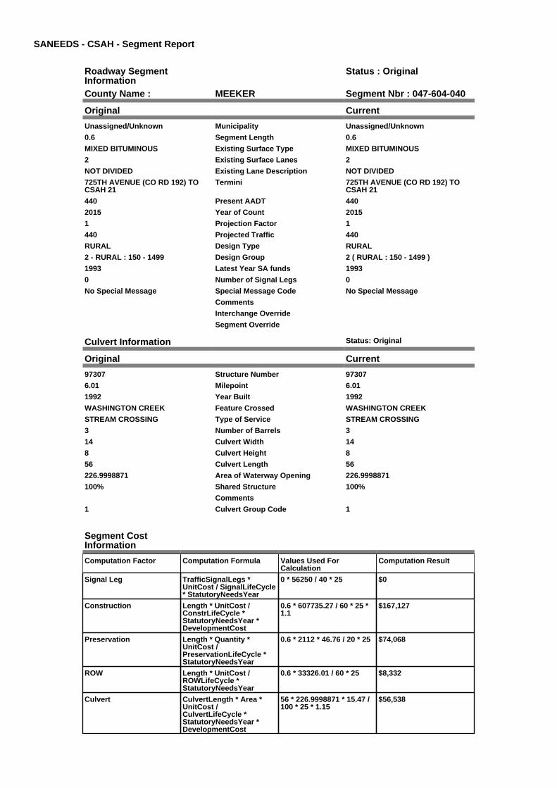
County Name : MEEKER Segment Nbr : 047-604-040
Original Current
Unassigned/Unknown Municipality Unassigned/Unknown
0.6 Segment Length 0.6
MIXED BITUMINOUS Existing Surface Type MIXED BITUMINOUS
2 Existing Surface Lanes 2
NOT DIVIDED Existing Lane Description NOT DIVIDED
725TH AVENUE (CO RD 192) TOCSAH 21
Termini 725TH AVENUE (CO RD 192) TOCSAH 21
440 Present AADT 440
2015 Year of Count 2015
1 Projection Factor 1
440 Projected Traffic 440
RURAL Design Type RURAL
2 - RURAL : 150 - 1499 Design Group 2 ( RURAL : 150 - 1499 )
1993 Latest Year SA funds 1993
0 Number of Signal Legs 0
No Special Message Special Message Code No Special Message
Comments
Interchange Override
Segment Override
Culvert Information Status: Original
Original Current
97307 Structure Number 97307
6.01 Milepoint 6.01
1992 Year Built 1992
WASHINGTON CREEK Feature Crossed WASHINGTON CREEK
STREAM CROSSING Type of Service STREAM CROSSING
3 Number of Barrels 3
14 Culvert Width 14
8 Culvert Height 8
56 Culvert Length 56
226.9998871 Area of Waterway Opening 226.9998871
100% Shared Structure 100%
Comments
1 Culvert Group Code 1
Segment CostInformation
Computation Factor Computation Formula Values Used ForCalculation
Computation Result
Signal Leg TrafficSignalLegs *UnitCost / SignalLifeCycle* StatutoryNeedsYear
0 * 56250 / 40 * 25 $0
Construction Length * UnitCost /ConstrLifeCycle *StatutoryNeedsYear *DevelopmentCost
0.6 * 607735.27 / 60 * 25 *1.1
$167,127
Preservation Length * Quantity *UnitCost /PreservationLifeCycle *StatutoryNeedsYear
0.6 * 2112 * 46.76 / 20 * 25 $74,068
ROW Length * UnitCost /ROWLifeCycle *StatutoryNeedsYear
0.6 * 33326.01 / 60 * 25 $8,332
Culvert CulvertLength * Area *UnitCost /CulvertLifeCycle *StatutoryNeedsYear *DevelopmentCost
56 * 226.9998871 * 15.47 /100 * 25 * 1.15
$56,538

Total Segment Cost Signal Leg + Construction+ Preservation + ROW +Culvert
$0 + $167,127 + $74,068 +$8,332 + $56,538
$306,065

SANEEDS - CSAH - Segment Report
Roadway SegmentInformation
Status : Original
County Name : MEEKER Segment Nbr : 047-605-005
Original Current
Unassigned/Unknown Municipality Unassigned/Unknown
1 Segment Length 1
MIXED BITUMINOUS Existing Surface Type MIXED BITUMINOUS
2 Existing Surface Lanes 2
NOT DIVIDED Existing Lane Description NOT DIVIDED
CSAH 18 TO CSAH 15 Termini CSAH 18 TO CSAH 15
152 Present AADT 152
2015 Year of Count 2015
1.9 Projection Factor 1.9
152 Projected Traffic 152
RURAL Design Type RURAL
2 - RURAL : 150 - 1499 Design Group 2 ( RURAL : 150 - 1499 )
2015 Latest Year SA funds 2015
0 Number of Signal Legs 0
No Special Message Special Message Code No Special Message
2015 SAP 047-605-005 PH2 PAVING2013 SAP 047-605-003 PH1 G&B
COMMISSIONER'S ORDER 91373(5/26/10)
Comments 2015 SAP 047-605-005 PH2 PAVING2013 SAP 047-605-003 PH1 G&B
COMMISSIONER'S ORDER 91373(5/26/10)
Interchange Override
Segment Override
Segment CostInformation
Computation Factor Computation Formula Values Used ForCalculation
Computation Result
Signal Leg TrafficSignalLegs *UnitCost / SignalLifeCycle* StatutoryNeedsYear
0 * 56250 / 40 * 25 $0
Construction Length * UnitCost /ConstrLifeCycle *StatutoryNeedsYear *DevelopmentCost
1 * 607735.27 / 60 * 25 * 1.1 $278,545
Preservation Length * Quantity *UnitCost /PreservationLifeCycle *StatutoryNeedsYear
1 * 2112 * 46.76 / 20 * 25 $123,446
ROW Length * UnitCost /ROWLifeCycle *StatutoryNeedsYear
1 * 33326.01 / 60 * 25 $13,886
Total Segment Cost Signal Leg + Construction+ Preservation + ROW
$0 + $278,545 + $123,446+ $13,886
$415,877

SANEEDS - CSAH - Segment Report
Roadway SegmentInformation
Status : Original
County Name : MEEKER Segment Nbr : 047-605-010
Original Current
Unassigned/Unknown Municipality Unassigned/Unknown
1.4 Segment Length 1.4
MIXED BITUMINOUS Existing Surface Type MIXED BITUMINOUS
2 Existing Surface Lanes 2
NOT DIVIDED Existing Lane Description NOT DIVIDED
CSAH 15 TO E CO LINE Termini CSAH 15 TO E CO LINE
156 Present AADT 156
2015 Year of Count 2015
1.3 Projection Factor 1.3
156 Projected Traffic 156
RURAL Design Type RURAL
2 - RURAL : 150 - 1499 Design Group 2 ( RURAL : 150 - 1499 )
2013 Latest Year SA funds 2013
0 Number of Signal Legs 0
No Special Message Special Message Code No Special Message
2013 SAP 047-605-004 M&OL Comments 2013 SAP 047-605-004 M&OL
Interchange Override
Segment Override
Segment CostInformation
Computation Factor Computation Formula Values Used ForCalculation
Computation Result
Signal Leg TrafficSignalLegs *UnitCost / SignalLifeCycle* StatutoryNeedsYear
0 * 56250 / 40 * 25 $0
Construction Length * UnitCost /ConstrLifeCycle *StatutoryNeedsYear *DevelopmentCost
1.4 * 607735.27 / 60 * 25 *1.1
$389,963
Preservation Length * Quantity *UnitCost /PreservationLifeCycle *StatutoryNeedsYear
1.4 * 2112 * 46.76 / 20 * 25 $172,825
ROW Length * UnitCost /ROWLifeCycle *StatutoryNeedsYear
1.4 * 33326.01 / 60 * 25 $19,440
Total Segment Cost Signal Leg + Construction+ Preservation + ROW
$0 + $389,963 + $172,825+ $19,440
$582,228

SANEEDS - CSAH - Segment Report
Roadway SegmentInformation
Status : Original
County Name : MEEKER Segment Nbr : 047-606-010
Original Current
DASSEL Municipality DASSEL
0.06 Segment Length 0.06
MIXED BITUMINOUS Existing Surface Type MIXED BITUMINOUS
2 Existing Surface Lanes 2
NOT DIVIDED Existing Lane Description NOT DIVIDED
JCT CSAH 4 AND SIMON AVE TOSIMON AVE AND 3RD ST
Termini JCT CSAH 4 AND SIMON AVE TOSIMON AVE AND 3RD ST
540 Present AADT 540
2015 Year of Count 2015
1 Projection Factor 1
540 Projected Traffic 540
URBAN Design Type URBAN
5 - URBAN : 0 - 9999 Design Group 5 ( URBAN : 0 - 9999 )
1999 Latest Year SA funds 1999
0 Number of Signal Legs 0
No Special Message Special Message Code No Special Message
Comments
Interchange Override
Segment Override
Segment CostInformation
Computation Factor Computation Formula Values Used ForCalculation
Computation Result
Signal Leg TrafficSignalLegs *UnitCost / SignalLifeCycle* StatutoryNeedsYear
0 * 56250 / 40 * 25 $0
Construction Length * UnitCost /ConstrLifeCycle *StatutoryNeedsYear *DevelopmentCost
0.06 * 1892111.74 / 60 * 25* 1.15
$54,398
Preservation Length * Quantity *UnitCost /PreservationLifeCycle *StatutoryNeedsYear
0.06 * 2904 * 46.76 / 15 * 25 $13,579
ROW Length * UnitCost /ROWLifeCycle *StatutoryNeedsYear
0.06 * 10842.12 / 60 * 25 $271
Total Segment Cost Signal Leg + Construction+ Preservation + ROW
$0 + $54,398 + $13,579 +$271
$68,248

SANEEDS - CSAH - Segment Report
Roadway SegmentInformation
Status : Original
County Name : MEEKER Segment Nbr : 047-606-011
Original Current
DASSEL Municipality DASSEL
0.22 Segment Length 0.22
MIXED BITUMINOUS Existing Surface Type MIXED BITUMINOUS
2 Existing Surface Lanes 2
NOT DIVIDED Existing Lane Description NOT DIVIDED
3RD ST & SIMON AVE TO 0.09 MI NOF S LIMS
Termini 3RD ST & SIMON AVE TO 0.09 MI NOF S LIMS
830 Present AADT 830
2015 Year of Count 2015
1 Projection Factor 1
830 Projected Traffic 830
URBAN Design Type URBAN
5 - URBAN : 0 - 9999 Design Group 5 ( URBAN : 0 - 9999 )
1999 Latest Year SA funds 1999
0 Number of Signal Legs 0
No Special Message Special Message Code No Special Message
Comments
Interchange Override
Segment Override
Segment CostInformation
Computation Factor Computation Formula Values Used ForCalculation
Computation Result
Signal Leg TrafficSignalLegs *UnitCost / SignalLifeCycle* StatutoryNeedsYear
0 * 56250 / 40 * 25 $0
Construction Length * UnitCost /ConstrLifeCycle *StatutoryNeedsYear *DevelopmentCost
0.22 * 1892111.74 / 60 * 25* 1.15
$199,460
Preservation Length * Quantity *UnitCost /PreservationLifeCycle *StatutoryNeedsYear
0.22 * 2904 * 46.76 / 15 * 25 $49,790
ROW Length * UnitCost /ROWLifeCycle *StatutoryNeedsYear
0.22 * 10842.12 / 60 * 25 $994
Total Segment Cost Signal Leg + Construction+ Preservation + ROW
$0 + $199,460 + $49,790 +$994
$250,244

SANEEDS - CSAH - Segment Report
Roadway SegmentInformation
Status : Original
County Name : MEEKER Segment Nbr : 047-606-013
Original Current
DASSEL Municipality DASSEL
0.09 Segment Length 0.09
MIXED BITUMINOUS Existing Surface Type MIXED BITUMINOUS
2 Existing Surface Lanes 2
NOT DIVIDED Existing Lane Description NOT DIVIDED
0.09 MI N TO S LIMS DASSEL Termini 0.09 MI N TO S LIMS DASSEL
830 Present AADT 830
2015 Year of Count 2015
1 Projection Factor 1
830 Projected Traffic 830
URBAN Design Type URBAN
5 - URBAN : 0 - 9999 Design Group 5 ( URBAN : 0 - 9999 )
1999 Latest Year SA funds 1999
0 Number of Signal Legs 0
No Special Message Special Message Code No Special Message
Comments
Interchange Override
Segment Override
Segment CostInformation
Computation Factor Computation Formula Values Used ForCalculation
Computation Result
Signal Leg TrafficSignalLegs *UnitCost / SignalLifeCycle* StatutoryNeedsYear
0 * 56250 / 40 * 25 $0
Construction Length * UnitCost /ConstrLifeCycle *StatutoryNeedsYear *DevelopmentCost
0.09 * 1892111.74 / 60 * 25* 1.15
$81,597
Preservation Length * Quantity *UnitCost /PreservationLifeCycle *StatutoryNeedsYear
0.09 * 2904 * 46.76 / 15 * 25 $20,369
ROW Length * UnitCost /ROWLifeCycle *StatutoryNeedsYear
0.09 * 10842.12 / 60 * 25 $407
Total Segment Cost Signal Leg + Construction+ Preservation + ROW
$0 + $81,597 + $20,369 +$407
$102,373

SANEEDS - CSAH - Segment Report
Roadway SegmentInformation
Status : Original
County Name : MEEKER Segment Nbr : 047-606-015
Original Current
DASSEL Municipality DASSEL
0.53 Segment Length 0.53
MIXED BITUMINOUS Existing Surface Type MIXED BITUMINOUS
2 Existing Surface Lanes 2
NOT DIVIDED Existing Lane Description NOT DIVIDED
ON SOUTH LIMS DASSEL Termini ON SOUTH LIMS DASSEL
830 Present AADT 830
2015 Year of Count 2015
1 Projection Factor 1
830 Projected Traffic 830
RURAL Design Type RURAL
2 - RURAL : 150 - 1499 Design Group 2 ( RURAL : 150 - 1499 )
1999 Latest Year SA funds 1999
0 Number of Signal Legs 0
No Special Message Special Message Code No Special Message
Comments
Interchange Override
Segment Override
Segment CostInformation
Computation Factor Computation Formula Values Used ForCalculation
Computation Result
Signal Leg TrafficSignalLegs *UnitCost / SignalLifeCycle* StatutoryNeedsYear
0 * 56250 / 40 * 25 $0
Construction Length * UnitCost /ConstrLifeCycle *StatutoryNeedsYear *DevelopmentCost
0.53 * 607735.27 / 60 * 25 *1.1
$147,629
Preservation Length * Quantity *UnitCost /PreservationLifeCycle *StatutoryNeedsYear
0.53 * 2112 * 46.76 / 20 * 25 $65,427
ROW Length * UnitCost /ROWLifeCycle *StatutoryNeedsYear
0.53 * 33326.01 / 60 * 25 $7,359
Total Segment Cost Signal Leg + Construction+ Preservation + ROW
$0 + $147,629 + $65,427 +$7,359
$220,415

SANEEDS - CSAH - Segment Report
Roadway SegmentInformation
Status : Original
County Name : MEEKER Segment Nbr : 047-606-017
Original Current
Unassigned/Unknown Municipality Unassigned/Unknown
0.5 Segment Length 0.5
MIXED BITUMINOUS Existing Surface Type MIXED BITUMINOUS
2 Existing Surface Lanes 2
NOT DIVIDED Existing Lane Description NOT DIVIDED
S LIM DASSEL TO 0.50 MI S (1MILE W OF CSAH 15)
Termini S LIM DASSEL TO 0.50 MI S (1MILE W OF CSAH 15)
820 Present AADT 820
2015 Year of Count 2015
1 Projection Factor 1
820 Projected Traffic 820
RURAL Design Type RURAL
2 - RURAL : 150 - 1499 Design Group 2 ( RURAL : 150 - 1499 )
2000 Latest Year SA funds 2000
0 Number of Signal Legs 0
No Special Message Special Message Code No Special Message
Comments
Interchange Override
Segment Override
Segment CostInformation
Computation Factor Computation Formula Values Used ForCalculation
Computation Result
Signal Leg TrafficSignalLegs *UnitCost / SignalLifeCycle* StatutoryNeedsYear
0 * 56250 / 40 * 25 $0
Construction Length * UnitCost /ConstrLifeCycle *StatutoryNeedsYear *DevelopmentCost
0.5 * 607735.27 / 60 * 25 *1.1
$139,273
Preservation Length * Quantity *UnitCost /PreservationLifeCycle *StatutoryNeedsYear
0.5 * 2112 * 46.76 / 20 * 25 $61,723
ROW Length * UnitCost /ROWLifeCycle *StatutoryNeedsYear
0.5 * 33326.01 / 60 * 25 $6,943
Total Segment Cost Signal Leg + Construction+ Preservation + ROW
$0 + $139,273 + $61,723 +$6,943
$207,939

SANEEDS - CSAH - Segment Report
Roadway SegmentInformation
Status : Original
County Name : MEEKER Segment Nbr : 047-606-020
Original Current
Unassigned/Unknown Municipality Unassigned/Unknown
1 Segment Length 1
MIXED BITUMINOUS Existing Surface Type MIXED BITUMINOUS
2 Existing Surface Lanes 2
NOT DIVIDED Existing Lane Description NOT DIVIDED
730TH AVENUE (1.0 MI W) TOCSAH 15
Termini 730TH AVENUE (1.0 MI W) TOCSAH 15
820 Present AADT 820
2015 Year of Count 2015
1 Projection Factor 1
820 Projected Traffic 820
RURAL Design Type RURAL
2 - RURAL : 150 - 1499 Design Group 2 ( RURAL : 150 - 1499 )
2000 Latest Year SA funds 2000
0 Number of Signal Legs 0
No Special Message Special Message Code No Special Message
Comments
Interchange Override
Segment Override
Segment CostInformation
Computation Factor Computation Formula Values Used ForCalculation
Computation Result
Signal Leg TrafficSignalLegs *UnitCost / SignalLifeCycle* StatutoryNeedsYear
0 * 56250 / 40 * 25 $0
Construction Length * UnitCost /ConstrLifeCycle *StatutoryNeedsYear *DevelopmentCost
1 * 607735.27 / 60 * 25 * 1.1 $278,545
Preservation Length * Quantity *UnitCost /PreservationLifeCycle *StatutoryNeedsYear
1 * 2112 * 46.76 / 20 * 25 $123,446
ROW Length * UnitCost /ROWLifeCycle *StatutoryNeedsYear
1 * 33326.01 / 60 * 25 $13,886
Total Segment Cost Signal Leg + Construction+ Preservation + ROW
$0 + $278,545 + $123,446+ $13,886
$415,877

SANEEDS - CSAH - Segment Report
Roadway SegmentInformation
Status : Original
County Name : MEEKER Segment Nbr : 047-606-030
Original Current
Unassigned/Unknown Municipality Unassigned/Unknown
1 Segment Length 1
MIXED BITUMINOUS Existing Surface Type MIXED BITUMINOUS
2 Existing Surface Lanes 2
NOT DIVIDED Existing Lane Description NOT DIVIDED
CSAH 15 TO E CO LINE Termini CSAH 15 TO E CO LINE
820 Present AADT 820
2015 Year of Count 2015
1 Projection Factor 1
820 Projected Traffic 820
RURAL Design Type RURAL
2 - RURAL : 150 - 1499 Design Group 2 ( RURAL : 150 - 1499 )
1965 Latest Year SA funds 1965
0 Number of Signal Legs 0
No Special Message Special Message Code No Special Message
Comments
Interchange Override
Segment Override
Culvert Information Status: Original
Original Current
90998 Structure Number 90998
3.335 Milepoint 3.335
1965 Year Built 1965
COLLINGWOOD CREEK Feature Crossed COLLINGWOOD CREEK
Type of Service
1 Number of Barrels 1
12 Culvert Width 12
8 Culvert Height 8
78 Culvert Length 78
85.00036552 Area of Waterway Opening 85.00036552
100% Shared Structure 100%
Comments
1 Culvert Group Code 1
Segment CostInformation
Computation Factor Computation Formula Values Used ForCalculation
Computation Result
Signal Leg TrafficSignalLegs *UnitCost / SignalLifeCycle* StatutoryNeedsYear
0 * 56250 / 40 * 25 $0
Construction Length * UnitCost /ConstrLifeCycle *StatutoryNeedsYear *DevelopmentCost
1 * 607735.27 / 60 * 25 * 1.1 $278,545
Preservation Length * Quantity *UnitCost /PreservationLifeCycle *StatutoryNeedsYear
1 * 2112 * 46.76 / 20 * 25 $123,446
ROW Length * UnitCost /ROWLifeCycle *StatutoryNeedsYear
1 * 33326.01 / 60 * 25 $13,886
Culvert CulvertLength * Area *UnitCost /CulvertLifeCycle *StatutoryNeedsYear *DevelopmentCost
78 * 85.00036552 * 15.47 /100 * 25 * 1.15
$29,488
Total Segment Cost Signal Leg + Construction+ Preservation + ROW +Culvert
$0 + $278,545 + $123,446+ $13,886 + $29,488
$445,365

SANEEDS - CSAH - Segment Report
Roadway SegmentInformation
Status : Original
County Name : MEEKER Segment Nbr : 047-607-010
Original Current
Unassigned/Unknown Municipality Unassigned/Unknown
0.5 Segment Length 0.5
MIXED BITUMINOUS Existing Surface Type MIXED BITUMINOUS
2 Existing Surface Lanes 2
NOT DIVIDED Existing Lane Description NOT DIVIDED
CSAH 19 S AND ALONG E CO LINE Termini CSAH 19 S AND ALONG E CO LINE
375 Present AADT 375
2015 Year of Count 2015
1 Projection Factor 1
375 Projected Traffic 375
RURAL Design Type RURAL
2 - RURAL : 150 - 1499 Design Group 2 ( RURAL : 150 - 1499 )
1970 Latest Year SA funds 1970
0 Number of Signal Legs 0
No Special Message Special Message Code No Special Message
Comments
Interchange Override
Segment Override
Segment CostInformation
Computation Factor Computation Formula Values Used ForCalculation
Computation Result
Signal Leg TrafficSignalLegs *UnitCost / SignalLifeCycle* StatutoryNeedsYear
0 * 56250 / 40 * 25 $0
Construction Length * UnitCost /ConstrLifeCycle *StatutoryNeedsYear *DevelopmentCost
0.5 * 607735.27 / 60 * 25 *1.1
$139,273
Preservation Length * Quantity *UnitCost /PreservationLifeCycle *StatutoryNeedsYear
0.5 * 2112 * 46.76 / 20 * 25 $61,723
ROW Length * UnitCost /ROWLifeCycle *StatutoryNeedsYear
0.5 * 33326.01 / 60 * 25 $6,943
Total Segment Cost Signal Leg + Construction+ Preservation + ROW
$0 + $139,273 + $61,723 +$6,943
$207,939
SANEEDS - CSAH - Segment Report
Roadway SegmentInformation
Status : Original
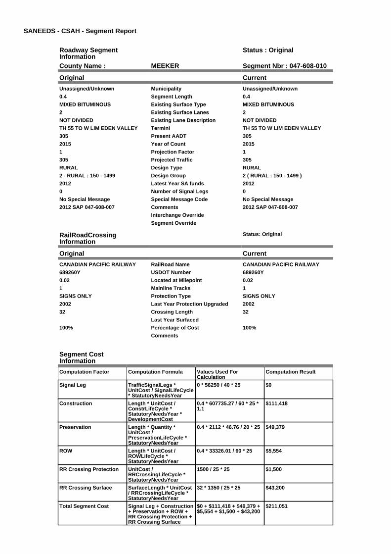
County Name : MEEKER Segment Nbr : 047-608-010
Original Current
Unassigned/Unknown Municipality Unassigned/Unknown
0.4 Segment Length 0.4
MIXED BITUMINOUS Existing Surface Type MIXED BITUMINOUS
2 Existing Surface Lanes 2
NOT DIVIDED Existing Lane Description NOT DIVIDED
TH 55 TO W LIM EDEN VALLEY Termini TH 55 TO W LIM EDEN VALLEY
305 Present AADT 305
2015 Year of Count 2015
1 Projection Factor 1
305 Projected Traffic 305
RURAL Design Type RURAL
2 - RURAL : 150 - 1499 Design Group 2 ( RURAL : 150 - 1499 )
2012 Latest Year SA funds 2012
0 Number of Signal Legs 0
No Special Message Special Message Code No Special Message
2012 SAP 047-608-007 Comments 2012 SAP 047-608-007
Interchange Override
Segment Override
RailRoadCrossingInformation
Status: Original
Original Current
CANADIAN PACIFIC RAILWAY RailRoad Name CANADIAN PACIFIC RAILWAY
689260Y USDOT Number 689260Y
0.02 Located at Milepoint 0.02
1 Mainline Tracks 1
SIGNS ONLY Protection Type SIGNS ONLY
2002 Last Year Protection Upgraded 2002
32 Crossing Length 32
Last Year Surfaced
100% Percentage of Cost 100%
Comments
Segment CostInformation
Computation Factor Computation Formula Values Used ForCalculation
Computation Result
Signal Leg TrafficSignalLegs *UnitCost / SignalLifeCycle* StatutoryNeedsYear
0 * 56250 / 40 * 25 $0
Construction Length * UnitCost /ConstrLifeCycle *StatutoryNeedsYear *DevelopmentCost
0.4 * 607735.27 / 60 * 25 *1.1
$111,418
Preservation Length * Quantity *UnitCost /PreservationLifeCycle *StatutoryNeedsYear
0.4 * 2112 * 46.76 / 20 * 25 $49,379
ROW Length * UnitCost /ROWLifeCycle *StatutoryNeedsYear
0.4 * 33326.01 / 60 * 25 $5,554
RR Crossing Protection UnitCost /RRCrossingLifeCycle *StatutoryNeedsYear
1500 / 25 * 25 $1,500
RR Crossing Surface SurfaceLength * UnitCost/ RRCrossingLifeCycle *StatutoryNeedsYear
32 * 1350 / 25 * 25 $43,200
Total Segment Cost Signal Leg + Construction+ Preservation + ROW +RR Crossing Protection +RR Crossing Surface
$0 + $111,418 + $49,379 +$5,554 + $1,500 + $43,200
$211,051

SANEEDS - CSAH - Segment Report
Roadway SegmentInformation
Status : Original
County Name : MEEKER Segment Nbr : 047-608-020
Original Current
EDEN VALLEY Municipality EDEN VALLEY
0.3 Segment Length 0.3
MIXED BITUMINOUS Existing Surface Type MIXED BITUMINOUS
2 Existing Surface Lanes 2
NOT DIVIDED Existing Lane Description NOT DIVIDED
W LIM EDEN VALLEY TO 0.20 M WOF TH 22
Termini W LIM EDEN VALLEY TO 0.20 M WOF TH 22
400 Present AADT 400
2015 Year of Count 2015
1 Projection Factor 1
400 Projected Traffic 400
RURAL Design Type RURAL
2 - RURAL : 150 - 1499 Design Group 2 ( RURAL : 150 - 1499 )
2012 Latest Year SA funds 2012
0 Number of Signal Legs 0
No Special Message Special Message Code No Special Message
2012 SAP 047-608-007 Comments 2012 SAP 047-608-007
Interchange Override
Segment Override
Segment CostInformation
Computation Factor Computation Formula Values Used ForCalculation
Computation Result
Signal Leg TrafficSignalLegs *UnitCost / SignalLifeCycle* StatutoryNeedsYear
0 * 56250 / 40 * 25 $0
Construction Length * UnitCost /ConstrLifeCycle *StatutoryNeedsYear *DevelopmentCost
0.3 * 607735.27 / 60 * 25 *1.1
$83,564
Preservation Length * Quantity *UnitCost /PreservationLifeCycle *StatutoryNeedsYear
0.3 * 2112 * 46.76 / 20 * 25 $37,034
ROW Length * UnitCost /ROWLifeCycle *StatutoryNeedsYear
0.3 * 33326.01 / 60 * 25 $4,166
Total Segment Cost Signal Leg + Construction+ Preservation + ROW
$0 + $83,564 + $37,034 +$4,166
$124,764

SANEEDS - CSAH - Segment Report
Roadway SegmentInformation
Status : Original
County Name : MEEKER Segment Nbr : 047-608-030
Original Current
EDEN VALLEY Municipality EDEN VALLEY
0.2 Segment Length 0.2
MIXED BITUMINOUS Existing Surface Type MIXED BITUMINOUS
2 Existing Surface Lanes 2
NOT DIVIDED Existing Lane Description NOT DIVIDED
0.20 M W OF TH22 TO TH22 Termini 0.20 M W OF TH22 TO TH22
680 Present AADT 680
2015 Year of Count 2015
1 Projection Factor 1
680 Projected Traffic 680
URBAN Design Type URBAN
5 - URBAN : 0 - 9999 Design Group 5 ( URBAN : 0 - 9999 )
1996 Latest Year SA funds 1996
0 Number of Signal Legs 0
No Special Message Special Message Code No Special Message
Comments
Interchange Override
Segment Override
Culvert Information Status: Original
Original Current
96245 Structure Number 96245
0.752 Milepoint 0.752
1996 Year Built 1996
EDEN BROOK Feature Crossed EDEN BROOK
STREAM CROSSING Type of Service STREAM CROSSING
2 Number of Barrels 2
8 Culvert Width 8
6 Culvert Height 6
54 Culvert Length 54
97.99992755 Area of Waterway Opening 97.99992755
100% Shared Structure 100%
Comments
1 Culvert Group Code 1
Segment CostInformation
Computation Factor Computation Formula Values Used ForCalculation
Computation Result
Signal Leg TrafficSignalLegs *UnitCost / SignalLifeCycle* StatutoryNeedsYear
0 * 56250 / 40 * 25 $0
Construction Length * UnitCost /ConstrLifeCycle *StatutoryNeedsYear *DevelopmentCost
0.2 * 1892111.74 / 60 * 25 *1.15
$181,327
Preservation Length * Quantity *UnitCost /PreservationLifeCycle *StatutoryNeedsYear
0.2 * 2904 * 46.76 / 15 * 25 $45,264
ROW Length * UnitCost /ROWLifeCycle *StatutoryNeedsYear
0.2 * 10842.12 / 60 * 25 $904
Culvert CulvertLength * Area *UnitCost /CulvertLifeCycle *StatutoryNeedsYear *DevelopmentCost
54 * 97.99992755 * 15.47 /100 * 25 * 1.15
$23,537
Total Segment Cost Signal Leg + Construction+ Preservation + ROW +Culvert
$0 + $181,327 + $45,264 +$904 + $23,537
$251,032

SANEEDS - CSAH - Segment Report
Roadway SegmentInformation
Status : Original
County Name : MEEKER Segment Nbr : 047-609-009
Original Current
Unassigned/Unknown Municipality Unassigned/Unknown
0.7 Segment Length 0.7
MIXED BITUMINOUS Existing Surface Type MIXED BITUMINOUS
2 Existing Surface Lanes 2
NOT DIVIDED Existing Lane Description NOT DIVIDED
S CO LINE TO 0.70 MI N Termini S CO LINE TO 0.70 MI N
155 Present AADT 155
2015 Year of Count 2015
1 Projection Factor 1
155 Projected Traffic 155
RURAL Design Type RURAL
2 - RURAL : 150 - 1499 Design Group 2 ( RURAL : 150 - 1499 )
1992 Latest Year SA funds 1992
0 Number of Signal Legs 0
No Special Message Special Message Code No Special Message
Comments
Interchange Override
Segment Override
Segment CostInformation
Computation Factor Computation Formula Values Used ForCalculation
Computation Result
Signal Leg TrafficSignalLegs *UnitCost / SignalLifeCycle* StatutoryNeedsYear
0 * 56250 / 40 * 25 $0
Construction Length * UnitCost /ConstrLifeCycle *StatutoryNeedsYear *DevelopmentCost
0.7 * 607735.27 / 60 * 25 *1.1
$194,982
Preservation Length * Quantity *UnitCost /PreservationLifeCycle *StatutoryNeedsYear
0.7 * 2112 * 46.76 / 20 * 25 $86,412
ROW Length * UnitCost /ROWLifeCycle *StatutoryNeedsYear
0.7 * 33326.01 / 60 * 25 $9,720
Total Segment Cost Signal Leg + Construction+ Preservation + ROW
$0 + $194,982 + $86,412 +$9,720
$291,114

SANEEDS - CSAH - Segment Report
Roadway SegmentInformation
Status : Original
County Name : MEEKER Segment Nbr : 047-609-010
Original Current
Unassigned/Unknown Municipality Unassigned/Unknown
0.1 Segment Length 0.1
MIXED BITUMINOUS Existing Surface Type MIXED BITUMINOUS
2 Existing Surface Lanes 2
NOT DIVIDED Existing Lane Description NOT DIVIDED
0.7 MI N TO 0.5 MI S OF CSAH 18 Termini 0.7 MI N TO 0.5 MI S OF CSAH 18
155 Present AADT 155
2015 Year of Count 2015
1 Projection Factor 1
155 Projected Traffic 155
URBAN Design Type URBAN
5 - URBAN : 0 - 9999 Design Group 5 ( URBAN : 0 - 9999 )
1992 Latest Year SA funds 1992
0 Number of Signal Legs 0
No Special Message Special Message Code No Special Message
Comments
Interchange Override
Segment Override
Segment CostInformation
Computation Factor Computation Formula Values Used ForCalculation
Computation Result
Signal Leg TrafficSignalLegs *UnitCost / SignalLifeCycle* StatutoryNeedsYear
0 * 56250 / 40 * 25 $0
Construction Length * UnitCost /ConstrLifeCycle *StatutoryNeedsYear *DevelopmentCost
0.1 * 1892111.74 / 60 * 25 *1.15
$90,664
Preservation Length * Quantity *UnitCost /PreservationLifeCycle *StatutoryNeedsYear
0.1 * 2904 * 46.76 / 15 * 25 $22,632
ROW Length * UnitCost /ROWLifeCycle *StatutoryNeedsYear
0.1 * 10842.12 / 60 * 25 $452
Total Segment Cost Signal Leg + Construction+ Preservation + ROW
$0 + $90,664 + $22,632 +$452
$113,748

SANEEDS - CSAH - Segment Report
Roadway SegmentInformation
Status : Original
County Name : MEEKER Segment Nbr : 047-609-011
Original Current
Unassigned/Unknown Municipality Unassigned/Unknown
0.5 Segment Length 0.5
MIXED BITUMINOUS Existing Surface Type MIXED BITUMINOUS
2 Existing Surface Lanes 2
NOT DIVIDED Existing Lane Description NOT DIVIDED
0.5 MI SO TO CSAH 18 Termini 0.5 MI SO TO CSAH 18
155 Present AADT 155
2015 Year of Count 2015
1 Projection Factor 1
155 Projected Traffic 155
RURAL Design Type RURAL
2 - RURAL : 150 - 1499 Design Group 2 ( RURAL : 150 - 1499 )
1992 Latest Year SA funds 1992
0 Number of Signal Legs 0
No Special Message Special Message Code No Special Message
Comments
Interchange Override
Segment Override
Segment CostInformation
Computation Factor Computation Formula Values Used ForCalculation
Computation Result
Signal Leg TrafficSignalLegs *UnitCost / SignalLifeCycle* StatutoryNeedsYear
0 * 56250 / 40 * 25 $0
Construction Length * UnitCost /ConstrLifeCycle *StatutoryNeedsYear *DevelopmentCost
0.5 * 607735.27 / 60 * 25 *1.1
$139,273
Preservation Length * Quantity *UnitCost /PreservationLifeCycle *StatutoryNeedsYear
0.5 * 2112 * 46.76 / 20 * 25 $61,723
ROW Length * UnitCost /ROWLifeCycle *StatutoryNeedsYear
0.5 * 33326.01 / 60 * 25 $6,943
Total Segment Cost Signal Leg + Construction+ Preservation + ROW
$0 + $139,273 + $61,723 +$6,943
$207,939

SANEEDS - CSAH - Segment Report
Roadway SegmentInformation
Status : Original
County Name : MEEKER Segment Nbr : 047-609-020
Original Current
Unassigned/Unknown Municipality Unassigned/Unknown
3.9 Segment Length 3.9
MIXED BITUMINOUS Existing Surface Type MIXED BITUMINOUS
2 Existing Surface Lanes 2
NOT DIVIDED Existing Lane Description NOT DIVIDED
CSAH 18 TO 208TH STREET Termini CSAH 18 TO 208TH STREET
710 Present AADT 710
2015 Year of Count 2015
1 Projection Factor 1
710 Projected Traffic 710
RURAL Design Type RURAL
2 - RURAL : 150 - 1499 Design Group 2 ( RURAL : 150 - 1499 )
2015 Latest Year SA funds 2015
0 Number of Signal Legs 0
No Special Message Special Message Code No Special Message
2015 SP 047-609-012 OL Comments 2015 SP 047-609-012 OL
Interchange Override
Segment Override
Segment CostInformation
Computation Factor Computation Formula Values Used ForCalculation
Computation Result
Signal Leg TrafficSignalLegs *UnitCost / SignalLifeCycle* StatutoryNeedsYear
0 * 56250 / 40 * 25 $0
Construction Length * UnitCost /ConstrLifeCycle *StatutoryNeedsYear *DevelopmentCost
3.9 * 607735.27 / 60 * 25 *1.1
$1,086,327
Preservation Length * Quantity *UnitCost /PreservationLifeCycle *StatutoryNeedsYear
3.9 * 2112 * 46.76 / 20 * 25 $481,441
ROW Length * UnitCost /ROWLifeCycle *StatutoryNeedsYear
3.9 * 33326.01 / 60 * 25 $54,155
Total Segment Cost Signal Leg + Construction+ Preservation + ROW
$0 + $1,086,327 + $481,441+ $54,155
$1,621,923

SANEEDS - CSAH - Segment Report
Roadway SegmentInformation
Status : Original
County Name : MEEKER Segment Nbr : 047-609-021
Original Current
Unassigned/Unknown Municipality Unassigned/Unknown
2.5 Segment Length 2.5
MIXED BITUMINOUS Existing Surface Type MIXED BITUMINOUS
2 Existing Surface Lanes 2
NOT DIVIDED Existing Lane Description NOT DIVIDED
208TH STREET TO 230TH STREET(CO RD 159)
Termini 208TH STREET TO 230TH STREET(CO RD 159)
710 Present AADT 710
2015 Year of Count 2015
1 Projection Factor 1
710 Projected Traffic 710
RURAL Design Type RURAL
2 - RURAL : 150 - 1499 Design Group 2 ( RURAL : 150 - 1499 )
2015 Latest Year SA funds 2015
0 Number of Signal Legs 0
No Special Message Special Message Code No Special Message
2015 SP 047-609-012 OL Comments 2015 SP 047-609-012 OL
Interchange Override
Segment Override
Segment CostInformation
Computation Factor Computation Formula Values Used ForCalculation
Computation Result
Signal Leg TrafficSignalLegs *UnitCost / SignalLifeCycle* StatutoryNeedsYear
0 * 56250 / 40 * 25 $0
Construction Length * UnitCost /ConstrLifeCycle *StatutoryNeedsYear *DevelopmentCost
2.5 * 607735.27 / 60 * 25 *1.1
$696,363
Preservation Length * Quantity *UnitCost /PreservationLifeCycle *StatutoryNeedsYear
2.5 * 2112 * 46.76 / 20 * 25 $308,616
ROW Length * UnitCost /ROWLifeCycle *StatutoryNeedsYear
2.5 * 33326.01 / 60 * 25 $34,715
Total Segment Cost Signal Leg + Construction+ Preservation + ROW
$0 + $696,363 + $308,616+ $34,715
$1,039,694
SANEEDS - CSAH - Segment Report
Roadway SegmentInformation
Status : Original
County Name : MEEKER Segment Nbr : 047-609-030
Original Current
Unassigned/Unknown Municipality Unassigned/Unknown
1.9 Segment Length 1.9
MIXED BITUMINOUS Existing Surface Type MIXED BITUMINOUS
2 Existing Surface Lanes 2
NOT DIVIDED Existing Lane Description NOT DIVIDED
230TH STREET (TWP RD 159) TOTH 12
Termini 230TH STREET (TWP RD 159) TOTH 12
710 Present AADT 710
2015 Year of Count 2015
1 Projection Factor 1
710 Projected Traffic 710
RURAL Design Type RURAL
2 - RURAL : 150 - 1499 Design Group 2 ( RURAL : 150 - 1499 )
2015 Latest Year SA funds 2015
0 Number of Signal Legs 0
No Special Message Special Message Code No Special Message
2015 SP 047-609-012 OL Comments 2015 SP 047-609-012 OL
Interchange Override
Segment Override
RailRoadCrossingInformation
Status: Original
Original Current
BURLINGTON NORTHERN SANTAFE RAILWAY
RailRoad Name BURLINGTON NORTHERN SANTAFE RAILWAY
067803U USDOT Number 067803U
1.88 Located at Milepoint 1.88
1 Mainline Tracks 1
SIGNALS ONLY Protection Type SIGNALS ONLY
1987 Last Year Protection Upgraded 1987
31 Crossing Length 31
Last Year Surfaced
100% Percentage of Cost 100%
Comments
Segment CostInformation
Computation Factor Computation Formula Values Used ForCalculation
Computation Result
Signal Leg TrafficSignalLegs *UnitCost / SignalLifeCycle* StatutoryNeedsYear
0 * 56250 / 40 * 25 $0
Construction Length * UnitCost /ConstrLifeCycle *StatutoryNeedsYear *DevelopmentCost
1.9 * 607735.27 / 60 * 25 *1.1
$529,236
Preservation Length * Quantity *UnitCost /PreservationLifeCycle *StatutoryNeedsYear
1.9 * 2112 * 46.76 / 20 * 25 $234,548
ROW Length * UnitCost /ROWLifeCycle *StatutoryNeedsYear
1.9 * 33326.01 / 60 * 25 $26,383
RR Crossing Protection UnitCost /RRCrossingLifeCycle *StatutoryNeedsYear
275000 / 25 * 25 $275,000
RR Crossing Surface SurfaceLength * UnitCost/ RRCrossingLifeCycle *StatutoryNeedsYear
31 * 1350 / 25 * 25 $41,850

Total Segment Cost Signal Leg + Construction+ Preservation + ROW +RR Crossing Protection +RR Crossing Surface
$0 + $529,236 + $234,548+ $26,383 + $275,000 +$41,850
$1,107,017

SANEEDS - CSAH - Segment Report
Roadway SegmentInformation
Status : Original
County Name : MEEKER Segment Nbr : 047-610-010
Original Current
Unassigned/Unknown Municipality Unassigned/Unknown
1 Segment Length 1
AGGREGATE SURF Existing Surface Type AGGREGATE SURF
2 Existing Surface Lanes 2
NOT DIVIDED Existing Lane Description NOT DIVIDED
SOUTH COUNTY LINE TO 110THSTREET (1.0 MI NO)
Termini SOUTH COUNTY LINE TO 110THSTREET (1.0 MI NO)
55 Present AADT 55
2015 Year of Count 2015
1 Projection Factor 1
55 Projected Traffic 55
RURAL Design Type RURAL
1 - RURAL : 0 - 149 Design Group 1 ( RURAL : 0 - 149 )
1992 Latest Year SA funds 1992
0 Number of Signal Legs 0
No Special Message Special Message Code No Special Message
Comments
Interchange Override
Segment Override
Segment CostInformation
Computation Factor Computation Formula Values Used ForCalculation
Computation Result
Construction Length * UnitCost /ConstrLifeCycle *StatutoryNeedsYear *DevelopmentCost
1 * 303867.64 / 60 * 25 * 1.1 $139,273
Preservation Length * Quantity *UnitCost /PreservationLifeCycle *StatutoryNeedsYear
1 * 546 * 10.3 / 2 * 25 $70,298
ROW Length * UnitCost /ROWLifeCycle *StatutoryNeedsYear
1 * 0 / 60 * 25 $0
Total Segment Cost Construction +Preservation + ROW
$139,273 + $70,298 + $0 $209,571

SANEEDS - CSAH - Segment Report
Roadway SegmentInformation
Status : Original
County Name : MEEKER Segment Nbr : 047-610-011
Original Current
Unassigned/Unknown Municipality Unassigned/Unknown
2 Segment Length 2
AGGREGATE SURF Existing Surface Type AGGREGATE SURF
2 Existing Surface Lanes 2
NOT DIVIDED Existing Lane Description NOT DIVIDED
110TH STREET (1.0 MI N OF S COLINE) TO TH 7
Termini 110TH STREET (1.0 MI N OF S COLINE) TO TH 7
55 Present AADT 55
2015 Year of Count 2015
1 Projection Factor 1
55 Projected Traffic 55
RURAL Design Type RURAL
1 - RURAL : 0 - 149 Design Group 1 ( RURAL : 0 - 149 )
2000 Latest Year SA funds 2000
0 Number of Signal Legs 0
No Special Message Special Message Code No Special Message
Comments
Interchange Override
Segment Override
Segment CostInformation
Computation Factor Computation Formula Values Used ForCalculation
Computation Result
Construction Length * UnitCost /ConstrLifeCycle *StatutoryNeedsYear *DevelopmentCost
2 * 303867.64 / 60 * 25 * 1.1 $278,545
Preservation Length * Quantity *UnitCost /PreservationLifeCycle *StatutoryNeedsYear
2 * 546 * 10.3 / 2 * 25 $140,595
ROW Length * UnitCost /ROWLifeCycle *StatutoryNeedsYear
2 * 0 / 60 * 25 $0
Total Segment Cost Construction +Preservation + ROW
$278,545 + $140,595 + $0 $419,140

SANEEDS - CSAH - Segment Report
Roadway SegmentInformation
Status : Original
County Name : MEEKER Segment Nbr : 047-610-020
Original Current
Unassigned/Unknown Municipality Unassigned/Unknown
4.3 Segment Length 4.3
AGGREGATE SURF Existing Surface Type AGGREGATE SURF
2 Existing Surface Lanes 2
NOT DIVIDED Existing Lane Description NOT DIVIDED
TH 7 TO CSAH 22 Termini TH 7 TO CSAH 22
60 Present AADT 60
2015 Year of Count 2015
1 Projection Factor 1
60 Projected Traffic 60
RURAL Design Type RURAL
1 - RURAL : 0 - 149 Design Group 1 ( RURAL : 0 - 149 )
1992 Latest Year SA funds 1992
0 Number of Signal Legs 0
No Special Message Special Message Code No Special Message
Comments
Interchange Override
Segment Override
Bridge Information Status: Original
Original Current
47522 Structure Number 47522
4.6 Milepoint 4.6
1980 Year Built 1980
S FK CROW RIVER Feature Crossed S FK CROW RIVER
Type of Service
Number of Spans
78 Bridge Length 78
34 Bridge Width 34
100% Shared Structure 100%
Comments
1 ( 0-149 ) Bridge Group Code 1 ( 0-149 )
Segment CostInformation
Computation Factor Computation Formula Values Used ForCalculation
Computation Result
Construction Length * UnitCost /ConstrLifeCycle *StatutoryNeedsYear *DevelopmentCost
4.3 * 303867.64 / 60 * 25 *1.1
$598,872
Preservation Length * Quantity *UnitCost /PreservationLifeCycle *StatutoryNeedsYear
4.3 * 546 * 10.3 / 2 * 25 $302,279
ROW Length * UnitCost /ROWLifeCycle *StatutoryNeedsYear
4.3 * 0 / 60 * 25 $0
Bridge BridgeLength *BridgeWidth * UnitCost /BridgeLifeCycle *StatutoryNeedsYear *DevelopmentCost
78 * 34 * 152 / 80 * 25 *1.15
$144,866
Total Segment Cost Construction +Preservation + ROW +Bridge
$598,872 + $302,279 + $0+ $144,866
$1,046,017

SANEEDS - CSAH - Segment Report
Roadway SegmentInformation
Status : Original
County Name : MEEKER Segment Nbr : 047-611-015
Original Current
GROVE CITY Municipality GROVE CITY
0.6 Segment Length 0.6
MIXED BITUMINOUS Existing Surface Type MIXED BITUMINOUS
2 Existing Surface Lanes 2
NOT DIVIDED Existing Lane Description NOT DIVIDED
JNC TH 4 TO 545 AVE Termini JNC TH 4 TO 545 AVE
1050 Present AADT 1050
2015 Year of Count 2015
1 Projection Factor 1
1050 Projected Traffic 1050
RURAL Design Type RURAL
2 - RURAL : 150 - 1499 Design Group 2 ( RURAL : 150 - 1499 )
1999 Latest Year SA funds 1999
0 Number of Signal Legs 0
No Special Message Special Message Code No Special Message
THIS SECTION REPLACESSEGMENTS 010 AND 019.
Comments THIS SECTION REPLACESSEGMENTS 010 AND 019.
Interchange Override
Segment Override
Segment CostInformation
Computation Factor Computation Formula Values Used ForCalculation
Computation Result
Signal Leg TrafficSignalLegs *UnitCost / SignalLifeCycle* StatutoryNeedsYear
0 * 56250 / 40 * 25 $0
Construction Length * UnitCost /ConstrLifeCycle *StatutoryNeedsYear *DevelopmentCost
0.6 * 607735.27 / 60 * 25 *1.1
$167,127
Preservation Length * Quantity *UnitCost /PreservationLifeCycle *StatutoryNeedsYear
0.6 * 2112 * 46.76 / 20 * 25 $74,068
ROW Length * UnitCost /ROWLifeCycle *StatutoryNeedsYear
0.6 * 33326.01 / 60 * 25 $8,332
Total Segment Cost Signal Leg + Construction+ Preservation + ROW
$0 + $167,127 + $74,068 +$8,332
$249,527

SANEEDS - CSAH - Segment Report
Roadway SegmentInformation
Status : Original
County Name : MEEKER Segment Nbr : 047-611-020
Original Current
Unassigned/Unknown Municipality Unassigned/Unknown
1 Segment Length 1
MIXED BITUMINOUS Existing Surface Type MIXED BITUMINOUS
2 Existing Surface Lanes 2
NOT DIVIDED Existing Lane Description NOT DIVIDED
270TH STREET (545 AVE) TOCSAH 32
Termini 270TH STREET (545 AVE) TOCSAH 32
1050 Present AADT 1050
2015 Year of Count 2015
1 Projection Factor 1
1050 Projected Traffic 1050
RURAL Design Type RURAL
2 - RURAL : 150 - 1499 Design Group 2 ( RURAL : 150 - 1499 )
2015 Latest Year SA funds 2015
0 Number of Signal Legs 0
No Special Message Special Message Code No Special Message
2015 SAP 047-611-028 OL Comments 2015 SAP 047-611-028 OL
Interchange Override
Segment Override
Segment CostInformation
Computation Factor Computation Formula Values Used ForCalculation
Computation Result
Signal Leg TrafficSignalLegs *UnitCost / SignalLifeCycle* StatutoryNeedsYear
0 * 56250 / 40 * 25 $0
Construction Length * UnitCost /ConstrLifeCycle *StatutoryNeedsYear *DevelopmentCost
1 * 607735.27 / 60 * 25 * 1.1 $278,545
Preservation Length * Quantity *UnitCost /PreservationLifeCycle *StatutoryNeedsYear
1 * 2112 * 46.76 / 20 * 25 $123,446
ROW Length * UnitCost /ROWLifeCycle *StatutoryNeedsYear
1 * 33326.01 / 60 * 25 $13,886
Total Segment Cost Signal Leg + Construction+ Preservation + ROW
$0 + $278,545 + $123,446+ $13,886
$415,877

SANEEDS - CSAH - Segment Report
Roadway SegmentInformation
Status : Original
County Name : MEEKER Segment Nbr : 047-611-021
Original Current
Unassigned/Unknown Municipality Unassigned/Unknown
1 Segment Length 1
MIXED BITUMINOUS Existing Surface Type MIXED BITUMINOUS
2 Existing Surface Lanes 2
NOT DIVIDED Existing Lane Description NOT DIVIDED
CSAH 32 TO 1.00 MI E Termini CSAH 32 TO 1.00 MI E
1050 Present AADT 1050
2015 Year of Count 2015
1 Projection Factor 1
1050 Projected Traffic 1050
RURAL Design Type RURAL
2 - RURAL : 150 - 1499 Design Group 2 ( RURAL : 150 - 1499 )
2015 Latest Year SA funds 2015
0 Number of Signal Legs 0
No Special Message Special Message Code No Special Message
2015 SAP 047-611-028 OL Comments 2015 SAP 047-611-028 OL
Interchange Override
Segment Override
Segment CostInformation
Computation Factor Computation Formula Values Used ForCalculation
Computation Result
Signal Leg TrafficSignalLegs *UnitCost / SignalLifeCycle* StatutoryNeedsYear
0 * 56250 / 40 * 25 $0
Construction Length * UnitCost /ConstrLifeCycle *StatutoryNeedsYear *DevelopmentCost
1 * 607735.27 / 60 * 25 * 1.1 $278,545
Preservation Length * Quantity *UnitCost /PreservationLifeCycle *StatutoryNeedsYear
1 * 2112 * 46.76 / 20 * 25 $123,446
ROW Length * UnitCost /ROWLifeCycle *StatutoryNeedsYear
1 * 33326.01 / 60 * 25 $13,886
Total Segment Cost Signal Leg + Construction+ Preservation + ROW
$0 + $278,545 + $123,446+ $13,886
$415,877

SANEEDS - CSAH - Segment Report
Roadway SegmentInformation
Status : Original
County Name : MEEKER Segment Nbr : 047-611-022
Original Current
Unassigned/Unknown Municipality Unassigned/Unknown
2.1 Segment Length 2.1
MIXED BITUMINOUS Existing Surface Type MIXED BITUMINOUS
2 Existing Surface Lanes 2
NOT DIVIDED Existing Lane Description NOT DIVIDED
1.00 MI E CSAH 32 TO 0.4 MI W OFCSAH 31
Termini 1.00 MI E CSAH 32 TO 0.4 MI W OFCSAH 31
1050 Present AADT 1050
2015 Year of Count 2015
1 Projection Factor 1
1050 Projected Traffic 1050
RURAL Design Type RURAL
2 - RURAL : 150 - 1499 Design Group 2 ( RURAL : 150 - 1499 )
2015 Latest Year SA funds 2015
0 Number of Signal Legs 0
No Special Message Special Message Code No Special Message
2015 SAP 047-611-028 OL Comments 2015 SAP 047-611-028 OL
Interchange Override
Segment Override
Segment CostInformation
Computation Factor Computation Formula Values Used ForCalculation
Computation Result
Signal Leg TrafficSignalLegs *UnitCost / SignalLifeCycle* StatutoryNeedsYear
0 * 56250 / 40 * 25 $0
Construction Length * UnitCost /ConstrLifeCycle *StatutoryNeedsYear *DevelopmentCost
2.1 * 607735.27 / 60 * 25 *1.1
$584,945
Preservation Length * Quantity *UnitCost /PreservationLifeCycle *StatutoryNeedsYear
2.1 * 2112 * 46.76 / 20 * 25 $259,237
ROW Length * UnitCost /ROWLifeCycle *StatutoryNeedsYear
2.1 * 33326.01 / 60 * 25 $29,160
Total Segment Cost Signal Leg + Construction+ Preservation + ROW
$0 + $584,945 + $259,237+ $29,160
$873,342

SANEEDS - CSAH - Segment Report
Roadway SegmentInformation
Status : Original
County Name : MEEKER Segment Nbr : 047-611-023
Original Current
Unassigned/Unknown Municipality Unassigned/Unknown
0.4 Segment Length 0.4
MIXED BITUMINOUS Existing Surface Type MIXED BITUMINOUS
2 Existing Surface Lanes 2
NOT DIVIDED Existing Lane Description NOT DIVIDED
0.4 MI W TO CSAH 31 Termini 0.4 MI W TO CSAH 31
1050 Present AADT 1050
2015 Year of Count 2015
1 Projection Factor 1
1050 Projected Traffic 1050
RURAL Design Type RURAL
2 - RURAL : 150 - 1499 Design Group 2 ( RURAL : 150 - 1499 )
2015 Latest Year SA funds 2015
0 Number of Signal Legs 0
No Special Message Special Message Code No Special Message
2015 SAP 047-611-028 OL Comments 2015 SAP 047-611-028 OL
Interchange Override
Segment Override
RailRoadCrossingInformation
Status: Original
Original Current
BURLINGTON NORTHERN SANTAFE RAILWAY
RailRoad Name BURLINGTON NORTHERN SANTAFE RAILWAY
067815N USDOT Number 067815N
0.3 Located at Milepoint 0.3
1 Mainline Tracks 1
SIGNALS & GATES Protection Type SIGNALS & GATES
1981 Last Year Protection Upgraded 1981
152 Crossing Length 152
Last Year Surfaced
100% Percentage of Cost 100%
Comments
Segment CostInformation
Computation Factor Computation Formula Values Used ForCalculation
Computation Result
Signal Leg TrafficSignalLegs *UnitCost / SignalLifeCycle* StatutoryNeedsYear
0 * 56250 / 40 * 25 $0
Construction Length * UnitCost /ConstrLifeCycle *StatutoryNeedsYear *DevelopmentCost
0.4 * 607735.27 / 60 * 25 *1.1
$111,418
Preservation Length * Quantity *UnitCost /PreservationLifeCycle *StatutoryNeedsYear
0.4 * 2112 * 46.76 / 20 * 25 $49,379
ROW Length * UnitCost /ROWLifeCycle *StatutoryNeedsYear
0.4 * 33326.01 / 60 * 25 $5,554
RR Crossing Protection UnitCost /RRCrossingLifeCycle *StatutoryNeedsYear
325000 / 25 * 25 $325,000
RR Crossing Surface SurfaceLength * UnitCost/ RRCrossingLifeCycle *StatutoryNeedsYear
152 * 1350 / 25 * 25 $205,200
Total Segment Cost Signal Leg + Construction+ Preservation + ROW +RR Crossing Protection +RR Crossing Surface
$0 + $111,418 + $49,379 +$5,554 + $325,000 +$205,200
$696,551

SANEEDS - CSAH - Segment Report
Roadway SegmentInformation
Status : Original
County Name : MEEKER Segment Nbr : 047-611-024
Original Current
Unassigned/Unknown Municipality Unassigned/Unknown
2 Segment Length 2
MIXED BITUMINOUS Existing Surface Type MIXED BITUMINOUS
2 Existing Surface Lanes 2
NOT DIVIDED Existing Lane Description NOT DIVIDED
CSAH 31 TO 11TH STREET (N LIMSLITCHFIELD)
Termini CSAH 31 TO 11TH STREET (N LIMSLITCHFIELD)
1450 Present AADT 1450
2015 Year of Count 2015
1 Projection Factor 1
1450 Projected Traffic 1450
RURAL Design Type RURAL
2 - RURAL : 150 - 1499 Design Group 2 ( RURAL : 150 - 1499 )
2015 Latest Year SA funds 2015
0 Number of Signal Legs 0
No Special Message Special Message Code No Special Message
2015 SAP 047-611-028 OL Comments 2015 SAP 047-611-028 OL
Interchange Override
Segment Override
Segment CostInformation
Computation Factor Computation Formula Values Used ForCalculation
Computation Result
Signal Leg TrafficSignalLegs *UnitCost / SignalLifeCycle* StatutoryNeedsYear
0 * 56250 / 40 * 25 $0
Construction Length * UnitCost /ConstrLifeCycle *StatutoryNeedsYear *DevelopmentCost
2 * 607735.27 / 60 * 25 * 1.1 $557,091
Preservation Length * Quantity *UnitCost /PreservationLifeCycle *StatutoryNeedsYear
2 * 2112 * 46.76 / 20 * 25 $246,893
ROW Length * UnitCost /ROWLifeCycle *StatutoryNeedsYear
2 * 33326.01 / 60 * 25 $27,772
Total Segment Cost Signal Leg + Construction+ Preservation + ROW
$0 + $557,091 + $246,893+ $27,772
$831,756

SANEEDS - CSAH - Segment Report
Roadway SegmentInformation
Status : Original
County Name : MEEKER Segment Nbr : 047-611-025
Original Current
LITCHFIELD Municipality LITCHFIELD
0.5 Segment Length 0.5
MIXED BITUMINOUS Existing Surface Type MIXED BITUMINOUS
2 Existing Surface Lanes 2
NOT DIVIDED Existing Lane Description NOT DIVIDED
11TH STREET (N LIMSLITCHFIELD) TO CSAH 1
Termini 11TH STREET (N LIMSLITCHFIELD) TO CSAH 1
1450 Present AADT 1450
2015 Year of Count 2015
1 Projection Factor 1
1450 Projected Traffic 1450
RURAL Design Type RURAL
2 - RURAL : 150 - 1499 Design Group 2 ( RURAL : 150 - 1499 )
2015 Latest Year SA funds 2015
0 Number of Signal Legs 0
No Special Message Special Message Code No Special Message
2015 SAP 047-611-028 OL Comments 2015 SAP 047-611-028 OL
Interchange Override
Segment Override
Segment CostInformation
Computation Factor Computation Formula Values Used ForCalculation
Computation Result
Signal Leg TrafficSignalLegs *UnitCost / SignalLifeCycle* StatutoryNeedsYear
0 * 56250 / 40 * 25 $0
Construction Length * UnitCost /ConstrLifeCycle *StatutoryNeedsYear *DevelopmentCost
0.5 * 607735.27 / 60 * 25 *1.1
$139,273
Preservation Length * Quantity *UnitCost /PreservationLifeCycle *StatutoryNeedsYear
0.5 * 2112 * 46.76 / 20 * 25 $61,723
ROW Length * UnitCost /ROWLifeCycle *StatutoryNeedsYear
0.5 * 33326.01 / 60 * 25 $6,943
Total Segment Cost Signal Leg + Construction+ Preservation + ROW
$0 + $139,273 + $61,723 +$6,943
$207,939

SANEEDS - CSAH - Segment Report
Roadway SegmentInformation
Status : Original
County Name : MEEKER Segment Nbr : 047-611-026
Original Current
LITCHFIELD Municipality LITCHFIELD
0.25 Segment Length 0.25
MIXED BITUMINOUS Existing Surface Type MIXED BITUMINOUS
2 Existing Surface Lanes 2
NOT DIVIDED Existing Lane Description NOT DIVIDED
CSAH 1 TO WILLMAR AVENUE Termini CSAH 1 TO WILLMAR AVENUE
880 Present AADT 880
2015 Year of Count 2015
1 Projection Factor 1
880 Projected Traffic 880
RURAL Design Type RURAL
2 - RURAL : 150 - 1499 Design Group 2 ( RURAL : 150 - 1499 )
2002 Latest Year SA funds 2002
0 Number of Signal Legs 0
No Special Message Special Message Code No Special Message
Comments
Interchange Override
Segment Override
Segment CostInformation
Computation Factor Computation Formula Values Used ForCalculation
Computation Result
Signal Leg TrafficSignalLegs *UnitCost / SignalLifeCycle* StatutoryNeedsYear
0 * 56250 / 40 * 25 $0
Construction Length * UnitCost /ConstrLifeCycle *StatutoryNeedsYear *DevelopmentCost
0.25 * 607735.27 / 60 * 25 *1.1
$69,636
Preservation Length * Quantity *UnitCost /PreservationLifeCycle *StatutoryNeedsYear
0.25 * 2112 * 46.76 / 20 * 25 $30,862
ROW Length * UnitCost /ROWLifeCycle *StatutoryNeedsYear
0.25 * 33326.01 / 60 * 25 $3,471
Total Segment Cost Signal Leg + Construction+ Preservation + ROW
$0 + $69,636 + $30,862 +$3,471
$103,969

SANEEDS - CSAH - Segment Report
Roadway SegmentInformation
Status : Original
County Name : MEEKER Segment Nbr : 047-611-030
Original Current
LITCHFIELD Municipality LITCHFIELD
0.19 Segment Length 0.19
MIXED BITUMINOUS Existing Surface Type MIXED BITUMINOUS
2 Existing Surface Lanes 2
NOT DIVIDED Existing Lane Description NOT DIVIDED
WILLMAR AVENUE TO AUSTIN AV Termini WILLMAR AVENUE TO AUSTIN AV
2150 Present AADT 2150
2015 Year of Count 2015
1 Projection Factor 1
2150 Projected Traffic 2150
URBAN Design Type URBAN
5 - URBAN : 0 - 9999 Design Group 5 ( URBAN : 0 - 9999 )
2002 Latest Year SA funds 2002
0 Number of Signal Legs 0
No Special Message Special Message Code No Special Message
Comments
Interchange Override
Segment Override
Culvert Information Status: Original
Original Current
92654 Structure Number 92654
7.89 Milepoint 7.89
1963 Year Built 1963
JEWETT CREEK (CD # 19) Feature Crossed JEWETT CREEK (CD # 19)
Type of Service
1 Number of Barrels 1
12 Culvert Width 12
8 Culvert Height 8
46 Culvert Length 46
65.99992924 Area of Waterway Opening 65.99992924
100% Shared Structure 100%
Comments
1 Culvert Group Code 1
Segment CostInformation
Computation Factor Computation Formula Values Used ForCalculation
Computation Result
Signal Leg TrafficSignalLegs *UnitCost / SignalLifeCycle* StatutoryNeedsYear
0 * 56250 / 40 * 25 $0
Construction Length * UnitCost /ConstrLifeCycle *StatutoryNeedsYear *DevelopmentCost
0.19 * 1892111.74 / 60 * 25* 1.15
$172,261
Preservation Length * Quantity *UnitCost /PreservationLifeCycle *StatutoryNeedsYear
0.19 * 2904 * 46.76 / 15 * 25 $43,000
ROW Length * UnitCost /ROWLifeCycle *StatutoryNeedsYear
0.19 * 10842.12 / 60 * 25 $858
Culvert CulvertLength * Area *UnitCost /CulvertLifeCycle *StatutoryNeedsYear *DevelopmentCost
46 * 65.99992924 * 15.47 /100 * 25 * 1.15
$13,503
Total Segment Cost Signal Leg + Construction+ Preservation + ROW +Culvert
$0 + $172,261 + $43,000 +$858 + $13,503
$229,622

SANEEDS - CSAH - Segment Report
Roadway SegmentInformation
Status : Original
County Name : MEEKER Segment Nbr : 047-611-031
Original Current
LITCHFIELD Municipality LITCHFIELD
0.28 Segment Length 0.28
MIXED BITUMINOUS Existing Surface Type MIXED BITUMINOUS
2 Existing Surface Lanes 2
NOT DIVIDED Existing Lane Description NOT DIVIDED
AUSTIN AV TO TH 12 Termini AUSTIN AV TO TH 12
2300 Present AADT 2300
2015 Year of Count 2015
1 Projection Factor 1
2300 Projected Traffic 2300
URBAN Design Type URBAN
5 - URBAN : 0 - 9999 Design Group 5 ( URBAN : 0 - 9999 )
2002 Latest Year SA funds 2002
0 Number of Signal Legs 0
No Special Message Special Message Code No Special Message
Comments
Interchange Override
Segment Override
Segment CostInformation
Computation Factor Computation Formula Values Used ForCalculation
Computation Result
Signal Leg TrafficSignalLegs *UnitCost / SignalLifeCycle* StatutoryNeedsYear
0 * 56250 / 40 * 25 $0
Construction Length * UnitCost /ConstrLifeCycle *StatutoryNeedsYear *DevelopmentCost
0.28 * 1892111.74 / 60 * 25* 1.15
$253,858
Preservation Length * Quantity *UnitCost /PreservationLifeCycle *StatutoryNeedsYear
0.28 * 2904 * 46.76 / 15 * 25 $63,369
ROW Length * UnitCost /ROWLifeCycle *StatutoryNeedsYear
0.28 * 10842.12 / 60 * 25 $1,265
Total Segment Cost Signal Leg + Construction+ Preservation + ROW
$0 + $253,858 + $63,369 +$1,265
$318,492

SANEEDS - CSAH - Segment Report
Roadway SegmentInformation
Status : Original
County Name : MEEKER Segment Nbr : 047-611-039
Original Current
LITCHFIELD Municipality LITCHFIELD
0.21 Segment Length 0.21
MIXED BITUMINOUS Existing Surface Type MIXED BITUMINOUS
2 Existing Surface Lanes 2
NOT DIVIDED Existing Lane Description NOT DIVIDED
TH 12 TO ARMSTRONG AV Termini TH 12 TO ARMSTRONG AV
2900 Present AADT 2900
2015 Year of Count 2015
1 Projection Factor 1
2900 Projected Traffic 2900
URBAN Design Type URBAN
5 - URBAN : 0 - 9999 Design Group 5 ( URBAN : 0 - 9999 )
1983 Latest Year SA funds 1983
0 Number of Signal Legs 0
No Special Message Special Message Code No Special Message
Comments
Interchange Override
Segment Override
Segment CostInformation
Computation Factor Computation Formula Values Used ForCalculation
Computation Result
Signal Leg TrafficSignalLegs *UnitCost / SignalLifeCycle* StatutoryNeedsYear
0 * 56250 / 40 * 25 $0
Construction Length * UnitCost /ConstrLifeCycle *StatutoryNeedsYear *DevelopmentCost
0.21 * 1892111.74 / 60 * 25* 1.15
$190,394
Preservation Length * Quantity *UnitCost /PreservationLifeCycle *StatutoryNeedsYear
0.21 * 2904 * 46.76 / 15 * 25 $47,527
ROW Length * UnitCost /ROWLifeCycle *StatutoryNeedsYear
0.21 * 10842.12 / 60 * 25 $949
Total Segment Cost Signal Leg + Construction+ Preservation + ROW
$0 + $190,394 + $47,527 +$949
$238,870

SANEEDS - CSAH - Segment Report
Roadway SegmentInformation
Status : Original
County Name : MEEKER Segment Nbr : 047-611-040
Original Current
LITCHFIELD Municipality LITCHFIELD
0.55 Segment Length 0.55
MIXED BITUMINOUS Existing Surface Type MIXED BITUMINOUS
2 Existing Surface Lanes 2
NOT DIVIDED Existing Lane Description NOT DIVIDED
ARMSTRONG TO GORMAN Termini ARMSTRONG TO GORMAN
3200 Present AADT 3200
2015 Year of Count 2015
1 Projection Factor 1
3200 Projected Traffic 3200
URBAN Design Type URBAN
5 - URBAN : 0 - 9999 Design Group 5 ( URBAN : 0 - 9999 )
1994 Latest Year SA funds 1994
0 Number of Signal Legs 0
No Special Message Special Message Code No Special Message
Comments
Interchange Override
Segment Override
Segment CostInformation
Computation Factor Computation Formula Values Used ForCalculation
Computation Result
Signal Leg TrafficSignalLegs *UnitCost / SignalLifeCycle* StatutoryNeedsYear
0 * 56250 / 40 * 25 $0
Construction Length * UnitCost /ConstrLifeCycle *StatutoryNeedsYear *DevelopmentCost
0.55 * 1892111.74 / 60 * 25* 1.15
$498,650
Preservation Length * Quantity *UnitCost /PreservationLifeCycle *StatutoryNeedsYear
0.55 * 2904 * 46.76 / 15 * 25 $124,475
ROW Length * UnitCost /ROWLifeCycle *StatutoryNeedsYear
0.55 * 10842.12 / 60 * 25 $2,485
Total Segment Cost Signal Leg + Construction+ Preservation + ROW
$0 + $498,650 + $124,475+ $2,485
$625,610

SANEEDS - CSAH - Segment Report
Roadway SegmentInformation
Status : Original
County Name : MEEKER Segment Nbr : 047-611-041
Original Current
LITCHFIELD Municipality LITCHFIELD
0.11 Segment Length 0.11
MIXED BITUMINOUS Existing Surface Type MIXED BITUMINOUS
2 Existing Surface Lanes 2
NOT DIVIDED Existing Lane Description NOT DIVIDED
GORMAN AV TO 0.11 MI E Termini GORMAN AV TO 0.11 MI E
1600 Present AADT 1600
2015 Year of Count 2015
1 Projection Factor 1
1600 Projected Traffic 1600
RURAL Design Type RURAL
3 - RURAL : 1500 - 6999 Design Group 3 ( RURAL : 1500 - 6999 )
1994 Latest Year SA funds 1994
0 Number of Signal Legs 0
No Special Message Special Message Code No Special Message
Comments
Interchange Override
Segment Override
Segment CostInformation
Computation Factor Computation Formula Values Used ForCalculation
Computation Result
Signal Leg TrafficSignalLegs *UnitCost / SignalLifeCycle* StatutoryNeedsYear
0 * 56250 / 40 * 25 $0
Construction Length * UnitCost /ConstrLifeCycle *StatutoryNeedsYear *DevelopmentCost
0.11 * 922582.78 / 60 * 25 *1.1
$46,514
Preservation Length * Quantity *UnitCost /PreservationLifeCycle *StatutoryNeedsYear
0.11 * 2376 * 46.76 / 20 * 25 $15,276
ROW Length * UnitCost /ROWLifeCycle *StatutoryNeedsYear
0.11 * 72889.99 / 60 * 25 $3,341
Total Segment Cost Signal Leg + Construction+ Preservation + ROW
$0 + $46,514 + $15,276 +$3,341
$65,131

SANEEDS - CSAH - Segment Report
Roadway SegmentInformation
Status : Original
County Name : MEEKER Segment Nbr : 047-611-050
Original Current
LITCHFIELD Municipality LITCHFIELD
0.25 Segment Length 0.25
MIXED BITUMINOUS Existing Surface Type MIXED BITUMINOUS
2 Existing Surface Lanes 2
NOT DIVIDED Existing Lane Description NOT DIVIDED
0.11 MI E GORMAN AV TO E LIMLITCHFIELD
Termini 0.11 MI E GORMAN AV TO E LIMLITCHFIELD
1600 Present AADT 1600
2015 Year of Count 2015
1 Projection Factor 1
1600 Projected Traffic 1600
RURAL Design Type RURAL
3 - RURAL : 1500 - 6999 Design Group 3 ( RURAL : 1500 - 6999 )
1994 Latest Year SA funds 1994
0 Number of Signal Legs 0
No Special Message Special Message Code No Special Message
Comments
Interchange Override
Segment Override
Segment CostInformation
Computation Factor Computation Formula Values Used ForCalculation
Computation Result
Signal Leg TrafficSignalLegs *UnitCost / SignalLifeCycle* StatutoryNeedsYear
0 * 56250 / 40 * 25 $0
Construction Length * UnitCost /ConstrLifeCycle *StatutoryNeedsYear *DevelopmentCost
0.25 * 922582.78 / 60 * 25 *1.1
$105,713
Preservation Length * Quantity *UnitCost /PreservationLifeCycle *StatutoryNeedsYear
0.25 * 2376 * 46.76 / 20 * 25 $34,719
ROW Length * UnitCost /ROWLifeCycle *StatutoryNeedsYear
0.25 * 72889.99 / 60 * 25 $7,593
Total Segment Cost Signal Leg + Construction+ Preservation + ROW
$0 + $105,713 + $34,719 +$7,593
$148,025

SANEEDS - CSAH - Segment Report
Roadway SegmentInformation
Status : Original
County Name : MEEKER Segment Nbr : 047-611-051
Original Current
Unassigned/Unknown Municipality Unassigned/Unknown
0.2 Segment Length 0.2
MIXED BITUMINOUS Existing Surface Type MIXED BITUMINOUS
2 Existing Surface Lanes 2
NOT DIVIDED Existing Lane Description NOT DIVIDED
E LIM LITCHFIELD TO CSAH 34 Termini E LIM LITCHFIELD TO CSAH 34
1600 Present AADT 1600
2015 Year of Count 2015
1 Projection Factor 1
1600 Projected Traffic 1600
RURAL Design Type RURAL
3 - RURAL : 1500 - 6999 Design Group 3 ( RURAL : 1500 - 6999 )
1994 Latest Year SA funds 1994
0 Number of Signal Legs 0
No Special Message Special Message Code No Special Message
Comments
Interchange Override
Segment Override
Segment CostInformation
Computation Factor Computation Formula Values Used ForCalculation
Computation Result
Signal Leg TrafficSignalLegs *UnitCost / SignalLifeCycle* StatutoryNeedsYear
0 * 56250 / 40 * 25 $0
Construction Length * UnitCost /ConstrLifeCycle *StatutoryNeedsYear *DevelopmentCost
0.2 * 922582.78 / 60 * 25 *1.1
$84,570
Preservation Length * Quantity *UnitCost /PreservationLifeCycle *StatutoryNeedsYear
0.2 * 2376 * 46.76 / 20 * 25 $27,775
ROW Length * UnitCost /ROWLifeCycle *StatutoryNeedsYear
0.2 * 72889.99 / 60 * 25 $6,074
Total Segment Cost Signal Leg + Construction+ Preservation + ROW
$0 + $84,570 + $27,775 +$6,074
$118,419

SANEEDS - CSAH - Segment Report
Roadway SegmentInformation
Status : Revised
County Name : MEEKER Segment Nbr : 047-611-060
Original Current
Unassigned/Unknown Municipality Unassigned/Unknown
5 Segment Length 5
MIXED BITUMINOUS Existing Surface Type MIXED BITUMINOUS
2 Existing Surface Lanes 2
NOT DIVIDED Existing Lane Description NOT DIVIDED
CSAH 34 TO CSAH 14 Termini CSAH 34 TO CSAH 14
460 Present AADT 460
2015 Year of Count 2015
1 Projection Factor 1
460 Projected Traffic 460
RURAL Design Type RURAL
2 - RURAL : 150 - 1499 Design Group 2 ( RURAL : 150 - 1499 )
2016 Latest Year SA funds 2016
0 Number of Signal Legs 0
No Special Message Special Message Code No Special Message
2016 SAP 047-611-029 M&OL Comments 2016 SAP 047-611-029 M&OL
Interchange Override
Segment Override
Segment CostInformation
Computation Factor Computation Formula Values Used ForCalculation
Computation Result
Signal Leg TrafficSignalLegs *UnitCost / SignalLifeCycle* StatutoryNeedsYear
0 * 56250 / 40 * 25 $0
Construction Length * UnitCost /ConstrLifeCycle *StatutoryNeedsYear *DevelopmentCost
5 * 607735.27 / 60 * 25 * 1.1 $1,392,727
Preservation Length * Quantity *UnitCost /PreservationLifeCycle *StatutoryNeedsYear
5 * 2112 * 46.76 / 20 * 25 $617,232
ROW Length * UnitCost /ROWLifeCycle *StatutoryNeedsYear
5 * 33326.01 / 60 * 25 $69,429
Total Segment Cost Signal Leg + Construction+ Preservation + ROW
$0 + $1,392,727 + $617,232+ $69,429
$2,079,388

SANEEDS - CSAH - Segment Report
Roadway SegmentInformation
Status : Original
County Name : MEEKER Segment Nbr : 047-612-010
Original Current
Unassigned/Unknown Municipality Unassigned/Unknown
3.9 Segment Length 3.9
MIXED BITUMINOUS Existing Surface Type MIXED BITUMINOUS
2 Existing Surface Lanes 2
NOT DIVIDED Existing Lane Description NOT DIVIDED
0.2 MI E CSAH 1 TO CSAH 26 Termini 0.2 MI E CSAH 1 TO CSAH 26
465 Present AADT 465
2015 Year of Count 2015
1 Projection Factor 1
465 Projected Traffic 465
RURAL Design Type RURAL
2 - RURAL : 150 - 1499 Design Group 2 ( RURAL : 150 - 1499 )
1994 Latest Year SA funds 1994
0 Number of Signal Legs 0
No Special Message Special Message Code No Special Message
Comments
Interchange Override
Segment Override
Segment CostInformation
Computation Factor Computation Formula Values Used ForCalculation
Computation Result
Signal Leg TrafficSignalLegs *UnitCost / SignalLifeCycle* StatutoryNeedsYear
0 * 56250 / 40 * 25 $0
Construction Length * UnitCost /ConstrLifeCycle *StatutoryNeedsYear *DevelopmentCost
3.9 * 607735.27 / 60 * 25 *1.1
$1,086,327
Preservation Length * Quantity *UnitCost /PreservationLifeCycle *StatutoryNeedsYear
3.9 * 2112 * 46.76 / 20 * 25 $481,441
ROW Length * UnitCost /ROWLifeCycle *StatutoryNeedsYear
3.9 * 33326.01 / 60 * 25 $54,155
Total Segment Cost Signal Leg + Construction+ Preservation + ROW
$0 + $1,086,327 + $481,441+ $54,155
$1,621,923

SANEEDS - CSAH - Segment Report
Roadway SegmentInformation
Status : Original
County Name : MEEKER Segment Nbr : 047-612-020
Original Current
Unassigned/Unknown Municipality Unassigned/Unknown
1 Segment Length 1
MIXED BITUMINOUS Existing Surface Type MIXED BITUMINOUS
2 Existing Surface Lanes 2
NOT DIVIDED Existing Lane Description NOT DIVIDED
CSAH 26 TO E CO LINE Termini CSAH 26 TO E CO LINE
730 Present AADT 730
2015 Year of Count 2015
1 Projection Factor 1
730 Projected Traffic 730
RURAL Design Type RURAL
2 - RURAL : 150 - 1499 Design Group 2 ( RURAL : 150 - 1499 )
1994 Latest Year SA funds 1994
0 Number of Signal Legs 0
No Special Message Special Message Code No Special Message
Comments
Interchange Override
Segment Override
Segment CostInformation
Computation Factor Computation Formula Values Used ForCalculation
Computation Result
Signal Leg TrafficSignalLegs *UnitCost / SignalLifeCycle* StatutoryNeedsYear
0 * 56250 / 40 * 25 $0
Construction Length * UnitCost /ConstrLifeCycle *StatutoryNeedsYear *DevelopmentCost
1 * 607735.27 / 60 * 25 * 1.1 $278,545
Preservation Length * Quantity *UnitCost /PreservationLifeCycle *StatutoryNeedsYear
1 * 2112 * 46.76 / 20 * 25 $123,446
ROW Length * UnitCost /ROWLifeCycle *StatutoryNeedsYear
1 * 33326.01 / 60 * 25 $13,886
Total Segment Cost Signal Leg + Construction+ Preservation + ROW
$0 + $278,545 + $123,446+ $13,886
$415,877

SANEEDS - CSAH - Segment Report
Roadway SegmentInformation
Status : Original
County Name : MEEKER Segment Nbr : 047-614-010
Original Current
Unassigned/Unknown Municipality Unassigned/Unknown
3.8 Segment Length 3.8
MIXED BITUMINOUS Existing Surface Type MIXED BITUMINOUS
2 Existing Surface Lanes 2
NOT DIVIDED Existing Lane Description NOT DIVIDED
SO CO LINE TO 195TH STREET(TWP RD 295)
Termini SO CO LINE TO 195TH STREET(TWP RD 295)
1700 Present AADT 1700
2015 Year of Count 2015
1 Projection Factor 1
1700 Projected Traffic 1700
RURAL Design Type RURAL
3 - RURAL : 1500 - 6999 Design Group 3 ( RURAL : 1500 - 6999 )
1993 Latest Year SA funds 1993
0 Number of Signal Legs 0
No Special Message Special Message Code No Special Message
Comments
Interchange Override
Segment Override
Segment CostInformation
Computation Factor Computation Formula Values Used ForCalculation
Computation Result
Signal Leg TrafficSignalLegs *UnitCost / SignalLifeCycle* StatutoryNeedsYear
0 * 56250 / 40 * 25 $0
Construction Length * UnitCost /ConstrLifeCycle *StatutoryNeedsYear *DevelopmentCost
3.8 * 922582.78 / 60 * 25 *1.1
$1,606,832
Preservation Length * Quantity *UnitCost /PreservationLifeCycle *StatutoryNeedsYear
3.8 * 2376 * 46.76 / 20 * 25 $527,733
ROW Length * UnitCost /ROWLifeCycle *StatutoryNeedsYear
3.8 * 72889.99 / 60 * 25 $115,409
Total Segment Cost Signal Leg + Construction+ Preservation + ROW
$0 + $1,606,832 + $527,733+ $115,409
$2,249,974

SANEEDS - CSAH - Segment Report
Roadway SegmentInformation
Status : Original
County Name : MEEKER Segment Nbr : 047-614-020
Original Current
Unassigned/Unknown Municipality Unassigned/Unknown
2.2 Segment Length 2.2
MIXED BITUMINOUS Existing Surface Type MIXED BITUMINOUS
2 Existing Surface Lanes 2
NOT DIVIDED Existing Lane Description NOT DIVIDED
195TH STREET TO CSAH 33 Termini 195TH STREET TO CSAH 33
1700 Present AADT 1700
2015 Year of Count 2015
1 Projection Factor 1
1700 Projected Traffic 1700
RURAL Design Type RURAL
3 - RURAL : 1500 - 6999 Design Group 3 ( RURAL : 1500 - 6999 )
1993 Latest Year SA funds 1993
0 Number of Signal Legs 0
No Special Message Special Message Code No Special Message
Comments
Interchange Override
Segment Override
Segment CostInformation
Computation Factor Computation Formula Values Used ForCalculation
Computation Result
Signal Leg TrafficSignalLegs *UnitCost / SignalLifeCycle* StatutoryNeedsYear
0 * 56250 / 40 * 25 $0
Construction Length * UnitCost /ConstrLifeCycle *StatutoryNeedsYear *DevelopmentCost
2.2 * 922582.78 / 60 * 25 *1.1
$930,271
Preservation Length * Quantity *UnitCost /PreservationLifeCycle *StatutoryNeedsYear
2.2 * 2376 * 46.76 / 20 * 25 $305,530
ROW Length * UnitCost /ROWLifeCycle *StatutoryNeedsYear
2.2 * 72889.99 / 60 * 25 $66,816
Total Segment Cost Signal Leg + Construction+ Preservation + ROW
$0 + $930,271 + $305,530+ $66,816
$1,302,617

SANEEDS - CSAH - Segment Report
Roadway SegmentInformation
Status : Original
County Name : MEEKER Segment Nbr : 047-614-030
Original Current
Unassigned/Unknown Municipality Unassigned/Unknown
2 Segment Length 2
MIXED BITUMINOUS Existing Surface Type MIXED BITUMINOUS
2 Existing Surface Lanes 2
NOT DIVIDED Existing Lane Description NOT DIVIDED
CSAH 33 TO S LIM DARWIN Termini CSAH 33 TO S LIM DARWIN
1150 Present AADT 1150
2015 Year of Count 2015
1 Projection Factor 1
1150 Projected Traffic 1150
RURAL Design Type RURAL
2 - RURAL : 150 - 1499 Design Group 2 ( RURAL : 150 - 1499 )
1993 Latest Year SA funds 1993
0 Number of Signal Legs 0
No Special Message Special Message Code No Special Message
Comments
Interchange Override
Segment Override
Culvert Information Status: Original
Original Current
90979 Structure Number 90979
6.99 Milepoint 6.99
1964 Year Built 1964
STREAM Feature Crossed STREAM
Type of Service
1 Number of Barrels 1
12 Culvert Width 12
8 Culvert Height 8
91 Culvert Length 91
77.99952496 Area of Waterway Opening 77.99952496
100% Shared Structure 100%
Comments
1 Culvert Group Code 1
Segment CostInformation
Computation Factor Computation Formula Values Used ForCalculation
Computation Result
Signal Leg TrafficSignalLegs *UnitCost / SignalLifeCycle* StatutoryNeedsYear
0 * 56250 / 40 * 25 $0
Construction Length * UnitCost /ConstrLifeCycle *StatutoryNeedsYear *DevelopmentCost
2 * 607735.27 / 60 * 25 * 1.1 $557,091
Preservation Length * Quantity *UnitCost /PreservationLifeCycle *StatutoryNeedsYear
2 * 2112 * 46.76 / 20 * 25 $246,893
ROW Length * UnitCost /ROWLifeCycle *StatutoryNeedsYear
2 * 33326.01 / 60 * 25 $27,772
Culvert CulvertLength * Area *UnitCost /CulvertLifeCycle *StatutoryNeedsYear *DevelopmentCost
91 * 77.99952496 * 15.47 /100 * 25 * 1.15
$31,569
Total Segment Cost Signal Leg + Construction+ Preservation + ROW +Culvert
$0 + $557,091 + $246,893+ $27,772 + $31,569
$863,325

SANEEDS - CSAH - Segment Report
Roadway SegmentInformation
Status : Original
County Name : MEEKER Segment Nbr : 047-614-040
Original Current
DARWIN Municipality DARWIN
0.51 Segment Length 0.51
MIXED BITUMINOUS Existing Surface Type MIXED BITUMINOUS
2 Existing Surface Lanes 2
NOT DIVIDED Existing Lane Description NOT DIVIDED
SO LIM DARWIN TO 240THSTREET
Termini SO LIM DARWIN TO 240THSTREET
1150 Present AADT 1150
2015 Year of Count 2015
1 Projection Factor 1
1150 Projected Traffic 1150
RURAL Design Type RURAL
2 - RURAL : 150 - 1499 Design Group 2 ( RURAL : 150 - 1499 )
1993 Latest Year SA funds 1993
0 Number of Signal Legs 0
No Special Message Special Message Code No Special Message
Comments
Interchange Override
Segment Override
Segment CostInformation
Computation Factor Computation Formula Values Used ForCalculation
Computation Result
Signal Leg TrafficSignalLegs *UnitCost / SignalLifeCycle* StatutoryNeedsYear
0 * 56250 / 40 * 25 $0
Construction Length * UnitCost /ConstrLifeCycle *StatutoryNeedsYear *DevelopmentCost
0.51 * 607735.27 / 60 * 25 *1.1
$142,058
Preservation Length * Quantity *UnitCost /PreservationLifeCycle *StatutoryNeedsYear
0.51 * 2112 * 46.76 / 20 * 25 $62,958
ROW Length * UnitCost /ROWLifeCycle *StatutoryNeedsYear
0.51 * 33326.01 / 60 * 25 $7,082
Total Segment Cost Signal Leg + Construction+ Preservation + ROW
$0 + $142,058 + $62,958 +$7,082
$212,098

SANEEDS - CSAH - Segment Report
Roadway SegmentInformation
Status : Original
County Name : MEEKER Segment Nbr : 047-614-050
Original Current
DARWIN Municipality DARWIN
0.32 Segment Length 0.32
MIXED BITUMINOUS Existing Surface Type MIXED BITUMINOUS
2 Existing Surface Lanes 2
NOT DIVIDED Existing Lane Description NOT DIVIDED
240TH STREET TO TH 12 Termini 240TH STREET TO TH 12
2000 Present AADT 2000
2015 Year of Count 2015
1 Projection Factor 1
2000 Projected Traffic 2000
RURAL Design Type RURAL
3 - RURAL : 1500 - 6999 Design Group 3 ( RURAL : 1500 - 6999 )
1993 Latest Year SA funds 1993
0 Number of Signal Legs 0
No Special Message Special Message Code No Special Message
Comments
Interchange Override
Segment Override
RailRoadCrossingInformation
Status: Original
Original Current
BURLINGTON NORTHERN SANTAFE RAILWAY
RailRoad Name BURLINGTON NORTHERN SANTAFE RAILWAY
067800Y USDOT Number 067800Y
0.3 Located at Milepoint 0.3
1 Mainline Tracks 1
SIGNALS ONLY Protection Type SIGNALS ONLY
1987 Last Year Protection Upgraded 1987
56 Crossing Length 56
Last Year Surfaced
100% Percentage of Cost 100%
Comments
Segment CostInformation
Computation Factor Computation Formula Values Used ForCalculation
Computation Result
Signal Leg TrafficSignalLegs *UnitCost / SignalLifeCycle* StatutoryNeedsYear
0 * 56250 / 40 * 25 $0
Construction Length * UnitCost /ConstrLifeCycle *StatutoryNeedsYear *DevelopmentCost
0.32 * 922582.78 / 60 * 25 *1.1
$135,312
Preservation Length * Quantity *UnitCost /PreservationLifeCycle *StatutoryNeedsYear
0.32 * 2376 * 46.76 / 20 * 25 $44,441
ROW Length * UnitCost /ROWLifeCycle *StatutoryNeedsYear
0.32 * 72889.99 / 60 * 25 $9,719
RR Crossing Protection UnitCost /RRCrossingLifeCycle *StatutoryNeedsYear
275000 / 25 * 25 $275,000
RR Crossing Surface SurfaceLength * UnitCost/ RRCrossingLifeCycle *StatutoryNeedsYear
56 * 1350 / 25 * 25 $75,600
Total Segment Cost Signal Leg + Construction+ Preservation + ROW +RR Crossing Protection +RR Crossing Surface
$0 + $135,312 + $44,441 +$9,719 + $275,000 +$75,600
$540,072

SANEEDS - CSAH - Segment Report
Roadway SegmentInformation
Status : Original
County Name : MEEKER Segment Nbr : 047-614-060
Original Current
DARWIN Municipality DARWIN
0.43 Segment Length 0.43
MIXED BITUMINOUS Existing Surface Type MIXED BITUMINOUS
2 Existing Surface Lanes 2
NOT DIVIDED Existing Lane Description NOT DIVIDED
TH 12 TO NO LIM DARWIN Termini TH 12 TO NO LIM DARWIN
670 Present AADT 670
2015 Year of Count 2015
1 Projection Factor 1
670 Projected Traffic 670
RURAL Design Type RURAL
2 - RURAL : 150 - 1499 Design Group 2 ( RURAL : 150 - 1499 )
2007 Latest Year SA funds 2007
0 Number of Signal Legs 0
No Special Message Special Message Code No Special Message
SAP 47-614-17 GRADED &SURFACED
SAP 47-614-020, 2007
Comments SAP 47-614-17 GRADED &SURFACED
SAP 47-614-020, 2007
Interchange Override
Segment Override
Segment CostInformation
Computation Factor Computation Formula Values Used ForCalculation
Computation Result
Signal Leg TrafficSignalLegs *UnitCost / SignalLifeCycle* StatutoryNeedsYear
0 * 56250 / 40 * 25 $0
Construction Length * UnitCost /ConstrLifeCycle *StatutoryNeedsYear *DevelopmentCost
0.43 * 607735.27 / 60 * 25 *1.1
$119,774
Preservation Length * Quantity *UnitCost /PreservationLifeCycle *StatutoryNeedsYear
0.43 * 2112 * 46.76 / 20 * 25 $53,082
ROW Length * UnitCost /ROWLifeCycle *StatutoryNeedsYear
0.43 * 33326.01 / 60 * 25 $5,971
Total Segment Cost Signal Leg + Construction+ Preservation + ROW
$0 + $119,774 + $53,082 +$5,971
$178,827

SANEEDS - CSAH - Segment Report
Roadway SegmentInformation
Status : Original
County Name : MEEKER Segment Nbr : 047-614-065
Original Current
DARWIN Municipality DARWIN
0.2 Segment Length 0.2
MIXED BITUMINOUS Existing Surface Type MIXED BITUMINOUS
2 Existing Surface Lanes 2
NOT DIVIDED Existing Lane Description NOT DIVIDED
NO LIM DARWIN TO 250TH ST. Termini NO LIM DARWIN TO 250TH ST.
670 Present AADT 670
2015 Year of Count 2015
1 Projection Factor 1
670 Projected Traffic 670
RURAL Design Type RURAL
2 - RURAL : 150 - 1499 Design Group 2 ( RURAL : 150 - 1499 )
2007 Latest Year SA funds 2007
0 Number of Signal Legs 0
No Special Message Special Message Code No Special Message
SAP 47-614-17 GRADED &SURFACED
SAP 47-614-020, 2007
Comments SAP 47-614-17 GRADED &SURFACED
SAP 47-614-020, 2007
Interchange Override
Segment Override
Segment CostInformation
Computation Factor Computation Formula Values Used ForCalculation
Computation Result
Signal Leg TrafficSignalLegs *UnitCost / SignalLifeCycle* StatutoryNeedsYear
0 * 56250 / 40 * 25 $0
Construction Length * UnitCost /ConstrLifeCycle *StatutoryNeedsYear *DevelopmentCost
0.2 * 607735.27 / 60 * 25 *1.1
$55,709
Preservation Length * Quantity *UnitCost /PreservationLifeCycle *StatutoryNeedsYear
0.2 * 2112 * 46.76 / 20 * 25 $24,689
ROW Length * UnitCost /ROWLifeCycle *StatutoryNeedsYear
0.2 * 33326.01 / 60 * 25 $2,777
Total Segment Cost Signal Leg + Construction+ Preservation + ROW
$0 + $55,709 + $24,689 +$2,777
$83,175

SANEEDS - CSAH - Segment Report
Roadway SegmentInformation
Status : Original
County Name : MEEKER Segment Nbr : 047-614-070
Original Current
Unassigned/Unknown Municipality Unassigned/Unknown
2.5 Segment Length 2.5
MIXED BITUMINOUS Existing Surface Type MIXED BITUMINOUS
2 Existing Surface Lanes 2
NOT DIVIDED Existing Lane Description NOT DIVIDED
250TH ST. TO CSAH 11 Termini 250TH ST. TO CSAH 11
670 Present AADT 670
2015 Year of Count 2015
1 Projection Factor 1
670 Projected Traffic 670
RURAL Design Type RURAL
2 - RURAL : 150 - 1499 Design Group 2 ( RURAL : 150 - 1499 )
2007 Latest Year SA funds 2007
0 Number of Signal Legs 0
No Special Message Special Message Code No Special Message
GRADED SAP 47-614-18 IN 2006
SURFACED SAP 47-614-19 IN 2007
Comments GRADED SAP 47-614-18 IN 2006
SURFACED SAP 47-614-19 IN 2007
Interchange Override
Segment Override
Segment CostInformation
Computation Factor Computation Formula Values Used ForCalculation
Computation Result
Signal Leg TrafficSignalLegs *UnitCost / SignalLifeCycle* StatutoryNeedsYear
0 * 56250 / 40 * 25 $0
Construction Length * UnitCost /ConstrLifeCycle *StatutoryNeedsYear *DevelopmentCost
2.5 * 607735.27 / 60 * 25 *1.1
$696,363
Preservation Length * Quantity *UnitCost /PreservationLifeCycle *StatutoryNeedsYear
2.5 * 2112 * 46.76 / 20 * 25 $308,616
ROW Length * UnitCost /ROWLifeCycle *StatutoryNeedsYear
2.5 * 33326.01 / 60 * 25 $34,715
Total Segment Cost Signal Leg + Construction+ Preservation + ROW
$0 + $696,363 + $308,616+ $34,715
$1,039,694

SANEEDS - CSAH - Segment Report
Roadway SegmentInformation
Status : Original
County Name : MEEKER Segment Nbr : 047-614-080
Original Current
Unassigned/Unknown Municipality Unassigned/Unknown
4.3 Segment Length 4.3
MIXED BITUMINOUS Existing Surface Type MIXED BITUMINOUS
2 Existing Surface Lanes 2
NOT DIVIDED Existing Lane Description NOT DIVIDED
CSAH 11 TO TH 24 Termini CSAH 11 TO TH 24
670 Present AADT 670
2015 Year of Count 2015
1 Projection Factor 1
670 Projected Traffic 670
RURAL Design Type RURAL
2 - RURAL : 150 - 1499 Design Group 2 ( RURAL : 150 - 1499 )
2007 Latest Year SA funds 2007
0 Number of Signal Legs 0
No Special Message Special Message Code No Special Message
GRADED SAP 47-614-18 IN 2006
SURFACED SAP 47-614-19 IN 2007
Comments GRADED SAP 47-614-18 IN 2006
SURFACED SAP 47-614-19 IN 2007
Interchange Override
Segment Override
Segment CostInformation
Computation Factor Computation Formula Values Used ForCalculation
Computation Result
Signal Leg TrafficSignalLegs *UnitCost / SignalLifeCycle* StatutoryNeedsYear
0 * 56250 / 40 * 25 $0
Construction Length * UnitCost /ConstrLifeCycle *StatutoryNeedsYear *DevelopmentCost
4.3 * 607735.27 / 60 * 25 *1.1
$1,197,745
Preservation Length * Quantity *UnitCost /PreservationLifeCycle *StatutoryNeedsYear
4.3 * 2112 * 46.76 / 20 * 25 $530,820
ROW Length * UnitCost /ROWLifeCycle *StatutoryNeedsYear
4.3 * 33326.01 / 60 * 25 $59,709
Total Segment Cost Signal Leg + Construction+ Preservation + ROW
$0 + $1,197,745 + $530,820+ $59,709
$1,788,274

SANEEDS - CSAH - Segment Report
Roadway SegmentInformation
Status : Original
County Name : MEEKER Segment Nbr : 047-615-010
Original Current
Unassigned/Unknown Municipality Unassigned/Unknown
2 Segment Length 2
MIXED BITUMINOUS Existing Surface Type MIXED BITUMINOUS
2 Existing Surface Lanes 2
NOT DIVIDED Existing Lane Description NOT DIVIDED
SO CO LINE TO CSAH 5 Termini SO CO LINE TO CSAH 5
390 Present AADT 390
2015 Year of Count 2015
1 Projection Factor 1
390 Projected Traffic 390
RURAL Design Type RURAL
2 - RURAL : 150 - 1499 Design Group 2 ( RURAL : 150 - 1499 )
2009 Latest Year SA funds 2009
0 Number of Signal Legs 0
No Special Message Special Message Code No Special Message
GRADED IN 2008, SP 47-615-06PAVED IN 2009, SAP 47-615-07
Comments GRADED IN 2008, SP 47-615-06PAVED IN 2009, SAP 47-615-07
Interchange Override
Segment Override
Segment CostInformation
Computation Factor Computation Formula Values Used ForCalculation
Computation Result
Signal Leg TrafficSignalLegs *UnitCost / SignalLifeCycle* StatutoryNeedsYear
0 * 56250 / 40 * 25 $0
Construction Length * UnitCost /ConstrLifeCycle *StatutoryNeedsYear *DevelopmentCost
2 * 607735.27 / 60 * 25 * 1.1 $557,091
Preservation Length * Quantity *UnitCost /PreservationLifeCycle *StatutoryNeedsYear
2 * 2112 * 46.76 / 20 * 25 $246,893
ROW Length * UnitCost /ROWLifeCycle *StatutoryNeedsYear
2 * 33326.01 / 60 * 25 $27,772
Total Segment Cost Signal Leg + Construction+ Preservation + ROW
$0 + $557,091 + $246,893+ $27,772
$831,756

SANEEDS - CSAH - Segment Report
Roadway SegmentInformation
Status : Original
County Name : MEEKER Segment Nbr : 047-615-020
Original Current
Unassigned/Unknown Municipality Unassigned/Unknown
2.9 Segment Length 2.9
MIXED BITUMINOUS Existing Surface Type MIXED BITUMINOUS
2 Existing Surface Lanes 2
NOT DIVIDED Existing Lane Description NOT DIVIDED
CSAH 5 TO 200TH STREET (TWPRD 210)
Termini CSAH 5 TO 200TH STREET (TWPRD 210)
680 Present AADT 680
2015 Year of Count 2015
1 Projection Factor 1
680 Projected Traffic 680
RURAL Design Type RURAL
2 - RURAL : 150 - 1499 Design Group 2 ( RURAL : 150 - 1499 )
2009 Latest Year SA funds 2009
0 Number of Signal Legs 0
No Special Message Special Message Code No Special Message
GRADED 2008, SP 47-615-06PAVED IN 2009, SAP 47-615-07
Comments GRADED 2008, SP 47-615-06PAVED IN 2009, SAP 47-615-07
Interchange Override
Segment Override
Segment CostInformation
Computation Factor Computation Formula Values Used ForCalculation
Computation Result
Signal Leg TrafficSignalLegs *UnitCost / SignalLifeCycle* StatutoryNeedsYear
0 * 56250 / 40 * 25 $0
Construction Length * UnitCost /ConstrLifeCycle *StatutoryNeedsYear *DevelopmentCost
2.9 * 607735.27 / 60 * 25 *1.1
$807,781
Preservation Length * Quantity *UnitCost /PreservationLifeCycle *StatutoryNeedsYear
2.9 * 2112 * 46.76 / 20 * 25 $357,995
ROW Length * UnitCost /ROWLifeCycle *StatutoryNeedsYear
2.9 * 33326.01 / 60 * 25 $40,269
Total Segment Cost Signal Leg + Construction+ Preservation + ROW
$0 + $807,781 + $357,995+ $40,269
$1,206,045
SANEEDS - CSAH - Segment Report
Roadway SegmentInformation
Status : Original
County Name : MEEKER Segment Nbr : 047-615-030
Original Current
Unassigned/Unknown Municipality Unassigned/Unknown
2.1 Segment Length 2.1
MIXED BITUMINOUS Existing Surface Type MIXED BITUMINOUS
2 Existing Surface Lanes 2
NOT DIVIDED Existing Lane Description NOT DIVIDED
200TH STREET (TWP RD 210) TOCSAH 6
Termini 200TH STREET (TWP RD 210) TOCSAH 6
680 Present AADT 680
2015 Year of Count 2015
1 Projection Factor 1
680 Projected Traffic 680
RURAL Design Type RURAL
2 - RURAL : 150 - 1499 Design Group 2 ( RURAL : 150 - 1499 )
2009 Latest Year SA funds 2009
0 Number of Signal Legs 0
No Special Message Special Message Code No Special Message
GRADED 2008, SP 47-615-06PAVED IN 2009, SAP 47-615-07
Comments GRADED 2008, SP 47-615-06PAVED IN 2009, SAP 47-615-07
Interchange Override
Segment Override
Segment CostInformation
Computation Factor Computation Formula Values Used ForCalculation
Computation Result
Signal Leg TrafficSignalLegs *UnitCost / SignalLifeCycle* StatutoryNeedsYear
0 * 56250 / 40 * 25 $0
Construction Length * UnitCost /ConstrLifeCycle *StatutoryNeedsYear *DevelopmentCost
2.1 * 607735.27 / 60 * 25 *1.1
$584,945
Preservation Length * Quantity *UnitCost /PreservationLifeCycle *StatutoryNeedsYear
2.1 * 2112 * 46.76 / 20 * 25 $259,237
ROW Length * UnitCost /ROWLifeCycle *StatutoryNeedsYear
2.1 * 33326.01 / 60 * 25 $29,160
Total Segment Cost Signal Leg + Construction+ Preservation + ROW
$0 + $584,945 + $259,237+ $29,160
$873,342

SANEEDS - CSAH - Segment Report
Roadway SegmentInformation
Status : Original
County Name : MEEKER Segment Nbr : 047-616-020
Original Current
Unassigned/Unknown Municipality Unassigned/Unknown
4 Segment Length 4
MIXED BITUMINOUS Existing Surface Type MIXED BITUMINOUS
2 Existing Surface Lanes 2
NOT DIVIDED Existing Lane Description NOT DIVIDED
W CO LINE TO TH 4 Termini W CO LINE TO TH 4
385 Present AADT 385
2015 Year of Count 2015
1 Projection Factor 1
385 Projected Traffic 385
RURAL Design Type RURAL
2 - RURAL : 150 - 1499 Design Group 2 ( RURAL : 150 - 1499 )
1987 Latest Year SA funds 1987
0 Number of Signal Legs 0
No Special Message Special Message Code No Special Message
Comments
Interchange Override
Segment Override
Culvert Information Status: Original
Original Current
90936 Structure Number 90936
1.28 Milepoint 1.28
1966 Year Built 1966
JUD DITCH # 17 Feature Crossed JUD DITCH # 17
Type of Service
1 Number of Barrels 1
12 Culvert Width 12
8 Culvert Height 8
113 Culvert Length 113
73.99965972 Area of Waterway Opening 73.99965972
100% Shared Structure 100%
Comments
1 Culvert Group Code 1
Segment CostInformation
Computation Factor Computation Formula Values Used ForCalculation
Computation Result
Signal Leg TrafficSignalLegs *UnitCost / SignalLifeCycle* StatutoryNeedsYear
0 * 56250 / 40 * 25 $0
Construction Length * UnitCost /ConstrLifeCycle *StatutoryNeedsYear *DevelopmentCost
4 * 607735.27 / 60 * 25 * 1.1 $1,114,181
Preservation Length * Quantity *UnitCost /PreservationLifeCycle *StatutoryNeedsYear
4 * 2112 * 46.76 / 20 * 25 $493,786
ROW Length * UnitCost /ROWLifeCycle *StatutoryNeedsYear
4 * 33326.01 / 60 * 25 $55,543
Culvert CulvertLength * Area *UnitCost /CulvertLifeCycle *StatutoryNeedsYear *DevelopmentCost
113 * 73.99965972 * 15.47 /100 * 25 * 1.15
$37,191
Total Segment Cost Signal Leg + Construction+ Preservation + ROW +Culvert
$0 + $1,114,181 + $493,786+ $55,543 + $37,191
$1,700,701

SANEEDS - CSAH - Segment Report
Roadway SegmentInformation
Status : Original
County Name : MEEKER Segment Nbr : 047-616-030
Original Current
Unassigned/Unknown Municipality Unassigned/Unknown
6.5 Segment Length 6.5
MIXED BITUMINOUS Existing Surface Type MIXED BITUMINOUS
2 Existing Surface Lanes 2
NOT DIVIDED Existing Lane Description NOT DIVIDED
TH 4 TO TH 22 Termini TH 4 TO TH 22
335 Present AADT 335
2015 Year of Count 2015
1 Projection Factor 1
335 Projected Traffic 335
RURAL Design Type RURAL
2 - RURAL : 150 - 1499 Design Group 2 ( RURAL : 150 - 1499 )
1997 Latest Year SA funds 1997
0 Number of Signal Legs 0
No Special Message Special Message Code No Special Message
Comments
Interchange Override
Segment Override
Culvert Information Status: Original
Original Current
47J01 Structure Number 47J01
7.13 Milepoint 7.13
1997 Year Built 1997
GROVE CREEK Feature Crossed GROVE CREEK
Type of Service
2 Number of Barrels 2
8 Culvert Width 8
6 Culvert Height 6
60 Culvert Length 60
92.00012969 Area of Waterway Opening 92.00012969
100% Shared Structure 100%
Comments
1 Culvert Group Code 1
Segment CostInformation
Computation Factor Computation Formula Values Used ForCalculation
Computation Result
Signal Leg TrafficSignalLegs *UnitCost / SignalLifeCycle* StatutoryNeedsYear
0 * 56250 / 40 * 25 $0
Construction Length * UnitCost /ConstrLifeCycle *StatutoryNeedsYear *DevelopmentCost
6.5 * 607735.27 / 60 * 25 *1.1
$1,810,545
Preservation Length * Quantity *UnitCost /PreservationLifeCycle *StatutoryNeedsYear
6.5 * 2112 * 46.76 / 20 * 25 $802,402
ROW Length * UnitCost /ROWLifeCycle *StatutoryNeedsYear
6.5 * 33326.01 / 60 * 25 $90,258
Culvert CulvertLength * Area *UnitCost /CulvertLifeCycle *StatutoryNeedsYear *DevelopmentCost
60 * 92.00012969 * 15.47 /100 * 25 * 1.15
$24,551
Total Segment Cost Signal Leg + Construction+ Preservation + ROW +Culvert
$0 + $1,810,545 + $802,402+ $90,258 + $24,551
$2,727,756

SANEEDS - CSAH - Segment Report
Roadway SegmentInformation
Status : Original
County Name : MEEKER Segment Nbr : 047-617-010
Original Current
Unassigned/Unknown Municipality Unassigned/Unknown
1.2 Segment Length 1.2
MIXED BITUMINOUS Existing Surface Type MIXED BITUMINOUS
2 Existing Surface Lanes 2
NOT DIVIDED Existing Lane Description NOT DIVIDED
TH 24 TO 350TH STREET (TWP RD137)
Termini TH 24 TO 350TH STREET (TWP RD137)
290 Present AADT 290
2015 Year of Count 2015
1 Projection Factor 1
290 Projected Traffic 290
RURAL Design Type RURAL
2 - RURAL : 150 - 1499 Design Group 2 ( RURAL : 150 - 1499 )
2000 Latest Year SA funds 2000
0 Number of Signal Legs 0
No Special Message Special Message Code No Special Message
Comments
Interchange Override
Segment Override
Segment CostInformation
Computation Factor Computation Formula Values Used ForCalculation
Computation Result
Signal Leg TrafficSignalLegs *UnitCost / SignalLifeCycle* StatutoryNeedsYear
0 * 56250 / 40 * 25 $0
Construction Length * UnitCost /ConstrLifeCycle *StatutoryNeedsYear *DevelopmentCost
1.2 * 607735.27 / 60 * 25 *1.1
$334,254
Preservation Length * Quantity *UnitCost /PreservationLifeCycle *StatutoryNeedsYear
1.2 * 2112 * 46.76 / 20 * 25 $148,136
ROW Length * UnitCost /ROWLifeCycle *StatutoryNeedsYear
1.2 * 33326.01 / 60 * 25 $16,663
Total Segment Cost Signal Leg + Construction+ Preservation + ROW
$0 + $334,254 + $148,136+ $16,663
$499,053

SANEEDS - CSAH - Segment Report
Roadway SegmentInformation
Status : Original
County Name : MEEKER Segment Nbr : 047-617-020
Original Current
Unassigned/Unknown Municipality Unassigned/Unknown
3.3 Segment Length 3.3
MIXED BITUMINOUS Existing Surface Type MIXED BITUMINOUS
2 Existing Surface Lanes 2
NOT DIVIDED Existing Lane Description NOT DIVIDED
350TH STREET (TWP RD 137) TO380TH STREET (TWP RD 286)
Termini 350TH STREET (TWP RD 137) TO380TH STREET (TWP RD 286)
455 Present AADT 455
2015 Year of Count 2015
1 Projection Factor 1
455 Projected Traffic 455
RURAL Design Type RURAL
2 - RURAL : 150 - 1499 Design Group 2 ( RURAL : 150 - 1499 )
2000 Latest Year SA funds 2000
0 Number of Signal Legs 0
No Special Message Special Message Code No Special Message
Comments
Interchange Override
Segment Override
Bridge Information Status: Original
Original Current
47530 Structure Number 47530
2.44 Milepoint 2.44
1984 Year Built 1984
CLEARWATER RIVER Feature Crossed CLEARWATER RIVER
Type of Service
Number of Spans
65.4 Bridge Length 65.4
34 Bridge Width 34
100% Shared Structure 100%
Comments
1 ( 0-149 ) Bridge Group Code 1 ( 0-149 )
Culvert Information Status: Original
Original Current
92967 Structure Number 92967
3.32 Milepoint 3.32
1973 Year Built 1973
CLEARWATER RIVER Feature Crossed CLEARWATER RIVER
Type of Service
1 Number of Barrels 1
14 Culvert Width 14
10 Culvert Height 10
49 Culvert Length 49
98.99989386 Area of Waterway Opening 98.99989386
100% Shared Structure 100%
Comments
1 Culvert Group Code 1
Culvert Information Status: Original
Original Current
97780 Structure Number 97780
2.95 Milepoint 2.95
1996 Year Built 1996

CLEARWATER RIVER Feature Crossed CLEARWATER RIVER
Type of Service
2 Number of Barrels 2
8 Culvert Width 8
6 Culvert Height 6
60 Culvert Length 60
95.99999493 Area of Waterway Opening 95.99999493
100% Shared Structure 100%
Comments
1 Culvert Group Code 1
Segment CostInformation
Computation Factor Computation Formula Values Used ForCalculation
Computation Result
Signal Leg TrafficSignalLegs *UnitCost / SignalLifeCycle* StatutoryNeedsYear
0 * 56250 / 40 * 25 $0
Construction Length * UnitCost /ConstrLifeCycle *StatutoryNeedsYear *DevelopmentCost
3.3 * 607735.27 / 60 * 25 *1.1
$919,200
Preservation Length * Quantity *UnitCost /PreservationLifeCycle *StatutoryNeedsYear
3.3 * 2112 * 46.76 / 20 * 25 $407,373
ROW Length * UnitCost /ROWLifeCycle *StatutoryNeedsYear
3.3 * 33326.01 / 60 * 25 $45,823
Bridge BridgeLength *BridgeWidth * UnitCost /BridgeLifeCycle *StatutoryNeedsYear *DevelopmentCost
65.4 * 34 * 152 / 80 * 25 *1.15
$121,464
Culvert CulvertLength * Area *UnitCost /CulvertLifeCycle *StatutoryNeedsYear *DevelopmentCost
49 * 98.99989386 * 15.47 /100 * 25 * 1.15
$21,575
Culvert CulvertLength * Area *UnitCost /CulvertLifeCycle *StatutoryNeedsYear *DevelopmentCost
60 * 95.99999493 * 15.47 /100 * 25 * 1.15
$25,618
Total Segment Cost Signal Leg + Construction+ Preservation + ROW +Bridge + Culvert + Culvert
$0 + $919,200 + $407,373+ $45,823 + $121,464 +$21,575 + $25,618
$1,541,053

SANEEDS - CSAH - Segment Report
Roadway SegmentInformation
Status : Original
County Name : MEEKER Segment Nbr : 047-617-030
Original Current
Unassigned/Unknown Municipality Unassigned/Unknown
1 Segment Length 1
MIXED BITUMINOUS Existing Surface Type MIXED BITUMINOUS
2 Existing Surface Lanes 2
NOT DIVIDED Existing Lane Description NOT DIVIDED
380TH STREET (TWP RD286) TOTH 55
Termini 380TH STREET (TWP RD286) TOTH 55
455 Present AADT 455
2015 Year of Count 2015
1 Projection Factor 1
455 Projected Traffic 455
RURAL Design Type RURAL
2 - RURAL : 150 - 1499 Design Group 2 ( RURAL : 150 - 1499 )
2000 Latest Year SA funds 2000
0 Number of Signal Legs 0
No Special Message Special Message Code No Special Message
Comments
Interchange Override
Segment Override
Segment CostInformation
Computation Factor Computation Formula Values Used ForCalculation
Computation Result
Signal Leg TrafficSignalLegs *UnitCost / SignalLifeCycle* StatutoryNeedsYear
0 * 56250 / 40 * 25 $0
Construction Length * UnitCost /ConstrLifeCycle *StatutoryNeedsYear *DevelopmentCost
1 * 607735.27 / 60 * 25 * 1.1 $278,545
Preservation Length * Quantity *UnitCost /PreservationLifeCycle *StatutoryNeedsYear
1 * 2112 * 46.76 / 20 * 25 $123,446
ROW Length * UnitCost /ROWLifeCycle *StatutoryNeedsYear
1 * 33326.01 / 60 * 25 $13,886
Total Segment Cost Signal Leg + Construction+ Preservation + ROW
$0 + $278,545 + $123,446+ $13,886
$415,877

SANEEDS - CSAH - Segment Report
Roadway SegmentInformation
Status : Original
County Name : MEEKER Segment Nbr : 047-618-010
Original Current
Unassigned/Unknown Municipality Unassigned/Unknown
3 Segment Length 3
AGGREGATE SURF Existing Surface Type AGGREGATE SURF
2 Existing Surface Lanes 2
NOT DIVIDED Existing Lane Description NOT DIVIDED
CSAH 35 TO TH 22 Termini CSAH 35 TO TH 22
75 Present AADT 75
2015 Year of Count 2015
1 Projection Factor 1
75 Projected Traffic 75
RURAL Design Type RURAL
1 - RURAL : 0 - 149 Design Group 1 ( RURAL : 0 - 149 )
2000 Latest Year SA funds 2000
0 Number of Signal Legs 0
No Special Message Special Message Code No Special Message
Comments
Interchange Override
Segment Override
Segment CostInformation
Computation Factor Computation Formula Values Used ForCalculation
Computation Result
Construction Length * UnitCost /ConstrLifeCycle *StatutoryNeedsYear *DevelopmentCost
3 * 303867.64 / 60 * 25 * 1.1 $417,818
Preservation Length * Quantity *UnitCost /PreservationLifeCycle *StatutoryNeedsYear
3 * 546 * 10.3 / 2 * 25 $210,893
ROW Length * UnitCost /ROWLifeCycle *StatutoryNeedsYear
3 * 0 / 60 * 25 $0
Total Segment Cost Construction +Preservation + ROW
$417,818 + $210,893 + $0 $628,711

SANEEDS - CSAH - Segment Report
Roadway SegmentInformation
Status : Original
County Name : MEEKER Segment Nbr : 047-618-020
Original Current
Unassigned/Unknown Municipality Unassigned/Unknown
3.3 Segment Length 3.3
MIXED BITUMINOUS Existing Surface Type MIXED BITUMINOUS
2 Existing Surface Lanes 2
NOT DIVIDED Existing Lane Description NOT DIVIDED
TH 22 TO CSAH 9 Termini TH 22 TO CSAH 9
510 Present AADT 510
2015 Year of Count 2015
1 Projection Factor 1
510 Projected Traffic 510
RURAL Design Type RURAL
2 - RURAL : 150 - 1499 Design Group 2 ( RURAL : 150 - 1499 )
2013 Latest Year SA funds 2013
0 Number of Signal Legs 0
No Special Message Special Message Code No Special Message
2013 SAP 047-618-011 M&OL Comments 2013 SAP 047-618-011 M&OL
Interchange Override
Segment Override
Segment CostInformation
Computation Factor Computation Formula Values Used ForCalculation
Computation Result
Signal Leg TrafficSignalLegs *UnitCost / SignalLifeCycle* StatutoryNeedsYear
0 * 56250 / 40 * 25 $0
Construction Length * UnitCost /ConstrLifeCycle *StatutoryNeedsYear *DevelopmentCost
3.3 * 607735.27 / 60 * 25 *1.1
$919,200
Preservation Length * Quantity *UnitCost /PreservationLifeCycle *StatutoryNeedsYear
3.3 * 2112 * 46.76 / 20 * 25 $407,373
ROW Length * UnitCost /ROWLifeCycle *StatutoryNeedsYear
3.3 * 33326.01 / 60 * 25 $45,823
Total Segment Cost Signal Leg + Construction+ Preservation + ROW
$0 + $919,200 + $407,373+ $45,823
$1,372,396

SANEEDS - CSAH - Segment Report
Roadway SegmentInformation
Status : Original
County Name : MEEKER Segment Nbr : 047-618-030
Original Current
Unassigned/Unknown Municipality Unassigned/Unknown
3.6 Segment Length 3.6
MIXED BITUMINOUS Existing Surface Type MIXED BITUMINOUS
2 Existing Surface Lanes 2
NOT DIVIDED Existing Lane Description NOT DIVIDED
CSAH 9 TO TH 15 Termini CSAH 9 TO TH 15
870 Present AADT 870
2015 Year of Count 2015
1 Projection Factor 1
870 Projected Traffic 870
RURAL Design Type RURAL
2 - RURAL : 150 - 1499 Design Group 2 ( RURAL : 150 - 1499 )
2015 Latest Year SA funds 2015
0 Number of Signal Legs 0
No Special Message Special Message Code No Special Message
2015 SAP 047-618-012 OL Comments 2015 SAP 047-618-012 OL
Interchange Override
Segment Override
Segment CostInformation
Computation Factor Computation Formula Values Used ForCalculation
Computation Result
Signal Leg TrafficSignalLegs *UnitCost / SignalLifeCycle* StatutoryNeedsYear
0 * 56250 / 40 * 25 $0
Construction Length * UnitCost /ConstrLifeCycle *StatutoryNeedsYear *DevelopmentCost
3.6 * 607735.27 / 60 * 25 *1.1
$1,002,763
Preservation Length * Quantity *UnitCost /PreservationLifeCycle *StatutoryNeedsYear
3.6 * 2112 * 46.76 / 20 * 25 $444,407
ROW Length * UnitCost /ROWLifeCycle *StatutoryNeedsYear
3.6 * 33326.01 / 60 * 25 $49,989
Total Segment Cost Signal Leg + Construction+ Preservation + ROW
$0 + $1,002,763 + $444,407+ $49,989
$1,497,159

SANEEDS - CSAH - Segment Report
Roadway SegmentInformation
Status : Original
County Name : MEEKER Segment Nbr : 047-618-040
Original Current
Unassigned/Unknown Municipality Unassigned/Unknown
1 Segment Length 1
MIXED BITUMINOUS Existing Surface Type MIXED BITUMINOUS
2 Existing Surface Lanes 2
NOT DIVIDED Existing Lane Description NOT DIVIDED
TH 15 TO 1.0 MI E Termini TH 15 TO 1.0 MI E
550 Present AADT 550
2015 Year of Count 2015
1 Projection Factor 1
550 Projected Traffic 550
RURAL Design Type RURAL
2 - RURAL : 150 - 1499 Design Group 2 ( RURAL : 150 - 1499 )
2008 Latest Year SA funds 2008
0 Number of Signal Legs 0
No Special Message Special Message Code No Special Message
SURFACED IN 2008, SAP 47-618-10 Comments SURFACED IN 2008, SAP 47-618-10
Interchange Override
Segment Override
Segment CostInformation
Computation Factor Computation Formula Values Used ForCalculation
Computation Result
Signal Leg TrafficSignalLegs *UnitCost / SignalLifeCycle* StatutoryNeedsYear
0 * 56250 / 40 * 25 $0
Construction Length * UnitCost /ConstrLifeCycle *StatutoryNeedsYear *DevelopmentCost
1 * 607735.27 / 60 * 25 * 1.1 $278,545
Preservation Length * Quantity *UnitCost /PreservationLifeCycle *StatutoryNeedsYear
1 * 2112 * 46.76 / 20 * 25 $123,446
ROW Length * UnitCost /ROWLifeCycle *StatutoryNeedsYear
1 * 33326.01 / 60 * 25 $13,886
Total Segment Cost Signal Leg + Construction+ Preservation + ROW
$0 + $278,545 + $123,446+ $13,886
$415,877

SANEEDS - CSAH - Segment Report
Roadway SegmentInformation
Status : Original
County Name : MEEKER Segment Nbr : 047-618-041
Original Current
Unassigned/Unknown Municipality Unassigned/Unknown
1.7 Segment Length 1.7
MIXED BITUMINOUS Existing Surface Type MIXED BITUMINOUS
2 Existing Surface Lanes 2
NOT DIVIDED Existing Lane Description NOT DIVIDED
1.0 MI E OF TH 15 TO 720THAVENUE (TWP RD 208)
Termini 1.0 MI E OF TH 15 TO 720THAVENUE (TWP RD 208)
550 Present AADT 550
2015 Year of Count 2015
1 Projection Factor 1
550 Projected Traffic 550
RURAL Design Type RURAL
2 - RURAL : 150 - 1499 Design Group 2 ( RURAL : 150 - 1499 )
2008 Latest Year SA funds 2008
0 Number of Signal Legs 0
No Special Message Special Message Code No Special Message
SURFACED IN 2008, SAP 47-618-10 Comments SURFACED IN 2008, SAP 47-618-10
Interchange Override
Segment Override
Segment CostInformation
Computation Factor Computation Formula Values Used ForCalculation
Computation Result
Signal Leg TrafficSignalLegs *UnitCost / SignalLifeCycle* StatutoryNeedsYear
0 * 56250 / 40 * 25 $0
Construction Length * UnitCost /ConstrLifeCycle *StatutoryNeedsYear *DevelopmentCost
1.7 * 607735.27 / 60 * 25 *1.1
$473,527
Preservation Length * Quantity *UnitCost /PreservationLifeCycle *StatutoryNeedsYear
1.7 * 2112 * 46.76 / 20 * 25 $209,859
ROW Length * UnitCost /ROWLifeCycle *StatutoryNeedsYear
1.7 * 33326.01 / 60 * 25 $23,606
Total Segment Cost Signal Leg + Construction+ Preservation + ROW
$0 + $473,527 + $209,859+ $23,606
$706,992

SANEEDS - CSAH - Segment Report
Roadway SegmentInformation
Status : Original
County Name : MEEKER Segment Nbr : 047-618-050
Original Current
Unassigned/Unknown Municipality Unassigned/Unknown
1.8 Segment Length 1.8
MIXED BITUMINOUS Existing Surface Type MIXED BITUMINOUS
2 Existing Surface Lanes 2
NOT DIVIDED Existing Lane Description NOT DIVIDED
720TH AVENUE (TWP RD 208) TO185TH STREET (TWP RD 219)
Termini 720TH AVENUE (TWP RD 208) TO185TH STREET (TWP RD 219)
550 Present AADT 550
2015 Year of Count 2015
1 Projection Factor 1
550 Projected Traffic 550
RURAL Design Type RURAL
2 - RURAL : 150 - 1499 Design Group 2 ( RURAL : 150 - 1499 )
2008 Latest Year SA funds 2008
0 Number of Signal Legs 0
No Special Message Special Message Code No Special Message
SURFACED IN 2008, SAP 47-618-10 Comments SURFACED IN 2008, SAP 47-618-10
Interchange Override
Segment Override
Segment CostInformation
Computation Factor Computation Formula Values Used ForCalculation
Computation Result
Signal Leg TrafficSignalLegs *UnitCost / SignalLifeCycle* StatutoryNeedsYear
0 * 56250 / 40 * 25 $0
Construction Length * UnitCost /ConstrLifeCycle *StatutoryNeedsYear *DevelopmentCost
1.8 * 607735.27 / 60 * 25 *1.1
$501,382
Preservation Length * Quantity *UnitCost /PreservationLifeCycle *StatutoryNeedsYear
1.8 * 2112 * 46.76 / 20 * 25 $222,204
ROW Length * UnitCost /ROWLifeCycle *StatutoryNeedsYear
1.8 * 33326.01 / 60 * 25 $24,995
Total Segment Cost Signal Leg + Construction+ Preservation + ROW
$0 + $501,382 + $222,204+ $24,995
$748,581

SANEEDS - CSAH - Segment Report
Roadway SegmentInformation
Status : Original
County Name : MEEKER Segment Nbr : 047-618-060
Original Current
Unassigned/Unknown Municipality Unassigned/Unknown
3.1 Segment Length 3.1
MIXED BITUMINOUS Existing Surface Type MIXED BITUMINOUS
2 Existing Surface Lanes 2
NOT DIVIDED Existing Lane Description NOT DIVIDED
185TH STREET TWP RD 219) TONO JCT TH 15
Termini 185TH STREET TWP RD 219) TONO JCT TH 15
550 Present AADT 550
2015 Year of Count 2015
1 Projection Factor 1
550 Projected Traffic 550
RURAL Design Type RURAL
2 - RURAL : 150 - 1499 Design Group 2 ( RURAL : 150 - 1499 )
2008 Latest Year SA funds 2008
0 Number of Signal Legs 0
No Special Message Special Message Code No Special Message
SURFACED IN 2008, SAP 47-618-10 Comments SURFACED IN 2008, SAP 47-618-10
Interchange Override
Segment Override
Segment CostInformation
Computation Factor Computation Formula Values Used ForCalculation
Computation Result
Signal Leg TrafficSignalLegs *UnitCost / SignalLifeCycle* StatutoryNeedsYear
0 * 56250 / 40 * 25 $0
Construction Length * UnitCost /ConstrLifeCycle *StatutoryNeedsYear *DevelopmentCost
3.1 * 607735.27 / 60 * 25 *1.1
$863,491
Preservation Length * Quantity *UnitCost /PreservationLifeCycle *StatutoryNeedsYear
3.1 * 2112 * 46.76 / 20 * 25 $382,684
ROW Length * UnitCost /ROWLifeCycle *StatutoryNeedsYear
3.1 * 33326.01 / 60 * 25 $43,046
Total Segment Cost Signal Leg + Construction+ Preservation + ROW
$0 + $863,491 + $382,684+ $43,046
$1,289,221

SANEEDS - CSAH - Segment Report
Roadway SegmentInformation
Status : Original
County Name : MEEKER Segment Nbr : 047-619-010
Original Current
KINGSTON Municipality KINGSTON
0.06 Segment Length 0.06
MIXED BITUMINOUS Existing Surface Type MIXED BITUMINOUS
2 Existing Surface Lanes 2
NOT DIVIDED Existing Lane Description NOT DIVIDED
CSAH 27 TO 0.06 M N Termini CSAH 27 TO 0.06 M N
495 Present AADT 495
2015 Year of Count 2015
1 Projection Factor 1
495 Projected Traffic 495
URBAN Design Type URBAN
5 - URBAN : 0 - 9999 Design Group 5 ( URBAN : 0 - 9999 )
1973 Latest Year SA funds 1973
0 Number of Signal Legs 0
No Special Message Special Message Code No Special Message
Comments
Interchange Override
Segment Override
Segment CostInformation
Computation Factor Computation Formula Values Used ForCalculation
Computation Result
Signal Leg TrafficSignalLegs *UnitCost / SignalLifeCycle* StatutoryNeedsYear
0 * 56250 / 40 * 25 $0
Construction Length * UnitCost /ConstrLifeCycle *StatutoryNeedsYear *DevelopmentCost
0.06 * 1892111.74 / 60 * 25* 1.15
$54,398
Preservation Length * Quantity *UnitCost /PreservationLifeCycle *StatutoryNeedsYear
0.06 * 2904 * 46.76 / 15 * 25 $13,579
ROW Length * UnitCost /ROWLifeCycle *StatutoryNeedsYear
0.06 * 10842.12 / 60 * 25 $271
Total Segment Cost Signal Leg + Construction+ Preservation + ROW
$0 + $54,398 + $13,579 +$271
$68,248

SANEEDS - CSAH - Segment Report
Roadway SegmentInformation
Status : Original
County Name : MEEKER Segment Nbr : 047-619-020
Original Current
KINGSTON Municipality KINGSTON
0.09 Segment Length 0.09
MIXED BITUMINOUS Existing Surface Type MIXED BITUMINOUS
2 Existing Surface Lanes 2
NOT DIVIDED Existing Lane Description NOT DIVIDED
0.06 M TO 0.15 M N OF CSAH 27 Termini 0.06 M TO 0.15 M N OF CSAH 27
495 Present AADT 495
2015 Year of Count 2015
1 Projection Factor 1
495 Projected Traffic 495
RURAL Design Type RURAL
2 - RURAL : 150 - 1499 Design Group 2 ( RURAL : 150 - 1499 )
1973 Latest Year SA funds 1973
0 Number of Signal Legs 0
No Special Message Special Message Code No Special Message
Comments
Interchange Override
Segment Override
Segment CostInformation
Computation Factor Computation Formula Values Used ForCalculation
Computation Result
Signal Leg TrafficSignalLegs *UnitCost / SignalLifeCycle* StatutoryNeedsYear
0 * 56250 / 40 * 25 $0
Construction Length * UnitCost /ConstrLifeCycle *StatutoryNeedsYear *DevelopmentCost
0.09 * 607735.27 / 60 * 25 *1.1
$25,069
Preservation Length * Quantity *UnitCost /PreservationLifeCycle *StatutoryNeedsYear
0.09 * 2112 * 46.76 / 20 * 25 $11,110
ROW Length * UnitCost /ROWLifeCycle *StatutoryNeedsYear
0.09 * 33326.01 / 60 * 25 $1,250
Total Segment Cost Signal Leg + Construction+ Preservation + ROW
$0 + $25,069 + $11,110 +$1,250
$37,429

SANEEDS - CSAH - Segment Report
Roadway SegmentInformation
Status : Original
County Name : MEEKER Segment Nbr : 047-619-030
Original Current
KINGSTON Municipality KINGSTON
0.3 Segment Length 0.3
MIXED BITUMINOUS Existing Surface Type MIXED BITUMINOUS
2 Existing Surface Lanes 2
NOT DIVIDED Existing Lane Description NOT DIVIDED
0.15 MI NO CSAH 27 TO NO LIMKINGSTON
Termini 0.15 MI NO CSAH 27 TO NO LIMKINGSTON
495 Present AADT 495
2015 Year of Count 2015
1 Projection Factor 1
495 Projected Traffic 495
RURAL Design Type RURAL
2 - RURAL : 150 - 1499 Design Group 2 ( RURAL : 150 - 1499 )
2000 Latest Year SA funds 2000
0 Number of Signal Legs 0
No Special Message Special Message Code No Special Message
Comments
Interchange Override
Segment Override
Segment CostInformation
Computation Factor Computation Formula Values Used ForCalculation
Computation Result
Signal Leg TrafficSignalLegs *UnitCost / SignalLifeCycle* StatutoryNeedsYear
0 * 56250 / 40 * 25 $0
Construction Length * UnitCost /ConstrLifeCycle *StatutoryNeedsYear *DevelopmentCost
0.3 * 607735.27 / 60 * 25 *1.1
$83,564
Preservation Length * Quantity *UnitCost /PreservationLifeCycle *StatutoryNeedsYear
0.3 * 2112 * 46.76 / 20 * 25 $37,034
ROW Length * UnitCost /ROWLifeCycle *StatutoryNeedsYear
0.3 * 33326.01 / 60 * 25 $4,166
Total Segment Cost Signal Leg + Construction+ Preservation + ROW
$0 + $83,564 + $37,034 +$4,166
$124,764

SANEEDS - CSAH - Segment Report
Roadway SegmentInformation
Status : Original
County Name : MEEKER Segment Nbr : 047-619-040
Original Current
Unassigned/Unknown Municipality Unassigned/Unknown
4.8 Segment Length 4.8
MIXED BITUMINOUS Existing Surface Type MIXED BITUMINOUS
2 Existing Surface Lanes 2
NOT DIVIDED Existing Lane Description NOT DIVIDED
N LIM KINGSTON TO E CO LINE Termini N LIM KINGSTON TO E CO LINE
420 Present AADT 420
2015 Year of Count 2015
1 Projection Factor 1
420 Projected Traffic 420
RURAL Design Type RURAL
2 - RURAL : 150 - 1499 Design Group 2 ( RURAL : 150 - 1499 )
2000 Latest Year SA funds 2000
0 Number of Signal Legs 0
No Special Message Special Message Code No Special Message
Comments
Interchange Override
Segment Override
Culvert Information Status: Original
Original Current
47J03 Structure Number 47J03
4.07 Milepoint 4.07
1999 Year Built 1999
DITCH Feature Crossed DITCH
STREAM CROSSING Type of Service STREAM CROSSING
1 Number of Barrels 1
10 Culvert Width 10
5 Culvert Height 5
66 Culvert Length 66
50.00046828 Area of Waterway Opening 50.00046828
100% Shared Structure 100%
Comments
1 Culvert Group Code 1
Segment CostInformation
Computation Factor Computation Formula Values Used ForCalculation
Computation Result
Signal Leg TrafficSignalLegs *UnitCost / SignalLifeCycle* StatutoryNeedsYear
0 * 56250 / 40 * 25 $0
Construction Length * UnitCost /ConstrLifeCycle *StatutoryNeedsYear *DevelopmentCost
4.8 * 607735.27 / 60 * 25 *1.1
$1,337,018
Preservation Length * Quantity *UnitCost /PreservationLifeCycle *StatutoryNeedsYear
4.8 * 2112 * 46.76 / 20 * 25 $592,543
ROW Length * UnitCost /ROWLifeCycle *StatutoryNeedsYear
4.8 * 33326.01 / 60 * 25 $66,652
Culvert CulvertLength * Area *UnitCost /CulvertLifeCycle *StatutoryNeedsYear *DevelopmentCost
66 * 50.00046828 * 15.47 /100 * 25 * 1.15
$14,677
Total Segment Cost Signal Leg + Construction+ Preservation + ROW +Culvert
$0 + $1,337,018 + $592,543+ $66,652 + $14,677
$2,010,890

SANEEDS - CSAH - Segment Report
Roadway SegmentInformation
Status : Original
County Name : MEEKER Segment Nbr : 047-620-010
Original Current
Unassigned/Unknown Municipality Unassigned/Unknown
2.5 Segment Length 2.5
MIXED BITUMINOUS Existing Surface Type MIXED BITUMINOUS
2 Existing Surface Lanes 2
NOT DIVIDED Existing Lane Description NOT DIVIDED
375TH STREET (TWP RD 6) TO NOCO LINE
Termini 375TH STREET (TWP RD 6) TO NOCO LINE
690 Present AADT 690
2015 Year of Count 2015
1 Projection Factor 1
690 Projected Traffic 690
RURAL Design Type RURAL
2 - RURAL : 150 - 1499 Design Group 2 ( RURAL : 150 - 1499 )
1997 Latest Year SA funds 1997
0 Number of Signal Legs 0
No Special Message Special Message Code No Special Message
Comments
Interchange Override
Segment Override
Segment CostInformation
Computation Factor Computation Formula Values Used ForCalculation
Computation Result
Signal Leg TrafficSignalLegs *UnitCost / SignalLifeCycle* StatutoryNeedsYear
0 * 56250 / 40 * 25 $0
Construction Length * UnitCost /ConstrLifeCycle *StatutoryNeedsYear *DevelopmentCost
2.5 * 607735.27 / 60 * 25 *1.1
$696,363
Preservation Length * Quantity *UnitCost /PreservationLifeCycle *StatutoryNeedsYear
2.5 * 2112 * 46.76 / 20 * 25 $308,616
ROW Length * UnitCost /ROWLifeCycle *StatutoryNeedsYear
2.5 * 33326.01 / 60 * 25 $34,715
Total Segment Cost Signal Leg + Construction+ Preservation + ROW
$0 + $696,363 + $308,616+ $34,715
$1,039,694

SANEEDS - CSAH - Segment Report
Roadway SegmentInformation
Status : Original
County Name : MEEKER Segment Nbr : 047-620-020
Original Current
Unassigned/Unknown Municipality Unassigned/Unknown
1.3 Segment Length 1.3
MIXED BITUMINOUS Existing Surface Type MIXED BITUMINOUS
2 Existing Surface Lanes 2
NOT DIVIDED Existing Lane Description NOT DIVIDED
ALONG NORTH COUNTY LINE Termini ALONG NORTH COUNTY LINE
345 Present AADT 345
2015 Year of Count 2015
1 Projection Factor 1
345 Projected Traffic 345
RURAL Design Type RURAL
2 - RURAL : 150 - 1499 Design Group 2 ( RURAL : 150 - 1499 )
1989 Latest Year SA funds 1989
0 Number of Signal Legs 0
No Special Message Special Message Code No Special Message
Comments
Interchange Override
Segment Override
Segment CostInformation
Computation Factor Computation Formula Values Used ForCalculation
Computation Result
Signal Leg TrafficSignalLegs *UnitCost / SignalLifeCycle* StatutoryNeedsYear
0 * 56250 / 40 * 25 $0
Construction Length * UnitCost /ConstrLifeCycle *StatutoryNeedsYear *DevelopmentCost
1.3 * 607735.27 / 60 * 25 *1.1
$362,109
Preservation Length * Quantity *UnitCost /PreservationLifeCycle *StatutoryNeedsYear
1.3 * 2112 * 46.76 / 20 * 25 $160,480
ROW Length * UnitCost /ROWLifeCycle *StatutoryNeedsYear
1.3 * 33326.01 / 60 * 25 $18,052
Total Segment Cost Signal Leg + Construction+ Preservation + ROW
$0 + $362,109 + $160,480+ $18,052
$540,641

SANEEDS - CSAH - Segment Report
Roadway SegmentInformation
Status : Original
County Name : MEEKER Segment Nbr : 047-620-030
Original Current
Unassigned/Unknown Municipality Unassigned/Unknown
1 Segment Length 1
MIXED BITUMINOUS Existing Surface Type MIXED BITUMINOUS
2 Existing Surface Lanes 2
NOT DIVIDED Existing Lane Description NOT DIVIDED
NORTH COUNTY LINE TO 0.10 MIW OF 390TH STREET (CO RD 289)
Termini NORTH COUNTY LINE TO 0.10 MIW OF 390TH STREET (CO RD 289)
345 Present AADT 345
2015 Year of Count 2015
1 Projection Factor 1
345 Projected Traffic 345
RURAL Design Type RURAL
2 - RURAL : 150 - 1499 Design Group 2 ( RURAL : 150 - 1499 )
1989 Latest Year SA funds 1989
0 Number of Signal Legs 0
No Special Message Special Message Code No Special Message
Comments
Interchange Override
Segment Override
Segment CostInformation
Computation Factor Computation Formula Values Used ForCalculation
Computation Result
Signal Leg TrafficSignalLegs *UnitCost / SignalLifeCycle* StatutoryNeedsYear
0 * 56250 / 40 * 25 $0
Construction Length * UnitCost /ConstrLifeCycle *StatutoryNeedsYear *DevelopmentCost
1 * 607735.27 / 60 * 25 * 1.1 $278,545
Preservation Length * Quantity *UnitCost /PreservationLifeCycle *StatutoryNeedsYear
1 * 2112 * 46.76 / 20 * 25 $123,446
ROW Length * UnitCost /ROWLifeCycle *StatutoryNeedsYear
1 * 33326.01 / 60 * 25 $13,886
Total Segment Cost Signal Leg + Construction+ Preservation + ROW
$0 + $278,545 + $123,446+ $13,886
$415,877

SANEEDS - CSAH - Segment Report
Roadway SegmentInformation
Status : Original
County Name : MEEKER Segment Nbr : 047-620-040
Original Current
Unassigned/Unknown Municipality Unassigned/Unknown
0.5 Segment Length 0.5
MIXED BITUMINOUS Existing Surface Type MIXED BITUMINOUS
2 Existing Surface Lanes 2
NOT DIVIDED Existing Lane Description NOT DIVIDED
0.10 MI W OF 390TH ST.(CO RD 289TO 1.0 MI W OF TH 4
Termini 0.10 MI W OF 390TH ST.(CO RD 289TO 1.0 MI W OF TH 4
550 Present AADT 550
2015 Year of Count 2015
1 Projection Factor 1
550 Projected Traffic 550
RURAL Design Type RURAL
2 - RURAL : 150 - 1499 Design Group 2 ( RURAL : 150 - 1499 )
1993 Latest Year SA funds 1993
0 Number of Signal Legs 0
No Special Message Special Message Code No Special Message
Comments
Interchange Override
Segment Override
Segment CostInformation
Computation Factor Computation Formula Values Used ForCalculation
Computation Result
Signal Leg TrafficSignalLegs *UnitCost / SignalLifeCycle* StatutoryNeedsYear
0 * 56250 / 40 * 25 $0
Construction Length * UnitCost /ConstrLifeCycle *StatutoryNeedsYear *DevelopmentCost
0.5 * 607735.27 / 60 * 25 *1.1
$139,273
Preservation Length * Quantity *UnitCost /PreservationLifeCycle *StatutoryNeedsYear
0.5 * 2112 * 46.76 / 20 * 25 $61,723
ROW Length * UnitCost /ROWLifeCycle *StatutoryNeedsYear
0.5 * 33326.01 / 60 * 25 $6,943
Total Segment Cost Signal Leg + Construction+ Preservation + ROW
$0 + $139,273 + $61,723 +$6,943
$207,939

SANEEDS - CSAH - Segment Report
Roadway SegmentInformation
Status : Original
County Name : MEEKER Segment Nbr : 047-620-050
Original Current
Unassigned/Unknown Municipality Unassigned/Unknown
1 Segment Length 1
MIXED BITUMINOUS Existing Surface Type MIXED BITUMINOUS
2 Existing Surface Lanes 2
NOT DIVIDED Existing Lane Description NOT DIVIDED
1.0 MI W TO TH 4 Termini 1.0 MI W TO TH 4
550 Present AADT 550
2015 Year of Count 2015
1 Projection Factor 1
550 Projected Traffic 550
RURAL Design Type RURAL
2 - RURAL : 150 - 1499 Design Group 2 ( RURAL : 150 - 1499 )
2012 Latest Year SA funds 2012
0 Number of Signal Legs 0
No Special Message Special Message Code No Special Message
2012 SAP 047-620-012 OL Comments 2012 SAP 047-620-012 OL
Interchange Override
Segment Override
Bridge Information Status: Original
Original Current
47505 Structure Number 47505
8.86 Milepoint 8.86
1992 Year Built 1992
N FK CROW RIVER Feature Crossed N FK CROW RIVER
Type of Service
Number of Spans
40 Bridge Length 40
40 Bridge Width 40
100% Shared Structure 100%
Comments
1 ( 0-149 ) Bridge Group Code 1 ( 0-149 )
Segment CostInformation
Computation Factor Computation Formula Values Used ForCalculation
Computation Result
Signal Leg TrafficSignalLegs *UnitCost / SignalLifeCycle* StatutoryNeedsYear
0 * 56250 / 40 * 25 $0
Construction Length * UnitCost /ConstrLifeCycle *StatutoryNeedsYear *DevelopmentCost
1 * 607735.27 / 60 * 25 * 1.1 $278,545
Preservation Length * Quantity *UnitCost /PreservationLifeCycle *StatutoryNeedsYear
1 * 2112 * 46.76 / 20 * 25 $123,446
ROW Length * UnitCost /ROWLifeCycle *StatutoryNeedsYear
1 * 33326.01 / 60 * 25 $13,886
Bridge BridgeLength *BridgeWidth * UnitCost /BridgeLifeCycle *StatutoryNeedsYear *DevelopmentCost
40 * 40 * 152 / 80 * 25 *1.15
$87,400
Total Segment Cost Signal Leg + Construction+ Preservation + ROW +Bridge
$0 + $278,545 + $123,446+ $13,886 + $87,400
$503,277

SANEEDS - CSAH - Segment Report
Roadway SegmentInformation
Status : Original
County Name : MEEKER Segment Nbr : 047-621-010
Original Current
Unassigned/Unknown Municipality Unassigned/Unknown
2.8 Segment Length 2.8
MIXED BITUMINOUS Existing Surface Type MIXED BITUMINOUS
2 Existing Surface Lanes 2
NOT DIVIDED Existing Lane Description NOT DIVIDED
CSAH 14 TO 708TH AVENUE (CORD 195)
Termini CSAH 14 TO 708TH AVENUE (CORD 195)
290 Present AADT 290
2015 Year of Count 2015
1 Projection Factor 1
290 Projected Traffic 290
RURAL Design Type RURAL
2 - RURAL : 150 - 1499 Design Group 2 ( RURAL : 150 - 1499 )
2012 Latest Year SA funds 2012
0 Number of Signal Legs 0
No Special Message Special Message Code No Special Message
2012 SAP 047-621-012 OL Comments 2012 SAP 047-621-012 OL
Interchange Override
Segment Override
Culvert Information Status: Original
Original Current
47J05 Structure Number 47J05
2.36 Milepoint 2.36
1999 Year Built 1999
CO DITCH # 36 Feature Crossed CO DITCH # 36
STREAM CROSSING Type of Service STREAM CROSSING
1 Number of Barrels 1
14 Culvert Width 14
8 Culvert Height 8
64 Culvert Length 64
98.99989386 Area of Waterway Opening 98.99989386
100% Shared Structure 100%
Comments
1 Culvert Group Code 1
Segment CostInformation
Computation Factor Computation Formula Values Used ForCalculation
Computation Result
Signal Leg TrafficSignalLegs *UnitCost / SignalLifeCycle* StatutoryNeedsYear
0 * 56250 / 40 * 25 $0
Construction Length * UnitCost /ConstrLifeCycle *StatutoryNeedsYear *DevelopmentCost
2.8 * 607735.27 / 60 * 25 *1.1
$779,927
Preservation Length * Quantity *UnitCost /PreservationLifeCycle *StatutoryNeedsYear
2.8 * 2112 * 46.76 / 20 * 25 $345,650
ROW Length * UnitCost /ROWLifeCycle *StatutoryNeedsYear
2.8 * 33326.01 / 60 * 25 $38,880
Culvert CulvertLength * Area *UnitCost /CulvertLifeCycle *StatutoryNeedsYear *DevelopmentCost
64 * 98.99989386 * 15.47 /100 * 25 * 1.15
$28,180

Total Segment Cost Signal Leg + Construction+ Preservation + ROW +Culvert
$0 + $779,927 + $345,650+ $38,880 + $28,180
$1,192,637

SANEEDS - CSAH - Segment Report
Roadway SegmentInformation
Status : Original
County Name : MEEKER Segment Nbr : 047-621-011
Original Current
Unassigned/Unknown Municipality Unassigned/Unknown
1.6 Segment Length 1.6
MIXED BITUMINOUS Existing Surface Type MIXED BITUMINOUS
2 Existing Surface Lanes 2
NOT DIVIDED Existing Lane Description NOT DIVIDED
708TH AVENUE (TWP RD 195) TOTH 15
Termini 708TH AVENUE (TWP RD 195) TOTH 15
290 Present AADT 290
2015 Year of Count 2015
1 Projection Factor 1
290 Projected Traffic 290
RURAL Design Type RURAL
2 - RURAL : 150 - 1499 Design Group 2 ( RURAL : 150 - 1499 )
2012 Latest Year SA funds 2012
0 Number of Signal Legs 0
No Special Message Special Message Code No Special Message
2012 SAP 047-621-012 OL Comments 2012 SAP 047-621-012 OL
Interchange Override
Segment Override
Culvert Information Status: Original
Original Current
92002 Structure Number 92002
3.43 Milepoint 3.43
1965 Year Built 1965
CO DITCH # 36 Feature Crossed CO DITCH # 36
Type of Service
1 Number of Barrels 1
14 Culvert Width 14
8 Culvert Height 8
80 Culvert Length 80
82.00046659 Area of Waterway Opening 82.00046659
100% Shared Structure 100%
Comments
1 Culvert Group Code 1
Segment CostInformation
Computation Factor Computation Formula Values Used ForCalculation
Computation Result
Signal Leg TrafficSignalLegs *UnitCost / SignalLifeCycle* StatutoryNeedsYear
0 * 56250 / 40 * 25 $0
Construction Length * UnitCost /ConstrLifeCycle *StatutoryNeedsYear *DevelopmentCost
1.6 * 607735.27 / 60 * 25 *1.1
$445,673
Preservation Length * Quantity *UnitCost /PreservationLifeCycle *StatutoryNeedsYear
1.6 * 2112 * 46.76 / 20 * 25 $197,514
ROW Length * UnitCost /ROWLifeCycle *StatutoryNeedsYear
1.6 * 33326.01 / 60 * 25 $22,217
Culvert CulvertLength * Area *UnitCost /CulvertLifeCycle *StatutoryNeedsYear *DevelopmentCost
80 * 82.00046659 * 15.47 /100 * 25 * 1.15
$29,177

Total Segment Cost Signal Leg + Construction+ Preservation + ROW +Culvert
$0 + $445,673 + $197,514+ $22,217 + $29,177
$694,581

SANEEDS - CSAH - Segment Report
Roadway SegmentInformation
Status : Original
County Name : MEEKER Segment Nbr : 047-621-020
Original Current
Unassigned/Unknown Municipality Unassigned/Unknown
2.2 Segment Length 2.2
MIXED BITUMINOUS Existing Surface Type MIXED BITUMINOUS
2 Existing Surface Lanes 2
NOT DIVIDED Existing Lane Description NOT DIVIDED
TH 15 TO 738TH AVENUE (CO RD255)
Termini TH 15 TO 738TH AVENUE (CO RD255)
550 Present AADT 550
2015 Year of Count 2015
1 Projection Factor 1
550 Projected Traffic 550
RURAL Design Type RURAL
2 - RURAL : 150 - 1499 Design Group 2 ( RURAL : 150 - 1499 )
1988 Latest Year SA funds 1988
0 Number of Signal Legs 0
No Special Message Special Message Code No Special Message
Comments
Interchange Override
Segment Override
Bridge Information Status: Original
Original Current
47503 Structure Number 47503
5.03 Milepoint 5.03
1962 Year Built 1962
WASHINGTON CREEK Feature Crossed WASHINGTON CREEK
Type of Service
Number of Spans
57.9 Bridge Length 57.9
31.6 Bridge Width 31.6
100% Shared Structure 100%
Comments
1 ( 0-149 ) Bridge Group Code 1 ( 0-149 )
Segment CostInformation
Computation Factor Computation Formula Values Used ForCalculation
Computation Result
Signal Leg TrafficSignalLegs *UnitCost / SignalLifeCycle* StatutoryNeedsYear
0 * 56250 / 40 * 25 $0
Construction Length * UnitCost /ConstrLifeCycle *StatutoryNeedsYear *DevelopmentCost
2.2 * 607735.27 / 60 * 25 *1.1
$612,800
Preservation Length * Quantity *UnitCost /PreservationLifeCycle *StatutoryNeedsYear
2.2 * 2112 * 46.76 / 20 * 25 $271,582
ROW Length * UnitCost /ROWLifeCycle *StatutoryNeedsYear
2.2 * 33326.01 / 60 * 25 $30,549
Bridge BridgeLength *BridgeWidth * UnitCost /BridgeLifeCycle *StatutoryNeedsYear *DevelopmentCost
57.9 * 31.6 * 152 / 80 * 25 *1.15
$99,944
Total Segment Cost Signal Leg + Construction+ Preservation + ROW +Bridge
$0 + $612,800 + $271,582+ $30,549 + $99,944
$1,014,875

SANEEDS - CSAH - Segment Report
Roadway SegmentInformation
Status : Original
County Name : MEEKER Segment Nbr : 047-621-030
Original Current
Unassigned/Unknown Municipality Unassigned/Unknown
1 Segment Length 1
MIXED BITUMINOUS Existing Surface Type MIXED BITUMINOUS
2 Existing Surface Lanes 2
NOT DIVIDED Existing Lane Description NOT DIVIDED
738TH AVENUE (CO RD 255) TO ECO LINE
Termini 738TH AVENUE (CO RD 255) TO ECO LINE
550 Present AADT 550
2015 Year of Count 2015
1 Projection Factor 1
550 Projected Traffic 550
RURAL Design Type RURAL
2 - RURAL : 150 - 1499 Design Group 2 ( RURAL : 150 - 1499 )
1988 Latest Year SA funds 1988
0 Number of Signal Legs 0
No Special Message Special Message Code No Special Message
Comments
Interchange Override
Segment Override
Culvert Information Status: Original
Original Current
92554 Structure Number 92554
6.8 Milepoint 6.8
1969 Year Built 1969
OUTLET BIG SWAN LAKE Feature Crossed OUTLET BIG SWAN LAKE
Type of Service
1 Number of Barrels 1
14 Culvert Width 14
8 Culvert Height 8
51 Culvert Length 51
81.00050028 Area of Waterway Opening 81.00050028
100% Shared Structure 100%
Comments
1 Culvert Group Code 1
Segment CostInformation
Computation Factor Computation Formula Values Used ForCalculation
Computation Result
Signal Leg TrafficSignalLegs *UnitCost / SignalLifeCycle* StatutoryNeedsYear
0 * 56250 / 40 * 25 $0
Construction Length * UnitCost /ConstrLifeCycle *StatutoryNeedsYear *DevelopmentCost
1 * 607735.27 / 60 * 25 * 1.1 $278,545
Preservation Length * Quantity *UnitCost /PreservationLifeCycle *StatutoryNeedsYear
1 * 2112 * 46.76 / 20 * 25 $123,446
ROW Length * UnitCost /ROWLifeCycle *StatutoryNeedsYear
1 * 33326.01 / 60 * 25 $13,886
Culvert CulvertLength * Area *UnitCost /CulvertLifeCycle *StatutoryNeedsYear *DevelopmentCost
51 * 81.00050028 * 15.47 /100 * 25 * 1.15
$18,373

Total Segment Cost Signal Leg + Construction+ Preservation + ROW +Culvert
$0 + $278,545 + $123,446+ $13,886 + $18,373
$434,250

SANEEDS - CSAH - Segment Report
Roadway SegmentInformation
Status : Original
County Name : MEEKER Segment Nbr : 047-622-010
Original Current
Unassigned/Unknown Municipality Unassigned/Unknown
1 Segment Length 1
AGGREGATE SURF Existing Surface Type AGGREGATE SURF
2 Existing Surface Lanes 2
NOT DIVIDED Existing Lane Description NOT DIVIDED
WEST COUNTY LINE TO 1.0 MIEAST
Termini WEST COUNTY LINE TO 1.0 MIEAST
85 Present AADT 85
2015 Year of Count 2015
1 Projection Factor 1
85 Projected Traffic 85
RURAL Design Type RURAL
1 - RURAL : 0 - 149 Design Group 1 ( RURAL : 0 - 149 )
1997 Latest Year SA funds 1997
0 Number of Signal Legs 0
No Special Message Special Message Code No Special Message
Comments
Interchange Override
Segment Override
Segment CostInformation
Computation Factor Computation Formula Values Used ForCalculation
Computation Result
Construction Length * UnitCost /ConstrLifeCycle *StatutoryNeedsYear *DevelopmentCost
1 * 303867.64 / 60 * 25 * 1.1 $139,273
Preservation Length * Quantity *UnitCost /PreservationLifeCycle *StatutoryNeedsYear
1 * 546 * 10.3 / 2 * 25 $70,298
ROW Length * UnitCost /ROWLifeCycle *StatutoryNeedsYear
1 * 0 / 60 * 25 $0
Total Segment Cost Construction +Preservation + ROW
$139,273 + $70,298 + $0 $209,571

SANEEDS - CSAH - Segment Report
Roadway SegmentInformation
Status : Original
County Name : MEEKER Segment Nbr : 047-622-011
Original Current
Unassigned/Unknown Municipality Unassigned/Unknown
1.5 Segment Length 1.5
AGGREGATE SURF Existing Surface Type AGGREGATE SURF
2 Existing Surface Lanes 2
NOT DIVIDED Existing Lane Description NOT DIVIDED
1.0 MI E OF W CO LINE TO 530THAVENUE (CO RD 273)
Termini 1.0 MI E OF W CO LINE TO 530THAVENUE (CO RD 273)
85 Present AADT 85
2015 Year of Count 2015
1 Projection Factor 1
85 Projected Traffic 85
RURAL Design Type RURAL
1 - RURAL : 0 - 149 Design Group 1 ( RURAL : 0 - 149 )
1997 Latest Year SA funds 1997
0 Number of Signal Legs 0
No Special Message Special Message Code No Special Message
Comments
Interchange Override
Segment Override
Segment CostInformation
Computation Factor Computation Formula Values Used ForCalculation
Computation Result
Construction Length * UnitCost /ConstrLifeCycle *StatutoryNeedsYear *DevelopmentCost
1.5 * 303867.64 / 60 * 25 *1.1
$208,909
Preservation Length * Quantity *UnitCost /PreservationLifeCycle *StatutoryNeedsYear
1.5 * 546 * 10.3 / 2 * 25 $105,446
ROW Length * UnitCost /ROWLifeCycle *StatutoryNeedsYear
1.5 * 0 / 60 * 25 $0
Total Segment Cost Construction +Preservation + ROW
$208,909 + $105,446 + $0 $314,355

SANEEDS - CSAH - Segment Report
Roadway SegmentInformation
Status : Original
County Name : MEEKER Segment Nbr : 047-622-012
Original Current
Unassigned/Unknown Municipality Unassigned/Unknown
0.5 Segment Length 0.5
AGGREGATE SURF Existing Surface Type AGGREGATE SURF
2 Existing Surface Lanes 2
NOT DIVIDED Existing Lane Description NOT DIVIDED
530TH AVENUE (CO RD 273) TO TH4
Termini 530TH AVENUE (CO RD 273) TO TH4
85 Present AADT 85
2015 Year of Count 2015
1 Projection Factor 1
85 Projected Traffic 85
RURAL Design Type RURAL
1 - RURAL : 0 - 149 Design Group 1 ( RURAL : 0 - 149 )
1997 Latest Year SA funds 1997
0 Number of Signal Legs 0
No Special Message Special Message Code No Special Message
Comments
Interchange Override
Segment Override
Segment CostInformation
Computation Factor Computation Formula Values Used ForCalculation
Computation Result
Construction Length * UnitCost /ConstrLifeCycle *StatutoryNeedsYear *DevelopmentCost
0.5 * 303867.64 / 60 * 25 *1.1
$69,636
Preservation Length * Quantity *UnitCost /PreservationLifeCycle *StatutoryNeedsYear
0.5 * 546 * 10.3 / 2 * 25 $35,149
ROW Length * UnitCost /ROWLifeCycle *StatutoryNeedsYear
0.5 * 0 / 60 * 25 $0
Total Segment Cost Construction +Preservation + ROW
$69,636 + $35,149 + $0 $104,785
SANEEDS - CSAH - Segment Report
Roadway SegmentInformation
Status : Original
County Name : MEEKER Segment Nbr : 047-622-020
Original Current
Unassigned/Unknown Municipality Unassigned/Unknown
4.5 Segment Length 4.5
MIXED BITUMINOUS Existing Surface Type MIXED BITUMINOUS
2 Existing Surface Lanes 2
NOT DIVIDED Existing Lane Description NOT DIVIDED
TH 4 TO CSAH 1 Termini TH 4 TO CSAH 1
225 Present AADT 225
2015 Year of Count 2015
1 Projection Factor 1
225 Projected Traffic 225
RURAL Design Type RURAL
2 - RURAL : 150 - 1499 Design Group 2 ( RURAL : 150 - 1499 )
2013 Latest Year SA funds 2013
0 Number of Signal Legs 0
No Special Message Special Message Code No Special Message
2013 SAP 047-622-006 M&OL Comments 2013 SAP 047-622-006 M&OL
Interchange Override
Segment Override
Culvert Information Status: Original
Original Current
92133 Structure Number 92133
4.32 Milepoint 4.32
1970 Year Built 1970
BELLE CREEK Feature Crossed BELLE CREEK
Type of Service
1 Number of Barrels 1
10 Culvert Width 10
7 Culvert Height 7
70 Culvert Length 70
51.00043459 Area of Waterway Opening 51.00043459
100% Shared Structure 100%
Comments
1 Culvert Group Code 1
Segment CostInformation
Computation Factor Computation Formula Values Used ForCalculation
Computation Result
Signal Leg TrafficSignalLegs *UnitCost / SignalLifeCycle* StatutoryNeedsYear
0 * 56250 / 40 * 25 $0
Construction Length * UnitCost /ConstrLifeCycle *StatutoryNeedsYear *DevelopmentCost
4.5 * 607735.27 / 60 * 25 *1.1
$1,253,454
Preservation Length * Quantity *UnitCost /PreservationLifeCycle *StatutoryNeedsYear
4.5 * 2112 * 46.76 / 20 * 25 $555,509
ROW Length * UnitCost /ROWLifeCycle *StatutoryNeedsYear
4.5 * 33326.01 / 60 * 25 $62,486
Culvert CulvertLength * Area *UnitCost /CulvertLifeCycle *StatutoryNeedsYear *DevelopmentCost
70 * 51.00043459 * 15.47 /100 * 25 * 1.15
$15,878
Total Segment Cost Signal Leg + Construction+ Preservation + ROW +Culvert
$0 + $1,253,454 + $555,509+ $62,486 + $15,878
$1,887,327

SANEEDS - CSAH - Segment Report
Roadway SegmentInformation
Status : Original
County Name : MEEKER Segment Nbr : 047-623-010
Original Current
Unassigned/Unknown Municipality Unassigned/Unknown
3.1 Segment Length 3.1
MIXED BITUMINOUS Existing Surface Type MIXED BITUMINOUS
2 Existing Surface Lanes 2
NOT DIVIDED Existing Lane Description NOT DIVIDED
WEST COUNTY LINE TO TH 4 Termini WEST COUNTY LINE TO TH 4
260 Present AADT 260
2015 Year of Count 2015
1 Projection Factor 1
260 Projected Traffic 260
RURAL Design Type RURAL
2 - RURAL : 150 - 1499 Design Group 2 ( RURAL : 150 - 1499 )
2000 Latest Year SA funds 2000
0 Number of Signal Legs 0
No Special Message Special Message Code No Special Message
Comments
Interchange Override
Segment Override
Segment CostInformation
Computation Factor Computation Formula Values Used ForCalculation
Computation Result
Signal Leg TrafficSignalLegs *UnitCost / SignalLifeCycle* StatutoryNeedsYear
0 * 56250 / 40 * 25 $0
Construction Length * UnitCost /ConstrLifeCycle *StatutoryNeedsYear *DevelopmentCost
3.1 * 607735.27 / 60 * 25 *1.1
$863,491
Preservation Length * Quantity *UnitCost /PreservationLifeCycle *StatutoryNeedsYear
3.1 * 2112 * 46.76 / 20 * 25 $382,684
ROW Length * UnitCost /ROWLifeCycle *StatutoryNeedsYear
3.1 * 33326.01 / 60 * 25 $43,046
Total Segment Cost Signal Leg + Construction+ Preservation + ROW
$0 + $863,491 + $382,684+ $43,046
$1,289,221

SANEEDS - CSAH - Segment Report
Roadway SegmentInformation
Status : Original
County Name : MEEKER Segment Nbr : 047-623-020
Original Current
Unassigned/Unknown Municipality Unassigned/Unknown
5.7 Segment Length 5.7
MIXED BITUMINOUS Existing Surface Type MIXED BITUMINOUS
2 Existing Surface Lanes 2
NOT DIVIDED Existing Lane Description NOT DIVIDED
TH 4 TO CSAH 1 Termini TH 4 TO CSAH 1
630 Present AADT 630
2015 Year of Count 2015
1 Projection Factor 1
630 Projected Traffic 630
RURAL Design Type RURAL
2 - RURAL : 150 - 1499 Design Group 2 ( RURAL : 150 - 1499 )
2004 Latest Year SA funds 2004
0 Number of Signal Legs 0
No Special Message Special Message Code No Special Message
SURFACING SAP 47-623-06 Comments SURFACING SAP 47-623-06
Interchange Override
Segment Override
Segment CostInformation
Computation Factor Computation Formula Values Used ForCalculation
Computation Result
Signal Leg TrafficSignalLegs *UnitCost / SignalLifeCycle* StatutoryNeedsYear
0 * 56250 / 40 * 25 $0
Construction Length * UnitCost /ConstrLifeCycle *StatutoryNeedsYear *DevelopmentCost
5.7 * 607735.27 / 60 * 25 *1.1
$1,587,708
Preservation Length * Quantity *UnitCost /PreservationLifeCycle *StatutoryNeedsYear
5.7 * 2112 * 46.76 / 20 * 25 $703,644
ROW Length * UnitCost /ROWLifeCycle *StatutoryNeedsYear
5.7 * 33326.01 / 60 * 25 $79,149
Total Segment Cost Signal Leg + Construction+ Preservation + ROW
$0 + $1,587,708 + $703,644+ $79,149
$2,370,501

SANEEDS - CSAH - Segment Report
Roadway SegmentInformation
Status : Original
County Name : MEEKER Segment Nbr : 047-624-010
Original Current
DARWIN Municipality DARWIN
0.85 Segment Length 0.85
MIXED BITUMINOUS Existing Surface Type MIXED BITUMINOUS
2 Existing Surface Lanes 2
NOT DIVIDED Existing Lane Description NOT DIVIDED
TH 12 TO E LIM DARWIN Termini TH 12 TO E LIM DARWIN
325 Present AADT 325
2015 Year of Count 2015
1 Projection Factor 1
325 Projected Traffic 325
RURAL Design Type RURAL
2 - RURAL : 150 - 1499 Design Group 2 ( RURAL : 150 - 1499 )
1985 Latest Year SA funds 1985
0 Number of Signal Legs 0
No Special Message Special Message Code No Special Message
Comments
Interchange Override
Segment Override
Segment CostInformation
Computation Factor Computation Formula Values Used ForCalculation
Computation Result
Signal Leg TrafficSignalLegs *UnitCost / SignalLifeCycle* StatutoryNeedsYear
0 * 56250 / 40 * 25 $0
Construction Length * UnitCost /ConstrLifeCycle *StatutoryNeedsYear *DevelopmentCost
0.85 * 607735.27 / 60 * 25 *1.1
$236,764
Preservation Length * Quantity *UnitCost /PreservationLifeCycle *StatutoryNeedsYear
0.85 * 2112 * 46.76 / 20 * 25 $104,929
ROW Length * UnitCost /ROWLifeCycle *StatutoryNeedsYear
0.85 * 33326.01 / 60 * 25 $11,803
Total Segment Cost Signal Leg + Construction+ Preservation + ROW
$0 + $236,764 + $104,929+ $11,803
$353,496

SANEEDS - CSAH - Segment Report
Roadway SegmentInformation
Status : Original
County Name : MEEKER Segment Nbr : 047-624-020
Original Current
Unassigned/Unknown Municipality Unassigned/Unknown
1.7 Segment Length 1.7
MIXED BITUMINOUS Existing Surface Type MIXED BITUMINOUS
2 Existing Surface Lanes 2
NOT DIVIDED Existing Lane Description NOT DIVIDED
E LIM DARWIN TO 260TH STREET(TWP RD 153)
Termini E LIM DARWIN TO 260TH STREET(TWP RD 153)
155 Present AADT 155
2015 Year of Count 2015
1 Projection Factor 1
155 Projected Traffic 155
RURAL Design Type RURAL
2 - RURAL : 150 - 1499 Design Group 2 ( RURAL : 150 - 1499 )
1985 Latest Year SA funds 1985
0 Number of Signal Legs 0
No Special Message Special Message Code No Special Message
Comments
Interchange Override
Segment Override
Segment CostInformation
Computation Factor Computation Formula Values Used ForCalculation
Computation Result
Signal Leg TrafficSignalLegs *UnitCost / SignalLifeCycle* StatutoryNeedsYear
0 * 56250 / 40 * 25 $0
Construction Length * UnitCost /ConstrLifeCycle *StatutoryNeedsYear *DevelopmentCost
1.7 * 607735.27 / 60 * 25 *1.1
$473,527
Preservation Length * Quantity *UnitCost /PreservationLifeCycle *StatutoryNeedsYear
1.7 * 2112 * 46.76 / 20 * 25 $209,859
ROW Length * UnitCost /ROWLifeCycle *StatutoryNeedsYear
1.7 * 33326.01 / 60 * 25 $23,606
Total Segment Cost Signal Leg + Construction+ Preservation + ROW
$0 + $473,527 + $209,859+ $23,606
$706,992

SANEEDS - CSAH - Segment Report
Roadway SegmentInformation
Status : Original
County Name : MEEKER Segment Nbr : 047-624-021
Original Current
Unassigned/Unknown Municipality Unassigned/Unknown
2 Segment Length 2
MIXED BITUMINOUS Existing Surface Type MIXED BITUMINOUS
2 Existing Surface Lanes 2
NOT DIVIDED Existing Lane Description NOT DIVIDED
260TH STREET (TWP RD 153) TO705TH AVENUE (TWP RD 200)
Termini 260TH STREET (TWP RD 153) TO705TH AVENUE (TWP RD 200)
155 Present AADT 155
2015 Year of Count 2015
1 Projection Factor 1
155 Projected Traffic 155
RURAL Design Type RURAL
2 - RURAL : 150 - 1499 Design Group 2 ( RURAL : 150 - 1499 )
1971 Latest Year SA funds 1971
0 Number of Signal Legs 0
No Special Message Special Message Code No Special Message
Comments
Interchange Override
Segment Override
Segment CostInformation
Computation Factor Computation Formula Values Used ForCalculation
Computation Result
Signal Leg TrafficSignalLegs *UnitCost / SignalLifeCycle* StatutoryNeedsYear
0 * 56250 / 40 * 25 $0
Construction Length * UnitCost /ConstrLifeCycle *StatutoryNeedsYear *DevelopmentCost
2 * 607735.27 / 60 * 25 * 1.1 $557,091
Preservation Length * Quantity *UnitCost /PreservationLifeCycle *StatutoryNeedsYear
2 * 2112 * 46.76 / 20 * 25 $246,893
ROW Length * UnitCost /ROWLifeCycle *StatutoryNeedsYear
2 * 33326.01 / 60 * 25 $27,772
Total Segment Cost Signal Leg + Construction+ Preservation + ROW
$0 + $557,091 + $246,893+ $27,772
$831,756

SANEEDS - CSAH - Segment Report
Roadway SegmentInformation
Status : Original
County Name : MEEKER Segment Nbr : 047-624-022
Original Current
Unassigned/Unknown Municipality Unassigned/Unknown
1.6 Segment Length 1.6
MIXED BITUMINOUS Existing Surface Type MIXED BITUMINOUS
2 Existing Surface Lanes 2
NOT DIVIDED Existing Lane Description NOT DIVIDED
705TH AVENUE (TWP RD 200) TOTH 15
Termini 705TH AVENUE (TWP RD 200) TOTH 15
290 Present AADT 290
2015 Year of Count 2015
1 Projection Factor 1
290 Projected Traffic 290
RURAL Design Type RURAL
2 - RURAL : 150 - 1499 Design Group 2 ( RURAL : 150 - 1499 )
1968 Latest Year SA funds 1968
0 Number of Signal Legs 0
No Special Message Special Message Code No Special Message
Comments
Interchange Override
Segment Override
Culvert Information Status: Original
Original Current
97588 Structure Number 97588
6.1 Milepoint 6.1
1994 Year Built 1994
WASHINGTON CREEK Feature Crossed WASHINGTON CREEK
Type of Service
1 Number of Barrels 1
12 Culvert Width 12
7 Culvert Height 7
70 Culvert Length 70
84.00039921 Area of Waterway Opening 84.00039921
100% Shared Structure 100%
Comments
1 Culvert Group Code 1
Segment CostInformation
Computation Factor Computation Formula Values Used ForCalculation
Computation Result
Signal Leg TrafficSignalLegs *UnitCost / SignalLifeCycle* StatutoryNeedsYear
0 * 56250 / 40 * 25 $0
Construction Length * UnitCost /ConstrLifeCycle *StatutoryNeedsYear *DevelopmentCost
1.6 * 607735.27 / 60 * 25 *1.1
$445,673
Preservation Length * Quantity *UnitCost /PreservationLifeCycle *StatutoryNeedsYear
1.6 * 2112 * 46.76 / 20 * 25 $197,514
ROW Length * UnitCost /ROWLifeCycle *StatutoryNeedsYear
1.6 * 33326.01 / 60 * 25 $22,217
Culvert CulvertLength * Area *UnitCost /CulvertLifeCycle *StatutoryNeedsYear *DevelopmentCost
70 * 84.00039921 * 15.47 /100 * 25 * 1.15
$26,152

Total Segment Cost Signal Leg + Construction+ Preservation + ROW +Culvert
$0 + $445,673 + $197,514+ $22,217 + $26,152
$691,556

SANEEDS - CSAH - Segment Report
Roadway SegmentInformation
Status : Original
County Name : MEEKER Segment Nbr : 047-624-030
Original Current
Unassigned/Unknown Municipality Unassigned/Unknown
1.1 Segment Length 1.1
MIXED BITUMINOUS Existing Surface Type MIXED BITUMINOUS
2 Existing Surface Lanes 2
NOT DIVIDED Existing Lane Description NOT DIVIDED
TH 15 TO CSAH 4 Termini TH 15 TO CSAH 4
154 Present AADT 154
2015 Year of Count 2015
1.4 Projection Factor 1.4
154 Projected Traffic 154
RURAL Design Type RURAL
2 - RURAL : 150 - 1499 Design Group 2 ( RURAL : 150 - 1499 )
1996 Latest Year SA funds 1996
0 Number of Signal Legs 0
No Special Message Special Message Code No Special Message
Comments
Interchange Override
Segment Override
Segment CostInformation
Computation Factor Computation Formula Values Used ForCalculation
Computation Result
Signal Leg TrafficSignalLegs *UnitCost / SignalLifeCycle* StatutoryNeedsYear
0 * 56250 / 40 * 25 $0
Construction Length * UnitCost /ConstrLifeCycle *StatutoryNeedsYear *DevelopmentCost
1.1 * 607735.27 / 60 * 25 *1.1
$306,400
Preservation Length * Quantity *UnitCost /PreservationLifeCycle *StatutoryNeedsYear
1.1 * 2112 * 46.76 / 20 * 25 $135,791
ROW Length * UnitCost /ROWLifeCycle *StatutoryNeedsYear
1.1 * 33326.01 / 60 * 25 $15,274
Total Segment Cost Signal Leg + Construction+ Preservation + ROW
$0 + $306,400 + $135,791+ $15,274
$457,465

SANEEDS - CSAH - Segment Report
Roadway SegmentInformation
Status : Original
County Name : MEEKER Segment Nbr : 047-625-010
Original Current
GROVE CITY Municipality GROVE CITY
0.1 Segment Length 0.1
MIXED BITUMINOUS Existing Surface Type MIXED BITUMINOUS
2 Existing Surface Lanes 2
NOT DIVIDED Existing Lane Description NOT DIVIDED
TH 12 TO NORTH AVE Termini TH 12 TO NORTH AVE
420 Present AADT 420
2015 Year of Count 2015
1 Projection Factor 1
420 Projected Traffic 420
URBAN Design Type URBAN
5 - URBAN : 0 - 9999 Design Group 5 ( URBAN : 0 - 9999 )
1983 Latest Year SA funds 1983
0 Number of Signal Legs 0
No Special Message Special Message Code No Special Message
Comments
Interchange Override
Segment Override
Segment CostInformation
Computation Factor Computation Formula Values Used ForCalculation
Computation Result
Signal Leg TrafficSignalLegs *UnitCost / SignalLifeCycle* StatutoryNeedsYear
0 * 56250 / 40 * 25 $0
Construction Length * UnitCost /ConstrLifeCycle *StatutoryNeedsYear *DevelopmentCost
0.1 * 1892111.74 / 60 * 25 *1.15
$90,664
Preservation Length * Quantity *UnitCost /PreservationLifeCycle *StatutoryNeedsYear
0.1 * 2904 * 46.76 / 15 * 25 $22,632
ROW Length * UnitCost /ROWLifeCycle *StatutoryNeedsYear
0.1 * 10842.12 / 60 * 25 $452
Total Segment Cost Signal Leg + Construction+ Preservation + ROW
$0 + $90,664 + $22,632 +$452
$113,748

SANEEDS - CSAH - Segment Report
Roadway SegmentInformation
Status : Original
County Name : MEEKER Segment Nbr : 047-625-019
Original Current
GROVE CITY Municipality GROVE CITY
0.1 Segment Length 0.1
MIXED BITUMINOUS Existing Surface Type MIXED BITUMINOUS
2 Existing Surface Lanes 2
NOT DIVIDED Existing Lane Description NOT DIVIDED
NORTH AVE TO NO LIM GROVECITY
Termini NORTH AVE TO NO LIM GROVECITY
420 Present AADT 420
2015 Year of Count 2015
1 Projection Factor 1
420 Projected Traffic 420
RURAL Design Type RURAL
2 - RURAL : 150 - 1499 Design Group 2 ( RURAL : 150 - 1499 )
1989 Latest Year SA funds 1989
0 Number of Signal Legs 0
No Special Message Special Message Code No Special Message
Comments
Interchange Override
Segment Override
Segment CostInformation
Computation Factor Computation Formula Values Used ForCalculation
Computation Result
Signal Leg TrafficSignalLegs *UnitCost / SignalLifeCycle* StatutoryNeedsYear
0 * 56250 / 40 * 25 $0
Construction Length * UnitCost /ConstrLifeCycle *StatutoryNeedsYear *DevelopmentCost
0.1 * 607735.27 / 60 * 25 *1.1
$27,855
Preservation Length * Quantity *UnitCost /PreservationLifeCycle *StatutoryNeedsYear
0.1 * 2112 * 46.76 / 20 * 25 $12,345
ROW Length * UnitCost /ROWLifeCycle *StatutoryNeedsYear
0.1 * 33326.01 / 60 * 25 $1,389
Total Segment Cost Signal Leg + Construction+ Preservation + ROW
$0 + $27,855 + $12,345 +$1,389
$41,589

SANEEDS - CSAH - Segment Report
Roadway SegmentInformation
Status : Original
County Name : MEEKER Segment Nbr : 047-625-020
Original Current
Unassigned/Unknown Municipality Unassigned/Unknown
1.8 Segment Length 1.8
MIXED BITUMINOUS Existing Surface Type MIXED BITUMINOUS
2 Existing Surface Lanes 2
NOT DIVIDED Existing Lane Description NOT DIVIDED
NO LIM GROVE CITY TO 295THSTREET (CO RD 39)
Termini NO LIM GROVE CITY TO 295THSTREET (CO RD 39)
420 Present AADT 420
2015 Year of Count 2015
1 Projection Factor 1
420 Projected Traffic 420
RURAL Design Type RURAL
2 - RURAL : 150 - 1499 Design Group 2 ( RURAL : 150 - 1499 )
1989 Latest Year SA funds 1989
0 Number of Signal Legs 0
No Special Message Special Message Code No Special Message
Comments
Interchange Override
Segment Override
Segment CostInformation
Computation Factor Computation Formula Values Used ForCalculation
Computation Result
Signal Leg TrafficSignalLegs *UnitCost / SignalLifeCycle* StatutoryNeedsYear
0 * 56250 / 40 * 25 $0
Construction Length * UnitCost /ConstrLifeCycle *StatutoryNeedsYear *DevelopmentCost
1.8 * 607735.27 / 60 * 25 *1.1
$501,382
Preservation Length * Quantity *UnitCost /PreservationLifeCycle *StatutoryNeedsYear
1.8 * 2112 * 46.76 / 20 * 25 $222,204
ROW Length * UnitCost /ROWLifeCycle *StatutoryNeedsYear
1.8 * 33326.01 / 60 * 25 $24,995
Total Segment Cost Signal Leg + Construction+ Preservation + ROW
$0 + $501,382 + $222,204+ $24,995
$748,581

SANEEDS - CSAH - Segment Report
Roadway SegmentInformation
Status : Original
County Name : MEEKER Segment Nbr : 047-625-021
Original Current
Unassigned/Unknown Municipality Unassigned/Unknown
2.5 Segment Length 2.5
MIXED BITUMINOUS Existing Surface Type MIXED BITUMINOUS
2 Existing Surface Lanes 2
NOT DIVIDED Existing Lane Description NOT DIVIDED
295TH STREET (CO RD 39) TOCSAH 16
Termini 295TH STREET (CO RD 39) TOCSAH 16
195 Present AADT 195
2015 Year of Count 2015
1 Projection Factor 1
195 Projected Traffic 195
RURAL Design Type RURAL
2 - RURAL : 150 - 1499 Design Group 2 ( RURAL : 150 - 1499 )
1996 Latest Year SA funds 1996
0 Number of Signal Legs 0
No Special Message Special Message Code No Special Message
Comments
Interchange Override
Segment Override
Segment CostInformation
Computation Factor Computation Formula Values Used ForCalculation
Computation Result
Signal Leg TrafficSignalLegs *UnitCost / SignalLifeCycle* StatutoryNeedsYear
0 * 56250 / 40 * 25 $0
Construction Length * UnitCost /ConstrLifeCycle *StatutoryNeedsYear *DevelopmentCost
2.5 * 607735.27 / 60 * 25 *1.1
$696,363
Preservation Length * Quantity *UnitCost /PreservationLifeCycle *StatutoryNeedsYear
2.5 * 2112 * 46.76 / 20 * 25 $308,616
ROW Length * UnitCost /ROWLifeCycle *StatutoryNeedsYear
2.5 * 33326.01 / 60 * 25 $34,715
Total Segment Cost Signal Leg + Construction+ Preservation + ROW
$0 + $696,363 + $308,616+ $34,715
$1,039,694

SANEEDS - CSAH - Segment Report
Roadway SegmentInformation
Status : Original
County Name : MEEKER Segment Nbr : 047-625-030
Original Current
Unassigned/Unknown Municipality Unassigned/Unknown
3 Segment Length 3
MIXED BITUMINOUS Existing Surface Type MIXED BITUMINOUS
2 Existing Surface Lanes 2
NOT DIVIDED Existing Lane Description NOT DIVIDED
CSAH 16 TO CSAH 3 Termini CSAH 16 TO CSAH 3
156 Present AADT 156
2015 Year of Count 2015
1.2 Projection Factor 1.2
156 Projected Traffic 156
RURAL Design Type RURAL
2 - RURAL : 150 - 1499 Design Group 2 ( RURAL : 150 - 1499 )
2001 Latest Year SA funds 2001
0 Number of Signal Legs 0
No Special Message Special Message Code No Special Message
Comments
Interchange Override
Segment Override
Bridge Information Status: Original
Original Current
47534 Structure Number 47534
6.73 Milepoint 6.73
2000 Year Built 2000
Mid Fork Crow River Feature Crossed Mid Fork Crow River
STREAM CROSSING Type of Service STREAM CROSSING
1 Number of Spans 1
74.2 Bridge Length 74.2
39.1 Bridge Width 39.1
100% Shared Structure 100%
Comments
1 ( 0-149 ) Bridge Group Code 1 ( 0-149 )
Segment CostInformation
Computation Factor Computation Formula Values Used ForCalculation
Computation Result
Signal Leg TrafficSignalLegs *UnitCost / SignalLifeCycle* StatutoryNeedsYear
0 * 56250 / 40 * 25 $0
Construction Length * UnitCost /ConstrLifeCycle *StatutoryNeedsYear *DevelopmentCost
3 * 607735.27 / 60 * 25 * 1.1 $835,636
Preservation Length * Quantity *UnitCost /PreservationLifeCycle *StatutoryNeedsYear
3 * 2112 * 46.76 / 20 * 25 $370,339
ROW Length * UnitCost /ROWLifeCycle *StatutoryNeedsYear
3 * 33326.01 / 60 * 25 $41,658
Bridge BridgeLength *BridgeWidth * UnitCost /BridgeLifeCycle *StatutoryNeedsYear *DevelopmentCost
74.2 * 39.1 * 152 / 80 * 25 *1.15
$158,479
Total Segment Cost Signal Leg + Construction+ Preservation + ROW +Bridge
$0 + $835,636 + $370,339+ $41,658 + $158,479
$1,406,112

SANEEDS - CSAH - Segment Report
Roadway SegmentInformation
Status : Original
County Name : MEEKER Segment Nbr : 047-625-040
Original Current
Unassigned/Unknown Municipality Unassigned/Unknown
1 Segment Length 1
MIXED BITUMINOUS Existing Surface Type MIXED BITUMINOUS
2 Existing Surface Lanes 2
NOT DIVIDED Existing Lane Description NOT DIVIDED
CSAH 3 TO 360TH STREET (CO RD11)
Termini CSAH 3 TO 360TH STREET (CO RD11)
154 Present AADT 154
2015 Year of Count 2015
1.4 Projection Factor 1.4
154 Projected Traffic 154
RURAL Design Type RURAL
2 - RURAL : 150 - 1499 Design Group 2 ( RURAL : 150 - 1499 )
2001 Latest Year SA funds 2001
0 Number of Signal Legs 0
No Special Message Special Message Code No Special Message
Comments
Interchange Override
Segment Override
Segment CostInformation
Computation Factor Computation Formula Values Used ForCalculation
Computation Result
Signal Leg TrafficSignalLegs *UnitCost / SignalLifeCycle* StatutoryNeedsYear
0 * 56250 / 40 * 25 $0
Construction Length * UnitCost /ConstrLifeCycle *StatutoryNeedsYear *DevelopmentCost
1 * 607735.27 / 60 * 25 * 1.1 $278,545
Preservation Length * Quantity *UnitCost /PreservationLifeCycle *StatutoryNeedsYear
1 * 2112 * 46.76 / 20 * 25 $123,446
ROW Length * UnitCost /ROWLifeCycle *StatutoryNeedsYear
1 * 33326.01 / 60 * 25 $13,886
Total Segment Cost Signal Leg + Construction+ Preservation + ROW
$0 + $278,545 + $123,446+ $13,886
$415,877

SANEEDS - CSAH - Segment Report
Roadway SegmentInformation
Status : Original
County Name : MEEKER Segment Nbr : 047-625-050
Original Current
Unassigned/Unknown Municipality Unassigned/Unknown
3 Segment Length 3
MIXED BITUMINOUS Existing Surface Type MIXED BITUMINOUS
2 Existing Surface Lanes 2
NOT DIVIDED Existing Lane Description NOT DIVIDED
360TH STREET (CO RD 11) TO390TH STREET (CO RD 2)
Termini 360TH STREET (CO RD 11) TO390TH STREET (CO RD 2)
154 Present AADT 154
2015 Year of Count 2015
1.4 Projection Factor 1.4
154 Projected Traffic 154
RURAL Design Type RURAL
2 - RURAL : 150 - 1499 Design Group 2 ( RURAL : 150 - 1499 )
2001 Latest Year SA funds 2001
0 Number of Signal Legs 0
No Special Message Special Message Code No Special Message
Comments
Interchange Override
Segment Override
Segment CostInformation
Computation Factor Computation Formula Values Used ForCalculation
Computation Result
Signal Leg TrafficSignalLegs *UnitCost / SignalLifeCycle* StatutoryNeedsYear
0 * 56250 / 40 * 25 $0
Construction Length * UnitCost /ConstrLifeCycle *StatutoryNeedsYear *DevelopmentCost
3 * 607735.27 / 60 * 25 * 1.1 $835,636
Preservation Length * Quantity *UnitCost /PreservationLifeCycle *StatutoryNeedsYear
3 * 2112 * 46.76 / 20 * 25 $370,339
ROW Length * UnitCost /ROWLifeCycle *StatutoryNeedsYear
3 * 33326.01 / 60 * 25 $41,658
Total Segment Cost Signal Leg + Construction+ Preservation + ROW
$0 + $835,636 + $370,339+ $41,658
$1,247,633

SANEEDS - CSAH - Segment Report
Roadway SegmentInformation
Status : Original
County Name : MEEKER Segment Nbr : 047-625-060
Original Current
Unassigned/Unknown Municipality Unassigned/Unknown
1 Segment Length 1
MIXED BITUMINOUS Existing Surface Type MIXED BITUMINOUS
2 Existing Surface Lanes 2
NOT DIVIDED Existing Lane Description NOT DIVIDED
390TH STREET (CO RD 2) TOCSAH 20
Termini 390TH STREET (CO RD 2) TOCSAH 20
154 Present AADT 154
2015 Year of Count 2015
1.4 Projection Factor 1.4
154 Projected Traffic 154
RURAL Design Type RURAL
2 - RURAL : 150 - 1499 Design Group 2 ( RURAL : 150 - 1499 )
2001 Latest Year SA funds 2001
0 Number of Signal Legs 0
No Special Message Special Message Code No Special Message
Comments
Interchange Override
Segment Override
Segment CostInformation
Computation Factor Computation Formula Values Used ForCalculation
Computation Result
Signal Leg TrafficSignalLegs *UnitCost / SignalLifeCycle* StatutoryNeedsYear
0 * 56250 / 40 * 25 $0
Construction Length * UnitCost /ConstrLifeCycle *StatutoryNeedsYear *DevelopmentCost
1 * 607735.27 / 60 * 25 * 1.1 $278,545
Preservation Length * Quantity *UnitCost /PreservationLifeCycle *StatutoryNeedsYear
1 * 2112 * 46.76 / 20 * 25 $123,446
ROW Length * UnitCost /ROWLifeCycle *StatutoryNeedsYear
1 * 33326.01 / 60 * 25 $13,886
Total Segment Cost Signal Leg + Construction+ Preservation + ROW
$0 + $278,545 + $123,446+ $13,886
$415,877
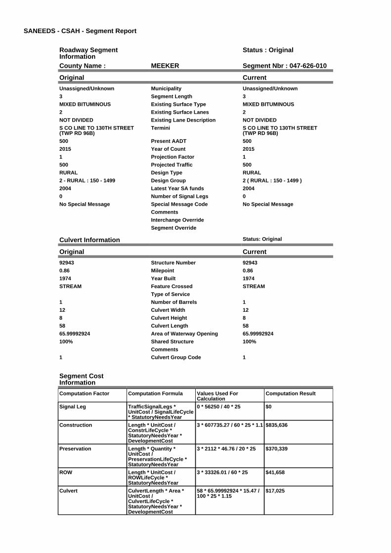
SANEEDS - CSAH - Segment Report
Roadway SegmentInformation
Status : Original
County Name : MEEKER Segment Nbr : 047-626-010
Original Current
Unassigned/Unknown Municipality Unassigned/Unknown
3 Segment Length 3
MIXED BITUMINOUS Existing Surface Type MIXED BITUMINOUS
2 Existing Surface Lanes 2
NOT DIVIDED Existing Lane Description NOT DIVIDED
S CO LINE TO 130TH STREET(TWP RD 96B)
Termini S CO LINE TO 130TH STREET(TWP RD 96B)
500 Present AADT 500
2015 Year of Count 2015
1 Projection Factor 1
500 Projected Traffic 500
RURAL Design Type RURAL
2 - RURAL : 150 - 1499 Design Group 2 ( RURAL : 150 - 1499 )
2004 Latest Year SA funds 2004
0 Number of Signal Legs 0
No Special Message Special Message Code No Special Message
Comments
Interchange Override
Segment Override
Culvert Information Status: Original
Original Current
92943 Structure Number 92943
0.86 Milepoint 0.86
1974 Year Built 1974
STREAM Feature Crossed STREAM
Type of Service
1 Number of Barrels 1
12 Culvert Width 12
8 Culvert Height 8
58 Culvert Length 58
65.99992924 Area of Waterway Opening 65.99992924
100% Shared Structure 100%
Comments
1 Culvert Group Code 1
Segment CostInformation
Computation Factor Computation Formula Values Used ForCalculation
Computation Result
Signal Leg TrafficSignalLegs *UnitCost / SignalLifeCycle* StatutoryNeedsYear
0 * 56250 / 40 * 25 $0
Construction Length * UnitCost /ConstrLifeCycle *StatutoryNeedsYear *DevelopmentCost
3 * 607735.27 / 60 * 25 * 1.1 $835,636
Preservation Length * Quantity *UnitCost /PreservationLifeCycle *StatutoryNeedsYear
3 * 2112 * 46.76 / 20 * 25 $370,339
ROW Length * UnitCost /ROWLifeCycle *StatutoryNeedsYear
3 * 33326.01 / 60 * 25 $41,658
Culvert CulvertLength * Area *UnitCost /CulvertLifeCycle *StatutoryNeedsYear *DevelopmentCost
58 * 65.99992924 * 15.47 /100 * 25 * 1.15
$17,025

Total Segment Cost Signal Leg + Construction+ Preservation + ROW +Culvert
$0 + $835,636 + $370,339+ $41,658 + $17,025
$1,264,658

SANEEDS - CSAH - Segment Report
Roadway SegmentInformation
Status : Original
County Name : MEEKER Segment Nbr : 047-626-020
Original Current
Unassigned/Unknown Municipality Unassigned/Unknown
0.1 Segment Length 0.1
MIXED BITUMINOUS Existing Surface Type MIXED BITUMINOUS
2 Existing Surface Lanes 2
NOT DIVIDED Existing Lane Description NOT DIVIDED
130TH STREET (TWP RD 96) TO SOLIM CEDAR MILLS
Termini 130TH STREET (TWP RD 96) TO SOLIM CEDAR MILLS
500 Present AADT 500
2015 Year of Count 2015
1 Projection Factor 1
500 Projected Traffic 500
RURAL Design Type RURAL
2 - RURAL : 150 - 1499 Design Group 2 ( RURAL : 150 - 1499 )
2004 Latest Year SA funds 2004
0 Number of Signal Legs 0
No Special Message Special Message Code No Special Message
Comments
Interchange Override
Segment Override
Segment CostInformation
Computation Factor Computation Formula Values Used ForCalculation
Computation Result
Signal Leg TrafficSignalLegs *UnitCost / SignalLifeCycle* StatutoryNeedsYear
0 * 56250 / 40 * 25 $0
Construction Length * UnitCost /ConstrLifeCycle *StatutoryNeedsYear *DevelopmentCost
0.1 * 607735.27 / 60 * 25 *1.1
$27,855
Preservation Length * Quantity *UnitCost /PreservationLifeCycle *StatutoryNeedsYear
0.1 * 2112 * 46.76 / 20 * 25 $12,345
ROW Length * UnitCost /ROWLifeCycle *StatutoryNeedsYear
0.1 * 33326.01 / 60 * 25 $1,389
Total Segment Cost Signal Leg + Construction+ Preservation + ROW
$0 + $27,855 + $12,345 +$1,389
$41,589

SANEEDS - CSAH - Segment Report
Roadway SegmentInformation
Status : Original
County Name : MEEKER Segment Nbr : 047-626-040
Original Current
CEDAR MILLS Municipality CEDAR MILLS
0.4 Segment Length 0.4
MIXED BITUMINOUS Existing Surface Type MIXED BITUMINOUS
2 Existing Surface Lanes 2
NOT DIVIDED Existing Lane Description NOT DIVIDED
S LIMITS CEDAR MILLS TO TH 7 Termini S LIMITS CEDAR MILLS TO TH 7
500 Present AADT 500
2015 Year of Count 2015
1 Projection Factor 1
500 Projected Traffic 500
URBAN Design Type URBAN
5 - URBAN : 0 - 9999 Design Group 5 ( URBAN : 0 - 9999 )
2004 Latest Year SA funds 2004
0 Number of Signal Legs 0
No Special Message Special Message Code No Special Message
Comments
Interchange Override
Segment Override
Bridge Information Status: Original
Original Current
47504 Structure Number 47504
3.15 Milepoint 3.15
1963 Year Built 1963
S FK CROW RIVER Feature Crossed S FK CROW RIVER
Type of Service
Number of Spans
94.6 Bridge Length 94.6
31.8 Bridge Width 31.8
100% Shared Structure 100%
Comments
1 ( 0-149 ) Bridge Group Code 1 ( 0-149 )
Segment CostInformation
Computation Factor Computation Formula Values Used ForCalculation
Computation Result
Signal Leg TrafficSignalLegs *UnitCost / SignalLifeCycle* StatutoryNeedsYear
0 * 56250 / 40 * 25 $0
Construction Length * UnitCost /ConstrLifeCycle *StatutoryNeedsYear *DevelopmentCost
0.4 * 1892111.74 / 60 * 25 *1.15
$362,655
Preservation Length * Quantity *UnitCost /PreservationLifeCycle *StatutoryNeedsYear
0.4 * 2904 * 46.76 / 15 * 25 $90,527
ROW Length * UnitCost /ROWLifeCycle *StatutoryNeedsYear
0.4 * 10842.12 / 60 * 25 $1,807
Bridge BridgeLength *BridgeWidth * UnitCost /BridgeLifeCycle *StatutoryNeedsYear *DevelopmentCost
94.6 * 31.8 * 152 / 80 * 25 *1.15
$164,327
Total Segment Cost Signal Leg + Construction+ Preservation + ROW +Bridge
$0 + $362,655 + $90,527 +$1,807 + $164,327
$619,316

SANEEDS - CSAH - Segment Report
Roadway SegmentInformation
Status : Original
County Name : MEEKER Segment Nbr : 047-627-010
Original Current
Unassigned/Unknown Municipality Unassigned/Unknown
3.4 Segment Length 3.4
PORT CEMENT CONC Existing Surface Type PORT CEMENT CONC
2 Existing Surface Lanes 2
NOT DIVIDED Existing Lane Description NOT DIVIDED
TH 24 TO WEST LIMITS KINGSTON Termini TH 24 TO WEST LIMITS KINGSTON
550 Present AADT 550
2015 Year of Count 2015
1 Projection Factor 1
550 Projected Traffic 550
RURAL Design Type RURAL
2 - RURAL : 150 - 1499 Design Group 2 ( RURAL : 150 - 1499 )
2010 Latest Year SA funds 2010
0 Number of Signal Legs 0
No Special Message Special Message Code No Special Message
GRADED UNDER SP 47-627-06 FEDFUNDS IN 2009
SURFACED UNDER SAP 47-627-08STATE AID FUNDS IN 2010
Comments GRADED UNDER SP 47-627-06 FEDFUNDS IN 2009
SURFACED UNDER SAP 47-627-08STATE AID FUNDS IN 2010
Interchange Override
Segment Override
Segment CostInformation
Computation Factor Computation Formula Values Used ForCalculation
Computation Result
Signal Leg TrafficSignalLegs *UnitCost / SignalLifeCycle* StatutoryNeedsYear
0 * 56250 / 40 * 25 $0
Construction Length * UnitCost /ConstrLifeCycle *StatutoryNeedsYear *DevelopmentCost
3.4 * 607735.27 / 60 * 25 *1.1
$947,054
Preservation Length * Quantity *UnitCost /PreservationLifeCycle *StatutoryNeedsYear
3.4 * 2112 * 46.76 / 20 * 25 $419,718
ROW Length * UnitCost /ROWLifeCycle *StatutoryNeedsYear
3.4 * 33326.01 / 60 * 25 $47,212
Total Segment Cost Signal Leg + Construction+ Preservation + ROW
$0 + $947,054 + $419,718+ $47,212
$1,413,984

SANEEDS - CSAH - Segment Report
Roadway SegmentInformation
Status : Original
County Name : MEEKER Segment Nbr : 047-627-020
Original Current
KINGSTON Municipality KINGSTON
0.11 Segment Length 0.11
PORT CEMENT CONC Existing Surface Type PORT CEMENT CONC
2 Existing Surface Lanes 2
NOT DIVIDED Existing Lane Description NOT DIVIDED
W LIM KINGSTON TO 0.11 M E (TH15)
Termini W LIM KINGSTON TO 0.11 M E (TH15)
810 Present AADT 810
2015 Year of Count 2015
1 Projection Factor 1
810 Projected Traffic 810
RURAL Design Type RURAL
2 - RURAL : 150 - 1499 Design Group 2 ( RURAL : 150 - 1499 )
2010 Latest Year SA funds 2010
0 Number of Signal Legs 0
No Special Message Special Message Code No Special Message
GRADED IN 2009, SP 47-627-06
SURFACE 2010, SAP 47-627-08
Comments GRADED IN 2009, SP 47-627-06
SURFACE 2010, SAP 47-627-08
Interchange Override
Segment Override
Segment CostInformation
Computation Factor Computation Formula Values Used ForCalculation
Computation Result
Signal Leg TrafficSignalLegs *UnitCost / SignalLifeCycle* StatutoryNeedsYear
0 * 56250 / 40 * 25 $0
Construction Length * UnitCost /ConstrLifeCycle *StatutoryNeedsYear *DevelopmentCost
0.11 * 607735.27 / 60 * 25 *1.1
$30,640
Preservation Length * Quantity *UnitCost /PreservationLifeCycle *StatutoryNeedsYear
0.11 * 2112 * 46.76 / 20 * 25 $13,579
ROW Length * UnitCost /ROWLifeCycle *StatutoryNeedsYear
0.11 * 33326.01 / 60 * 25 $1,527
Total Segment Cost Signal Leg + Construction+ Preservation + ROW
$0 + $30,640 + $13,579 +$1,527
$45,746

SANEEDS - CSAH - Segment Report
Roadway SegmentInformation
Status : Original
County Name : MEEKER Segment Nbr : 047-627-021
Original Current
KINGSTON Municipality KINGSTON
0.08 Segment Length 0.08
MIXED BITUMINOUS Existing Surface Type MIXED BITUMINOUS
2 Existing Surface Lanes 2
NOT DIVIDED Existing Lane Description NOT DIVIDED
0.11 M TO 0.19 M E OF W LIMSKINGSTON
Termini 0.11 M TO 0.19 M E OF W LIMSKINGSTON
810 Present AADT 810
2015 Year of Count 2015
1 Projection Factor 1
810 Projected Traffic 810
URBAN Design Type URBAN
5 - URBAN : 0 - 9999 Design Group 5 ( URBAN : 0 - 9999 )
1973 Latest Year SA funds 1973
0 Number of Signal Legs 0
No Special Message Special Message Code No Special Message
Comments
Interchange Override
Segment Override
Segment CostInformation
Computation Factor Computation Formula Values Used ForCalculation
Computation Result
Signal Leg TrafficSignalLegs *UnitCost / SignalLifeCycle* StatutoryNeedsYear
0 * 56250 / 40 * 25 $0
Construction Length * UnitCost /ConstrLifeCycle *StatutoryNeedsYear *DevelopmentCost
0.08 * 1892111.74 / 60 * 25* 1.15
$72,531
Preservation Length * Quantity *UnitCost /PreservationLifeCycle *StatutoryNeedsYear
0.08 * 2904 * 46.76 / 15 * 25 $18,105
ROW Length * UnitCost /ROWLifeCycle *StatutoryNeedsYear
0.08 * 10842.12 / 60 * 25 $361
Total Segment Cost Signal Leg + Construction+ Preservation + ROW
$0 + $72,531 + $18,105 +$361
$90,997

SANEEDS - CSAH - Segment Report
Roadway SegmentInformation
Status : Original
County Name : MEEKER Segment Nbr : 047-627-022
Original Current
KINGSTON Municipality KINGSTON
0.19 Segment Length 0.19
MIXED BITUMINOUS Existing Surface Type MIXED BITUMINOUS
2 Existing Surface Lanes 2
NOT DIVIDED Existing Lane Description NOT DIVIDED
0.19 M TO 0.38 M E OF W LIMSKINGSTON
Termini 0.19 M TO 0.38 M E OF W LIMSKINGSTON
650 Present AADT 650
2015 Year of Count 2015
1 Projection Factor 1
650 Projected Traffic 650
URBAN Design Type URBAN
5 - URBAN : 0 - 9999 Design Group 5 ( URBAN : 0 - 9999 )
1973 Latest Year SA funds 1973
0 Number of Signal Legs 0
No Special Message Special Message Code No Special Message
Comments
Interchange Override
Segment Override
Segment CostInformation
Computation Factor Computation Formula Values Used ForCalculation
Computation Result
Signal Leg TrafficSignalLegs *UnitCost / SignalLifeCycle* StatutoryNeedsYear
0 * 56250 / 40 * 25 $0
Construction Length * UnitCost /ConstrLifeCycle *StatutoryNeedsYear *DevelopmentCost
0.19 * 1892111.74 / 60 * 25* 1.15
$172,261
Preservation Length * Quantity *UnitCost /PreservationLifeCycle *StatutoryNeedsYear
0.19 * 2904 * 46.76 / 15 * 25 $43,000
ROW Length * UnitCost /ROWLifeCycle *StatutoryNeedsYear
0.19 * 10842.12 / 60 * 25 $858
Total Segment Cost Signal Leg + Construction+ Preservation + ROW
$0 + $172,261 + $43,000 +$858
$216,119

SANEEDS - CSAH - Segment Report
Roadway SegmentInformation
Status : Original
County Name : MEEKER Segment Nbr : 047-627-023
Original Current
KINGSTON Municipality KINGSTON
0.12 Segment Length 0.12
MIXED BITUMINOUS Existing Surface Type MIXED BITUMINOUS
2 Existing Surface Lanes 2
NOT DIVIDED Existing Lane Description NOT DIVIDED
0.38 M E OF W LIM TO E LIMSKINGSTON
Termini 0.38 M E OF W LIM TO E LIMSKINGSTON
650 Present AADT 650
2015 Year of Count 2015
1 Projection Factor 1
650 Projected Traffic 650
RURAL Design Type RURAL
2 - RURAL : 150 - 1499 Design Group 2 ( RURAL : 150 - 1499 )
1973 Latest Year SA funds 1973
0 Number of Signal Legs 0
No Special Message Special Message Code No Special Message
Comments
Interchange Override
Segment Override
Segment CostInformation
Computation Factor Computation Formula Values Used ForCalculation
Computation Result
Signal Leg TrafficSignalLegs *UnitCost / SignalLifeCycle* StatutoryNeedsYear
0 * 56250 / 40 * 25 $0
Construction Length * UnitCost /ConstrLifeCycle *StatutoryNeedsYear *DevelopmentCost
0.12 * 607735.27 / 60 * 25 *1.1
$33,425
Preservation Length * Quantity *UnitCost /PreservationLifeCycle *StatutoryNeedsYear
0.12 * 2112 * 46.76 / 20 * 25 $14,814
ROW Length * UnitCost /ROWLifeCycle *StatutoryNeedsYear
0.12 * 33326.01 / 60 * 25 $1,666
Total Segment Cost Signal Leg + Construction+ Preservation + ROW
$0 + $33,425 + $14,814 +$1,666
$49,905

SANEEDS - CSAH - Segment Report
Roadway SegmentInformation
Status : Original
County Name : MEEKER Segment Nbr : 047-627-024
Original Current
Unassigned/Unknown Municipality Unassigned/Unknown
0.1 Segment Length 0.1
MIXED BITUMINOUS Existing Surface Type MIXED BITUMINOUS
2 Existing Surface Lanes 2
NOT DIVIDED Existing Lane Description NOT DIVIDED
E LIMS KINGSTON TO 0.10 M E Termini E LIMS KINGSTON TO 0.10 M E
650 Present AADT 650
2015 Year of Count 2015
1 Projection Factor 1
650 Projected Traffic 650
RURAL Design Type RURAL
2 - RURAL : 150 - 1499 Design Group 2 ( RURAL : 150 - 1499 )
1973 Latest Year SA funds 1973
0 Number of Signal Legs 0
No Special Message Special Message Code No Special Message
Comments
Interchange Override
Segment Override
Segment CostInformation
Computation Factor Computation Formula Values Used ForCalculation
Computation Result
Signal Leg TrafficSignalLegs *UnitCost / SignalLifeCycle* StatutoryNeedsYear
0 * 56250 / 40 * 25 $0
Construction Length * UnitCost /ConstrLifeCycle *StatutoryNeedsYear *DevelopmentCost
0.1 * 607735.27 / 60 * 25 *1.1
$27,855
Preservation Length * Quantity *UnitCost /PreservationLifeCycle *StatutoryNeedsYear
0.1 * 2112 * 46.76 / 20 * 25 $12,345
ROW Length * UnitCost /ROWLifeCycle *StatutoryNeedsYear
0.1 * 33326.01 / 60 * 25 $1,389
Total Segment Cost Signal Leg + Construction+ Preservation + ROW
$0 + $27,855 + $12,345 +$1,389
$41,589

SANEEDS - CSAH - Segment Report
Roadway SegmentInformation
Status : Original
County Name : MEEKER Segment Nbr : 047-627-030
Original Current
Unassigned/Unknown Municipality Unassigned/Unknown
2.7 Segment Length 2.7
MIXED BITUMINOUS Existing Surface Type MIXED BITUMINOUS
2 Existing Surface Lanes 2
NOT DIVIDED Existing Lane Description NOT DIVIDED
0.1 MI E OF E LIM KINGSTON TO ECO LINE
Termini 0.1 MI E OF E LIM KINGSTON TO ECO LINE
650 Present AADT 650
2015 Year of Count 2015
1 Projection Factor 1
650 Projected Traffic 650
RURAL Design Type RURAL
2 - RURAL : 150 - 1499 Design Group 2 ( RURAL : 150 - 1499 )
2000 Latest Year SA funds 2000
0 Number of Signal Legs 0
No Special Message Special Message Code No Special Message
PROJECT SAP 47-627-07 GRADEDIN 2011 & PAVED IN 2012
Comments PROJECT SAP 47-627-07 GRADEDIN 2011 & PAVED IN 2012
Interchange Override
Segment Override
Segment CostInformation
Computation Factor Computation Formula Values Used ForCalculation
Computation Result
Signal Leg TrafficSignalLegs *UnitCost / SignalLifeCycle* StatutoryNeedsYear
0 * 56250 / 40 * 25 $0
Construction Length * UnitCost /ConstrLifeCycle *StatutoryNeedsYear *DevelopmentCost
2.7 * 607735.27 / 60 * 25 *1.1
$752,072
Preservation Length * Quantity *UnitCost /PreservationLifeCycle *StatutoryNeedsYear
2.7 * 2112 * 46.76 / 20 * 25 $333,305
ROW Length * UnitCost /ROWLifeCycle *StatutoryNeedsYear
2.7 * 33326.01 / 60 * 25 $37,492
Total Segment Cost Signal Leg + Construction+ Preservation + ROW
$0 + $752,072 + $333,305+ $37,492
$1,122,869

SANEEDS - CSAH - Segment Report
Roadway SegmentInformation
Status : Original
County Name : MEEKER Segment Nbr : 047-628-010
Original Current
Unassigned/Unknown Municipality Unassigned/Unknown
3.5 Segment Length 3.5
MIXED BITUMINOUS Existing Surface Type MIXED BITUMINOUS
2 Existing Surface Lanes 2
NOT DIVIDED Existing Lane Description NOT DIVIDED
WEST COUNTY LINE TO TH 4 Termini WEST COUNTY LINE TO TH 4
170 Present AADT 170
2015 Year of Count 2015
1 Projection Factor 1
170 Projected Traffic 170
RURAL Design Type RURAL
2 - RURAL : 150 - 1499 Design Group 2 ( RURAL : 150 - 1499 )
2000 Latest Year SA funds 2000
0 Number of Signal Legs 0
No Special Message Special Message Code No Special Message
Comments
Interchange Override
Segment Override
Segment CostInformation
Computation Factor Computation Formula Values Used ForCalculation
Computation Result
Signal Leg TrafficSignalLegs *UnitCost / SignalLifeCycle* StatutoryNeedsYear
0 * 56250 / 40 * 25 $0
Construction Length * UnitCost /ConstrLifeCycle *StatutoryNeedsYear *DevelopmentCost
3.5 * 607735.27 / 60 * 25 *1.1
$974,909
Preservation Length * Quantity *UnitCost /PreservationLifeCycle *StatutoryNeedsYear
3.5 * 2112 * 46.76 / 20 * 25 $432,062
ROW Length * UnitCost /ROWLifeCycle *StatutoryNeedsYear
3.5 * 33326.01 / 60 * 25 $48,600
Total Segment Cost Signal Leg + Construction+ Preservation + ROW
$0 + $974,909 + $432,062+ $48,600
$1,455,571

SANEEDS - CSAH - Segment Report
Roadway SegmentInformation
Status : Original
County Name : MEEKER Segment Nbr : 047-628-020
Original Current
Unassigned/Unknown Municipality Unassigned/Unknown
5 Segment Length 5
MIXED BITUMINOUS Existing Surface Type MIXED BITUMINOUS
2 Existing Surface Lanes 2
NOT DIVIDED Existing Lane Description NOT DIVIDED
TH 4 TO CSAH 1 Termini TH 4 TO CSAH 1
345 Present AADT 345
2015 Year of Count 2015
1 Projection Factor 1
345 Projected Traffic 345
RURAL Design Type RURAL
2 - RURAL : 150 - 1499 Design Group 2 ( RURAL : 150 - 1499 )
1996 Latest Year SA funds 1996
0 Number of Signal Legs 0
No Special Message Special Message Code No Special Message
Comments
Interchange Override
Segment Override
Segment CostInformation
Computation Factor Computation Formula Values Used ForCalculation
Computation Result
Signal Leg TrafficSignalLegs *UnitCost / SignalLifeCycle* StatutoryNeedsYear
0 * 56250 / 40 * 25 $0
Construction Length * UnitCost /ConstrLifeCycle *StatutoryNeedsYear *DevelopmentCost
5 * 607735.27 / 60 * 25 * 1.1 $1,392,727
Preservation Length * Quantity *UnitCost /PreservationLifeCycle *StatutoryNeedsYear
5 * 2112 * 46.76 / 20 * 25 $617,232
ROW Length * UnitCost /ROWLifeCycle *StatutoryNeedsYear
5 * 33326.01 / 60 * 25 $69,429
Total Segment Cost Signal Leg + Construction+ Preservation + ROW
$0 + $1,392,727 + $617,232+ $69,429
$2,079,388

SANEEDS - CSAH - Segment Report
Roadway SegmentInformation
Status : Original
County Name : MEEKER Segment Nbr : 047-628-030
Original Current
Unassigned/Unknown Municipality Unassigned/Unknown
2.5 Segment Length 2.5
BIT CONC OR ASPH Existing Surface Type BIT CONC OR ASPH
2 Existing Surface Lanes 2
NOT DIVIDED Existing Lane Description NOT DIVIDED
CSAH 1 TO 610TH AVENUE (TWPRD 72)
Termini CSAH 1 TO 610TH AVENUE (TWPRD 72)
260 Present AADT 260
2015 Year of Count 2015
1 Projection Factor 1
260 Projected Traffic 260
RURAL Design Type RURAL
2 - RURAL : 150 - 1499 Design Group 2 ( RURAL : 150 - 1499 )
2015 Latest Year SA funds 2015
0 Number of Signal Legs 0
No Special Message Special Message Code No Special Message
2015 SP 047-628-009 OL Comments 2015 SP 047-628-009 OL
Interchange Override
Segment Override
Segment CostInformation
Computation Factor Computation Formula Values Used ForCalculation
Computation Result
Signal Leg TrafficSignalLegs *UnitCost / SignalLifeCycle* StatutoryNeedsYear
0 * 56250 / 40 * 25 $0
Construction Length * UnitCost /ConstrLifeCycle *StatutoryNeedsYear *DevelopmentCost
2.5 * 607735.27 / 60 * 25 *1.1
$696,363
Preservation Length * Quantity *UnitCost /PreservationLifeCycle *StatutoryNeedsYear
2.5 * 2112 * 46.76 / 20 * 25 $308,616
ROW Length * UnitCost /ROWLifeCycle *StatutoryNeedsYear
2.5 * 33326.01 / 60 * 25 $34,715
Total Segment Cost Signal Leg + Construction+ Preservation + ROW
$0 + $696,363 + $308,616+ $34,715
$1,039,694
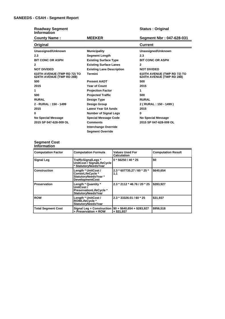
SANEEDS - CSAH - Segment Report
Roadway SegmentInformation
Status : Original
County Name : MEEKER Segment Nbr : 047-628-031
Original Current
Unassigned/Unknown Municipality Unassigned/Unknown
2.3 Segment Length 2.3
BIT CONC OR ASPH Existing Surface Type BIT CONC OR ASPH
2 Existing Surface Lanes 2
NOT DIVIDED Existing Lane Description NOT DIVIDED
610TH AVENUE (TWP RD 72) TO624TH AVENUE (TWP RD 288)
Termini 610TH AVENUE (TWP RD 72) TO624TH AVENUE (TWP RD 288)
500 Present AADT 500
2015 Year of Count 2015
1 Projection Factor 1
500 Projected Traffic 500
RURAL Design Type RURAL
2 - RURAL : 150 - 1499 Design Group 2 ( RURAL : 150 - 1499 )
2015 Latest Year SA funds 2015
0 Number of Signal Legs 0
No Special Message Special Message Code No Special Message
2015 SP 047-628-009 OL Comments 2015 SP 047-628-009 OL
Interchange Override
Segment Override
Segment CostInformation
Computation Factor Computation Formula Values Used ForCalculation
Computation Result
Signal Leg TrafficSignalLegs *UnitCost / SignalLifeCycle* StatutoryNeedsYear
0 * 56250 / 40 * 25 $0
Construction Length * UnitCost /ConstrLifeCycle *StatutoryNeedsYear *DevelopmentCost
2.3 * 607735.27 / 60 * 25 *1.1
$640,654
Preservation Length * Quantity *UnitCost /PreservationLifeCycle *StatutoryNeedsYear
2.3 * 2112 * 46.76 / 20 * 25 $283,927
ROW Length * UnitCost /ROWLifeCycle *StatutoryNeedsYear
2.3 * 33326.01 / 60 * 25 $31,937
Total Segment Cost Signal Leg + Construction+ Preservation + ROW
$0 + $640,654 + $283,927+ $31,937
$956,518

SANEEDS - CSAH - Segment Report
Roadway SegmentInformation
Status : Original
County Name : MEEKER Segment Nbr : 047-628-040
Original Current
Unassigned/Unknown Municipality Unassigned/Unknown
1 Segment Length 1
BIT CONC OR ASPH Existing Surface Type BIT CONC OR ASPH
2 Existing Surface Lanes 2
NOT DIVIDED Existing Lane Description NOT DIVIDED
624TH AVENUE (TWP RD 288) TOTH 22
Termini 624TH AVENUE (TWP RD 288) TOTH 22
190 Present AADT 190
2015 Year of Count 2015
1 Projection Factor 1
190 Projected Traffic 190
RURAL Design Type RURAL
2 - RURAL : 150 - 1499 Design Group 2 ( RURAL : 150 - 1499 )
2015 Latest Year SA funds 2015
0 Number of Signal Legs 0
No Special Message Special Message Code No Special Message
2015 SP 047-628-009 OL Comments 2015 SP 047-628-009 OL
Interchange Override
Segment Override
Segment CostInformation
Computation Factor Computation Formula Values Used ForCalculation
Computation Result
Signal Leg TrafficSignalLegs *UnitCost / SignalLifeCycle* StatutoryNeedsYear
0 * 56250 / 40 * 25 $0
Construction Length * UnitCost /ConstrLifeCycle *StatutoryNeedsYear *DevelopmentCost
1 * 607735.27 / 60 * 25 * 1.1 $278,545
Preservation Length * Quantity *UnitCost /PreservationLifeCycle *StatutoryNeedsYear
1 * 2112 * 46.76 / 20 * 25 $123,446
ROW Length * UnitCost /ROWLifeCycle *StatutoryNeedsYear
1 * 33326.01 / 60 * 25 $13,886
Total Segment Cost Signal Leg + Construction+ Preservation + ROW
$0 + $278,545 + $123,446+ $13,886
$415,877

SANEEDS - CSAH - Segment Report
Roadway SegmentInformation
Status : Original
County Name : MEEKER Segment Nbr : 047-629-010
Original Current
Unassigned/Unknown Municipality Unassigned/Unknown
1 Segment Length 1
MIXED BITUMINOUS Existing Surface Type MIXED BITUMINOUS
2 Existing Surface Lanes 2
NOT DIVIDED Existing Lane Description NOT DIVIDED
CSAH 15 TO E CO LINE Termini CSAH 15 TO E CO LINE
175 Present AADT 175
2015 Year of Count 2015
1 Projection Factor 1
175 Projected Traffic 175
RURAL Design Type RURAL
2 - RURAL : 150 - 1499 Design Group 2 ( RURAL : 150 - 1499 )
2013 Latest Year SA funds 2013
0 Number of Signal Legs 0
No Special Message Special Message Code No Special Message
2013 SAP 047-629-002 Comments 2013 SAP 047-629-002
Interchange Override
Segment Override
Segment CostInformation
Computation Factor Computation Formula Values Used ForCalculation
Computation Result
Signal Leg TrafficSignalLegs *UnitCost / SignalLifeCycle* StatutoryNeedsYear
0 * 56250 / 40 * 25 $0
Construction Length * UnitCost /ConstrLifeCycle *StatutoryNeedsYear *DevelopmentCost
1 * 607735.27 / 60 * 25 * 1.1 $278,545
Preservation Length * Quantity *UnitCost /PreservationLifeCycle *StatutoryNeedsYear
1 * 2112 * 46.76 / 20 * 25 $123,446
ROW Length * UnitCost /ROWLifeCycle *StatutoryNeedsYear
1 * 33326.01 / 60 * 25 $13,886
Total Segment Cost Signal Leg + Construction+ Preservation + ROW
$0 + $278,545 + $123,446+ $13,886
$415,877

SANEEDS - CSAH - Segment Report
Roadway SegmentInformation
Status : Original
County Name : MEEKER Segment Nbr : 047-630-010
Original Current
Unassigned/Unknown Municipality Unassigned/Unknown
2.3 Segment Length 2.3
AGGREGATE SURF Existing Surface Type AGGREGATE SURF
2 Existing Surface Lanes 2
NOT DIVIDED Existing Lane Description NOT DIVIDED
CSAH 16 TO 340TH STREET (TWPRD 46)
Termini CSAH 16 TO 340TH STREET (TWPRD 46)
60 Present AADT 60
2015 Year of Count 2015
1 Projection Factor 1
60 Projected Traffic 60
RURAL Design Type RURAL
1 - RURAL : 0 - 149 Design Group 1 ( RURAL : 0 - 149 )
2000 Latest Year SA funds 2000
0 Number of Signal Legs 0
No Special Message Special Message Code No Special Message
Comments
Interchange Override
Segment Override
Segment CostInformation
Computation Factor Computation Formula Values Used ForCalculation
Computation Result
Construction Length * UnitCost /ConstrLifeCycle *StatutoryNeedsYear *DevelopmentCost
2.3 * 303867.64 / 60 * 25 *1.1
$320,327
Preservation Length * Quantity *UnitCost /PreservationLifeCycle *StatutoryNeedsYear
2.3 * 546 * 10.3 / 2 * 25 $161,684
ROW Length * UnitCost /ROWLifeCycle *StatutoryNeedsYear
2.3 * 0 / 60 * 25 $0
Total Segment Cost Construction +Preservation + ROW
$320,327 + $161,684 + $0 $482,011
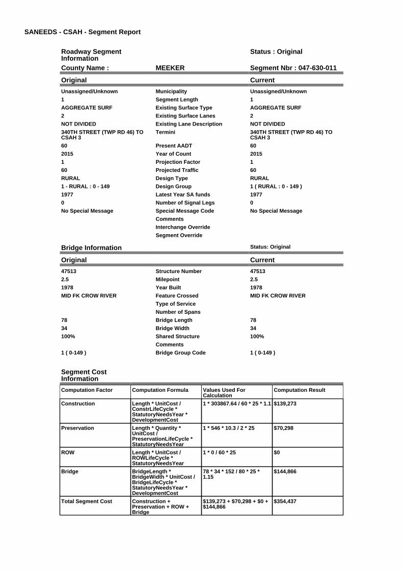
SANEEDS - CSAH - Segment Report
Roadway SegmentInformation
Status : Original
County Name : MEEKER Segment Nbr : 047-630-011
Original Current
Unassigned/Unknown Municipality Unassigned/Unknown
1 Segment Length 1
AGGREGATE SURF Existing Surface Type AGGREGATE SURF
2 Existing Surface Lanes 2
NOT DIVIDED Existing Lane Description NOT DIVIDED
340TH STREET (TWP RD 46) TOCSAH 3
Termini 340TH STREET (TWP RD 46) TOCSAH 3
60 Present AADT 60
2015 Year of Count 2015
1 Projection Factor 1
60 Projected Traffic 60
RURAL Design Type RURAL
1 - RURAL : 0 - 149 Design Group 1 ( RURAL : 0 - 149 )
1977 Latest Year SA funds 1977
0 Number of Signal Legs 0
No Special Message Special Message Code No Special Message
Comments
Interchange Override
Segment Override
Bridge Information Status: Original
Original Current
47513 Structure Number 47513
2.5 Milepoint 2.5
1978 Year Built 1978
MID FK CROW RIVER Feature Crossed MID FK CROW RIVER
Type of Service
Number of Spans
78 Bridge Length 78
34 Bridge Width 34
100% Shared Structure 100%
Comments
1 ( 0-149 ) Bridge Group Code 1 ( 0-149 )
Segment CostInformation
Computation Factor Computation Formula Values Used ForCalculation
Computation Result
Construction Length * UnitCost /ConstrLifeCycle *StatutoryNeedsYear *DevelopmentCost
1 * 303867.64 / 60 * 25 * 1.1 $139,273
Preservation Length * Quantity *UnitCost /PreservationLifeCycle *StatutoryNeedsYear
1 * 546 * 10.3 / 2 * 25 $70,298
ROW Length * UnitCost /ROWLifeCycle *StatutoryNeedsYear
1 * 0 / 60 * 25 $0
Bridge BridgeLength *BridgeWidth * UnitCost /BridgeLifeCycle *StatutoryNeedsYear *DevelopmentCost
78 * 34 * 152 / 80 * 25 *1.15
$144,866
Total Segment Cost Construction +Preservation + ROW +Bridge
$139,273 + $70,298 + $0 +$144,866
$354,437
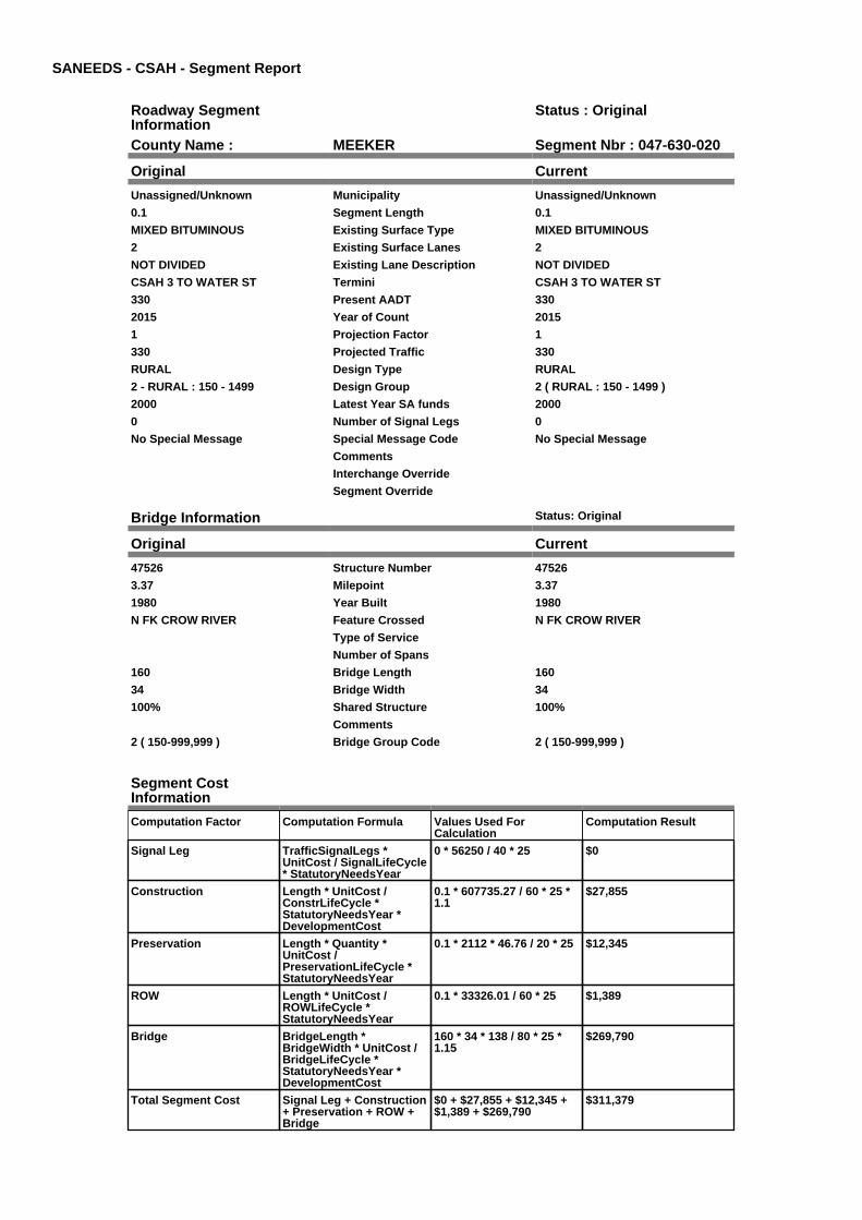
SANEEDS - CSAH - Segment Report
Roadway SegmentInformation
Status : Original
County Name : MEEKER Segment Nbr : 047-630-020
Original Current
Unassigned/Unknown Municipality Unassigned/Unknown
0.1 Segment Length 0.1
MIXED BITUMINOUS Existing Surface Type MIXED BITUMINOUS
2 Existing Surface Lanes 2
NOT DIVIDED Existing Lane Description NOT DIVIDED
CSAH 3 TO WATER ST Termini CSAH 3 TO WATER ST
330 Present AADT 330
2015 Year of Count 2015
1 Projection Factor 1
330 Projected Traffic 330
RURAL Design Type RURAL
2 - RURAL : 150 - 1499 Design Group 2 ( RURAL : 150 - 1499 )
2000 Latest Year SA funds 2000
0 Number of Signal Legs 0
No Special Message Special Message Code No Special Message
Comments
Interchange Override
Segment Override
Bridge Information Status: Original
Original Current
47526 Structure Number 47526
3.37 Milepoint 3.37
1980 Year Built 1980
N FK CROW RIVER Feature Crossed N FK CROW RIVER
Type of Service
Number of Spans
160 Bridge Length 160
34 Bridge Width 34
100% Shared Structure 100%
Comments
2 ( 150-999,999 ) Bridge Group Code 2 ( 150-999,999 )
Segment CostInformation
Computation Factor Computation Formula Values Used ForCalculation
Computation Result
Signal Leg TrafficSignalLegs *UnitCost / SignalLifeCycle* StatutoryNeedsYear
0 * 56250 / 40 * 25 $0
Construction Length * UnitCost /ConstrLifeCycle *StatutoryNeedsYear *DevelopmentCost
0.1 * 607735.27 / 60 * 25 *1.1
$27,855
Preservation Length * Quantity *UnitCost /PreservationLifeCycle *StatutoryNeedsYear
0.1 * 2112 * 46.76 / 20 * 25 $12,345
ROW Length * UnitCost /ROWLifeCycle *StatutoryNeedsYear
0.1 * 33326.01 / 60 * 25 $1,389
Bridge BridgeLength *BridgeWidth * UnitCost /BridgeLifeCycle *StatutoryNeedsYear *DevelopmentCost
160 * 34 * 138 / 80 * 25 *1.15
$269,790
Total Segment Cost Signal Leg + Construction+ Preservation + ROW +Bridge
$0 + $27,855 + $12,345 +$1,389 + $269,790
$311,379

SANEEDS - CSAH - Segment Report
Roadway SegmentInformation
Status : Original
County Name : MEEKER Segment Nbr : 047-630-030
Original Current
Unassigned/Unknown Municipality Unassigned/Unknown
0.6 Segment Length 0.6
MIXED BITUMINOUS Existing Surface Type MIXED BITUMINOUS
2 Existing Surface Lanes 2
NOT DIVIDED Existing Lane Description NOT DIVIDED
WATER ST TO 0.6 MI E Termini WATER ST TO 0.6 MI E
330 Present AADT 330
2015 Year of Count 2015
1 Projection Factor 1
330 Projected Traffic 330
RURAL Design Type RURAL
2 - RURAL : 150 - 1499 Design Group 2 ( RURAL : 150 - 1499 )
1979 Latest Year SA funds 1979
0 Number of Signal Legs 0
No Special Message Special Message Code No Special Message
Comments
Interchange Override
Segment Override
Segment CostInformation
Computation Factor Computation Formula Values Used ForCalculation
Computation Result
Signal Leg TrafficSignalLegs *UnitCost / SignalLifeCycle* StatutoryNeedsYear
0 * 56250 / 40 * 25 $0
Construction Length * UnitCost /ConstrLifeCycle *StatutoryNeedsYear *DevelopmentCost
0.6 * 607735.27 / 60 * 25 *1.1
$167,127
Preservation Length * Quantity *UnitCost /PreservationLifeCycle *StatutoryNeedsYear
0.6 * 2112 * 46.76 / 20 * 25 $74,068
ROW Length * UnitCost /ROWLifeCycle *StatutoryNeedsYear
0.6 * 33326.01 / 60 * 25 $8,332
Total Segment Cost Signal Leg + Construction+ Preservation + ROW
$0 + $167,127 + $74,068 +$8,332
$249,527

SANEEDS - CSAH - Segment Report
Roadway SegmentInformation
Status : Revised
County Name : MEEKER Segment Nbr : 047-630-040
Original Current
Unassigned/Unknown Municipality Unassigned/Unknown
4.6 Segment Length 4.6
MIXED BITUMINOUS Existing Surface Type MIXED BITUMINOUS
2 Existing Surface Lanes 2
NOT DIVIDED Existing Lane Description NOT DIVIDED
0.6 MI E OF WATER ST TO TH 55 Termini 0.6 MI E OF WATER ST TO TH 55
330 Present AADT 330
2015 Year of Count 2015
1 Projection Factor 1
330 Projected Traffic 330
RURAL Design Type RURAL
2 - RURAL : 150 - 1499 Design Group 2 ( RURAL : 150 - 1499 )
2016 Latest Year SA funds 2016
0 Number of Signal Legs 0
No Special Message Special Message Code No Special Message
2016 SAP 047-630-007 PH1 G&B,SM CULVERTS
Comments 2016 SAP 047-630-007 PH1 G&B,SM CULVERTS
Interchange Override
Segment Override
Segment CostInformation
Computation Factor Computation Formula Values Used ForCalculation
Computation Result
Signal Leg TrafficSignalLegs *UnitCost / SignalLifeCycle* StatutoryNeedsYear
0 * 56250 / 40 * 25 $0
Construction Length * UnitCost /ConstrLifeCycle *StatutoryNeedsYear *DevelopmentCost
4.6 * 607735.27 / 60 * 25 *1.1
$1,281,309
Preservation Length * Quantity *UnitCost /PreservationLifeCycle *StatutoryNeedsYear
4.6 * 2112 * 46.76 / 20 * 25 $567,853
ROW Length * UnitCost /ROWLifeCycle *StatutoryNeedsYear
4.6 * 33326.01 / 60 * 25 $63,875
Total Segment Cost Signal Leg + Construction+ Preservation + ROW
$0 + $1,281,309 + $567,853+ $63,875
$1,913,037

SANEEDS - CSAH - Segment Report
Roadway SegmentInformation
Status : Original
County Name : MEEKER Segment Nbr : 047-631-010
Original Current
Unassigned/Unknown Municipality Unassigned/Unknown
1 Segment Length 1
BIT CONC OR ASPH Existing Surface Type BIT CONC OR ASPH
2 Existing Surface Lanes 2
NOT DIVIDED Existing Lane Description NOT DIVIDED
CSAH 11 TO TH 12 Termini CSAH 11 TO TH 12
225 Present AADT 225
2015 Year of Count 2015
1 Projection Factor 1
225 Projected Traffic 225
RURAL Design Type RURAL
2 - RURAL : 150 - 1499 Design Group 2 ( RURAL : 150 - 1499 )
1992 Latest Year SA funds 1992
0 Number of Signal Legs 0
No Special Message Special Message Code No Special Message
Comments
Interchange Override
Segment Override
Segment CostInformation
Computation Factor Computation Formula Values Used ForCalculation
Computation Result
Signal Leg TrafficSignalLegs *UnitCost / SignalLifeCycle* StatutoryNeedsYear
0 * 56250 / 40 * 25 $0
Construction Length * UnitCost /ConstrLifeCycle *StatutoryNeedsYear *DevelopmentCost
1 * 607735.27 / 60 * 25 * 1.1 $278,545
Preservation Length * Quantity *UnitCost /PreservationLifeCycle *StatutoryNeedsYear
1 * 2112 * 46.76 / 20 * 25 $123,446
ROW Length * UnitCost /ROWLifeCycle *StatutoryNeedsYear
1 * 33326.01 / 60 * 25 $13,886
Total Segment Cost Signal Leg + Construction+ Preservation + ROW
$0 + $278,545 + $123,446+ $13,886
$415,877

SANEEDS - CSAH - Segment Report
Roadway SegmentInformation
Status : Original
County Name : MEEKER Segment Nbr : 047-631-020
Original Current
Unassigned/Unknown Municipality Unassigned/Unknown
4 Segment Length 4
BIT CONC OR ASPH Existing Surface Type BIT CONC OR ASPH
2 Existing Surface Lanes 2
NOT DIVIDED Existing Lane Description NOT DIVIDED
TH 12 TO CSAH 16 Termini TH 12 TO CSAH 16
280 Present AADT 280
2015 Year of Count 2015
1 Projection Factor 1
280 Projected Traffic 280
RURAL Design Type RURAL
2 - RURAL : 150 - 1499 Design Group 2 ( RURAL : 150 - 1499 )
1992 Latest Year SA funds 1992
0 Number of Signal Legs 0
No Special Message Special Message Code No Special Message
Comments
Interchange Override
Segment Override
Culvert Information Status: Original
Original Current
93733 Structure Number 93733
3.82 Milepoint 3.82
1985 Year Built 1985
STREAM Feature Crossed STREAM
Type of Service
1 Number of Barrels 1
12 Culvert Width 12
8 Culvert Height 8
52 Culvert Length 52
65.99992924 Area of Waterway Opening 65.99992924
100% Shared Structure 100%
Comments
1 Culvert Group Code 1
Segment CostInformation
Computation Factor Computation Formula Values Used ForCalculation
Computation Result
Signal Leg TrafficSignalLegs *UnitCost / SignalLifeCycle* StatutoryNeedsYear
0 * 56250 / 40 * 25 $0
Construction Length * UnitCost /ConstrLifeCycle *StatutoryNeedsYear *DevelopmentCost
4 * 607735.27 / 60 * 25 * 1.1 $1,114,181
Preservation Length * Quantity *UnitCost /PreservationLifeCycle *StatutoryNeedsYear
4 * 2112 * 46.76 / 20 * 25 $493,786
ROW Length * UnitCost /ROWLifeCycle *StatutoryNeedsYear
4 * 33326.01 / 60 * 25 $55,543
Culvert CulvertLength * Area *UnitCost /CulvertLifeCycle *StatutoryNeedsYear *DevelopmentCost
52 * 65.99992924 * 15.47 /100 * 25 * 1.15
$15,264
Total Segment Cost Signal Leg + Construction+ Preservation + ROW +Culvert
$0 + $1,114,181 + $493,786+ $55,543 + $15,264
$1,678,774

SANEEDS - CSAH - Segment Report
Roadway SegmentInformation
Status : Original
County Name : MEEKER Segment Nbr : 047-632-010
Original Current
Unassigned/Unknown Municipality Unassigned/Unknown
2 Segment Length 2
MIXED BITUMINOUS Existing Surface Type MIXED BITUMINOUS
2 Existing Surface Lanes 2
NOT DIVIDED Existing Lane Description NOT DIVIDED
CSAH 23 TO 2.0 MI NO Termini CSAH 23 TO 2.0 MI NO
155 Present AADT 155
2015 Year of Count 2015
1 Projection Factor 1
155 Projected Traffic 155
RURAL Design Type RURAL
2 - RURAL : 150 - 1499 Design Group 2 ( RURAL : 150 - 1499 )
1998 Latest Year SA funds 1998
0 Number of Signal Legs 0
No Special Message Special Message Code No Special Message
Comments
Interchange Override
Segment Override
Segment CostInformation
Computation Factor Computation Formula Values Used ForCalculation
Computation Result
Signal Leg TrafficSignalLegs *UnitCost / SignalLifeCycle* StatutoryNeedsYear
0 * 56250 / 40 * 25 $0
Construction Length * UnitCost /ConstrLifeCycle *StatutoryNeedsYear *DevelopmentCost
2 * 607735.27 / 60 * 25 * 1.1 $557,091
Preservation Length * Quantity *UnitCost /PreservationLifeCycle *StatutoryNeedsYear
2 * 2112 * 46.76 / 20 * 25 $246,893
ROW Length * UnitCost /ROWLifeCycle *StatutoryNeedsYear
2 * 33326.01 / 60 * 25 $27,772
Total Segment Cost Signal Leg + Construction+ Preservation + ROW
$0 + $557,091 + $246,893+ $27,772
$831,756

SANEEDS - CSAH - Segment Report
Roadway SegmentInformation
Status : Original
County Name : MEEKER Segment Nbr : 047-632-020
Original Current
Unassigned/Unknown Municipality Unassigned/Unknown
2 Segment Length 2
MIXED BITUMINOUS Existing Surface Type MIXED BITUMINOUS
2 Existing Surface Lanes 2
NOT DIVIDED Existing Lane Description NOT DIVIDED
2.0 MI N CSAH 23 TO CSAH 11 Termini 2.0 MI N CSAH 23 TO CSAH 11
155 Present AADT 155
2015 Year of Count 2015
1 Projection Factor 1
155 Projected Traffic 155
RURAL Design Type RURAL
2 - RURAL : 150 - 1499 Design Group 2 ( RURAL : 150 - 1499 )
1998 Latest Year SA funds 1998
0 Number of Signal Legs 0
No Special Message Special Message Code No Special Message
Comments
Interchange Override
Segment Override
Segment CostInformation
Computation Factor Computation Formula Values Used ForCalculation
Computation Result
Signal Leg TrafficSignalLegs *UnitCost / SignalLifeCycle* StatutoryNeedsYear
0 * 56250 / 40 * 25 $0
Construction Length * UnitCost /ConstrLifeCycle *StatutoryNeedsYear *DevelopmentCost
2 * 607735.27 / 60 * 25 * 1.1 $557,091
Preservation Length * Quantity *UnitCost /PreservationLifeCycle *StatutoryNeedsYear
2 * 2112 * 46.76 / 20 * 25 $246,893
ROW Length * UnitCost /ROWLifeCycle *StatutoryNeedsYear
2 * 33326.01 / 60 * 25 $27,772
Total Segment Cost Signal Leg + Construction+ Preservation + ROW
$0 + $557,091 + $246,893+ $27,772
$831,756

SANEEDS - CSAH - Segment Report
Roadway SegmentInformation
Status : Original
County Name : MEEKER Segment Nbr : 047-633-010
Original Current
Unassigned/Unknown Municipality Unassigned/Unknown
1.5 Segment Length 1.5
MIXED BITUMINOUS Existing Surface Type MIXED BITUMINOUS
2 Existing Surface Lanes 2
NOT DIVIDED Existing Lane Description NOT DIVIDED
CSAH 9 TO CSAH 14 Termini CSAH 9 TO CSAH 14
325 Present AADT 325
2015 Year of Count 2015
1 Projection Factor 1
325 Projected Traffic 325
RURAL Design Type RURAL
2 - RURAL : 150 - 1499 Design Group 2 ( RURAL : 150 - 1499 )
1991 Latest Year SA funds 1991
0 Number of Signal Legs 0
No Special Message Special Message Code No Special Message
Comments
Interchange Override
Segment Override
Segment CostInformation
Computation Factor Computation Formula Values Used ForCalculation
Computation Result
Signal Leg TrafficSignalLegs *UnitCost / SignalLifeCycle* StatutoryNeedsYear
0 * 56250 / 40 * 25 $0
Construction Length * UnitCost /ConstrLifeCycle *StatutoryNeedsYear *DevelopmentCost
1.5 * 607735.27 / 60 * 25 *1.1
$417,818
Preservation Length * Quantity *UnitCost /PreservationLifeCycle *StatutoryNeedsYear
1.5 * 2112 * 46.76 / 20 * 25 $185,170
ROW Length * UnitCost /ROWLifeCycle *StatutoryNeedsYear
1.5 * 33326.01 / 60 * 25 $20,829
Total Segment Cost Signal Leg + Construction+ Preservation + ROW
$0 + $417,818 + $185,170+ $20,829
$623,817

SANEEDS - CSAH - Segment Report
Roadway SegmentInformation
Status : Original
County Name : MEEKER Segment Nbr : 047-634-009
Original Current
LITCHFIELD Municipality LITCHFIELD
0.21 Segment Length 0.21
MIXED BITUMINOUS Existing Surface Type MIXED BITUMINOUS
2 Existing Surface Lanes 2
NOT DIVIDED Existing Lane Description NOT DIVIDED
TH 12 TO 260TH STREET (N LIMSLITCHFIELD)
Termini TH 12 TO 260TH STREET (N LIMSLITCHFIELD)
3850 Present AADT 3850
2015 Year of Count 2015
1 Projection Factor 1
3850 Projected Traffic 3850
RURAL Design Type RURAL
3 - RURAL : 1500 - 6999 Design Group 3 ( RURAL : 1500 - 6999 )
1992 Latest Year SA funds 1992
0 Number of Signal Legs 0
No Special Message Special Message Code No Special Message
Comments
Interchange Override
Segment Override
Segment CostInformation
Computation Factor Computation Formula Values Used ForCalculation
Computation Result
Signal Leg TrafficSignalLegs *UnitCost / SignalLifeCycle* StatutoryNeedsYear
0 * 56250 / 40 * 25 $0
Construction Length * UnitCost /ConstrLifeCycle *StatutoryNeedsYear *DevelopmentCost
0.21 * 922582.78 / 60 * 25 *1.1
$88,799
Preservation Length * Quantity *UnitCost /PreservationLifeCycle *StatutoryNeedsYear
0.21 * 2376 * 46.76 / 20 * 25 $29,164
ROW Length * UnitCost /ROWLifeCycle *StatutoryNeedsYear
0.21 * 72889.99 / 60 * 25 $6,378
Total Segment Cost Signal Leg + Construction+ Preservation + ROW
$0 + $88,799 + $29,164 +$6,378
$124,341

SANEEDS - CSAH - Segment Report
Roadway SegmentInformation
Status : Original
County Name : MEEKER Segment Nbr : 047-634-010
Original Current
LITCHFIELD Municipality LITCHFIELD
0.6 Segment Length 0.6
MIXED BITUMINOUS Existing Surface Type MIXED BITUMINOUS
2 Existing Surface Lanes 2
NOT DIVIDED Existing Lane Description NOT DIVIDED
260TH STREET (N LIMS) TO SOLIM LITCHFIELD (OUTSIDE)
Termini 260TH STREET (N LIMS) TO SOLIM LITCHFIELD (OUTSIDE)
3850 Present AADT 3850
2015 Year of Count 2015
1 Projection Factor 1
3850 Projected Traffic 3850
RURAL Design Type RURAL
3 - RURAL : 1500 - 6999 Design Group 3 ( RURAL : 1500 - 6999 )
1992 Latest Year SA funds 1992
0 Number of Signal Legs 0
No Special Message Special Message Code No Special Message
Comments
Interchange Override
Segment Override
Segment CostInformation
Computation Factor Computation Formula Values Used ForCalculation
Computation Result
Signal Leg TrafficSignalLegs *UnitCost / SignalLifeCycle* StatutoryNeedsYear
0 * 56250 / 40 * 25 $0
Construction Length * UnitCost /ConstrLifeCycle *StatutoryNeedsYear *DevelopmentCost
0.6 * 922582.78 / 60 * 25 *1.1
$253,710
Preservation Length * Quantity *UnitCost /PreservationLifeCycle *StatutoryNeedsYear
0.6 * 2376 * 46.76 / 20 * 25 $83,326
ROW Length * UnitCost /ROWLifeCycle *StatutoryNeedsYear
0.6 * 72889.99 / 60 * 25 $18,222
Total Segment Cost Signal Leg + Construction+ Preservation + ROW
$0 + $253,710 + $83,326 +$18,222
$355,258

SANEEDS - CSAH - Segment Report
Roadway SegmentInformation
Status : Original
County Name : MEEKER Segment Nbr : 047-634-011
Original Current
LITCHFIELD Municipality LITCHFIELD
0.4 Segment Length 0.4
MIXED BITUMINOUS Existing Surface Type MIXED BITUMINOUS
2 Existing Surface Lanes 2
NOT DIVIDED Existing Lane Description NOT DIVIDED
S LIM LITCHFIELD TO N JCT CSAH11
Termini S LIM LITCHFIELD TO N JCT CSAH11
3850 Present AADT 3850
2015 Year of Count 2015
1 Projection Factor 1
3850 Projected Traffic 3850
RURAL Design Type RURAL
3 - RURAL : 1500 - 6999 Design Group 3 ( RURAL : 1500 - 6999 )
1992 Latest Year SA funds 1992
0 Number of Signal Legs 0
No Special Message Special Message Code No Special Message
Comments
Interchange Override
Segment Override
Segment CostInformation
Computation Factor Computation Formula Values Used ForCalculation
Computation Result
Signal Leg TrafficSignalLegs *UnitCost / SignalLifeCycle* StatutoryNeedsYear
0 * 56250 / 40 * 25 $0
Construction Length * UnitCost /ConstrLifeCycle *StatutoryNeedsYear *DevelopmentCost
0.4 * 922582.78 / 60 * 25 *1.1
$169,140
Preservation Length * Quantity *UnitCost /PreservationLifeCycle *StatutoryNeedsYear
0.4 * 2376 * 46.76 / 20 * 25 $55,551
ROW Length * UnitCost /ROWLifeCycle *StatutoryNeedsYear
0.4 * 72889.99 / 60 * 25 $12,148
Total Segment Cost Signal Leg + Construction+ Preservation + ROW
$0 + $169,140 + $55,551 +$12,148
$236,839

SANEEDS - CSAH - Segment Report
Roadway SegmentInformation
Status : Original
County Name : MEEKER Segment Nbr : 047-634-012
Original Current
LITCHFIELD Municipality LITCHFIELD
0.5 Segment Length 0.5
MIXED BITUMINOUS Existing Surface Type MIXED BITUMINOUS
2 Existing Surface Lanes 2
NOT DIVIDED Existing Lane Description NOT DIVIDED
N JCT CSAH 11 TO TH 24 Termini N JCT CSAH 11 TO TH 24
3850 Present AADT 3850
2015 Year of Count 2015
1 Projection Factor 1
3850 Projected Traffic 3850
RURAL Design Type RURAL
3 - RURAL : 1500 - 6999 Design Group 3 ( RURAL : 1500 - 6999 )
1992 Latest Year SA funds 1992
0 Number of Signal Legs 0
No Special Message Special Message Code No Special Message
Comments
Interchange Override
Segment Override
Segment CostInformation
Computation Factor Computation Formula Values Used ForCalculation
Computation Result
Signal Leg TrafficSignalLegs *UnitCost / SignalLifeCycle* StatutoryNeedsYear
0 * 56250 / 40 * 25 $0
Construction Length * UnitCost /ConstrLifeCycle *StatutoryNeedsYear *DevelopmentCost
0.5 * 922582.78 / 60 * 25 *1.1
$211,425
Preservation Length * Quantity *UnitCost /PreservationLifeCycle *StatutoryNeedsYear
0.5 * 2376 * 46.76 / 20 * 25 $69,439
ROW Length * UnitCost /ROWLifeCycle *StatutoryNeedsYear
0.5 * 72889.99 / 60 * 25 $15,185
Total Segment Cost Signal Leg + Construction+ Preservation + ROW
$0 + $211,425 + $69,439 +$15,185
$296,049

SANEEDS - CSAH - Segment Report
Roadway SegmentInformation
Status : Revised
County Name : MEEKER Segment Nbr : 047-634-020
Original Current
Unassigned/Unknown Municipality Unassigned/Unknown
4 Segment Length 4
MIXED BITUMINOUS Existing Surface Type MIXED BITUMINOUS
2 Existing Surface Lanes 2
NOT DIVIDED Existing Lane Description NOT DIVIDED
TH 24 TO 315TH STREET (TWP RD129)
Termini TH 24 TO 315TH STREET (TWP RD129)
1150 Present AADT 1150
2015 Year of Count 2015
1 Projection Factor 1
1150 Projected Traffic 1150
RURAL Design Type RURAL
2 - RURAL : 150 - 1499 Design Group 2 ( RURAL : 150 - 1499 )
2016 Latest Year SA funds 2016
0 Number of Signal Legs 0
No Special Message Special Message Code No Special Message
2016 SAP 047-634-015 M&OL Comments 2016 SAP 047-634-015 M&OL
Interchange Override
Segment Override
Bridge Information Status: Original
Original Current
7230 Structure Number 7230
5.31 Milepoint 5.31
1963 Year Built 1963
N FK CROW RIVER Feature Crossed N FK CROW RIVER
Type of Service
Number of Spans
127.6 Bridge Length 127.6
27.7 Bridge Width 27.7
100% Shared Structure 100%
Comments
1 ( 0-149 ) Bridge Group Code 1 ( 0-149 )
Segment CostInformation
Computation Factor Computation Formula Values Used ForCalculation
Computation Result
Signal Leg TrafficSignalLegs *UnitCost / SignalLifeCycle* StatutoryNeedsYear
0 * 56250 / 40 * 25 $0
Construction Length * UnitCost /ConstrLifeCycle *StatutoryNeedsYear *DevelopmentCost
4 * 607735.27 / 60 * 25 * 1.1 $1,114,181
Preservation Length * Quantity *UnitCost /PreservationLifeCycle *StatutoryNeedsYear
4 * 2112 * 46.76 / 20 * 25 $493,786
ROW Length * UnitCost /ROWLifeCycle *StatutoryNeedsYear
4 * 33326.01 / 60 * 25 $55,543
Bridge BridgeLength *BridgeWidth * UnitCost /BridgeLifeCycle *StatutoryNeedsYear *DevelopmentCost
127.6 * 27.7 * 152 / 80 * 25* 1.15
$193,073
Total Segment Cost Signal Leg + Construction+ Preservation + ROW +Bridge
$0 + $1,114,181 + $493,786+ $55,543 + $193,073
$1,856,583

SANEEDS - CSAH - Segment Report
Roadway SegmentInformation
Status : Revised
County Name : MEEKER Segment Nbr : 047-634-030
Original Current
Unassigned/Unknown Municipality Unassigned/Unknown
2.5 Segment Length 2.5
MIXED BITUMINOUS Existing Surface Type MIXED BITUMINOUS
2 Existing Surface Lanes 2
NOT DIVIDED Existing Lane Description NOT DIVIDED
315TH STREET (CO RD 129) TO340TH STREET (CO RD 110)
Termini 315TH STREET (CO RD 129) TO340TH STREET (CO RD 110)
1150 Present AADT 1150
2015 Year of Count 2015
1 Projection Factor 1
1150 Projected Traffic 1150
RURAL Design Type RURAL
2 - RURAL : 150 - 1499 Design Group 2 ( RURAL : 150 - 1499 )
2016 Latest Year SA funds 2016
0 Number of Signal Legs 0
No Special Message Special Message Code No Special Message
2016 SAP 047-634-015 M&OL Comments 2016 SAP 047-634-015 M&OL
Interchange Override
Segment Override
Segment CostInformation
Computation Factor Computation Formula Values Used ForCalculation
Computation Result
Signal Leg TrafficSignalLegs *UnitCost / SignalLifeCycle* StatutoryNeedsYear
0 * 56250 / 40 * 25 $0
Construction Length * UnitCost /ConstrLifeCycle *StatutoryNeedsYear *DevelopmentCost
2.5 * 607735.27 / 60 * 25 *1.1
$696,363
Preservation Length * Quantity *UnitCost /PreservationLifeCycle *StatutoryNeedsYear
2.5 * 2112 * 46.76 / 20 * 25 $308,616
ROW Length * UnitCost /ROWLifeCycle *StatutoryNeedsYear
2.5 * 33326.01 / 60 * 25 $34,715
Total Segment Cost Signal Leg + Construction+ Preservation + ROW
$0 + $696,363 + $308,616+ $34,715
$1,039,694

SANEEDS - CSAH - Segment Report
Roadway SegmentInformation
Status : Revised
County Name : MEEKER Segment Nbr : 047-634-040
Original Current
Unassigned/Unknown Municipality Unassigned/Unknown
3.3 Segment Length 3.3
MIXED BITUMINOUS Existing Surface Type MIXED BITUMINOUS
2 Existing Surface Lanes 2
NOT DIVIDED Existing Lane Description NOT DIVIDED
340TH STREET (CO RD 110) TO365TH STREET (3.30 MI NORTH)
Termini 340TH STREET (CO RD 110) TO365TH STREET (3.30 MI NORTH)
860 Present AADT 860
2015 Year of Count 2015
1 Projection Factor 1
860 Projected Traffic 860
RURAL Design Type RURAL
2 - RURAL : 150 - 1499 Design Group 2 ( RURAL : 150 - 1499 )
2016 Latest Year SA funds 2016
0 Number of Signal Legs 0
No Special Message Special Message Code No Special Message
2016 SAP 047-634-015 M&OL Comments 2016 SAP 047-634-015 M&OL
Interchange Override
Segment Override
Segment CostInformation
Computation Factor Computation Formula Values Used ForCalculation
Computation Result
Signal Leg TrafficSignalLegs *UnitCost / SignalLifeCycle* StatutoryNeedsYear
0 * 56250 / 40 * 25 $0
Construction Length * UnitCost /ConstrLifeCycle *StatutoryNeedsYear *DevelopmentCost
3.3 * 607735.27 / 60 * 25 *1.1
$919,200
Preservation Length * Quantity *UnitCost /PreservationLifeCycle *StatutoryNeedsYear
3.3 * 2112 * 46.76 / 20 * 25 $407,373
ROW Length * UnitCost /ROWLifeCycle *StatutoryNeedsYear
3.3 * 33326.01 / 60 * 25 $45,823
Total Segment Cost Signal Leg + Construction+ Preservation + ROW
$0 + $919,200 + $407,373+ $45,823
$1,372,396

SANEEDS - CSAH - Segment Report
Roadway SegmentInformation
Status : Revised
County Name : MEEKER Segment Nbr : 047-634-050
Original Current
Unassigned/Unknown Municipality Unassigned/Unknown
2 Segment Length 2
MIXED BITUMINOUS Existing Surface Type MIXED BITUMINOUS
2 Existing Surface Lanes 2
NOT DIVIDED Existing Lane Description NOT DIVIDED
365TH STREET (3.3 MI N OF CO RD110) TO TH 55
Termini 365TH STREET (3.3 MI N OF CO RD110) TO TH 55
860 Present AADT 860
2015 Year of Count 2015
1 Projection Factor 1
860 Projected Traffic 860
RURAL Design Type RURAL
2 - RURAL : 150 - 1499 Design Group 2 ( RURAL : 150 - 1499 )
2016 Latest Year SA funds 2016
0 Number of Signal Legs 0
No Special Message Special Message Code No Special Message
2016 SAP 047-634-015 M&OL Comments 2016 SAP 047-634-015 M&OL
Interchange Override
Segment Override
Segment CostInformation
Computation Factor Computation Formula Values Used ForCalculation
Computation Result
Signal Leg TrafficSignalLegs *UnitCost / SignalLifeCycle* StatutoryNeedsYear
0 * 56250 / 40 * 25 $0
Construction Length * UnitCost /ConstrLifeCycle *StatutoryNeedsYear *DevelopmentCost
2 * 607735.27 / 60 * 25 * 1.1 $557,091
Preservation Length * Quantity *UnitCost /PreservationLifeCycle *StatutoryNeedsYear
2 * 2112 * 46.76 / 20 * 25 $246,893
ROW Length * UnitCost /ROWLifeCycle *StatutoryNeedsYear
2 * 33326.01 / 60 * 25 $27,772
Total Segment Cost Signal Leg + Construction+ Preservation + ROW
$0 + $557,091 + $246,893+ $27,772
$831,756

SANEEDS - CSAH - Segment Report
Roadway SegmentInformation
Status : Original
County Name : MEEKER Segment Nbr : 047-635-010
Original Current
Unassigned/Unknown Municipality Unassigned/Unknown
0.6 Segment Length 0.6
MIXED BITUMINOUS Existing Surface Type MIXED BITUMINOUS
2 Existing Surface Lanes 2
NOT DIVIDED Existing Lane Description NOT DIVIDED
TH 7 TO 140TH STREET (TWP RD100)
Termini TH 7 TO 140TH STREET (TWP RD100)
165 Present AADT 165
2015 Year of Count 2015
1 Projection Factor 1
165 Projected Traffic 165
RURAL Design Type RURAL
2 - RURAL : 150 - 1499 Design Group 2 ( RURAL : 150 - 1499 )
2004 Latest Year SA funds 2004
0 Number of Signal Legs 0
No Special Message Special Message Code No Special Message
SURFACED SAP 47-635-06 Comments SURFACED SAP 47-635-06
Interchange Override
Segment Override
Segment CostInformation
Computation Factor Computation Formula Values Used ForCalculation
Computation Result
Signal Leg TrafficSignalLegs *UnitCost / SignalLifeCycle* StatutoryNeedsYear
0 * 56250 / 40 * 25 $0
Construction Length * UnitCost /ConstrLifeCycle *StatutoryNeedsYear *DevelopmentCost
0.6 * 607735.27 / 60 * 25 *1.1
$167,127
Preservation Length * Quantity *UnitCost /PreservationLifeCycle *StatutoryNeedsYear
0.6 * 2112 * 46.76 / 20 * 25 $74,068
ROW Length * UnitCost /ROWLifeCycle *StatutoryNeedsYear
0.6 * 33326.01 / 60 * 25 $8,332
Total Segment Cost Signal Leg + Construction+ Preservation + ROW
$0 + $167,127 + $74,068 +$8,332
$249,527

SANEEDS - CSAH - Segment Report
Roadway SegmentInformation
Status : Original
County Name : MEEKER Segment Nbr : 047-635-011
Original Current
Unassigned/Unknown Municipality Unassigned/Unknown
1 Segment Length 1
MIXED BITUMINOUS Existing Surface Type MIXED BITUMINOUS
2 Existing Surface Lanes 2
NOT DIVIDED Existing Lane Description NOT DIVIDED
140TH STREET (TWP RD 100) TO150TH STREET (TWP RD 94)
Termini 140TH STREET (TWP RD 100) TO150TH STREET (TWP RD 94)
165 Present AADT 165
2015 Year of Count 2015
1 Projection Factor 1
165 Projected Traffic 165
RURAL Design Type RURAL
2 - RURAL : 150 - 1499 Design Group 2 ( RURAL : 150 - 1499 )
2004 Latest Year SA funds 2004
0 Number of Signal Legs 0
No Special Message Special Message Code No Special Message
SURFACED SAP 47-635-06 Comments SURFACED SAP 47-635-06
Interchange Override
Segment Override
Bridge Information Status: Original
Original Current
47521 Structure Number 47521
1.28 Milepoint 1.28
1979 Year Built 1979
S FK CROW RIVER Feature Crossed S FK CROW RIVER
Type of Service
Number of Spans
82 Bridge Length 82
34 Bridge Width 34
100% Shared Structure 100%
Comments
1 ( 0-149 ) Bridge Group Code 1 ( 0-149 )
Segment CostInformation
Computation Factor Computation Formula Values Used ForCalculation
Computation Result
Signal Leg TrafficSignalLegs *UnitCost / SignalLifeCycle* StatutoryNeedsYear
0 * 56250 / 40 * 25 $0
Construction Length * UnitCost /ConstrLifeCycle *StatutoryNeedsYear *DevelopmentCost
1 * 607735.27 / 60 * 25 * 1.1 $278,545
Preservation Length * Quantity *UnitCost /PreservationLifeCycle *StatutoryNeedsYear
1 * 2112 * 46.76 / 20 * 25 $123,446
ROW Length * UnitCost /ROWLifeCycle *StatutoryNeedsYear
1 * 33326.01 / 60 * 25 $13,886
Bridge BridgeLength *BridgeWidth * UnitCost /BridgeLifeCycle *StatutoryNeedsYear *DevelopmentCost
82 * 34 * 152 / 80 * 25 *1.15
$152,295
Total Segment Cost Signal Leg + Construction+ Preservation + ROW +Bridge
$0 + $278,545 + $123,446+ $13,886 + $152,295
$568,172

SANEEDS - CSAH - Segment Report
Roadway SegmentInformation
Status : Original
County Name : MEEKER Segment Nbr : 047-635-020
Original Current
Unassigned/Unknown Municipality Unassigned/Unknown
3 Segment Length 3
MIXED BITUMINOUS Existing Surface Type MIXED BITUMINOUS
2 Existing Surface Lanes 2
NOT DIVIDED Existing Lane Description NOT DIVIDED
150TH STREET TO 180TH STREET Termini 150TH STREET TO 180TH STREET
160 Present AADT 160
2015 Year of Count 2015
1 Projection Factor 1
160 Projected Traffic 160
RURAL Design Type RURAL
2 - RURAL : 150 - 1499 Design Group 2 ( RURAL : 150 - 1499 )
2004 Latest Year SA funds 2004
0 Number of Signal Legs 0
No Special Message Special Message Code No Special Message
SURFACED SAP 47-635-06 Comments SURFACED SAP 47-635-06
Interchange Override
Segment Override
Segment CostInformation
Computation Factor Computation Formula Values Used ForCalculation
Computation Result
Signal Leg TrafficSignalLegs *UnitCost / SignalLifeCycle* StatutoryNeedsYear
0 * 56250 / 40 * 25 $0
Construction Length * UnitCost /ConstrLifeCycle *StatutoryNeedsYear *DevelopmentCost
3 * 607735.27 / 60 * 25 * 1.1 $835,636
Preservation Length * Quantity *UnitCost /PreservationLifeCycle *StatutoryNeedsYear
3 * 2112 * 46.76 / 20 * 25 $370,339
ROW Length * UnitCost /ROWLifeCycle *StatutoryNeedsYear
3 * 33326.01 / 60 * 25 $41,658
Total Segment Cost Signal Leg + Construction+ Preservation + ROW
$0 + $835,636 + $370,339+ $41,658
$1,247,633

SANEEDS - CSAH - Segment Report
Roadway SegmentInformation
Status : Original
County Name : MEEKER Segment Nbr : 047-635-030
Original Current
Unassigned/Unknown Municipality Unassigned/Unknown
1.5 Segment Length 1.5
MIXED BITUMINOUS Existing Surface Type MIXED BITUMINOUS
2 Existing Surface Lanes 2
NOT DIVIDED Existing Lane Description NOT DIVIDED
180TH STREET TO CSAH 28 Termini 180TH STREET TO CSAH 28
160 Present AADT 160
2015 Year of Count 2015
1 Projection Factor 1
160 Projected Traffic 160
RURAL Design Type RURAL
2 - RURAL : 150 - 1499 Design Group 2 ( RURAL : 150 - 1499 )
2004 Latest Year SA funds 2004
0 Number of Signal Legs 0
No Special Message Special Message Code No Special Message
SURFACED SAP 47-635-06 Comments SURFACED SAP 47-635-06
Interchange Override
Segment Override
Segment CostInformation
Computation Factor Computation Formula Values Used ForCalculation
Computation Result
Signal Leg TrafficSignalLegs *UnitCost / SignalLifeCycle* StatutoryNeedsYear
0 * 56250 / 40 * 25 $0
Construction Length * UnitCost /ConstrLifeCycle *StatutoryNeedsYear *DevelopmentCost
1.5 * 607735.27 / 60 * 25 *1.1
$417,818
Preservation Length * Quantity *UnitCost /PreservationLifeCycle *StatutoryNeedsYear
1.5 * 2112 * 46.76 / 20 * 25 $185,170
ROW Length * UnitCost /ROWLifeCycle *StatutoryNeedsYear
1.5 * 33326.01 / 60 * 25 $20,829
Total Segment Cost Signal Leg + Construction+ Preservation + ROW
$0 + $417,818 + $185,170+ $20,829
$623,817

SANEEDS - CSAH - Segment Report
Roadway SegmentInformation
Status : Original
County Name : MEEKER Segment Nbr : 047-636-010
Original Current
Unassigned/Unknown Municipality Unassigned/Unknown
3 Segment Length 3
MIXED BITUMINOUS Existing Surface Type MIXED BITUMINOUS
2 Existing Surface Lanes 2
NOT DIVIDED Existing Lane Description NOT DIVIDED
CSAH 30 TO TH 22 Termini CSAH 30 TO TH 22
150 Present AADT 150
2015 Year of Count 2015
1.2 Projection Factor 1.2
150 Projected Traffic 150
RURAL Design Type RURAL
2 - RURAL : 150 - 1499 Design Group 2 ( RURAL : 150 - 1499 )
1994 Latest Year SA funds 1994
0 Number of Signal Legs 0
No Special Message Special Message Code No Special Message
Comments
Interchange Override
Segment Override
Segment CostInformation
Computation Factor Computation Formula Values Used ForCalculation
Computation Result
Signal Leg TrafficSignalLegs *UnitCost / SignalLifeCycle* StatutoryNeedsYear
0 * 56250 / 40 * 25 $0
Construction Length * UnitCost /ConstrLifeCycle *StatutoryNeedsYear *DevelopmentCost
3 * 607735.27 / 60 * 25 * 1.1 $835,636
Preservation Length * Quantity *UnitCost /PreservationLifeCycle *StatutoryNeedsYear
3 * 2112 * 46.76 / 20 * 25 $370,339
ROW Length * UnitCost /ROWLifeCycle *StatutoryNeedsYear
3 * 33326.01 / 60 * 25 $41,658
Total Segment Cost Signal Leg + Construction+ Preservation + ROW
$0 + $835,636 + $370,339+ $41,658
$1,247,633

SANEEDS - CSAH - Segment Report
Roadway SegmentInformation
Status : Original
County Name : MEEKER Segment Nbr : 047-637-010
Original Current
Unassigned/Unknown Municipality Unassigned/Unknown
3 Segment Length 3
AGGREGATE SURF Existing Surface Type AGGREGATE SURF
2 Existing Surface Lanes 2
NOT DIVIDED Existing Lane Description NOT DIVIDED
W CO LINE TO TH 4 Termini W CO LINE TO TH 4
45 Present AADT 45
2015 Year of Count 2015
1 Projection Factor 1
45 Projected Traffic 45
RURAL Design Type RURAL
1 - RURAL : 0 - 149 Design Group 1 ( RURAL : 0 - 149 )
2000 Latest Year SA funds 2000
0 Number of Signal Legs 0
No Special Message Special Message Code No Special Message
Comments
Interchange Override
Segment Override
Segment CostInformation
Computation Factor Computation Formula Values Used ForCalculation
Computation Result
Construction Length * UnitCost /ConstrLifeCycle *StatutoryNeedsYear *DevelopmentCost
3 * 303867.64 / 60 * 25 * 1.1 $417,818
Preservation Length * Quantity *UnitCost /PreservationLifeCycle *StatutoryNeedsYear
3 * 546 * 10.3 / 2 * 25 $210,893
ROW Length * UnitCost /ROWLifeCycle *StatutoryNeedsYear
3 * 0 / 60 * 25 $0
Total Segment Cost Construction +Preservation + ROW
$417,818 + $210,893 + $0 $628,711

SANEEDS - CSAH - Segment Report
Roadway SegmentInformation
Status : Original
County Name : MEEKER Segment Nbr : 047-638-010
Original Current
COSMOS Municipality COSMOS
0.15 Segment Length 0.15
MIXED BITUMINOUS Existing Surface Type MIXED BITUMINOUS
2 Existing Surface Lanes 2
NOT DIVIDED Existing Lane Description NOT DIVIDED
CSAH 39 TO TH 4 Termini CSAH 39 TO TH 4
330 Present AADT 330
2015 Year of Count 2015
1 Projection Factor 1
330 Projected Traffic 330
URBAN Design Type URBAN
5 - URBAN : 0 - 9999 Design Group 5 ( URBAN : 0 - 9999 )
2000 Latest Year SA funds 2000
0 Number of Signal Legs 0
No Special Message Special Message Code No Special Message
Comments
Interchange Override
Segment Override
Segment CostInformation
Computation Factor Computation Formula Values Used ForCalculation
Computation Result
Signal Leg TrafficSignalLegs *UnitCost / SignalLifeCycle* StatutoryNeedsYear
0 * 56250 / 40 * 25 $0
Construction Length * UnitCost /ConstrLifeCycle *StatutoryNeedsYear *DevelopmentCost
0.15 * 1892111.74 / 60 * 25* 1.15
$135,996
Preservation Length * Quantity *UnitCost /PreservationLifeCycle *StatutoryNeedsYear
0.15 * 2904 * 46.76 / 15 * 25 $33,948
ROW Length * UnitCost /ROWLifeCycle *StatutoryNeedsYear
0.15 * 10842.12 / 60 * 25 $678
Total Segment Cost Signal Leg + Construction+ Preservation + ROW
$0 + $135,996 + $33,948 +$678
$170,622

SANEEDS - CSAH - Segment Report
Roadway SegmentInformation
Status : Original
County Name : MEEKER Segment Nbr : 047-639-010
Original Current
COSMOS Municipality COSMOS
0.15 Segment Length 0.15
MIXED BITUMINOUS Existing Surface Type MIXED BITUMINOUS
2 Existing Surface Lanes 2
NOT DIVIDED Existing Lane Description NOT DIVIDED
CSAH 38 TO TAURUS AV Termini CSAH 38 TO TAURUS AV
155 Present AADT 155
2015 Year of Count 2015
1 Projection Factor 1
155 Projected Traffic 155
URBAN Design Type URBAN
5 - URBAN : 0 - 9999 Design Group 5 ( URBAN : 0 - 9999 )
1999 Latest Year SA funds 1999
0 Number of Signal Legs 0
No Special Message Special Message Code No Special Message
Comments
Interchange Override
Segment Override
Segment CostInformation
Computation Factor Computation Formula Values Used ForCalculation
Computation Result
Signal Leg TrafficSignalLegs *UnitCost / SignalLifeCycle* StatutoryNeedsYear
0 * 56250 / 40 * 25 $0
Construction Length * UnitCost /ConstrLifeCycle *StatutoryNeedsYear *DevelopmentCost
0.15 * 1892111.74 / 60 * 25* 1.15
$135,996
Preservation Length * Quantity *UnitCost /PreservationLifeCycle *StatutoryNeedsYear
0.15 * 2904 * 46.76 / 15 * 25 $33,948
ROW Length * UnitCost /ROWLifeCycle *StatutoryNeedsYear
0.15 * 10842.12 / 60 * 25 $678
Total Segment Cost Signal Leg + Construction+ Preservation + ROW
$0 + $135,996 + $33,948 +$678
$170,622

SANEEDS - CSAH - Segment Report
Roadway SegmentInformation
Status : Original
County Name : MEEKER Segment Nbr : 047-642-010
Original Current
LITCHFIELD Municipality LITCHFIELD
0.41 Segment Length 0.41
MIXED BITUMINOUS Existing Surface Type MIXED BITUMINOUS
2 Existing Surface Lanes 2
NOT DIVIDED Existing Lane Description NOT DIVIDED
CSAH 11 TO 10TH ST Termini CSAH 11 TO 10TH ST
1000 Present AADT 1000
2015 Year of Count 2015
1 Projection Factor 1
1000 Projected Traffic 1000
URBAN Design Type URBAN
5 - URBAN : 0 - 9999 Design Group 5 ( URBAN : 0 - 9999 )
1994 Latest Year SA funds 1994
0 Number of Signal Legs 0
No Special Message Special Message Code No Special Message
Comments
Interchange Override
Segment Override
Segment CostInformation
Computation Factor Computation Formula Values Used ForCalculation
Computation Result
Signal Leg TrafficSignalLegs *UnitCost / SignalLifeCycle* StatutoryNeedsYear
0 * 56250 / 40 * 25 $0
Construction Length * UnitCost /ConstrLifeCycle *StatutoryNeedsYear *DevelopmentCost
0.41 * 1892111.74 / 60 * 25* 1.15
$371,721
Preservation Length * Quantity *UnitCost /PreservationLifeCycle *StatutoryNeedsYear
0.41 * 2904 * 46.76 / 15 * 25 $92,791
ROW Length * UnitCost /ROWLifeCycle *StatutoryNeedsYear
0.41 * 10842.12 / 60 * 25 $1,852
Total Segment Cost Signal Leg + Construction+ Preservation + ROW
$0 + $371,721 + $92,791 +$1,852
$466,364

SANEEDS - CSAH - Segment Report
Roadway SegmentInformation
Status : Original
County Name : MEEKER Segment Nbr : 047-642-015
Original Current
LITCHFIELD Municipality LITCHFIELD
0.1 Segment Length 0.1
MIXED BITUMINOUS Existing Surface Type MIXED BITUMINOUS
2 Existing Surface Lanes 2
NOT DIVIDED Existing Lane Description NOT DIVIDED
10TH ST TO NORTH LIMSLITCHFIELD
Termini 10TH ST TO NORTH LIMSLITCHFIELD
490 Present AADT 490
2015 Year of Count 2015
1 Projection Factor 1
490 Projected Traffic 490
URBAN Design Type URBAN
5 - URBAN : 0 - 9999 Design Group 5 ( URBAN : 0 - 9999 )
1994 Latest Year SA funds 1994
0 Number of Signal Legs 0
No Special Message Special Message Code No Special Message
Comments
Interchange Override
Segment Override
Segment CostInformation
Computation Factor Computation Formula Values Used ForCalculation
Computation Result
Signal Leg TrafficSignalLegs *UnitCost / SignalLifeCycle* StatutoryNeedsYear
0 * 56250 / 40 * 25 $0
Construction Length * UnitCost /ConstrLifeCycle *StatutoryNeedsYear *DevelopmentCost
0.1 * 1892111.74 / 60 * 25 *1.15
$90,664
Preservation Length * Quantity *UnitCost /PreservationLifeCycle *StatutoryNeedsYear
0.1 * 2904 * 46.76 / 15 * 25 $22,632
ROW Length * UnitCost /ROWLifeCycle *StatutoryNeedsYear
0.1 * 10842.12 / 60 * 25 $452
Total Segment Cost Signal Leg + Construction+ Preservation + ROW
$0 + $90,664 + $22,632 +$452
$113,748

SANEEDS - CSAH - Segment Report
Roadway SegmentInformation
Status : Original
County Name : MEEKER Segment Nbr : 047-642-020
Original Current
Unassigned/Unknown Municipality Unassigned/Unknown
0.2 Segment Length 0.2
MIXED BITUMINOUS Existing Surface Type MIXED BITUMINOUS
2 Existing Surface Lanes 2
NOT DIVIDED Existing Lane Description NOT DIVIDED
NO LIM LITCHFIELD TO SO LIM(OUTSIDE)
Termini NO LIM LITCHFIELD TO SO LIM(OUTSIDE)
490 Present AADT 490
2015 Year of Count 2015
1 Projection Factor 1
490 Projected Traffic 490
RURAL Design Type RURAL
2 - RURAL : 150 - 1499 Design Group 2 ( RURAL : 150 - 1499 )
2000 Latest Year SA funds 2000
0 Number of Signal Legs 0
No Special Message Special Message Code No Special Message
Comments
Interchange Override
Segment Override
Segment CostInformation
Computation Factor Computation Formula Values Used ForCalculation
Computation Result
Signal Leg TrafficSignalLegs *UnitCost / SignalLifeCycle* StatutoryNeedsYear
0 * 56250 / 40 * 25 $0
Construction Length * UnitCost /ConstrLifeCycle *StatutoryNeedsYear *DevelopmentCost
0.2 * 607735.27 / 60 * 25 *1.1
$55,709
Preservation Length * Quantity *UnitCost /PreservationLifeCycle *StatutoryNeedsYear
0.2 * 2112 * 46.76 / 20 * 25 $24,689
ROW Length * UnitCost /ROWLifeCycle *StatutoryNeedsYear
0.2 * 33326.01 / 60 * 25 $2,777
Total Segment Cost Signal Leg + Construction+ Preservation + ROW
$0 + $55,709 + $24,689 +$2,777
$83,175

SANEEDS - CSAH - Segment Report
Roadway SegmentInformation
Status : Original
County Name : MEEKER Segment Nbr : 047-642-030
Original Current
LITCHFIELD Municipality LITCHFIELD
0.1 Segment Length 0.1
MIXED BITUMINOUS Existing Surface Type MIXED BITUMINOUS
2 Existing Surface Lanes 2
NOT DIVIDED Existing Lane Description NOT DIVIDED
SO LIM TO N LIM LITCHFIELD Termini SO LIM TO N LIM LITCHFIELD
490 Present AADT 490
2015 Year of Count 2015
1 Projection Factor 1
490 Projected Traffic 490
RURAL Design Type RURAL
2 - RURAL : 150 - 1499 Design Group 2 ( RURAL : 150 - 1499 )
2000 Latest Year SA funds 2000
0 Number of Signal Legs 0
No Special Message Special Message Code No Special Message
Comments
Interchange Override
Segment Override
Culvert Information Status: Original
Original Current
90945 Structure Number 90945
0.75 Milepoint 0.75
1964 Year Built 1964
JEWETT CREEK (CD # 19) Feature Crossed JEWETT CREEK (CD # 19)
Type of Service
1 Number of Barrels 1
12 Culvert Width 12
7 Culvert Height 7
68 Culvert Length 68
63.99999662 Area of Waterway Opening 63.99999662
100% Shared Structure 100%
Comments
1 Culvert Group Code 1
Segment CostInformation
Computation Factor Computation Formula Values Used ForCalculation
Computation Result
Signal Leg TrafficSignalLegs *UnitCost / SignalLifeCycle* StatutoryNeedsYear
0 * 56250 / 40 * 25 $0
Construction Length * UnitCost /ConstrLifeCycle *StatutoryNeedsYear *DevelopmentCost
0.1 * 607735.27 / 60 * 25 *1.1
$27,855
Preservation Length * Quantity *UnitCost /PreservationLifeCycle *StatutoryNeedsYear
0.1 * 2112 * 46.76 / 20 * 25 $12,345
ROW Length * UnitCost /ROWLifeCycle *StatutoryNeedsYear
0.1 * 33326.01 / 60 * 25 $1,389
Culvert CulvertLength * Area *UnitCost /CulvertLifeCycle *StatutoryNeedsYear *DevelopmentCost
68 * 63.99999662 * 15.47 /100 * 25 * 1.15
$19,356
Total Segment Cost Signal Leg + Construction+ Preservation + ROW +Culvert
$0 + $27,855 + $12,345 +$1,389 + $19,356
$60,945

SANEEDS - CSAH - Segment Report
Roadway SegmentInformation
Status : Original
County Name : MEEKER Segment Nbr : 047-643-010
Original Current
COSMOS Municipality COSMOS
0.14 Segment Length 0.14
MIXED BITUMINOUS Existing Surface Type MIXED BITUMINOUS
2 Existing Surface Lanes 2
NOT DIVIDED Existing Lane Description NOT DIVIDED
TH 4 TO TH 7 Termini TH 4 TO TH 7
185 Present AADT 185
2015 Year of Count 2015
1 Projection Factor 1
185 Projected Traffic 185
URBAN Design Type URBAN
5 - URBAN : 0 - 9999 Design Group 5 ( URBAN : 0 - 9999 )
2013 Latest Year SA funds 2013
0 Number of Signal Legs 0
No Special Message Special Message Code No Special Message
PROJECT SP 47-643-03RECONDITIONED 2013 TIED TO SP4701-27
Comments PROJECT SP 47-643-03RECONDITIONED 2013 TIED TO SP4701-27
Interchange Override
Segment Override
Segment CostInformation
Computation Factor Computation Formula Values Used ForCalculation
Computation Result
Signal Leg TrafficSignalLegs *UnitCost / SignalLifeCycle* StatutoryNeedsYear
0 * 56250 / 40 * 25 $0
Construction Length * UnitCost /ConstrLifeCycle *StatutoryNeedsYear *DevelopmentCost
0.14 * 1892111.74 / 60 * 25* 1.15
$126,929
Preservation Length * Quantity *UnitCost /PreservationLifeCycle *StatutoryNeedsYear
0.14 * 2904 * 46.76 / 15 * 25 $31,685
ROW Length * UnitCost /ROWLifeCycle *StatutoryNeedsYear
0.14 * 10842.12 / 60 * 25 $632
Total Segment Cost Signal Leg + Construction+ Preservation + ROW
$0 + $126,929 + $31,685 +$632
$159,246