Embed Size (px)
Citation preview
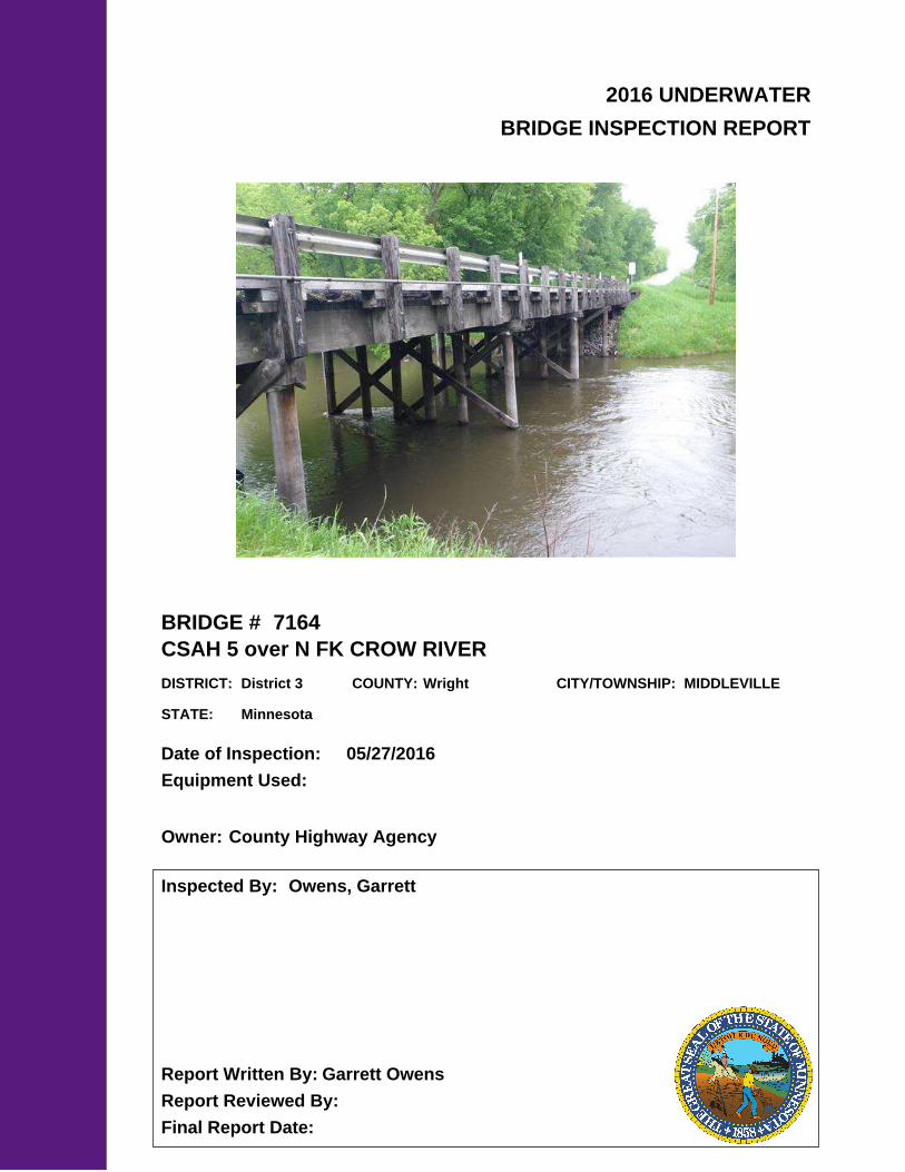
2016 UNDERWATER
BRIDGE INSPECTION REPORT
BRIDGE #
DISTRICT: COUNTY: CITY/TOWNSHIP:
Date of Inspection:
Equipment Used:
Inspected By:
Report Written By:
Report Reviewed By:
Final Report Date:
7164
CSAH 5 over N FK CROW RIVER
District 3 Wright MIDDLEVILLE
05/27/2016
Owens, Garrett
Garrett Owens
County Highway AgencyOwner:
MinnesotaSTATE:
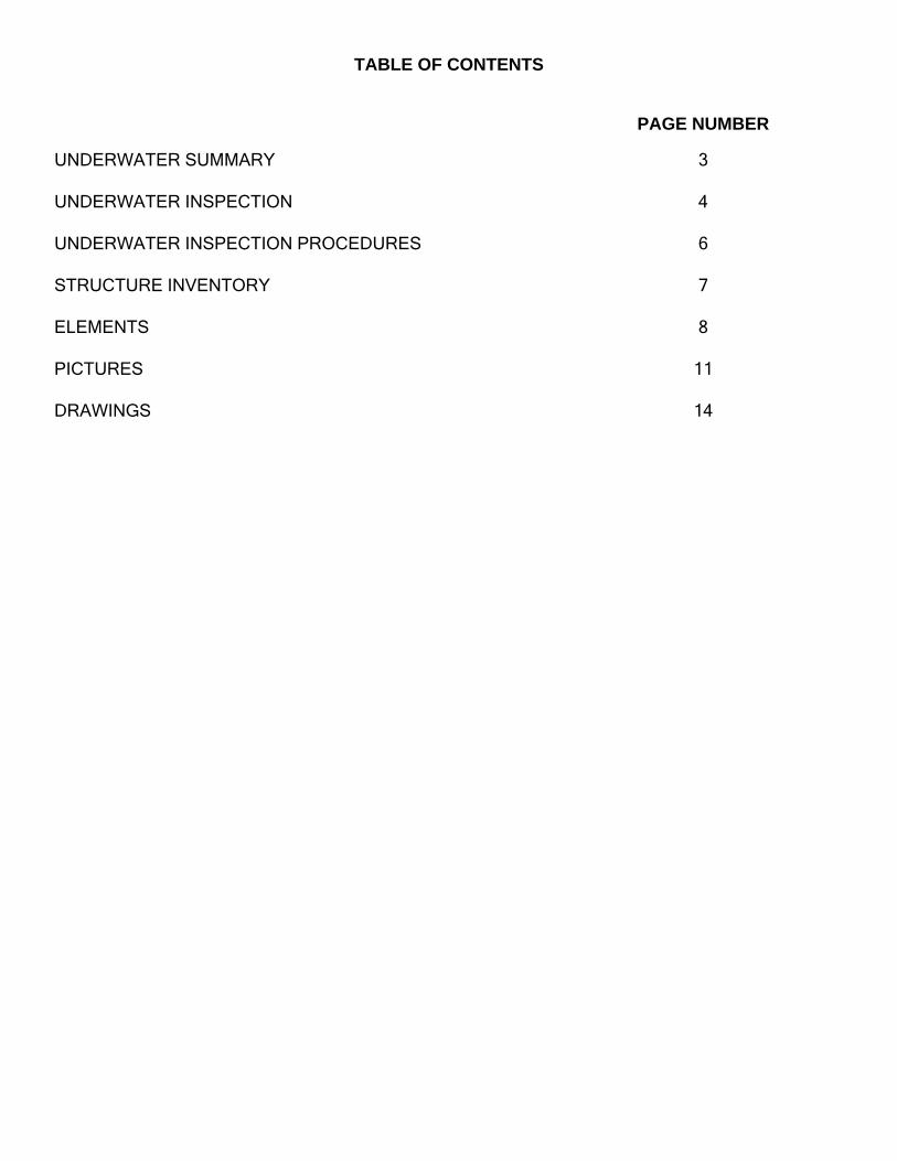
UNDERWATER SUMMARY 3
UNDERWATER INSPECTION 4
UNDERWATER INSPECTION PROCEDURES 6
STRUCTURE INVENTORY 7
ELEMENTS 8
PICTURES 11
DRAWINGS 14
TABLE OF CONTENTS
PAGE NUMBER
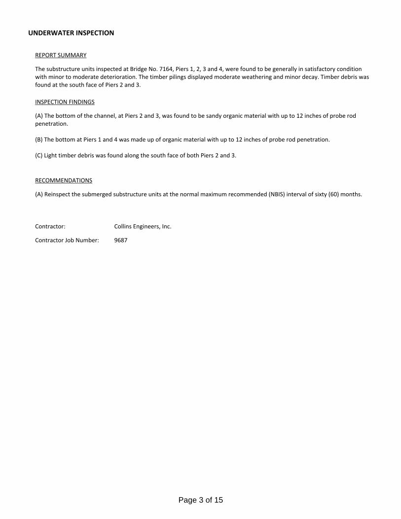
Contractor:
(A) Reinspect the submerged substructure units at the normal maximum recommended (NBIS) interval of sixty (60) months.
Collins Engineers, Inc.
9687Contractor Job Number:
RECOMMENDATIONS
REPORT SUMMARY
UNDERWATER INSPECTION
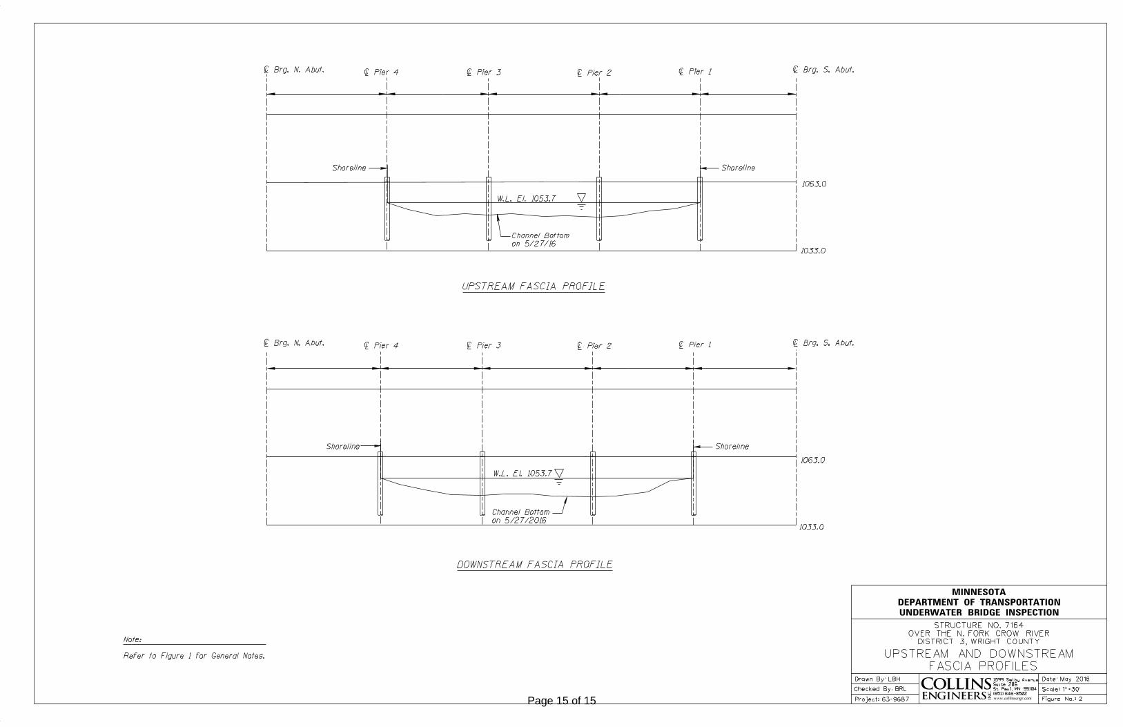
The substructure units inspected at Bridge No. 7164, Piers 1, 2, 3 and 4, were found to be generally in satisfactory condition with minor to moderate deterioration. The timber pilings displayed moderate weathering and minor decay. Timber debris was found at the south face of Piers 2 and 3.
(A) The bottom of the channel, at Piers 2 and 3, was found to be sandy organic material with up to 12 inches of probe rod penetration.
(B) The bottom at Piers 1 and 4 was made up of organic material with up to 12 inches of probe rod penetration.
(C) Light timber debris was found along the south face of both Piers 2 and 3.
INSPECTION FINDINGS
Page 3 of 15
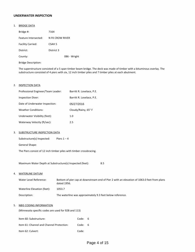
WATERLINE DATUM4.
8.5
Water Level Reference:
1053.7Waterline Elevation (feet):
Bottom of pier cap at downstream end of Pier 2 with an elevation of 1063.0 feet from plans dated 1956.
Substructure(s) Inspected:
SUBSTRUCTURE INSPECTION DATA3.
Piers 1 – 4
Maximum Water Depth at Substructure(s) Inspected (feet):
The Piers consist of 12 inch timber piles with timber crossbracing.
General Shape:
Code:Item 61: Channel and Channel Protection:
6
6
Code:Item 62: Culvert:
5.
The waterline was approximately 9.3 feet below reference.Description:
NBIS CODING INFORMATION
Code:Item 60: Substructure:
(Minnesota specific codes are used for 92B and 113)
2.5
District:
CSAH 5Facility Carried:
District 3
Bridge Description:
086 - WrightCounty:
BRIDGE DATA1.
UNDERWATER INSPECTION
Bridge #:
N FK CROW RIVERFeature Intersected:
7164
Weather Conditions:
05/27/2016Date of Underwater Inspection:
Cloudy/Rainy, 65° F
Waterway Velocity (ft/sec):
1.0Underwater Visibility (feet):
INSPECTION DATA2.
The superstructure consisted of a 5 span timber beam bridge. The deck was made of timber with a bituminous overlay. The substructure consisted of 4 piers with six, 12 inch timber piles and 7 timber piles at each abutment.
Professional Engineer/Team Leader:
Barritt R. Lovelace, P.E.Inspection Diver:
Barritt R. Lovelace, P.E.
Page 4 of 15
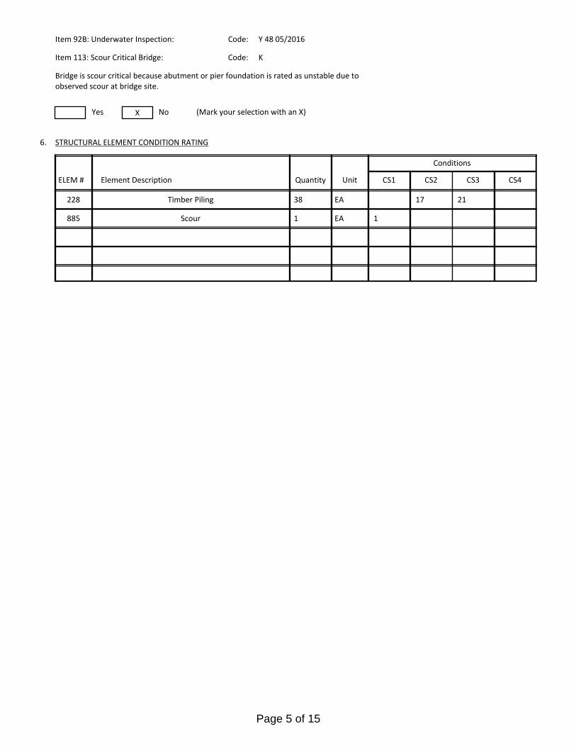
885
17 21
1EAScour 1
STRUCTURAL ELEMENT CONDITION RATING6.
No (Mark your selection with an X)
Item 113: Scour Critical Bridge: Code:
Y 48 05/2016 Item 92B: Underwater Inspection: Code:
Yes X
K
Bridge is scour critical because abutment or pier foundation is rated as unstable due to observed scour at bridge site.
CS4CS3CS1 CS2
EA38228 Timber Piling
Conditions
Quantity UnitElement DescriptionELEM #
Page 5 of 15
The routine underwater inspection of Bridge 7164 (County Road 5 over the North Fork of the Crow River) was completed on May 27, 2016. The underwater inspection was conducted from shore. The inspection was conducted by a team consisting of a PE-Diver with a valid MnDOT Team Leader certification, a backup diver and a dive tender. The inspection utilized commercial dive equipment and techniques (SSA and/or SCUBA) in accordance with OSHA regulations. Profiles were taken along the upstream and downstream faces of the bridge and around the periphery of substructure units to determine the presence, location and area of scour.
The bridge elements inspected consisted of four timber pile bent piers. According to the bridge inventory or design drawings, Piers 1-4 were founded on 12 inch timber piles. Inspection procedures followed FHWA guidance and the MnDOT Bridge and Structure Inspection Program Manual with channel bottom probing to search for foundations. The routine underwater inspection frequency is recommended to remain at a maximum of 60 months based on those findings and risk factors. Also, inspection procedures should continue to follow the above approach and standard guidance with 100% Level I and 10% Level II intensity efforts.
INSPECTION PROCEDURES
UNDERWATER INSPECTION
Page 6 of 15
Spec. Feat.Pier Foundation (Material/Type)
2 - TIMBERCantilever ID
+ W A T E R W A Y +Number of Spans Historic Status
4 - PILE BENT
UnderwaterCulvert Type 4 - PILE BENT
Pinned Asbly.
05/27/2016
Barrel Length
127.0 ft. Navigation Control
Waterway Opening (sf.) 1694Structure Length
ft. Year Painted 1977
0 - No nav. control on waterwayDeck Width (Out-to-Out) 26.0
+ P A I N T +
APPR: 0 TOTAL:5 - Not eligible
MAIN: 5
Main Span Length 25.0 ft.Drainage Area (sq. mi.)
B R I D G E D A T A +Main Span Detail
0 - SUBSTANDARD+ M I S C.
Appr. Span Type Structure Flared
GR Termini 0 - SUBSTANDARD
Appr. Guardrail
Main Span Type 7 - Timber Median Width On Bridge
ft. Bridge Railing 0 - SUBSTANDARD
0 - SUBSTANDARD
Main Span Design 01 - Beam Span
ft. GR Transition
Skew 0
Y/N Freq Date
Abutment Foundation (Material/Type)
2 - TIMBER Frac. Critical
D E P T H I N S P. +Appr. Span Design
0 - No flare+ I N
Appr. Span Detail Field Conn. ID
Parallel Structure N - No parallel structure
Pier Protection
0 - Not Required
Rating Date 07/26/20113046 sq. ft. Traffic
ft. 50B. Rt 0.00Sidewalk Width 50A. Lt 0.00
Roadway Area (Curb-to-Curb)
Posted Load 2 - Vehicle & Semi (Type R12-5)
PostingStructure Area (Out-to-Out) 3302 sq. ft.
40 DBL: 40VEH: 24 SEMI:
Rt 37 ARail Type Lt 37 C N - N/AN - N/A B N - N/A
N - Not Applicable Overweight Permit CodesCurb Height Lt
ft. Horizontal 1 - Object Markers
0.67 ft. Vertical0.67 ft. Rt
Wear Surf Install Year
sq. ft. Nav. Vert. Lift Bridge Clear. (ft.)
K - LIMITED RISK
Year 2006Primer Type MN Scour Code
Painted Area
Unsound Paint % Nav. Clr. (ft.)
!
Deck Material 8 - Wood or Timber 0.0Wear Surf Type 6 - Bituminous
Vert. 0.0 Horiz.
S I G N S +Operating Rating 2 - HS TRUCK
N - Not Applicable (no deck) + B R I D G E
Inventory Rating 2 - HS TRUCK 12.7
19.7Deck Rebars Install Year
Deck Rebars
Finish TypeWear Course/Fill Depth 0.66 ft.
0 - None
Design Load 2 - H 15
+ C A P A C I T Y R A T I N G S +Deck Membrane
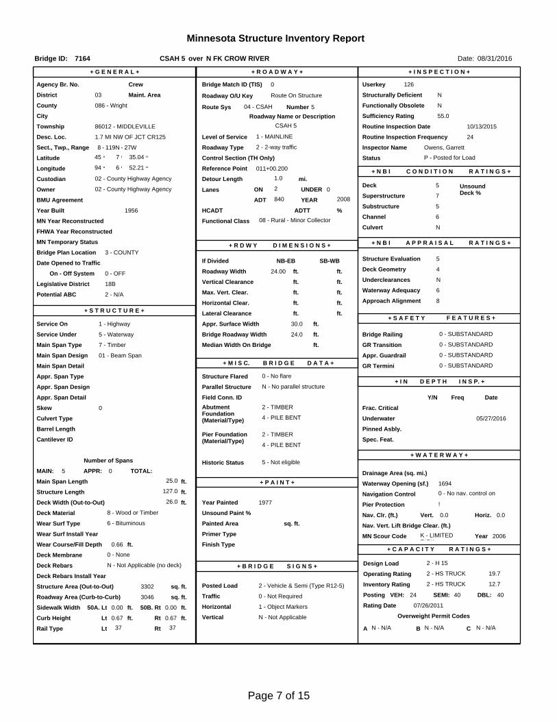
45 ° 7
Inspector Name Owens, Garrett
Latitude Control Section (TH Only) Status' 35.04 ''
2 - 2-way traffic
Routine Inspection Frequency 24
Sect., Twp., Range
1.7 MI NW OF JCT CR125 Level of Service 1 - MAINLINE
- 27W Roadway Type8 - 119N
Detour Length 1.0 mi.R A T I N G S +
Custodian 02 - County Highway Agency
Owner 02 - County Highway AgencyDeck 5 Unsound
Deck %
C O N D I T I O N° 6 '
P - Posted for Load
Longitude 94 011+00.200 + N B I 52.21 '' Reference Point
Crew
+ I N S P E C T I O N +
Agency Br. No. 126
District 03
Bridge Match ID (TIS) 0 Userkey
CSAH 5 over N FK CROW RIVER
Minnesota Structure Inventory Report
Bridge ID: 7164
+ G E N E R A L + + R O A D W A Y +
Date: 08/31/2016
Sufficiency Rating 55.0Roadway Name or Description
5
City
Routine Inspection Date 10/13/2015
Desc. Loc.
Township 86012 - MIDDLEVILLE CSAH 5
Number
NRoadway O/U Key Route On StructureMaint. Area Structurally Deficient
NRoute Sys 04 - CSAHCounty 086 - Wright Functionally Obsolete
Lanes
Waterway Adequacy 6Max. Vert. Clear.
ft.Legislative District 18Bft.Potential ABC 2 - N/A ft.
ft.On - Off System Roadway Width 24.00 ft.
Vertical Clearance ft.0 - OFF
Underclearances N
Service On 1 - Highway Appr. Surface Width+ S A F E T Y F E A T U R E S +
5 - Waterway Bridge Roadway Width 24.0
30.0 ft.
Service Under
ft.
ft. Approach Alignment 8Horizontal Clear.
ft.
ft.+ S T R U C T U R E + Lateral Clearance
HCADT ADTT5
Year Built 1956
MN Year Reconstructed Functional Class
%Channel 6
Substructure
0Superstructure 7
ON 2 UNDER
840 YEAR 2008BMU Agreement ADT
Structure Evaluation 5If Divided
D I M E N S I O N S +Bridge Plan Location 3 - COUNTY
Deck Geometry 4NB-EB SB-WBDate Opened to Traffic
+ R D W Y
FHWA Year Reconstructed
MN Temporary Status
08 - Rural - Minor CollectorCulvert N
A P P R A I S A L R A T I N G S ++ N B I
Page 7 of 15
County:
City:
Township:
Township:Section: Range:
Span Type:
NBI Deck: Super: Sub: Chan: Culv:
Appraisal Ratings - Approach: Waterway:
Required Bridge Signs - Load Posting:
Horizntal:
Traffic:
Vertical:
MN Scour Code:
Open, Posted, Closed:
Location:
Route:
Control Section:
Local Agency Bridge Nbr.:
Ref. Pt.:
Maint. Area:
Length:
Deck Width:
Rdwy. Area/ Pct. Unsnd:
Paint Area/ Pct. Unsnd:
Culvert:
Wright
86012 - MIDDLEVILLE
119N8 27W
7 - Wood or Timber 2 -Stringer/Multi-beam or Girder
5 7 5 6 N
8 6
2 - Vehicle & Semi (TypeR12-5)
1 - Object Markers
0 - Not Required
N - Not Applicable
K - LIMITED RISK
1.7 MI NW OF JCT CR125
04 - CSAH 5 011+00.200
127.0
26.0
3046 sq. ft. / %
sq. ft. / %
N/A
P - Posted for Load
ft.
ft.
Postings: 24 40 40List:
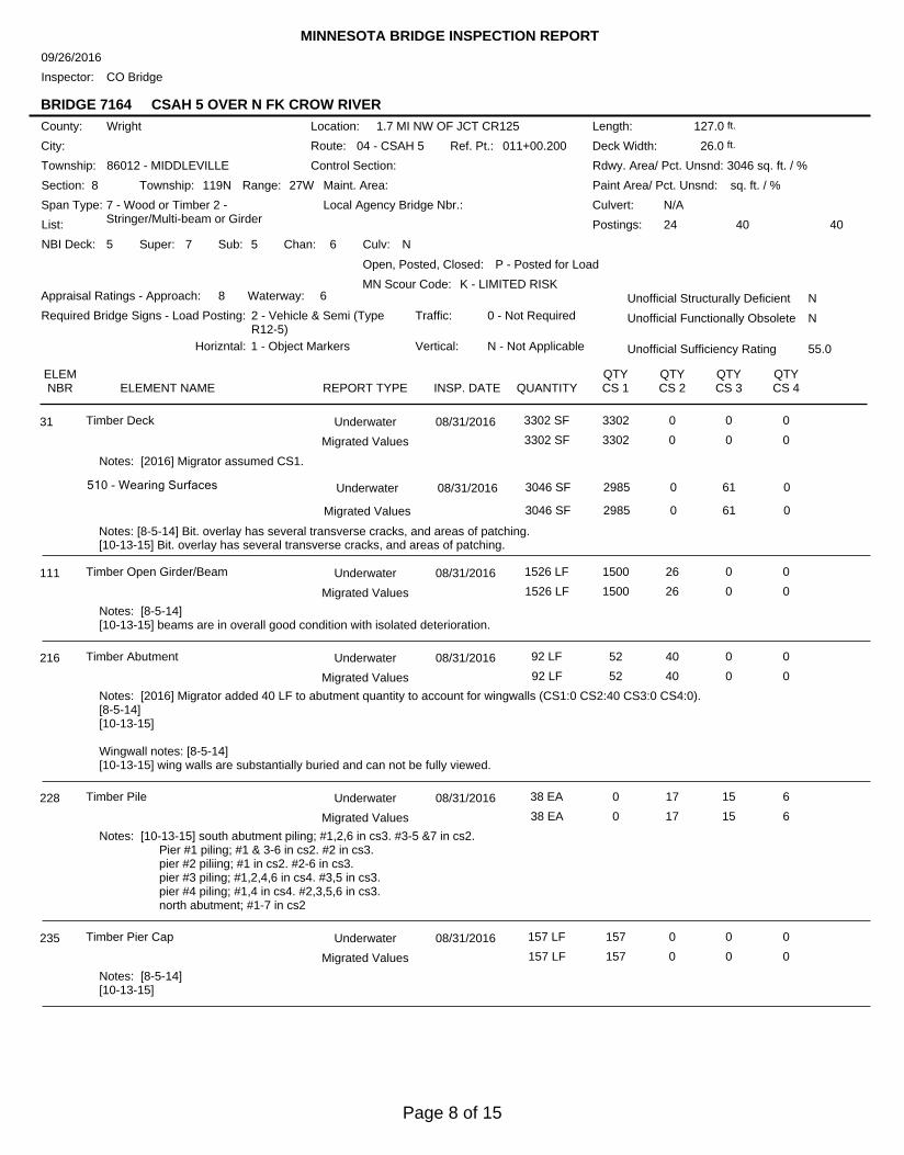
MINNESOTA BRIDGE INSPECTION REPORT
09/26/2016
Inspector: CO Bridge
BRIDGE 7164 CSAH 5 OVER N FK CROW RIVER
Unofficial Structurally Deficient N
NUnofficial Functionally Obsolete
Unofficial Sufficiency Rating 55.0
ELEMNBR ELEMENT NAME INSP. DATE QUANTITY
QTYCS 1
QTYCS 2
QTYCS 3
QTYCS 4REPORT TYPE
Timber Deck 08/31/2016 3302 SF 3302 0 0 031 Underwater
3302 SF 3302 0 0 0Migrated Values
Notes: [2016] Migrator assumed CS1.
510 - Wearing Surfaces 3046 SF 2985 0 61 0
Notes: [8-5-14] Bit. overlay has several transverse cracks, and areas of patching.[10-13-15] Bit. overlay has several transverse cracks, and areas of patching.
Underwater 08/31/2016
3046 SF 2985 0 61 0Migrated Values
Timber Open Girder/Beam 08/31/2016 1526 LF 1500 26 0 0111 Underwater
1526 LF 1500 26 0 0Migrated Values
Notes: [8-5-14][10-13-15] beams are in overall good condition with isolated deterioration.
Timber Abutment 08/31/2016 92 LF 52 40 0 0216 Underwater
92 LF 52 40 0 0Migrated Values
Notes: [2016] Migrator added 40 LF to abutment quantity to account for wingwalls (CS1:0 CS2:40 CS3:0 CS4:0).[8-5-14][10-13-15]
Wingwall notes: [8-5-14][10-13-15] wing walls are substantially buried and can not be fully viewed.
Timber Pile 08/31/2016 38 EA 0 17 15 6228 Underwater
38 EA 0 17 15 6Migrated Values
Notes: [10-13-15] south abutment piling; #1,2,6 in cs3. #3-5 &7 in cs2. Pier #1 piling; #1 & 3-6 in cs2. #2 in cs3. pier #2 piliing; #1 in cs2. #2-6 in cs3. pier #3 piling; #1,2,4,6 in cs4. #3,5 in cs3. pier #4 piling; #1,4 in cs4. #2,3,5,6 in cs3. north abutment; #1-7 in cs2
Timber Pier Cap 08/31/2016 157 LF 157 0 0 0235 Underwater
157 LF 157 0 0 0Migrated Values
Notes: [8-5-14][10-13-15]
Page 8 of 15
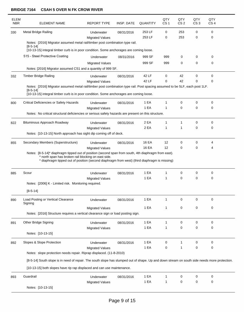
Metal Bridge Railing 08/31/2016 253 LF 0 253 0 0330 Underwater
253 LF 0 253 0 0Migrated Values
Notes: [2016] Migrator assumed metal rail/timber post combination type rail.[8-5-14][10-13-15] integral timber curb is in poor condition. Some anchorages are coming loose.
515 - Steel Protective Coating 999 SF 999 0 0 0
Notes: [2016] Migrator assumed CS1 and a quantity of 999 SF.
Underwater 08/31/2016
999 SF 999 0 0 0Migrated Values
Timber Bridge Railing 08/31/2016 42 LF 0 42 0 0332 Underwater
42 LF 0 42 0 0Migrated Values
Notes: [2016] Migrator assumed metal rail/timber post combination type rail. Post spacing assumed to be 5LF, each post 1LF.[8-5-14][10-13-15] integral timber curb is in poor condition. Some anchorages are coming loose.
Critical Deficiencies or Safety Hazards 08/31/2016 1 EA 1 0 0 0800 Underwater
1 EA 1 0 0 0Migrated Values
Notes: No critical structural deficiencies or serious safety hazards are present on this structure.
Bituminous Approach Roadway 08/31/2016 2 EA 1 1 0 0822 Underwater
2 EA 1 1 0 0Migrated Values
Notes: [10-13-15] North approach has sight dip coming off of deck.
Secondary Members (Superstructure) 08/31/2016 16 EA 12 0 0 4855 Underwater
16 EA 12 0 0 4Migrated Values
Notes: [8-5-14]* diaphragm tipped out of position (second span from south, 4th diaphragm from east). * north span has broken rail blocking on east side. * diaphragm tipped out of position (second diaphragm from west) (third diaphragm is missing)
Scour 08/31/2016 1 EA 1 0 0 0885 Underwater
1 EA 1 0 0 0Migrated Values
Notes: [2006] K - Limited risk. Monitoring required.
[8-5-14]
Load Posting or Vertical ClearanceSigning
08/31/2016 1 EA 1 0 0 0890 Underwater
1 EA 1 0 0 0Migrated Values
Notes: [2016] Structure requires a vertical clearance sign or load posting sign.
Other Bridge Signing 08/31/2016 1 EA 1 0 0 0891 Underwater
1 EA 1 0 0 0Migrated Values
Notes: [10-13-15]
Slopes & Slope Protection 08/31/2016 1 EA 0 1 0 0892 Underwater
1 EA 0 1 0 0Migrated Values
Notes: slope protection needs repair. Riprap displaced. (11-8-2010)
[8-5-14] South slope is in need of repair. The south slope has slumped out of shape. Up and down stream on south side needs more protection.
[10-13-15] both slopes have rip rap displaced and can use maintenance.
Guardrail 08/31/2016 1 EA 1 0 0 0893 Underwater
1 EA 1 0 0 0Migrated Values
Notes: [10-13-15]
ELEMNBR ELEMENT NAME INSP. DATE QUANTITY
QTYCS 1
QTYCS 2
QTYCS 3
QTYCS 4
BRIDGE 7164 CSAH 5 OVER N FK CROW RIVER
REPORT TYPE
Page 9 of 15
Deck & Approach Drainage 08/31/2016 1 EA 1 0 0 0894 Underwater
1 EA 1 0 0 0Migrated Values
Notes: [10-13-15]
Miscellaneous Items 08/31/2016 1 EA 1 0 0 0899 Underwater
1 EA 1 0 0 0Migrated Values
Notes: [10-13-15] conduit attached to east railing.
Protected Species 08/31/2016 1 EA 0 1 0 0900 Underwater
1 EA 0 1 0 0Migrated Values
Notes: [2016] Migrator determined the presence of swallows on this structure based on data in the inventory or comments in thegeneral/miscellaneous notes.
General Notes:
Inspector's Signature Reviewer's Signature
Inventory Notes:
Cracks & Splits in all timer elements. Most severe cracking located in pier columns. Drawing & pictures of locations in bridgefile. Inspector: Hans A. Engstrom PONTIS inspection comments - PONTIS inspection comments - Inspector William S.Augustin Certification BSI 1011
Insp. Mike MCcann BSI# 96130 and Nick Carlson. (2-4-2009)
Insp. Mike MCcann BSI# 96130 and Nick Carlson. (11-8-2010)
assistant inspector Brian Severson.[10-13-15]
58. Deck NBI:
36A. Brdg Railings NBI:
36B. Transitions NBI:
36C. Appr Guardrail NBI:
36D. Appr GuardrailTerminal NBI:
59. Superstructure NBI:
60. Substructure NBI:
61. Channel NBI:
62. Culvert NBI:
71. Waterway Adeq NBI:
72. Appr RoadwayAlignment NBI:
[8-5-14][10-13-15] Deck has several transverse and longitudinal cracks with areas of patching.
[8-5-14] Wood posts & steel beam rail.[10-13-15] Wood posts & steel beam rail.
[8-5-14][10-13-15] substandard railing connection, post spacing.
[8-5-14][10-13-15] Not long enough.
[8-5-14][10-13-15] turn down terminals.
[8-5-14][10-13-15]
[8-5-14][10-13-15] several piling with extensive weathering and splitting.
[8-5-14] South slope is slumping & protection needs repair.[10-13-15] Both slopes have rip rap displaced and need maintenance.
[8-5-14][10-13-15]
[8-5-14][10-13-15]
[8-5-14][10-13-15]
ELEMNBR ELEMENT NAME INSP. DATE QUANTITY
QTYCS 1
QTYCS 2
QTYCS 3
QTYCS 4
BRIDGE 7164 CSAH 5 OVER N FK CROW RIVER
REPORT TYPE
Page 10 of 15
Photo 1 - East Elevation, Looking Northwest
Photo 2 - West Elevation, Looking Southeast
Pictures
Page 11 of 15
Pictures
Photo 3 - View of North Shoreline and Pier 4, Looking Southeast
Photo 4 - View of Pier 3, Looking South
Page 12 of 15
Pictures
Photo 5 - View of Pier 2, Looking North
Photo 6 - View of South Shore and Pier 1, Looking North
Page 13 of 15

Page 14 of 15
Page 15 of 15