Embed Size (px)
Citation preview
2016 UNDERWATER
BRIDGE INSPECTION REPORT
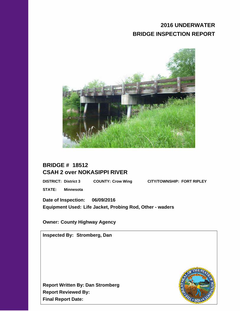
BRIDGE #
DISTRICT: COUNTY: CITY/TOWNSHIP:
Date of Inspection:
Equipment Used:
Inspected By:
Report Written By:
Report Reviewed By:
Final Report Date:
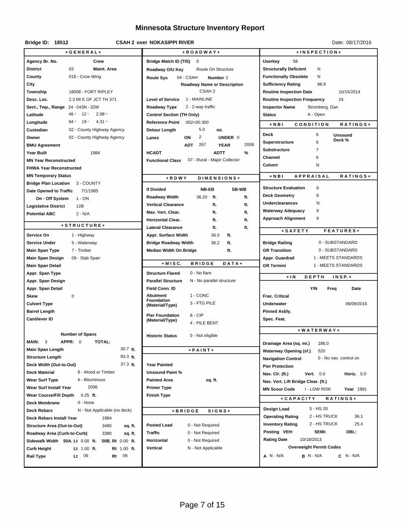
18512
CSAH 2 over NOKASIPPI RIVER
District 3 Crow Wing FORT RIPLEY
06/09/2016
Life Jacket, Probing Rod, Other - waders
Stromberg, Dan
Dan Stromberg
County Highway AgencyOwner:
MinnesotaSTATE:

UNDERWATER SUMMARY 3
UNDERWATER INSPECTION 4
UNDERWATER INSPECTION PROCEDURES 6
STRUCTURE INVENTORY 7
ELEMENTS 8
PHOTOGRAPHS 12
BRIDGE 18512 UNDERWATER INSPECTION DRAWINGS2016
14
TABLE OF CONTENTS
PAGE NUMBER
Contractor:
(A) Reinspect the submerged substructure units at the normal maximum recommended (NBIS) interval of sixty (60) months.
Collins Engineers, Inc.
9687Contractor Job Number:
RECOMMENDATIONS
REPORT SUMMARY
UNDERWATER INSPECTION
The substructure units inspected below water at Bridge No. 18512, Piers 1 and 2, were found to be in good to satisfactory condition with no defects of structural significance below water. The piles exhibited 25% to 50% coverage of surface corrosion, and rust nodules up to 1 inch diameter, with pitting up to 1/32 inch deep was present below water. The channel bottom around the substructure units appeared stable with no scour or other channel bottom deficiencies.
(A) From the channel bottom to 2 feet above the waterline 25% to 50% coverage of surface corrosion was present on all of the piles; below water rust nodules up to 1 inch in diameter and pitting up to 1/32 inch was also present.
(B) Riprap up to 1 foot in diameter was present at the abutments, however, the embankments at the structure were not well armored with only light riprap present on the east embankment.
(C) Minor erosion was present on both the upstream and downstream embankments with up to 3 foot vertical faces.
(D) The channel bottom material consisted of soft silt throughout with scattered riprap present around the middle of the piers allowing 2 feet of probe rod penetration.
(E) Light accumulations of timber debris with pieces up to 3 inches in diameter were present at the upstream and downstream piles of Pier 1 and the upstream pile of Pier 2.
INSPECTION FINDINGS
Page 3 of 15
The top of the pier cap at the downstream end of Pier 2.Water Level Reference:
WATERLINE DATUM
Waterline Elevation (feet):
The waterline was located approximately 11.0 feet below the reference.Description:
89.0 feet
4.
Piers 1 and 2Substructure(s) Inspected:
SUBSTRUCTURE INSPECTION DATA
General Shape:
3.0 feetMaximum Water Depth at Substructure(s) Inspected (feet):
Piers 1 and 2 consist of a single line of five cast-in-place concrete piles encased in steel shells supporting a reinforced concrete cap.
Code:Item 62: Culvert:
6
Y 48 06/2016Code:Item 92B: Underwater Inspection:
Code:
(Minnesota specific codes are used for 92B and 113)
NBIS CODING INFORMATION5.
Item 60: Substructure:
Item 61: Channel and Channel Protection:
7Code:
District 3District:
CSAH 2
County:
The superstructure consists of three spans of timber deck. The superstructure is supported by two reinforced concrete abutments and two pier bents with concrete piles encased in steel shells supporting a common concrete cap. The piers are numbered 1 and 2 starting from the west end of the bridge.
Bridge Description:
018 - Crow Wing
Facility Carried:
BRIDGE DATA1.
UNDERWATER INSPECTION
Bridge #:
NOKASIPPI RIVERFeature Intersected:
18512
Underwater Visibility (feet):
Partly Cloudy, 75°FWeather Conditions:
0.5 feet
3.
0.5 ft/secWaterway Velocity (ft/sec):
06/09/2016
Professional Engineer/Team Leader:
INSPECTION DATA2.
Daniel G. Stromberg
Date of Underwater Inspection:
Daniel G. StrombergInspection Diver:
Page 4 of 15

885 Scour 1 EA 1
STRUCTURAL ELEMENT CONDITION RATING
Conditions
6.
I
Bridge is scour critical because abutment or pier foundation is rated as unstable due to observed scour at bridge site.
Item 113: Scour Critical Bridge: Code:
No (Mark your selection with an X)Yes X
225
CS3 CS4
Steel or CIP Piling 1010 EA
CS2ELEM # Unit CS1Element Description Quantity
Page 5 of 15
The routine underwater inspection of Bridge 18512 (CSAH 2 over Nokasippi River) was completed on June 9, 2016. The underwater inspection was conducted from shore. The inspection was conducted by a team consisting of a Professional Engineer Diver with a valid MnDOT Team Leader certification, a backup diver and dive tender. Due to waterway conditions at the time of the inspection, the inspection could be accomplished by wading in accordance with OSHA regulations. Channel bottom profiles were taken along the upstream and downstream faces of the bridge and around the periphery of substructure units to determine the presence, location and area of scour.The bridge elements inspected consisted of two piers. According to the bridge inventory, Piers 1 and 2 are founded on cast-in-place concrete piles encased in steel shells supporting a reinforced concrete cap. Inspection procedures followed FHWA guidance and the MnDOT Bridge and Structure Inspection Program Manual with channel bottom probing to search for foundations. The maximum routine underwater inspection frequency is recommended to remain at 60 months based on those findings and risk factors. Also, inspection procedures should continue to follow the above approach and standard guidance with 100% Level I and 10% Level II intensity efforts.
INSPECTION PROCEDURES
UNDERWATER INSPECTION
Page 6 of 15
Spec. Feat.Pier Foundation (Material/Type)
8 - CIPCantilever ID
+ W A T E R W A Y +Number of Spans Historic Status
4 - PILE BENT
UnderwaterCulvert Type 3 - FTG PILE
Pinned Asbly.
06/09/2016
Barrel Length
93.3 ft. Navigation Control
Waterway Opening (sf.) 520Structure Length
ft. Year Painted
0 - No nav. control on waterwayDeck Width (Out-to-Out) 37.3
+ P A I N T +
APPR: 0 TOTAL:5 - Not eligible
MAIN: 3
Main Span Length 30.7 ft.Drainage Area (sq. mi.) 186.0
B R I D G E D A T A +Main Span Detail
1 - MEETS STANDARDS+ M I S C.
Appr. Span Type Structure Flared
GR Termini 1 - MEETS STANDARDS
Appr. Guardrail
Main Span Type 7 - Timber Median Width On Bridge
ft. Bridge Railing 0 - SUBSTANDARD
0 - SUBSTANDARD
Main Span Design 09 - Slab Span
ft. GR Transition
Skew 0
Y/N Freq Date
Abutment Foundation (Material/Type)
1 - CONC Frac. Critical
D E P T H I N S P. +Appr. Span Design
0 - No flare+ I N
Appr. Span Detail Field Conn. ID
Parallel Structure N - No parallel structure
Pier Protection
0 - Not Required
Rating Date 10/18/20133380 sq. ft. Traffic
ft. 50B. Rt 0.00Sidewalk Width 50A. Lt 0.00
Roadway Area (Curb-to-Curb)
Posted Load 0 - Not Required
PostingStructure Area (Out-to-Out) 3480 sq. ft.
DBL:VEH: SEMI:
Rt 06 ARail Type Lt 06 C N - N/AN - N/A B N - N/A
N - Not Applicable Overweight Permit CodesCurb Height Lt
ft. Horizontal 0 - Not Required
1.00 ft. Vertical1.00 ft. Rt
Wear Surf Install Year 2006
sq. ft. Nav. Vert. Lift Bridge Clear. (ft.)
I - LOW RISK Year 1991Primer Type MN Scour Code
Painted Area
Unsound Paint % Nav. Clr. (ft.)Deck Material 8 - Wood or Timber 0.0Wear Surf Type 6 - Bituminous
Vert. 0.0 Horiz.
S I G N S +Operating Rating 2 - HS TRUCK
N - Not Applicable (no deck) + B R I D G E
Inventory Rating 2 - HS TRUCK 25.4
36.1Deck Rebars Install Year 1984
Deck Rebars
Finish TypeWear Course/Fill Depth 0.25 ft.
0 - None
Design Load 5 - HS 20
+ C A P A C I T Y R A T I N G S +Deck Membrane
46 ° 12
Inspector Name Stromberg, Dan
Latitude Control Section (TH Only) Status' 2.08 ''
2 - 2-way traffic
Routine Inspection Frequency 24
Sect., Twp., Range
2.3 MI E OF JCT TH 371 Level of Service 1 - MAINLINE
- 32W Roadway Type24 - 043N
Detour Length 5.0 mi.R A T I N G S +
Custodian 02 - County Highway Agency
Owner 02 - County Highway AgencyDeck 6 Unsound
Deck %
C O N D I T I O N° 19 '
A - Open
Longitude 94 002+00.300 + N B I 4.31 '' Reference Point
Crew
+ I N S P E C T I O N +
Agency Br. No. 58
District 03
Bridge Match ID (TIS) 0 Userkey
CSAH 2 over NOKASIPPI RIVER
Minnesota Structure Inventory Report
Bridge ID: 18512
+ G E N E R A L + + R O A D W A Y +
Date: 08/17/2016
Sufficiency Rating 98.9Roadway Name or Description
2
City
Routine Inspection Date 10/15/2014
Desc. Loc.
Township 18008 - FORT RIPLEY CSAH 2
Number
NRoadway O/U Key Route On StructureMaint. Area Structurally Deficient
NRoute Sys 04 - CSAHCounty 018 - Crow Wing Functionally Obsolete
Lanes
Waterway Adequacy 9Max. Vert. Clear.
ft.Legislative District 12Bft.Potential ABC 2 - N/A ft.
ft.On - Off System Roadway Width 36.20 ft.
Vertical Clearance ft.1 - ON
Underclearances N
Service On 1 - Highway Appr. Surface Width+ S A F E T Y F E A T U R E S +
5 - Waterway Bridge Roadway Width 36.2
36.0 ft.
Service Under
ft.
ft. Approach Alignment 9Horizontal Clear.
ft.
ft.+ S T R U C T U R E + Lateral Clearance
HCADT ADTT7
Year Built 1984
MN Year Reconstructed Functional Class
%Channel 6
Substructure
0Superstructure 6
ON 2 UNDER
267 YEAR 2008BMU Agreement ADT
Structure Evaluation 6If Divided
D I M E N S I O N S +Bridge Plan Location 3 - COUNTY
7/1/1985Deck Geometry 8
NB-EB SB-WBDate Opened to Traffic
+ R D W Y
FHWA Year Reconstructed
MN Temporary Status
07 - Rural - Major CollectorCulvert N
A P P R A I S A L R A T I N G S ++ N B I
Page 7 of 15
County:
City:
Township:
Township:Section: Range:
Span Type:
NBI Deck: Super: Sub: Chan: Culv:
Appraisal Ratings - Approach: Waterway:
Required Bridge Signs - Load Posting:
Horizntal:
Traffic:
Vertical:
MN Scour Code:
Open, Posted, Closed:
Location:
Route:
Control Section:
Local Agency Bridge Nbr.:
Ref. Pt.:
Maint. Area:
Length:
Deck Width:
Rdwy. Area/ Pct. Unsnd:
Paint Area/ Pct. Unsnd:
Culvert:
Crow Wing
18008 - FORT RIPLEY
043N24 32W
7 - Wood or Timber 1 - Slab
6 6 7 6 N
9 9
0 - Not Required
0 - Not Required
0 - Not Required
N - Not Applicable
I - LOW RISK
2.3 MI E OF JCT TH 371
04 - CSAH 2 002+00.300
93.3
37.3
3380 sq. ft. / %
sq. ft. / %
N/A
A - Open
ft.
ft.
Postings:List:
MINNESOTA BRIDGE INSPECTION REPORT
09/23/2016
Inspector: CO Bridge
BRIDGE 18512 CSAH 2 OVER NOKASIPPI RIVER
Unofficial Structurally Deficient N
NUnofficial Functionally Obsolete
Unofficial Sufficiency Rating 98.9
ELEMNBR ELEMENT NAME INSP. DATE QUANTITY
QTYCS 1
QTYCS 2
QTYCS 3
QTYCS 4REPORT TYPE
Timber Slab 08/17/2016 3480 SF 3480 0 0 054 Underwater
3480 SF 3480 0 0 0Migrated Values
Notes: [2016] Migrator assumed CS1.
510 - Wearing Surfaces 3380 SF 3312 0 68 0
Notes: 10/15/14: There are new unsealed cracks present over the piers 2-3 feet in diameter potholes pending along side the pier joints. Thereare some longitudinal crack in the wheel paths throughout. Gaps of 1/4" or less found in isolated areas of the panels between the laminatesdirectly below the longitudinal cracks in the bituminous above.10/26/12: Some longitudinal cracks showing up in the wheel paths of the center span and the west span. All cracks have been sealed. Gapsof 1/4" or less found in isolated areas of the panels between the laminates directly below the longitudinal cracks in the bituminous above.09/23/08: AC was replaced in 2006. Rides good. One longitudinal crack in the center span.11/13/06: Old AC remover & New AC placed in kind in summer 2006.09/24/04: AC OVERLAY HAS FLEXURE CRACKS LONGITUDINALLY AND TRANSVERSELY WITH LARGE CRACKS OVER THE PIERS.BRIDGE IS IN NEED OF A NEW BITUMINOUS OVERLAY. WATER IS COMING THROUGH THE DECKING EVERY 6 TO 8 FEET. ACOVERLAY HAS CRACKS LONGITUDINALLY AND TRANSVERSELY WITH LARGE CRACKS OVER PIERS. BRIDGE IS IN NEED OF ANEW OVERLAY. WATER IS ENTERING DECKING EVERY 6 TO 8 FEET.[2000] Numerous cracks in overlay
Underwater 08/17/2016
3380 SF 3312 0 68 0Migrated Values
Timber Floor Beam 08/17/2016 226 LF 152 74 0 0156 Underwater
226 LF 152 74 0 0Migrated Values
Notes: 10/15/14 - 10/26/12: Center span stiffener beam needs to be tightened.10/12/10: Center span stiffener beam needs to be tightened.
Reinforced Concrete Abutment 08/17/2016 115 LF 115 0 0 0215 Underwater
115 LF 115 0 0 0Migrated Values
Notes: [2016] Migrator added 40 LF to abutment quantity to account for wingwalls (CS1:40 CS2:0 CS3:0 CS4:0).
Wingwall notes:
Steel Pile 08/17/2016 10 EA 0 10 0 0225 Underwater
10 EA 0 10 0 0Migrated Values
Notes: 10/15/14 - 10/26/12: There is a 25% paint failure over all on all of the piles. There is heavy staining and minor rusting on the lower 3 to4 feet of all the piles. There is no significant section loss of the steel shell occurring at this time.10/12/10: There is a 25% paint failure over all on all of the piles. There is heavy staining and minor rusting on the lower 3 to 4 feet of all thepiles. There is no significant section loss of the steel shell occurring at this time.09/23/08: Less then 2% paint failure. No significant section loss is occurring. Heavy staining on the lower 4'.[2000] Need paint
515 - Steel Protective Coating 999 SF 999 0 0 0
Notes: [2016] Migrator assumed CS1 and a quantity of 999 SF.
Underwater 08/17/2016
999 SF 999 0 0 0Migrated Values
Page 8 of 15
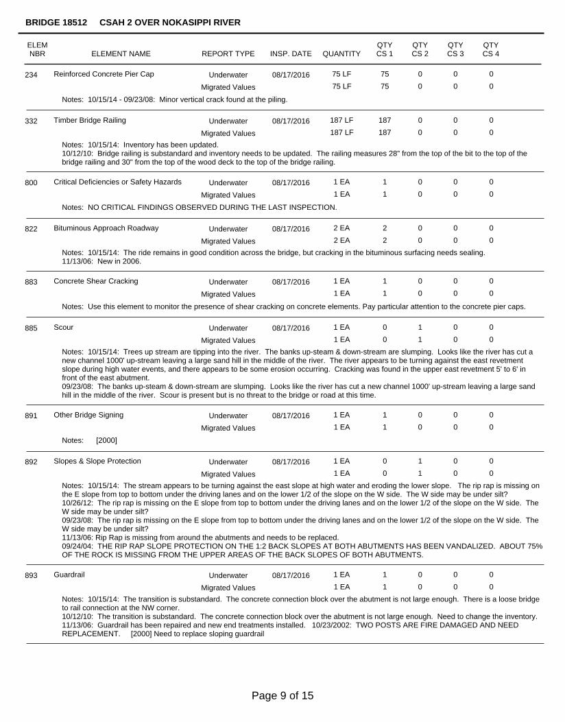
Reinforced Concrete Pier Cap 08/17/2016 75 LF 75 0 0 0234 Underwater
75 LF 75 0 0 0Migrated Values
Notes: 10/15/14 - 09/23/08: Minor vertical crack found at the piling.
Timber Bridge Railing 08/17/2016 187 LF 187 0 0 0332 Underwater
187 LF 187 0 0 0Migrated Values
Notes: 10/15/14: Inventory has been updated.10/12/10: Bridge railing is substandard and inventory needs to be updated. The railing measures 28" from the top of the bit to the top of thebridge railing and 30" from the top of the wood deck to the top of the bridge railing.
Critical Deficiencies or Safety Hazards 08/17/2016 1 EA 1 0 0 0800 Underwater
1 EA 1 0 0 0Migrated Values
Notes: NO CRITICAL FINDINGS OBSERVED DURING THE LAST INSPECTION.
Bituminous Approach Roadway 08/17/2016 2 EA 2 0 0 0822 Underwater
2 EA 2 0 0 0Migrated Values
Notes: 10/15/14: The ride remains in good condition across the bridge, but cracking in the bituminous surfacing needs sealing.11/13/06: New in 2006.
Concrete Shear Cracking 08/17/2016 1 EA 1 0 0 0883 Underwater
1 EA 1 0 0 0Migrated Values
Notes: Use this element to monitor the presence of shear cracking on concrete elements. Pay particular attention to the concrete pier caps.
Scour 08/17/2016 1 EA 0 1 0 0885 Underwater
1 EA 0 1 0 0Migrated Values
Notes: 10/15/14: Trees up stream are tipping into the river. The banks up-steam & down-stream are slumping. Looks like the river has cut anew channel 1000' up-stream leaving a large sand hill in the middle of the river. The river appears to be turning against the east revetmentslope during high water events, and there appears to be some erosion occurring. Cracking was found in the upper east revetment 5' to 6' infront of the east abutment.09/23/08: The banks up-steam & down-stream are slumping. Looks like the river has cut a new channel 1000' up-stream leaving a large sandhill in the middle of the river. Scour is present but is no threat to the bridge or road at this time.
Other Bridge Signing 08/17/2016 1 EA 1 0 0 0891 Underwater
1 EA 1 0 0 0Migrated Values
Notes: [2000]
Slopes & Slope Protection 08/17/2016 1 EA 0 1 0 0892 Underwater
1 EA 0 1 0 0Migrated Values
Notes: 10/15/14: The stream appears to be turning against the east slope at high water and eroding the lower slope. The rip rap is missing onthe E slope from top to bottom under the driving lanes and on the lower 1/2 of the slope on the W side. The W side may be under silt?10/26/12: The rip rap is missing on the E slope from top to bottom under the driving lanes and on the lower 1/2 of the slope on the W side. TheW side may be under silt?09/23/08: The rip rap is missing on the E slope from top to bottom under the driving lanes and on the lower 1/2 of the slope on the W side. TheW side may be under silt?11/13/06: Rip Rap is missing from around the abutments and needs to be replaced.09/24/04: THE RIP RAP SLOPE PROTECTION ON THE 1:2 BACK SLOPES AT BOTH ABUTMENTS HAS BEEN VANDALIZED. ABOUT 75%OF THE ROCK IS MISSING FROM THE UPPER AREAS OF THE BACK SLOPES OF BOTH ABUTMENTS.
Guardrail 08/17/2016 1 EA 1 0 0 0893 Underwater
1 EA 1 0 0 0Migrated Values
Notes: 10/15/14: The transition is substandard. The concrete connection block over the abutment is not large enough. There is a loose bridgeto rail connection at the NW corner.10/12/10: The transition is substandard. The concrete connection block over the abutment is not large enough. Need to change the inventory.11/13/06: Guardrail has been repaired and new end treatments installed. 10/23/2002: TWO POSTS ARE FIRE DAMAGED AND NEEDREPLACEMENT. [2000] Need to replace sloping guardrail
ELEMNBR ELEMENT NAME INSP. DATE QUANTITY
QTYCS 1
QTYCS 2
QTYCS 3
QTYCS 4
BRIDGE 18512 CSAH 2 OVER NOKASIPPI RIVER
REPORT TYPE
Page 9 of 15
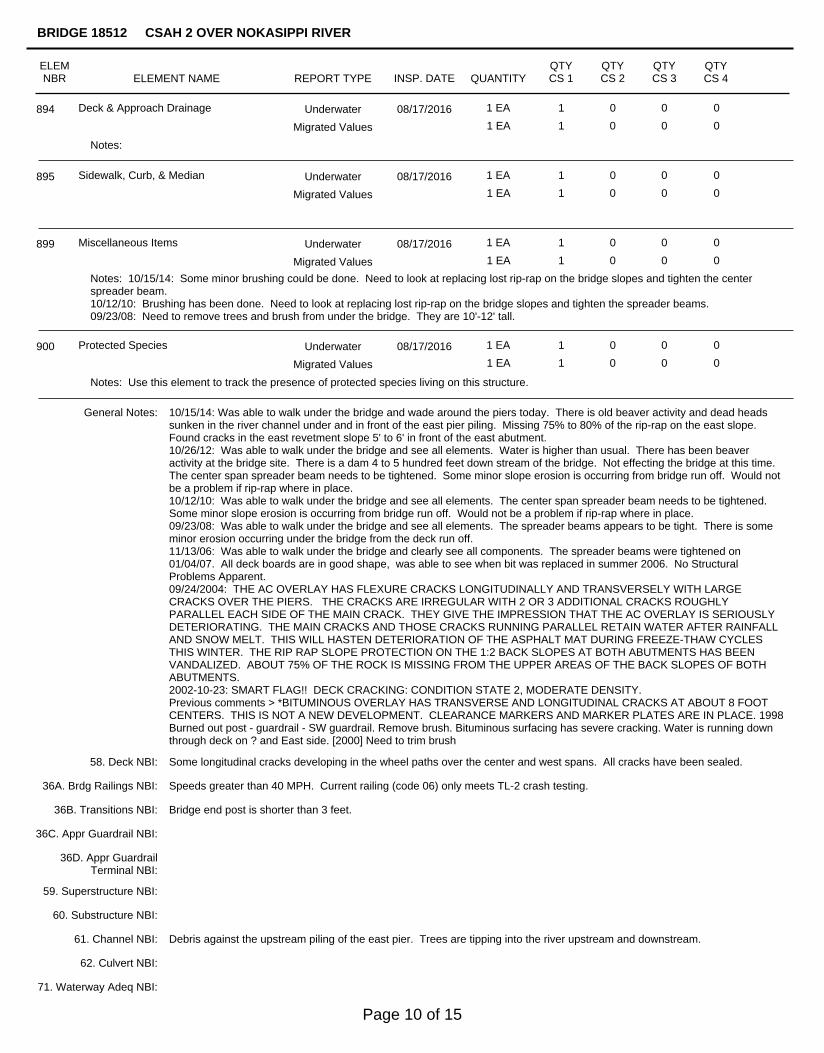
Deck & Approach Drainage 08/17/2016 1 EA 1 0 0 0894 Underwater
1 EA 1 0 0 0Migrated Values
Notes:
Sidewalk, Curb, & Median 08/17/2016 1 EA 1 0 0 0895 Underwater
1 EA 1 0 0 0Migrated Values
Miscellaneous Items 08/17/2016 1 EA 1 0 0 0899 Underwater
1 EA 1 0 0 0Migrated Values
Notes: 10/15/14: Some minor brushing could be done. Need to look at replacing lost rip-rap on the bridge slopes and tighten the centerspreader beam.10/12/10: Brushing has been done. Need to look at replacing lost rip-rap on the bridge slopes and tighten the spreader beams.09/23/08: Need to remove trees and brush from under the bridge. They are 10'-12' tall.
Protected Species 08/17/2016 1 EA 1 0 0 0900 Underwater
1 EA 1 0 0 0Migrated Values
Notes: Use this element to track the presence of protected species living on this structure.
General Notes: 10/15/14: Was able to walk under the bridge and wade around the piers today. There is old beaver activity and dead headssunken in the river channel under and in front of the east pier piling. Missing 75% to 80% of the rip-rap on the east slope.Found cracks in the east revetment slope 5' to 6' in front of the east abutment.10/26/12: Was able to walk under the bridge and see all elements. Water is higher than usual. There has been beaveractivity at the bridge site. There is a dam 4 to 5 hundred feet down stream of the bridge. Not effecting the bridge at this time.The center span spreader beam needs to be tightened. Some minor slope erosion is occurring from bridge run off. Would notbe a problem if rip-rap where in place.10/12/10: Was able to walk under the bridge and see all elements. The center span spreader beam needs to be tightened.Some minor slope erosion is occurring from bridge run off. Would not be a problem if rip-rap where in place.09/23/08: Was able to walk under the bridge and see all elements. The spreader beams appears to be tight. There is someminor erosion occurring under the bridge from the deck run off.11/13/06: Was able to walk under the bridge and clearly see all components. The spreader beams were tightened on01/04/07. All deck boards are in good shape, was able to see when bit was replaced in summer 2006. No StructuralProblems Apparent.09/24/2004: THE AC OVERLAY HAS FLEXURE CRACKS LONGITUDINALLY AND TRANSVERSELY WITH LARGECRACKS OVER THE PIERS. THE CRACKS ARE IRREGULAR WITH 2 OR 3 ADDITIONAL CRACKS ROUGHLYPARALLEL EACH SIDE OF THE MAIN CRACK. THEY GIVE THE IMPRESSION THAT THE AC OVERLAY IS SERIOUSLYDETERIORATING. THE MAIN CRACKS AND THOSE CRACKS RUNNING PARALLEL RETAIN WATER AFTER RAINFALLAND SNOW MELT. THIS WILL HASTEN DETERIORATION OF THE ASPHALT MAT DURING FREEZE-THAW CYCLESTHIS WINTER. THE RIP RAP SLOPE PROTECTION ON THE 1:2 BACK SLOPES AT BOTH ABUTMENTS HAS BEENVANDALIZED. ABOUT 75% OF THE ROCK IS MISSING FROM THE UPPER AREAS OF THE BACK SLOPES OF BOTHABUTMENTS.2002-10-23: SMART FLAG!! DECK CRACKING: CONDITION STATE 2, MODERATE DENSITY.Previous comments > *BITUMINOUS OVERLAY HAS TRANSVERSE AND LONGITUDINAL CRACKS AT ABOUT 8 FOOTCENTERS. THIS IS NOT A NEW DEVELOPMENT. CLEARANCE MARKERS AND MARKER PLATES ARE IN PLACE. 1998Burned out post - guardrail - SW guardrail. Remove brush. Bituminous surfacing has severe cracking. Water is running downthrough deck on ? and East side. [2000] Need to trim brush
58. Deck NBI:
36A. Brdg Railings NBI:
36B. Transitions NBI:
36C. Appr Guardrail NBI:
36D. Appr GuardrailTerminal NBI:
59. Superstructure NBI:
60. Substructure NBI:
61. Channel NBI:
62. Culvert NBI:
71. Waterway Adeq NBI:
72. Appr RoadwayAlignment NBI:
Some longitudinal cracks developing in the wheel paths over the center and west spans. All cracks have been sealed.
Speeds greater than 40 MPH. Current railing (code 06) only meets TL-2 crash testing.
Bridge end post is shorter than 3 feet.
Debris against the upstream piling of the east pier. Trees are tipping into the river upstream and downstream.
ELEMNBR ELEMENT NAME INSP. DATE QUANTITY
QTYCS 1
QTYCS 2
QTYCS 3
QTYCS 4
BRIDGE 18512 CSAH 2 OVER NOKASIPPI RIVER
REPORT TYPE
Page 10 of 15
ELEMNBR ELEMENT NAME INSP. DATE QUANTITY
QTYCS 1
QTYCS 2
QTYCS 3
QTYCS 4
BRIDGE 18512 CSAH 2 OVER NOKASIPPI RIVER
REPORT TYPE
Inspector's Signature Reviewer's Signature
Inventory Notes:
72. Appr RoadwayAlignment NBI:
Page 11 of 15
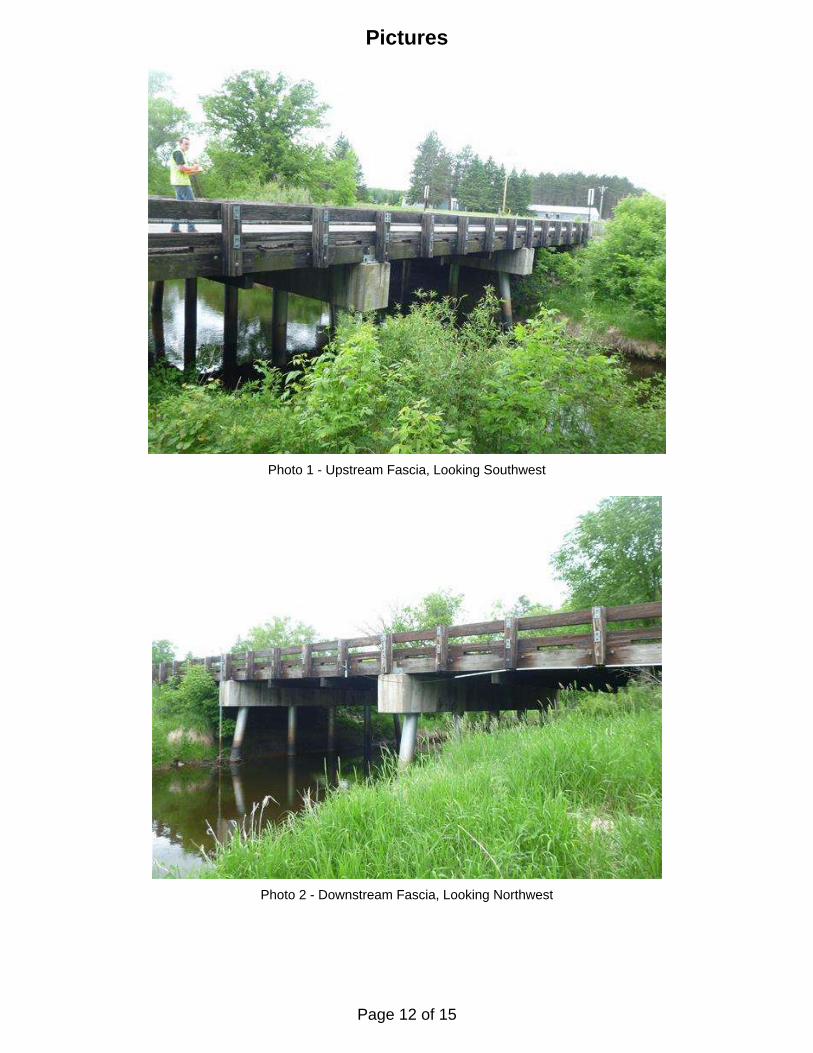
Photo 1 - Upstream Fascia, Looking Southwest
Photo 2 - Downstream Fascia, Looking Northwest
Pictures
Page 12 of 15
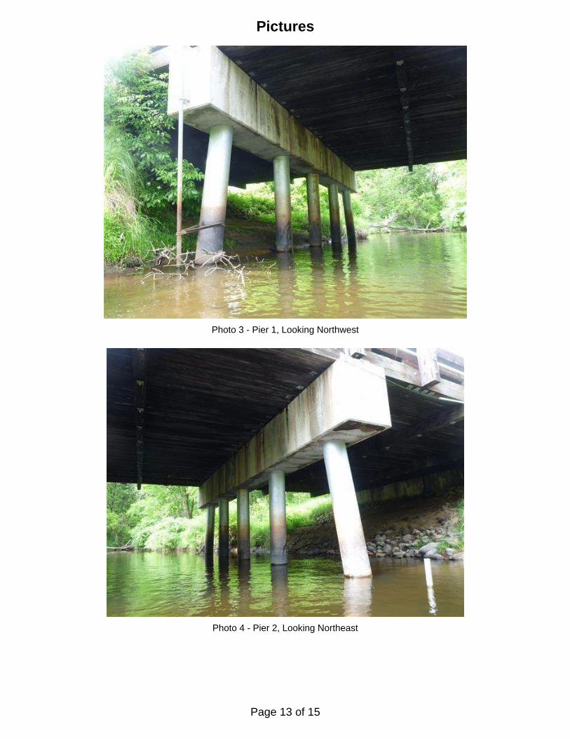
Pictures
Photo 3 - Pier 1, Looking Northwest
Photo 4 - Pier 2, Looking Northeast
Page 13 of 15
Legend
SOUNDING PLAN
UNDERWATER BRIDGE INSPECTION
DEPARTMENT OF TRANSPORTATION
MINNESOTA
INSPECTION AND SOUNDING PLAN
Flo
w
Cast-In-Place Concrete Pile
TYPICAL END VIEW OF PIER
Pier 1
Timber Debris
Sounding Depth (6/9/16)
CHECKED BY: DGS
123 North Wacker Drive
Suite 900
Chicago, Il. 60606
(312) 704-9300
www.collinsengr.com
DRAWN BY: ELN
Code: 968718512
1
DATE: JUNE 9, 2016
SCALE: NTS
FIGURE NO.: 1
DISTRICT 3, CROW WING COUNTY
OVER NOKASIPPI RIVER
STRUCTURE NO. 18512
(Typ.)
Shoreline
-1.2
29'-10•" 30'-9" 29'-10•"
N
West Abutment East Abutment
Pier 2
-4.0 -3.9 -3.4 -2.2
-1.5 -4.0-4.2 -3.2 -2.2
-1.0 -3.0 -1.5
River
Nokasip
pi
-2.2
Battered Pile
Cast-In-Place Concrete
2
2
2
Pier 2.
present at the upstream and downstream piles of Pier 1 and the upstream pile of
Light accumulations of timber debris with pieces up to 3 inches in diameter were2
present around the middle of the piers allowing 2 feet of probe rod penetration.
The channel bottom material consisted of soft silt throughout with scattered riprap 1
INSPECTION NOTES:
units.
7. Soundings were taken parallel to the bridge at 1/4 point intervals between the substructure
6. Soundings indicate the water depth at the time of inspection and are measured in feet.
and pitting up to 1/32 inch was also present.
corrosion was present on all of the piles; below water rust nodules up to 1 inch in diameter
From the channel bottom to 2 feet above the waterline 25% to 50% coverage of surface 5.
to 3 foot vertical faces.
Minor erosion was present on both the upstream and downstream embankments with up 4.
the structure were not well armored with only light riprap present on the east embankment.
Riprap up to 1 foot in diameter was present at the abutments, however, the embankments at3.
Based on the assumed reference the waterline elevation was 89.0.
bridge elevation information was available, a reference elevation of 100.0 was assumed.
11.0 feet below the top of pier cap at downstream end of Pier 2. Since insufficient
At the time of inspection on June 9, 2016, the waterline was located approximately2.
1. Pier 1 and 2 were inspected underwater.
GENERAL NOTES:
Page 14 of 15
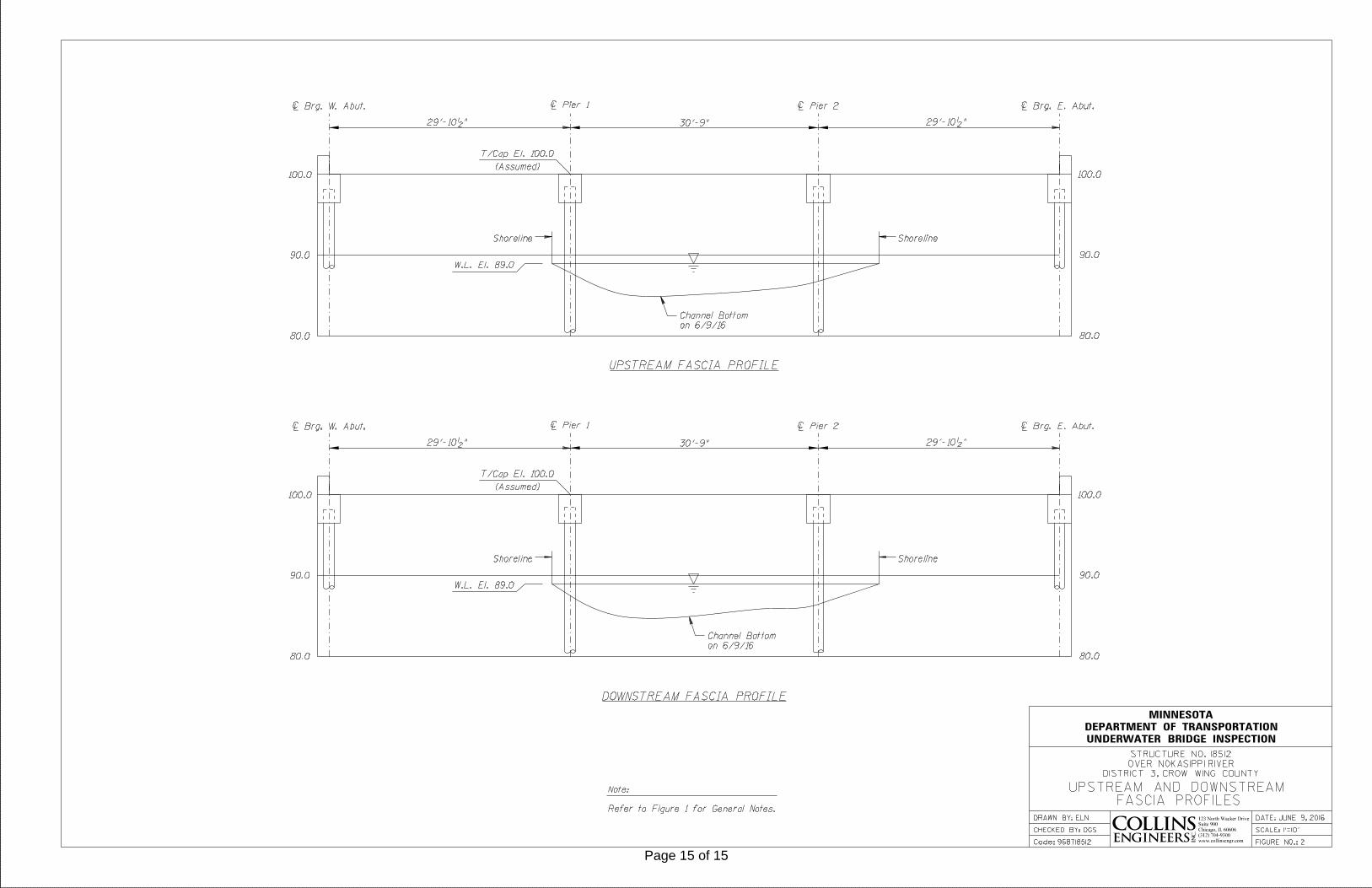
UNDERWATER BRIDGE INSPECTION
DEPARTMENT OF TRANSPORTATION
MINNESOTA
UPSTREAM AND DOWNSTREAMFASCIA PROFILES
UPSTREAM FASCIA PROFILE
DOWNSTREAM FASCIA PROFILE
~ Pier 1
Shoreline
on 6/9/16
Channel Bottom
123 North Wacker Drive
Suite 900
Chicago, Il. 60606
(312) 704-9300
www.collinsengr.com
DRAWN BY: ELN
CHECKED BY: DGS
Code: 968718512
DISTRICT 3, CROW WING COUNTY
OVER NOKASIPPI RIVER
STRUCTURE NO. 18512
DATE: JUNE 9, 2016
SCALE: 1"=10'
FIGURE NO.: 2
29'-10•" 30'-9" 29'-10•"
~ Brg. W. Abut. ~ Pier 2 ~ Brg. E. Abut.
(Assumed)
T/Cap El. 100.0
Shoreline
100.0
90.0
80.0
100.0
90.0
80.0
W.L. El. 89.0
~ Pier 1
Shoreline
29'-10•" 30'-9" 29'-10•"
~ Brg. W. Abut. ~ Pier 2 ~ Brg. E. Abut.
(Assumed)
T/Cap El. 100.0
Shoreline
100.0
90.0
80.0
100.0
90.0
80.0
W.L. El. 89.0
Refer to Figure 1 for General Notes.
Note:
on 6/9/16
Channel Bottom
Page 15 of 15