Embed Size (px)
Citation preview

Initial Study San Jose/Santa Clara Water Pollution Control Plant NNoorr tteecchh//ZZaannkkeerr SSeerr vviiccee LLaatteerr aall File No. PP11-054 January 2012
TABLE OF CONTENTS
Page
Nortech/Zanker Service Lateral i Initial Study City of San José January 2012
SECTION 1.0 INTRODUCTION AND PURPOSE ........................................................................... 1 SECTION 2.0 PROJECT INFORMATION ........................................................................................ 2
2.1 PROJECT TITLE ............................................................................................ 2 2.2 PROJECT LOCATION ................................................................................... 2 2.3 LEAD AGENCY CONTACT ......................................................................... 2 2.4 PROJECT PROPONENT ................................................................................ 2 2.5 ASSESSOR’S PARCEL NUMBERS ............................................................. 2 2.6 ZONING DISTRICT AND GENERAL PLAN DESIGNATIONS ................ 2
SECTION 3.0 PROJECT DESCRIPTION .......................................................................................... 7
3.1 BACKGROUND ............................................................................................. 7 3.2 PROJECT DESCRIPTION ............................................................................. 8
SECTION 4.0 ENVIRONMENTAL CHECKLIST AND DISCUSSION OF IMPACTS ................ 12
4.1 AESTHETICS ............................................................................................... 12 4.2 AGRICULTURAL AND FOREST RESOURCES ....................................... 19 4.3 AIR QUALITY ............................................................................................. 21 4.4 BIOLOGICAL RESOURCES ....................................................................... 24 4.5 CULTURAL RESOURCES .......................................................................... 34 4.6 GEOLOGY AND SOILS .............................................................................. 36 4.7 GREENHOUSE GAS EMISSIONS.............................................................. 38 4.8 HAZARDS AND HAZARDOUS MATERIALS ......................................... 40 4.9 HYDROLOGY AND WATER QUALITY .................................................. 45 4.10 LAND USE ................................................................................................... 49 4.11 MINERAL RESOURCES ............................................................................. 51 4.12 NOISE ........................................................................................................... 52 4.13 POPULATION AND HOUSING ................................................................. 54 4.14 PUBLIC SERVICES ..................................................................................... 55 4.15 RECREATION .............................................................................................. 57 4.16 TRANSPORTATION ................................................................................... 58 4.17 UTILITIES AND SERVICE SYSTEMS ...................................................... 60 4.18 MANDATORY FINDINGS OF SIGNIFICANCE ....................................... 62
SECTION 5.0 REFERENCES .......................................................................................................... 66 SECTION 6.0 LEAD AGENCY AND CONSULTANTS ................................................................ 68
TABLE OF CONTENTS
Page
Nortech/Zanker Service Lateral ii Initial Study City of San José January 2012
FIGURES
Figure 2.2-1: Regional Map.............................................................................................................. 4 Figure 2.2-2: Vicinity Map ............................................................................................................... 5 Figure 2.2-3: Aerial Photograph and Surrounding Land Uses .......................................................... 6 Figure 3.2-1: Site Plan .................................................................................................................... 10 Figure 4.4-1: Habitat Map .............................................................................................................. 25
PHOTOS Photos 1 and 2 .................................................................................................................................... 13 Photos 3 and 4 .................................................................................................................................... 14 Photos 5 and 6 .................................................................................................................................... 15 Photos 7 and 8 .................................................................................................................................... 16 Photos 9 and 10 .................................................................................................................................. 17
APPENDICES
Appendix A: Biological Resources Report Appendix B: Phase II Environmental Soil Sampling
Nortech/Zanker Service Lateral 1 Initial Study City of San José January 2012
SECTION 1.0 INTRODUCTION AND PURPOSE This Initial Study of environmental impacts is being prepared to conform to the requirements of the California Environmental Quality Act (CEQA), the CEQA Guidelines (California Code of Regulations §15000 et.seq.) and the regulations and policies of the City of San Jose (referred to as “the City” hereafter), California. This Initial Study evaluates the environmental impacts that might reasonably be anticipated to result from the Nortech/Zanker Service Lateral (referred to as “the project” hereafter). The project plans to extend approximately 5,400 linear feet of 12-inch ductile iron pipe (DIP) for a potable water service to increase water service reliability and to provide potable water backup to the new Advance Recycled Water Treatment Facility (ARWTF), within the City’s Water Pollution Control Plant land in Alviso, Santa Clara County, California.
Nortech/Zanker Service Lateral 2 Initial Study City of San José January 2012
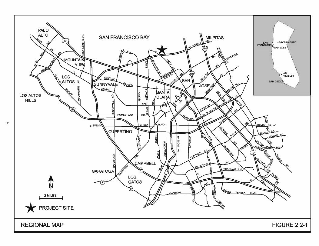
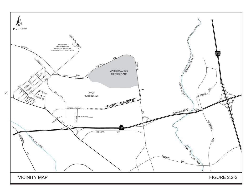
SECTION 2.0 PROJECT INFORMATION 2.1 PROJECT TITLE San Jose/Santa Clara Water Pollution Control Plant Nortech/Zanker Service Lateral Project 2.2 PROJECT LOCATION The project site is located north of State Route 237 and south of the San Jose/Santa Clara Water Pollution Control Plant (Plant) on Los Esteros Road. The new service lateral would connect to the existing potable service lateral on Nortech Parkway, traverse easterly approximately 4,295 linear feet across the Plant buffer land and redirect northerly for approximately 1,100 linear feet towards the South Bay Advanced Recycled Water Treatment Facility (ARWTF) (currently under construction) (refer to Figures 2.2-1, 2.2-2, and 2.2-3). 2.3 LEAD AGENCY CONTACT Janis Moore, Planner II Environmental Review Section City of San Jose Department of Planning, Building and Code Enforcement 200 E. Santa Clara Street, Tower, 3rd Floor San Jose, CA 95113 408-535-7815 2.4 PROJECT PROPONENT Darwin Lasat Water Resources Division San Jose Municipal Water System City of San Jose 3024 Tuers Road San Jose, CA 95121 408-363-4709 2.5 ASSESSOR’S PARCEL NUMBERS Portions of 015-030-061, 015-030-098, 015-31-028, 015-031-061, 015-031-063 2.6 ZONING DISTRICT AND GENERAL PLAN DESIGNATIONS General Plan Designation: Public/Quasi-Public Zoning District: West of Zanker Road: Single-Family Residential (R-1-8),
Multi-Family Residential (R-M), and Agricultural (A). East of Zanker Road: Light Industrial (LI)
Nortech/Zanker Service Lateral 3 Initial Study City of San José January 2012
Surrounding Zoning: North: Single-Family Residential (R-1-8), Multi-Family Residential (R-M), Agricultural (A), and Light Industrial (LI). South: Single-Family Residential (R-1-8), Multi-Family Residential (R-M), Agricultural (A), and Light Industrial (LI). East: Single-Family Residential (R-1-8), Multi-Family Residential (R-M), Agricultural (A), and Light Industrial (LI).
West: A(PD) (industrial park uses), Single-Family Residential (R-1-8), Multi-Family Residential (R-M), and Agricultural (A).
Surrounding General Plan: North: Public/Quasi-Public South: Public/Quasi-Public East: Public/Quasi-Public West: Public/Quasi-Public, Combined Industrial Commercial
Surrounding Land Uses: North: vacant WPCP buffer land South: vacant WPCP buffer land East: ARWTF (under construction) and vacant WPCP buffer land West: industrial park and water tank
WATER POLLUTION
CONTROL PLANT
GUADALUPE RIVER
COYO
TE CREEK
LAFAYETTE ST.
GRAND
BLVD.
MICHIG
AN
AV.
WABASH
ST.
S
TATE
ST.
SPRECKLES AV.
San Jose City Lim
it
ARCHER ST.
ESSEX ST.
PACIFIC ST.
DON EDWARDSSAN FRANCISCO BAY
NATIONAL WILDLIFE REFUGEENVIRONMENTAL EDUCATION CENTER
LOS
ESTEROS
RD.
ZA
NKER RD
. McCARTH
Y BLVD.
880
237
N. 1ST. ST.
HOLGER WY.
T
TASMAN DR.
ALVISO-MILPITAS RD.
RANCH
DR.
1" = ± 1825'
M
ilpita
s C
ity
Lim
it
DISK DRIVE
WILSON WAY
JACKSON WAY
TRINITY PARK DR.
NORTECH PARKWAY
CURSOR CT.
FORT
RA
N
CT.
BAYTECH DRIVE
ARTESIAN SLOUGH U.P.R.R. SPUR
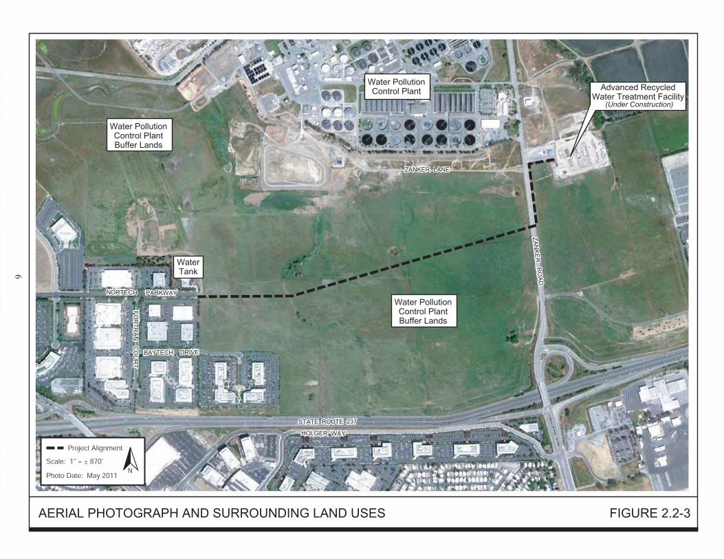
Nortech/Zanker Service Lateral 7 Initial Study City of San José January 2012
SECTION 3.0 PROJECT DESCRIPTION 3.1 BACKGROUND 3.1.1 San Jose Municipal Water System The San Jose Municipal Water System is owned and operated by the City of San Jose. In May 1961, the City of San Jose purchased the Evergreen Water Company and established the San Jose Municipal Water System (MWS). In 1966, the North San Jose and Alviso service areas were added to the MWS with the annexation of the City of Alviso. In 1983 and 1986, the Council established the Edenvale and Coyote service areas, respectively. Since inception, the MWS has grown from a relatively small water utility to the fourth largest water retailer in the County of Santa Clara, with almost 27,000 connections serving a growing population currently estimated at over 115,000. The San Jose Municipal Water System purchases a blend of Hetch Hetchy water and treated water from San Francisco Public Utilities Commission (SFPUC) and delivers it to customers in the Alviso and North San Jose areas.1
The proposed service lateral will be served by the San Jose Municipal Water System’s overall potable network. 3.1.2 South Bay Advanced Recycled Water Treatment Facility The South Bay Advanced Recycled Water Treatment Facility (ARWTF), currently under construction, has been designed to treat secondary effluent from the existing Plant with advanced tertiary treatment to produce high-purity effluent with low total dissolved solids (TDS) concentration. The high-purity effluent from the ARTWF will blend with tertiary effluent from the Plant and feed into the South Bay Water Recycling (SBWR) system. The blended water will enhance recycled water quality to expand its marketability and usage. The ARWTF site is adjacent to the existing Plant on the east side of Zanker Road north of State Route 237, at the south end of the San Francisco Bay.2
The ARWTF is a joint project between the Santa Clara Valley Water District and the City of San Jose.
In February 2010, the South Bay ARWTF Final Environmental Assessment/Initial Study was adopted by the Board of the Santa Clara Valley Water District and by the San Jose City Council in March 2010, and subsequently approved for development. At the time the ARWTF was undergoing the planning and design stage, providing a potable water backup supply was not part of the project. It was not until after the environmental review for the ARWTF project was completed that project proponents determined this feature would be needed to maintain service reliability and quality in the event of a power failure or maintenance at the ARWTF. As a result, a new potable service lateral has been planned to provide this backup potable water supply as discussed in detail in Section 3.2 Project Description below.
1 San José Municipal Water System. http://www.sjmuniwater.com/. Accessed June 21, 2011. 2 Santa Clara Valley Water District/U.S. Department of the Interior, Bureau of Reclamation. South Bay Advanced Recycled Water Treatment Facility, Final Environmental Assessment/Initial Study-Mitigated Negative Declaration. February 2010.
Nortech/Zanker Service Lateral 8 Initial Study City of San José January 2012
3.1.3 San Jose/Santa Clara Water Pollution Control Plant Built in 1956, the San Jose/Santa Clara Water Pollution Control Plant cleans an average of 110 million gallons of wastewater per day. The Plant serves eight cities with 1.4 million residents and more than 17,000 main sewer connections for businesses. To address long-range planning at the Plant, the Cities of San Jose and Santa Clara and several tributary agencies initiated a master planning process in 2009 to achieve various operational, economic, environmental, and social goals. A Notice of Preparation (NOP) of a Draft Environmental Impact Report for the San Jose/Santa Clara Water Pollution Control Plant Master Plan (Plant Master Plan) was issued on May 23, 2011.3
The Draft EIR is currently under preparation.
The proposed Plant Master Plan, if adopted and implemented, may involve future development of commercial, retail, and light industrial uses as well as open space and habitat restoration within the Plant buffer lands, where the proposed service lateral alignment is located. The Plant Master Plan is being evaluated in an EIR currently in preparation. Development of the buffer lands under the Plant Master Plan is contingent on a number of factors in addition to completion of the EIR and adoption of the Plant Master Plan. These factors include the phased conversion of biosolids handling at the Plant and submittal and evaluation of proposals from private developers. As such, the buffer lands are not expected to be developed for many years. The Plant Master Plan future development does not require or depend on completion of the proposed service lateral project in order for the Plant Master Plan to be approved and/or developed. In order to coordinate planning efforts with the proposed Plant Master Plan and to minimize impacts from project construction (assuming both projects are approved and implemented) as well as future service lateral repairs, the project proponents selected the service lateral alignment following a possible roadway identified in the recommended alternative of the Plant Master Plan. While the service lateral traverses the Plant buffer lands and is planned to share the alignment of a potential future roadway contemplated in the Plant Master Plan, the service lateral project evaluated in this Initial Study is not a related activity that facilitates or requires any possible development that would result from the Plant Master Plan; nor is it required to serve future Master Plan development. The service lateral has independent utility to provide a backup potable water supply to the ARWTF; it is not a contemplated future part of the Plant Master Plan. Further information about the Plant Master Plan development is not needed to make an informed decision whether or not to proceed with the service lateral project in that there is not a direct relationship between the two other than the service lateral is planned within the same potential future roadway alignment.
3 City of San José. Notice of Preparation of a Draft Environmental Impact Report for the San José/Santa Clara Water Pollution Control Plant Master Plan. May 23, 2011.
Nortech/Zanker Service Lateral 9 Initial Study City of San José January 2012
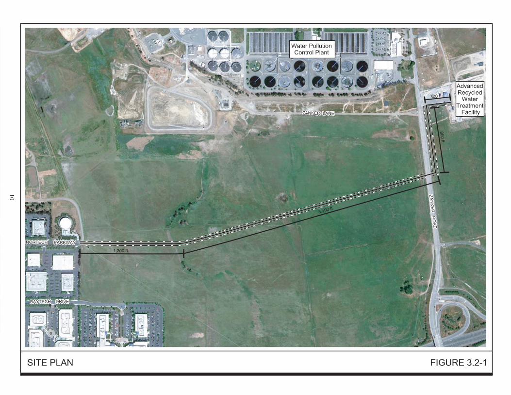
3.2 PROJECT DESCRIPTION The proposed project is the installation of a12-inch ductile iron pipe (DIP) potable water service lateral, approximately 5,400 linear feet in length, that will provide a source of water from an existing potable water system in Nortech Parkway to the ARWTF site currently under construction. 3.2.1 Project Purpose The purpose of the project is to provide a backup potable water supply to the ARWTF in the event of unanticipated system or operation disruptions related to loss of power supply or necessary maintenance. If the ARWTF recycled water pumps fail then the facility could switch the outflow to the proposed potable water supply in order to maintain water service reliability and water quality for the City’s recycled water customers. The potable water supply will remain unused until there is a need related to an interruption or maintenance. The service lateral will be connected to the San Jose Municipal Water System, which is the local water retailer. The new service lateral will be maintained and owned by the Plant. 3.2.2 Service Lateral Alignment The service lateral will be located within the public right-of-way or other public land. The service lateral will extend east from the terminus of Nortech Parkway approximately 1,200 linear feet across the undeveloped Plant buffer lands. The service lateral will then shift slightly north for approximately 3,100 linear feet toward Zanker Road. At Zanker Road, the service lateral alignment will cross under Zanker Road and turn north for 800 linear feet to the entrance driveway of the ARWTF and Zanker Road. At ARWTF driveway, the service lateral will extend east approximately 300 linear feet to a connection with the ARWTF (refer to Figure 3.2-1). Adjacent to Zanker Road, the service lateral will be located within the public right-of-way in such a way as to avoid existing underground utilities. The service lateral alignment will be designed to avoid existing utilities (e.g. recycled water line, overhead PG&E transmission lines, natural gas lines, and sanitary sewer main). The service lateral depth would be approximately six feet below ground surface over the length of the alignment. The depth of the service lateral would vary depending on the location of existing utilities, with vertical deflection as necessary to avoid these lines. The service lateral would be constructed of 12-inch diameter ductile iron pipe (DIP). The potable water supplied by the proposed service lateral to the ARWTF will be 2,000 gallon per minute. 3.2.3 Construction Methods, Access, and Staging The proposed potable water service lateral will be installed by the cut-and-cover method of trench excavation. Trench excavation will require the use of an excavator and dump truck, which will haul the excavated material to the staging areas for temporary storage. Excavated material will be recycled as backfill, where appropriate, and no off-hauling of material from the buffer lands will be required. At locations where the alignment crosses existing utilities, the material around the existing utilities will be excavated by hand. For safety, open trenches in or near the roadway will be covered with steel plates when construction activity is not taking place. The service lateral trench will be approximately four to five feet wide along the alignment. A 40-foot wide construction zone along the service lateral alignment will be utilized for vehicle access, equipment storage, and material staging (refer to Figure 3.2-1). The land and pavement disturbed
NORTECH PARKWAY
FO
RT
RA
N C
OU
RT
BAYTECH DRIVE
NORTECH PARKWAY
HOLGER WAY
BAYTECH DRIVE
STATE ROUTE 237
ZA
NK
ER
RO
AD
ZA
NK
ER
RO
AD
Water PollutionControl Plant
Advanced Recycled
Water Treatment
Facility
Nortech/Zanker Service Lateral 11 Initial Study City of San José January 2012
during the project will be restored to existing or better conditions through backfill and surface restoration. Construction staging, including lay down of materials (e.g., pipe lengths) and storage of excavated materials would take place along the 40-foot wide working area across the buffer land and on the shoulder along Zanker Road. Equipment and materials needed for construction will be transported to the construction site from the staging area on a daily, as-needed basis. If the project is approved, construction will take place over approximately three months. Heavy vehicle traffic will include approximately one dump truck twice per day to deliver bedding material, and one flat-bed truck per day to deliver pipe. Other equipment required to complete the project will include a backhoe, excavator, and utility truck. Since entire Plant and buffer land is surrounded by fencing, the project site will be accessed through a chain-link fence gate at the terminus of Nortech Parkway (at the west end of service lateral) and from Zanker Road across from Thomas Foon Chew Way, depending on the location of construction activities.
Nortech/Zanker Service Lateral 12 Initial Study City of San José January 2012
SECTION 4.0 ENVIRONMENTAL CHECKLIST AND DISCUSSION OF IMPACTS
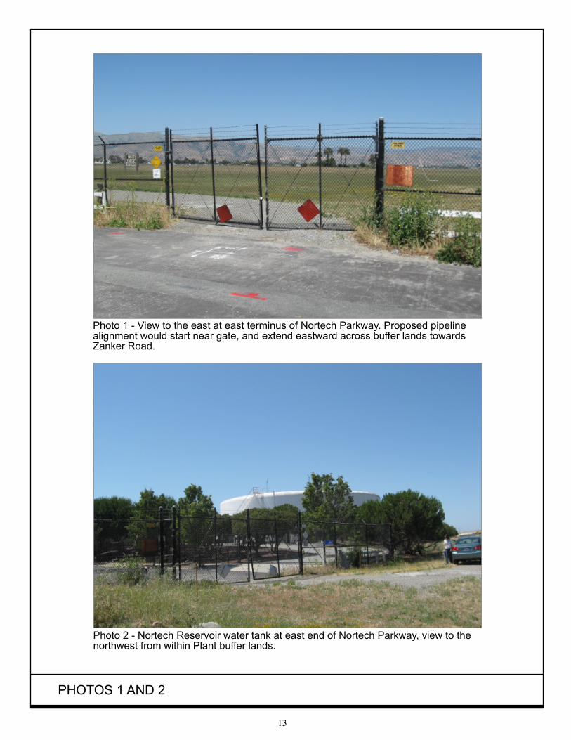
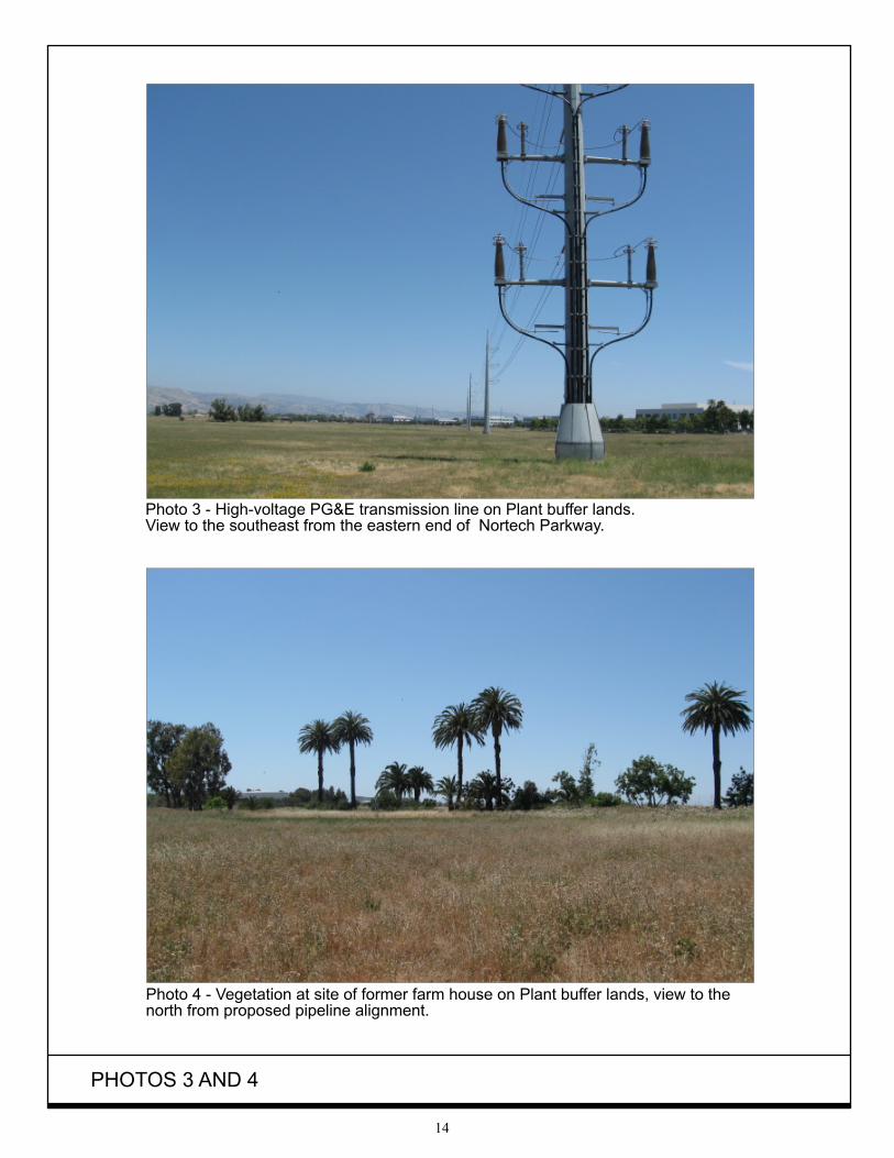
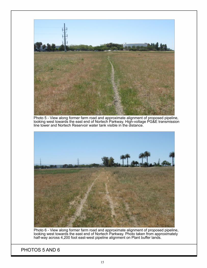
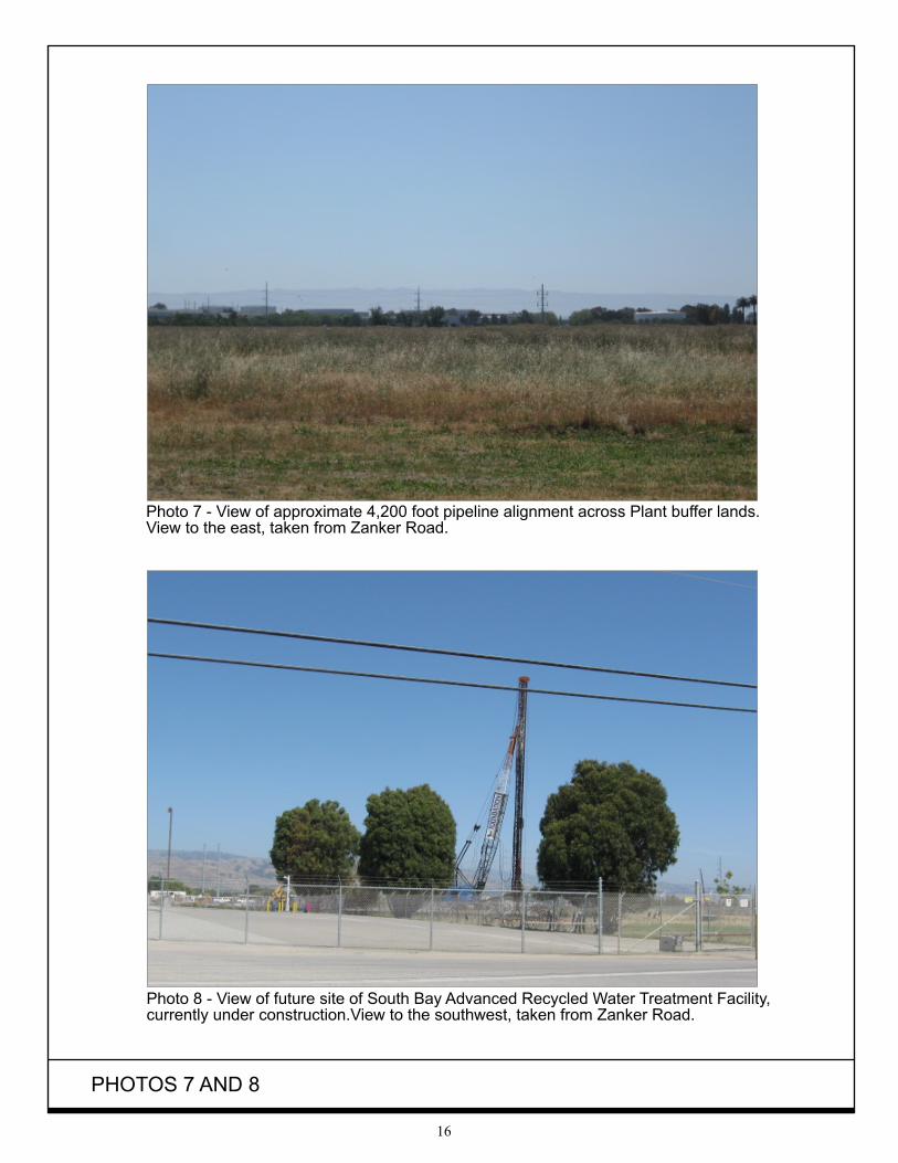
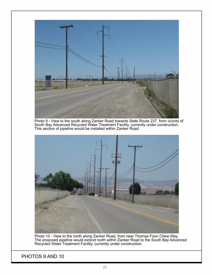
This section describes the existing environmental conditions on and near the project area, as well as environmental impacts associated with the proposed project. The environmental checklist, as recommended in the California Environmental Quality Act (CEQA) Guidelines, identifies environmental impacts that could occur if the proposed project is implemented. The right-hand column in the checklist lists the source(s) for the answer to each question. The sources cited are identified at the end of this section. Mitigation measures are identified for all significant project impacts. Measures that are standard and required by the City or law are categorized as “Standard Measures.” Measures that are proposed by the applicant that will further reduce already less than significant impacts are categorized as “Avoidance Measures.” Measures that are required to reduce significant impacts to a less than significant level are categorized as “Mitigation Measures.” All measures shall be printed on all construction documents, contracts, and project plans. 4.1 AESTHETICS 4.1.1 Existing Setting The project site is located north of State Route (SR) 237 on undeveloped San Jose/Santa Clara Water Pollution Control Plant (“Plant”) buffer lands. The project site vegetation consists of low-lying grasses as shown in Photos 1-7. A gravel and paved segment of the project site is located adjacent to Zanker Road as shown in Photos 8-10. A light industrial/office park development is located adjacent to the west end of the proposed service lateral. The office park includes paved surface parking lots, one and two-story buildings, and landscaping. Industrial uses, including the Plant, are located north of the service lateral alignment. The Plant includes seven multiple-level industrial buildings, a series of tanks, surface parking lots, and other outdoor processing equipment, as well as a complex of sludge ponds and mature trees. Further north of the project area are two landfill and resource recovery facilities: the Zanker Material Processing Facility (ZMPF) and the Zanker Road Resource Recovery Operation and Landfill (ZRRROL). Both of these facilities are elevated above the natural landscape and surrounded by mature trees. These facilities include one-story buildings, recycle sorting machinery, material piles, and haul trucks. Other industrial uses are located east of the project site, including South Bay Advanced Recycled Water Treatment Facility (under construction) and the Calpine Los Esteros Critical Energy Facility. State Route 237 is located south of the service lateral alignment and additional office and light industrial uses are further south. The residential area of Alviso, referred to in the Alviso Master Plan as the Alviso Village, is located approximately 0.75 miles northwest of the closest part of the service lateral alignment. The Alviso Village is a mixed of older single-family detached houses and newer attached residential houses. Open space comprised of grasslands, waterways, and marshes are found farther north of the project area beyond the Plant and landfill and resource recovery facilities, including the Don Edwards San Francisco Bay National Wildlife Refuge (NWR).
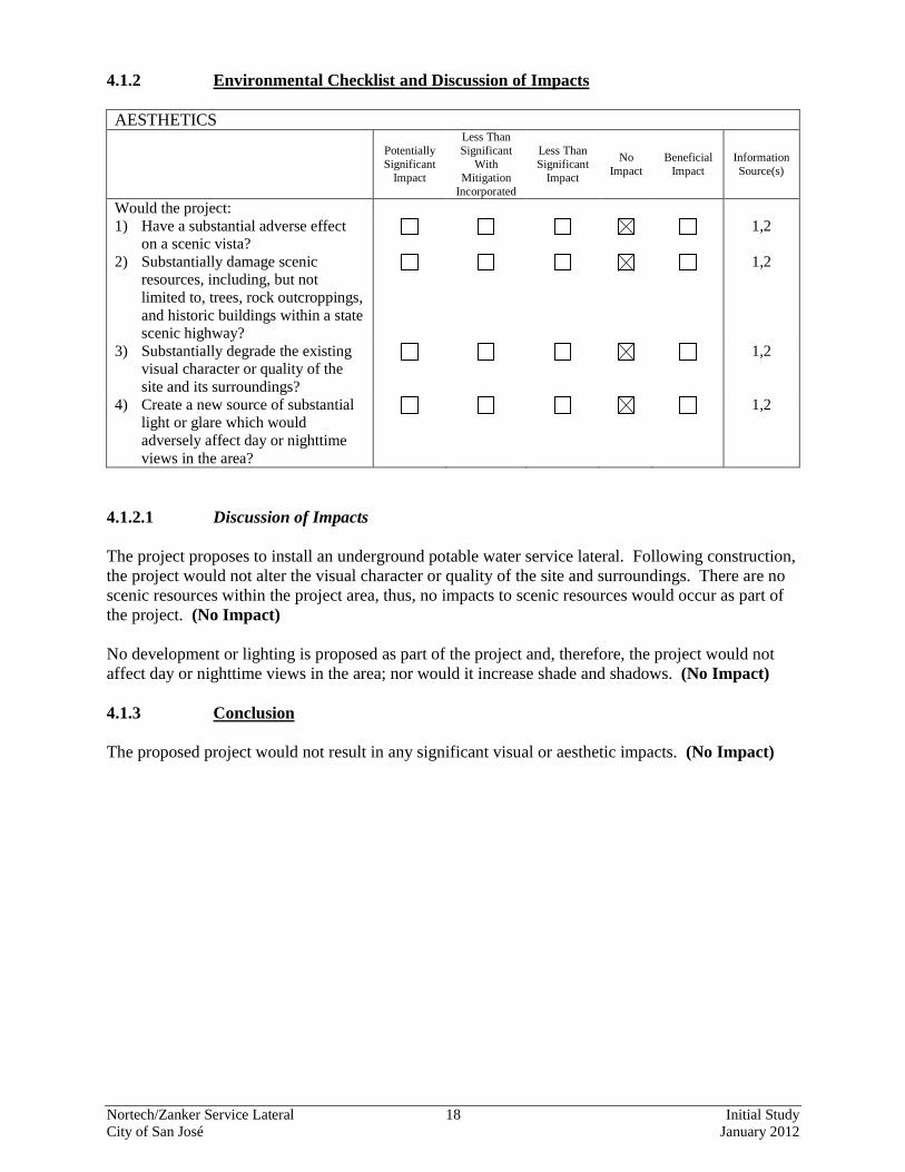
Nortech/Zanker Service Lateral 18 Initial Study City of San José January 2012
4.1.2 Environmental Checklist and Discussion of Impacts AESTHETICS
Potentially Significant
Impact
Less Than Significant
With Mitigation
Incorporated
Less Than Significant
Impact
No Impact
Beneficial Impact
Information Source(s)
Would the project: 1) Have a substantial adverse effect
on a scenic vista? 1,2
2) Substantially damage scenic resources, including, but not limited to, trees, rock outcroppings, and historic buildings within a state scenic highway?
1,2
3) Substantially degrade the existing visual character or quality of the site and its surroundings?
1,2
4) Create a new source of substantial light or glare which would adversely affect day or nighttime views in the area?
1,2
4.1.2.1 Discussion of Impacts The project proposes to install an underground potable water service lateral. Following construction, the project would not alter the visual character or quality of the site and surroundings. There are no scenic resources within the project area, thus, no impacts to scenic resources would occur as part of the project. (No Impact) No development or lighting is proposed as part of the project and, therefore, the project would not affect day or nighttime views in the area; nor would it increase shade and shadows. (No Impact) 4.1.3 Conclusion The proposed project would not result in any significant visual or aesthetic impacts. (No Impact)
Nortech/Zanker Service Lateral 19 Initial Study City of San José January 2012
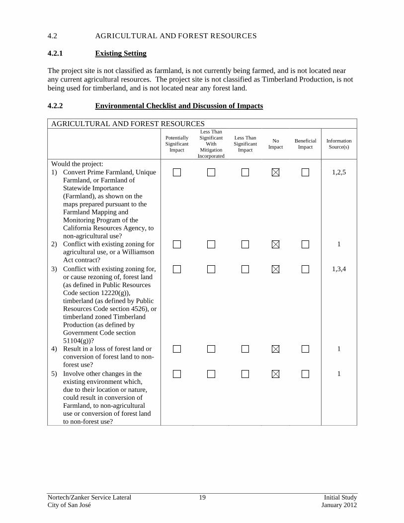
4.2 AGRICULTURAL AND FOREST RESOURCES 4.2.1 Existing Setting The project site is not classified as farmland, is not currently being farmed, and is not located near any current agricultural resources. The project site is not classified as Timberland Production, is not being used for timberland, and is not located near any forest land. 4.2.2 Environmental Checklist and Discussion of Impacts AGRICULTURAL AND FOREST RESOURCES
Potentially Significant
Impact
Less Than Significant
With Mitigation
Incorporated
Less Than Significant
Impact
No Impact
Beneficial Impact
Information Source(s)
Would the project: 1) Convert Prime Farmland, Unique
Farmland, or Farmland of Statewide Importance (Farmland), as shown on the maps prepared pursuant to the Farmland Mapping and Monitoring Program of the California Resources Agency, to non-agricultural use?
1,2,5
2) Conflict with existing zoning for agricultural use, or a Williamson Act contract?
1
3) Conflict with existing zoning for, or cause rezoning of, forest land (as defined in Public Resources Code section 12220(g)), timberland (as defined by Public Resources Code section 4526), or timberland zoned Timberland Production (as defined by Government Code section 51104(g))?
1,3,4
4) Result in a loss of forest land or conversion of forest land to non-forest use?
1
5) Involve other changes in the existing environment which, due to their location or nature, could result in conversion of Farmland, to non-agricultural use or conversion of forest land to non-forest use?
1
Nortech/Zanker Service Lateral 20 Initial Study City of San José January 2012
4.1.2.1 Discussion of Impacts Agricultural uses have not occurred on the project site or adjacent to the project site for several decades. There is no Williamson Act contract on the property. The proposed project would not affect farmland or agricultural uses in any way. The project would, therefore, have no impact on farmland or agricultural activities of any kind. (No Impact) The project site does not include forest land, nor has any timberland production taken place on the project site. The proposed project would not affect forest land or timberland uses in any way. The project would, therefore, have no impact on forest land or timberland activities of any kind. (No Impact) 4.2.3 Conclusion The proposed project would not impact farmlands or agricultural activities. (No Impact)
Nortech/Zanker Service Lateral 21 Initial Study City of San José January 2012
4.3 AIR QUALITY 4.3.1 Existing Setting Air quality and the amount of a given pollutant in the atmosphere are determined by the amount of pollutant released and the atmosphere’s ability to transport and dilute the pollutant. The major determinants of transport and dilution are wind, atmospheric stability, terrain and, for photochemical pollutants, sunlight. Of the three pollutants known to at times exceed the state and federal standards in the project area, two are regional pollutants. Both ozone and particulate matter (PM10) are considered regional pollutants in that concentrations are not determined by proximity to individual sources, but show a relative uniformity over a region. The third pollutant, carbon monoxide, is considered a local pollutant because elevated concentrations are usually only found near the source. Under amendments to the federal Clean Air Act, the Environmental Protection Agency (EPA) has classified air basins, or portions thereof, as either “attainment” or “nonattainment” for each criteria air pollutant, based on whether or not the national standards have been achieved. Under the California Clean Air Act, Santa Clara County is classified as a non-attainment area for ozone and PM10. The EPA has designated the Bay Area as a federal non-attainment area for ozone. The County is either in attainment or unclassified for other pollutants. 4.3.2 Environmental Checklist and Discussion of Impacts AIR QUALITY
Potentially Significant
Impact
Less Than Significant
With Mitigation
Incorporated
Less Than Significant
Impact
No Impact
Beneficial Impact
Information Source(s)
Would the project: 1) Conflict with or obstruct
implementation of the applicable air quality plan?
1,6
2) Violate any air quality standard or contribute substantially to an existing or projected air quality violation?
1,6
3) Result in a cumulatively considerable net increase of any criteria pollutant for which the project region is classified as non-attainment under an applicable federal or state ambient air quality standard including releasing emissions which exceed quantitative thresholds for ozone precursors?
1,6
4) Expose sensitive receptors to substantial pollutant concentrations?
1,6
Nortech/Zanker Service Lateral 22 Initial Study City of San José January 2012
AIR QUALITY
Potentially Significant
Impact
Less Than Significant
With Mitigation
Incorporated
Less Than Significant
Impact
No Impact
Beneficial Impact
Information Source(s)
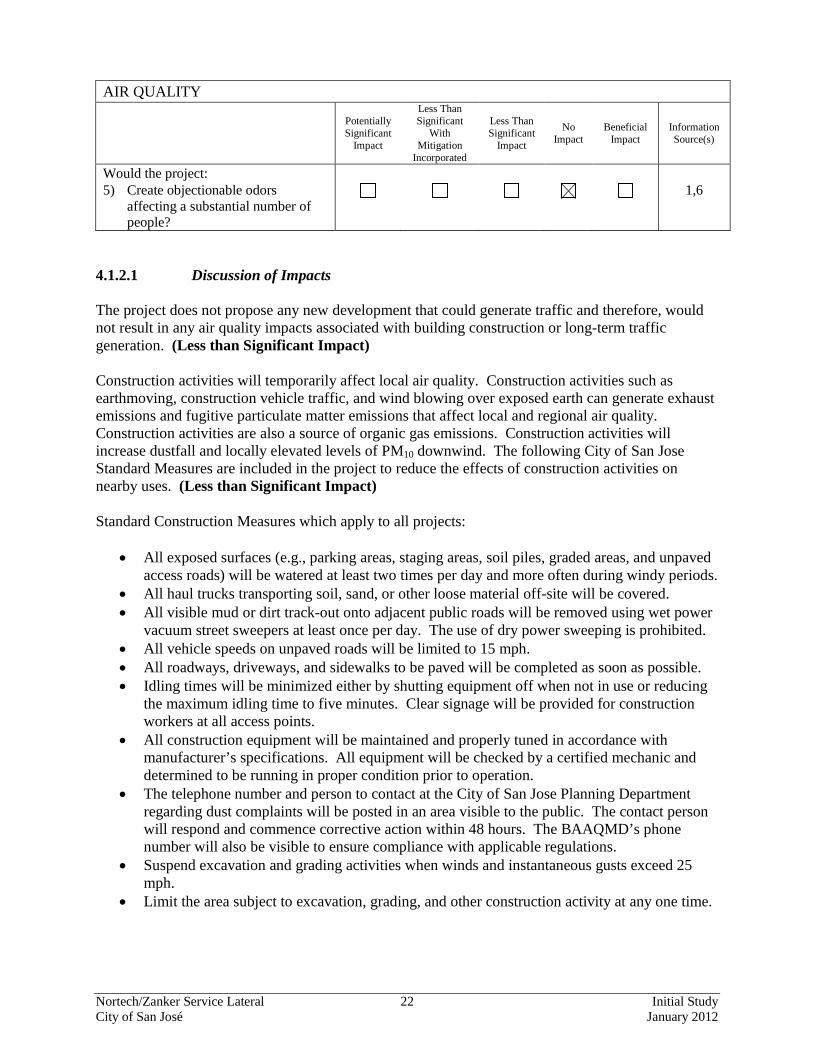
Would the project: 5) Create objectionable odors
affecting a substantial number of people?
1,6
4.1.2.1 Discussion of Impacts The project does not propose any new development that could generate traffic and therefore, would not result in any air quality impacts associated with building construction or long-term traffic generation. (Less than Significant Impact) Construction activities will temporarily affect local air quality. Construction activities such as earthmoving, construction vehicle traffic, and wind blowing over exposed earth can generate exhaust emissions and fugitive particulate matter emissions that affect local and regional air quality. Construction activities are also a source of organic gas emissions. Construction activities will increase dustfall and locally elevated levels of PM10 downwind. The following City of San Jose Standard Measures are included in the project to reduce the effects of construction activities on nearby uses. (Less than Significant Impact) Standard Construction Measures which apply to all projects:
• All exposed surfaces (e.g., parking areas, staging areas, soil piles, graded areas, and unpaved access roads) will be watered at least two times per day and more often during windy periods.
• All haul trucks transporting soil, sand, or other loose material off-site will be covered. • All visible mud or dirt track-out onto adjacent public roads will be removed using wet power
vacuum street sweepers at least once per day. The use of dry power sweeping is prohibited. • All vehicle speeds on unpaved roads will be limited to 15 mph. • All roadways, driveways, and sidewalks to be paved will be completed as soon as possible. • Idling times will be minimized either by shutting equipment off when not in use or reducing
the maximum idling time to five minutes. Clear signage will be provided for construction workers at all access points.
• All construction equipment will be maintained and properly tuned in accordance with manufacturer’s specifications. All equipment will be checked by a certified mechanic and determined to be running in proper condition prior to operation.
• The telephone number and person to contact at the City of San Jose Planning Department regarding dust complaints will be posted in an area visible to the public. The contact person will respond and commence corrective action within 48 hours. The BAAQMD’s phone number will also be visible to ensure compliance with applicable regulations.
• Suspend excavation and grading activities when winds and instantaneous gusts exceed 25 mph.
• Limit the area subject to excavation, grading, and other construction activity at any one time.
Nortech/Zanker Service Lateral 23 Initial Study City of San José January 2012
4.3.3 Conclusion Short-term air quality impacts associated with service lateral installation activities would be considered less than significant. The project would not result in significant air quality impacts. (Less Than Significant Impact)
Nortech/Zanker Service Lateral 24 Initial Study City of San José January 2012
4.4 BIOLOGICAL RESOURCES The following discussion is based on a biological resources report prepared by HT Harvey & Associates in September 2011. The report is located in Appendix A. 4.4.1 Existing Setting Three biotic habitats/land use types were found within the project area: ruderal/non-native grassland, seasonal wetlands, and developed. These habitats are described below. 4.4.1.1 Biological Habitats
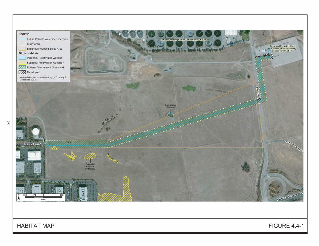
Ruderal/Non-Native Grassland The project area includes ruderal/non-native grassland habitat that has been intensively disturbed as a result of many years of land use practices including regular disking or mowing and are currently grazed or mown at least once each year as a fire suppression tactic. At the time of the 2011 site visits, much of the ruderal vegetation within and around the proposed service lateral alignment had been recently grazed by sheep and goats, leaving patches of bare ground and plants with short, stunted growth. The heavy clay soils on the west side of the project area support a variety of common, non-native herbaceous species such as Italian ryegrass, Mediterranean barley, alkali mallow, and bristly ox-tongue, that are known to occur on both dry and moderately moist soils. As the soils become well-drained toward the eastern end of the project area, the dominant non-native grassland species change toward more drought tolerant species that typically inhabit uplands. Due to heavy grazing, the vegetation on the east side of Zanker Road within the proposed service lateral alignment is very sparse, being composed of short (2-3 inch) Mediterranean barley, and grazed Italian thistle. Bird species observed using the grasslands in the project area during the reconnaissance survey include American kestrels, black phoebes, house finches, red-winged blackbirds, and lesser goldfinches. Other grassland-associated bird species known to occur in the area, based on previous wildlife surveys, include white-tailed kites, red-tailed hawks, mourning doves, barn swallows, tree swallows, northern mockingbirds, loggerhead shrikes, white-crowned sparrows, western meadowlarks, and Brewer’s blackbirds. No burrowing owls were seen during the reconnaissance survey, and a thorough survey revealed no burrows of California ground squirrels within the project area and a surrounding 250-foot buffer. No nesting or roosting burrowing owls are currently present within the project area, however, burrowing owls have been observed in close proximity to the project area in the recent past (2008), and suitable foraging habitat is present throughout the grasslands in the project area. As a result, burrowing owls are expected to forage in the project area.
Seasonal Wetlands One relatively small patch of seasonal wetlands was identified within the 40-foot construction zone of the project area but outside the service lateral alignment (Figure 4.4-1). Additionally, although outside of the current project area boundaries, three seasonal wetlands were observed within approximately 50 to 100 feet south of the proposed alignment (see Figure 4.4-1). These wetlands were identified during 2006/2007 surveys and all of them occur within approximately 1,500 feet of the terminus of Nortech Parkway. These wetlands appear to pond water within shallow topographic depressions that
Nortech/Zanker Service Lateral 26 Initial Study City of San José January 2012
are saturated at a frequency and duration sufficient to support wetland vegetation. The seasonal wetlands support many of the same species that were identified in the moderately moist habitat areas of the ruderal annual grassland habitat such as bristly ox-tongue, Italian ryegrass, and alkali mallow. These wetlands also support more aquatic species such as annual beard grass, common spikerush, and curly dock. Wetland habitats often serve as important foraging and breeding habitat for a wide variety of wildlife species, however, the wetland within the project area, and those nearby, are of marginal value to wildlife due to their small size, limited hydraulic saturation period, and isolation from more extensive wetlands. No wetland-associated wildlife species were observed during the reconnaissance survey. Common species that might occur in these wetlands include the Pacific chorus frog and western toad, as well as the common bird and mammal species associated with the adjacent ruderal/non-native grassland habitat. Grassland-associated bird species likely forage in and over these wetlands and obtain drinking water when pools are formed. Bats and other small mammals foraging in the project area will also use these wetlands for foraging and drinking opportunities.
Developed A segment of the project site crosses through developed habitat (e.g., Zanker Road) and areas that are currently being developed (e.g., the ARWTF site) on the east end of the project area. At the time of the 2011 reconnaissance survey, the ARWTF was actively being constructed in the northernmost portion of the project area. Most of this construction area was bare, graded soils with heavy construction equipment operating throughout the area. The only vegetation present in this habitat was small patches of ruderal weeds along fence lines that had not been graded. Because the developed habitats within the project area consist of an active construction site and a heavily traveled roadway, no wildlife species are expected to make substantial use of these habitats. Species that occur in nearby grassland, wetland, and developed habitats (described above) may make occasional use of these areas during transit or foraging during periods of light traffic and when construction is inactive. 4.4.1.2 Special-Status Plants and Animals Federal and state endangered species legislation gives special-status to several plant and animal species known to occur in the vicinity of the project area. Such species are referred to collectively as “species of special status” and include plants and animals listed, proposed for listing, or candidates for listing as threatened or endangered under the Federal Endangered Species Act (FESA) or the California Endangered Species Act (CESA); animals listed as “fully protected” under the California Fish and Game (CDFG) Code; animals designated as “species of special concern” by the CDFG; and plants listed as rare or endangered by California Native Plant Society (CNPS). Prior to the field survey, a search of special-status plants and animals in the California Natural Diversity Database (CNDDB) was completed for the U.S. Geological Survey Milpitas topographical quadrangle, in which the project area occurs, and the surrounding eight quadrangles. The CNPS Inventory was then queried to produce a similar plant list for Santa Clara County. Reconnaissance-level botanical and wildlife surveys were completed on June 6, 2011 and August 29, 2011 for the project site by a plant ecologist and wildlife ecologist for habitats capable of supporting special-status plant and animal species. The entire project area, plus areas within 250 feet of the
Nortech/Zanker Service Lateral 27 Initial Study City of San José January 2012
project area (for purposes of reconnaissance level burrowing owl surveys), were walked while the ecologist searched for evidence of special-status species and suitable habitat for such species. The special-status plant and animal species that occur in the vicinity in habitats similar to those found in the project area are described below.
Special-status Plant Species Most of the special-status plant species were rejected from consideration for occurrence due to the degraded nature of habitat in the project area, the lack of associated native species, and/or the absence of specific microhabitat variables such as soil type or hydrology. It was determined that only one species, Congdon’s tarplant, could potentially occur in the project area in its present condition. There are two CNDDB occurrences of Condon’s tarplant within two miles of the project area. One of these occurrences is less than 1/2 mile northwest of the project area in a field bounded by Grand Avenue, Wilson Way, Nortech Parkway, and Disk Drive. Marginally suitable habitat for Congdon’s tarplant is present in the disturbed non-native grassland habitat in the project area. The plant ecologist specifically searched for Congdon’s tarplant during the June and August surveys, a time of year appropriate for detecting the species if it was present, and Congdon’s tarplant was not detected in the project area during either survey. Thus, Congdon’s tarplant was determined to be absent from the project area.
Special-status Animal Species
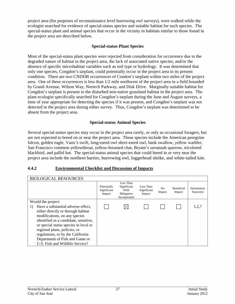
Several special-status species may occur in the project area rarely, or only as occasional foragers, but are not expected to breed on or near the project area. These species include the American peregrine falcon, golden eagle, Vaux’s swift, long-eared owl short-eared owl, bank swallow, yellow warbler, San Francisco common yellowthroat, yellow-breasted chat, Bryant’s savannah sparrow, tricolored blackbird, and pallid bat. The special-status animal species that could breed in or very near the project area include the northern harrier, burrowing owl, loggerhead shrike, and white-tailed kite. 4.4.2 Environmental Checklist and Discussion of Impacts BIOLOGICAL RESOURCES
Potentially Significant
Impact
Less Than Significant
With Mitigation
Incorporated
Less Than Significant
Impact
No Impact
Beneficial Impact
Information Source(s)
Would the project: 1) Have a substantial adverse effect,
either directly or through habitat modifications, on any species identified as a candidate, sensitive, or special status species in local or regional plans, policies, or regulations, or by the California Department of Fish and Game or U.S. Fish and Wildlife Service?
1,2,7
Nortech/Zanker Service Lateral 28 Initial Study City of San José January 2012
BIOLOGICAL RESOURCES
Potentially Significant
Impact
Less Than Significant
With Mitigation
Incorporated
Less Than Significant
Impact
No Impact
Beneficial Impact
Information Source(s)
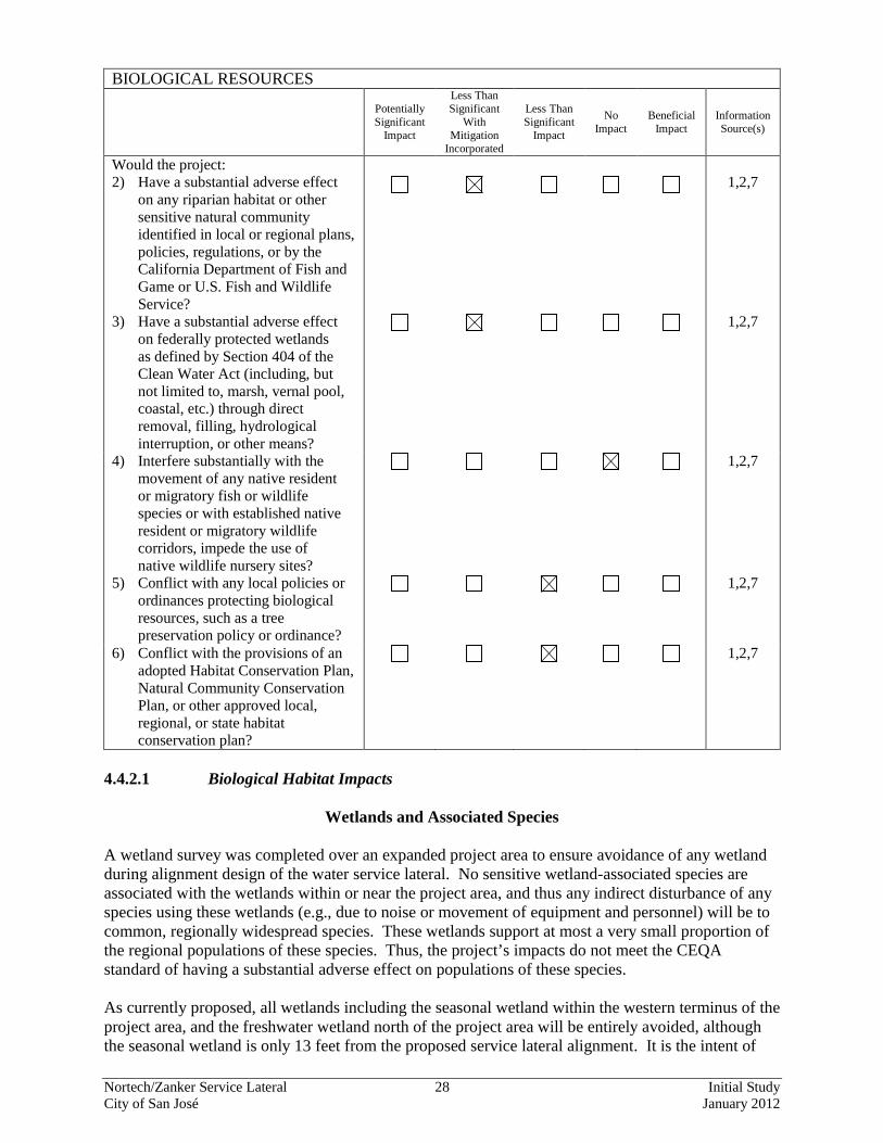
Would the project: 2) Have a substantial adverse effect
on any riparian habitat or other sensitive natural community identified in local or regional plans, policies, regulations, or by the California Department of Fish and Game or U.S. Fish and Wildlife Service?
1,2,7
3) Have a substantial adverse effect on federally protected wetlands as defined by Section 404 of the Clean Water Act (including, but not limited to, marsh, vernal pool, coastal, etc.) through direct removal, filling, hydrological interruption, or other means?
1,2,7
4) Interfere substantially with the movement of any native resident or migratory fish or wildlife species or with established native resident or migratory wildlife corridors, impede the use of native wildlife nursery sites?
1,2,7
5) Conflict with any local policies or ordinances protecting biological resources, such as a tree preservation policy or ordinance?
1,2,7
6) Conflict with the provisions of an adopted Habitat Conservation Plan, Natural Community Conservation Plan, or other approved local, regional, or state habitat conservation plan?
1,2,7
4.4.2.1 Biological Habitat Impacts
Wetlands and Associated Species A wetland survey was completed over an expanded project area to ensure avoidance of any wetland during alignment design of the water service lateral. No sensitive wetland-associated species are associated with the wetlands within or near the project area, and thus any indirect disturbance of any species using these wetlands (e.g., due to noise or movement of equipment and personnel) will be to common, regionally widespread species. These wetlands support at most a very small proportion of the regional populations of these species. Thus, the project’s impacts do not meet the CEQA standard of having a substantial adverse effect on populations of these species. As currently proposed, all wetlands including the seasonal wetland within the western terminus of the project area, and the freshwater wetland north of the project area will be entirely avoided, although the seasonal wetland is only 13 feet from the proposed service lateral alignment. It is the intent of
Nortech/Zanker Service Lateral 29 Initial Study City of San José January 2012
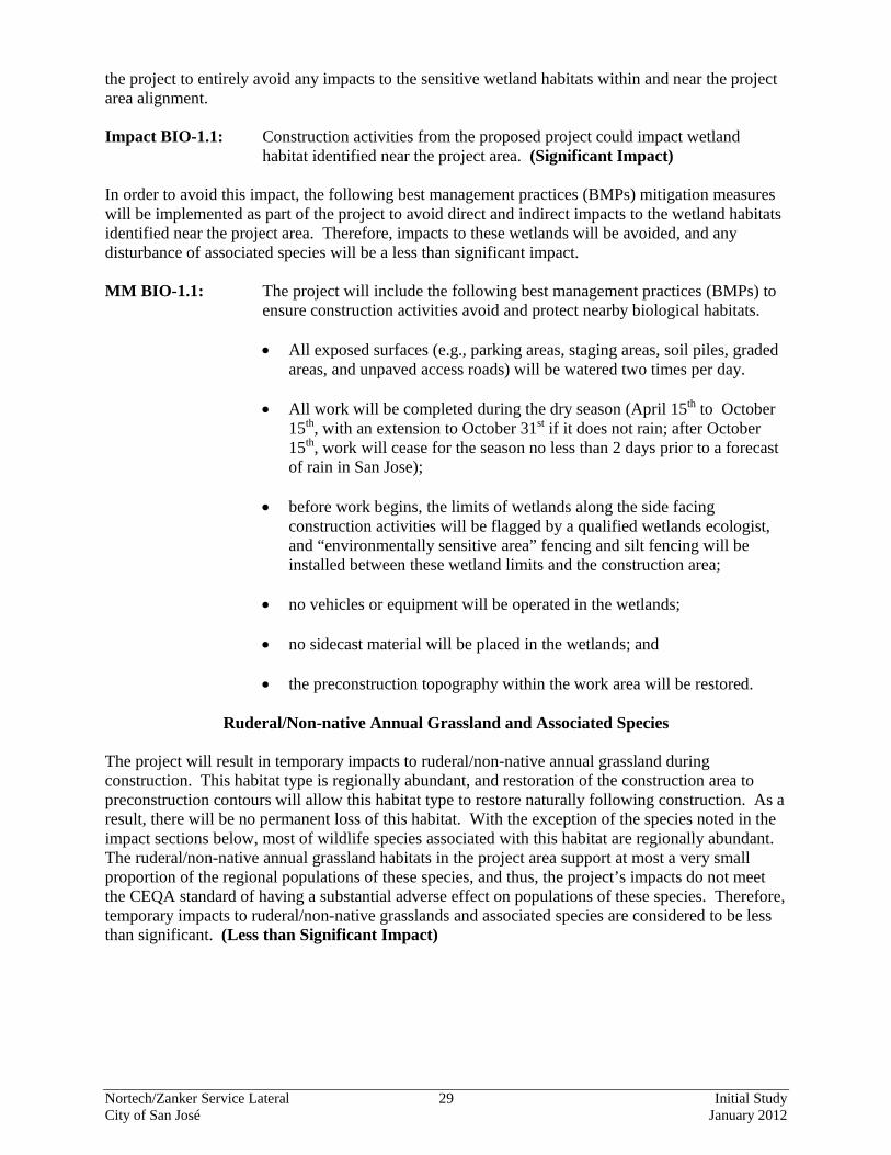
the project to entirely avoid any impacts to the sensitive wetland habitats within and near the project area alignment. Impact BIO-1.1: Construction activities from the proposed project could impact wetland
habitat identified near the project area. (Significant Impact) In order to avoid this impact, the following best management practices (BMPs) mitigation measures will be implemented as part of the project to avoid direct and indirect impacts to the wetland habitats identified near the project area. Therefore, impacts to these wetlands will be avoided, and any disturbance of associated species will be a less than significant impact. MM BIO-1.1: The project will include the following best management practices (BMPs) to
ensure construction activities avoid and protect nearby biological habitats.
• All exposed surfaces (e.g., parking areas, staging areas, soil piles, graded areas, and unpaved access roads) will be watered two times per day.
• All work will be completed during the dry season (April 15th to October 15th, with an extension to October 31st if it does not rain; after October 15th, work will cease for the season no less than 2 days prior to a forecast of rain in San Jose);
• before work begins, the limits of wetlands along the side facing construction activities will be flagged by a qualified wetlands ecologist, and “environmentally sensitive area” fencing and silt fencing will be installed between these wetland limits and the construction area;
• no vehicles or equipment will be operated in the wetlands;
• no sidecast material will be placed in the wetlands; and
• the preconstruction topography within the work area will be restored.
Ruderal/Non-native Annual Grassland and Associated Species The project will result in temporary impacts to ruderal/non-native annual grassland during construction. This habitat type is regionally abundant, and restoration of the construction area to preconstruction contours will allow this habitat type to restore naturally following construction. As a result, there will be no permanent loss of this habitat. With the exception of the species noted in the impact sections below, most of wildlife species associated with this habitat are regionally abundant. The ruderal/non-native annual grassland habitats in the project area support at most a very small proportion of the regional populations of these species, and thus, the project’s impacts do not meet the CEQA standard of having a substantial adverse effect on populations of these species. Therefore, temporary impacts to ruderal/non-native grasslands and associated species are considered to be less than significant. (Less than Significant Impact)
Nortech/Zanker Service Lateral 30 Initial Study City of San José January 2012
4.4.2.2 Special-Status Plants and Animals
Burrowing Owls
The reconnaissance-level surveys did not detect any evidence of burrowing owls in the project area or within 250 feet of the project area. No ground squirrel burrows are currently present in the project area and surrounding 250-ft buffer to support nesting or roosting burrowing owls. Burrowing owls are known to occur in the vicinity however, and the project area currently provides suitable foraging habitat for owls roosting or nesting in nearby areas. In addition, burrows of California ground squirrels have been observed in the project area in previous years, and ground squirrels may excavate burrows there again in the future. As a result, burrowing owls can currently use the project area for foraging, and could potentially use the project area for roosting or nesting if burrows occur there when construction of the service lateral occurs. A small amount of suitable foraging habitat for this species will be temporarily impacted by the project. Because the area to be impacted is so limited in extent compared to habitat available elsewhere in the vicinity (e.g., on other Plant lands), and because the ruderal/non-native annual grassland habitat will restore naturally following construction, such temporary habitat disturbance will not substantially affect this species. If ground squirrels excavate burrows in the project area in the future and owls are present within the project area during construction, excavation or side-casting of soil and movement of heavy equipment could potentially trap owls inside their burrows or crush owls in burrows, resulting in injury or mortality of individuals. Construction activity could also cause owls to abandon burrows that are adjacent to (i.e., within 250 feet of) the project area; abandonment of active nests during the breeding season (February 1st to August 31st) could result in the loss of eggs or young. Because burrowing owl populations are declining throughout much of their range in the United States, and particularly within the South Bay region, any impacts from the project that result in the injury or mortality of individual owls or active nests, such as excavation or grading, or project-related disturbance that results in the abandonment of eggs or nestlings, would be considered significant. Impact BIO-2.1: Construction activities from the proposed project could result in significant
impacts to burrowing owls. (Significant Impact) Implementation of the following mitigation measures will reduce burrowing owl impacts to a less than significant level. MM BIO-2.1: Pre-construction Surveys. Surveys for burrowing owls shall be completed by
a qualified ornithologist in potential habitat in conformance with the CDFG protocol prior to the start of any ground-disturbing construction activity. These surveys shall be initiated no more than 30 days prior to the start of construction, and the final site visit shall take place no more than 2 days prior to the start of construction. If no burrowing owls are located during these surveys, MM BIO-2.2 and 2.3 would not be required. If these surveys detect burrowing owls on or within 250 feet of the project area, then the following mitigation measures (MM BIO-2.2 and 2.3) shall be implemented. The project applicant shall submit a report indicating the results of the survey to the satisfaction of the City’s Director of Planning, Building and Code Enforcement prior to the start of ground disturbing activities.
MM BIO-2.2: Buffer Zones. If burrowing owls are present during the breeding season
(generally February 1 to August 31), a 250-foot buffer, within which no project-related activity will be permissible, shall be maintained between construction activities and occupied burrows. Owls present at burrows in the
Nortech/Zanker Service Lateral 31 Initial Study City of San José January 2012
project area after February 1st will be assumed to be nesting on or adjacent to the project area unless evidence indicates otherwise. This protected area shall remain in effect until August 31st or, based upon monitoring evidence, until the young owls are foraging independently. If burrowing owls are present adjacent to, but not within, the project’s disturbance footprint during the nonbreeding season, a buffer of 150 feet will be provided. A smaller buffer during the nonbreeding season (September 1st to January 31st) may be permitted as long as it deemed acceptable by a qualified ornithologist and the owl’s burrow is located far enough from the construction area that the burrow occupied by the owl is not in danger of being destroyed or caved-in. The project applicant shall submit a report indicating the results of the survey and any designated buffer zones to the satisfaction of the City’s Director of Planning, Building and Code Enforcement prior to the start of ground disturbing activities.
MM BIO-2.3: Relocation. If ground-disturbing activities will occur close enough to an
active burrow that the burrow is at risk of being destroyed, any owl(s) occupying the burrow shall be relocated during the non-breeding season, in consultation with the CDFG and the U.S. Wildlife Service, to avoid impacts to the bird(s). No burrowing owls shall be evicted from burrows during the nesting season (February 1st through August 31st) unless evidence indicates that nesting is not actively occurring (e.g., because the owls have not yet begun nesting early in the season, or because young have already fledged late in the season). As noted in MM BIO-1.2 above, owls will not be relocated during the nonbreeding season unless the occupied burrow is at imminent risk of being destroyed. The project applicant shall submit a report summarizing the consultation process with CDFG to the satisfaction of the City’s Director of Planning, Building and Code Enforcement prior to the start of ground disturbing activities.
Special-status Birds
While no birds were observed, up to one pair of white-tailed kites and two pairs of loggerhead shrikes could nest in trees within or near the project area. In addition, it is possible that the wetlands in the vicinity of the project area could support one pair of nesting northern harriers. Project construction will result in the temporary disturbance of potential nesting habitat for loggerhead shrikes, white-tailed kites, and possibly northern harriers and of potential foraging habitat for all three species. No nesting trees are proposed for removal however, and given the ample nesting and foraging habitat available elsewhere in the vicinity (e.g., on other Plant lands) and the expectation that the seasonal wetlands and ruderal/nonnative annual grassland habitat will restore naturally following construction, such temporary habitat disturbance will not substantially affect these species. Project activities could potentially cause abandonment of active nests of these species if noise, ground vibrations, and the movement of people and equipment in close proximity to nests (i.e., within 250 feet of a nest) occurs during the breeding season (roughly, February 1st through August 31st). Regional breeding populations of these species are relatively small; however, the proposed project is not expected to disturb more than one pair of kites or harriers and two pairs of shrikes, which would not constitute a substantial negative effect on the regional populations of these species. This impact is considered to be less than significant, however, these species are protected by federal and state regulations including the Migratory Bird Treaty Act of 1918 and the California Fish and Game Code Sections 3503 and 3503.5 and the following mitigation measures are included to protect these species.
Nortech/Zanker Service Lateral 32 Initial Study City of San José January 2012
Impact BIO-3.1: Construction activities from the proposed project could result in significant impacts to federal and state protected bird species. (Significant Impact)
MM BIO-3.1: The project proposes to implement the following mitigation measures to
reduce impacts to nesting birds and raptors to a less than significant level:
• Avoidance. Avoid nesting-season construction. Construction should be scheduled (September 1st through January 31st) to avoid the nesting season to the extent feasible. The nesting season for most birds, including most raptors, in the project area extends from February 1st through August 31st.
• Pre-construction/Pre-disturbance Surveys. If it is not possible to schedule construction between September 1st and January 31st, then pre-construction surveys for nesting birds should be completed by a qualified ornithologist to ensure that no nests will be disturbed during project implementation. This survey should be completed no more than 7 days prior to the initiation of construction activities during the early part of the breeding season (February through May) and no more than 14 days prior to the initiation of these activities during the late part of the breeding season (June through August). During this survey, the ornithologist will inspect all potential nesting habitats in the project area for nests. If an active nest is found sufficiently close to work areas to be disturbed by these activities, the ornithologist will determine the extent of a construction-free buffer zone to be established around the nest (typically 250 feet for raptors and 50-100 feet for other species), to ensure that no nests of species protected by the MBTA or California Department of Fish and Game will be disturbed during project implementation. The project applicant shall submit a report indicating the results of the survey and any designated buffer zones to the satisfaction of the City’s Director of Planning, Building and Code Enforcement prior to the start of ground disturbing activities.
4.4.2.3 Santa Clara Valley Habitat Conservation Plan (HCP) To promote the recovery of endangered species while accommodating planned development, infrastructure and maintenance activities, the Local Partners, consisting of the City of San Jose, Santa Clara Valley Transportation Authority, Santa Clara Valley Water District, Santa Clara County and the cities of Gilroy and Morgan Hill, are preparing a joint Habitat Conservation Plan/Natural Community Conservation Plan (Habitat Plan). The Santa Clara Valley Habitat Plan (Plan) is being developed in association with the U.S. Fish & Wildlife Service (USFWS), CDFG, and the National Marine Fisheries Service (NMFS) and in consultation with stakeholder groups and the general public to protect and enhance ecological diversity and function within more than 500,000 acres of southern Santa Clara County. In response to the Draft Environmental Impact Report for the Habitat Plan, a Proposed Revisions to the Draft Santa Clara Valley Habitat Plan: A Framework for Preparing a Final Plan was completed August 31, 2011. In the winter 2011, Local Partners will consider whether to authorize preparation of a Final Plan and related documents. The Final Plan, if prepared, would undergo additional public review prior to any decisions (in mid-2012) on whether or not to adopt the Plan.
Nortech/Zanker Service Lateral 33 Initial Study City of San José January 2012
The Santa Clara Habitat Plan Planning Agreement outlines the Interim Project Process to ensure coordination of projects approved or initiated in the Planning Area before completion of the Habitat Plan to help achieve the preliminary conservation objectives of the plan, and not preclude important conservation planning options or connectivity between areas of high habitat values. The Interim Project Process requires the local participating agencies to notify the wildlife agencies (CDFG and USFWS) of projects that have the potential to adversely impact Covered Species, natural communities, or conflict with the preliminary conservation objectives of the Habitat Plan. The project site is located within the Baylands area which is not included within the HCP Planning Area; therefore, the project site does not meet the threshold that requires an interim HCP project referral. The proposed project will not impede or otherwise conflict with the Santa Clara Valley Habitat Conservation Plan. (Less Than Significant Impact) 4.4.3 Conclusion The proposed project, with the implementation of the above measures, would not result in any significant impacts to biological resources that cannot be reduced to a less than significant level. (Less Than Significant Impact with Mitigation)
Nortech/Zanker Service Lateral 34 Initial Study City of San José January 2012
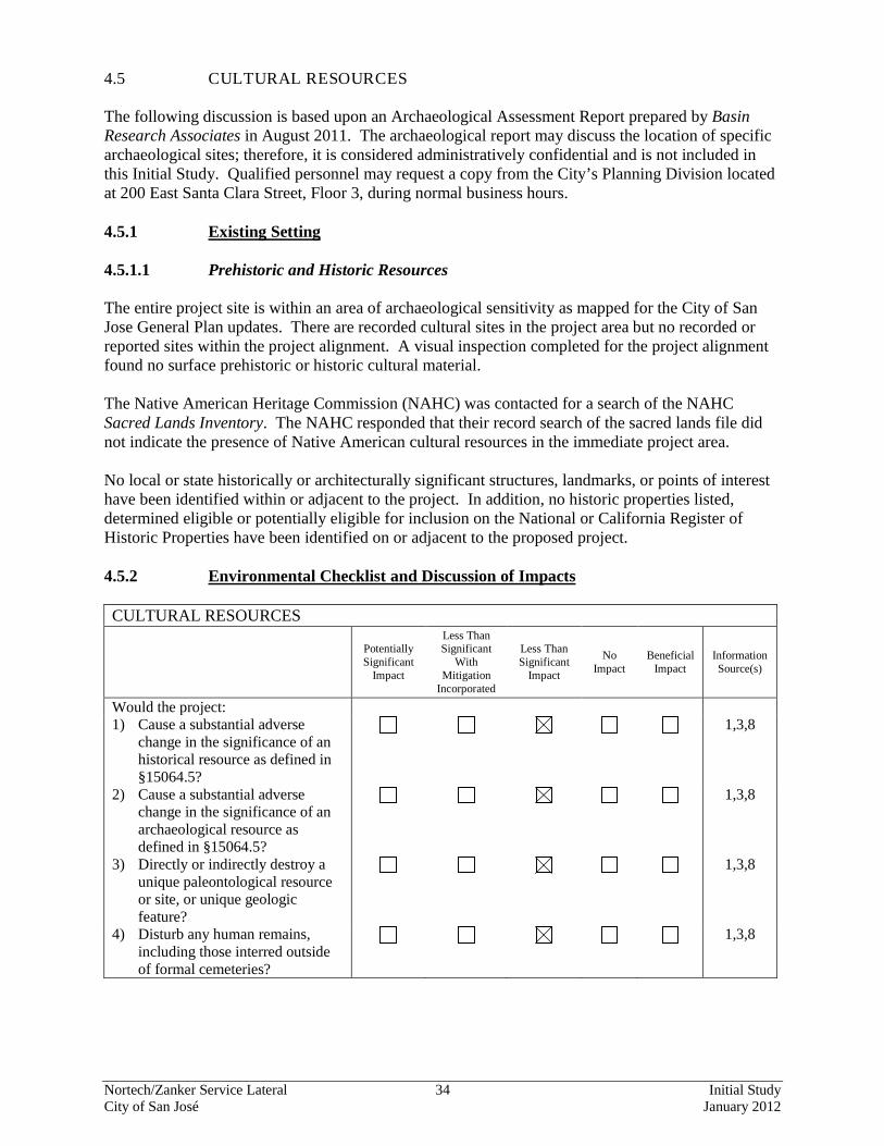
4.5 CULTURAL RESOURCES The following discussion is based upon an Archaeological Assessment Report prepared by Basin Research Associates in August 2011. The archaeological report may discuss the location of specific archaeological sites; therefore, it is considered administratively confidential and is not included in this Initial Study. Qualified personnel may request a copy from the City’s Planning Division located at 200 East Santa Clara Street, Floor 3, during normal business hours. 4.5.1 Existing Setting 4.5.1.1 Prehistoric and Historic Resources The entire project site is within an area of archaeological sensitivity as mapped for the City of San Jose General Plan updates. There are recorded cultural sites in the project area but no recorded or reported sites within the project alignment. A visual inspection completed for the project alignment found no surface prehistoric or historic cultural material. The Native American Heritage Commission (NAHC) was contacted for a search of the NAHC Sacred Lands Inventory. The NAHC responded that their record search of the sacred lands file did not indicate the presence of Native American cultural resources in the immediate project area. No local or state historically or architecturally significant structures, landmarks, or points of interest have been identified within or adjacent to the project. In addition, no historic properties listed, determined eligible or potentially eligible for inclusion on the National or California Register of Historic Properties have been identified on or adjacent to the proposed project. 4.5.2 Environmental Checklist and Discussion of Impacts CULTURAL RESOURCES
Potentially Significant
Impact
Less Than Significant
With Mitigation
Incorporated
Less Than Significant
Impact
No Impact
Beneficial Impact
Information Source(s)
Would the project: 1) Cause a substantial adverse
change in the significance of an historical resource as defined in §15064.5?
1,3,8
2) Cause a substantial adverse change in the significance of an archaeological resource as defined in §15064.5?
1,3,8
3) Directly or indirectly destroy a unique paleontological resource or site, or unique geologic feature?
1,3,8
4) Disturb any human remains, including those interred outside of formal cemeteries?
1,3,8
Nortech/Zanker Service Lateral 35 Initial Study City of San José January 2012
4.5.2.1 Prehistoric and Historic Resources No evidence of Native American use and/or occupation was noted in the project area and no recorded historic and/or prehistoric archaeological sites are located within or adjacent of the project site. Installation of the proposed water service lateral on the project site is not anticipated to affect prehistoric and/or historic archaeological resources. A program of archaeological subsurface presence/absence testing is not necessary and no archaeological monitoring is required during installation of the project. (Less than Significant Impact) Standard Measures which apply to all projects: The following standard measures are included in the project to avoid impacts in the event prehistoric resources are unexpectedly encountered during excavation or installation construction activities.
• Should evidence of prehistoric cultural resources be discovered during installation, work within 50 feet of the find shall be stopped to allow adequate time for evaluation and mitigation by a qualified professional archaeologist. The material shall be evaluated and if significant, a mitigation program including collection and analysis of the materials at a recognized storage facility shall be developed by a qualified archaeologist and implemented under the direction of the City’s Director of Planning, Building and Code Enforcement.
• As required by County ordinance, this project has incorporated the following guidelines: Pursuant to Section 7050.5 of the Health and Safety Code, and Section 5097.94 of the Public Resources Code of the State of California in the event of the discovery of human remains during installation, there shall be no further excavation or disturbance of the site or any nearby area reasonably suspected to overlie adjacent remains. The Santa Clara County Coroner shall be notified and shall make a determination as to whether the remains are Native American. If the Coroner determines that the remains are not subject to his authority, he shall notify the Native American Heritage Commission who shall attempt to identify descendants of the deceased Native American. If no satisfactory agreement can be reached as to the disposition of the remains pursuant to this State law, then the City of San Jose, as land owner, shall re-inter the human remains and items associated with Native American burials on the property in a location not subject to further subsurface disturbance.
4.5.3 Conclusion The propose project would not result in significant cultural resources impacts. (Less Than Significant Impact)
Nortech/Zanker Service Lateral 36 Initial Study City of San José January 2012
4.6 GEOLOGY AND SOILS 4.6.1 Existing Setting The project site is located at the southern end of the San Francisco Bay where the bay margin meets the northwest-trending Santa Clara Valley. The entire project area is on recent alluvium that overlies Pleistocene Older alluvium. This alluvium is largely derived from and is overlying the Miocene marine sandstones and shales which form the hills to the east. The San Francisco Bay region is dominated by strike-slip faulting associated with the San Andreas Fault system. The major active components of the San Andreas Fault system near the site are the Hayward Fault (five miles east), the Calaveras Fault (seven miles east), and the San Andreas Fault (15 miles west). The inferred trace of the potentially active Silver Creek Fault is about a half mile southwest of the site. Seismic hazards resulting from a nearby moderate to major earthquake may include ground shaking, liquefaction, and lateral spreading. Since there are no known active faults crossing the site, fault ground rupture is considered unlikely. The project site is located in an area having high to moderate liquefaction susceptibility and is subject to settlement. 4.6.2 Environmental Checklist and Discussion of Impacts GEOLOGY AND SOILS
Potentially Significant
Impact
Less Than Significant
With Mitigation
Incorporated
Less Than Significant
Impact
No Impact
Beneficial Impact
Information Source(s)
Would the project: 1) Expose people or structures to
potential substantial adverse effects, including the risk of loss, injury, or death involving: a) Rupture of a known earthquake
fault, as described on the most recent Alquist-Priolo Earthquake Fault Zoning Map issued by the State Geologist for the area or based on other substantial evidence of a known fault? (Refer to Division of Mines and Geology Special Publication 42.)
1,9
b) Strong seismic ground shaking? 1,9 c) Seismic-related ground failure,
including liquefaction? 1,9
d) Landslides? 1,9 2) Result in substantial soil erosion or
the loss of topsoil? 1,9
3) Be located on a geologic unit or soil that is unstable, or that will become unstable as a result of the project, and potentially result in on- or off-site landslide, lateral spreading, subsidence, liquefaction or collapse?
1,9
Nortech/Zanker Service Lateral 37 Initial Study City of San José January 2012
GEOLOGY AND SOILS
Potentially Significant
Impact
Less Than Significant
With Mitigation
Incorporated
Less Than Significant
Impact
No Impact
Beneficial Impact
Information Source(s)
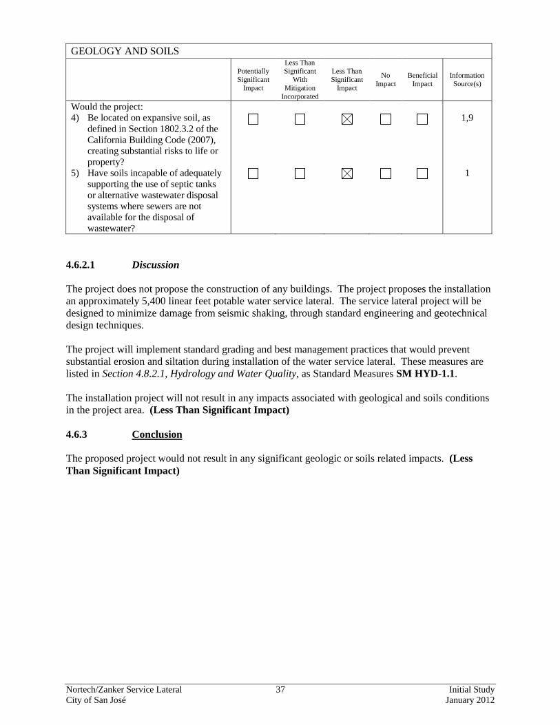
Would the project: 4) Be located on expansive soil, as
defined in Section 1802.3.2 of the California Building Code (2007), creating substantial risks to life or property?
1,9
5) Have soils incapable of adequately supporting the use of septic tanks or alternative wastewater disposal systems where sewers are not available for the disposal of wastewater?
1
4.6.2.1 Discussion The project does not propose the construction of any buildings. The project proposes the installation an approximately 5,400 linear feet potable water service lateral. The service lateral project will be designed to minimize damage from seismic shaking, through standard engineering and geotechnical design techniques. The project will implement standard grading and best management practices that would prevent substantial erosion and siltation during installation of the water service lateral. These measures are listed in Section 4.8.2.1, Hydrology and Water Quality, as Standard Measures SM HYD-1.1. The installation project will not result in any impacts associated with geological and soils conditions in the project area. (Less Than Significant Impact) 4.6.3 Conclusion The proposed project would not result in any significant geologic or soils related impacts. (Less Than Significant Impact)
Nortech/Zanker Service Lateral 38 Initial Study City of San José January 2012
4.7 GREENHOUSE GAS EMISSIONS 4.7.1 Existing Setting Unlike emissions of criteria and toxic air pollutants, which have local or regional impacts, emissions of Greenhouse Gases (GHGs) have a broader, global impact. Global warming is a process whereby GHGs accumulating in the atmosphere contribute to an increase in the temperature of the earth’s atmosphere. The principal GHGs contributing to global warming are carbon dioxide (CO2), methane (CH4), nitrous oxide (N2O), and fluorinated compounds. Emissions of GHGs contributing to global climate change are attributable in large part to human activities associated with the transportation, industrial/manufacturing, utility, residential, commercial, and agricultural sectors. In September 2006, Governor Schwarzenegger signed the Global Warming Solutions Act (Assembly Bill 32), which was created to address the Global Warming situation in California. The Act requires that the greenhouse gas (GHG) emissions in California be reduced to 1990 levels by 2020. This is part of a larger plan in which California hopes to reduce its emissions to 80 percent below 1990 levels by 2050. This reduction shall be accomplished through an enforceable statewide cap on GHG emissions that shall be phased in starting in 2012 and regulated by the California Air Resources Board (CARB). With this Act in place, CARB is in charge of setting specific standards for different source emissions, as well as monitoring whether they are being met. The project site is located in the area under the jurisdiction of the Bay Area Air Quality Management District (BAAQMD). BAAQMD is responsible for adopting and enforcing rules and regulations concerning air pollutant sources, issuing permits for stationary sources of air pollutant, inspecting stationary sources of air pollutants, responding to citizen complaints, monitoring ambient air quality and meteorological conditions, awarding grants to reduce motor vehicle emissions, completing public education campaigns, and many other associated activities. BAAQMD adopted CEQA Guidelines in June 2010 (updated in May 2011) which are intended to serve as a guide for those who prepare or evaluate air quality impact analyses for projects and plans in the San Francisco Bay Area. The Guidelines include information on legal requirements, BAAQMD rules, plans and procedures, background air quality information, methods of analyzing air quality impacts, thresholds of significance, and mitigation strategies for criteria pollutants, air toxics, odors, and greenhouse gas emissions.
Nortech/Zanker Service Lateral 39 Initial Study City of San José January 2012
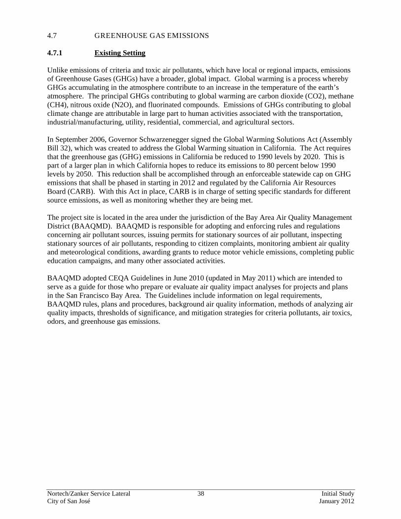
4.7.2 Environmental Checklist and Discussion of Impacts GREENHOUSE GAS EMISSIONS
Potentially Significant
Impact
Less Than Significant
With Mitigation
Incorporated
Less Than Significant
Impact
No Impact
Beneficial Impact
Information Source(s)
Would the project: 1) Generate greenhouse gas
emissions, either directly or indirectly, that may have a significant impact on the environment?
1,6
2) Conflict with an applicable plan, policy or regulation adopted for the purpose of reducing the emissions of greenhouse gases?
1,6
4.7.2.1 Discussion The proposed project would result in minor temporary increases in GHGs associated with construction activities. Project construction shall result in GHG emissions from the following construction related sources: (1) construction equipment emissions; and (2) emissions from the personal vehicles of construction workers traveling to and from the construction site. Construction-related GHG emissions vary depending on the level of activity, length of the construction period, specific construction operations, types of equipment, and number of personnel. BAAQMD has not established a quantitative threshold or standard for determining whether a project's construction-related GHG emissions are significant. Construction GHG emissions would be intermittent and substantially less than the lower reporting limit for major stationary sources established by the CARB. That reporting limit requires sources that generate more than 25,000 metric tons per year of CO2 to report GHG emissions to CARB. Consequently, project construction would not have a significant impact on the environment. Therefore, this impact would be less than significant. The proposed project would not conflict with any existing GHG laws, plans, policies, or regulations adopted by the California legislature, the CARB, or BAAQMD. Therefore, the project would have a less than significant impact on greenhouse gas emissions. (Less Than Significant Impact) 4.7.3 Conclusion The proposed project would not result in any significant greenhouse gas-related effects. (Less Than Significant Impact)
Nortech/Zanker Service Lateral 40 Initial Study City of San José January 2012
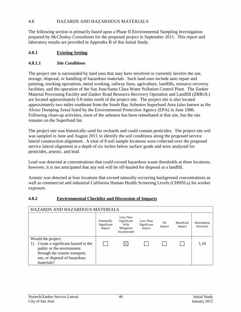
4.8 HAZARDS AND HAZARDOUS MATERIALS The following section is primarily based upon a Phase II Environmental Sampling Investigation prepared by McCloskey Consultants for the proposed project in September 2011. This report and laboratory results are provided in Appendix B of this Initial Study. 4.8.1 Existing Setting 4.8.1.1 Site Conditions The project site is surrounded by land uses that may have involved or currently involve the use, storage, disposal, or handling of hazardous materials. Such land uses include auto repair and painting, trucking operations, metal working, railway lines, agriculture, landfills, resource recovery facilities, and the operation of the San Jose/Santa Clara Water Pollution Control Plant. The Zanker Material Processing Facility and Zanker Road Resource Recovery Operation and Landfill (ZRROL) are located approximately 0.8 miles north of the project site. The project site is also located approximately two miles southeast from the South Bay Asbestos Superfund Area (also known as the Alviso Dumping Area) listed by the Environmental Protection Agency (EPA) in June 1986. Following clean-up activities, most of the asbestos has been remediated at that site, but the site remains on the Superfund list. The project site was historically used for orchards and could contain pesticides. The project site soil was sampled in June and August 2011 to identify the soil conditions along the proposed service lateral construction alignment. A total of 8 soil sample locations were collected over the proposed service lateral alignment at a depth of six inches below surface grade and were analyzed for pesticides, arsenic, and lead. Lead was detected at concentrations that could exceed hazardous waste thresholds at three locations, however, it is not anticipated that any soil will be off-hauled for disposal at a landfill. Arsenic was detected at four locations that exceed naturally-occurring background concentrations as well as commercial and industrial California Human Health Screening Levels (CHHSLs) for worker exposure. 4.8.2 Environmental Checklist and Discussion of Impacts HAZARDS AND HAZARDOUS MATERIALS
Potentially Significant
Impact
Less Than Significant
With Mitigation
Incorporated
Less Than Significant
Impact
No Impact
Beneficial Impact
Information Source(s)
Would the project: 1) Create a significant hazard to the
public or the environment through the routine transport, use, or disposal of hazardous materials?
1,10
Nortech/Zanker Service Lateral 41 Initial Study City of San José January 2012
HAZARDS AND HAZARDOUS MATERIALS
Potentially Significant
Impact
Less Than Significant
With Mitigation
Incorporated
Less Than Significant
Impact
No Impact
Beneficial Impact
Information Source(s)
Would the project: 2) Create a significant hazard to the
public or the environment through reasonably foreseeable upset and accident conditions involving the release of hazardous materials into the environment?
1,10
3) Emit hazardous emissions or handle hazardous or acutely hazardous materials, substances, or waste within one-quarter mile of an existing or proposed school?
1,10
4) Be located on a site which is included on a list of hazardous materials sites compiled pursuant to Government Code Section 65962.5 and, as a result, would it create a significant hazard to the public or the environment?
1,10
5) For a project located within an airport land use plan or, where such a plan has not been adopted, within two miles of a public airport or public use airport, would the project result in a safety hazard for people residing or working in the project area?
1
6) For a project within the vicinity of a private airstrip, would the project result in a safety hazard for people residing or working in the project area?
1
7) Impair implementation of, or physically interfere with, an adopted emergency response plan or emergency evacuation plan?
1,3
8) Expose people or structures to a significant risk of loss, injury or death involving wildland fires, including where wildlands are adjacent to urbanized areas or where residences are intermixed with wildlands?
1,3
Nortech/Zanker Service Lateral 42 Initial Study City of San José January 2012
4.8.2.1 Discussion Operation of the project would not involve the routine transportation, use, storage, and/or disposal of hazardous materials. Construction of the project however, could temporarily increase the transport of materials, generally regarded as hazardous, that are used in construction activities. It is anticipated that limited quantities of miscellaneous hazardous substances, such as gasoline, diesel fuel, hydraulic fluids, paint, and other similarly related materials would be brought onto the project site, used, and stored during the construction period. The types and quantities of materials to be used are unlikely to pose a significant risk to the public and/or the environment.
Arsenic Contaminated Soils
Arsenic was detected at concentrations that exceed commercial and industrial CHHSLs for worker exposure. Construction of the proposed project could result in the exposure of construction workers to potentially contaminated surface soils due to the elevated concentrations of arsenic. Impact HAZ-1.1: Construction of the proposed project could result in the exposure of
construction workers to potentially contaminated surface soils due to the elevated concentrations of arsenic. (Significant Impact)
To protect workers from the elevated concentrations of arsenic in these soils, health and safety measures will be implemented to protect workers from exposure during construction. MM HAZ-1.1: The project would include the following mitigation measures to reduce the
risk of hazard to human beings or the environment through the routine transport, use, or disposal of hazardous materials:
• Site Management Plan. Health and safety measures in the form of a
Health and Safety Plan will be implemented to protect workers from exposure to contaminated surface soils during construction. Under OSHA requirements, workers will receive 2-hours of health and safety awareness training4
• Standard Measure HAZ-1.1: Store, Handle, Use Hazardous Materials in Accordance with Applicable Laws. The contractor shall ensure that all construction-related hazardous materials and hazardous wastes shall be stored, handled, and used in a manner consistent with relevant and applicable federal, state, and local laws. In addition, construction-related hazardous materials and hazardous wastes shall be staged and stored a safe distance from near-by property and proper dust control measures are required.
and personal protection equipment will be worn by workers (e.g. tyvek suit, rubber boots, decon, etc.), and a washing facility will be provided on site. Upper soils will be stockpiled separately and covered during service lateral installation, then put back in the trench to reduce exposure. The project applicant shall submit the Health and Safety Plan and it shall be prepared to the satisfaction of the City’s Director of Planning, Building and Code Enforcement prior to the start of ground disturbing activities.
4 If the workers have already completed 40-hours of hazardous worker training, then they would not need to do the 2 hour training.
Nortech/Zanker Service Lateral 43 Initial Study City of San José January 2012
Lead Contaminated Soils As mentioned previously, lead was detected at concentrations that exceed hazardous waste thresholds. This is not a health and safety issue unless the soils are off-hauled for disposal at a landfill, which this project does not propose. All such soils will be backfilled on-site. Impact HAZ-2.1: Construction of the proposed project could result in the disposal of hazardous
waste at a landfill due to the elevated concentrations of lead. (Significant Impact)
The following mitigation measures will be implemented during construction. MM HAZ-2.1: The project would include the following mitigation measures to reduce the
risk of hazard to human beings or the environment through the routine transport, use, or disposal of hazardous materials:
• All excavated lead-containing soils shall be stockpiled separately and
covered during construction. The soils shall then be backfilled into the trench to reduce the potential for disposal of hazardous waste at a landfill. As mentioned previously, it is not anticipated that any soils will leave the site.
The proposed project would not involve a permanent use or source of hazardous materials. Therefore, there are no reasonably foreseeable upset and/or accident conditions that would involve the release of hazardous materials into the environment. (Less Than Significant Impact) The closest school is George Mayne Elementary School which is 0.7 mile west of the project site. The proposed project would not emit hazardous emissions or result in the handling of hazardous materials, substances, or waste that would impact this elementary school. (No Impact) The project is not located on a site which is known to be included on a list of hazardous materials sites compiled pursuant to Government Code Section 65962.5 and therefore would not create a significant hazard to the public or the environment. (No Impact) The project site is not located within the Santa Clara County Airport Land Use Commission’s jurisdiction. The proposed project site is not located within two miles of any public airports or private airstrips. Further, construction and/or operation of the proposed project would not adversely affect an airport or airport operations, including noise, take-offs, landings, flight patterns, safety, light, navigation, or communications between aircraft and the control tower within the project area. The proposed project would not create a safety hazard for people residing or working near an airport or airstrip. (No Impact) The proposed project would not impair implementation of or physically interfere with an adopted emergency response plan or emergency evacuation plan. (No Impact) According to the Santa Clara County Fire Hazard Severity Zone Map, dated February 4, 2009, the project site is not located within a wildland area and is not assigned a fire hazard severity zoning. (No Impact)
Nortech/Zanker Service Lateral 44 Initial Study City of San José January 2012
4.8.3 Conclusion Implementation of the mitigation measures listed above will avoid impacts from hazardous materials associated with construction of the proposed project (Less Than Significant Impact with Mitigation)
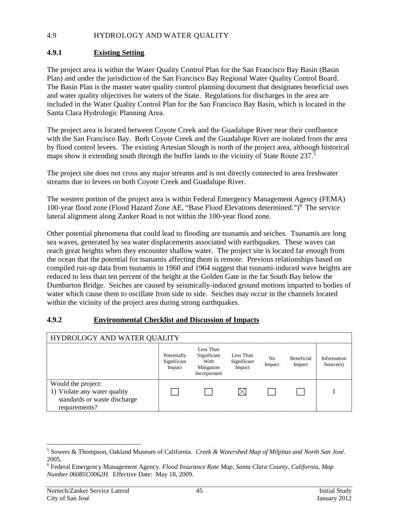
Nortech/Zanker Service Lateral 45 Initial Study City of San José January 2012
4.9 HYDROLOGY AND WATER QUALITY 4.9.1 Existing Setting The project area is within the Water Quality Control Plan for the San Francisco Bay Basin (Basin Plan) and under the jurisdiction of the San Francisco Bay Regional Water Quality Control Board. The Basin Plan is the master water quality control planning document that designates beneficial uses and water quality objectives for waters of the State. Regulations for discharges in the area are included in the Water Quality Control Plan for the San Francisco Bay Basin, which is located in the Santa Clara Hydrologic Planning Area. The project area is located between Coyote Creek and the Guadalupe River near their confluence with the San Francisco Bay. Both Coyote Creek and the Guadalupe River are isolated from the area by flood control levees. The existing Artesian Slough is north of the project area, although historical maps show it extending south through the buffer lands to the vicinity of State Route 237.5
The project site does not cross any major streams and is not directly connected to area freshwater streams due to levees on both Coyote Creek and Guadalupe River. The western portion of the project area is within Federal Emergency Management Agency (FEMA) 100-year flood zone (Flood Hazard Zone AE, “Base Flood Elevations determined.”)6
The service lateral alignment along Zanker Road is not within the 100-year flood zone.
Other potential phenomena that could lead to flooding are tsunamis and seiches. Tsunamis are long sea waves, generated by sea water displacements associated with earthquakes. These waves can reach great heights when they encounter shallow water. The project site is located far enough from the ocean that the potential for tsunamis affecting them is remote. Previous relationships based on compiled run-up data from tsunamis in 1960 and 1964 suggest that tsunami-induced wave heights are reduced to less than ten percent of the height at the Golden Gate in the far South Bay below the Dumbarton Bridge. Seiches are caused by seismically-induced ground motions imparted to bodies of water which cause them to oscillate from side to side. Seiches may occur in the channels located within the vicinity of the project area during strong earthquakes. 4.9.2 Environmental Checklist and Discussion of Impacts HYDROLOGY AND WATER QUALITY
Potentially Significant
Impact
Less Than Significant
With Mitigation
Incorporated
Less Than Significant
Impact
No Impact
Beneficial Impact
Information Source(s)
Would the project: 1) Violate any water quality
standards or waste discharge requirements?
1
5 Sowers & Thompson, Oakland Museum of California. Creek & Watershed Map of Milpitas and North San José. 2005. 6 Federal Emergency Management Agency. Flood Insurance Rate Map, Santa Clara County, California, Map Number 06085C0062H. Effective Date: May 18, 2009.
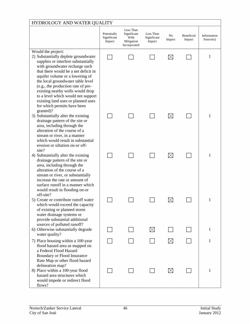
Nortech/Zanker Service Lateral 46 Initial Study City of San José January 2012
HYDROLOGY AND WATER QUALITY
Potentially Significant
Impact
Less Than Significant
With Mitigation
Incorporated
Less Than Significant
Impact
No Impact
Beneficial Impact
Information Source(s)
Would the project: 2) Substantially deplete groundwater
supplies or interfere substantially with groundwater recharge such that there would be a net deficit in aquifer volume or a lowering of the local groundwater table level (e.g., the production rate of pre-existing nearby wells would drop to a level which would not support existing land uses or planned uses for which permits have been granted)?
1
3) Substantially alter the existing drainage pattern of the site or area, including through the alteration of the course of a stream or river, in a manner which would result in substantial erosion or siltation on-or off-site?
1
4) Substantially alter the existing drainage pattern of the site or area, including through the alteration of the course of a stream or river, or substantially increase the rate or amount of surface runoff in a manner which would result in flooding on-or off-site?
1
5) Create or contribute runoff water which would exceed the capacity of existing or planned storm water drainage systems or provide substantial additional sources of polluted runoff?
1
6) Otherwise substantially degrade water quality?
1
7) Place housing within a 100-year flood hazard area as mapped on a Federal Flood Hazard Boundary or Flood Insurance Rate Map or other flood hazard delineation map?
1
8) Place within a 100-year flood hazard area structures which would impede or redirect flood flows?
1
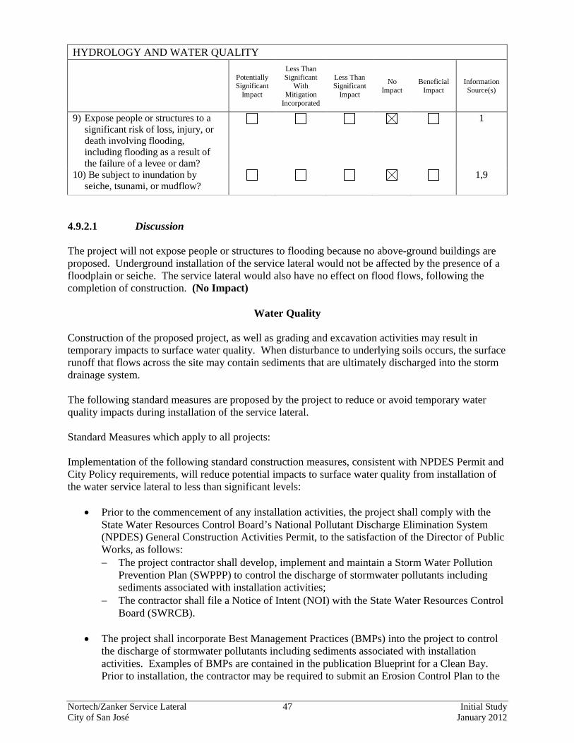
Nortech/Zanker Service Lateral 47 Initial Study City of San José January 2012
HYDROLOGY AND WATER QUALITY
Potentially Significant
Impact
Less Than Significant
With Mitigation
Incorporated
Less Than Significant
Impact
No Impact
Beneficial Impact
Information Source(s)
9) Expose people or structures to a significant risk of loss, injury, or death involving flooding, including flooding as a result of the failure of a levee or dam?
1
10) Be subject to inundation by seiche, tsunami, or mudflow?
1,9
4.9.2.1 Discussion The project will not expose people or structures to flooding because no above-ground buildings are proposed. Underground installation of the service lateral would not be affected by the presence of a floodplain or seiche. The service lateral would also have no effect on flood flows, following the completion of construction. (No Impact)
Water Quality
Construction of the proposed project, as well as grading and excavation activities may result in temporary impacts to surface water quality. When disturbance to underlying soils occurs, the surface runoff that flows across the site may contain sediments that are ultimately discharged into the storm drainage system. The following standard measures are proposed by the project to reduce or avoid temporary water quality impacts during installation of the service lateral. Standard Measures which apply to all projects: Implementation of the following standard construction measures, consistent with NPDES Permit and City Policy requirements, will reduce potential impacts to surface water quality from installation of the water service lateral to less than significant levels:
• Prior to the commencement of any installation activities, the project shall comply with the State Water Resources Control Board’s National Pollutant Discharge Elimination System (NPDES) General Construction Activities Permit, to the satisfaction of the Director of Public Works, as follows: − The project contractor shall develop, implement and maintain a Storm Water Pollution
Prevention Plan (SWPPP) to control the discharge of stormwater pollutants including sediments associated with installation activities;
− The contractor shall file a Notice of Intent (NOI) with the State Water Resources Control Board (SWRCB).
• The project shall incorporate Best Management Practices (BMPs) into the project to control
the discharge of stormwater pollutants including sediments associated with installation activities. Examples of BMPs are contained in the publication Blueprint for a Clean Bay. Prior to installation, the contractor may be required to submit an Erosion Control Plan to the
Nortech/Zanker Service Lateral 48 Initial Study City of San José January 2012
City Project Engineer, Department of Public Works, 200 E. Santa Clara Street, San Jose, California 95113. The Erosion Control Plan may include BMPs as specified in ABAG’s Manual of Standards Erosion & Sediment Control Measures for reducing impacts on the City’s storm drainage system from installation activities. For additional information about the Erosion Control Plan, the NPDES Permit requirements or the documents mentioned above, please call the Department of Public Works at (408) 535-8300.
• The project contractor shall comply with the City of San Jose Grading Ordinance, including erosion and dust control during installation and with the City of San Jose Zoning Ordinance requirements for keeping adjacent streets free of dirt and mud during construction. The following specific BMPs will be implemented to prevent stormwater pollution and minimize potential sedimentation during installation: − Restrict grading to the dry season (April 15 through October 15) or meet City
requirements for grading during the rainy season. − Utilize on-site sediment control BMPs to retain sediment on the project site; − Utilize stabilized construction entrances and/or wash racks; − Implement damp street sweeping; − Provide temporary cover of disturbed surfaces to help control erosion during installation; − Provide permanent cover to stabilize the disturbed surfaces after installation has been
completed. 4.9.3 Conclusion The project would not result in any significant flood or water quality impacts from construction of the proposed project. (Less Than Significant Impact)
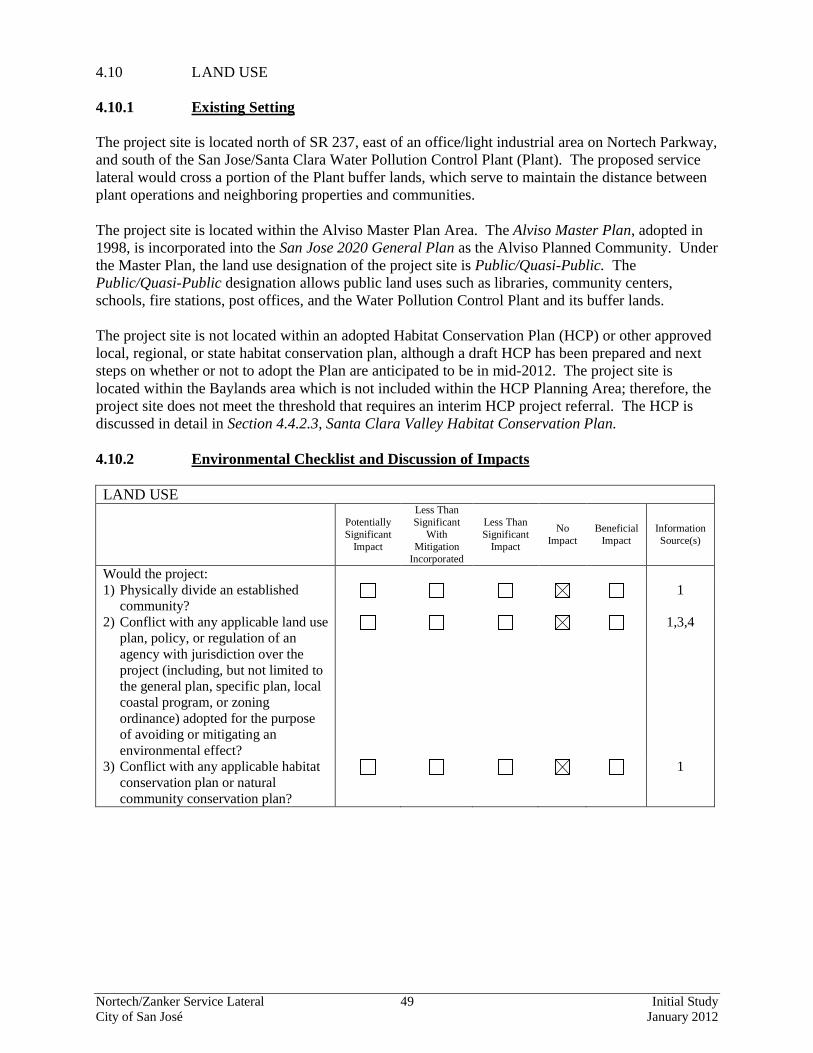
Nortech/Zanker Service Lateral 49 Initial Study City of San José January 2012
4.10 LAND USE 4.10.1 Existing Setting The project site is located north of SR 237, east of an office/light industrial area on Nortech Parkway, and south of the San Jose/Santa Clara Water Pollution Control Plant (Plant). The proposed service lateral would cross a portion of the Plant buffer lands, which serve to maintain the distance between plant operations and neighboring properties and communities. The project site is located within the Alviso Master Plan Area. The Alviso Master Plan, adopted in 1998, is incorporated into the San Jose 2020 General Plan as the Alviso Planned Community. Under the Master Plan, the land use designation of the project site is Public/Quasi-Public. The Public/Quasi-Public designation allows public land uses such as libraries, community centers, schools, fire stations, post offices, and the Water Pollution Control Plant and its buffer lands. The project site is not located within an adopted Habitat Conservation Plan (HCP) or other approved local, regional, or state habitat conservation plan, although a draft HCP has been prepared and next steps on whether or not to adopt the Plan are anticipated to be in mid-2012. The project site is located within the Baylands area which is not included within the HCP Planning Area; therefore, the project site does not meet the threshold that requires an interim HCP project referral. The HCP is discussed in detail in Section 4.4.2.3, Santa Clara Valley Habitat Conservation Plan. 4.10.2 Environmental Checklist and Discussion of Impacts LAND USE
Potentially Significant
Impact
Less Than Significant
With Mitigation
Incorporated
Less Than Significant
Impact
No Impact
Beneficial Impact
Information Source(s)
Would the project: 1) Physically divide an established
community? 1
2) Conflict with any applicable land use plan, policy, or regulation of an agency with jurisdiction over the project (including, but not limited to the general plan, specific plan, local coastal program, or zoning ordinance) adopted for the purpose of avoiding or mitigating an environmental effect?
1,3,4
3) Conflict with any applicable habitat conservation plan or natural community conservation plan?
1
Nortech/Zanker Service Lateral 50 Initial Study City of San José January 2012
4.10.2.1 Discussion The project is the installation of a potable water service lateral to provide a backup potable water supply to the ARWTF during unanticipated system or operation disruptions related to loss of power supply or necessary maintenance. If the ARWTF recycled water pumps fail then the facility could switch the outflow to the proposed potable water supply in order to maintain water service reliability and water quality for the City’s recycled water customers. The potable water supply will remain unused until there is a need related to an interruption or maintenance. The service lateral will be connected to the San Jose Municipal Water System, which is the local water retailer. The new service lateral will be a part of the San Jose MWS’s overall potable network and the new service lateral will be owned by the Plant. The proposed project would be compatible with the adjacent land uses and would not divide an established community or result in any new significant land use impacts since no other land use development of the site is proposed. (No Impact) 4.10.3 Conclusion There would be no significant land use impacts from the proposed project. (No Impact)
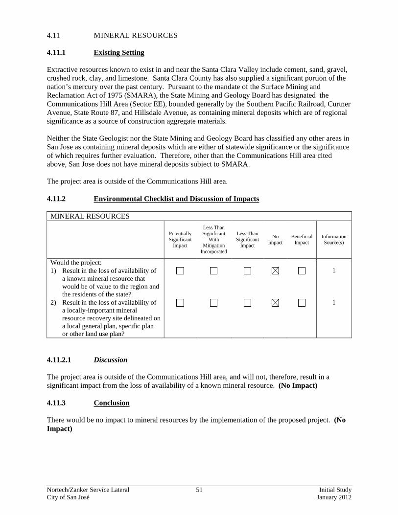
Nortech/Zanker Service Lateral 51 Initial Study City of San José January 2012
4.11 MINERAL RESOURCES 4.11.1 Existing Setting Extractive resources known to exist in and near the Santa Clara Valley include cement, sand, gravel, crushed rock, clay, and limestone. Santa Clara County has also supplied a significant portion of the nation’s mercury over the past century. Pursuant to the mandate of the Surface Mining and Reclamation Act of 1975 (SMARA), the State Mining and Geology Board has designated the Communications Hill Area (Sector EE), bounded generally by the Southern Pacific Railroad, Curtner Avenue, State Route 87, and Hillsdale Avenue, as containing mineral deposits which are of regional significance as a source of construction aggregate materials. Neither the State Geologist nor the State Mining and Geology Board has classified any other areas in San Jose as containing mineral deposits which are either of statewide significance or the significance of which requires further evaluation. Therefore, other than the Communications Hill area cited above, San Jose does not have mineral deposits subject to SMARA. The project area is outside of the Communications Hill area. 4.11.2 Environmental Checklist and Discussion of Impacts MINERAL RESOURCES
Potentially Significant
Impact
Less Than Significant
With Mitigation
Incorporated
Less Than Significant
Impact
No Impact
Beneficial Impact
Information Source(s)
Would the project: 1) Result in the loss of availability of
a known mineral resource that would be of value to the region and the residents of the state?
1
2) Result in the loss of availability of a locally-important mineral resource recovery site delineated on a local general plan, specific plan or other land use plan?
1
4.11.2.1 Discussion The project area is outside of the Communications Hill area, and will not, therefore, result in a significant impact from the loss of availability of a known mineral resource. (No Impact) 4.11.3 Conclusion There would be no impact to mineral resources by the implementation of the proposed project. (No Impact)
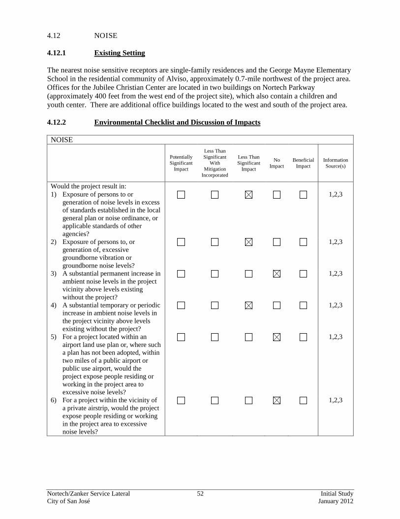
Nortech/Zanker Service Lateral 52 Initial Study City of San José January 2012
4.12 NOISE 4.12.1 Existing Setting The nearest noise sensitive receptors are single-family residences and the George Mayne Elementary School in the residential community of Alviso, approximately 0.7-mile northwest of the project area. Offices for the Jubilee Christian Center are located in two buildings on Nortech Parkway (approximately 400 feet from the west end of the project site), which also contain a children and youth center. There are additional office buildings located to the west and south of the project area. 4.12.2 Environmental Checklist and Discussion of Impacts NOISE
Potentially Significant
Impact
Less Than Significant
With Mitigation
Incorporated
Less Than Significant
Impact
No Impact
Beneficial Impact
Information Source(s)
Would the project result in: 1) Exposure of persons to or
generation of noise levels in excess of standards established in the local general plan or noise ordinance, or applicable standards of other agencies?
1,2,3
2) Exposure of persons to, or generation of, excessive groundborne vibration or groundborne noise levels?
1,2,3
3) A substantial permanent increase in ambient noise levels in the project vicinity above levels existing without the project?
1,2,3
4) A substantial temporary or periodic increase in ambient noise levels in the project vicinity above levels existing without the project?
1,2,3
5) For a project located within an airport land use plan or, where such a plan has not been adopted, within two miles of a public airport or public use airport, would the project expose people residing or working in the project area to excessive noise levels?
1,2,3
6) For a project within the vicinity of a private airstrip, would the project expose people residing or working in the project area to excessive noise levels?
1,2,3
Nortech/Zanker Service Lateral 53 Initial Study City of San José January 2012
4.12.2.1 Noise Impacts to the Project The project proposes a potable service lateral; no future development is proposed as a part of this project. Therefore, no new long-term noise impacts would occur from the project. (No Impact) 4.12.2.2 Noise Impacts from the Project Noise would be generated during excavation, installation, and cut and fill activities in the project area. Based upon the distance from the project area to the closest sensitive receptor (0.7-mile), excavation and installation would not significantly impact these receptors. While there is not a significant noise impact, the project will include standard construction noise control measures to further reduce any short-term noise impact from excavation and installation activities. Standard Measures which apply to all projects: The following measures will be implemented by the project during excavation and installation to reduce noise impacts to nearby sensitive receptors:
• Excavation and installation activities will be limited to the hours of 7:00 a.m. to 7:00 p.m. Monday through Friday.
• The contractor shall use “new technology” equipment with state-of-the-art noise shielding and muffling devices. All internal combustion engines used on the project site shall be equipped with adequate mufflers and shall be in good mechanical condition to minimize noise created by faulty or poor maintained engines or other components.
4.12.3 Conclusion The proposed project would not result in significant noise impacts associated with installation of the water service lateral. (Less Than Significant Impact)
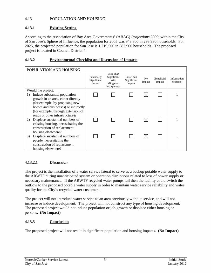
Nortech/Zanker Service Lateral 54 Initial Study City of San José January 2012
4.13 POPULATION AND HOUSING 4.13.1 Existing Setting According to the Association of Bay Area Governments’ (ABAG) Projections 2009, within the City of San Jose’s Sphere of Influence, the population for 2005 was 943,300 in 293,930 households. For 2025, the projected population for San Jose is 1,219,500 in 382,900 households. The proposed project is located in Council District 4. 4.13.2 Environmental Checklist and Discussion of Impacts POPULATION AND HOUSING
Potentially Significant
Impact
Less Than Significant
With Mitigation
Incorporated
Less Than Significant
Impact
No Impact
Beneficial Impact
Information Source(s)
Would the project: 1) Induce substantial population
growth in an area, either directly (for example, by proposing new homes and businesses) or indirectly (for example, through extension of roads or other infrastructure)?
1
2) Displace substantial numbers of existing housing, necessitating the construction of replacement housing elsewhere?
1
3) Displace substantial numbers of people, necessitating the construction of replacement housing elsewhere?
1
4.13.2.1 Discussion The project is the installation of a water service lateral to serve as a backup potable water supply to the ARWTF during unanticipated system or operation disruptions related to loss of power supply or necessary maintenance. If the ARWTF recycled water pumps fail then the facility could switch the outflow to the proposed potable water supply in order to maintain water service reliability and water quality for the City’s recycled water customers. The project will not introduce water service to an area previously without service, and will not increase or induce development. The project will not construct any type of housing development. The proposed project would not induce population or job growth or displace either housing or persons. (No Impact) 4.13.3 Conclusion The proposed project will not result in significant population and housing impacts. (No Impact)
Nortech/Zanker Service Lateral 55 Initial Study City of San José January 2012
4.14 PUBLIC SERVICES 4.14.1.1 Fire Service Fire protection to the site is provided by the San Jose Fire Department (SJFD), which serves a total area of 203 square miles. The SJFD responds to all fires, hazardous materials spills, and medical emergencies (including injury accidents) in the project area. The SJFD currently has 35 fire stations located throughout the City. The closest station to the project site is Station 25, approximately one mile west of the project area, located at 1525 Wilson Way. 4.14.1.2 Police Service Police protection services for the site are provided by the San Jose Police Department (SJPD). Officers patrolling the project area are dispatched from police headquarters located at 201 West Mission Street. The SJPD consists of approximately 1,390 sworn officers and 341 marked police cars.7
The SJPD has four patrol divisions (plus San Jose Airport), 16 patrol districts, 83 patrol beats, and 357 patrol beat building blocks (BBB). The project site is located in the BBB 42. 4.14.1.3 Schools The closest schools to the proposed project include George Mayne Elementary School, Peterson Middle School, and Wilcox High School. 4.14.1.4 Parks Existing parks and recreation facilities in the Alviso area include the 7.5 acre Alviso Park adjacent to George Mayne Elementary School, and an 800 square foot community center on Liberty Street. Regional facilities in the area include the Don Edwards San Francisco Bay National Wildlife Refuge, which has 3,652 acres within the San Jose Sphere of Influence (19,058 acres total), and the Alviso Marina County Park (approximately 28 acres total). The Water Pollution Control Plant buffer lands also provide additional open space within the City of San Jose, although the buffer lands are not open to the general public.
7 Sergeant Christopher Monahan, Office of the Chief of Police, San José Police Department. Personal communication. February 27, 2009.
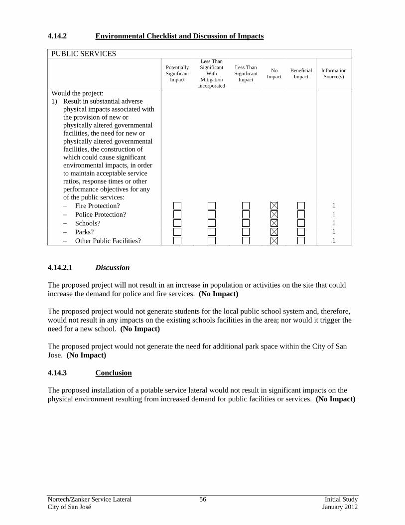
Nortech/Zanker Service Lateral 56 Initial Study City of San José January 2012
4.14.2 Environmental Checklist and Discussion of Impacts PUBLIC SERVICES
Potentially Significant
Impact
Less Than Significant
With Mitigation
Incorporated
Less Than Significant
Impact
No Impact
Beneficial Impact
Information Source(s)
Would the project: 1) Result in substantial adverse
physical impacts associated with the provision of new or physically altered governmental facilities, the need for new or physically altered governmental facilities, the construction of which could cause significant environmental impacts, in order to maintain acceptable service ratios, response times or other performance objectives for any of the public services:
− Fire Protection? 1 − Police Protection? 1 − Schools? 1 − Parks? 1 − Other Public Facilities? 1
4.14.2.1 Discussion The proposed project will not result in an increase in population or activities on the site that could increase the demand for police and fire services. (No Impact) The proposed project would not generate students for the local public school system and, therefore, would not result in any impacts on the existing schools facilities in the area; nor would it trigger the need for a new school. (No Impact) The proposed project would not generate the need for additional park space within the City of San Jose. (No Impact) 4.14.3 Conclusion The proposed installation of a potable service lateral would not result in significant impacts on the physical environment resulting from increased demand for public facilities or services. (No Impact)
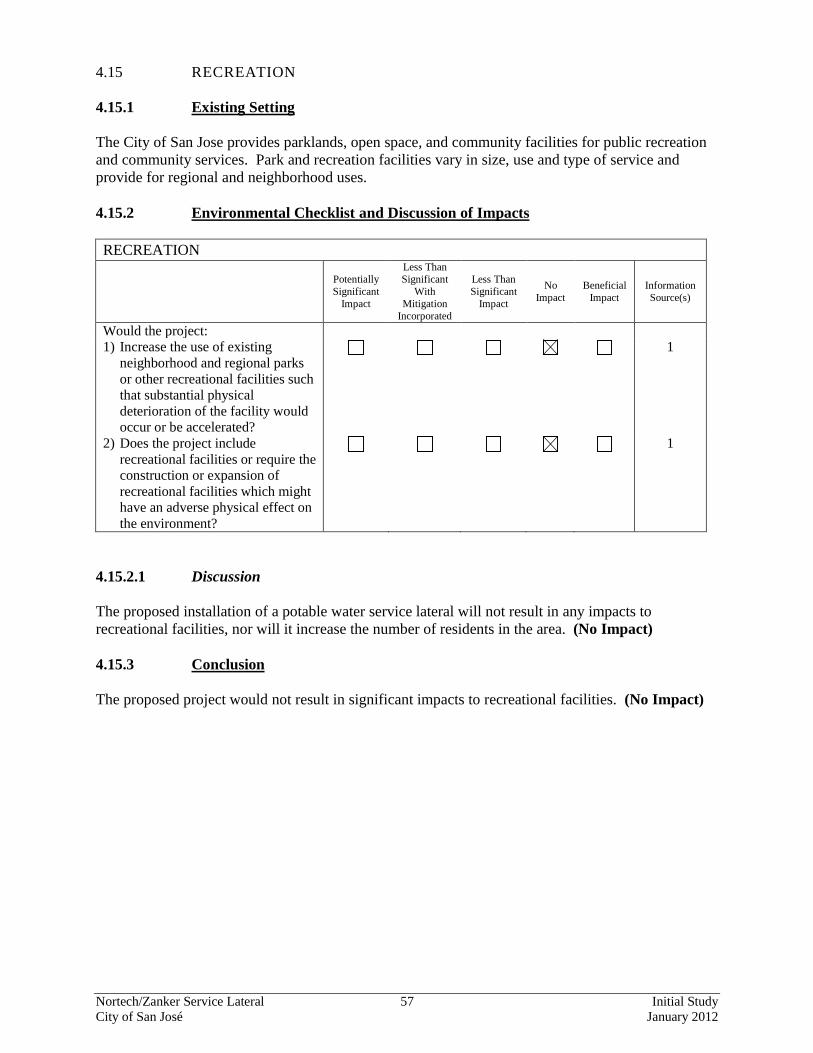
Nortech/Zanker Service Lateral 57 Initial Study City of San José January 2012
4.15 RECREATION 4.15.1 Existing Setting The City of San Jose provides parklands, open space, and community facilities for public recreation and community services. Park and recreation facilities vary in size, use and type of service and provide for regional and neighborhood uses. 4.15.2 Environmental Checklist and Discussion of Impacts RECREATION
Potentially Significant
Impact
Less Than Significant
With Mitigation
Incorporated
Less Than Significant
Impact
No Impact
Beneficial Impact
Information Source(s)
Would the project: 1) Increase the use of existing
neighborhood and regional parks or other recreational facilities such that substantial physical deterioration of the facility would occur or be accelerated?
1
2) Does the project include recreational facilities or require the construction or expansion of recreational facilities which might have an adverse physical effect on the environment?
1
4.15.2.1 Discussion The proposed installation of a potable water service lateral will not result in any impacts to recreational facilities, nor will it increase the number of residents in the area. (No Impact) 4.15.3 Conclusion The proposed project would not result in significant impacts to recreational facilities. (No Impact)
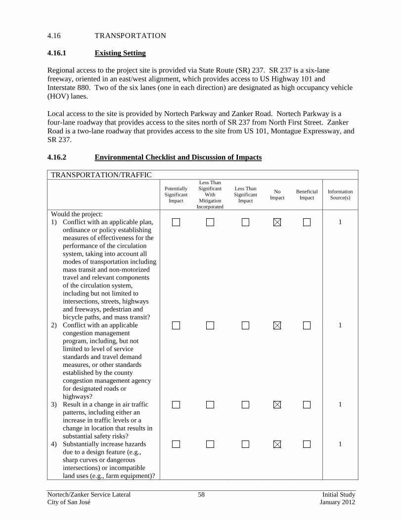
Nortech/Zanker Service Lateral 58 Initial Study City of San José January 2012
4.16 TRANSPORTATION 4.16.1 Existing Setting Regional access to the project site is provided via State Route (SR) 237. SR 237 is a six-lane freeway, oriented in an east/west alignment, which provides access to US Highway 101 and Interstate 880. Two of the six lanes (one in each direction) are designated as high occupancy vehicle (HOV) lanes. Local access to the site is provided by Nortech Parkway and Zanker Road. Nortech Parkway is a four-lane roadway that provides access to the sites north of SR 237 from North First Street. Zanker Road is a two-lane roadway that provides access to the site from US 101, Montague Expressway, and SR 237. 4.16.2 Environmental Checklist and Discussion of Impacts TRANSPORTATION/TRAFFIC
Potentially Significant
Impact
Less Than Significant
With Mitigation
Incorporated
Less Than Significant
Impact
No Impact
Beneficial Impact
Information Source(s)
Would the project: 1) Conflict with an applicable plan,
ordinance or policy establishing measures of effectiveness for the performance of the circulation system, taking into account all modes of transportation including mass transit and non-motorized travel and relevant components of the circulation system, including but not limited to intersections, streets, highways and freeways, pedestrian and bicycle paths, and mass transit?
1
2) Conflict with an applicable congestion management program, including, but not limited to level of service standards and travel demand measures, or other standards established by the county congestion management agency for designated roads or highways?
1
3) Result in a change in air traffic patterns, including either an increase in traffic levels or a change in location that results in substantial safety risks?
1
4) Substantially increase hazards due to a design feature (e.g., sharp curves or dangerous intersections) or incompatible land uses (e.g., farm equipment)?
1
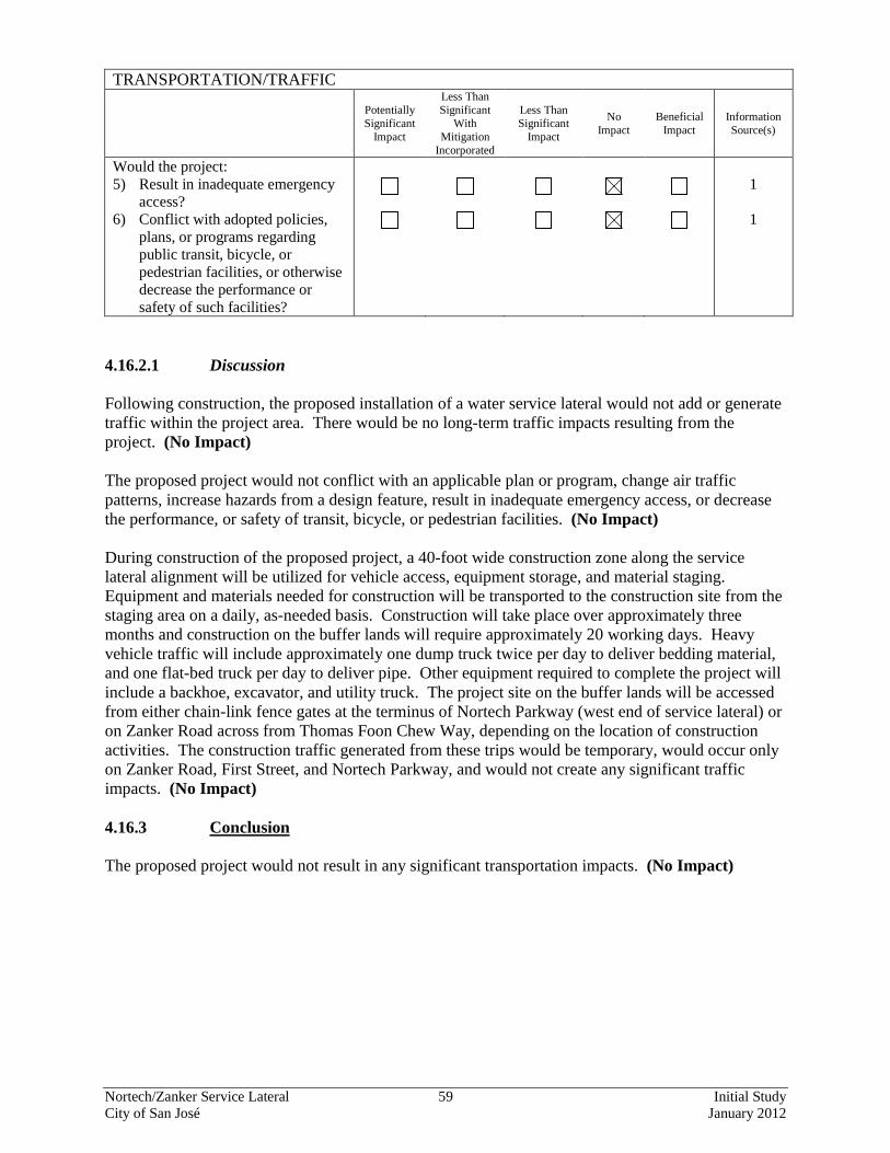
Nortech/Zanker Service Lateral 59 Initial Study City of San José January 2012
TRANSPORTATION/TRAFFIC
Potentially Significant
Impact
Less Than Significant
With Mitigation
Incorporated
Less Than Significant
Impact
No Impact
Beneficial Impact
Information Source(s)
Would the project: 5) Result in inadequate emergency
access?
1
6) Conflict with adopted policies, plans, or programs regarding public transit, bicycle, or pedestrian facilities, or otherwise decrease the performance or safety of such facilities?
1
4.16.2.1 Discussion Following construction, the proposed installation of a water service lateral would not add or generate traffic within the project area. There would be no long-term traffic impacts resulting from the project. (No Impact) The proposed project would not conflict with an applicable plan or program, change air traffic patterns, increase hazards from a design feature, result in inadequate emergency access, or decrease the performance, or safety of transit, bicycle, or pedestrian facilities. (No Impact) During construction of the proposed project, a 40-foot wide construction zone along the service lateral alignment will be utilized for vehicle access, equipment storage, and material staging. Equipment and materials needed for construction will be transported to the construction site from the staging area on a daily, as-needed basis. Construction will take place over approximately three months and construction on the buffer lands will require approximately 20 working days. Heavy vehicle traffic will include approximately one dump truck twice per day to deliver bedding material, and one flat-bed truck per day to deliver pipe. Other equipment required to complete the project will include a backhoe, excavator, and utility truck. The project site on the buffer lands will be accessed from either chain-link fence gates at the terminus of Nortech Parkway (west end of service lateral) or on Zanker Road across from Thomas Foon Chew Way, depending on the location of construction activities. The construction traffic generated from these trips would be temporary, would occur only on Zanker Road, First Street, and Nortech Parkway, and would not create any significant traffic impacts. (No Impact) 4.16.3 Conclusion The proposed project would not result in any significant transportation impacts. (No Impact)
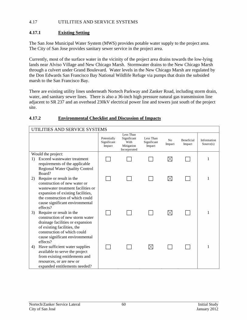
Nortech/Zanker Service Lateral 60 Initial Study City of San José January 2012
4.17 UTILITIES AND SERVICE SYSTEMS 4.17.1 Existing Setting The San Jose Municipal Water System (MWS) provides potable water supply to the project area. The City of San Jose provides sanitary sewer service in the project area. Currently, most of the surface water in the vicinity of the project area drains towards the low-lying lands near Alviso Village and New Chicago Marsh. Stormwater drains to the New Chicago Marsh through a culvert under Grand Boulevard. Water levels in the New Chicago Marsh are regulated by the Don Edwards San Francisco Bay National Wildlife Refuge via pumps that drain the subsided marsh to the San Francisco Bay. There are existing utility lines underneath Nortech Parkway and Zanker Road, including storm drain, water, and sanitary sewer lines. There is also a 36-inch high pressure natural gas transmission line adjacent to SR 237 and an overhead 230kV electrical power line and towers just south of the project site. 4.17.2 Environmental Checklist and Discussion of Impacts UTILITIES AND SERVICE SYSTEMS
Potentially Significant
Impact
Less Than Significant
With Mitigation
Incorporated
Less Than Significant
Impact
No Impact
Beneficial Impact
Information Source(s)
Would the project: 1) Exceed wastewater treatment
requirements of the applicable Regional Water Quality Control Board?
1
2) Require or result in the construction of new water or wastewater treatment facilities or expansion of existing facilities, the construction of which could cause significant environmental effects?
1
3) Require or result in the construction of new storm water drainage facilities or expansion of existing facilities, the construction of which could cause significant environmental effects?
1
4) Have sufficient water supplies available to serve the project from existing entitlements and resources, or are new or expanded entitlements needed?
1
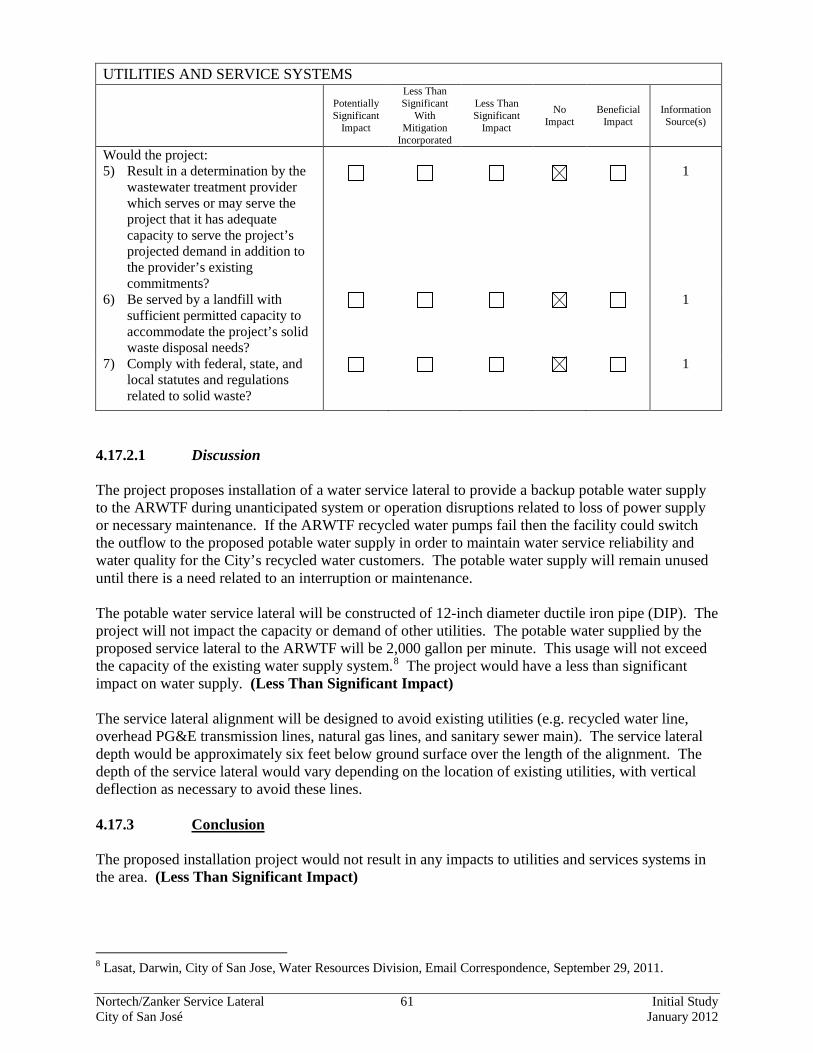
Nortech/Zanker Service Lateral 61 Initial Study City of San José January 2012
UTILITIES AND SERVICE SYSTEMS
Potentially Significant
Impact
Less Than Significant
With Mitigation
Incorporated
Less Than Significant
Impact
No Impact
Beneficial Impact
Information Source(s)
Would the project: 5) Result in a determination by the
wastewater treatment provider which serves or may serve the project that it has adequate capacity to serve the project’s projected demand in addition to the provider’s existing commitments?
1
6) Be served by a landfill with sufficient permitted capacity to accommodate the project’s solid waste disposal needs?
1
7) Comply with federal, state, and local statutes and regulations related to solid waste?
1
4.17.2.1 Discussion The project proposes installation of a water service lateral to provide a backup potable water supply to the ARWTF during unanticipated system or operation disruptions related to loss of power supply or necessary maintenance. If the ARWTF recycled water pumps fail then the facility could switch the outflow to the proposed potable water supply in order to maintain water service reliability and water quality for the City’s recycled water customers. The potable water supply will remain unused until there is a need related to an interruption or maintenance. The potable water service lateral will be constructed of 12-inch diameter ductile iron pipe (DIP). The project will not impact the capacity or demand of other utilities. The potable water supplied by the proposed service lateral to the ARWTF will be 2,000 gallon per minute. This usage will not exceed the capacity of the existing water supply system.8
The project would have a less than significant impact on water supply. (Less Than Significant Impact)
The service lateral alignment will be designed to avoid existing utilities (e.g. recycled water line, overhead PG&E transmission lines, natural gas lines, and sanitary sewer main). The service lateral depth would be approximately six feet below ground surface over the length of the alignment. The depth of the service lateral would vary depending on the location of existing utilities, with vertical deflection as necessary to avoid these lines. 4.17.3 Conclusion The proposed installation project would not result in any impacts to utilities and services systems in the area. (Less Than Significant Impact)
8 Lasat, Darwin, City of San Jose, Water Resources Division, Email Correspondence, September 29, 2011.
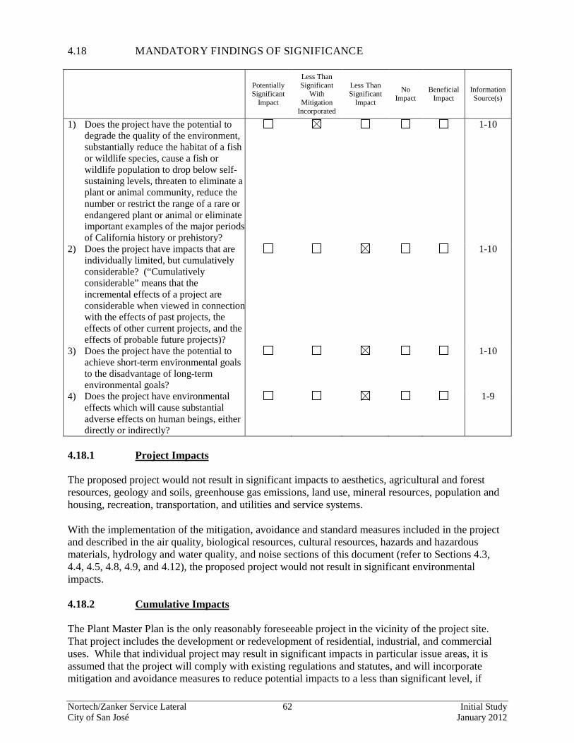
Nortech/Zanker Service Lateral 62 Initial Study City of San José January 2012
4.18 MANDATORY FINDINGS OF SIGNIFICANCE
Potentially Significant
Impact
Less Than Significant
With Mitigation
Incorporated
Less Than Significant
Impact
No Impact
Beneficial Impact
Information Source(s)
1) Does the project have the potential to degrade the quality of the environment, substantially reduce the habitat of a fish or wildlife species, cause a fish or wildlife population to drop below self-sustaining levels, threaten to eliminate a plant or animal community, reduce the number or restrict the range of a rare or endangered plant or animal or eliminate important examples of the major periods of California history or prehistory?
1-10
2) Does the project have impacts that are individually limited, but cumulatively considerable? (“Cumulatively considerable” means that the incremental effects of a project are considerable when viewed in connection with the effects of past projects, the effects of other current projects, and the effects of probable future projects)?
1-10
3) Does the project have the potential to achieve short-term environmental goals to the disadvantage of long-term environmental goals?
1-10
4) Does the project have environmental effects which will cause substantial adverse effects on human beings, either directly or indirectly?
1-9
4.18.1 Project Impacts The proposed project would not result in significant impacts to aesthetics, agricultural and forest resources, geology and soils, greenhouse gas emissions, land use, mineral resources, population and housing, recreation, transportation, and utilities and service systems. With the implementation of the mitigation, avoidance and standard measures included in the project and described in the air quality, biological resources, cultural resources, hazards and hazardous materials, hydrology and water quality, and noise sections of this document (refer to Sections 4.3, 4.4, 4.5, 4.8, 4.9, and 4.12), the proposed project would not result in significant environmental impacts. 4.18.2 Cumulative Impacts The Plant Master Plan is the only reasonably foreseeable project in the vicinity of the project site. That project includes the development or redevelopment of residential, industrial, and commercial uses. While that individual project may result in significant impacts in particular issue areas, it is assumed that the project will comply with existing regulations and statutes, and will incorporate mitigation and avoidance measures to reduce potential impacts to a less than significant level, if
Nortech/Zanker Service Lateral 63 Initial Study City of San José January 2012
necessary. For example, all projects are required to incorporate construction best management practices and comply with local and regional regulations to reduce impacts to air and water quality to the maximum extent feasible. In addition, the proposed project once installed will have no ongoing development impacts because all impacts are temporary and occur only during construction. 4.18.2.1 Construction Impacts With mitigation and avoidance measures, the proposed project would result in less than significant impacts from the effects of project construction on air quality, noise, transportation, and water quality. The construction of the anticipated or pending projects in the area would result in short-term impacts at various locations throughout the area. The cumulative project’s construction schedules will vary and construction is likely to occur over several years. In addition, the project would generally be required to implement standard measures and controls to further reduce construction impacts to nearby sensitive receptors. Given these factors, the construction impacts associated with a pending project would not result in a significant cumulative impact. 4.18.2.2 Air Quality and Greenhouse Gas Emission Impacts Past, present and future development projects contribute to the region’s adverse air quality impacts on a cumulative basis. By its very nature, air pollution is largely a cumulative impact. No single project is sufficient in size to, by itself, result in nonattainment of ambient air quality standards. Instead, a project’s individual emissions contribute to existing cumulatively significant adverse air quality impacts. If a project’s contribution to the cumulative impact is considerable, then the project’s impact on air quality would be considered significant. As described in Section 4.3, the project would not result in any daily emissions of criteria pollutants from operation of the project and is therefore, below the significance thresholds established by the BAAQMD. The project would not result in a cumulative air quality impact. Similar to regulated air pollutants, GHG emissions and global climate change also represent cumulative impacts. The project’s contribution to global climate change is discussed in Section 4.7 in terms of the project’s greenhouse gas emissions. The project would not conflict with plans, policies or regulation adopted for the purpose of reducing the emissions of greenhouse gases. 4.18.3 Short-term Environmental Goals vs. Long-term Environmental Goals The proposed project would not commit resources in a wasteful or inefficient manner. The purpose of the project is provide a backup water supply to maintain reliability of recycled water. The project would not induce substantial job or population growth or result in a large or irretrievable commitment of resources. 4.18.4 Direct or Indirect Adverse Effects As noted previously, the project could result in hazardous materials and air quality impacts during construction that could have health effects on people. With the implementation of the mitigation and standard measures included in the project and described in the specific sections of this report (refer to Section 4.0 Environmental Setting, Checklist, and Discussion of Impacts) of this Initial Study, the proposed project would not result in substantial adverse effects on human beings.
Nortech/Zanker Service Lateral 64 Initial Study City of San José January 2012
4.18.5 Conclusion The proposed project would not degrade the quality of the environment, reduce habitat for plant or animal species, or eliminate examples of periods of California history. The proposed project would not make a cumulatively considerable contribution towards a significant cumulative impact, achieve short-term goals to the disadvantage of long-term goals or cause adverse effects on human beings. As indicated in Section 4.0, the impacts of the proposed project would only occur during construction activities; no impacts are expected following completion of the project construction. Given that construction of the proposed project would not overlap with development of the buffer lands under the Plant Master Plan, no cumulative impacts would be expected to result from implementation of the project. (Less Than Significant Impact with Mitigation)
Nortech/Zanker Service Lateral 65 Initial Study City of San José January 2012
Checklist Sources:
1. Judgment of the professional planner completing the checklist, based on visual reconnaissance of the site, review of relevant background information, and professional judgment.
2. Project description and information and plans.
3. San Jose 2020 General Plan
4. City of San Jose, Municipal Code.
5. California Department of Conservation, 2008 Important Farmlands Map, July 2009.
6. Bay Area Air Quality Management District, CEQA Air Quality Guidelines. Updated May 2011.
7. H.T. Harvey & Associates, Nortech –Zanker Service Lateral Biological Resources Report, September 2011.
8. Basin Research Associates, Archaeological Assessment Report Nortech/Zanker Main Connection Project, August 2011.
9. USDA Soil Conservation Service, Soils of Santa Clara County. 1968; Association of Bay Area Governments (ABAG). Dam Failure Inundation Maps; Tsunami Inundation Emergency Planning Map for the San Francisco Bay Region; California Geological Survey 2001-04 (2001), Official Map of Alquist-Priolo Earthquake Fault Zones; Santa Clara County. Geologic Hazards Zones Maps 03 and 11, February 26, 2002; Santa Clara County. Liquefaction Zones Maps 03 and 11, June 21, 2002, September 23, 2002.
10. McCloskey Consultants, Soil Testing Laboratory Results, September 2011; California Department of Forestry and Fire Protection (CDFFP) 2009. California Fire Hazard Severity Zone Map Update Project; California Department of Toxic Substances Control. Envirostor. October 2010.
Nortech/Zanker Service Lateral 66 Initial Study City of San José January 2012
SECTION 5.0 REFERENCES Association of Bay Area Governments. Building Momentum: Projections and Priorities 2009, August 2009. Available at: <http://abag.org/planning/currentfcst/> Association of Bay Area Governments (ABAG). Dam Failure Inundation Maps. Available at: <http://quake.abag.ca.gov/dam-failure/> Association of Bay Area Governments. Tsunami Inundation Emergency Planning Map for the San Francisco Bay Region. Available at: <http://www.abag.ca.gov/bayarea/eqmaps/tsunami/tsunami.html> Basin Research Associates, Archaeological Assessment Report Nortech/Zanker Main Connection Project, August 2011. Bay Area Air Quality Management District. CEQA Air Quality Guidelines. Updated May 2011. California Climate Change Center. Impacts of Sea-Level Rise on the California Coast. March 2009. California Department of Conservation. Santa Clara County Important Farmlands Map 2008. Map. July 2009. California Department of Forestry and Fire Protection (CDFFP) 2009. California Fire Hazard Severity Zone Map Update Project. February 2009. http://www.fire.ca.gov/fire_prevention/fire_prevention_wildland_zones_maps.php California Department of Toxic Substances Control. Envirostor. October 2010. http://www.envirostor.dtsc.ca.gov/public California Geological Survey 2001-04 (2001), Official Map of Alquist-Priolo Earthquake Fault Zones. Available at: http://quake.abag.ca.gov/faults/ City of San Jose, (Revisions), San Jose 2020 General Plan. City of San Jose, Zoning Ordinance. Federal Emergency Management Agency. Flood Insurance Rate Map, Santa Clara County, California, Map Number 06085C0062H. Effective Date: May 18, 2009. H.T. Harvey & Associates, Nortech –Zanker Service Lateral Biological Resources Report, November 2011. McCloskey Consultants, Nortech Service Lateral Phase II Soil Testing Results, September 2010 Santa Clara County. Geologic Hazards Zones Maps 03 and 11, February 26, 2002. Available at: http://www.sccgov.org/SCC/docs/Planning,%20Office%20of%20(DEP)/attachments/58248011.pdf http://www.sccgov.org/SCC/docs/Planning,%20Office%20of%20(DEP)/attachments/58257203.pdf Santa Clara County. Liquefaction Hazards Zones Maps 03 and 11, June 21, 2002, September 23, 2002. Available at:
Nortech/Zanker Service Lateral 67 Initial Study City of San José January 2012
http://www.sccgov.org/SCC/docs/Planning,%20Office%20of%20(DEP)/attachments/58265703.pdf http://www.sccgov.org/SCC/docs/Planning,%20Office%20of%20(DEP)/attachments/58259611.pdf Santa Clara Valley Habitat Plan. (Santa Clara Valley Habitat Conservation Plan/Natural Community Conservation Plan (HCP/NCCP). Available at: <http://www.scv-habitatplan.org/www/default.aspx> Santa Clara Valley Water District/U.S. Department of the Interior, Bureau of Reclamation. South Bay Advanced Recycled Water Treatment Facility, Final Environmental Assessment/Initial Study-Mitigated Negative Declaration. February 2010. USDA Soil Conservation Service, Soils of Santa Clara County. 1968. US Environmental Protection Agency, Region 9: Superfund Site Overview – South Bay Asbestos Area, December 2009. Available at: http://yosemite.epa.gov/r9/sfund/r9sfdocw.nsf/3dec8ba3252368428825742600743733/b4b49ead45bdf56c88257007005e93f0!OpenDocument Sowers & Thompson, Oakland Museum of California. Creek & Watershed Map of Milpitas and North San Jose. 2005.
Nortech/Zanker Service Lateral 68 Initial Study City of San José January 2012
SECTION 6.0 LEAD AGENCY AND CONSULTANTS LEAD AGENCY
City of San Jose Department of Planning, Building, and Code Enforcement Joe Horwedel, Director Janis Moore, Planner II
CONSULTANTS David J. Powers & Associates, Inc. Environmental Consultants and Planners Judy Shanley, Principal Julie Wright, Senior Project Manager Stephanie Francis, Graphic Artist
Basin Research Associates Cultural Resources Consultants Colin Busby, President H.T. Harvey and Associates, Inc Biological Consultants Steve Rottenborn, Principal/Senior Wildlife Ecologist Patrick Boursier, Senior Plant/Wetlands Ecologist Julie Klingmann, Project Manager/Senior Wildlife Ecologist Brian Cleary, Botanist Nellie Thorngate, Wildlife Ecologist McCloskey Consultants Environmental and Geotechnical Consultants Tom McCloskey, P.G. C.E.G. C.Hg.

Appendix A
Biological Resources Report
Appendix B
Phase II Environmental Soil Sampling