Embed Size (px)
Citation preview
Samuel H. Boardman State Scenic Corridor
For more information:Harris Beach Management Unit
1655 Highway 101 N.Brookings, OR 97415
541-469-0224State Park Information Line: 800-551-6949
Printed on Recycled Paper
All information or fees subject to change without notice. This brochure is available in alternative formats upon request.
Call 1-800-551-6949. Oregon Relay for the hearing impaired: dial 711.63400-9838 (03/15)
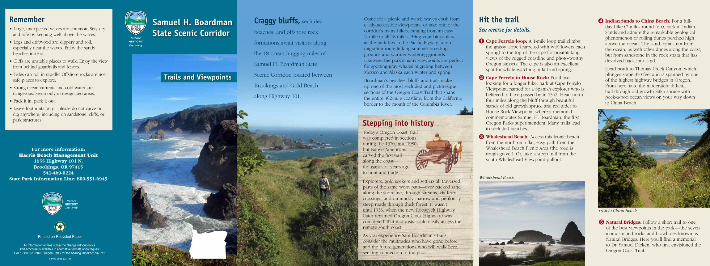
Craggy bluffs, secluded
beaches, and offshore rock
formations await visitors along
the 18 ocean-hugging miles of
Samuel H. Boardman State
Scenic Corridor, located between
Brookings and Gold Beach
along Highway 101.
Come for a picnic and watch waves crash from easily-accessible viewpoints, or take one of the corridor’s many hikes, ranging from an easy ¼ mile to all 18 miles. Bring your binoculars, as the park lies in the Pacific Flyway, a bird migration route linking summer breeding grounds and warmer wintering grounds. Likewise, the park’s many viewpoints are perfect for spotting gray whales migrating between Mexico and Alaska each winter and spring.
Boardman’s beaches, bluffs and trails make up one of the most secluded and picturesque sections of the Oregon Coast Trail that spans the entire 362-mile coastline, from the California border to the mouth of the Columbia River.
Stepping into historyToday’s Oregon Coast Trail was completed in sections during the 1970s and 1980s, but Native Americans carved the first trail along the coast thousands of years ago to hunt and trade.
Explorers, gold seekers and settlers all traversed parts of the same worn path—over packed sand along the shoreline, through streams, via ferry crossings, and on muddy, narrow and perilously steep roads through thick forest. It wasn’t until 1936, when the new Roosevelt Highway (later renamed Oregon Coast Highway) was completed, that motorists could easily access the remote south coast.
As you experience Sam Boardman’s trails, consider the multitudes who have gone before and the future generations who will walk here, seeking connection to the past.
Hit the trailSee reverse for details.
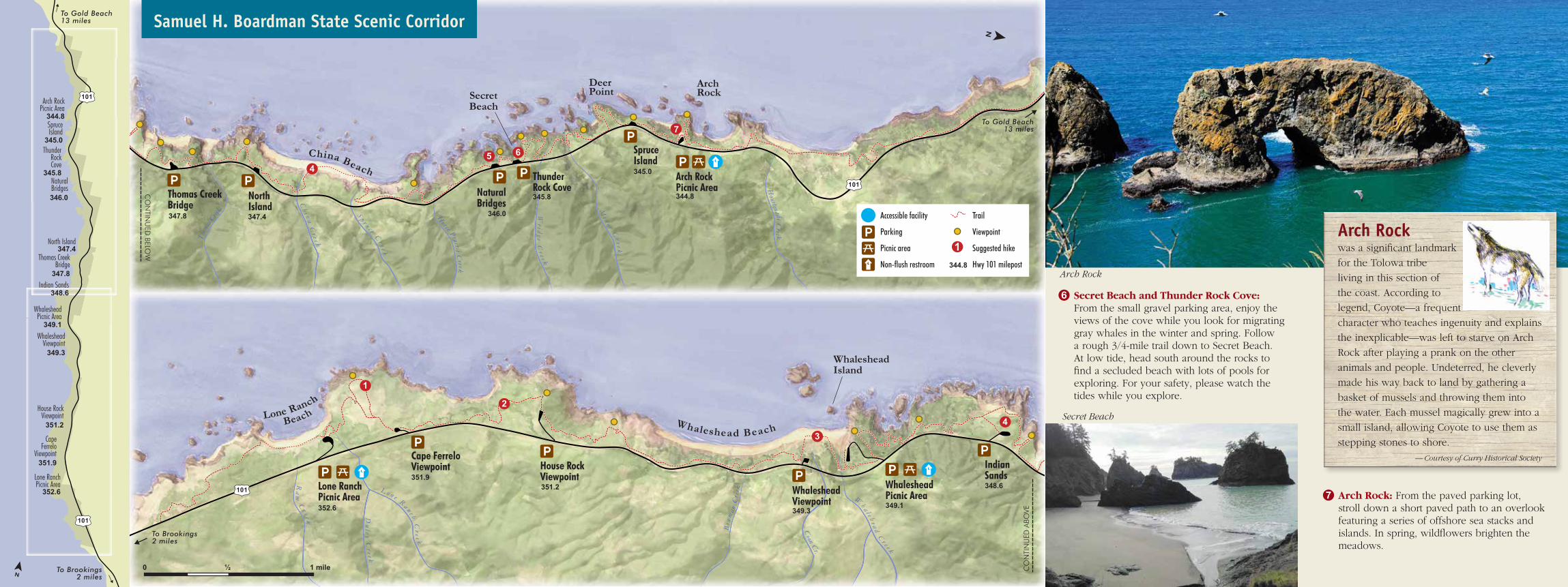
1 Cape Ferrelo loop: A 1-mile loop trail climbs the grassy slope (carpeted with wildflowers each spring) to the top of the cape for breathtaking views of the rugged coastline and photo-worthy Oregon sunsets. The cape is also an excellent spot for whale watching in fall and spring.
2 Cape Ferrelo to House Rock: For those looking for a longer hike, park at Cape Ferrelo Viewpoint, named for a Spanish explorer who is believed to have passed by in 1542. Head north four miles along the bluff through beautiful stands of old growth spruce and red alder to House Rock Viewpoint, where a memorial commemorates Samuel H. Boardman, the first Oregon Parks superintendent. Many trails lead to secluded beaches.
3 Whaleshead Beach: Access this iconic beach from the north on a flat, easy path from the Whaleshead Beach Picnic Area (the road is rough gravel). Or, take a steep trail from the south Whaleshead Viewpoint pullout.
4 Indian Sands to China Beach: For a full-day hike (7 miles round-trip), park at Indian Sands and admire the remarkable geological phenomenon of rolling dunes perched high above the ocean. The sand comes not from the ocean, as with other dunes along the coast, but from sandstone in the rock strata that has devolved back into sand.
Head north to Thomas Creek Canyon, which plunges some 350 feet and is spanned by one of the highest highway bridges in Oregon. From here, take the moderately difficult trail through old growth Sitka spruce with peek-a-boo ocean views on your way down to China Beach.
5 Natural Bridges: Follow a short trail to one of the best viewpoints in the park—the seven iconic arched rocks and blowholes known as Natural Bridges. Here you’ll find a memorial to Dr. Samuel Dicken, who first envisioned the Oregon Coast Trail.
Whaleshead Beach
Trail to China Beach
Remember• Large, unexpected waves are common. Stay dry
and safe by keeping well above the waves.
• Logs and driftwood are slippery and roll, especially near the waves. Enjoy the sandy beaches instead.
• Cliffs are unstable places to walk. Enjoy the view from behind guardrails and fences.
• Tides can roll in rapidly! Offshore rocks are not safe places to explore.
• Strong ocean currents and cold water are dangerous. Swim only in designated areas.
• Pack it in; pack it out.
• Leave footprints only—please do not carve or dig anywhere, including on sandstone, cliffs, or park structures.
Trails and Viewpoints
101
101
To Brookings2 miles
Indian Sands
SpruceIsland
345.0
Arch RockPicnic Area
344.8
ThunderRockCove
345.8NaturalBridges346.0
North Island347.4
Thomas CreekBridge
347.8
348.6
WhalesheadPicnic Area
349.1
House RockViewpoint
351.2
CapeFerrelo
Viewpoint351.9
Lone RanchPicnic Area
352.6
WhalesheadViewpoint
349.3
To Gold Beach13 miles
To Gold Beach13 miles
Houstenade C
reek
S p r u c e Cr e e k
Ch i n a C
r e e k
Horse Prairie C
r e ek
Wridge C
r e e k
Thom
as Cree
k Mi n e r C
r e ek
45 6
7
ArchRock
DeerPointSecret
Beach
ThunderRock CoveNatural
BridgesThomas CreekBridge
China Beach Arch RockPicnic Area
NorthIsland
SpruceIsland345.0
344.8101
345.8
346.0347.4347.8
344.8
Accessible facility
Parking
Picnic area
Non-flush restroom
Trail
Viewpoint
Suggested hike
Hwy 101 milepost
1
To Brookings2 miles
Bow
man
Cr e
ekL o n e R a n c h Cre e k
Dule y C
r e e k
Ra
m C
r e e k
W
h a l e h e a d Cr e e k
Coon Cr.
1
2
34
Lone RanchPicnic Area
Cape FerreloViewpoint House Rock
Viewpoint
WhalesheadIsland
IndianSands
Whaleshead BeachLone Ranch
Beach
WhalesheadPicnic AreaWhaleshead
Viewpoint
348.6
349.1
351.2351.9
352.6 349.3
101
0 ½ 1 mile
CO
NTIN
UED
BELOW
CO
NTI
NU
ED A
BOVE
Samuel H. Boardman State Scenic Corridor
6 Secret Beach and Thunder Rock Cove: From the small gravel parking area, enjoy the views of the cove while you look for migrating gray whales in the winter and spring. Follow a rough 3/4-mile trail down to Secret Beach. At low tide, head south around the rocks to find a secluded beach with lots of pools for exploring. For your safety, please watch the tides while you explore.
7 Arch Rock: From the paved parking lot, stroll down a short paved path to an overlook featuring a series of offshore sea stacks and islands. In spring, wildflowers brighten the meadows.
Secret Beach
Arch Rock was a significant landmark
for the Tolowa tribe
living in this section of
the coast. According to
legend, Coyote—a frequent
character who teaches ingenuity and explains
the inexplicable—was left to starve on Arch
Rock after playing a prank on the other
animals and people. Undeterred, he cleverly
made his way back to land by gathering a
basket of mussels and throwing them into
the water. Each mussel magically grew into a
small island, allowing Coyote to use them as
stepping stones to shore.
—Courtesy of Curry Historical Society
Arch Rock
101
101
To Brookings2 miles
Indian Sands
SpruceIsland
345.0
Arch RockPicnic Area
344.8
ThunderRockCove
345.8NaturalBridges346.0
North Island347.4
Thomas CreekBridge
347.8
348.6
WhalesheadPicnic Area
349.1
House RockViewpoint
351.2
CapeFerrelo
Viewpoint351.9
Lone RanchPicnic Area
352.6
WhalesheadViewpoint
349.3
To Gold Beach13 miles
To Gold Beach13 miles
Houstenade C
reek
S p r u c e Cr e e k
Ch i n a C
r e e k
Horse Prairie C
r e ek
Wridge C
r e e k
Thom
as Cree
k Mi n e r C
r e ek
45 6
7
ArchRock
DeerPointSecret
Beach
ThunderRock CoveNatural
BridgesThomas CreekBridge
China Beach Arch RockPicnic Area
NorthIsland
SpruceIsland345.0
344.8101
345.8
346.0347.4347.8
344.8
Accessible facility
Parking
Picnic area
Non-flush restroom
Trail
Viewpoint
Suggested hike
Hwy 101 milepost
1
To Brookings2 miles
Bow
man
Cr e
ekL o n e R a n c h Cre e k
Dule y C
r e e k
Ra
m C
r e e k
W
h a l e h e a d Cr e e k
Coon Cr.
1
2
34
Lone RanchPicnic Area
Cape FerreloViewpoint House Rock
Viewpoint
WhalesheadIsland
IndianSands
Whaleshead BeachLone Ranch
Beach
WhalesheadPicnic AreaWhaleshead
Viewpoint
348.6
349.1
351.2351.9
352.6 349.3
101
0 ½ 1 mile
CO
NTIN
UED
BELOW
CO
NTI
NU
ED A
BOVE
Samuel H. Boardman State Scenic CorridorSamuel H. Boardman State Scenic Corridor