Embed Size (px)
Citation preview

!
!
!
!
!!
!
!
!
!
!
!!
!
!
!
!
!!
!!
!
!
!
!!
!
!
!
!
!
!!
!
!!
!
!
!
!!
!
!
!
!
!
!
!!
!!
!
!!
!
!!
!
!
!!
!
!!!!!
!
!
!
!
!
!
!
!
! !
!
!
!
!
!!
!!
!
!
!
!
!
!
!!
!!
!!
!!
!!
!
!
!!
!
!
!!
!
!
!
!
!
! !
!
!
!
!
!
!
!
!
!
!
!
!
!!
!
!
!
!
!!
!!
!!
!
!
!
!
!
!
!
!
!
!
!
!!
!!
!
")
")")
")")
")
")
")
")
")
")")
")")
")
")1
6
8
35
2
9
4
11
1213
1415
16
10
7
/Paradise Coast BluewaySaltwater Paddling Trails
Collier County
0 5 102.5Miles
Boat Ramps and Beach AccessSegment Waypoint Location Latitude, Longitude
1
1 Gulf Coast Ranger Station 25.845752, -81.3870342 Port of Islands Boat Ramp 25.956767, -81.5116563 Goodland Boat Park 25.920917, -81.6460144 Caxambas Park Boat Ramp 25.912595, -81.7170795 South Marco Island Beach Access 25.912220, -81.7256456 Tigertail Beach Park 25.948933, -81.743036
27 Collier Blvd - 951 Boat Ramp 25.980431, -81.7033288 Isles of Capri Paddlecraft Park 25.985260, -81.7042479 Bayview Park Boat Ramp 26.102725, -81.784308
3
10 North Gulfshore Beach Access 26.207262, -81.81467111 Clam Pass Beach Park 26.211011, -81.81256212 Vanderbilt Beach Access 26.253437, -81.82114313 Bluebill Beach Access 26.272278, -81.82660614 Cocohatchee River Park Boat Ramp 26.293582, -81.82006715 Barefoot Beach Preserve Park 26.300850, -81.83308016 Barefoot Beach Access 26.330324, -81.844990

!
!
!
!
!!
!
!
!
!!!
!
!
!
!
!
!
!!
!
!!
!
!
!!
!
!
!
!
!
!
!!
!
!!
!
!
!
!
!
!
!
!
!!
!
!
!!
!!
!
!
!
!
!
!
!!
!
!
!
!
!
!!!!
!
!
!
!
!
!
!
!
!
!
!
!
!
!
!
!
!!
!
!!
!
!!
!
!
!
!!
!!
!!
!!
!!
!
!
!!
!
!
!
!
!
!
!
!
!
!
!
!
!
!
!
!
!
!
!
!
!
!
!
!!
!
!
!
!
!
!
!
!!!
!
!
!
!
!
!
!
!!
!
!
!
!
!
!!
!!
")
")")")")
")
")
")
")
")
")")
")")
")
")1
6
8
35
2
9
11
12
13
15
16
Paradise Coast BluewaySaltwater Paddling Trails
Collier CountyBoat Ramp & Park Amenities
Everglades City - Cocohatchee Boat Ramp
/
0 5 102.5Miles
^̂̂̂̂̂̂̂^̂̂̂̂̂̂̂̂̂̂̂
4
14
10
7
ID Name Address Amenities
1 30 3 5
2 22 2 71
3 13 3 73 2
4 84 4 54 1
7 10 72 2
8 51 6 5
9 Bayview Boat Park 12 2 55 2
14 14 4 54 2
Car Parking
Handicapped Car Parking
Boat Trailer
ParkingHandicapped Boat Trailer
Parking
Gulf Coast Ranger Station
815 Oyster Bar Lane Everglades City, FL
34139Marina, Boat/Kayak Tours, Picnic Area, Receptacles,
Restrooms
Port of the Islands Marina
525 Newport Drive Naples, FL 34114
Ship Store, Fuel, Fish Cleaning Table, Picnic Area,
Restrooms
Goodland Boat Park
750 Palm PointMarco Island, FL 34145
Ship Store, Fishing Pier,Fish Cleaning Table, Picnic
Area, Restrooms
Caxambas Park Boat Ramp
909 Collier CourtMarco Island, FL 34145
Ship Store, Fuel, Fishing Pier, Fish Cleaning Table,
Picnic Area,Restrooms, Pump-out
Station
Collier Boat Rampaka 951 Boat Ramp
3620 Collier Blvd Naples, FL 34114
Fish Cleaning Table, Port-o-let
Isles of Capri Paddlecraft Park
1295 Capri BlvdNaples, FL 34114
Picnic Area, Restrooms, Non-Motorized Launch
1500 Danford Street Naples, FL 34112
Fishing Pier, Fish Cleaning Table, Picnic Area,
Restrooms, Playground
Cocohatchee River Park Boat Ramp
13531 Vanderbilt Drive Naples, FL 34110
Ship Store, Fuel, Fish Cleaning Table, Picnic Area,
Restrooms, Pump-out Station, Playground

!
!
!
!
!!
!
!
!
!!!
!
!
!
!
!
!
!!
!
!!
!
!
!!
!
!
!
!
!
!
!!
!
!!
!
!
!
!
!
!
!
!
!!
!
!
!!
!!
!
!
!
!
!
!
!!
!
!
!
!
!
!!!!
!
!
!
!
!
!
!
!
!
!
!
!
!
!
!
!
!!
!
!!
!
!!
!
!
!
!!
!!
!!
!!
!!
!
!
!!
!
!
!
!
!
!
!
!
!
!
!
!
!
!
!
!
!
!
!
!
!
!
!
!!
!
!
!
!
!
!
!
!!!
!
!
!
!
!
!
!
!!
!
!
!
!
!
!!
!!
")
")")")")
")
")
")
")
")
")")
")")
")
")1
6
8
35
2
9
11
12
13
15
16
Paradise Coast BluewaySaltwater Paddling Trails
Collier CountyBeach Access Amenities
Marco Island South - Barefoot Beach
/
0 5 102.5Miles
^̂̂̂̂̂̂̂^̂̂̂̂̂̂̂̂̂̂̂
4
14
10
7
ID Name Address Parking Amenities
5 64 3
6 226 6
10 36 2
11 191 7
12 343 12
13 N/A N/A
15 229 13
16 90 6
Handicap Parking
Marco Island South Beach
Access930 South Collier Blvd Marco Island, FL 34145
Restrooms, Solar Parking Meter, Foot Showers, Trash Receptacles
Tigertail Beach Park
480 Hernando Drive Marco Island, FL 34145
Restrooms, Children's Playground, Restaurant, BBQ Grills, Picnic Area, Beach
Rentals, Booth Attendant, Solar Parking Meter, Park Rangers, Trash Receptacles,
Boardwalks, Dune Crossovers
North Gulf Shore Beach Access
North Gulf Shore Blvd Naples, FL 34102
Solar Parking Meter, Bike Rack, Showers,
Trash Receptacles
Clam Pass Beach Park
465 Seagate Drive Naples, FL 34103
Solar Parking Meter, Booth Attendant,Tram Ride to Beach, Bike Rack,
Beach Concession, Trash Receptacles, Restrooms
Vanderbilt Beach Park
100 Vanderbilt Beach Rd Naples, FL 34108
Booth Attendant, Parking Garage,Restrooms, Foot Showers,
Beach Concession, Trash Receptacles,Solar Parking Meter, Bike Racks
Bluebill Beach Access
11129 Park Drive Naples, FL 34108
No Parking/Drop Off Only, Restrooms,Foot Showers, Bike Rack
Barefoot Beach Preserve Park
505 Barefoot Beach Blvd Bonita Springs, FL
34134
Booth Attendant, Picnic Area,Beach Concession (Chairs, Cabanas),
Restrooms, Beach Wheelchair, Nature Trail, Environmental Learning Center, Butterfly Garden, Cactus Garden, Park Rangers,
Vending Machine,Trash Receptacles, Foot Showers, Boardwalk and Dune Crossovers,
Bike Rack
Barefoot Beach Access
5901 Bonita Beach Road Bonita Springs, FL 34134
Solar Parking Meter, Trash Receptacles,Picnic Pavilions, Restroom Facilities, Bike
Rack

!
!
!
!
!!
!
!
!
!
!
!
!!
!
!
!
!
!
!!
!
!!
!
!!!
!!!
!
!
!
!
!
!
!!
!
!
!
!
!!
!!
!
!
!
!
!!
!!
!
!
!!
!
!!
!
!
!
!
!
!
!
!
!
!
!
!!
!
!!
!
!
!!
!!
!
!
!!
!!
!!
!!
!!
!
!
!
!
!
!!
!
! !
!
!!
!
!
!
!
!
!
!
!!!! !
!
!
!
!
!
!
!
!
!
! !
!!
!
!
!
!
!!
! !
!
!
!
!
!
!!!
!
!
!
!
!
!!
!
!!
!
!!
!
!!
!!
!
!
!!!
!
!
!
!
!
!
!
!
!
!
")
")")")")
")
")
")
")")
")
")
")
")
")
")
")
")
")
")1
5
7
9
8
4
6
3 2
10
12
11
13
1415
161817
1920
Paradise Coast BluewaySaltwater Paddling Trails
Collier CountyGPS Trail Names
/
0 5 102.5Miles
Trail Name Miles1 Everglades City - Port of the Islands 20.02 Faka Union Bay Loop 4.03 Port of the Islands - Goodland 16.04 Caxambas Park - Helen Key Loop 8.55 Caxambas Bay Loop 4.36 Goodland Ramp - Bayview Boat Park 19.27 Marco Island South Beach - Tigertail Beach Park 8.08 951 Boat Ramp - Rookery Bay 9.39 Collier Blvd Bridge - Little Marco Island Loop 9.0
10 Isles of Capri Park - Johnson Bay Loop 7.011 Isles of Capri Park - Rookery Bay Reserve 11.012 Bayview Boat Park - Rookery Bay Reserve Loop 5.213 Bayview Ramp - Gordon Pass - Clam Pass Park 10.514 Clam Pass Beach Park - Outer Clam Bay - Beach Access 1.715 Clam Pass - Vanderbilt Beach 2.516 Vanderbilt Beach - Bluebill Beach 1.617 Bluebill Beach - Cocohatchee Park Boat Ramp 2.318 Delnor-Wiggins Pass State Park 1.019 Barefoot Beach Preserve Park - Wiggins Bay Loop 2.220 Cocohatchee Park Boat Ramp - Barefoot Beach 4.0
!
!
!
!
!!
!
!
!
!
!
!
!
!
!
!
!
!!
!!
!
!
!!
!
!
!
!
!
!!
!!
!
!!
!!
!
!
!
!
!
!
!!
!!
!
!!!
!
!!
!
!
!
!
!!
!!!
!
!
!
!
!
!
!
!
! !
!
!
!
!
!!
!!
!
!
!
!
!
!
!!
!!
!!
!!
!!
!
!!
!
!
!!
!
!
!
!
!
! !
!
!
!
!!
!
!
!
!
!
!
!
!!
!
!
!
!
!!
!!
!
!
!
!
!
!
!
!!
!
!!
!
!
!!
!
")
")")
")")
")
")
")
")
")
")")
")")
")
")
Segment 1
Segment 3
Segment 2
1
6
8
35
2
9
4
11
12131415
16
Paradise Coast BluewaySaltwater Paddling Trails
Collier CountyEverglades City - Barefoot Beach
/
0 5 102.5Miles
")")")")")")")")")
")")")")")") ")
LEE
COLLIER
10
7
Waypoint Location Latitude, Longitude1 Gulf Coast Ranger Station 25.845752, -81.3870342 Port of Islands Boat Ramp 25.956767, -81.5116563 Goodland Boat Park 25.920917, -81.6460144 Caxambas Park Boat Ramp 25.912595, -81.7170795 South Marco Island Beach Access 25.912220, -81.7256456 Tigertail Beach Park 25.948933, -81.7430367 Collier Blvd - 951 Boat Ramp 25.980431, -81.7033288 Isles of Capri Paddlecraft Park 25.985260, -81.7042479 Bayview Park Boat Ramp 26.102725, -81.784308
10 North Gulfshore Beach Access 26.207262, -81.81467111 Clam Pass Beach Park 26.211011, -81.81256212 Vanderbilt Beach Access 26.253437, -81.82114313 Bluebill Beach Access 26.272278, -81.82660614 Cocohatchee River Park Boat Ramp 26.293582, -81.82006715 Barefoot Beach Preserve Park 26.300850, -81.83308016 Barefoot Beach Access 26.330324, -81.844990

!
!
!
!!
!
!
!!
!
!!
!
!
!
!!
!
!!
!
!
!!!
!!
!
!!
!!
!
!!
!!
!
!
!
!
!!
!
!
!!
!
!
!
!
!!
!!
!
!
!
!!
!
!
!
!
!!
!
!!
!!
!!
!!
!
!
!
!
!
!!!
!!
!!
!
!!
!
!
!
!
!
!!
!
! !
!
!
!
!!
!!
!!
!!
!!
!!
!!
!!
!
!
!
!!
!
!
!!
!!
!
!!
!
!
!
!!
!
!
!
!
!!
!
!!
!
!!
!
!!!! !
!
!
!
!
!
!
!
!!
!
! !
!!
!!
!
!!
!
!
!
!
!!
!
!
!
!
!
!
!
!
!
!!!
!!!!
!!
!
!!
!
!
!
!!
!
!
!!
!!
!
!
!!
!
!
!!
!!
!!
!!
!
!
!
!
!!
!!
!
!!
!
!
!
!!
!
!!
!
!
")")
")
")
")
")
")")
")
")")
")
")
")
")
")
")
")")
")
")
")
")
")
")
")")
")
")")
")7
65
4
3 21
8
9
10
11
1413
12
15
17
18
27
26
23
2120
19
2425
28
22
16
0 5 102.5Miles
Paradise Coast BluewaySaltwater Paddling Trails
Collier CountyEverglades City
toBig Marco Pass
/Waypoint Name Latitude, Longitude
1 Everglades City 25.845785, -81.3870132 Lane Cove 25.859897, -81.4232183 West Pass Bay 25.860124, -81.4523604 Gaskin Bay 25.844896, -81.4843155 West Pass 25.828861, -81.5077546 Fakahatchee Pass 25.839455, -81.5346507 Panther Key 25.861178, -81.5374608 Port of the Islands 25.956767, -81.5116569 Faka Union Canal 25.921562, -81.509075
10 Faka Union Bay 25.899356, -81.51624811 Faka Union Bay Loop 25.882870, -81.52924112 Santina Bay 25.896442, -81.54683013 Fish Hawk Creek 25.890182, -81.57857314 Shell Key Bay 25.900870, -81.60396415 Snook Hole Channel - Blind Pass 25.880122, -81.67928316 Caxambas Pass 25.906849, -81.71591117 Coon Key Pass 25.910677, -81.63719518 Big Marco River 25.942719, -81.65439919 Collier Blvd Bridge 25.964753, -81.71085120 McIlvance Bay 25.987845, -81.70519421 Johnson Bay 25.994535, -81.73192922 Big Marco Pass 25.976038, -81.741456
Segment 1
!
!
!!!
!!
!
!!
!
!
!!
!!
!
!!
!
!
!
!!
!
!
!!
!
!
!
!!
!!
!
!
!
!
!!
!
!
!
!!
!
!
!
!!
!
!!
!!
!
!
!
!!
!!
!
!
!
!
!
!
!
!
!!!
!
!
!!
!
!!
!!
!
!
!
!
!
!
!!
!!
!!
!
!
!
!
!!
!
!
!
!
!
!
!
!
!!
!
!
!
!!
!
!!
!!
!
!
! !
!!
!
!
!!
!
!
!!
!!
!!
!!
!!
!!
!!
!!
!!
!!
!!
!!
!!
!!
!!
!
!
!
!!
!!!
!
!
!
!!
!!
!!
!
!
! !! !
!
!
!!
!!
!!
!!
!
!
!
!
!
!!!
!
!
!!
!
!
!
!!
!
!
!
!
!!
!
!!
!
!
!
!!
!
!
! !!
")
")
")
")
")
")
")")
")
")
")
")
")
")
")
")
")37
27
26
23
2425
28
293031
32
33
34
36
35
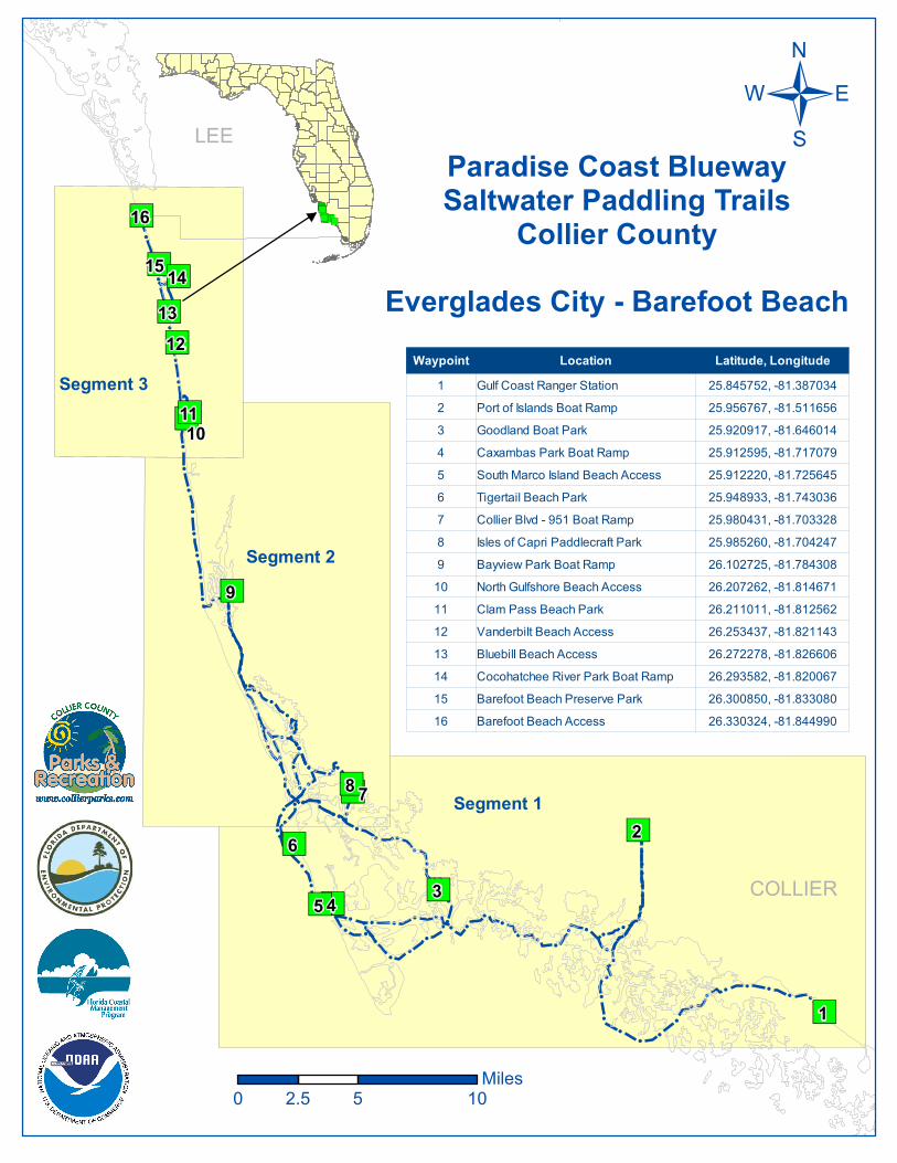
Paradise Coast BluewaySaltwater Paddling Trails
Collier CountyHurricane Pass
toClam Pass Park Kayak Launch
/
0 2 41Miles
Waypoint Name Latitude, Longitude23 Hurricane Pass 26.014198, -81.75772124 Rookery Bay Launch 26.026666, -81.73440725 Rookery Bay 26.034696, -81.75599626 Little Marco Pass 26.042579, -81.77498227 Shell Bay 26.060872, -81.77817228 Dollar Bay 26.083259, -81.78624429 Bayview Park Boat Ramp 26.100564, -81.78689130 Mangrove Islands 26.097704, -81.79473631 Gordon Pass 26.092737, -81.80370332 Port Royal 26.114476, -81.80559833 Municipal Pier 26.131442, -81.80915234 Hurricane Harbor 26.154389, -81.81074735 Doctors Pass 26.173914, -81.81619336 Venetian Bay 26.196729, -81.81768637 Clam Pass Park Kayak Launch 26.210990, -81.812620
Segment 2

!
!!
!!
!!
!!
!!
!!
!!
!!
!
!
!!
!
!!
!
!!!
!!
!
!!
!!
!!
!
!
!
!!
!
!!
!!
!!
!!
!!
!
! !!
!!
!!
!!
!!
!!
!!
!!
!!
!
!!
!
!!
!
!
!
!
!
!
!!
!
!!
!!
!!
!!
!!
!!
!!
!!
!!
!!
!!
!!
!!
!!
!!
!!
!!
!!
!!
!!
!!
!!
!!
!!
!!
!!
!!
!!
!
!
!!
!
!
!!
!!
!
!
!!
!
")
")
")
")
")")
")
")
")
")
")")
")
")
")
")
")
")
")")
")")49
50
5254
55
53
40
41
42
3938
45
44
43
46
4748
51
56
57
58 Paradise Coast BluewaySaltwater Paddling Trails
Collier CountyClam Pass Beach Access
to Barefoot Beach Access
/
0 1 20.5Miles
Waypoint Name Latitude, Longitude38 Clam Pass Beach Access 26.216763, -81.81770139 Clam Pass 26.219611, -81.81905140 Inner Clam Bay 26.227664, -81.82019641 Mangrove Islands 26.236872, -81.82130142 Vanderbilt Beach 26.245472, -81.82268943 Vanderbilt Beach Road 26.253784, -81.82373644 Vanderbilt Lagoon 26.260206, -81.82544245 Gulf Shore Drive 26.266118, -81.82705646 Bluebill Beach Access 26.272208, -81.82781147 Delnor-Wiggins Pass State Park Beach 26.281180, -81.83075648 Delnor-Wiggins Pass State Park Launch 26.277773, -81.82516749 Water Turkey Bay 26.279398, -81.82427650 Vanderbilt Channel 26.283042, -81.82586051 Cocohatchee River Park Boat Ramp 26.293582, -81.82006752 Mangrove Island Loop 26.293372, -81.82452753 Barefoot Beach Preserve Launch 26.300850, -81.83308054 Wiggins Bay 26.297195, -81.82708055 Delnor-Wiggins Pass 26.288805, -81.82715356 Wiggins Pass 26.288858, -81.83150557 Old Hickory Bay 26.310173, -81.83877258 Barefoot Beach Access 26.330324, -81.844990
Segment 3

")")
")
")
")
-3
-4-2
-1
-5
-6-7
-8
-6
-4
-4
-8
-3
-7
-7
-6
-5
-6-6
-7-4
-4
-7-6
-6
-7
-7
5
4
3
2 1
Paradise Coast BluewayPaddling TrailsCollier CountyLake Trafford
/
0 0.5 10.25Miles
")
")")")")
")
")
")
Collier
Lee
Hendry
I-75FL 29
CR 846
FL 82
Lake Trafford TrailWaypoint Latitude, Longitude
1 26.432778, -81.485861 2 26.432249, -81.504505 3 26.416180, -81.506682 4 26.408461, -81.4917775 26.419096, -81.482621
![[PPT]Clam Dissection · Web viewDissection of the Clam Venus mercenaria * copyright cmassengale * * * * * * copyright cmassengale Resource * * * * * * * * * * * * * * * * * * * * *](https://img.pdfslide.us/doc/110x75/5aa6232f7f8b9a7c1a8e5555/pptclam-dissection-viewdissection-of-the-clam-venus-mercenaria-copyright-cmassengale.jpg)