Embed Size (px)
Citation preview

S19: Toponymical Planning
next>
Cartoon by Anthony Stidolph, from Changing place names,by E.R.Jenkins, P.E.Raper and L.A.Möller, Durban: Indicator Press 1996.
next>
Home|
Self study:
ToponymicalPlanning
|Contents
|Intro
|1.What is
toponymicalplanning?
|2.I-Namechanged
due?(a/b/c)
|3.II-
Orderinggeographical
space(d/e/f/g)
|4.III-Changingorthography
(h/i)|
5.IV-Technicalassistence
Copyright United Nations Statistics Division and International Cartographic Association, July 2012
S19: Toponymical Planning
TABLE OF CONTENTS <previous - next>
This module, about toponymical planning (or "language planning"), is based on teaching materials preparedby Ferjan Ormeling These teaching materials are made available in the "documents" section.
The module contains the following chapters:
IntroductionChapter 1: What is toponymical planning?Chapter 2: I. Name changed due to?Chapter 3: II. Ordering geographical spaceChapter 4: III. Changing orthographyChapter 5: IV. Necessary technical assistence
When reading through the following pages, you will come across some unusual terms. These terms arehyperlinked to the UNGEGN Glossary of Terminology (pdf). Behind each term a number (#) is given thatcorresponds to the numbering applied in this glossary, e.g. toponymy (#344).
For exercises and documents (and literature) on this topic see respectively the "Exercises" and/or the"Documents" section of this module.
The complete module can be downloaded here.
<previous - next>
Home|
Self study:
ToponymicalPlanning
|Contents
|Intro
|1.What is
toponymicalplanning?
|2.I-Namechanged
due?(a/b/c)
|3.II-
Orderinggeographical
space(d/e/f/g)
|4.III-Changingorthography
(h/i)|
5.IV-Technicalassistence
Copyright United Nations Statistics Division and International Cartographic Association, July 2012
S19: Toponymical Planning
INTRODUCTION <previous - next>
This module will answer the following questions:
1. What is language planning?2. What is the role of language planning of names?3. What is the role of geographical names in language planning?
What aspects of geographical names or naming of topographic elements/objects can be improved bylanguage planning? In many cases this is related to Name changes, but it also applies to regions devoid ofnames, or to changes in spelling rules instead of name changes.
I - Name changes due to:
A) Decolonization (purification of foreign influences)B) Restoration of minority names (id)C) Mergers of municipalities
II - Ordering geographical space
D) Ordering geographical space: naming of seas E) Giving names to future objects in reclaimed areas (polders, newly opened up areas (Brazil,Indonesia-transmigrasi))F) Urban street namingG) Commemorative policies. Example: Svalbard: toponymical shrine
III - Changing orthography
H) Application of new spelling rulesI) Opting for new attitudes (e.g. endonyms instead of exonyms)
IV - Necessary technical assistance of name changes: concordance of signposts, place namesigns and maps
<previous - next>
Home|
Self study:
ToponymicalPlanning
|Contents
|Intro
|1.What is
toponymicalplanning?
|2.I-Namechanged
due?(a/b/c)
|3.II-
Orderinggeographical
space(d/e/f/g)
|4.III-Changingorthography
(h/i)|
5.IV-Technicalassistence
Copyright United Nations Statistics Division and International Cartographic Association, July 2012
S19: Toponymical Planning
WHAT IS TOPONYMICAL PLANNING? <previous - next>
Wiki says:
Language planning is a deliberate effort to influence the function, structure, or acquisition of a language orlanguage variety within a speech community.[1] It is often associated with government planning, but is alsoused by a variety of non-governmental organizations, such as grass-roots organizations and even individuals.The goals of language planning differ depending on the nation or organization, but generally include makingplanning decisions and possibly changes for the benefit of communication. Planning or improving effectivecommunication can also lead to other social changes such as language shift or assimilation, thereby providinganother motivation to plan the structure, function and acquisition of languages.[2]
Amongst the goals of language planning are:
7) Terminology Unification - development of unified terminologies, primarily in technical domains,and
11) Auxiliary-Code Standardization - standardization of marginal, auxiliary aspects of languagesuch as signs for the deaf, place names, or rules of transliteration and transcription.
Many countries have a language policy designed to favour or discourage the use of a particular language or setof languages. Although nations historically have used language policies most often to promote one officiallanguage at the expense of others, many countries now have policies designed to protect and promote regionaland ethnic languages whose viability is threatened.Language Policy is what a government does either officially through legislation, court decisions or policy todetermine how languages are used, cultivate language skills needed to meet national priorities or to establishthe rights of individuals or groups to use and maintain languages.
At various times minority or indigenous languages have either been promoted or banned in schools, aspoliticians have either sought to promote a minority language with a view to strengthening the culturalidentity of its speakers, or banning its use (either for teaching, or on occasion an entire ban on its use),with a view to promoting a national identity based on the majority language.For our purpose, toponymic planning can be regarded as/defined as the deliberate effort to influence thespelling of place names, primarily in order to improve communication. There can be other aspects,however, for instance shedding of the toponymic influences regarded as foreign.
What is the role of geographical names in language planning? Geographical names are a very visiblemanifestation of language, as these names are incorporated on signposts, place name signs and in maps.From the names (foreign) people see on these signposts, name signs and maps, they would deduce thelanguage of the local communities. So place names are a way for linguistic communities to manifestthemselves, to show themselves to the world. Contrary to this, national authorities may want to mask theexistence of linguistic minorities by adapting their names to the majority language, and thus show throughthe adapted place names that the region is inhabited by majority language speakers.
<previous - next>
Home|
Self study:
ToponymicalPlanning
|Contents
|Intro
|1.What is
toponymicalplanning?
|2.I-Namechanged
due?(a/b/c)
|3.II-
Orderinggeographical
space(d/e/f/g)
|4.III-Changingorthography
(h/i)|
5.IV-Technicalassistence
Copyright United Nations Statistics Division and International Cartographic Association, July 2012

S19: Toponymical Planning
2) I - NAME CHANGES CAN BE DUE TO: <previous - next>
Name changes can be due to:
A) Decolonization (purification of foreign influences)
B) Restoration of minority names (id)
C) Mergers of municipalities
In the following these aspects will be clarified.
<previous - next>
Home|
Self study:
ToponymicalPlanning
|Contents
|Intro
|1.What is
toponymicalplanning?
|2.I-Namechanged
due?(a/b/c)
|3.II-
Orderinggeographical
space(d/e/f/g)
|4.III-Changingorthography
(h/i)|
5.IV-Technicalassistence
Copyright United Nations Statistics Division and International Cartographic Association, July 2012
S19: Toponymical Planning
2) I - NAME CHANGES CAN BE DUE TO - A) DECOLONIZATION <previous - next>
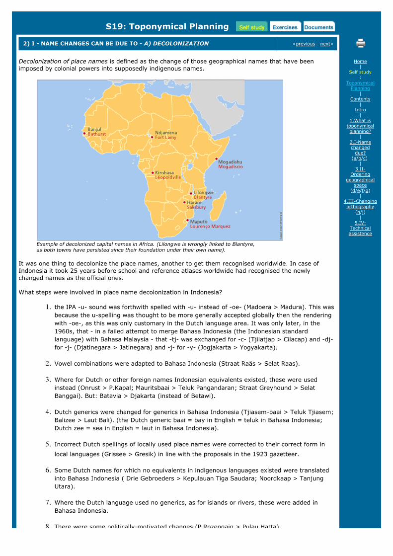
Decolonization of place names is defined as the change of those geographical names that have beenimposed by colonial powers into supposedly indigenous names.
Example of decolonized capital names in Africa. (Lilongwe is wrongly linked to Blantyre, as both towns have persisted since their foundation under their own name).
It was one thing to decolonize the place names, another to get them recognised worldwide. In case ofIndonesia it took 25 years before school and reference atlases worldwide had recognised the newlychanged names as the official ones.
What steps were involved in place name decolonization in Indonesia?
1. the IPA -u- sound was forthwith spelled with -u- instead of -oe- (Madoera > Madura). This wasbecause the u-spelling was thought to be more generally accepted globally then the renderingwith -oe-, as this was only customary in the Dutch language area. It was only later, in the1960s, that - in a failed attempt to merge Bahasa Indonesia (the Indonesian standardlanguage) with Bahasa Malaysia - that -tj- was exchanged for -c- (Tjilatjap > Cilacap) and -dj-for -j- (Djatinegara > Jatinegara) and -j- for -y- (Jogjakarta > Yogyakarta).
2. Vowel combinations were adapted to Bahasa Indonesia (Straat Raäs > Selat Raas).
3. Where for Dutch or other foreign names Indonesian equivalents existed, these were usedinstead (Onrust > P.Kapal; Mauritsbaai > Teluk Pangandaran; Straat Greyhound > SelatBanggai). But: Batavia > Djakarta (instead of Betawi).
4. Dutch generics were changed for generics in Bahasa Indonesia (Tjiasem-baai > Teluk Tjiasem;Balizee > Laut Bali). (the Dutch generic baai = bay in English = teluk in Bahasa Indonesia;Dutch zee = sea in English = laut in Bahasa Indonesia).
5. Incorrect Dutch spellings of locally used place names were corrected to their correct form inlocal languages (Grissee > Gresik) in line with the proposals in the 1923 gazetteer.
6. Some Dutch names for which no equivalents in indigenous languages existed were translatedinto Bahasa Indonesia ( Drie Gebroeders > Kepulauan Tiga Saudara; Noordkaap > TanjungUtara).
7. Where the Dutch language used no generics, as for islands or rivers, these were added inBahasa Indonesia.
8. There were some politically-motivated changes (P.Rozengain > Pulau Hatta).
Home|
Self study:
ToponymicalPlanning
|Contents
|Intro
|1.What is
toponymicalplanning?
|2.I-Namechanged
due?(a/b/c)
|3.II-
Orderinggeographical
space(d/e/f/g)
|4.III-Changingorthography
(h/i)|
5.IV-Technicalassistence
8. There were some politically-motivated changes (P.Rozengain > Pulau Hatta).
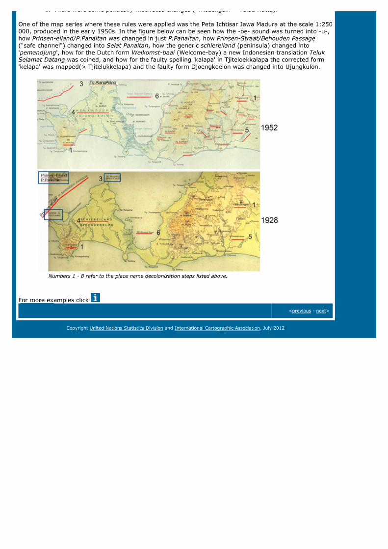
One of the map series where these rules were applied was the Peta Ichtisar Jawa Madura at the scale 1:250000, produced in the early 1950s. In the figure below can be seen how the -oe- sound was turned into -u-,how Prinsen-eiland/P.Panaitan was changed in just P.Panaitan, how Prinsen-Straat/Behouden Passage("safe channel") changed into Selat Panaitan, how the generic schiereiland (peninsula) changed into'pemandjung', how for the Dutch form Welkomst-baai (Welcome-bay) a new Indonesian translation TelukSelamat Datang was coined, and how for the faulty spelling 'kalapa' in Tjiteloekkalapa the corrected form'kelapa' was mapped(> Tjitelukkelapa) and the faulty form Djoengkoelon was changed into Ujungkulon.
Numbers 1 - 8 refer to the place name decolonization steps listed above.
For more examples click
<previous - next>
Copyright United Nations Statistics Division and International Cartographic Association, July 2012
additonal information
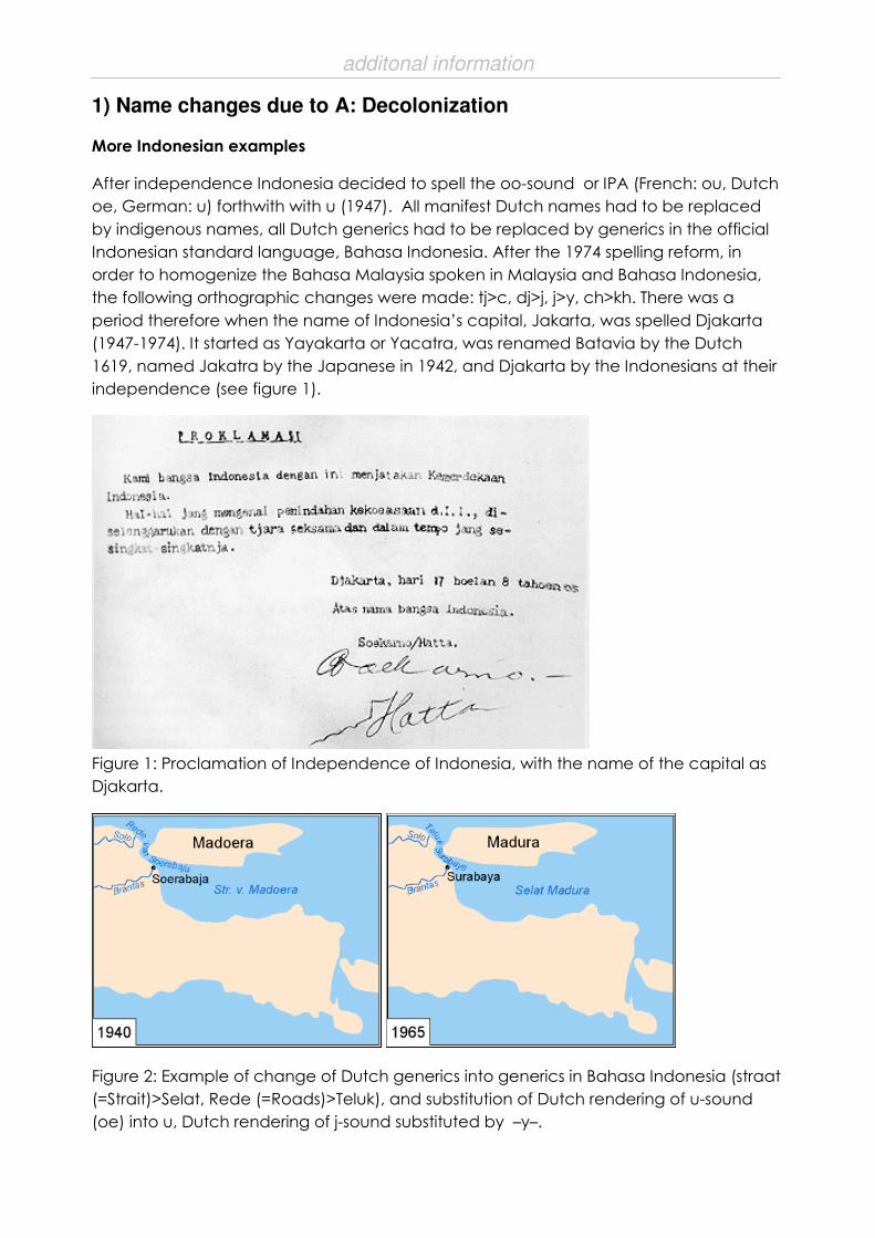
1) Name changes due to A: Decolonization
More Indonesian examples
After independence Indonesia decided to spell the oo-sound or IPA (French: ou, Dutch
oe, German: u) forthwith with u (1947). All manifest Dutch names had to be replaced
by indigenous names, all Dutch generics had to be replaced by generics in the official
Indonesian standard language, Bahasa Indonesia. After the 1974 spelling reform, in
order to homogenize the Bahasa Malaysia spoken in Malaysia and Bahasa Indonesia,
the following orthographic changes were made: tj>c, dj>j, j>y, ch>kh. There was a
period therefore when the name of Indonesia’s capital, Jakarta, was spelled Djakarta
(1947-1974). It started as Yayakarta or Yacatra, was renamed Batavia by the Dutch
1619, named Jakatra by the Japanese in 1942, and Djakarta by the Indonesians at their
independence (see figure 1).
Figure 1: Proclamation of Independence of Indonesia, with the name of the capital as
Djakarta.
Figure 2: Example of change of Dutch generics into generics in Bahasa Indonesia (straat
(=Strait)>Selat, Rede (=Roads)>Teluk), and substitution of Dutch rendering of u-sound
(oe) into u, Dutch rendering of j-sound substituted by –y–.

additonal information
An example of the language planning that went into the decolonisation of Indonesian
placenames is the list of Dutch toponyms or toponyms with Dutch generics, that had to
be changed (figure 3).
Figure 3: List of Dutch names or names with Dutch generics prepared by the
Topographical Survey in Djakarta in 950, to be changed into Indonesian names.

additonal information
The Dutch toponyms in Indonesia, did not quite change in the way the Dutch had
envisaged. Before independence, native editions of school atlases existed, which
rendered the capital as Betawi instead of Batavia, an adaptation of the name into
Bahasa Indonesia; as most Dutch names already had an Indonesian version as well,
Buitenzorg (the residence of the Governor-general) was already known by its Indonesian
name Bogor at the time (see figures 4-6).
Figure 4: Dutch school atlas, 1935: Batavia, Buitenzorg/Bogor, Dutch generics.
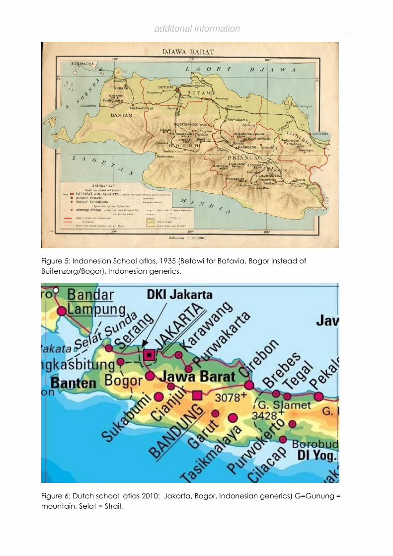
additonal information
Figure 5: Indonesian School atlas, 1935 (Betawi for Batavia, Bogor instead of
Buitenzorg/Bogor), Indonesian generics.
Figure 6: Dutch school atlas 2010: Jakarta, Bogor, Indonesian generics) G=Gunung =
mountain, Selat = Strait.

additonal information
Figures 7 and 8: Changes in street names 1940-2010.
S19: Toponymical Planning
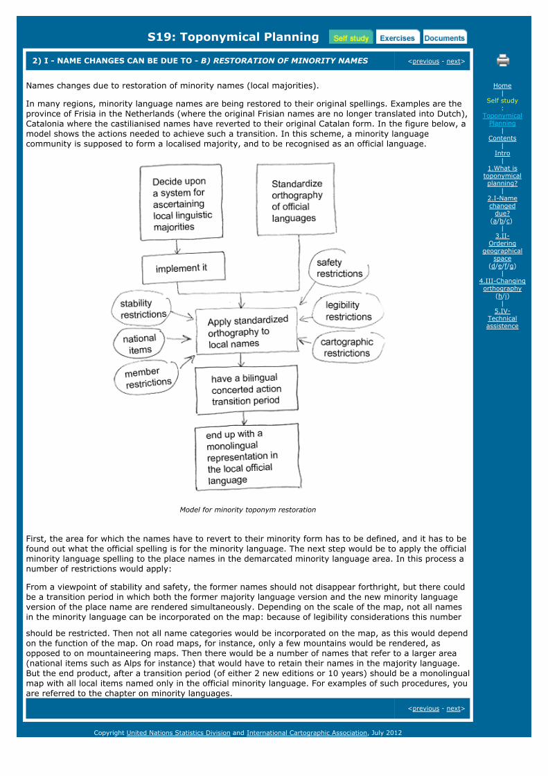
2) I - NAME CHANGES CAN BE DUE TO - B) RESTORATION OF MINORITY NAMES <previous - next>
Names changes due to restoration of minority names (local majorities).
In many regions, minority language names are being restored to their original spellings. Examples are theprovince of Frisia in the Netherlands (where the original Frisian names are no longer translated into Dutch),Catalonia where the castilianised names have reverted to their original Catalan form. In the figure below, amodel shows the actions needed to achieve such a transition. In this scheme, a minority languagecommunity is supposed to form a localised majority, and to be recognised as an official language.
Model for minority toponym restoration
First, the area for which the names have to revert to their minority form has to be defined, and it has to befound out what the official spelling is for the minority language. The next step would be to apply the officialminority language spelling to the place names in the demarcated minority language area. In this process anumber of restrictions would apply:
From a viewpoint of stability and safety, the former names should not disappear forthright, but there couldbe a transition period in which both the former majority language version and the new minority languageversion of the place name are rendered simultaneously. Depending on the scale of the map, not all namesin the minority language can be incorporated on the map: because of legibility considerations this number
should be restricted. Then not all name categories would be incorporated on the map, as this would dependon the function of the map. On road maps, for instance, only a few mountains would be rendered, asopposed to on mountaineering maps. Then there would be a number of names that refer to a larger area(national items such as Alps for instance) that would have to retain their names in the majority language.But the end product, after a transition period (of either 2 new editions or 10 years) should be a monolingualmap with all local items named only in the official minority language. For examples of such procedures, youare referred to the chapter on minority languages.
<previous - next>
Home|
Self study:
ToponymicalPlanning
|Contents
|Intro
|1.What is
toponymicalplanning?
|2.I-Namechanged
due?(a/b/c)
|3.II-
Orderinggeographical
space(d/e/f/g)
|4.III-Changingorthography
(h/i)|
5.IV-Technicalassistence
Copyright United Nations Statistics Division and International Cartographic Association, July 2012

S19: Toponymical Planning
2) I - NAME CHANGES CAN BE DUE TO - C) NEW ADMINISTRATIVE NAMES <previous - next>
The advisory committee on geographical names in the Netherlands, that operated under the RoyalNetherlands Academy of Arts and Sciences, employs the following criteria in its judgement or selection ofnew (municipality) names (when existing municipalities are merged) in the Netherlands:
New names should preferably be written according to the current orthographic rules
New names should not have been entered in current lists or indexes of names or brands
Constructions in which existing names are strung together (with or without hyphens) should beavoided
New names should reflect the history or historical geography of the region
Avoid sensibilities by selecting a completely new name instead of promoting existing names for amunicipality
Avoid as a new name for the joined municipalities constructions that link parts of existing names
It is only feasible to opt for the name of the largest municipality when a number of smallermunicipalities have been joined to one larger one
A new name should not be too similar to an existing geographical name either in the Netherlands orin neighbouring areas
New names should not bear negative connotations
For all new names it is important that there is a sufficient basis of support. It may be opportune to inviteentries for the best name in a contest, as this may deliver suitable new names. Practice proves, however,that most names offered are unsuitable, and the basis for the acceptance of new names may beendangered if parties have identified too much with the names offered for the contest. When selecting andimplementing new names it would be wise to test the alternatives by checking them for practical criteria,and subsequently by informing the public regarding the outcome of these tests. This also helps in theargumentation afterwards , if the proposed names are being subjected to a referendum.
<previous - next>
Home|
Self study:
ToponymicalPlanning
|Contents
|Intro
|1.What is
toponymicalplanning?
|2.I-Namechanged
due?(a/b/c)
|3.II-
Orderinggeographical
space(d/e/f/g)
|4.III-Changingorthography
(h/i)|
5.IV-Technicalassistence
Copyright United Nations Statistics Division and International Cartographic Association, July 2012

S19: Toponymical Planning
3) II) ORDERING GEOGRAPHICAL SPACE <previous - next>
In order to be able to refer to areas newly opened up for colonisation, habitation or residential use, nameshave to be applied to these areas. The same goes for areas that have been recently explored. Arctic andAntarctic exploration show examples of naming the newly discovered seas beneath the land ice, and themountains and hills beneath the (Ant)Arctic ice caps. We will deal with these examples under the followingheadings:
D) Naming of seas
E) Giving names to future objects in reclaimed areas
F) Urban street naming
G) Commemorative policies
In the following these aspects will be clarified.
<previous - next>
Home|
Self study:
ToponymicalPlanning
|Contents
|Intro
|1.What is
toponymicalplanning?
|2.I-Namechanged
due?(a/b/c)
|3.II-
Orderinggeographical
space(d/e/f/g)
|4.III-Changingorthography
(h/i)|
5.IV-Technicalassistence
Copyright United Nations Statistics Division and International Cartographic Association, July 2012
S19: Toponymical Planning
3) II) ORDERING GEOGR. SPACE - D) NAMING OF SEAS <previous - next>
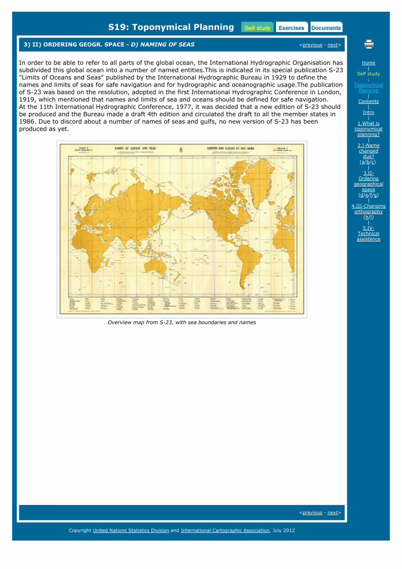
In order to be able to refer to all parts of the global ocean, the International Hydrographic Organisation hassubdivided this global ocean into a number of named entities.This is indicated in its special publication S-23"Limits of Oceans and Seas" published by the International Hydrographic Bureau in 1929 to define thenames and limits of seas for safe navigation and for hydrographic and oceanographic usage.The publicationof S-23 was based on the resolution, adopted in the first International Hydrographic Conference in London,1919, which mentioned that names and limits of sea and oceans should be defined for safe navigation. At the 11th International Hydrographic Conference, 1977, it was decided that a new edition of S-23 shouldbe produced and the Bureau made a draft 4th edition and circulated the draft to all the member states in1986. Due to discord about a number of names of seas and gulfs, no new version of S-23 has beenproduced as yet.
Overview map from S-23, with sea boundaries and names
<previous - next>
Home|
Self study:
ToponymicalPlanning
|Contents
|Intro
|1.What is
toponymicalplanning?
|2.I-Namechanged
due?(a/b/c)
|3.II-
Orderinggeographical
space(d/e/f/g)
|4.III-Changingorthography
(h/i)|
5.IV-Technicalassistence
Copyright United Nations Statistics Division and International Cartographic Association, July 2012
S19: Toponymical Planning
3) II) ORDERING GEOGR. SPACE - E) FUTURE OBJECTS IN RECLAIMED AREAS <previous - next>
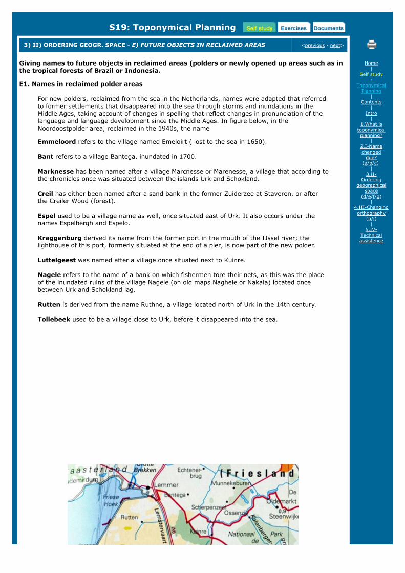
Giving names to future objects in reclaimed areas (polders or newly opened up areas such as inthe tropical forests of Brazil or Indonesia.
E1. Names in reclaimed polder areas
For new polders, reclaimed from the sea in the Netherlands, names were adapted that referredto former settlements that disappeared into the sea through storms and inundations in theMiddle Ages, taking account of changes in spelling that reflect changes in pronunciation of thelanguage and language development since the Middle Ages. In figure below, in theNoordoostpolder area, reclaimed in the 1940s, the name
Emmeloord refers to the village named Emeloirt ( lost to the sea in 1650).
Bant refers to a village Bantega, inundated in 1700.
Marknesse has been named after a village Marcnesse or Marenesse, a village that according tothe chronicles once was situated between the islands Urk and Schokland.
Creil has either been named after a sand bank in the former Zuiderzee at Staveren, or afterthe Creiler Woud (forest).
Espel used to be a village name as well, once situated east of Urk. It also occurs under thenames Espelbergh and Espelo.
Kraggenburg derived its name from the former port in the mouth of the IJssel river; thelighthouse of this port, formerly situated at the end of a pier, is now part of the new polder.
Luttelgeest was named after a village once situated next to Kuinre.
Nagele refers to the name of a bank on which fishermen tore their nets, as this was the placeof the inundated ruins of the village Nagele (on old maps Naghele or Nakala) located oncebetween Urk and Schokland lag.
Rutten is derived from the name Ruthne, a village located north of Urk in the 14th century.
Tollebeek used to be a village close to Urk, before it disappeared into the sea.
Home|
Self study:
ToponymicalPlanning
|Contents
|Intro
|1.What is
toponymicalplanning?
|2.I-Namechanged
due?(a/b/c)
|3.II-
Orderinggeographical
space(d/e/f/g)
|4.III-Changingorthography
(h/i)|
5.IV-Technicalassistence

Names in an area newly reclaimed from the sea (Noordoostpolder, the Netherlands)
Other examples of language planning
E2)Language planning in transmigrasi projects, Indonesia
In Indonesia, the surplus agrarian population of Java is resettled in less densely inhabitedislands, like Sumatra, Borneo, Celebes or New Guinea. This supervised migration process istermed 'transmigrasi' locally. Here is a text that shows some considerations for naming the newsettlements: in the Lampung area in Southern Sumatra) that had to be cleared first in thedense tropical forests (Benoit and Pain, 1989) :
"The present-day Kecamatan of Trimurjo bears witness to this heroic past. In 1935,'Kolonisatie' was implemented; the program was so successful that the Japanese, who wereseeking any means of supplying their troops, decided to continue it after the Dutch Indiessurrendered on March 9, 1942. Toponymy has provided a grasp of the environment, thedifficulties and the hopes of the settlers. Simbarwaringin and Limanbenawi indicate a heavilyforested environment: simbar signifies "two"and waringin means "banyan"; liman "elephant"and benawi "swamp". Other toponyms indicate the settlers'desperate hopes: Depokrejo means"the agreeable and lively place to live"; Adipura can be translated as "the safest place". Finally,some names evoke the difficult installation cionditions: Trimurjo means "three canals" (locatedat the junction of three secondary canals); Purwodadi, "the village being built".
E3) Language planning at the colonisation frontier in BrazilFigure below, shows the first subdivision of Brazil in the 16th century, in 15 captaincies, nearlyall with religious names, a few only have Tupi names, like Itamaraca, Pernambuco and Ceara.After this first layer of colonist names, on the coast, with mainly Portuguese religious anddescriptive names, the exploration of the interior gradually started, by the mixed descendantsof the Portuguese and the Tupi Indians, who spoke the Tupi language. In the 18th century theTupi language was banned, although it kept being spoken unto the middle of the 19th centuryin some states. By then this second layer of names, generated by these explorers in the nativeTupi languages, had chrystallized.
The third layer was one of Portuguese names: In the 18th century inland exploration of thepresent state Minas Gerais started. Here minerals were found and mined, and towns developed,named accordingly: Diamantina, Minas de Rio de Contas, Minas Novas are examples. Thisurbanised colonisation started in 1711 with Vila Rica de Ouro Preto, followed by São João DelRei (1713), and São José do Rio das Mortes (1717). For other inland areas colonists from Europe or from the Azores islands were attracted -especially in the south where these settlements were also set up in order to back Portugal'sclaim to this area in border disputes with Spain. Apart from the Tupi name Curitiba, mostplacenames given in this colonisation drive were Portuguese, like Florianópolis (1675), RioGrande (1736), Porto Alegre (1742) and others, and helped keep Southern Brazil firmly underPortuguese control.
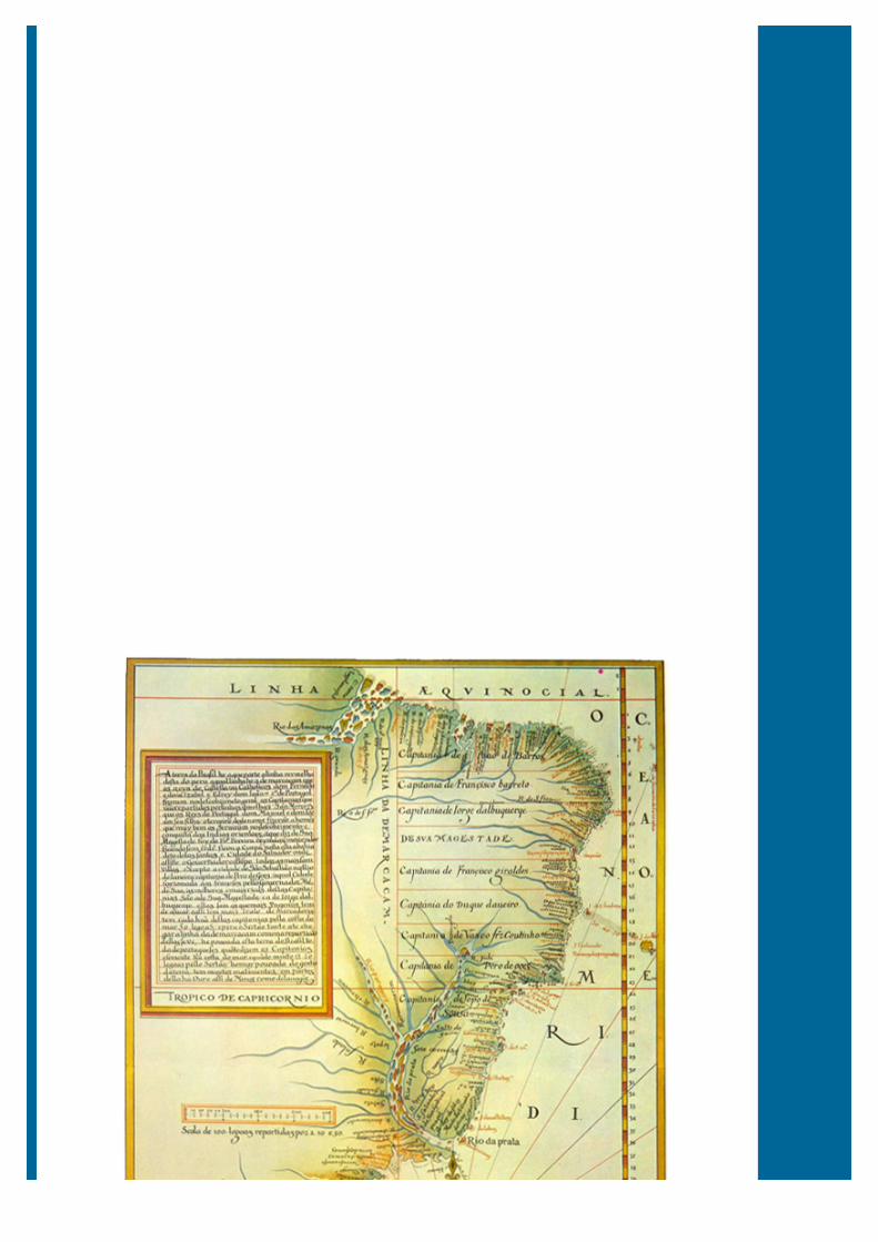

Portuguese map (1574) by Luís Teixeira, showing the location of the hereditary captaincies of Brazil.
Likewise in the second half of the 18th century there was a systematic policy of regionaloccupation through the constitution of a network of cities or villages named after cities back inPortugal: Chaves, Abrantes, Braganca, Obidos, Belmonte. Jesuit settlements with theirindigenous names lost not only the Jesuits when the Societas Jesu was disbanded in Brazil in1767 but also their names, as they were rebaptised ( Nova Almeida, Vila Flor, Trancoso areexamples),
Nowadays the occurrence of Tupi toponyms in the various Brazilian states does not necessarilyreflect the influence of the indigenous population or of Tupi-speaking explorers in the namingprocesses. It only shows that these names have Tupi etymology, but in fact they may havebeen given by non-Tupi speaking officials. Bustamante (2005) has shown that preference forproviding administrative territorial units with names of Tupi origin was stimulated in the period
1930-1945 when Getúlio Vargas was president, and a broad toponymic change was promoteddue to the so-called Geographical Law of Estado Novo (New State). Aiming at the systemicordering of the Brazilian administrative and territorial division, the federal governmentapproved this Law in 1938. Besides prohibiting the repetition of names of towns and districts, itrecommended "the preference to adopt regional names of the regional native language orrelated to historical facts of the region in case of replacement of toponyms" (IBGE, 1943, p.436).
More recently, this tendency is still alive; it is for instance visible in a recommendation includedin the laws of the National System of Nature Conservation Unit (Law n. 9.985, dated 18th July2000 and Decree n. 4.340, dated 22nd August 2002) to give preference to names of Indianancestors in the choice for the designation of federal conservation units. According to article 3,"the denomination of each conservation unit should be based, preferably, on its mostsignificant natural feature, or on its oldest denomination, giving priority, in this case, to thedesignations of the Indian ancestors" (2004, p.37).
<previous - next>
Copyright United Nations Statistics Division and International Cartographic Association, July 2012
S19: Toponymical Planning
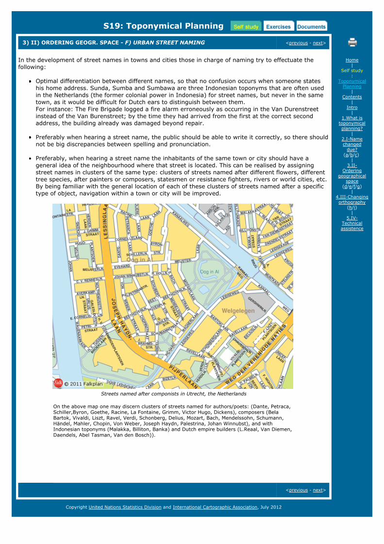
3) II) ORDERING GEOGR. SPACE - F) URBAN STREET NAMING <previous - next>
In the development of street names in towns and cities those in charge of naming try to effectuate thefollowing:
Optimal differentiation between different names, so that no confusion occurs when someone stateshis home address. Sunda, Sumba and Sumbawa are three Indonesian toponyms that are often usedin the Netherlands (the former colonial power in Indonesia) for street names, but never in the sametown, as it would be difficult for Dutch ears to distinguish between them.For instance: The Fire Brigade logged a fire alarm erroneously as occurring in the Van Durenstreetinstead of the Van Burenstreet; by the time they had arrived from the first at the correct secondaddress, the building already was damaged beyond repair.
Preferably when hearing a street name, the public should be able to write it correctly, so there shouldnot be big discrepancies between spelling and pronunciation.
Preferably, when hearing a street name the inhabitants of the same town or city should have ageneral idea of the neighbourhood where that street is located. This can be realised by assigningstreet names in clusters of the same type: clusters of streets named after different flowers, differenttree species, after painters or composers, statesmen or resistance fighters, rivers or world cities, etc.By being familiar with the general location of each of these clusters of streets named after a specifictype of object, navigation within a town or city will be improved.
Streets named after componists in Utrecht, the Netherlands
On the above map one may discern clusters of streets named for authors/poets: (Dante, Petraca,Schiller,Byron, Goethe, Racine, La Fontaine, Grimm, Victor Hugo, Dickens), composers (BelaBartok, Vivaldi, Liszt, Ravel, Verdi, Schonberg, Delius, Mozart, Bach, Mendelssohn, Schumann,Händel, Mahler, Chopin, Von Weber, Joseph Haydn, Palestrina, Johan Winnubst), and withIndonesian toponyms (Malakka, Billiton, Banka) and Dutch empire builders (L.Reaal, Van Diemen,Daendels, Abel Tasman, Van den Bosch)).
<previous - next>
Home|
Self study:
ToponymicalPlanning
|Contents
|Intro
|1.What is
toponymicalplanning?
|2.I-Namechanged
due?(a/b/c)
|3.II-
Orderinggeographical
space(d/e/f/g)
|4.III-Changingorthography
(h/i)|
5.IV-Technicalassistence
Copyright United Nations Statistics Division and International Cartographic Association, July 2012

S19: Toponymical Planning
3) II) ORDERING GEOGR. SPACE - G) COMMEMORATIVE POLICIES <previous - next>
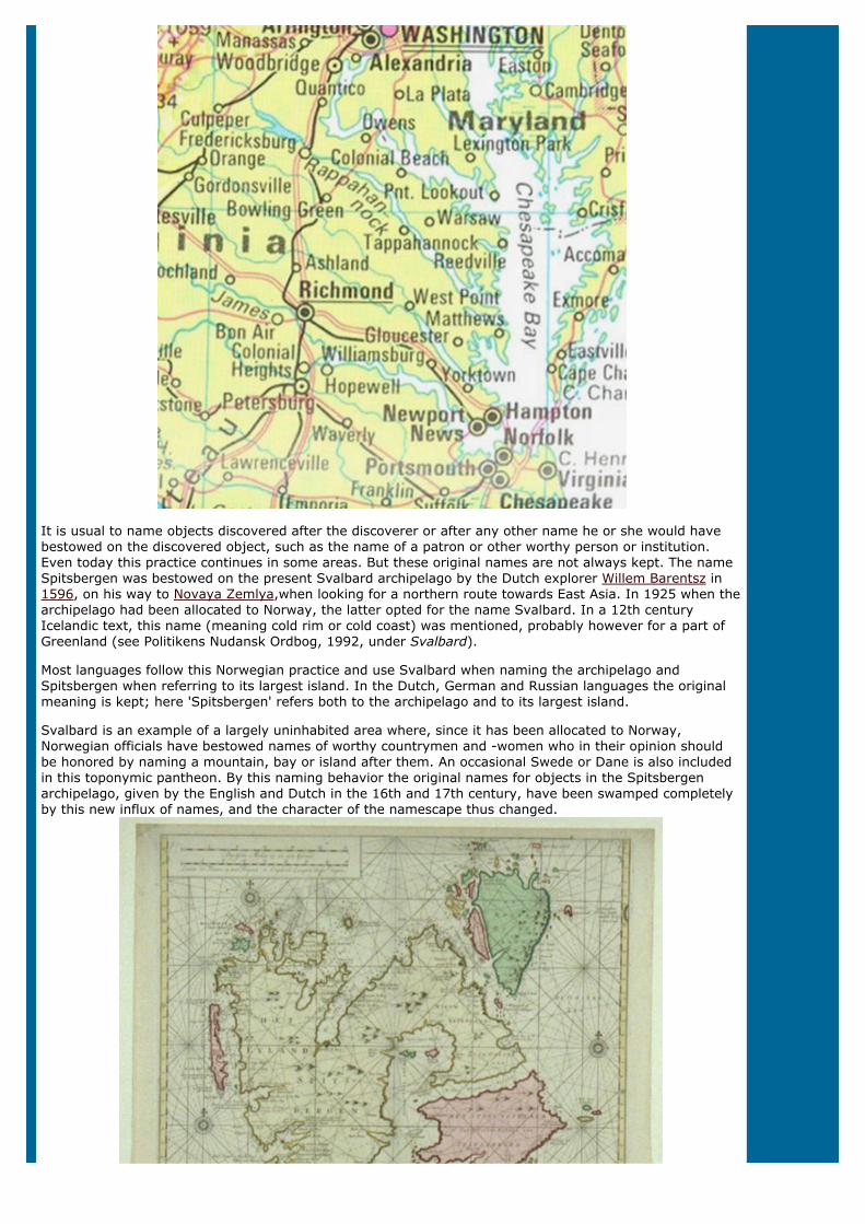
Virginia
In Virginia, the land of Pocahontas, there initially was a good rapport between the English colonists and thelocal Indians. This is reflected in the early maps of the region drawn by John Smith (1612): apart from twoEnglish names all the names are clearly Indian (see map above).
Later on, without any conscious effort to exchange names of Indian derivation for those given by colonists,the namescape of Virginia changed completely (see map below). When we look at a current map introducedby the National Geographic, it is English language names that stand out; the only name category that haspreserved its Indian character is that of the river names: e.g. Chesaspeake, and Rappahannock. The onlynative place name still rendered seems to be Tappahannock. So, even if this was not the result of namesplanning it is a complete change of the namescape.
Home|
Self study:
ToponymicalPlanning
|Contents
|Intro
|1.What is
toponymicalplanning?
|2.I-Namechanged
due?(a/b/c)
|3.II-
Orderinggeographical
space(d/e/f/g)
|4.III-Changingorthography
(h/i)|
5.IV-Technicalassistence
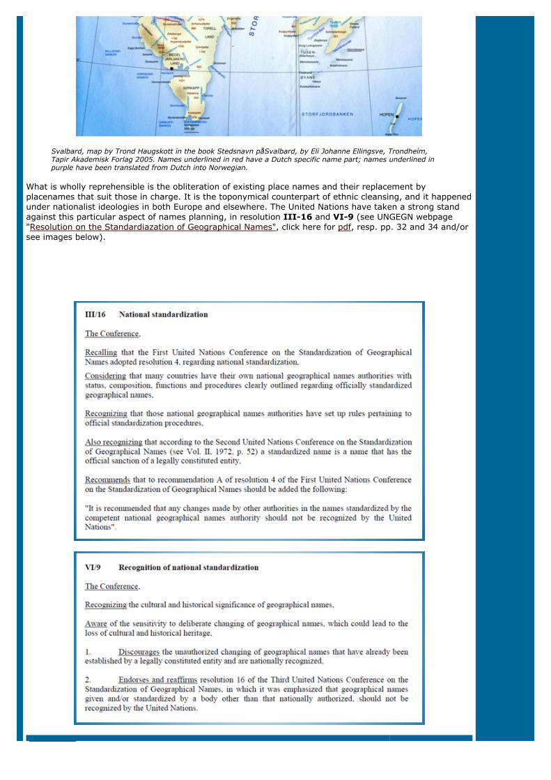
It is usual to name objects discovered after the discoverer or after any other name he or she would havebestowed on the discovered object, such as the name of a patron or other worthy person or institution.Even today this practice continues in some areas. But these original names are not always kept. The nameSpitsbergen was bestowed on the present Svalbard archipelago by the Dutch explorer Willem Barentsz in1596, on his way to Novaya Zemlya,when looking for a northern route towards East Asia. In 1925 when thearchipelago had been allocated to Norway, the latter opted for the name Svalbard. In a 12th centuryIcelandic text, this name (meaning cold rim or cold coast) was mentioned, probably however for a part ofGreenland (see Politikens Nudansk Ordbog, 1992, under Svalbard).
Most languages follow this Norwegian practice and use Svalbard when naming the archipelago andSpitsbergen when referring to its largest island. In the Dutch, German and Russian languages the originalmeaning is kept; here 'Spitsbergen' refers both to the archipelago and to its largest island.
Svalbard is an example of a largely uninhabited area where, since it has been allocated to Norway,Norwegian officials have bestowed names of worthy countrymen and -women who in their opinion shouldbe honored by naming a mountain, bay or island after them. An occasional Swede or Dane is also includedin this toponymic pantheon. By this naming behavior the original names for objects in the Spitsbergenarchipelago, given by the English and Dutch in the 16th and 17th century, have been swamped completelyby this new influx of names, and the character of the namescape thus changed.
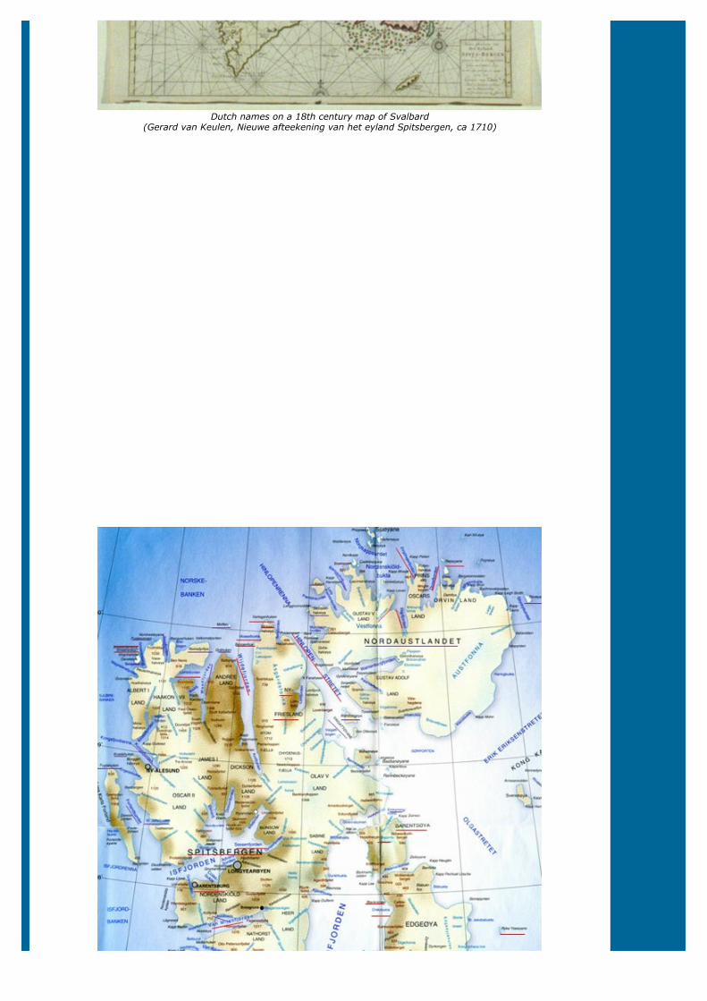
Dutch names on a 18th century map of Svalbard(Gerard van Keulen, Nieuwe afteekening van het eyland Spitsbergen, ca 1710)
Svalbard, map by Trond Haugskott in the book Stedsnavn påSvalbard, by Eli Johanne Ellingsve, Trondheim,Tapir Akademisk Forlag 2005. Names underlined in red have a Dutch specific name part; names underlined inpurple have been translated from Dutch into Norwegian.
What is wholly reprehensible is the obliteration of existing place names and their replacement byplacenames that suit those in charge. It is the toponymical counterpart of ethnic cleansing, and it happenedunder nationalist ideologies in both Europe and elsewhere. The United Nations have taken a strong standagainst this particular aspect of names planning, in resolution III-16 and VI-9 (see UNGEGN webpage"Resolution on the Standardiazation of Geographical Names", click here for pdf, resp. pp. 32 and 34 and/orsee images below).

<previous - next>
Copyright United Nations Statistics Division and International Cartographic Association, July 2012

S19: Toponymical Planning
4) III) CHANGING ORTHOGRAPHY <previous - next>
When spelling rules or orthographic rules change for a language, this can also have consequences for placenames in that language, as hundreds of place names might have to be adapted to the new rules. The samemight be necessary when attitudes change, or conversion methods between writing systems. We will lookat these issues under the following headings:
H) Application of new spelling rules
I) Opting for new attitudes (e.g. endonyms instead of exonyms)
These aspects will be clarified in the following pages.
<previous - next>
Home|
Self study:
ToponymicalPlanning
|Contents
|Intro
|1.What is
toponymicalplanning?
|2.I-Namechanged
due?(a/b/c)
|3.II-
Orderinggeographical
space(d/e/f/g)
|4.III-Changingorthography
(h/i)|
5.IV-Technicalassistence
Copyright United Nations Statistics Division and International Cartographic Association, July 2012
S19: Toponymical Planning
4) III) CHANGING ORTHOGRAPHY - H) APPLICATION OF NEW SPELLING RULES <previous - next>
Application of new spelling rules can make it necessary for toponymic databases to change hundreds oreven thousands of names in order to comply with the new orthographic rules. Examples of recentorthographic changes are those in Germany regarding:
ß and ss: In reformed orthography the grapheme ß is considered a separate letter that is to appear onlyafter long vowels and diphthongs. Otherwise it should be written ss.
Triple consonants preceding a vowel are no longer reduced (but hyphenation is often used in theseinstances anyway):
Flußschiffahrt Flussschifffahrt, Mißstand Missstand
Several loan words now allow spellings that are closer to the German norm. In particular, the affixes-phon, -phot, and -graph can be spelled with f for ph.
Although the new spelling rules do not apply to geographical names and personal names, they do apply toderived geographical names, for instance when used as adjectives. Application of all the ensuing changesmay severely tax the toponymic authorities, and call for some planning measures.
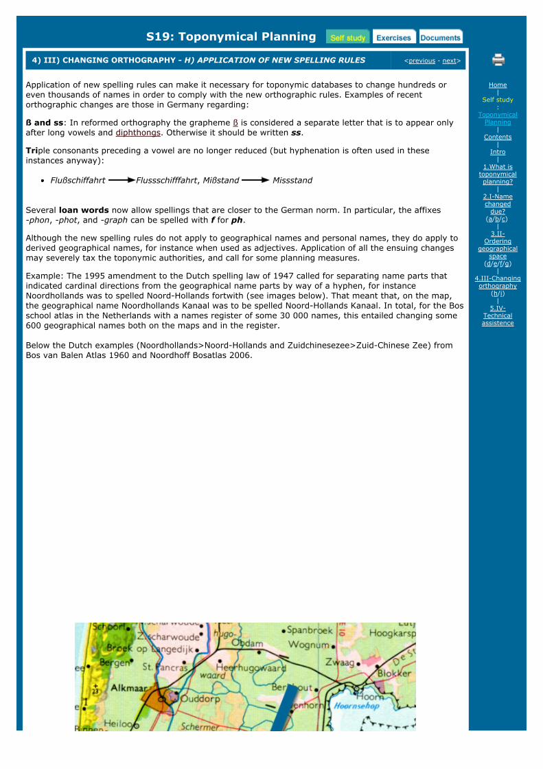
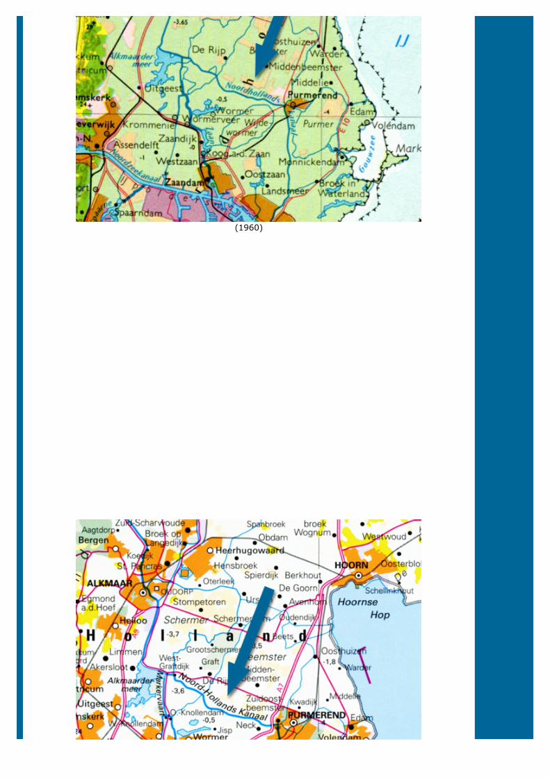
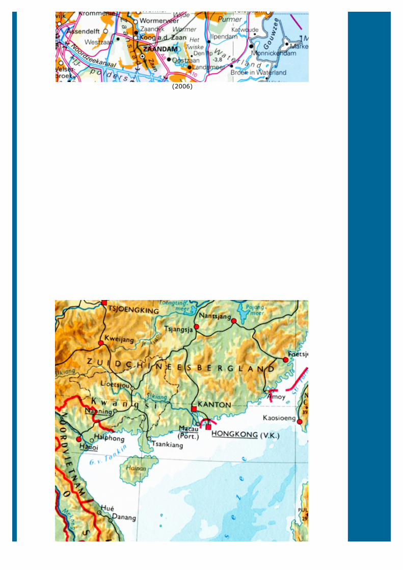
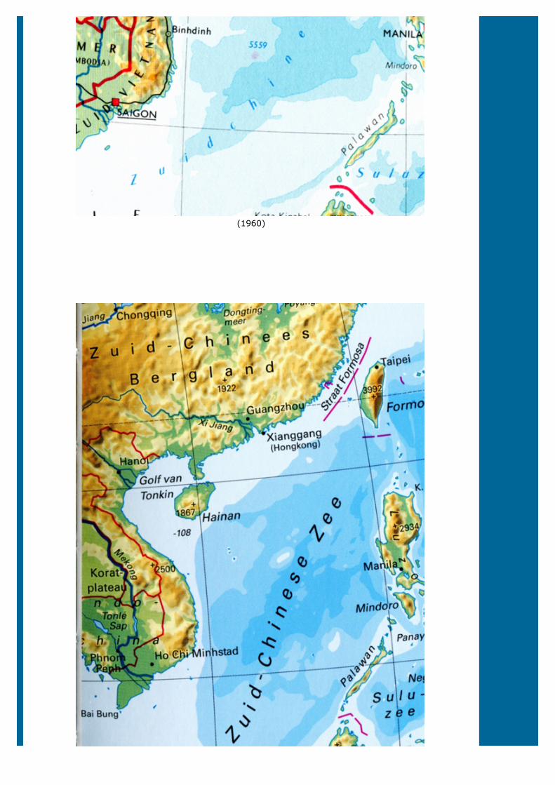
Example: The 1995 amendment to the Dutch spelling law of 1947 called for separating name parts thatindicated cardinal directions from the geographical name parts by way of a hyphen, for instanceNoordhollands was to spelled Noord-Hollands fortwith (see images below). That meant that, on the map,the geographical name Noordhollands Kanaal was to be spelled Noord-Hollands Kanaal. In total, for the Bosschool atlas in the Netherlands with a names register of some 30 000 names, this entailed changing some600 geographical names both on the maps and in the register.
Below the Dutch examples (Noordhollands>Noord-Hollands and Zuidchinesezee>Zuid-Chinese Zee) fromBos van Balen Atlas 1960 and Noordhoff Bosatlas 2006.
Home|
Self study:
ToponymicalPlanning
|Contents
|Intro
|1.What is
toponymicalplanning?
|2.I-Namechanged
due?(a/b/c)
|3.II-
Orderinggeographical
space(d/e/f/g)
|4.III-Changingorthography
(h/i)|
5.IV-Technicalassistence
(1960)
(2006)
(1960)

(2006)
<previous - next>
Copyright United Nations Statistics Division and International Cartographic Association, July 2012
S19: Toponymical Planning
4) III) CHANGING ORTHOGRAPHY - I) OPTING FOR NEW ATTITUDES <previous - next>
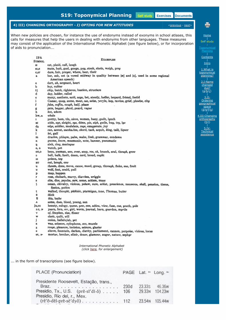
When new policies are chosen, for instance the use of endonyms instead of exonyms in school atlases, thiscalls for measures that help the users in dealing with endonyms from other languages. These measuresmay consist of the application of the International Phonetic Alphabet (see figure below), or for incorporationof aids to pronunciation...
International Phonetic Alphabet (click here, for enlargement)
... in the form of transcriptions (see figure below).
Home|
Self study:
ToponymicalPlanning
|Contents
|Intro
|1.What is
toponymicalplanning?
|2.I-Namechanged
due?(a/b/c)
|3.II-
Orderinggeographical
space(d/e/f/g)
|4.III-Changingorthography
(h/i)|
5.IV-Technicalassistence
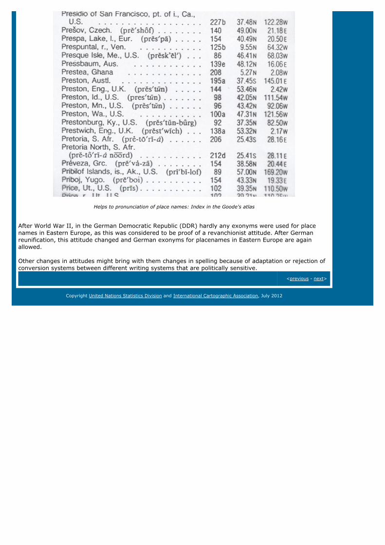
Helps to pronunciation of place names: Index in the Goode's atlas
After World War II, in the German Democratic Republic (DDR) hardly any exonyms were used for placenames in Eastern Europe, as this was considered to be proof of a revanchionist attitude. After Germanreunification, this attitude changed and German exonyms for placenames in Eastern Europe are againallowed.
Other changes in attitudes might bring with them changes in spelling because of adaptation or rejection ofconversion systems between different writing systems that are politically sensitive.
<previous - next>
Copyright United Nations Statistics Division and International Cartographic Association, July 2012

S19: Toponymical Planning
5) IV) NECESSARY TECHNICAL ASSISTENCE <previous
All these planned changes regarding place names have less success when they are not simultaneouslyapplied on both maps, signposts and place name signs. And if names are changed, these signs and mapsshould reflect the change by showing during a transition period, both versions of the name, so that thepublic can get used to the new name and see what object it refers to. This may be an expensive way to goabout the name changes, but in the end it may pay off by making the local inhabitants more receptive tothe proposed changes.
Names on place names signs and on the map should be rendered in the same way
The model in the figure below shows the same for both maps, name signs and signposts.
Home|
Self study:
ToponymicalPlanning
|Contents
|Intro
|1.What is
toponymicalplanning?
|2.I-Namechanged
due?(a/b/c)
|3.II-
Orderinggeographical
space(d/e/f/g)
|4.III-Changingorthography
(h/i)|
5.IV-Technicalassistence

Model of the concerted conversion of majority names to minority namesClick here, for enlargement
<previous
Copyright United Nations Statistics Division and International Cartographic Association, July 2012

E19: Toponymical Planning
AVAILABLE EXERCISES next>
Exercise 1: Adapt Colonial map to new dispensation (change names into present BahasaIndonesia spellings)
next>
Home|
Exercises:
ToponymicalPlanning
|1.Adapt
Colonial map tonew
dispensation
Copyright United Nations Statistics Division and International Cartographic Association, July 2012

E19: Toponymical Planning
EXERCISE 1: ADAPT COLONIAL MAP TO NEW DISPENSATION <previous
Adapt a Colonial map to new dispensation (change names into present Bahasa Indonesia spellings)
On the basis of the example, we described in "Name changes due to A) Colonization", you are asked to changethe spelling of the toponyms on this map of Sunda Straits from a Dutch language school atlas published about1930, into the properly spelled Bahasa Indonesia toponyms
Home|
Exercises:
ToponymicalPlanning
|1.Adapt
Colonial map tonew
dispensation

<previous
Copyright United Nations Statistics Division and International Cartographic Association, July 2012
E19: Toponymical Planning
EXERCISE 1: ADAPT COLONIAL MAP TO NEW DISPENSATION - ANSWERS <back to exercise 1
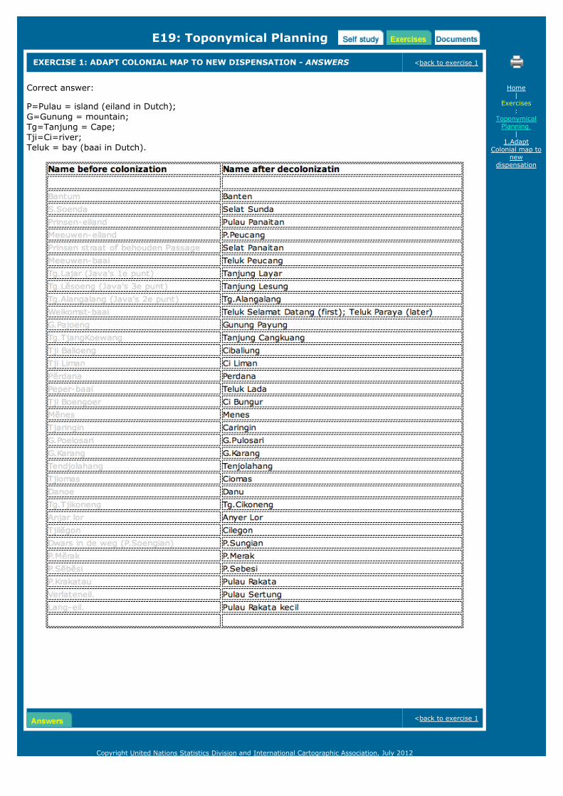
Correct answer:
P=Pulau = island (eiland in Dutch); G=Gunung = mountain; Tg=Tanjung = Cape;Tji=Ci=river; Teluk = bay (baai in Dutch).
<back to exercise 1
Home|
Exercises:
ToponymicalPlanning
|1.Adapt
Colonial map tonew
dispensation
Copyright United Nations Statistics Division and International Cartographic Association, July 2012

D19: Toponymical Planning
DOCUMENTS AND LITERATURE
Literature:
Benoit, D., Pain, M., and O. Sevin (1989). Transmigration and spontaneous migrations in Indonesia.Parris: Propinsi Lampung, Sumatera, Indonesia, with an Atlas of the Province of Lampung. Paris:ORSTOM and Jakarta: Departemen Transmigrasi, 1989. pp. 443. Illustrations, Maps, Tables.
Bustamante, A.M.G. (2005). Memoria e identidade local em Icapui. Tese de Doutorado. UFRJ.
Bustamente, A.M.G. (2007). Toponymy in languages of native peoples in Brazil. PaperE/CONF.98/98/Add.1, Ninth United Nations Conference on the Standardization of GeographicalNames, New York 2007.
Dick, M.V. (1990). Atlas Toponímico do Brasil. University of São Paulo.
IBGE 1943: Instituto Brasileiro de Geografia e estatistica (1939-1943). Divisao Territorial do Brasil.Rio de Janeiro.
Pessoa, J. and G. Piccinato (2007). Atlas do centros historicos do Brasil. Casa da Palavra: Rio deJaneiro.
Smith, C.C. (1993). The allocation of geographical names in an urban area: the determination ofnaming boundaries based on the Roodepoort experience: thematic areas in an alphabetic sequence.In P.S. Hattingh, N. Kadmon, P.E. Raper and I. Booysen (eds). Proceedings 1992 Training Course inToponymy for Southern Africa. Pretoria: Dept of Geography, University of Pretoria, pp 362-372.
Online resources:
The United Nations sell the following publications which also can be downloaded from theUNGEGN website:
Glossary of Terms for the Standardization of Geographical Names (New York 2002) / pdfManual for the national standardization of geographical names (UN - Ecosoc, New York,2006 ST/ESA/STAT/SERM/88 Sales No. E.06.XVII.7 ISBN 92-1-161490-2, available inthe 6 UN languages) / pdfTechnical reference manual for the standardization of geographical names (New York,2007) / pdfResolutions adopted at the nine UN Conferences on the standardization of geographicalnames (English (pdf) / French (pdf)
Home|
Documents:
ToponymicalPlanning
Copyright United Nations Statistics Division and International Cartographic Association, July 2012