Embed Size (px)
Citation preview
Roadkill Monitoring Report 1Janurary-30 March 2017Tarkine Drive Upgrade
April 2017
Department of State Growth
Tarkine Drive – Roadkill Monitoring Report – January-March 2017
This report details the results of roadkill monitoring activities for the Tarkine Drive over the first three-month period of 2017, and is the thirteenth report in total. The Commonwealth Government approved the project to proceed in line with a number of environmental conditions approved under the Environment Protection and Biodiversity Conservation Act 1999. Condition 11 of this approval requires that the Department of State Growth publish a roadkill monitoring report every three months, as part of the Draft Roadkill Monitoring Adaptive Management Plan (RMAMP), which details the results of monitoring activities.
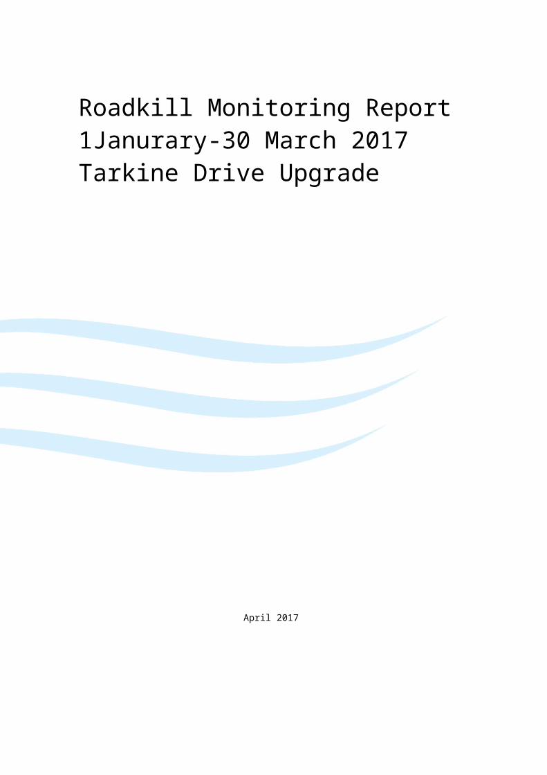
Tarkine Drive, a 92.7km road, is monitored weekly for signs of roadkill (see Image 1 below). All road upgrade works were completed in December 2014, with the road officially reopened in June 2015.
Image 1. Map of project area.
Data collected as part of these monitoring activities is based on pre-defined criteria outlined by the Approval. These criteria are:
Date and time of identification; Location (GPS coordinates); Species identified (all species are to be recorded); Body condition; and Any other notable circumstances.

Department of State Growth
Tarkine Drive – Roadkill Monitoring Report – January-March 2017
Monitoring results for this three-month period are detailed in appendices at the end of this report. Seven animals were recorded as roadkill during this period; no threatened species were recorded (see table in Appendix A). These results may be reflective of the normal seasonal variation of animal activity in this area, increased accessibility of the road due to the completion of road works or increased visitation to the area; nonetheless, these numbers are consistent with modelling developed prior to the upgrade and remain below the trigger thresholds outlined as part of the Approval.
All monitoring activities occur under a regular maintenance regime, specified in the RMAMP.
Roadkill remains an issue of particular concern for the area, and as such, a number of measures have been implemented as part of the construction project to minimise total roadkill numbers (See Appendix B). These measures include:
Reduced speed limits; Installation of audible ‘rumble’ strips at 26 separate locations; Use of light-coloured pavement in the road surface to improve visibility; Removal of roadside vegetation to reduce proximity of habitat to road; Installation of new table drains to reduce ponding of water at the roadside; Improved sight distance; Wildlife warning signs; and Regular monitoring and removal of roadkill to prevent other scavenger animals being attracted
to the road.
All of the above-listed measures have already been implemented and continue to be maintained. It is difficult to specifically appropriate reduced numbers of roadkill to a specific measure or circumstance. It is expected that the implementation of these roadkill mitigation measures has assisted in reducing the incidences of roadkill throughout known roadkill hotspots, however this is subject to significant variability in road use, road user behaviours and other chance factors.
Following the approval of the RMAMP, should total numbers of roadkill be found to be increasing, additional mitigation measures will be implemented at pre-existing or newly identified roadkill hotspot locations.
Department of State Growth
Tarkine Drive – Roadkill Monitoring Report – January-March 2017
Appendix A : Table of Results
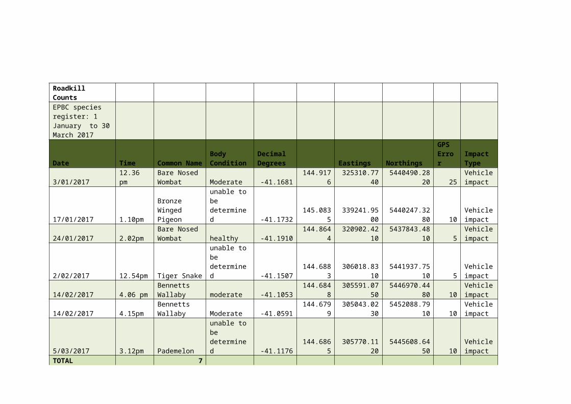
Roadkill Counts EPBC species register: 1 January to 30 March 2017
Date Time Common NameBody Condition
Decimal Degrees Eastings Northings
GPS Error
Impact Type
3/01/2017 12.36 pmBare Nosed Wombat Moderate -41.1681 144.9176 325310.7740 5440490.2820 25
Vehicle impact
17/01/2017 1.10pmBronze Winged Pigeon
unable to be determined -41.1732 145.0835 339241.9500 5440247.3280 10
Vehicle impact
24/01/2017 2.02pmBare Nosed Wombat healthy -41.1910 144.8644 320902.4210 5437843.4810 5
Vehicle impact
2/02/2017 12.54pm Tiger Snakeunable to be determined -41.1507 144.6883 306018.8310 5441937.7510 5
Vehicle impact
14/02/2017 4.06 pmBennetts Wallaby moderate -41.1053 144.6848 305591.0750 5446970.4480 10
Vehicle impact
14/02/2017 4.15pmBennetts Wallaby Moderate -41.0591 144.6799 305043.0230 5452088.7910 10
Vehicle impact
5/03/2017 3.12pm Pademelonunable to be determined -41.1176 144.6865 305770.1120 5445608.6450 10
Vehicle impact
TOTAL 7
Appendix B: Map of Installed Mitigation Measures