Embed Size (px)
Citation preview
Roadkill Monitoring Report – July to September 2015
Tarkine Drive Upgrade
October 2015
Department of State Growth
Tarkine Drive – Roadkill Monitoring Report – July to September 2015
This report details the results of roadkill monitoring activities for the Tarkine Drive over the third three-month period of 2015, and is the eighth report in total. The Commonwealth Government approved the project to proceed in line with a number of environmental conditions approved under the Environment Protection and Biodiversity Conservation Act 1999. Condition 11 of this approval requires that the Department of State Growth publish a roadkill monitoring report every three months, as part of the Draft Roadkill Monitoring Adaptive Management Plan (RMAMP), which details the results of monitoring activities.
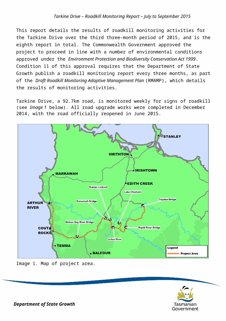
Tarkine Drive, a 92.7km road, is monitored weekly for signs of roadkill (see Image 1 below). All road upgrade works were completed in December 2014, with the road officially reopened in June 2015.
Image 1. Map of project area.
Data collected as part of these monitoring activities is based on pre-defined criteria outlined by the Approval. These criteria are:
Date and time of identification; Location (GPS coordinates);
Department of State Growth
Tarkine Drive – Roadkill Monitoring Report – July to September 2015
Species identified (all species are to be recorded); Body condition; and Any other notable circumstances.
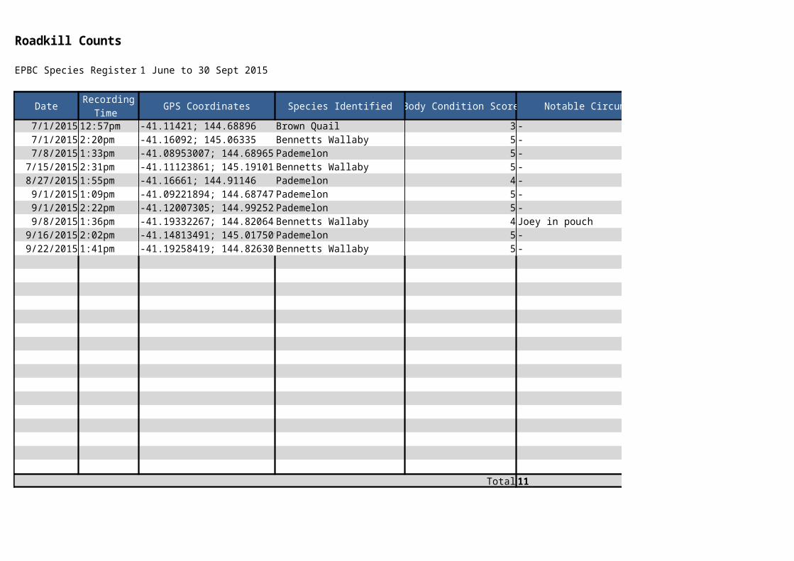
Monitoring results for this three-month period are detailed in appendices at the end of this report. 11 animals were recorded as roadkill during this period; no threatened species were recorded (see table in Appendix A). The locations of these species are displayed on the map in Appendix B. These results may be reflective of the normal seasonal variation of animal activity in this area, increased accessibility of the road due to the completion of road works or increased visitation to the area; nonetheless, these numbers are consistent with modelling developed prior to the upgrade and remain below the trigger thresholds outlined as part of the Approval.
All monitoring activities occur under a regular maintenance regime, specified in the RMAMP. This number is higher than the same reporting period last year. All monitoring activities occur under a regular maintenance regime, specified in the RMAMP. Monitoring was undertaken 14 times over this quarter. Monitoring occurs on any given day of the week, with each new week commencing on a Monday. This provides for a random sample of collection to ensure that results do not reflect any one particular pattern of behaviour by animals or motorists.
Roadkill remains an issue of particular concern for the area, and as such, a number of measures are have been implemented as part of the construction project to minimise total roadkill numbers. These measures include:
Reduced speed limits; Installation of audible ‘rumble’ strips at 26 separate locations; Use of light-coloured pavement in the road surface to improve visibility; Removal of roadside vegetation to reduce proximity of habitat to road; Installation of new table drains to reduce ponding of water at the roadside; Improved sight distance; Wildlife warning signs; and Regular monitoring and removal of roadkill to prevent other scavenger animals
being attracted to the road.
All of the above-listed measures have already been implemented and continue to be maintained. It is difficult to specifically appropriate reduced numbers of roadkill to a specific measure or circumstance. It is expected that the implementation of these roadkill mitigation measures have assisted in reducing the incidences of roadkill throughout known roadkill hotspots, however this is subject to significant variability in road use, road user behaviours and other chance factors.
Following the approval of the RMAMP, should total numbers of roadkill be found to be increasing, additional mitigation measures will be implemented at pre-existing or newly identified roadkill hotspot locations.

Department of State Growth
Tarkine Drive – Roadkill Monitoring Report – July to September 2015

Department of State Growth
Tarkine Drive – Roadkill Monitoring Report – July to September 2015
Appendix A : Table of Results

Roadkill Counts
EPBC Species Register: 1 June to 30 Sept 2015
Date GPS Coordinates Species Identified Body Condition Score Notable Circumstances
7/1/2015 12:57pm -41.11421; 144.68896 Brown Quail 3 -7/1/2015 2:20pm -41.16092; 145.06335 Bennetts Wallaby 5 -7/8/2015 1:33pm -41.08953007; 144.6896555Pademelon 5 -
7/15/2015 2:31pm -41.11123861; 145.1910128Bennetts Wallaby 5 -8/27/2015 1:55pm -41.16661; 144.91146 Pademelon 4 -
9/1/2015 1:09pm -41.09221894; 144.6874773Pademelon 5 -9/1/2015 2:22pm -41.12007305; 144.9925282Pademelon 5 -9/8/2015 1:36pm -41.19332267; 144.820648 Bennetts Wallaby 4 Joey in pouch
9/16/2015 2:02pm -41.14813491; 145.0175097Pademelon 5 -9/22/2015 1:41pm -41.19258419; 144.8263073Bennetts Wallaby 5 -
Total 11
Recording Time
Appendix B: Map of Roadkill Locations and Installed Mitigation Measures