Embed Size (px)
DESCRIPTION
8. RECREATION MANAGEMENT STRATEGIES ............................... 40 5. An assessment of the current tourism offer ............................ 17 9. Information, Signage and Interpretation ................................ 45 1.1 The Tarkine ................................................................... 3 1.2 The Purpose of the Tourism Master Plan ............................ 3 1.3 Approach to plan development ......................................... 3
Citation preview
TTaarrkkiinnee MMaasstteerr PPllaann ffoorr ppuubblliicc ccoommmmeenntt MMaarrcchh,, 22000088
TARKINE TOURISM MASTER PLAN
For public comment
March 2008
TTaarrkkiinnee MMaasstteerr PPllaann ffoorr ppuubblliicc ccoommmmeenntt MMaarrcchh,, 22000088 11
Table of contents
1. Introduction .............................................................................. 3
1.1 The Tarkine ................................................................... 3 1.2 The Purpose of the Tourism Master Plan ............................ 3 1.3 Approach to plan development ......................................... 3
2. The values of the Tarkine .......................................................... 5
2.1 Natural values ................................................................ 5 2.2 Cultural values ............................................................... 6 2.3 Current Recreational Use ................................................. 7
3. Tourism Context ....................................................................... 9
4. The Basis for the Tourism Master Plan .................................... 13
4.1 The vision for tourism ....................................................13 4.2 Guiding Principles ..........................................................14 4.3 The Tarkine Brand .........................................................14 4.4 The Target Market and their needs ..................................15
5. An assessment of the current tourism offer ............................ 17
5.1 Basis for assessment ......................................................17 5.2 Major Gaps ...................................................................21
6. TOURISM FRAMEWORK ........................................................... 24
7. Tourism Development ............................................................. 29
7.1 The Tarkine Experiences .................................................29 7.2. Tarkine Entry Points .......................................................30 7.3 Nodes ..........................................................................32 7.4 Corridors ......................................................................34 7.5 Visitor Attractions ..........................................................37 7.6 Visitor Sites ..................................................................38 7.7 Regional Linkages ..........................................................39 7.8 Landscapes ...................................................................39
8. RECREATION MANAGEMENT STRATEGIES ............................... 40
8.1 Bushwalking .................................................................40 8.2 Canoeing ......................................................................42 8.3 Cycling .........................................................................43 8.4 Four wheel driving .........................................................43 8.5 Other recreational activities ............................................44
9. Information, Signage and Interpretation ................................ 45
9.1 Overall approach to information ......................................45 9.2 Interpretation ...............................................................46
10. Tourism management ............................................................. 48
10.1 Land tenure ..................................................................48 10.2 Capacity building ...........................................................48 10.3 Environmental and cultural management ..........................48 10.4 Leases, Licences and Permits ..........................................48
TTaarrkkiinnee MMaasstteerr PPllaann ffoorr ppuubblliicc ccoommmmeenntt MMaarrcchh,, 22000088 22
10.5 Accreditation .................................................................49 10.6 Research and monitoring ................................................49 10.7 Presenting the Tarkine ...................................................50 10.8 Marketing .....................................................................50
11. Implementation Plan .............................................................. 51
12. References .............................................................................. 59
APPENDIX 1 ................................................................................. 60
TTaarrkkiinnee MMaasstteerr PPllaann ffoorr ppuubblliicc ccoommmmeenntt MMaarrcchh,, 22000088 33
1. Introduction
1.1 The Tarkine
The Tarkine is located in the north-west of Tasmania. The area has been loosely defined (for the purposes of tourism planning) as the area
bounded by the Murchison Highway in the east, the Arthur and Pieman Rivers to the north and south, and the coast.
The word Tarkine1 is adapted from the name of one of three bands of a
tribe of Aboriginal people once living in north-west Tasmania.2
The region hosts Australia's largest temperate rainforest, the largest area
of unprotected wilderness remaining in Tasmania and a range of other cultural, biological, geological, and landscape values. It includes the Arthur Pieman Conservation Area, Savage River National Park and a
number of forest reserves.
1.2 The Purpose of the Tourism Master Plan
This tourism master plan is being prepared to provide the basis for focused development of tourism.
The plan will propose:
The role, unique position and relevant experiences and opportunities that are recommended in relation to the brand;
The range of infrastructure, facilities, experiences, signage and interpretation that we believe is essential to achieve the agreed vision
and deliver on the brand;
The areas and issues that require detailed planning, assessment, design or management solutions;
Strategies for management of recreational activities (including 4wheel drive; fishing; bushwalking and others);
New business opportunities and attractors that need to be developed;
Quality assurance standards with respect to infrastructure, facility
and services investments and the training requirements to achieve such standards.
1.3 Approach to plan development
The preparation of this draft plan has involved a number of steps
Review of existing information about the area and its tourism market
and product;
1 The use of the word Tarkine to describe the region is not accepted by the entire community which needs to be resolved.
2 Tarkine Coalition website
TTaarrkkiinnee MMaasstteerr PPllaann ffoorr ppuubblliicc ccoommmmeenntt MMaarrcchh,, 22000088 44
Field visits and site inspections across the region;
Review of adjacent regions and their tourism opportunities;
Discussions with stakeholders
Community/industry workshops
Discussion with Tarkine Discussion Group
This Tourism Master Plan is being publicly released for comment and input
by interested stakeholders and the broader community who have interest in the tourism development of the Tarkine.
The Cradle Coast Authority will review comments received as part of the development of the final Tarkine Tourism Plan.
Comments may take the form of track changes within this document or
changes suggested in table or email.
Please forward comments to [email protected] by 30 April, 2008.
TTaarrkkiinnee MMaasstteerr PPllaann ffoorr ppuubblliicc ccoommmmeenntt MMaarrcchh,, 22000088 55
2. The values of the Tarkine
2.1 Natural values
The Tarkine area exhibits a wide range of highly significant natural values
which stem from its large size and its diverse and largely undisturbed ecosystems. Appendix Three contains a listing of threatened flora and
fauna species.
Landscape and wilderness
The succession of rugged and remote landscapes from coast to mountain retains a high degree of naturalness, free from human intrusion. The wild and exposed coastal strip contains spectacular contrasting areas of rocky
cliffs, long sandy beaches, sand dunes, boulder beaches, lagoons, salt marsh, and river estuaries. Extensive areas of dense heathland, open
grasslands and button-grass moorland occur further inland, while there are vast tracts of wet eucalypt forest and rainforest in the rugged river valleys and mountains in the east and south.
The size and naturalness of the area and its extensive un-roaded terrain result in high wilderness quality – large parts of the area being rated
highly in the National Wilderness Inventory. The catchments of many of the area‟s numerous rivers remain remote and undisturbed and, except for the Savage and Pieman Rivers in the south, remain free of major dams
and intrusions. Several spectacular waterfalls occur on the area‟s wild rivers.
Geological significance
There are numerous areas of geological significance in the Tarkine. Examples include:
a large proportion of Tasmania‟s peat soil blanket bogs, which are significant globally;
the Sandy Cape dune fields, which are one of the largest relatively undisturbed dune areas in Tasmania;
relict rock platforms, sand dunes and marine platforms in the Norfolk
Range area, which are significant for studying past changes in sea levels;
rare magnesite karst formations, potentially of global significance;
stromatolite fossils, which are among the oldest fossils in Tasmania.
Vegetation
The Tarkine‟s diverse ecosystems contain a rich variety of vegetation communities of high conservation significance - in particular, rare or
uncommon old growth eucalypt forest and rainforest, button-grass moorland and sphagnum communities. The cool temperate rainforest in
the Savage River and Meredith Range areas include the largest undisturbed tract of temperate rainforest in Australia and some of the tallest and best examples of old growth rainforest in Tasmania.
Botanically, this rainforest is considered to be of international significance.
TTaarrkkiinnee MMaasstteerr PPllaann ffoorr ppuubblliicc ccoommmmeenntt MMaarrcchh,, 22000088 66
As well as its extensive area and undisturbed condition, it contains a high diversity of rainforest vegetation communities and provides major refuge
for rainforest species, including Myrtle (Nothofagus cunninghamii)-dominated rainforest.
The area has a considerable diversity of plant species, including species endemic to the Tarkine or Tasmania‟s west coast and species at the limits of their distributional range. The latter includes the northern limit of the
rare, long-lived and slow-growing Huon Pine (Lagarostrobus franklinii) in the Pieman River area. Twenty-three of the area‟s plant species are
classified as rare or threatened.
Fauna
A large number of animal species occur in the Tarkine, at least 247
species (vertebrate and invertebrate) having been identified so far. It serves as a refuge for a number of vertebrate species which have
experienced population declines in other parts of Tasmania and the Australian mainland. The area also contains key habitat for numerous rare or threatened animal species. Of particular note is the coastal strip.
As well as providing breeding habitat for shore birds threatened elsewhere in Australia, it comprises a significant part of the migratory corridor for
the Endangered Orange-Bellied Parrot (Neophema chrysogaster)on its journey from its breeding grounds in south-west Tasmania to Victoria and
South Australia.
Significant animals of the buttongrass moorland include the Ground Parrot (Pezoporus wallicus), the endemic Swamp Antechinus (Antechinus
minimus) and rare Broad Toothed Rat (Mastacomys fuscus).
Tall old growth forests provides habitat for the Grey Goshawk (Accipiter
novaehollandiae) and the Tasmanian Wedge-tailed Eagle (Aquila audax fleayi), one of the largest eagle in the world, which has become rare in other parts of the State. Aquatic habitats in the Tarkine are considered to
be support one of the richest ranges of freshwater crustaceans in the world. The Giant Freshwater Crayfish (Astacopsis gouldi), the largest
freshwater crustacean in the world, inhabits some of the Tarkine‟s undisturbed rivers.
Scientific values
The Tarkine‟s natural richness ensures it has high scientific values. Of particular interest is the presence of relict species from the ancient
Gondwana continent, which demonstrate links to flora and fauna species in New Zealand, Papua New Guinea, New Caledonia and South America.
2.2 Cultural values
The coastal zone within the Arthur-Pieman Conservation Area contains a rich assemblage of Aboriginal archaeological sites considered to be of
international significance. Many of these sites are listed in the Register of the National Estate on the basis of their Aboriginal heritage. Sites include
middens, artifact scatters, hut depressions, rock engravings and ceremonial engravings. These areas retain contemporary significance for
TTaarrkkiinnee MMaasstteerr PPllaann ffoorr ppuubblliicc ccoommmmeenntt MMaarrcchh,, 22000088 77
Tasmania‟s Aboriginal community, which continues to value the area for traditional practices including hunting, fishing and gathering activities.
The Tarkine‟s post-contact history is one of sparse settlement and dispersed activities related to exploration and surveying, cattle grazing,
mineral exploration and mining, forestry and maritime pursuits.
Significant historic places are:
the Sandy Cape Lighthouse;
the Balfour Track (which was cut in the early 1900s for packhorses and miners traveling to the remote mining township of Balfour) and
the Balfour-Temma tramway;
the Corinna track, gravemarkers and hydraulic gold mine near the historic village of Corinna.
In addition, numerous remains of mining activities, stockman‟s huts, tracks and shipwrecks are scattered throughout the area.
The Tarkine remains socially and culturally significant to local communities which have historically used the area for commercial activities (such as cattle droving and mining) and recreation (including camping and
hunting). Many of these people maintain their links to the area and continue to visit the area for recreation.
The aesthetic qualities of the Tarkine‟s landscapes and its tourism potential have also been appreciated historically in Tasmania. The Pieman
River area has featured in landscape and adventure photographs and paintings (from the late 19th century) and in films (from the 1930s) and the images were used in early tourism promotion.
2.3 Current Recreational Use
Recreational use and visitor facilities in and near the Tarkine are low key
and concentrated around the major roads bordering the area, minor roads and 4WD tracks and the villages of Waratah, Arthur River in the north and Corinna in the south. Core wilderness areas (such as the Savage River
National Park) have few developed access points or tracks. Visitation to these areas is relatively infrequent and is limited to self-reliant activities
such as bushwalking.
Traditionally, recreational visitors to the Tarkine area were predominantly
local residents of North West Tasmania. With improvements to access (including construction of the Western Explorer Road between Balfour and Corinna in 1995), more Tasmanian, interstate and international visitors
are coming to the area.
Car and 4WD drive touring and camping and off-road recreational vehicle
use are major activities, which have increased in popularity. These are centred around the formal and informal vehicle tracks in the coastal areas and hinterland south of Arthur River and Temma and along the Western
Explorer Road. Some activity also occurs on tracks west of the Murchison Highway.
Other recreational activities include:
boating, swimming, surfing, and diving, especially in the northern coastal areas;
TTaarrkkiinnee MMaasstteerr PPllaann ffoorr ppuubblliicc ccoommmmeenntt MMaarrcchh,, 22000088 88
sea and river fishing, especially on and near the Arthur River and Pieman River;
horseriding;
hunting (for wallaby and quail);
white water rafting (on the upper Arthur River and the Hellyer River and on tributaries of the Pieman River);
cycle touring;
activities based on natural and cultural features (such as photography, bird-watching, visits to archaeological sites).
Bushwalking has a lower profile in the Tarkine compared to other Tasmanian wilderness areas which have well-publicised long walking tracks. Bushwalker numbers in remote areas are low and walking in other
areas tends to be associated with other recreational activities, such as vehicle touring and camping. There are several short walking tracks in
the Arthur River and Corinna areas and along access roads. These include the Balfour Track, along part of the historic pack trail. At the time of writing, Australian Government funding has become available for the
development of new walking tracks in the Tarkine.
Several tourism enterprises offering experiences of the area‟s natural
values operate in the Tarkine. These include 4WD touring, bushwalking trips, river cruises (from Arthur River and Corinna) and helicopter flights.
TTaarrkkiinnee MMaasstteerr PPllaann ffoorr ppuubblliicc ccoommmmeenntt MMaarrcchh,, 22000088 99
3. Tourism Context
Tourism 21: A new Ten year Vision 2004-2014 (Tasmanian Government, June 2004)
Tourism 21: A new Ten year Vision 2004-2014 is the joint Tasmanian government and tourism industry strategic development plan for tourism
in the State. This plan is complemented by The Tasmanian Experience Strategy which recognises that exceptional holiday experiences consist of
four layers – place, infrastructure, services and interpretation. It also emphasises the importance of attractions, tours and products that provide personal engagement and interpretation in encouraging visitors to stay
longer in Tasmania.
New Directions for our Island (Tourism Tasmania, 2006)
New Directions for our Island (2006) is a recent strategic plan for tourism in Tasmania. The plan recognises the following important opportunities:
The visitor experience offered by Tasmania is of a high quality with
more and more visitors indicating they will return, and then doing so (Tasmania enjoys 64% repeat visitation).
The trend towards shorter stays that reflects the changes to consumer behaviour and lifestyle has, in some markets and sectors,
had a positive effect on frequency of travel.
Tasmania continues to hold a significant share of the touring market (14%) compared to overall domestic market share (3.4%).
The camping and caravan sector is experiencing a renaissance, with older Australians choosing this style of holiday to allow them to slow
down and stay longer.
The Tasmanian visitor experience matches strong global tourism trends and the tastes and expectations of the domestic tourism
market (self-exploration, renewal, discovery, nature, soft adventure and fresh, life-enhancing experiences) including increasing
sophistication across the food and wine experience (cafes, restaurants, wineries, hotels).
Global consumers are also seeking newer, richer, deeper experiences
with emotional benefits: reverie or escape, status enhancement, stress alleviation, or simply – „reward‟.
With many of Tasmanians choosing to take their holidays away from home, the opportunity to grow intrastate tourism is significant.3
The Lighthouse Report (Tourism Tasmania, 2007)
The Lighthouse Report (2007) made the following important observations:
3 Tourism Tasmania, 2006, New Directions for our Island
TTaarrkkiinnee MMaasstteerr PPllaann ffoorr ppuubblliicc ccoommmmeenntt MMaarrcchh,, 22000088 1100
Tasmania has three main perceptions associated with it as a holiday destination:
nature;
history and heritage; and
food and wine.
Tasmania is perceived to offer a mix of man-made and natural sites. The natural element does dominate with the perception that the key
activities for tourists in Tasmania are outdoor-focused through a range of medium to soft activities including bushwalking, hiking and
camping as well as excellent short walks.
Generally, the research found that consumers tend to group holiday destinations into one of three very broad categories:
a „wild nature‟ category that includes perceptions of nature that might be difficult to access but are seen as worth the effort (Tasmania‟s
Cradle Mountain is located in this category) ;
a „city‟ category that is dominated by perceptions of excitement, shopping and a wide variety of available activities; and
an „undifferentiated‟ category that contains the range of every other type of holiday experience.
Aboriginal Tourism Development Plan for Tasmania (Office for Aboriginal Affairs, May 2007)
The plan provides strategies to assist in the implementation of Aboriginal tourism initiatives for Tasmania that can deliver visitor experiences that provide an insight into the Tasmanian Aboriginal story. The report defines
Aboriginal tourism as
Aboriginal tourism experiences that are Aboriginal owned
Aboriginal tourism businesses where Aboriginal people and /or community benefit by gaining employment and income
Aboriginal tourism experiences that provide consenting contact with
Aboriginal people, cultural heritage or land
The plan recognises that previous research undertaken by Tourism
Tasmania has identified
a significant level of interest in Aboriginal culture from both international and interstate visitors to Tasmania;
there needs to be a critical mass of tourism product and that fewer sites with a greater depth of product will probably be more successful
in attracting visitation than an increased number of sites with a diluted density of products”. 4
4 Aboriginal Tourism Development Plan for Tasmania, page 13
TTaarrkkiinnee MMaasstteerr PPllaann ffoorr ppuubblliicc ccoommmmeenntt MMaarrcchh,, 22000088 1111
This is particularly relevant to the rich cultural heritage associated with the Tarkine.
The plan identifies a series of principles that will need to be considered in the development of Aboriginal tourism in the Tarkine. These are
Aboriginal involvement in tourism is not restricted to cultural tourism
For Aboriginal tourism to be effective and meaningful, it must involve and benefit the Aboriginal community
To ensure successful outcomes, Aboriginal tourism enterprises will be based on sound business planning and identified customer needs
Aboriginal tourism operations are part of the mainstream tourism industry network5
The plan identifies Tasmanian strategic priorities relevant to Aboriginal
tourism as being
Adopt an experience focus where engagement with people, place and
activity is fundamental to the Tasmanian holiday
Engage the community on tourism development and growth issues
The Tarkine Latent Demand Quantification (EMDA, 2007)
The Cradle Coast Authority has recently commissioned the above Tarkine specific market research which has not been publicly released. This
recent market data analysis undertaken as part of the Tarkine tourism planning project (Economic and Market Development Advisers, 2007) has
drawn the following conclusions:
“Tasmania's status as a State with iconic natural wonders (a key element of the nature tourism market) has fallen and is well behind
Queensland and NSW. This is a key strategic issue confronting tourism in Tasmania as this is a key platform. Lifting this falling
position will require the development and promotion of new natural iconic areas - however, this is not an easy task to achieve and if the overall appeal of the natural appeal of Tassie continues to deteriorate
then this will become even harder.
The nature tourism market is a very valuable and therefore is a big
prize. This is a high yielding segment - worth $13.8B in the Domestic market and $4.1B in the Inbound market.
The Tarkine is a possible development that could lift Tassie's status in
this market. To achieve this position will require a focus on a number of the segments identified, especially the Nature Enthusiasts, by
offering an accessible but authentic coast based nature experience.”
5 Aboriginal Tourism Development Plan for Tasmania, page 4

TTaarrkkiinnee MMaasstteerr PPllaann ffoorr ppuubblliicc ccoommmmeenntt MMaarrcchh,, 22000088 1122
Tarkine Market and Customer Analysis (Moore Consulting, 2007)
The Cradle Coast Authority has recently commissioned the above Tarkine
specific market research which has not been publicly released. This Market and Customer Analysis6 report prepared as part of the Tarkine
planning project made the following observations and conclusions:
The restructure of the Tasmanian visitor market has two distinct characteristics:
The decline of the traditional touring holiday type (big tour and grand tour)
The emergence of the shorter duration, destination specific, single cluster based holiday type (that combines short tour, short break and the getaway holiday types).
there is a marked shift from touring to 4+ night breaks within a single region
Average stay is less than a week and shrinking - although this may be stabilising
Trip yield has been rising since 2005 although it dipped slightly in the
last quarter
Repeat trips and first time visits are both increasing –( suggesting
that fewer VFRs are in this group.
A week‟s break in a single region / cluster has become the norm with
visitor numbers up by 67%, nights up by 76% and spend up 73% over last year.
In regard to the Tarkine tourism experience, specifically, the report
suggested
The preferred activities on the West Coast by the Getaway holiday
type are markedly different from the NW Coast and include: Gordon River cruises and the WC Wilderness Railway combined with short walks in the wilderness and to historic sites and a little shopping.
The activities most of interest to intrastate visitors are strongly biased towards Tarkine-like activities, specifically visiting: wildlife (21%),
National Parks (19%), bushwalking (15%) and wilderness (15%). They also want to shop and take in a restaurant.
The Tarkine must have a regional destination with a gateway that can
attract the Getaway, Short Break and Short Tour holiday types. It will require a range of accommodation including:
Indulgence and wellness possibly based on minerals springs
Isolated wilderness self contained cabins
City locations to meet the expectations of those expecting night time
activities such as dining and entertainment.
6 Tarkine Market and Customer Analysis (Moore Consulting, 2007)
TTaarrkkiinnee MMaasstteerr PPllaann ffoorr ppuubblliicc ccoommmmeenntt MMaarrcchh,, 22000088 1133
For the Tarkine to be viable, it must:
Shift the marketing effort and communications focus to single
destination visitors who can be attracted to the region and progressively de-emphasise the touring routes.
Be a key part of an associated destinational gateway and the related clusters. The gateway is likely to be Burnie / Wynyard for air and Devonport for sea.
Provide accommodation, shopping and restaurants in the gateways that provide easy access to the Tarkine.
Be attractive as a drawcard / icon of sufficient „weight‟ to pull visitors based on characteristics that are simply sub-sets of the existing regional imagery, attractions and activities.
Provide greater clarity and focus on the competitive advantages of the region to each priority visitor segment;
Develop experiences that must include activities and accommodation that will build on the image values of the area.
4. The Basis for the Tourism Master Plan
The Tarkine Tourism Master Plan is the way in which the vision for tourism
can be delivered to the market in a meaningful way. It identifies the necessary experiences and the infrastructure and services to support
these experiences in delivering the essence of the brand for the target market or ideal visitor.
The vision for tourism has been developed with the community in the
areas surrounding the Tarkine.
The Guiding Principles are the criteria against which tourism opportunities
need to be tested to ensure the vision is met.
The Tarkine Brand has been developed by Anna Housego Strategic Communications, assisted by community participation through a series of
workshops. This work is currently in draft format and yet to be published. The Tarkine Brand expresses the way in which the community wishes to
see the Tarkine presented and recognised and forms the fundamental core of what and how experiences need to be developed. The brand will also be
developed to create a unique image for the Tarkine in its presentation to the market place through information, signage, colour and sense of place.
The target markets are the visitors that are ideally suited to the
experience the Tarkine offers. By identifying the target markets and their characteristics, the ideal tourism offer for those groups can be delivered
well resulting in return visitors and sustainable tourism. By getting the tourism offer right for the target markets, other visitors will enjoy it as well.
4.1 The vision for tourism
In 10 years, time, tourism in the Tarkine will provide a unique experience
that is well managed and sustainable and offers a profound interaction
TTaarrkkiinnee MMaasstteerr PPllaann ffoorr ppuubblliicc ccoommmmeenntt MMaarrcchh,, 22000088 1144
with the core values of the Tarkine whilst at the same time being not dissimilar from today.
4.2 Guiding Principles
Visitors are able to enjoy a diverse range of tourism experiences
based around the unique values of the Tarkine;
Tourism opportunities provide sustainable and socially acceptable
outcomes for local community as well as benefits to the regional economy;
Tourism operations meet Environmentally Sustainable Development
(ESD) principles and are compatible with the identified values of the Tarkine;
Culturally, environmentally, and economically sustainable tourism operations are supported and encouraged through partnerships with local community, Aboriginal community, tourism operators and land
managers in a way that provides security of tenure, intellectual property rights and high quality visitor experiences.
Tourism operators commit to providing quality experiences by meeting agreed performance indicators, continually seeking opportunities to improve and reinvesting both in infrastructure and
training;
Partnerships between land managers and business providers are
encouraged as playing a significant role in enhancing the range of facilities and service available to visitors.
Any infrastructure (eg. accommodation) that is developed consistent
with demand is designed to reflect local character / history as well as the essence of the brand and is managed and maintained consistent
with the protection of Tarkine values;
Any tourism development (eg operators / accommodation) is planned to match demand, is grounded in sound research and is consistent
with the tourism master plan.
4.3 The Tarkine Brand
As part of developing a brand model for the Tarkine, workshops have been conducted with stakeholders who included members of the Tarkine
Discussion Group, Mayors of Circular Head and Waratah Wynyard, tourism operators, Waratah residents and conservationists. Anna Housego Strategic Communications is further refining and developing the brand
model; The Tarkine Experience, Brand Interpretation Project has not been publicly released. This work has been considered as part of the
Preliminary Tarkine Tourism Master plan. The key elements of the brand are summarised below.
Flagship Attributes
Globally significant temperate rainforest
Aboriginal and European heritage
Dramatic diverse places (wild rivers, rugged coastline, mountains, expansive views)
TTaarrkkiinnee MMaasstteerr PPllaann ffoorr ppuubblliicc ccoommmmeenntt MMaarrcchh,, 22000088 1155
Accessible wilderness
Rare and threatened species
Essence
Powerful connections with wild places
Positioning statement
This Brand shows that:
The Tarkine has many faces – diverse, wild places that powerfully affect,
inspire and change people, from original Aboriginal inhabitants to people today. Its combination of globally significant temperate rainforest,
dramatic wilderness, rare and threatened species and richly layered history is awe-inspiring and enlivening for the senses and spirit. Its contradictions and surprising layers of nature and culture are thrilling. All
of this makes it a rare gem in the world.
For this positioning and branding to be credible, the Tarkine must achieve
excellence in:
Visitor infrastructure;
Interpretation and information;
Experience based or eco tourism accommodation;
Low impact development;
Tasmanian food and wine; and
Evidence of a well managed destination
4.4 The Target Market and their needs
Consideration of the attributes of the ideal visitor that will appreciate the Tarkine brand suggests people that
Will stay a few days (the majority of their short break in this single destination);
Respect the locals and are interested in them and their way of life;
Are prepared to appreciate and learn about the attributes of the place;
Are seeking depth in their visit and the potential for long term personal benefits and learning;
Are seeking adventure and the opportunity to be active in the Tarkine;
Are likely to or could be encouraged to come back.
Economic and Market Development Advisers (2007) in their preliminary findings in relation to the Tarkine, have drawn the following conclusions in
regard to target markets.
The 1st Priority segment is the Nature Enthusiasts. Their needs are:
the appeal of the natural area;
how accessible it is and;
that it is managed in such a way that the "away from it all" appeal
still holds;
TTaarrkkiinnee MMaasstteerr PPllaann ffoorr ppuubblliicc ccoommmmeenntt MMaarrcchh,, 22000088 1166
a high quality sight seeing experience ideally with beach components.
The provision of quality camping areas;
a range of highly engaging activities (ie:- a range of quality bushwalking).
This segment will establish the reputation of the area - which is critical in buildings its appeal.
The other segments which are engaged with nature are potentially
appealing segments for the Tarkine. Nature has a strong appeal although not to the extent of the nature enthusiasts. Each of the other segments
(four) has its own appeals that need to be aligned with to be successful.
The four nature enjoying segments have core similarities:
A nature experience is a major appeal of their holidays.
They are after very high quality, engaging experiences including new ones.
They are all keen to get away from the crowds.
Camping areas, BBQ/Picnic areas in quality locations appeal.
Degradation of the natural environment are real switch offs.
There needs to be other appeals satisfied as part of their trip (eating out, other sights).
They also have very important differences:-
The younger segments - more active, some higher quality
accommodation, time together (couples).
With the families all the travel party must be catered for and enjoy the experience, parents and the kids, more self contained
accommodation.
The older affluent - no kids, close to nature, opportunities to interact
with friends and relations on the same trip.
The lower older - more lower cost experiences, natural beauty, physically active, catering to the needs of both of the couples.
The vision for sustainable tourism in the Tarkine, where people become connected with the place and are awe inspired, will be more achievable
through low volume, high yield tourism than mass or high volume tourism.
TTaarrkkiinnee MMaasstteerr PPllaann ffoorr ppuubblliicc ccoommmmeenntt MMaarrcchh,, 22000088 1177
5. An assessment of the current tourism offer
5.1 Basis for assessment
The following assessment of the current tourism offer associated with the Tarkine has been based on workshops conducted as part of this planning
process and well as the project team‟s professional observation and field visits. It addresses the strengths, weaknesses, opportunities and threats associated with tourism in the Tarkine and the proposed brand and target
market. It is evident that an opportunity for some people may be a threat to others (eg world heritage listing).
Strengths – those aspects of the tourism offer that provide a high quality experience for the visitor (eg standard of lookouts; range of tour operators).
Weaknesses – aspects of the tourism offer that can be improved or that are missing (eg insufficient accommodation or accommodation mix for
target market; poor quality road access to key visitor sites; low levels of staff understanding of tourism management).
Opportunities – ways in which the tourism opportunities can be enhanced
(eg development of partnerships with local community to increase range of experiences to suit broader market; improved interpretation of key park
values through guided walks).
Threats – issues that if not addressed will have a negative impact on the
tourism offer (eg further growth in number of tour groups at an already crowded iconic visitor site; impact of high level of unmanaged visitors on fragile ecosystem; inadequate incentive for investment mitigating against
range of tourism experiences).
The analysis of strengths, weaknesses, opportunities and threats
(documented in the following pages) does not mean that the current tourism offer is poor or limited in its own right, but focuses on the importance of delivering exactly what the market seeks and the
assumption that if you get the offer right for the target markets, then other visitors will enjoy it as well.
TTaarrkkiinnee MMaasstteerr PPllaann ffoorr ppuubblliicc ccoommmmeenntt MMaarrcchh,, 22000088 1188
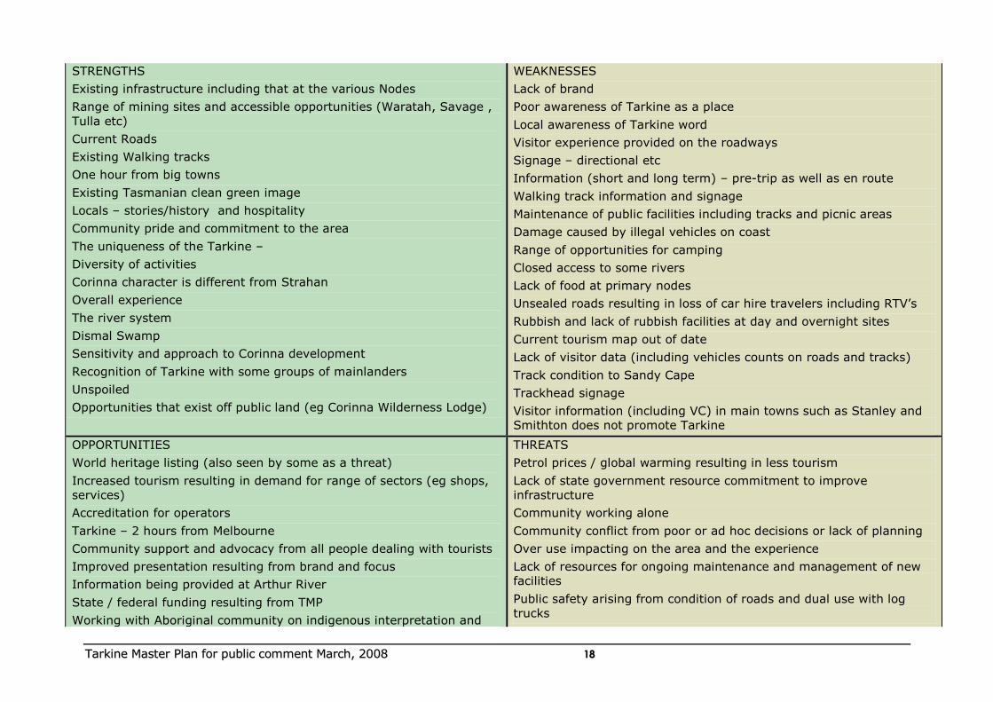
STRENGTHS
Existing infrastructure including that at the various Nodes
Range of mining sites and accessible opportunities (Waratah, Savage ,
Tulla etc)
Current Roads
Existing Walking tracks
One hour from big towns
Existing Tasmanian clean green image
Locals – stories/history and hospitality
Community pride and commitment to the area
The uniqueness of the Tarkine –
Diversity of activities
Corinna character is different from Strahan
Overall experience
The river system
Dismal Swamp
Sensitivity and approach to Corinna development
Recognition of Tarkine with some groups of mainlanders
Unspoiled
Opportunities that exist off public land (eg Corinna Wilderness Lodge)
WEAKNESSES
Lack of brand
Poor awareness of Tarkine as a place
Local awareness of Tarkine word
Visitor experience provided on the roadways
Signage – directional etc
Information (short and long term) – pre-trip as well as en route
Walking track information and signage
Maintenance of public facilities including tracks and picnic areas
Damage caused by illegal vehicles on coast
Range of opportunities for camping
Closed access to some rivers
Lack of food at primary nodes
Unsealed roads resulting in loss of car hire travelers including RTV‟s
Rubbish and lack of rubbish facilities at day and overnight sites
Current tourism map out of date
Lack of visitor data (including vehicles counts on roads and tracks)
Track condition to Sandy Cape
Trackhead signage
Visitor information (including VC) in main towns such as Stanley and
Smithton does not promote Tarkine
OPPORTUNITIES
World heritage listing (also seen by some as a threat)
Increased tourism resulting in demand for range of sectors (eg shops,
services)
Accreditation for operators
Tarkine – 2 hours from Melbourne
Community support and advocacy from all people dealing with tourists
Improved presentation resulting from brand and focus
Information being provided at Arthur River
State / federal funding resulting from TMP
Working with Aboriginal community on indigenous interpretation and
THREATS
Petrol prices / global warming resulting in less tourism
Lack of state government resource commitment to improve
infrastructure
Community working alone
Community conflict from poor or ad hoc decisions or lack of planning
Over use impacting on the area and the experience
Lack of resources for ongoing maintenance and management of new
facilities
Public safety arising from condition of roads and dual use with log
trucks

TTaarrkkiinnee MMaasstteerr PPllaann ffoorr ppuubblliicc ccoommmmeenntt MMaarrcchh,, 22000088 1199
experiences.
Leveraging off the Aboriginal Tourism Development Strategy
Petrol prices / global warming resulting in increased travel close to
home
Community education re Tarkine leading to improved protection
Fishing
Range of standards of camping
White water rafting
River based experiences including rafting 2 hours – 10 days
Mountain bike riding – Waratah rail and train tracks
Savage river interpretation being provided by mine
The Pipeline track as a through route
Industry working together leading to word of mouth promotion
Tarkine website
Tree top adventure / experience
4WD Induction as well as opportunities for tag along tours
Good Map / visitor Guide
Ability to leverage of other icon sites (Cradle / Strahan etc)
User pays approach to experiences
Partnerships (eg. Mining)
Mining heritage trail
Range of Short walks
Niche markets (fungi; birds etc orchids, ferns)
International students
White water
Mining heritage
Windsailing
Promoting the cultural heritage (eg Balfour, Temma, tramlines, old
maps)
Sealing of Western Explorer resulting in opportunities for day trips
Coastal walk (standing camp)
Base Camps for walkers and 4WD
Over-regulation on long term/traditional users
Increasing impacts from higher numbers arising from promotion (eg
motor bikes)
Inappropriate development
Protection of coastline (National Heritage)
Mining
Planning scheme and protected area plans inhibiting proposals
Lack of clear definition and provision of quality tourism experience
that people want
Fire / weed / pest etc
Litter / human waste / toilets
Disjointed tourism management
Increasing numbers at current peak periods
World Heritage listing
Bureaucratic approach to signage
TTaarrkkiinnee MMaasstteerr PPllaann ffoorr ppuubblliicc ccoommmmeenntt MMaarrcchh,, 22000088 2200
Fishing: trout, salmon and sea
Public toilets for visitors (eg. Temma)
Lighthouse at Marrawa
TTaarrkkiinnee MMaasstteerr PPllaann ffoorr ppuubblliicc ccoommmmeenntt MMaarrcchh,, 22000088 2211
5.2 Major Gaps
Taking into account the community views through the SWOT analysis and the project team‟s assessment, the major gaps that have been identified in the tourism offer to match the brand and target markets include:
Visitor experiences along corridors;
Remote and wild experiences;
Cultural tours;
Diversity in the accommodation mix;
Bushwalking opportunities (day and overnight);
Information (at all stages of the trip cycle);
Quality food and wine to complement the experiences on offer.
The following issues have been identified in relation to these gaps.
Corridors
The major road corridors do not currently present the optimal experience
to match the expectation of target markets. The Western Explorer has the potential to be one of the great self drives in Tasmania, and the South
Arthur Forest Drive provides some excellent stopping points and opportunities.
There is limited high quality infrastructure that provides the opportunity to
interact with the Tarkine on the corridors such as short walks, lookouts and interpretation. There is no consistent signage and interpretation and
limited toilets.
Remote and wild experiences
An important element of the Tarkine brand is about remoteness and wild
places. Visitors need to feel that they can connect with the wilderness somehow or it is likely they may be disappointed. Creating this
connection is a challenge given that the wilderness areas are limited and many are in areas which are not very accessible by vehicle.
There are a range of proposed strategies to connect visitors to the Tarkine
wilderness:
Rivers
Lookouts along key corridors
Interpretation
Fly in (Helicopter)
Remote accommodation
Cultural Tours
The Aboriginal cultural heritage values of the area are outstanding (Tas Parks and Wildlife pers. comm.) and have significant tourism potential.
There are currently no Aboriginal cultural tours operating in the region. Mt Cameron provides an Aboriginal visitor attraction, however is not promoted.
TTaarrkkiinnee MMaasstteerr PPllaann ffoorr ppuubblliicc ccoommmmeenntt MMaarrcchh,, 22000088 2222
There are also opportunities for cultural tours based on cattle droving, forestry and mining.
Accommodation
The current accommodation mix for the Tarkine is limited in diversity and
capacity. Arthur River, Waratah and Corinna provide accommodation ranging from basic hotel to 3 star comforts but at peak times access to accommodation of choice is difficult. Accommodation with
meals/hospitality is also limited at the present time.
There is a range of major accommodation nodes within easy drive
distance of the Tarkine including Smithton, Burnie, Cradle Mountain, Strahan, Stanley. These locations provide an alternative for visitors who cannot find preferred accommodation within the Tarkine. However this
requires the inconvenience of traveling to these locations then back to the Tarkine area.
There is also little or no remote comfort accommodation (such as eco-lodges or cabins in remote settings) in the Tarkine. There is a demand for this type of accommodation as part of nature based adventurous
experiences.
Bushwalking
The area currently provides some bushwalking experiences especially short walks close to nodes. There are some managed overnight walks and
limited short walks.
Whilst the concept of a multi day walk should be explored, a point of difference from other Tasmania walking experiences could be provided
through the development of an iconic multi activity adventure (walking, cycling, kayaking and possibly ATV).
There is increasing demand for short walks linked to tourism visitor attractions, corridors and nodes. More short walks are recommended with good signage and interpretation especially along major corridors such as
the Western Explorer and nodes such as Arthur River and Corinna where a range of track standards need to be provided.
Information
There is currently very poor information about Tarkine. Deficiencies include:
pre trip - information encouraging people to the area before they come to Tasmania or from the major access points.
Orientation- to advise people of the range of opportunities that exist and how to find their way to them or around them.
On site – to advise people of some of the main visitor experiences and
what they offer such as walking trailheads and visitor sites
Directional – to assist people in finding their way around the area and re-
assuring them they are on the right track
TTaarrkkiinnee MMaasstteerr PPllaann ffoorr ppuubblliicc ccoommmmeenntt MMaarrcchh,, 22000088 2233
Interpretation- to encourage appreciation of the values of the area as well as other key messages such as safety and minimum impact – in nodes, at
some trailheads, and on tracks and roads
Post trip – material that people may wish to take home to assist in
recollecting their experiences and showing to friends that may also visit
Food and wine
Whilst not offering an experience in its own right in the Tarkine, food and
wine are an important part of the Tasmanian experience and must be available.
Accommodation nodes need to be able to offer a range of eating opportunities suited to the market that are open and available when needed.
Individual accommodation establishment such as Corrinna and any new remote ventures will need to offer food and wine that complements the
experience on offer. This need not be lavish or formal, but should be a quality experience suited to the location and visit.
Where tour operators provide meals as part of a tour package, it is
expected that this will reflect the Tasmania brand of quality food and wine.
TTaarrkkiinnee MMaasstteerr PPllaann ffoorr ppuubblliicc ccoommmmeenntt MMaarrcchh,, 22000088 2244
6. TOURISM FRAMEWORK
6.1 The approach to be adopted
A planning framework has been developed to ensure that the tourism master plan addresses the full range of geographical and tourism
opportunities across the region. This framework also helps to classify, communicate and prioritise actions for implementation. The key elements of the master plan framework are:
Tarkine Entry points
Nodes
Corridors
Visitor Attractions
Visitor Sites
It is also important that the following are recognised as important in planning for tourism in the Tarkine.
Regional linkages and gateways
Landscapes
1. Tarkine Entry points – Locations at which the visitor firstly gets oriented to the experience they are seeking, and secondly, welcomed to the area. They need to provide a sense of the Tarkine as a place and appropriate
information to enable the visitor to determine a meaningful experience of the Tarkine. Tarkine Entry points may also overlap with other elements of
the tourism framework such as nodes.
The major Tarkine Entry points are Corrinna, Arthur River and Waratah. Minor Entry points are Meunna and Marrawa. Other locations (eg
Kanunnah Bridge, Temma) are important as orientation points for people going into specific parts of the Tarkine.
2. Nodes – places where people can access facilities such as accommodation. These are critical locations from which a range of experiences need to be accessible as a day trip or shorter to encourage
people to stay.
The following major Nodes occur within the Tarkine region.
Arthur River
Waratah
Corinna
The use of „taglines‟ to assist in defining the experience each node offers would ideally be developed as the brand progresses. These could be used
in marketing to assist in defining the range of experiences in each of the nodes that is different from the other nodes to assist the visitor to decide their ideal base for their visit.
Examples might be:
Arthur River – where the Tarkine meets the sea
Waratah – the historical centre
Corrinna – on the river
TTaarrkkiinnee MMaasstteerr PPllaann ffoorr ppuubblliicc ccoommmmeenntt MMaarrcchh,, 22000088 2255
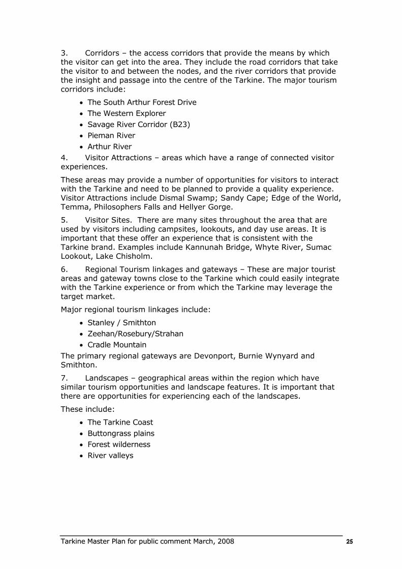
3. Corridors – the access corridors that provide the means by which the visitor can get into the area. They include the road corridors that take
the visitor to and between the nodes, and the river corridors that provide the insight and passage into the centre of the Tarkine. The major tourism
corridors include:
The South Arthur Forest Drive
The Western Explorer
Savage River Corridor (B23)
Pieman River
Arthur River
4. Visitor Attractions – areas which have a range of connected visitor experiences.
These areas may provide a number of opportunities for visitors to interact with the Tarkine and need to be planned to provide a quality experience.
Visitor Attractions include Dismal Swamp; Sandy Cape; Edge of the World, Temma, Philosophers Falls and Hellyer Gorge.
5. Visitor Sites. There are many sites throughout the area that are
used by visitors including campsites, lookouts, and day use areas. It is important that these offer an experience that is consistent with the
Tarkine brand. Examples include Kannunah Bridge, Whyte River, Sumac Lookout, Lake Chisholm.
6. Regional Tourism linkages and gateways – These are major tourist areas and gateway towns close to the Tarkine which could easily integrate with the Tarkine experience or from which the Tarkine may leverage the
target market.
Major regional tourism linkages include:
Stanley / Smithton
Zeehan/Rosebury/Strahan
Cradle Mountain
The primary regional gateways are Devonport, Burnie Wynyard and Smithton.
7. Landscapes – geographical areas within the region which have similar tourism opportunities and landscape features. It is important that there are opportunities for experiencing each of the landscapes.
These include:
The Tarkine Coast
Buttongrass plains
Forest wilderness
River valleys
TTaarrkkiinnee MMaasstteerr PPllaann ffoorr ppuubblliicc ccoommmmeenntt MMaarrcchh,, 22000088 2266
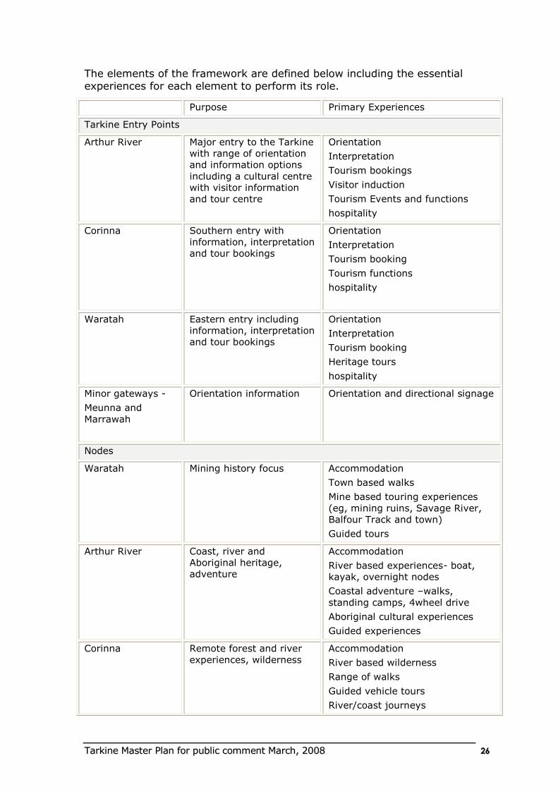
The elements of the framework are defined below including the essential experiences for each element to perform its role.
Purpose Primary Experiences
Tarkine Entry Points
Arthur River Major entry to the Tarkine
with range of orientation
and information options
including a cultural centre
with visitor information
and tour centre
Orientation
Interpretation
Tourism bookings
Visitor induction
Tourism Events and functions
hospitality
Corinna Southern entry with
information, interpretation
and tour bookings
Orientation
Interpretation
Tourism booking
Tourism functions
hospitality
Waratah Eastern entry including
information, interpretation
and tour bookings
Orientation
Interpretation
Tourism booking
Heritage tours
hospitality
Minor gateways -
Meunna and
Marrawah
Orientation information Orientation and directional signage
Nodes
Waratah Mining history focus Accommodation
Town based walks
Mine based touring experiences
(eg, mining ruins, Savage River,
Balfour Track and town)
Guided tours
Arthur River Coast, river and
Aboriginal heritage,
adventure
Accommodation
River based experiences- boat,
kayak, overnight nodes
Coastal adventure –walks,
standing camps, 4wheel drive
Aboriginal cultural experiences
Guided experiences
Corinna Remote forest and river
experiences, wilderness
Accommodation
River based wilderness
Range of walks
Guided vehicle tours
River/coast journeys
TTaarrkkiinnee MMaasstteerr PPllaann ffoorr ppuubblliicc ccoommmmeenntt MMaarrcchh,, 22000088 2277
Corridors
The South Arthur
Forest Drive
Easy drive through
Tarkine forest with a
range of visitor nodes
Short walks
Interpretation
Picnicking
The Western
Explorer
Signature drive through
Tarkine, where you
experience the diversity
of the Tarkine
Short walks
Interpretation
Lookouts
Savage River
Corridor (B23)
Part of the round the
Tarkine road tour
providing mining and
lookout experiences
Lookouts
Mining heritage
Waterfalls
Short walks
Pieman and Arthur
Rivers
Riverine tourism
experiences for large and
small groups
Boat tours
Canoeing
Fishing
Visitor Attractions
Dismal Swamp Eco tourism complex
which attracts a high
volume of visitors to
experience the Tarkine
Forest
Bushwalking
Bike riding
Forest Slide
Forest interpretation
Edge of the World Cultural centre
development aimed at
interpretation and
enhanced visitor
experience
Cultural interpretation
Tour centre
Hospitality
Lookout
Walking
Day use
Sandy Cape Remote overnight
accommodation on the
wild Tarkine Coast
ATV tours
Bushwalking
Fishing
Cultural tours
Hellyer Gorge Peaceful easy access day
use area
Bushwalking
Picnicking
Philosophers Falls Easy access day use area Bushwalking
Picnicking
Temma Rugged coastal
settlement and gateway
through to Sandy Cape
Coast shacks
Gateway to coastal wilderness
Regional Linkages
Smithton Provides a range of
tourism experiences
including accommodation
which can be accessed
en-route to the Tarkine
Accommodation
Food and Wine
Orientation
Stanley Provides a range of high Accommodation
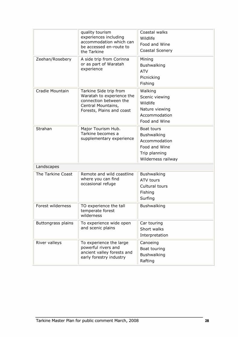
TTaarrkkiinnee MMaasstteerr PPllaann ffoorr ppuubblliicc ccoommmmeenntt MMaarrcchh,, 22000088 2288
quality tourism
experiences including
accommodation which can
be accessed en-route to
the Tarkine
Coastal walks
Wildlife
Food and Wine
Coastal Scenery
Zeehan/Rosebery A side trip from Corinna
or as part of Waratah
experience
Mining
Bushwalking
ATV
Picnicking
Fishing
Cradle Mountain Tarkine Side trip from
Waratah to experience the
connection between the
Central Mountains,
Forests, Plains and coast
Walking
Scenic viewing
Wildlife
Nature viewing
Accommodation
Food and Wine
Strahan Major Tourism Hub.
Tarkine becomes a
supplementary experience
Boat tours
Bushwalking
Accommodation
Food and Wine
Trip planning
Wilderness railway
Landscapes
The Tarkine Coast Remote and wild coastline
where you can find
occasional refuge
Bushwalking
ATV tours
Cultural tours
Fishing
Surfing
Forest wilderness TO experience the tall
temperate forest
wilderness
Bushwalking
Buttongrass plains
To experience wide open
and scenic plains
Car touring
Short walks
Interpretation
River valleys
To experience the large
powerful rivers and
ancient valley forests and
early forestry industry
Canoeing
Boat touring
Bushwalking
Rafting
TTaarrkkiinnee MMaasstteerr PPllaann ffoorr ppuubblliicc ccoommmmeenntt MMaarrcchh,, 22000088 2299
Recreational activities
These tourism areas interact with tourism and recreational activities and experiences which include:
Bushwalking
Canoeing
ATV
Fishing
Swimming
Surfing
Wildlife viewing
Self driving
Picnicking
Scenic viewing
Boat touring
Wilderness
Solitude
Cultural learning
Social connection
7. Tourism Development
7.1 The Tarkine Experiences
For the Tarkine brand positioning to be credible, the Tarkine must achieve excellence in:
Visitor infrastructure;
Interpretation and information;
Experience based or eco tourism accommodation;
Low impact development;
Tasmanian food and wine; and
A well managed destination.
The plan needs to provide a range of experiences that will ensure the ideal
visitor needs are met:
Appropriate accommodation to encourage them to stay a few days with different things to see and do;
Experiences that enable them to interact with the local community and learn something about the people and their place;
Opportunities for immersive experiences that offer long term learning;
Adventure and potential to be active.
TTaarrkkiinnee MMaasstteerr PPllaann ffoorr ppuubblliicc ccoommmmeenntt MMaarrcchh,, 22000088 3300
It needs to provide an opportunity for visitors to experience the Flagship Attributes of:
Globally significant temperate rainforest;
Aboriginal and European heritage;
Dramatic diverse places (wild rivers, rugged coastline, mountains, expansive views);
Accessible wilderness;
Rare and threatened species.
It needs to offer ways by which visitors can engage in powerful
connections with wild places
The following need to be developed as integral to the Tarkine
experience
Additional accommodation that is different to the existing supply and
offers unique interaction with the attributes of the Tarkine;
Effective visitor information to enable the visitor to plan their trip to meet their expectations;
Interpretation that enables people to appreciate and understand the attributes of the Tarkine including opportunities for lookouts and for
face to face interpretation;
Opportunities for interacting with the local community including indigenous and non indigenous people in their country;
Guided and unguided experiences that offer a range of levels and styles of adventure and ways to interact with the more remote parts
of the Tarkine;
A means to presenting and creating an understanding and appreciation of the extensive aboriginal history associated with the
area;
Tasmanian food and wine as part of the experience.
The following sections identify an approach to delivering these needs across the Tarkine which will need to be staged over time.
7.2. Tarkine Entry Points
The entry points are critical locations to ensure that the visitor gets the information they require once they have arrived in the area to determine
where they wish to go and the experiences they wish to have. Major entry points need to have the capacity for face to face as well as static
information.
Below are proposed information approaches for different entry points and their function in terms of way-finding, interpretation and promotion. The
design of information, infrastructure and experiences will all be consistent with the Tarkine brand.
TTaarrkkiinnee MMaasstteerr PPllaann ffoorr ppuubblliicc ccoommmmeenntt MMaarrcchh,, 22000088 3311
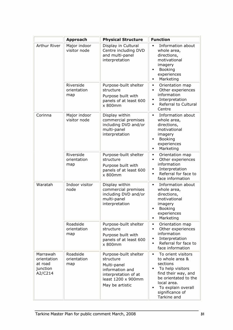
Approach Physical Structure Function
Arthur River Major indoor
visitor node
Display in Cultural
Centre including DVD
and multi-panel
interpretation
Information about
whole area,
directions,
motivational
imagery
Booking
experiences
Marketing
Riverside
orientation
map
Purpose-built shelter
structure
Purpose built with
panels of at least 600
x 800mm
Orientation map
Other experiences
information
Interpretation
Referral to Cultural
Centre
Corinna Major indoor
visitor node
Display within
commercial premises
including DVD and/or
multi-panel
interpretation
Information about
whole area,
directions,
motivational
imagery
Booking
experiences
Marketing
Riverside
orientation
map
Purpose-built shelter
structure
Purpose built with
panels of at least 600
x 800mm
Orientation map
Other experiences
information
Interpretation
Referral for face to
face information
Waratah Indoor visitor
node
Display within
commercial premises
including DVD and/or
multi-panel
interpretation
Information about
whole area,
directions,
motivational
imagery
Booking
experiences
Marketing
Roadside
orientation
map
Purpose-built shelter
structure
Purpose built with
panels of at least 600
x 800mm
Orientation map
Other experiences
information
Interpretation
Referral for face to
face information
Marrawah
orientation
at road
junction
A2/C214
Roadside
orientation
map
Purpose-built shelter
structure
Multi-panel
information and
interpretation of at
least 1200 x 900mm
May be artistic
To orient visitors
to whole area &
sections
To help visitors
find their way, and
be orientated to the
local area.
To explain overall
significance of
Tarkine and
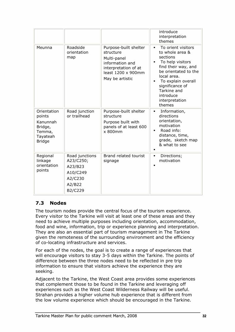
TTaarrkkiinnee MMaasstteerr PPllaann ffoorr ppuubblliicc ccoommmmeenntt MMaarrcchh,, 22000088 3322
introduce
interpretation
themes
Meunna Roadside
orientation
map
Purpose-built shelter
structure
Multi-panel
information and
interpretation of at
least 1200 x 900mm
May be artistic
To orient visitors
to whole area &
sections
To help visitors
find their way, and
be orientated to the
local area.
To explain overall
significance of
Tarkine and
introduce
interpretation
themes
Orientation
points
Kanunnah
Bridge,
Temma,
Tayateah
Bridge
Road junction
or trailhead
Purpose-built shelter
structure
Purpose built with
panels of at least 600
x 800mm
Information,
directions
orientation,
motivation
Road info:
distance, time,
grade, sketch map
& what to see
Regional
linkage
orientation
points
Road junctions
A23/C250;
A23/B23
A10/C249
A2/C230
A2/B22
B2/C229
Brand related tourist
signage
Directions;
motivation
7.3 Nodes
The tourism nodes provide the central focus of the tourism experience. Every visitor to the Tarkine will visit at least one of these areas and they
need to achieve multiple purposes including orientation, accommodation, food and wine, information, trip or experience planning and interpretation.
They are also an essential part of tourism management in The Tarkine given the remoteness of the surrounding environment and the efficiency of co-locating infrastructure and services.
For each of the nodes, the goal is to create a range of experiences that will encourage visitors to stay 3-5 days within the Tarkine. The points of
difference between the three nodes need to be reflected in pre trip information to ensure that visitors achieve the experience they are seeking.
Adjacent to the Tarkine, the West Coast area provides some experiences that complement those to be found in the Tarkine and leveraging off
experiences such as the West Coast Wilderness Railway will be useful. Strahan provides a higher volume hub experience that is different from the low volume experience which should be encouraged in the Tarkine.
TTaarrkkiinnee MMaasstteerr PPllaann ffoorr ppuubblliicc ccoommmmeenntt MMaarrcchh,, 22000088 3333
Arthur River
Aim: To provide a central focus and link between the diverse landscapes
of the coast and the wild and remote parts of the Tarkine
Recommendations
AR1 Explore low volume, high yield experiential accommodation
alternatives focused on the character and opportunities of the Tarkine (eg “coastal eco-shacks” and remote Arthur River camp)
AR2 Investigate feasibility and partnership with Aboriginal community to establish Cultural Interpretive Centre at Edge of the World incorporating:
Interpretation and education
Business centre for guided tours
Business enterprise opportunities and support (eg micro businesses
such as guiding, retail, art/crafts)
Café offering ocean based experiences (including sunset and sunrise)
Other business opportunities such as accommodation and tour
booking centre, permit issue, retail etc.)
Aboriginal education program
AR3 Encourage the development and promotion of additional river based opportunities including
Kayak hire and guided trips
Overnight kayak trips with serviced overnight camp
AR4 Retain the low volume capacity of river cruises with incentive for
investment in lunch sites through lease arrangements; and encouragement of showcasing the Tasmanian food and wine on lunch and evening cruises.
AR5 Investigate the potential to create a mountain bike track along the old Balfour rail track with potential for remote overnight accommodation
option.
AR6 Initiate a site master plan for Sandy Cape that includes consideration of
appropriate levels of use and facilities
management of aboriginal sites
management and rehabilitation of tracks
spreading peak use through the existing permit system
designation of camp sites
identification of sites for lease for commercial camps
Waratah
Aim: To provide an easy access point for exploring the historic past of the Tarkine as well as the wild and mysterious areas to the south.
TTaarrkkiinnee MMaasstteerr PPllaann ffoorr ppuubblliicc ccoommmmeenntt MMaarrcchh,, 22000088 3344
Recommendations
W1 Develop a class one walk and lookout over the Falls.
W2 Investigate the establishment of a heritage trail within the town.
W3 Seek interest in a commercial opportunity that provides guided tours
of the mining history from this node including Savage River mine tours.
W4 Initiate a site master plan to upgrade the visitor facilities at Hellyer Gorge to provide an attractive day use site with short walks.
Corinna
Aim: To provide accommodation in a wilderness setting with opportunities for diverse interaction with the wild and remote landscapes, rivers, forests and heritage of the Tarkine
Recommendations
C1 Continue to provide wilderness accommodation experience at Corinna
with planned investment in providing appropriate hospitality.
C2 Investigate appropriate siting and management of a campground in the Corinna area.
C3 Plan a suite of walks that range from short class one to class three for day walks.
C4 Establish walk track along the Pieman River from Corinna to the Savage River with track and lookout to falls on the Savage River.
C5 Investigate the potential for a three day walk from the head of the
Pieman and up the coast with opportunities for overnight facilities and commercial guiding.
C6 Consider the establishment of remote (potentially eco-shack) accommodation on the coast that offers an overnight boat-based experience from Corinna (kayak or drop off).
C7 Investigate the development of an iconic guided multi day experience between Arthur River and Corinna that includes cycling, walking and
kayaking between eco camps and exploring the range of natural and cultural values of the area.
7.4 Corridors
Current road corridors accessing the Tarkine include:
Western Explorer
The South Arthur Forest Drive
Savage River Corridor (B23)
Tullah to Corinna along the C250
These existing four corridors through the Tarkine provide glimpses of the wild interior and ways of experiencing the remoteness.
There is also a proposal by Forestry Tasmania to develop a road that links Meunna and the South Arthur Forest Drive to Arthur River. This would
provide access through a remote sector of the Tarkine.
TTaarrkkiinnee MMaasstteerr PPllaann ffoorr ppuubblliicc ccoommmmeenntt MMaarrcchh,, 22000088 3355
The river corridors are a significant part of the overall experience that
enables interaction with the remote inland of the Tarkine
The Pieman River
The Arthur River
As well as a range of tributaries and smaller rivers
The experiences associated with the rivers have been discussed under the
Arthur River and Corinna nodes.
The primary road corridors that should continue to be developed and
promoted to create unique experiences are:
Western Explorer
The South Arthur Forest Drive
Savage River Corridor (B23)
The Western Explorer is considered the ideal road corridor that will
provide the visitor with the opportunity to explore and interact with the range of landscapes of the Tarkine (forest, open plains and coastal) through linking key nodes and visitor opportunities. Sealing the road as a
“parkway” based on a narrow seal of the existing alignment to retain a minor road feel through the forest, will encourage greater use by visitors
including those with hire cars or averse to unsealed roads. The identification and development of a suite of stopping points should be
planned as part of the road upgrade to create opportunities for picnicking, walking and interaction/interpretation with the Tarkine.
The South Arthur Forest Drive already offers a route through some
spectacular parts of the Tarkine with stopping points offering interaction with the forest. This route, combined with the Western Explorer, enables a
through journey for visitors using an unsealed road and with excellent walking, picnicking and camping opportunities.
The Savage River corridor is important to encourage people to undertake
a circular journey between the Tarkine nodes as well as providing a linking route for visitors to the nearby Cradle Mountain and Strahan hubs.
The development of guided access along the Flynn Hart Pipeline track would be a positive long term outcome for the Tarkine experience should this be feasible. It offers opportunities for additional brand related
experiences without compromising the remote attributes of the overall Tarkine.
If the three primary corridors (The South Arthur Forest Drive, Western Explorer and Savage River Corridor) are developed as quality tourism visitor experiences with appropriate stopping points and information, they
will provide a suitable mix of access to the area consistent with the vision and brand without compromising the remote character and remote and
wild attributes of the Tarkine. The Flynn Hart Pipeline Track would be a valuable addition to this range of access once the mine has ceased operations.
The secondary access link from Tullah to Corinna along the C250 needs to be recognised as an important link with the experiences in the Strahan
TTaarrkkiinnee MMaasstteerr PPllaann ffoorr ppuubblliicc ccoommmmeenntt MMaarrcchh,, 22000088 3366
area, some of which are suited to similar market groups and will form part of the broader experience.
South Arthur Forest Drive
Aim: To provide a unique drive experience with a number of experiences suited to the market that will encourage appreciation of the values of the Tarkine.
Recommendations
SF1 Upgrade the visitor facilities along the South Arthur Forest Drive
consistent with the Tarkine brand.
SF2 Re-design Kanunnah Bridge visitor node to include:
Orientation and interpretive information about the drive and the
Tarkine values and opportunities;
pleasant picnic/day use facilities;
lookout experience over river;
short walk to river;
safe kayak access point.
SF3 Encourage visitors to Sumac Lookout through improved parking and signage and brand related interpretation of the vista
SF4 Julius River Forest Reserve ---upgrade the walking tracks to class two standard and provide information and interpretation
SF5 Lake Chisholm Forest Reserve – extend the importance of this site for
longer stay through:
extending the walk to create a circuit
providing interpretation and orientation information
installing minor picnic area
SF6 Investigate a walk from Dempster Lookout to the falls at Wes Beckett
Forest reserve returning to the road at Rapid River
SF7 Create a gateway/orientation experience at Tayatea Bridge including
walk down to the river
Western Explorer
Aim: To provide the primary access route along the edge of the Tarkine and traversing many of the environments that make up the Tarkine
experience.
Recommendations
WE1 Seek funding for the sealing of the Western Explorer as a “parkway”
designed for slow travel to encourage access by the target markets.
WE2 Upgrade the visitor facilities along the Western Explorer consistent
with the Tarkine Brand.
WE3 As part of road upgrade program, establish a number of additional visitor sites to provide a stopping point approximately every twenty
minutes to encourage enjoyment of the Tarkine experience and observation of the range of values. These could include:
TTaarrkkiinnee MMaasstteerr PPllaann ffoorr ppuubblliicc ccoommmmeenntt MMaarrcchh,, 22000088 3377
Lookouts at strategic locations (eg. Frankland River)
Short walks
Day use and picnic facilities at Donaldson River or other suitable location.
WE4 Identify and manage the Longback track as an iconic short walk including:
Upgrading of trailhead to include orientation and directional signage
and parking;
Maintenance of existing track to class two standard;
Interpretation of Tarkine vista through lookout point at The end of the walk.
W5. Develop the Mount Balfour track as a multiple-use track with
interpretation about the mining history
Savage River Rd
Recommendations
SR1 Initiate a site master plan for the Philosophers Falls area to address:
Improvements to the trailhead for Philosopher Falls to provide a high quality day use experience;
Development of a low key camping area potentially at the turnoff to Philosopher Falls.
SR2 Develop a pullover carpark and interpretation lookout including the
mine at the Whyte river area near Savage River
Flynn Hart Pipeline track
Recommendations
FP1 Investigate the potential for offering guided experiences along the
Flynn Hart Pipeline track including the development of visitor experiences at Tarkine Falls and the proposed Flynn Hart Bridge.
7.5 Visitor Attractions
As sites that offer a unique visitor experience or range of experiences,
visitor attractions need detailed local planning to ensure that development is consistent with the brand.
The following comments identify the approach required:
Dismal Swamp Planning undertaken as necessary by Forestry; promotion as
part of the Tarkine experience offer required
Edge of the World initiate a detailed site master plan as part of business planning
for Cultural Centre
Sandy Cape Site master plan proposed as part of Arthur River node
recommendations
Hellyer Gorge Site Master plan proposed as part of Waratah node
recommendations
Temma Site master plan required to improve visitor experience and
TTaarrkkiinnee MMaasstteerr PPllaann ffoorr ppuubblliicc ccoommmmeenntt MMaarrcchh,, 22000088 3388
identify any potential for „eco-shack‟ accommodation and
minimise conflict between residents and visitors
Philosophers Falls Site master plan proposed as part of Savage River road
corridor recommendations
7.6 Visitor Sites
Whilst the visitor attractions provide planning for some of the key visitor experiences, there are other current and potential opportunities that have
been highlighted on corridors. Still others exist in the broader area. Some new opportunities have also been identified (eg overnight nodes) that could be located in any of a number of places in the dependent on detailed
planning and the business potential identified.
All visitor sites need to be maintained and/or developed consistent with
the brand. Recommended levels of service are identified below.
Camping
Three primary standards of camping areas are proposed within the Tarkine as follows:
Class one camping (remote):
o remote and/or natural setting with limited facilities;
o basic facilities including toilets, picnic tables, some delineated
car parking;
o expectation of low-moderate volume numbers;
o may be one group camp site or separation of small travel party and group camping areas.
Class two camping (easy access):
o formalised and managed campground setting with toilets, BBQs, management services- fee charged for camping;
o expectation of moderate to high volume numbers;
o may be a number of group camps.
Class three camping (commercial):
o commercial facility (may be associated with other accommodation) – managed facility with high standard facilities;
o may have power; expectation of moderate volume numbers; large group camps possible.
There may also be:
(i) Campsites that are special permit access only with limited access, limited numbers, limited facilities (toilets for environmental management
purposes only) – fee for permit; very small numbers (which may be small group).
(ii) Exclusive use sites – managed as component of business – unique setting; varying standards and services; varying fees; very small numbers or one group only.
TTaarrkkiinnee MMaasstteerr PPllaann ffoorr ppuubblliicc ccoommmmeenntt MMaarrcchh,, 22000088 3399
Recommendations
R1 Undertake detailed assessment of the current and potential
opportunities for camping in the Tarkine consistent with identified standards.
Day Use Facilities
Three standards of day use facilities are proposed based on different types
of recreation settings:
Class One Day use (remote) – day use in remote natural areas with
simple facilities consistent with setting;
Class Two Day use (comfort) – day use in higher use area (eg along road corridors) with simple day use facilities suited to environmental
setting and volume of use;
Class Three Day use (developed) – day use facilities in high use area
(eg nodes) with high standard of facilities, information and interpretation
Recommendations
R2 Undertake detailed assessment of the current and potential opportunities for day use in the Tarkine consistent with identified
standards.
7.7 Regional Linkages
The regional linkages are areas from which it is likely some visitors to the Tarkine will be sourced by chance or by good planning. Some of the tourism opportunities at Strahan, (the Wilderness railway, for example)
would be ideally suited to the target market.
It is important to ensure that appropriate pre-trip information is available
to encourage visitors to take in the Tarkine as well as regional linkages. Encouraging the Tarkine as the destination from which people visit regional linkages should be the goal.
In addition to pre-trip information, effective on site orientation information and directional signage at key points to direct people to the Tarkine from
linkages needs to be ensured. This includes face to face information provided at Visitor Centres. Further advice on information and signage is provided later in this plan.
7.8 Landscapes
It is important that visitors see, appreciate and ideally understand the
landscapes of the Tarkine. This is to be achieved through the visitor experiences that are offered and through appropriate information and
signage.
By promotion of the major experiences including travelling along the road corridors, taking the walking opportunities, and experiencing the rivers,
visitors will gain an appreciation of the significant landscapes of the area.
TTaarrkkiinnee MMaasstteerr PPllaann ffoorr ppuubblliicc ccoommmmeenntt MMaarrcchh,, 22000088 4400
8. RECREATION MANAGEMENT STRATEGIES
8.1 Bushwalking
Bushwalking is one of the ideal ways in which to experience the key attributes of the Tarkine and it is likely that the majority of visitors would
undertake at least one walk in the area. To ensure the range of visitors expectations can be met, as well as those of the local community, and that adequate experiences are on offer at each node, it is recommended that a
full range of walking tracks be available.
Australian Standard 2156.1 (AS 2156.1) Walking Tracks Part 1:
Classification and signage (Standards Australia, 2001) provides a hierarchy of track standards that allows for a wide variety of terrain, a spectrum of different experiences for track walkers and different levels of construction.
The track classification provides a consistent way of describing construction standards, safety intervention, signage, maintenance levels, and other
parameters. AS 2156.1 (summarised in Table 8.1) below is commonly used by land managers across Australia in the planning, design and construction of walking tracks.
Table 8.1: Walking Track Standards – summary (AS2156.1)7
1: Path - easy – all access, hard surface, no steps, wheelchair
accessible; high safety; suitable all ages/difficulty.
2: Walk – easy well surfaced track; some steps; few difficulties; high
safety level; suited to all ages but care with children.
3: Track – moderate – distinct track with steep and rough sections. Steps and some difficulties; moderate safety; suited to people who walk
occasionally.
4: Track-hard – distinct track with long steep and rough sections; many
steps and stairs and/or frequent difficulties; low to moderate safety level; suited to regular walkers.
5: Route – hard – rough unformed track; steep with frequent
difficulties; minimal signage and low safety level; experienced bushwalkers only.
6: Route – unmarked and unmodified route with frequent obstacles; dependence on navigation.
By its nature the standard details complex information that is not
necessarily suited to describing tracks for the walker. A track may also
7 Source: AS2156.1 General classification for walking tracks
TTaarrkkiinnee MMaasstteerr PPllaann ffoorr ppuubblliicc ccoommmmeenntt MMaarrcchh,, 22000088 4411
include a range of track standards over the journey, and this is difficult to convey to the walker.
Generally, walkers look for simple and straightforward information to enable them to make informed decisions. The information needs to be easily
recognisable, clear, concise, and consistent. The following information needs to be communicated to the users:
difficulty
walking conditions
level of safety intervention.
There are currently some walking tracks in the Tarkine with varying standards and levels of maintenance. Overnight guided walks are offered by a commercial operator, and bushwalkers are known to use some of the
more remote parts of the wilderness.
The following is proposed as a starting point for the network of walking
tracks. Detailed planning will be required to ensure the network is effectively implemented.
Location Proposed Class of walk
Arthur River
Review short walks around and within Arthur river
especially linking with Lands End
Class 1-3
Arthur River bridge to Big Bend (2-3 km loop) class 2
Arthur River to Marrawah via the lighthouse class 3-4
Arthur River to Temma class 2-3
Arthur River - Big Dune loop Class 2-3
MGowans Fall (Glow Worm) Class 1
Arthur river across to Frankland river back to coast (via boat) which links in with possible overnight camps
Class 3-4
Review possible coast walk from Green Point to Mt Cameron coastal walk
Class 4
Balfour Track – Develop into a heritage track possibly for multiple-use.
Class 3-4
Formalise a walkd from Sandy Cape Walk from Temma Class 3-4
SE Forest Drive
Maintain existing short walks Class 2 -4
Develop a longer half day walk in the area which links existing sites
Class 3
Western Explorer
TTaarrkkiinnee MMaasstteerr PPllaann ffoorr ppuubblliicc ccoommmmeenntt MMaarrcchh,, 22000088 4422
Review future development of an overnight walk on Norfolk Range which links with the Donaldson River
Class 4-5
Identify a number of short walks along the Western Explorer linking to day use areas and lookouts.
Class 1 -3
Pieman
Maintain Pieman coast walk as a coastal wilderness
walk. Review development of standing camps.
Class 3-4
Review use of the proposed Flyn Hart Pipe Span Walk
for controlled and supervised access.
Class 3
Maintain short walks around Corinna Class 2-3
Maintain/upgrade the Mt Donaldson Walk Class 3
Develop a short walk at Reece Dam Class 3
Warratah
Develop the walk to Mt Bishcoff as an interpretative track
Class 3
Upgrade the Philosophers Falls walk to link in with proposed carpark.
Class 2
Review the tracks in the Meredith Range area to provide for walking and four wheel drive without conflict between the uses.
Class 3-5
Develop/upgrade the walk to Mt Cleveland from Luenna
Class 3
Hellyer Gorge
Maintain the Range of short walks at Hellyer Gorge Class 1-3
Meunna
Develop a range of short walks Class 2-3
Keep walks in the Tarkine Falls area as routes at this
stage. Possible development of walk to Tarkine falls if access to the area is provided.
Class 2-3
Recommendations
a. R3 Develop a comprehensive walking track strategy that determines priorities for upgrading and maintenance of walking tracks in the
Tarkine
8.2 Canoeing
TTaarrkkiinnee MMaasstteerr PPllaann ffoorr ppuubblliicc ccoommmmeenntt MMaarrcchh,, 22000088 4433
Canoeing and rafting offer the ideal way in which to experience the Tarkine from its river corridors. The development of experiences that enable visitors
to achieve this including overnights stays should be encouraged.
Recommendations
R4 Identify suitable sites that can be offered as opportunities for the establishment of an overnight accommodation experience on the Arthur River as part of a guided canoeing experience.
R5 Establish camp site for independent canoeists between Kannunah Bridge and Arthur River.
R6 Identify suitable site as opportunity for overnight “satellite accommodation” from Corinna for canoeists on the Pieman River.
R7 Provide safe canoe launching areas at Arthur River, Corinna, the bridge
at Kannunah and overnight nodes.
8.3 Cycling
Some opportunities have been identified to be investigated for mountain bike riding. These include:
Balfour Track
Meredith Ranges
Flynn Hart Pipe Span route
There is currently no Australian Standard dealing with bicycle tracks. Two other systems are in use
The International Mountain Bicycling Association‟s (IMBA) Trail Difficulty Rating System (using similar symbols to those used at downhill ski resorts) and
A numerical grading system grading trails 1 (easiest) through 5 (most difficult)
The IMBA Trail Difficulty Rating System is outlined in Appendix 2.
Recommendations
R8 Develop a comprehensive cycle track strategy that determines priorities
for upgrading and maintenance of tracks in the Tarkine
8.4 Four wheel driving
Some areas of the Tarkine are popular for four wheel driving and trail bike riding. Some areas are subject to permits and requirements under plans of
management.
As a viable and good opportunity to experience the Tarkine, ongoing sustainable opportunities need to be available for these activities for the
local community, traditional users and visitors to the area.
Recommendations
R9 As part of the management of the Arthur Pieman Conservation Area, continue the process of review of tracks and 4wd coastal access to ensure sustainable use.
TTaarrkkiinnee MMaasstteerr PPllaann ffoorr ppuubblliicc ccoommmmeenntt MMaarrcchh,, 22000088 4444
R10 Identify suitable tracks that offer 4wd opportunities in the Meredith range area and that are not in conflict with bushwalking tracks.
R11 Encourage commercial opportunities for guided tagalong trail/quad bike tours to Sandy Cape including interpretation of Aboriginal sites and sites for
standing camps or similar.
R12 Regulate driving in sensitive areas with a permit based system and possible induction training for new visitors to the area.
8.5 Other recreational activities
The other main activities that occur in the area are fishing and surfing.
These are activities which are not carried out in any formal manner and are popular with the local community and existing visitors. No special provision
is recommended for these activities.
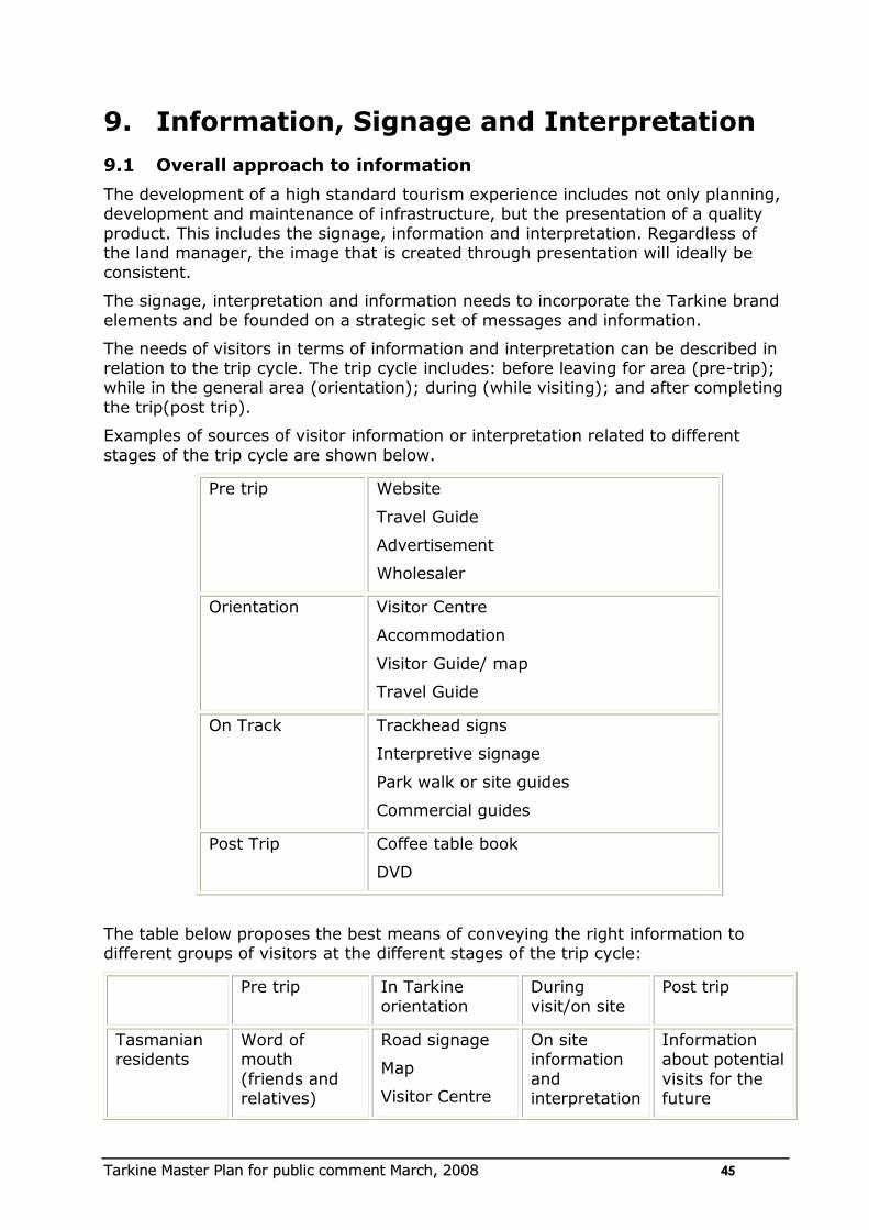
TTaarrkkiinnee MMaasstteerr PPllaann ffoorr ppuubblliicc ccoommmmeenntt MMaarrcchh,, 22000088 4455
9. Information, Signage and Interpretation
9.1 Overall approach to information
The development of a high standard tourism experience includes not only planning, development and maintenance of infrastructure, but the presentation of a quality
product. This includes the signage, information and interpretation. Regardless of the land manager, the image that is created through presentation will ideally be consistent.
The signage, interpretation and information needs to incorporate the Tarkine brand elements and be founded on a strategic set of messages and information.
The needs of visitors in terms of information and interpretation can be described in relation to the trip cycle. The trip cycle includes: before leaving for area (pre-trip); while in the general area (orientation); during (while visiting); and after completing
the trip(post trip).
Examples of sources of visitor information or interpretation related to different
stages of the trip cycle are shown below.
Pre trip Website
Travel Guide
Advertisement
Wholesaler
Orientation Visitor Centre
Accommodation
Visitor Guide/ map
Travel Guide
On Track Trackhead signs
Interpretive signage
Park walk or site guides
Commercial guides
Post Trip Coffee table book
DVD
The table below proposes the best means of conveying the right information to different groups of visitors at the different stages of the trip cycle:
Pre trip In Tarkine orientation
During visit/on site
Post trip
Tasmanian residents
Word of mouth
(friends and relatives)
Road signage
Map
Visitor Centre
On site information
and interpretation
Information about potential
visits for the future
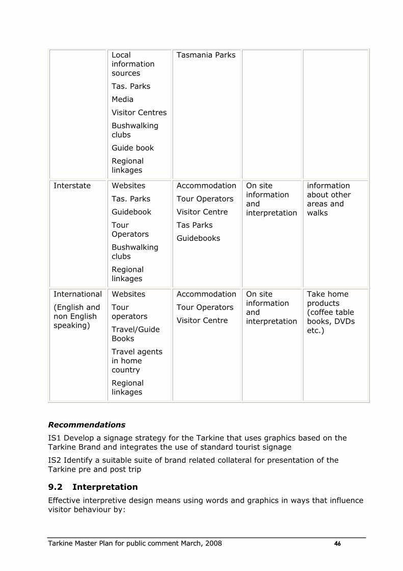
TTaarrkkiinnee MMaasstteerr PPllaann ffoorr ppuubblliicc ccoommmmeenntt MMaarrcchh,, 22000088 4466
Local information
sources
Tas. Parks
Media
Visitor Centres
Bushwalking
clubs
Guide book
Regional
linkages
Tasmania Parks
Interstate Websites
Tas. Parks
Guidebook
Tour Operators
Bushwalking
clubs
Regional
linkages
Accommodation
Tour Operators
Visitor Centre
Tas Parks
Guidebooks
On site
information and
interpretation
information
about other areas and
walks
International
(English and non English speaking)
Websites
Tour operators
Travel/Guide
Books
Travel agents
in home country
Regional linkages
Accommodation
Tour Operators
Visitor Centre
On site
information and interpretation
Take home
products (coffee table books, DVDs
etc.)
Recommendations
IS1 Develop a signage strategy for the Tarkine that uses graphics based on the
Tarkine Brand and integrates the use of standard tourist signage
IS2 Identify a suitable suite of brand related collateral for presentation of the
Tarkine pre and post trip
9.2 Interpretation
Effective interpretive design means using words and graphics in ways that influence
visitor behaviour by:
TTaarrkkiinnee MMaasstteerr PPllaann ffoorr ppuubblliicc ccoommmmeenntt MMaarrcchh,, 22000088 4477
Encouraging and enticing visitors to follow paths or stop at exhibits;
Informing them about what they are seeing (answering their questions), while
encouraging genuine opportunities for personal discovery and delight; and
Provoking them to ask themselves important questions such as „How does this
relate to me?‟ How do I feel about this now?‟ or „What could I do to change this?‟ without encouraging guilt or sadness.
Interpretation is really important in delivering the messages of the Tarkine and its
major landscapes and is not at all well done at the present time.
The amount of interpretation material and its content will be influenced by:
the interpretation messages to be conveyed
a strategic approach to delivering these messages across the Tarkine;
the standard and classification of the walking tracks (with more interpretation
of classes 1-2 that 5-6);
the special interest value of each site;
creative ideas for interpretation.
The following principles should be applied when planning interpretation and trackhead signage:
Interpretation panels should have approximately one-third text, one-third graphics or pictures and one-third as background space.
Where possible use a variety of graphics such as maps and illustrations to add some visual complexity to attract attention.
Interpretation signs which vary in shape and form from the traditional rectangular sign should be encouraged (See examples following).
The design of interpretation signs should include suitable background colours
which blend into the natural environment.
Interpretation signage should be multi-layered (using text, pictures, graphics
and interactive elements) to suit a range of visitor learning styles including visual and literal.
Recommendations
IS3 Develop an interpretation plan for the Tarkine that focuses on the use of primary themes related to the flagship attributes of:
Globally significant temperate rainforest
Aboriginal and European heritage
Dramatic diverse places (wild rivers, rugged coastline, mountains, expansive
views)
Wilderness
Rare and threatened species
IS4 Develop appropriate interpretation such as an audio guide to encourage appreciation of the various aspects of the Tarkine including the stories, the music
and the art of the past.
TTaarrkkiinnee MMaasstteerr PPllaann ffoorr ppuubblliicc ccoommmmeenntt MMaarrcchh,, 22000088 4488
10. Tourism management
10.1 Land tenure
The Tourism Master Plan has set out a range of opportunities that could be provided and would create a unique tourism cluster for the north west
of Tasmania.
Some of the opportunities could occur on a number of different land tenures and others are proposed for particular locations.
Clearly the cooperation and engagement of land management agencies and councils is essential to enable consideration being given to such
developments.
Cooperative ventures such as joint planning schemes between councils and streamlined development application processes need to be explored
and encouraged.
10.2 Capacity building
Capacity building is essential to the delivery of high standard tourism experience including in hospitality and in Aboriginal enterprise
development. If a professional and integrated tourism experience is to be provided, all businesses need to offer the highest of standard of services.
The Tasmanian Aboriginal Tourism Strategy identified the following needs
for aboriginal tourism:
training, business planning and mentoring programs;
an enterprise centre to serve as a focus for skill development;
harnessing the skill base through establishing an enterprise and/or workshop centre;
funding and business support.
Indigenous businesses elsewhere in Australia have benefited significantly
from the Stepping Stones program and from Respect our Culture accreditation. These would be an excellent start point to work towards the
outcomes proposed under Arthur River visitor attraction.
10.3 Environmental and cultural management
The highest standards of environmental and cultural management need to
be applied to the Tarkine consistent with the brand and expectation of a high quality destination and settings. Given the profile of the Tarkine and
the brand, it can be expected that commercial viability of tourism will be directly linked to environmental and cultural sustainability in the Tarkine.
This can be achieved through a number of options such as the
development of environmental management plans for businesses which includes performance assessment or requirements for accreditation such
as Green Globe or other environmental certification.
10.4 Leases, Licences and Permits
Accommodation, food, transport and tour services including guiding are the usual areas of private sector involvement in tourism, but the private
TTaarrkkiinnee MMaasstteerr PPllaann ffoorr ppuubblliicc ccoommmmeenntt MMaarrcchh,, 22000088 4499
sector can also contribute increasingly in areas such as education and interpretation. Private sector investment will occur where there is an
opportunity for adequate financial return.
Leases, licenses and permits need to be structured in a way that is
attractive to businesses while not conflicting with the management aims for the site in which the proposal is planned. Leases, licenses and permits should:
Reflect the nature of the investment and the service provided;
Allow for value to be retained in the business while at the same time
acknowledging the fact that the business is operating in a unique environment;
Be long enough to allow operators to realise the full mortgage value
of their in fixed assets;
Provide adequate return on investment ;
Reflect the value of a business, including the value of 'good will', to a potential buyer;
Encourage enterprises that can afford quality visitor service and
protection as core commitments whilst creating a profitable business for the investor;
Set out all expectations in terms of exactly what is permitted, what services are to be provided, standards, development approval
processes, environmental requirements, services and so on;
Minimise the need for day-to-day approvals and oversight by land managers by incorporating clearly set out agreed standards of
maintenance and operation;
Have a lease period suited to the scale of investment, with options for
renewal based on performance – with the longest leases linked to high levels of commercial investment and high standards of environmental performance.
10.5 Accreditation
Accreditation programs can assist commercial tour operators in meeting
their responsibilities within protected areas (eg Arthur Pieman), by ensuring visitors obtain a quality experience through the provision of
quality services, facilities and interpretation and conducting the operations using industry accepted sustainable practices.
Accreditation may also be used as an approach to limiting the number of
tour operators to special areas to those that have been proven to be able to offer the highest quality experiences.
10.6 Research and monitoring
An integrated program of ongoing research and monitoring needs to be developed in relation to tourism.
Areas to be addressed include:
Visitor numbers and park use patterns including sites and activities;
Visitor characteristics, expectations and satisfaction;
TTaarrkkiinnee MMaasstteerr PPllaann ffoorr ppuubblliicc ccoommmmeenntt MMaarrcchh,, 22000088 5500
Benchmark data against which improvements to the visitor experience may be measured;
Performance of tourism activities against environmental, cultural and social indicators.
The development of partnerships with academic institutions and with the tourism industry will need to be pursued to ensure an effective, valid and achievable research program.
10.7 Presenting the Tarkine
The development of The Tarkine brand will incorporate the design of an
image and forms of presentation that will bring an image of the Tarkine to the world. All information, interpretation, signage, collateral and
infrastructure needs to be designed to be consistent with the brand. Ensuring effective pre trip information as well as a range of opportunities for presentation of the region and appreciation by the visitor will need to
be progressed as the brand develops.
10.8 Marketing
The marketing of the Tarkine needs effective planning and funding and needs to be part of a cooperative approach with the Gateways and
industry partners. It should also leverage off other regional linkages.
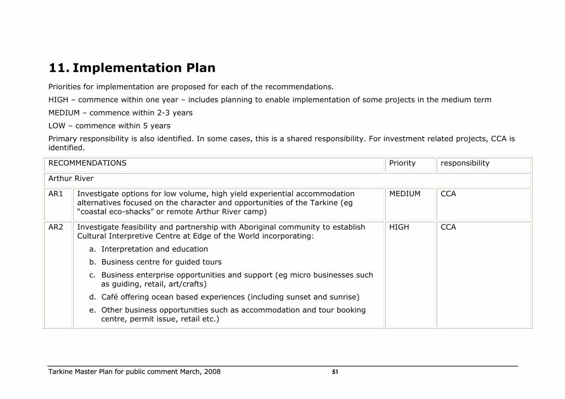
TTaarrkkiinnee MMaasstteerr PPllaann ffoorr ppuubblliicc ccoommmmeenntt MMaarrcchh,, 22000088 5511
11. Implementation Plan
Priorities for implementation are proposed for each of the recommendations.
HIGH – commence within one year – includes planning to enable implementation of some projects in the medium term
MEDIUM – commence within 2-3 years
LOW – commence within 5 years
Primary responsibility is also identified. In some cases, this is a shared responsibility. For investment related projects, CCA is
identified.
RECOMMENDATIONS Priority responsibility
Arthur River
AR1 Investigate options for low volume, high yield experiential accommodation
alternatives focused on the character and opportunities of the Tarkine (eg “coastal eco-shacks” or remote Arthur River camp)
MEDIUM CCA
AR2 Investigate feasibility and partnership with Aboriginal community to establish Cultural Interpretive Centre at Edge of the World incorporating:
a. Interpretation and education
b. Business centre for guided tours
c. Business enterprise opportunities and support (eg micro businesses such
as guiding, retail, art/crafts)
d. Café offering ocean based experiences (including sunset and sunrise)
e. Other business opportunities such as accommodation and tour booking centre, permit issue, retail etc.)
HIGH CCA
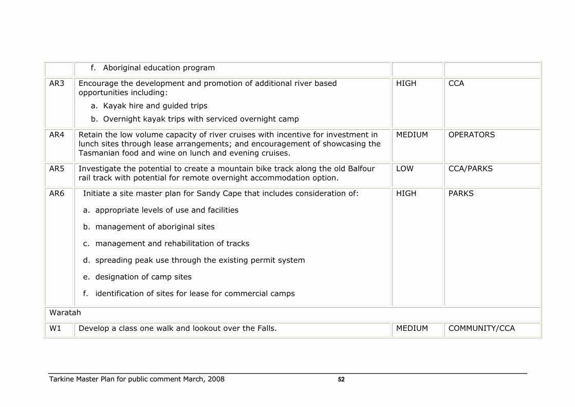
TTaarrkkiinnee MMaasstteerr PPllaann ffoorr ppuubblliicc ccoommmmeenntt MMaarrcchh,, 22000088 5522
f. Aboriginal education program
AR3 Encourage the development and promotion of additional river based
opportunities including:
a. Kayak hire and guided trips
b. Overnight kayak trips with serviced overnight camp
HIGH CCA
AR4 Retain the low volume capacity of river cruises with incentive for investment in lunch sites through lease arrangements; and encouragement of showcasing the
Tasmanian food and wine on lunch and evening cruises.
MEDIUM OPERATORS
AR5 Investigate the potential to create a mountain bike track along the old Balfour
rail track with potential for remote overnight accommodation option.
LOW CCA/PARKS
AR6 Initiate a site master plan for Sandy Cape that includes consideration of:
a. appropriate levels of use and facilities
b. management of aboriginal sites
c. management and rehabilitation of tracks
d. spreading peak use through the existing permit system
e. designation of camp sites
f. identification of sites for lease for commercial camps
HIGH PARKS
Waratah
W1 Develop a class one walk and lookout over the Falls. MEDIUM COMMUNITY/CCA
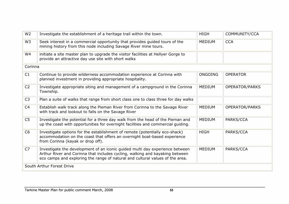
TTaarrkkiinnee MMaasstteerr PPllaann ffoorr ppuubblliicc ccoommmmeenntt MMaarrcchh,, 22000088 5533
W2 Investigate the establishment of a heritage trail within the town. HIGH COMMUNITY/CCA
W3 Seek interest in a commercial opportunity that provides guided tours of the
mining history from this node including Savage River mine tours.
MEDIUM CCA
W4 initiate a site master plan to upgrade the visitor facilities at Hellyer Gorge to
provide an attractive day use site with short walks
Corinna
C1 Continue to provide wilderness accommodation experience at Corinna with planned investment in providing appropriate hospitality.
ONGOING OPERATOR
C2 Investigate appropriate siting and management of a campground in the Corinna Township.
MEDIUM OPERATOR/PARKS
C3 Plan a suite of walks that range from short class one to class three for day walks
C4 Establish walk track along the Pieman River from Corinna to the Savage River
with track and lookout to falls on the Savage River
MEDIUM OPERATOR/PARKS
C5 Investigate the potential for a three day walk from the head of the Pieman and
up the coast with opportunities for overnight facilities and commercial guiding.
MEDIUM PARKS/CCA
C6 Investigate options for the establishment of remote (potentially eco-shack)
accommodation on the coast that offers an overnight boat-based experience from Corinna (kayak or drop off).
HIGH PARKS/CCA
C7 Investigate the development of an iconic guided multi day experience between Arthur River and Corinna that includes cycling, walking and kayaking between eco camps and exploring the range of natural and cultural values of the area.
MEDIUM PARKS/CCA
South Arthur Forest Drive
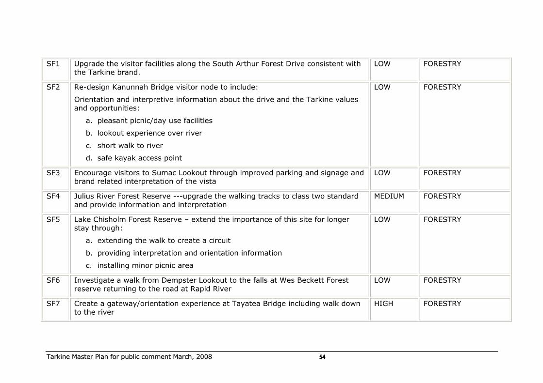
TTaarrkkiinnee MMaasstteerr PPllaann ffoorr ppuubblliicc ccoommmmeenntt MMaarrcchh,, 22000088 5544
SF1 Upgrade the visitor facilities along the South Arthur Forest Drive consistent with the Tarkine brand.
LOW FORESTRY
SF2 Re-design Kanunnah Bridge visitor node to include:
Orientation and interpretive information about the drive and the Tarkine values and opportunities:
a. pleasant picnic/day use facilities
b. lookout experience over river
c. short walk to river
d. safe kayak access point
LOW FORESTRY
SF3 Encourage visitors to Sumac Lookout through improved parking and signage and brand related interpretation of the vista
LOW FORESTRY
SF4 Julius River Forest Reserve ---upgrade the walking tracks to class two standard and provide information and interpretation
MEDIUM FORESTRY
SF5 Lake Chisholm Forest Reserve – extend the importance of this site for longer stay through:
a. extending the walk to create a circuit
b. providing interpretation and orientation information
c. installing minor picnic area
LOW FORESTRY
SF6 Investigate a walk from Dempster Lookout to the falls at Wes Beckett Forest reserve returning to the road at Rapid River
LOW FORESTRY
SF7 Create a gateway/orientation experience at Tayatea Bridge including walk down to the river
HIGH FORESTRY
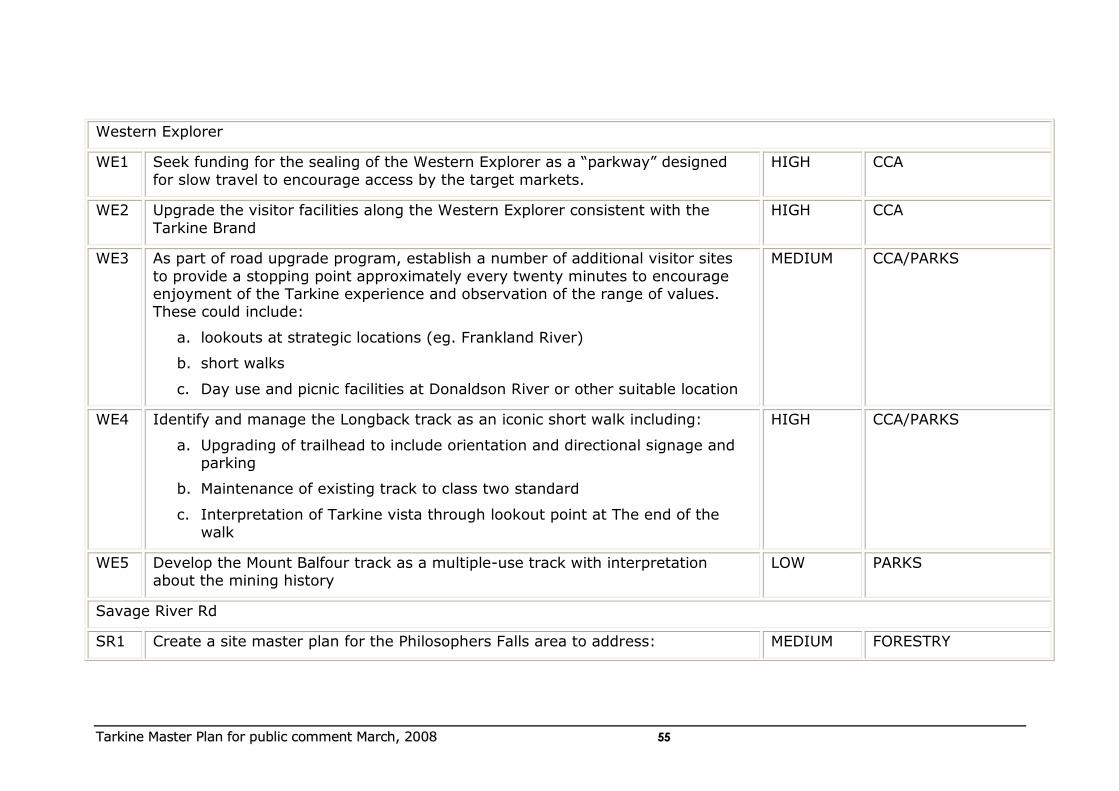
TTaarrkkiinnee MMaasstteerr PPllaann ffoorr ppuubblliicc ccoommmmeenntt MMaarrcchh,, 22000088 5555
Western Explorer
WE1 Seek funding for the sealing of the Western Explorer as a “parkway” designed
for slow travel to encourage access by the target markets.
HIGH CCA
WE2 Upgrade the visitor facilities along the Western Explorer consistent with the
Tarkine Brand
HIGH CCA
WE3 As part of road upgrade program, establish a number of additional visitor sites
to provide a stopping point approximately every twenty minutes to encourage enjoyment of the Tarkine experience and observation of the range of values. These could include:
a. lookouts at strategic locations (eg. Frankland River)
b. short walks
c. Day use and picnic facilities at Donaldson River or other suitable location
MEDIUM CCA/PARKS
WE4 Identify and manage the Longback track as an iconic short walk including:
a. Upgrading of trailhead to include orientation and directional signage and parking
b. Maintenance of existing track to class two standard
c. Interpretation of Tarkine vista through lookout point at The end of the walk
HIGH CCA/PARKS
WE5 Develop the Mount Balfour track as a multiple-use track with interpretation about the mining history
LOW PARKS
Savage River Rd
SR1 Create a site master plan for the Philosophers Falls area to address: MEDIUM FORESTRY
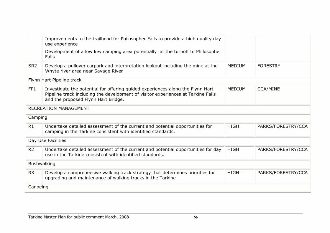
TTaarrkkiinnee MMaasstteerr PPllaann ffoorr ppuubblliicc ccoommmmeenntt MMaarrcchh,, 22000088 5566
Improvements to the trailhead for Philosopher Falls to provide a high quality day use experience
Development of a low key camping area potentially at the turnoff to Philosopher
Falls
SR2 Develop a pullover carpark and interpretation lookout including the mine at the
Whyte river area near Savage River
MEDIUM FORESTRY
Flynn Hart Pipeline track
FP1 Investigate the potential for offering guided experiences along the Flynn Hart Pipeline track including the development of visitor experiences at Tarkine Falls
and the proposed Flynn Hart Bridge.
MEDIUM CCA/MINE
RECREATION MANAGEMENT
Camping
R1 Undertake detailed assessment of the current and potential opportunities for
camping in the Tarkine consistent with identified standards.
HIGH PARKS/FORESTRY/CCA
Day Use Facilities
R2 Undertake detailed assessment of the current and potential opportunities for day use in the Tarkine consistent with identified standards.
HIGH PARKS/FORESTRY/CCA
Bushwalking
R3 Develop a comprehensive walking track strategy that determines priorities for upgrading and maintenance of walking tracks in the Tarkine
HIGH PARKS/FORESTRY/CCA
Canoeing
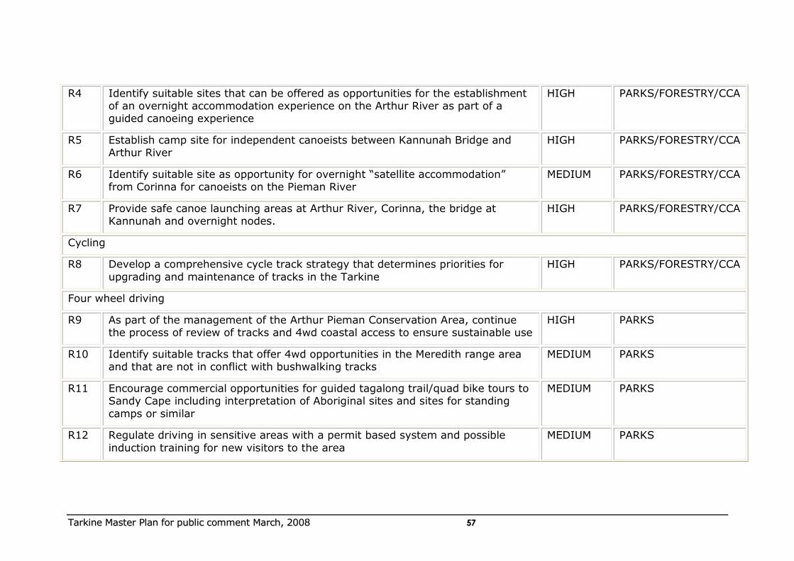
TTaarrkkiinnee MMaasstteerr PPllaann ffoorr ppuubblliicc ccoommmmeenntt MMaarrcchh,, 22000088 5577
R4 Identify suitable sites that can be offered as opportunities for the establishment of an overnight accommodation experience on the Arthur River as part of a guided canoeing experience
HIGH PARKS/FORESTRY/CCA
R5 Establish camp site for independent canoeists between Kannunah Bridge and Arthur River
HIGH PARKS/FORESTRY/CCA
R6 Identify suitable site as opportunity for overnight “satellite accommodation” from Corinna for canoeists on the Pieman River
MEDIUM PARKS/FORESTRY/CCA
R7 Provide safe canoe launching areas at Arthur River, Corinna, the bridge at Kannunah and overnight nodes.
HIGH PARKS/FORESTRY/CCA
Cycling
R8 Develop a comprehensive cycle track strategy that determines priorities for
upgrading and maintenance of tracks in the Tarkine
HIGH PARKS/FORESTRY/CCA
Four wheel driving
R9 As part of the management of the Arthur Pieman Conservation Area, continue the process of review of tracks and 4wd coastal access to ensure sustainable use
HIGH PARKS
R10 Identify suitable tracks that offer 4wd opportunities in the Meredith range area and that are not in conflict with bushwalking tracks
MEDIUM PARKS
R11 Encourage commercial opportunities for guided tagalong trail/quad bike tours to Sandy Cape including interpretation of Aboriginal sites and sites for standing
camps or similar
MEDIUM PARKS
R12 Regulate driving in sensitive areas with a permit based system and possible
induction training for new visitors to the area
MEDIUM PARKS
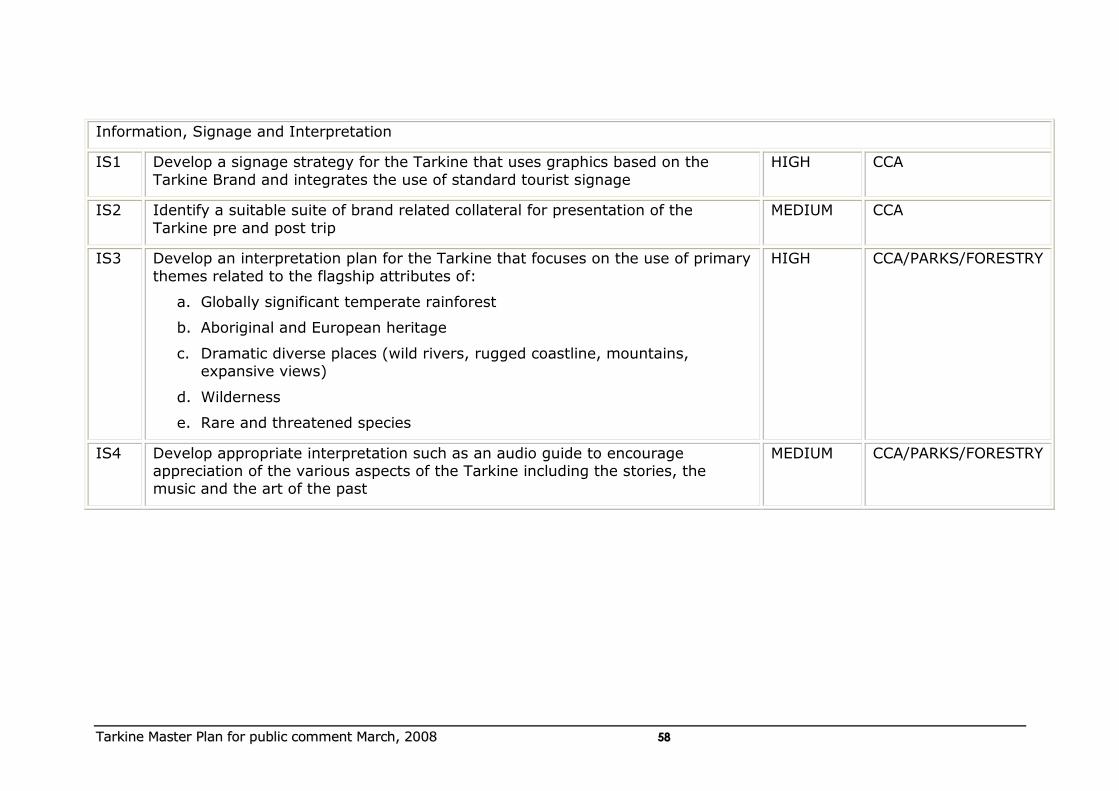
TTaarrkkiinnee MMaasstteerr PPllaann ffoorr ppuubblliicc ccoommmmeenntt MMaarrcchh,, 22000088 5588
Information, Signage and Interpretation
IS1 Develop a signage strategy for the Tarkine that uses graphics based on the
Tarkine Brand and integrates the use of standard tourist signage
HIGH CCA
IS2 Identify a suitable suite of brand related collateral for presentation of the
Tarkine pre and post trip
MEDIUM CCA
IS3 Develop an interpretation plan for the Tarkine that focuses on the use of primary
themes related to the flagship attributes of:
a. Globally significant temperate rainforest
b. Aboriginal and European heritage
c. Dramatic diverse places (wild rivers, rugged coastline, mountains, expansive views)
d. Wilderness
e. Rare and threatened species
HIGH CCA/PARKS/FORESTRY
IS4 Develop appropriate interpretation such as an audio guide to encourage appreciation of the various aspects of the Tarkine including the stories, the music and the art of the past
MEDIUM CCA/PARKS/FORESTRY
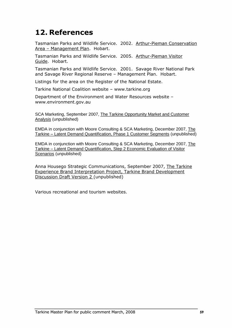
TTaarrkkiinnee MMaasstteerr PPllaann ffoorr ppuubblliicc ccoommmmeenntt MMaarrcchh,, 22000088 5599
12. References
Tasmanian Parks and Wildlife Service. 2002. Arthur-Pieman Conservation Area – Management Plan. Hobart.
Tasmanian Parks and Wildlife Service. 2005. Arthur-Pieman Visitor Guide. Hobart.
Tasmanian Parks and Wildlife Service. 2001. Savage River National Park and Savage River Regional Reserve – Management Plan. Hobart.
Listings for the area on the Register of the National Estate.
Tarkine National Coalition website – www.tarkine.org
Department of the Environment and Water Resources website –
www.environment.gov.au
SCA Marketing, September 2007, The Tarkine Opportunity Market and Customer Analysis (unpublished) EMDA in conjunction with Moore Consulting & SCA Marketing, December 2007, The Tarkine – Latent Demand Quantification, Phase 1 Customer Segments (unpublished) EMDA in conjunction with Moore Consulting & SCA Marketing, December 2007, The Tarkine – Latent Demand Quantification, Step 2 Economic Evaluation of Visitor Scenarios (unpublished)
Anna Housego Strategic Communications, September 2007, The Tarkine Experience Brand Interpretation Project, Tarkine Brand Development Discussion Draft Version 2 (unpublished)
Various recreational and tourism websites.
TTaarrkkiinnee MMaasstteerr PPllaann ffoorr ppuubblliicc ccoommmmeenntt MMaarrcchh,, 22000088 6600
APPENDIX 1 An Article about the Tarkine written in 2015
“So lets go somewhere new and more remote but it has to be near the coast” That was what we concluded for our next holiday as we were driving back
from Byron Bay. The East coast is nice but very crowded and hard to find a remote spot where you can experience nature.
That night we scanned a map of Australia to plan our next self drive family holiday. Along the whole East coast we struggled to find some remote coastline which met our expectations. So we tried the internet and typed in
the words wilderness and Australian coast and up popped the “Tarkine” in Tasmania. We went to this new tourism website about the Tarkine region. It
showed us inspiring natural images of the coast and forest. We learnt that the region had a comprehensive range of new nature based tourism facilities
and products including canoeing up remote rivers, beach walking, 4wd drive tours, cattle droving tours, horse-riding, fishing, forest walks, great surfing, and wildlife. We were excited as Tasmania is always alluring and this corner
of Tasmania we didn’t know much about.
So a year later we drove down to Melbourne and loaded onto the Tassie
Ferry. The kids loved the experience of the ferry and were excited about visiting what seemed like another country.
We hadn’t fully planned our holiday. We decided to do the Tarkine loop road
and see what happens. We also wanted to do something nature based and adventurous as a family.
We landed at Devonport and within two hours were at Stanley on the edge of the Tarkine region. After a great stay in Stanley we headed towards Arthur River – the Gateway town to the Tarkine. The kids were keen to go to
Dismal Swamp which was famous for its treetop slide. We pulled into the car park in amongst the tall trees. The place was hidden in the forest and
wonderfully designed. We were excited as we approach the elevated building perched out into the tree tops. We spent half a day here going on the surprisingly exhilarating slide and doing some forest walks and bike rides and
lunching at the restaurant.
We had a very pleasant drive to Arthur River after lunch. The rolling green
farmland was a welcome relief to the brown flat landscapes from where we had come. We were tempted to explore the little towns along the way, but were keen on reaching Arthur River. Already we had decided that we needed
to come back to see spots that we were missing !!
We arrived at Arthur river which was a small and bustling coastal settlement.
You didn’t feel like you were in a town with a swollen visitor population as all the development was tucked away. The moods of the river and the powerful Southern Ocean still ruled this town ! We were naturally directed by signs
over the bridge to a mysterious place called “Edge of the World”. We ended up here approaching sunset. We parked the car and entered the Cultural
TTaarrkkiinnee MMaasstteerr PPllaann ffoorr ppuubblliicc ccoommmmeenntt MMaarrcchh,, 22000088 6611
Centre which was a beautifully designed building which merged into the coastal dunes and contained heaps of information and quality interpretation
about the region.
But first we were drawn along a boardwalk to a lookout point overlooking the
Southern Ocean. The view I saw became one of my most memorable visions. Massive waves were steamrolling into the river mouth and colliding with the outgoing river creating a maelstrom of water. It was more than a
vision though - it was something very raw and fresh almost spiritual. We were standing on the last bit of land for a distance half way around the earth.
The waves and wind would have travelled across one of the most wild and lengthy oceans in the world. All this to the backdrop of the setting sun. We gazed at the scene until the cold Southern Ocean wind nibbled at our bones.
Now we understood why this was called “Edge of the World”. The kids were even transfixed. This image I later learned typified the Tarkine – wild,
powerful, raw, and beautiful.
That night we stayed within earshot of the ocean in a comfortable eco friendly cabin. There was a surprising choice of accommodation in Arthur
River from camping to 4 star comfort. The choice of quality food was also surprising. We had dinner at the local restaurant which showcased the local
marine cuisine.
In the morning we went back to Edge of the World to more thoroughly
explore the interpretation, and plan our holiday. The Cultural Centre had state of the art audiovisual information about the area including: the 20 m high middens and aboriginal townships done the coast; the early cattle
drovers; shack settlements; muttonbirds; marine mammals; forestry; commercial fishing; and miners. It was fascinating how this rugged coastline
had created so many rugged ways of living. We also snuck into the theatrette to hear a pre-tour talk about driving down the coast to Sandy Cape eco camp. The Aboriginal guide gave a comprehensive talk about the
cultural and natural values of the area and how we need to protect it. He told us how previously the area was almost loved to death by vehicles.
The centre was also a great place to plan the rest of our holiday. There was such a range of activities from fishing charters to canoeing and camping. There were even helicopter trips to remote eco lodges for those with a bit
more money and seeking an instant wilderness experience. We chose to do a guided 3 day boating, canoeing and bushwalking trip. We left the centre
feeling invigorated and ready to explore this very special part of Australia.
The next day we went down to the wharf and joined our friendly guide and a couple from Sydney who were also doing the trip. They had just come up
from Corinna and had done a coastal walk which they raved about. The first leg of the trip was by motor boat up the Arthur river. Our guide gave us a
great introduction to the plants and animals and history of the area. We then stopped at a small picnic area on the banks of the river, had lunch and hoped into canoes and paddled off. The river started to get narrower and the
coastal heath turned to ancient forest. A sea eagle circled high above us and fish were jumping in the water. It was beautiful and so quiet. We arrived at
TTaarrkkiinnee MMaasstteerr PPllaann ffoorr ppuubblliicc ccoommmmeenntt MMaarrcchh,, 22000088 6622
our overnight camp. It was a simple environmentally sustainable lodge tucked into the forest with views down the river. We even had a hot shower.
We also had the option of staying in tents. In the morning we started on our next leg of the trip. Our guide led us through the forest on foot until we
reached the wide buttongrass plains with views to the coast. We eventually came to another river and our second overnight eco cabin. Here we met some other people and had a great time talking about our travels and
adventures. The final day we canoed down the Franklin river back to the junction with Arthur River. There were even few rapids to excite us all. It
was an outstanding trip. We went through so many environments – the river, the forest and buttongrass plains. We also visited some old mining ruins and old aboriginal campsite. There were so many interesting
experiences. The trip was very professionally run with good guides and equipment and great choice.
We headed of from Arthur River after touring around some of the coastal shack settlements and chatting to the local fishermen. We were heading for Corinna. The road was surprisingly scenic as we wound our way inland
across the vast buttongrass plains with 360 degree views to the inland mountain ranges and West towards to the coast. Every half an hour there
was a place to stop, walk and learn about the landscape. We didn’t feel the need to rush as there was so much to see. From the plains we entered the
deep valleys of the Donaldson and Savage rivers. We eventually arrived at the oasis of Corinna. It was such a cute little settlement once again not overdeveloped but somehow able to cater for a number of tourists without
feeling overcrowded. We stayed here for a special two days. We did all the local walks and the famous boat trip downstream towards the Pieman river
heads. There were so many interesting stories about the early pioneers of the area and the mining and forestry industry. There was so much else we could have done – the Pieman overnight coastal walk, the Mt Donaldson
Walk, canoeing. We could also have used Corrina as a base and explored further south towards Zeehan and Rosebury.
We set of to the historic town of Warratah. Along the way there were numerous interesting stops including the mining town of Savage River where we took an interesting mine tour. Warratah was a real surprise – not your
typical Australian town. It had a waterfall in the middle of town ! We had only planned a short time here but could have stayed here much longer as
there was so much to see. Reluctantly we set of on our last leg of the Tarkine loop, back through Hellyer Gorge to Devonport.
On the Boat back to Melbourne we met up with the Sydney couple who came
with us on the 3 day trip out of Arthur river. They also had a fantastic time. They did the wilderness forest walk and helicopter trip which they said was
world class. We all agreed that the region was special with its variety of outstanding landscapes, Aboriginal and settlement history, and the range of tourist experiences. What was especially satisfying about the trip was that
we all learnt so much, especially the kids. Initially we came to the Tarkine for its natural landscapes, but we left with a great appreciation about its rich
and varied history and culture. We will definitely be coming back.
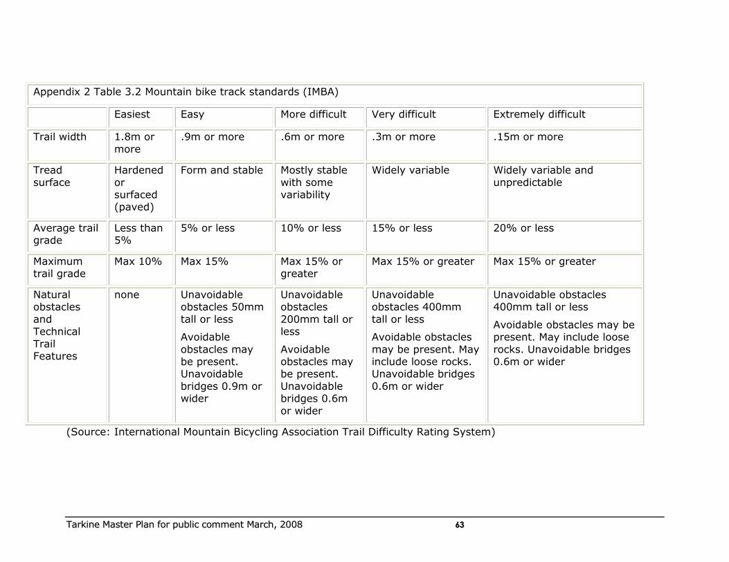
TTaarrkkiinnee MMaasstteerr PPllaann ffoorr ppuubblliicc ccoommmmeenntt MMaarrcchh,, 22000088 6633
Appendix 2 Table 3.2 Mountain bike track standards (IMBA)
Easiest Easy More difficult Very difficult Extremely difficult
Trail width 1.8m or
more
.9m or more .6m or more .3m or more .15m or more
Tread
surface
Hardened
or surfaced (paved)
Form and stable Mostly stable
with some variability
Widely variable Widely variable and
unpredictable
Average trail grade
Less than 5%
5% or less 10% or less 15% or less 20% or less
Maximum trail grade
Max 10% Max 15% Max 15% or greater
Max 15% or greater Max 15% or greater
Natural obstacles
and Technical
Trail Features
none Unavoidable obstacles 50mm
tall or less
Avoidable
obstacles may be present. Unavoidable
bridges 0.9m or wider
Unavoidable obstacles
200mm tall or less
Avoidable obstacles may be present.
Unavoidable bridges 0.6m
or wider
Unavoidable obstacles 400mm
tall or less
Avoidable obstacles
may be present. May include loose rocks. Unavoidable bridges
0.6m or wider
Unavoidable obstacles 400mm tall or less
Avoidable obstacles may be present. May include loose
rocks. Unavoidable bridges 0.6m or wider
(Source: International Mountain Bicycling Association Trail Difficulty Rating System)
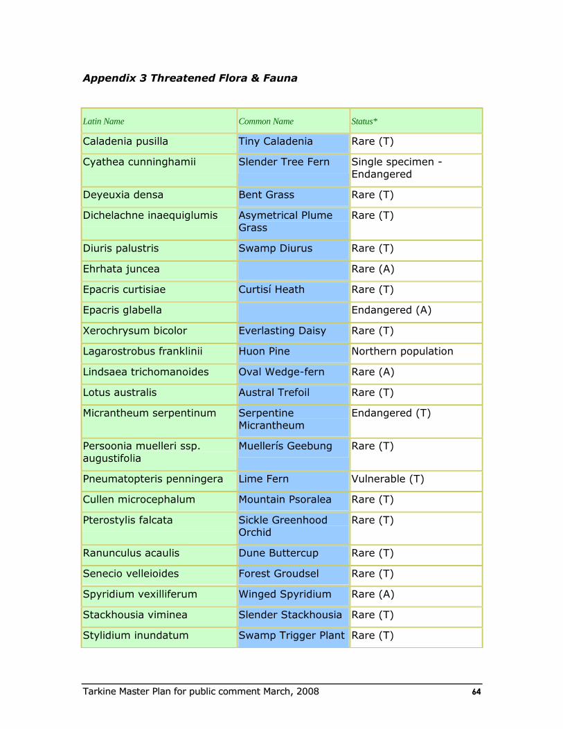
TTaarrkkiinnee MMaasstteerr PPllaann ffoorr ppuubblliicc ccoommmmeenntt MMaarrcchh,, 22000088 6644
Appendix 3 Threatened Flora & Fauna
Latin Name Common Name Status*
Caladenia pusilla Tiny Caladenia Rare (T)
Cyathea cunninghamii Slender Tree Fern Single specimen -
Endangered
Deyeuxia densa Bent Grass Rare (T)
Dichelachne inaequiglumis Asymetrical Plume
Grass
Rare (T)
Diuris palustris Swamp Diurus Rare (T)
Ehrhata juncea Rare (A)
Epacris curtisiae Curtisí Heath Rare (T)
Epacris glabella Endangered (A)
Xerochrysum bicolor Everlasting Daisy Rare (T)
Lagarostrobus franklinii Huon Pine Northern population
Lindsaea trichomanoides Oval Wedge-fern Rare (A)
Lotus australis Austral Trefoil Rare (T)
Micrantheum serpentinum Serpentine
Micrantheum
Endangered (T)
Persoonia muelleri ssp.
augustifolia
Muellerís Geebung Rare (T)
Pneumatopteris penningera Lime Fern Vulnerable (T)
Cullen microcephalum Mountain Psoralea Rare (T)
Pterostylis falcata Sickle Greenhood Orchid
Rare (T)
Ranunculus acaulis Dune Buttercup Rare (T)
Senecio velleioides Forest Groudsel Rare (T)
Spyridium vexilliferum Winged Spyridium Rare (A)
Stackhousia viminea Slender Stackhousia Rare (T)
Stylidium inundatum Swamp Trigger Plant Rare (T)
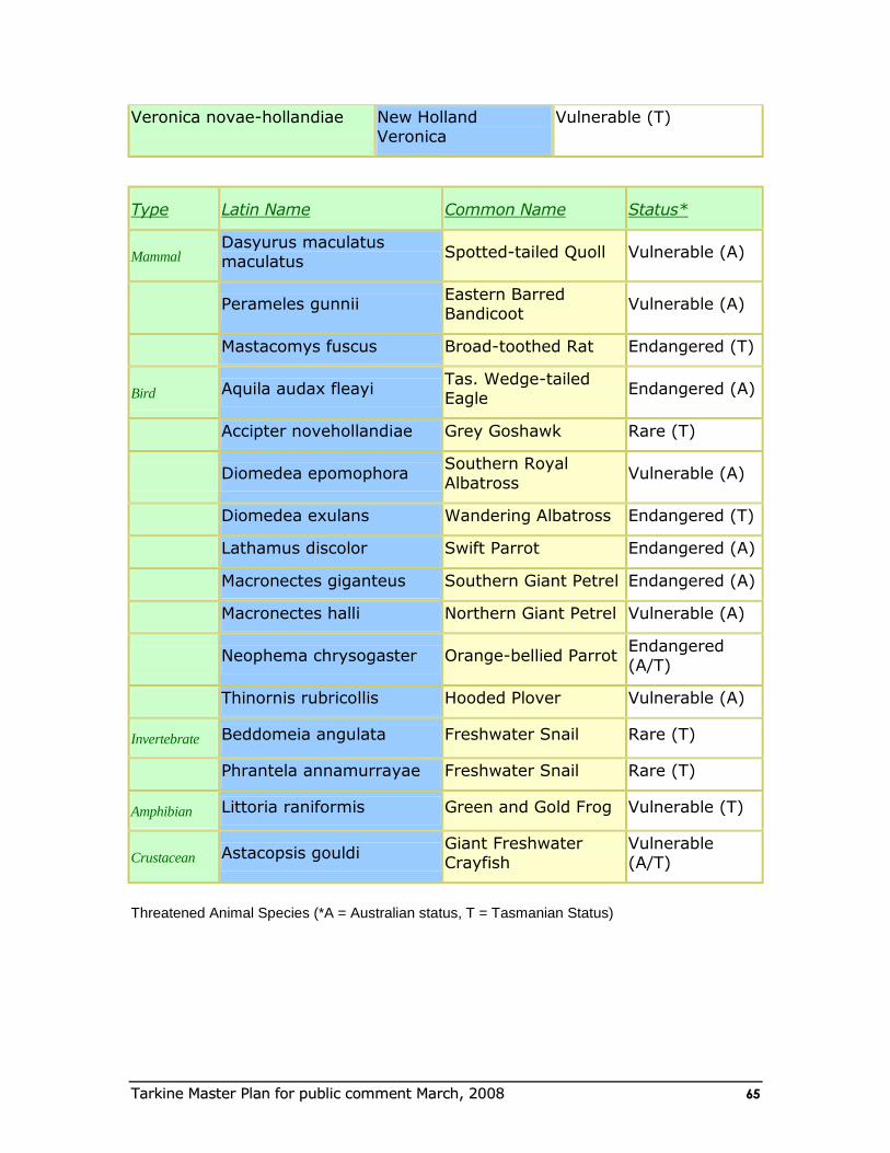
TTaarrkkiinnee MMaasstteerr PPllaann ffoorr ppuubblliicc ccoommmmeenntt MMaarrcchh,, 22000088 6655
Veronica novae-hollandiae New Holland Veronica
Vulnerable (T)
Type Latin Name Common Name Status*
Mammal Dasyurus maculatus maculatus
Spotted-tailed Quoll Vulnerable (A)
Perameles gunnii Eastern Barred Bandicoot
Vulnerable (A)
Mastacomys fuscus Broad-toothed Rat Endangered (T)
Bird Aquila audax fleayi Tas. Wedge-tailed Eagle
Endangered (A)
Accipter novehollandiae Grey Goshawk Rare (T)
Diomedea epomophora Southern Royal
Albatross Vulnerable (A)
Diomedea exulans Wandering Albatross Endangered (T)
Lathamus discolor Swift Parrot Endangered (A)
Macronectes giganteus Southern Giant Petrel Endangered (A)
Macronectes halli Northern Giant Petrel Vulnerable (A)
Neophema chrysogaster Orange-bellied Parrot Endangered (A/T)
Thinornis rubricollis Hooded Plover Vulnerable (A)
Invertebrate Beddomeia angulata Freshwater Snail Rare (T)
Phrantela annamurrayae Freshwater Snail Rare (T)
Amphibian Littoria raniformis Green and Gold Frog Vulnerable (T)
Crustacean Astacopsis gouldi Giant Freshwater Crayfish
Vulnerable (A/T)
Threatened Animal Species (*A = Australian status, T = Tasmanian Status)