Embed Size (px)
Citation preview
ISSN: 0214-1744
Revista&
ANTHROPOGENICALLY-INDUCED EROSION IN ARID ANDSEMIARID AUSTRALIA
Erosión en zonas áridas y semiáridas inducida antrópicamente: el ejemplo de Australia
C.R. Twidale
School of Earth and Environmental Sciences, Geology and Geophysics, University of Adelaide,Adelaide, South Australia 5005
Fax: 61+8+ 8303 4347; E-mail: [email protected]
Resumen: Aproximadamente un tercio del continente australiano es árido y un tercio semiárido. Estas areas se locali-zan de manera dispersa aunque todas ellas se ven afectadas por las actividades humanas. Extensas áreas se usan parael pastoreo, otras tiene un uso agrícola y algunas otras tienen un uso mixto para labradío. Se han encontrado impor-tantes depósitos minerales en las zonas desérticas y la investigación continua. El turismo es progresivamente masimportante. La cubierta vegetal ha sido eliminada accidentalmente o por la construcción de sendas, caminos, carrete-ras o líneas férreas. Se han introducido plantas o animales exóticos. Las tierras han sido labradas y el freático ha sidorebajado aquí y elevado allí, en este último caso resultando en una generalizada salinización del suelo. Estas activida-des han convertido la superficie de la tierra en más vulnerable a la erosión. La erosión acelerada del suelo, expresadode manera más evidente en el acarcavamiento, pero de manera más importante en la erosión por arroyada difusa haocasionado la pérdida del horizonte A de manera generalizada. En el momento actual está en marcha un genuino epi-ciclo de erosión (y deposición).
Palabras clave: Tierras áridas y semiáridas; Erosión acelerado; Impactos antrópicos; Restauración; Australia Central.
Abstract: Roughly one third of the Australian continent is arid and one third semiarid. These areas are sparsely set-tled, yet all are affected by human activities. Large areas are under pastoral lease, some are agricultural, and some arein mixed farming. Important ore deposits have been found in the desert and the search continues. Tourism is increa-singly important. Vegetation has been cleared by accident or by design and paths, tracks, roads and railways construc-ted. Exotic plants and animals have been introduced. The land has been ploughed, the water table lowered here, butraised there, in the latter case resulting in widespread soil salinisation. These activities have rendered the land surfacevulnerable to erosion. Accelerated soil erosion, most obviously in the form of gullying but more importantly sheet ero-sion, involving the stripping of the A-horizon, is widespread. A veritable epicycle of erosion (and deposition) is in train.
Key words: Arid and semiarid lands; Accelerated erosion; Human impacts; Restoration; Central Australia
C.R. Twidale (2004) Anthropogenically-induced erosion in arid and semiarid lands. Rev. C. & G.,18 (3-4), 29-42.
S.E.G.
1. Introduction
Forensic scientists believe devoutly in Locard’sPrinciple. Locard (1877-1966) was a distinguishedFrench detective who realised that humans cannot goanywhere without leaving evidence of their presence.
As a corollary, they themselves are contaminated bythe site environment, for when moving on theyinevitably take with them some elements of the sitevisited. The same sort of principle applies also to thelandscape. Wherever they go humans have changedtheir environments, most commonly to the longer-
30 C.R. Twidale (2004). Rev. C&G, 18 (3-4)
term detriment of both. Moreover the results of theiractivities eventually come back to haunt humans forthey cannot escape the legacy of an impoverishedand damaged environment. Human impacts on thelandscape are, however, even more pervasive thanL o c a r d ’s Principle suggests, for people do not needto be physically present for their activities to modify,or even destroy, an environment. Airborne toxicwastes generated by smelters has affected entire dis-tricts, as for example the vegetational desert aroundQueenstown, western Tasmania, the acid rain ema-nating from industrial regions of western Europeextends downwind and damages forests far beyondthe sites where the poison is generated, and the CFC(chlorofluorocarbon)-induced polar ozone holes arefar removed from their areas of origin.
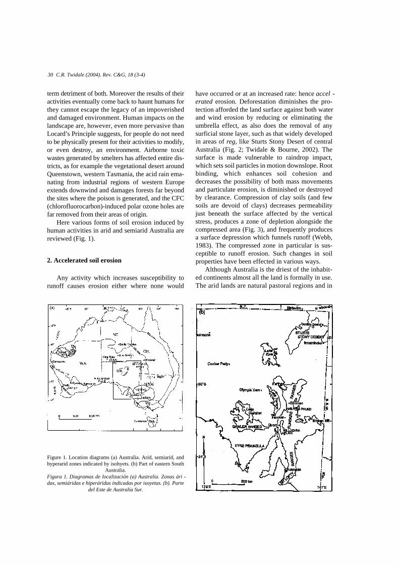
Here various forms of soil erosion induced byhuman activities in arid and semiarid Australia arereviewed (Fig. 1).
2. Accelerated soil erosion
Any activity which increases susceptibility torunoff causes erosion either where none would
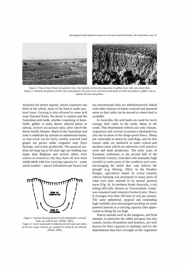
have occurred or at an increased rate: hence accel -erated erosion. Deforestation diminishes the pro-tection afforded the land surface against both waterand wind erosion by reducing or eliminating theumbrella effect, as also does the removal of anysurficial stone layer, such as that widely developedin areas of reg, like Sturts Stony Desert of centralAustralia (Fig. 2; Twidale & Bourne, 2002). Thesurface is made vulnerable to raindrop impact,which sets soil particles in motion downslope. Rootbinding, which enhances soil cohesion anddecreases the possibility of both mass movementsand particulate erosion, is diminished or destroyedby clearance. Compression of clay soils (and fewsoils are devoid of clays) decreases permeabilityjust beneath the surface affected by the verticalstress, produces a zone of depletion alongside thecompressed area (Fig. 3), and frequently producesa surface depression which funnels runoff (Webb,1983). The compressed zone in particular is sus-ceptible to runoff erosion. Such changes in soilproperties have been effected in various ways.
Although Australia is the driest of the inhabit-ed continents almost all the land is formally in use.The arid lands are natural pastoral regions and in
Figure 1. Location diagrams (a) Australia. Arid, semiarid, andhyperarid zones indicated by isohyets. (b) Part of eastern South
Australia.Figura 1. Diagramas de localización (a) Australia. Zonas ári -das, semiáridas e hiperáridas indicadas por isoyetas. (b). Parte
del Este de Australia Sur.
Antropogenically-induced erosion in arid and semirarid lands: the Australian case 31
Australia the desert regions, which constitute onethird of the whole, most of the land is under pas-toral lease. Grazing is also allowed in some aridzone National Parks. No desert is rainless and theAustralian arid lands, whether consisting of dune-fields, gibber or stony desert, alluvial plains orsalinas, receive occasional rains, after which thedesert briefly blooms. Much of the Australian aridzone is underlain by artesian or subartesian basins,so that stock can be fairly readily watered (andgrapes are grown under irrigation near A l i c eSprings, and wines produced). The pastoral sta-tions are large (up to 50 years ago one holding wasl a rger than Belgium and several others werealmost as extensive, but they have all now beensubdivided) with low carrying capacity (n – somesmall number - square kilometres per beast) and
not uncommonly they are administratively linkedwith other stations in better-watered and pasturedareas so that cattle can be moved to where feed isa v a i l a b l e .
In Australia, the arid lands are used for stockrearing: beef cattle in the north, sheep in thesouth. This distribution reflects not only climate,vegetation and current economics (demand) butalso the location of the dingo-proof fence. Sheepare vulnerable to attack by wild dogs, and for thisreason cattle are preferred in some central andnorthern areas which are otherwise well suited towool and lamb production. The early years ofEuropean settlement in the second half of theTwentieth Century coincided with unusually highrainfall in some parts of the southern arid zone,encouraging the belief that ‘rain follows thep l o u g h ’ (e.g. Meinig, 1962). In the FlindersRanges, agriculture based on cereal (mainlywheat) farming was attempted in many parts ofwhat were later realised to be natural pastoralareas (Fig. 4). In northern South Australia, a railsiding officially known as ‘Government Gums’was renamed (and remains) Farina (Latin, flour).It averages less than 160 mm of rain per annum.The same ephemeral, atypical and misleadinghigh rainfalls also encouraged stocking on somepastoral stations at a carrying capacity later appre-ciated as being far too high.
Native animals such as the kangaroo, and feralanimals, in particular the rabbit and goat, but alsocamels, horses (brumbies) and donkeys, are wellknown for their capacity to multiply and for thedepredations they have wrought on the vegetation
Figure 2. Sturts Stony Desert (a) general view, (b) roadside section showing stone or gibber layer only one stone thick.Figura 2. Desierto de piedras de Sturt (a) vista general, (b) corte en la carretera mostrando un lecho de piedras o gibber con un
espesor de una sola piedra.
Figure 3. Section showing strain in soil underneath a verticalload, e.g. vehicle tyre. (Webb, 1983).
Figura 3. Corte mostrando la deformación del suelo por deba -jo de una carga vertical, por ejemplo la rueda de un vehículo.
(Webb, 1983).
cover in arid and semiarid Australia (e.g.R a t c l i ffe, 1936, 1937, 1938; McKnight, 1976).The pads they make going to and from water, andalong fence lines, also contribute to the soil ero-sion hazard.
Road construction in the Australian desertposes insoluble problems. In Sturts Stony Desert,for example, grading the roads strips the surficialstone layer. This is desirable because the angular,hard, silcrete fragments not only give a roughride which is hard on vehicle suspension but alsotear and shred tyres. Such grading also exposesthe clays beneath the stone layer to water erosion,particularly as the roads are cambered. A l s o ,some graded material is left in ridges on eachside of the graded track, resulting in the fun-nelling and concentration of runoff. The graderoperators leave regularly spaced openings thatallow runoff to escape to the offroad areas. In
heavy rain, however, this can lead to ponds whichform temporary watering points for animals butthe water may overtop the roadside ridges a n dflood the road surface. Sealing the road would beexpensive, for the clays are expansive, so thatunless the foundation was very thick the bitu-minised surface would be disturbed (the clays areevocatively known as ‘Bay of Biscay’ soils inSouth Australia). Moreover, a sealed surfacewould be impermeable and runoff from the cam-bered surface correspondingly rapid and heavy.The risk of roadside erosion and undermining ofthe road would be high.
Sand drift can be a hazard where (as on theB i r d s v i l l e - Windorah road, and also aroundMinilya, north of Carnarvon, in the northwest ofWestern Australia) the sealed road is directedthrough trenched dunes. Furthermore, if the dunesare not cut to the same level as the road to either
32 C.R. Twidale (2004). Rev. C&G, 18 (3-4)
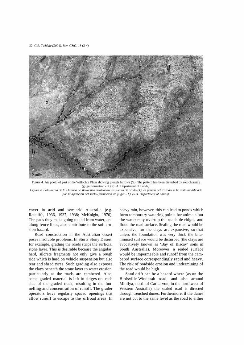
Figure 4. Air photo of part of the Willochra Plain showing plough furrows (Y). The pattern has been disturbed by soil churning(gilgai formation - X). (S.A. Department of Lands).
Figura 4. Foto aérea de la Llanura de Willochra mostrando los surcos de arado (Y). El patrón del trazado se ha visto modificadopor la agitación del suelo (formación de gilgai - X). (S.A. Department of Lands).

Antropogenically-induced erosion in arid and semirarid lands: the Australian case 33
side, blowing sand reduces visibility on alreadyblind crests.
All this has increased the exposure of an alreadyvulnerable landscape to accelerated erosion bywater and by wind. That wind is particularly eff e c-tive as an agent of transportation and deposition isattested by the many dunefields, past and present,typical of arid and semiarid lands. Transport anddeposition imply erosion, and though there are fewspecific forms due to wind erosion, a general low-ering of the surface is widely in evidence. That run-ning water is an effective erosional agent in deserts,and even especially effective, is also not surprising(Peel, 1941). It is not that desert rains are especial-ly intense – though, as elsewhere, heavy falls dooccur (Russell, 1936) – but rather that the surfaceon which the rain falls is poorly protected againstwater erosion in its various forms. The surface tendsin an immediate and surficial sense at any rate to bedried and baked. It is impermeable and thus con-ducive to rapid and high runoff .
In addition to these generalities, particularactivities invite particular types and causes ofaccelerated erosion.
3. Land use and erosion
3.1. Pastoral activity
Rearing cattle or sheep requires fences to keep thestock in paddocks where there is feed, and to controlbreeding and watering points. These in turn implytracks for maintenance and access. Fences and water-ing points also mean the funnelling of stock (as wellas native animals like kangaroos) along certain lines,the making of pads (or narrow tracks) and the forma-tion of a compressed surface soil layer which is of lowp e r m e a b i l i t y, and is flanked by narrow zones of ten-sion or spatial depletion. Despite the increasing use oflight aircraft and helicopters for mustering and otherpurposes, the making and maintenance of tracks arestill inevitable. Tracks mean vehicles, whether withfour or two wheels, and again, compaction, depres-sion and low permeability, and erosion (Fig. 5).
Stock also eat grasses and if necessary, indrought, the low branches of shrubs and trees. Bothwith intent and as a matter of course, the land ism o r e - o r-less cleared, though pastoralists have cus-tomarily left some trees to provide shelter against sun
Figure 5. Washed-out tracks (a) on Cordillo Downs station, nort-heastern South Australia, (b) in the western piedmont of FlindersRanges, near Wilpena Pound, South Australia; the track runsessentially along rather than across, the contour of the land, and (c)alongside the abandoned railway line west of Wilpena Pound, eas-tern Lake Torrens plain, South Australia. The track was used to
service the rail bed. Note the evidence of sheet wash (S).Figura 5. Sendas sujetas a lavado de finos (a) en la Estación deC o rdillo Downs, al noreste de Australia del Sur, (b) en el piedemonteoccidental de los Flinders Ranges, cerca de Wilpena Pound, A u s t r a l i adel Sur; la senda discurre mas bien a lo largo que a través del con -torno de la tierra, y (c) por el borde de la línea de ferro c a rril aban -donada cerca de Wilpena Pound, en el Este de la llanura del LagoTo rrens, Australia del Sur. La senda se usó para el servicio del traza -do del ferro c a rril. Nótense las pruebas de lavado en lámina (S).
a b
c
and weather. The soil surface is significantlydeprived of protection. Using tracks in the stonydesert has the same effect for the stone cover is onlyone layer thick (Fig. 2b). The introduction of rabbitsand goats added to the depredations of kangaroos andthe occasional swarms of locusts, plus the occasion-al impacts of bushfires, add to the problems intro-duced by vegetational clearance. Also, exotic grasseshave been introduced, either intentionally or by acci-dent. They have spread at the expense of nativespecies but they do not withstand drought and heat,
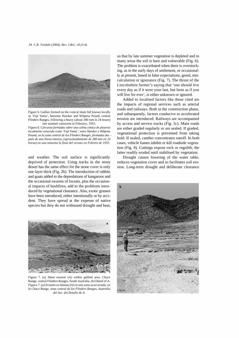
so that by late summer vegetation is depleted and inmany areas the soil is bare and vulnerable (Fig. 6).The problem is exacerbated when there is overstock-ing, as in the early days of settlement, or occasional-ly at present, based in false expectations, greed, mis-calculation or ignorance (Fig. 7). The thrust of theLincolnshire farmer’s saying that ‘one should liveevery day as if it were your last, but farm as if youwill live for ever’, is either unknown or ignored.
Added to localised factors like those cited arethe impacts of regional services such as arterialroads and railways. Both in the construction phase,and subsequently, factors conducive to acceleratederosion are introduced. Railways are accompaniedby access and service tracks (Fig. 5c). Main roadsare either graded regularly or are sealed. If graded,vegetational protection is prevented from takinghold. If sealed, camber concentrates runoff. In bothcases, vehicle fumes inhibit or kill roadside vegeta-tion (Fig. 8). Cuttings expose rock or regolith, thelatter readily eroded until stabilised by vegetation.
Drought causes lowering of the water table,reduces vegetation cover and so facilitates soil ero-sion. Long-term drought and deliberate clearance
34 C.R. Twidale (2004). Rev. C&G, 18 (3-4)
Figure 6. Gullies formed on the conical shale hill known locallyas ‘Fuji Yama’, between Hawker and Wilpena Pound, centralFlinders Ranges, following a heavy (about 280 mm in 24 hours)
late summer rainstorm in February, 1955.Figura 6. Cárcavas formadas sobre una colina cónica de pizarr a slocalmente conocida como ‘Fuji Yama’‚ entre Hawker y Wi l p e n aPound, en la zona central de los Flinders Ranges, formadas des -pués de una lluvia intensa, (aproximadamente de 280 mm en 24horas) en una tomenta la final del verano en Febre ro de 1955.
Figure 7. (a) Sheet erosion (A) within gullied area, ChaceRange, central Flinders Ranges, South Australia. (b) Detail of A.Figura 7. (a) Erosión en lámina (A) en una zona acarcavada, enla Chace Range, zona central de los Flinders Ranges, Australia
del Sur. (b) Detalle de A.
b
a
Antropogenically-induced erosion in arid and semirarid lands: the Australian case 35
cause a decrease in organic matter in the soil, and aloss of soil structure. This also is conducive to soilerosion and accounts for the observed delaybetween clearance and the onset of erosion noted insome areas (Waksman, 1938; Twidale, 1997).Local but significant losses of vegetation cover canalso be induced by boring and heavy use (mining)of shallow groundwaters around small towns andeven large pastoral stations.
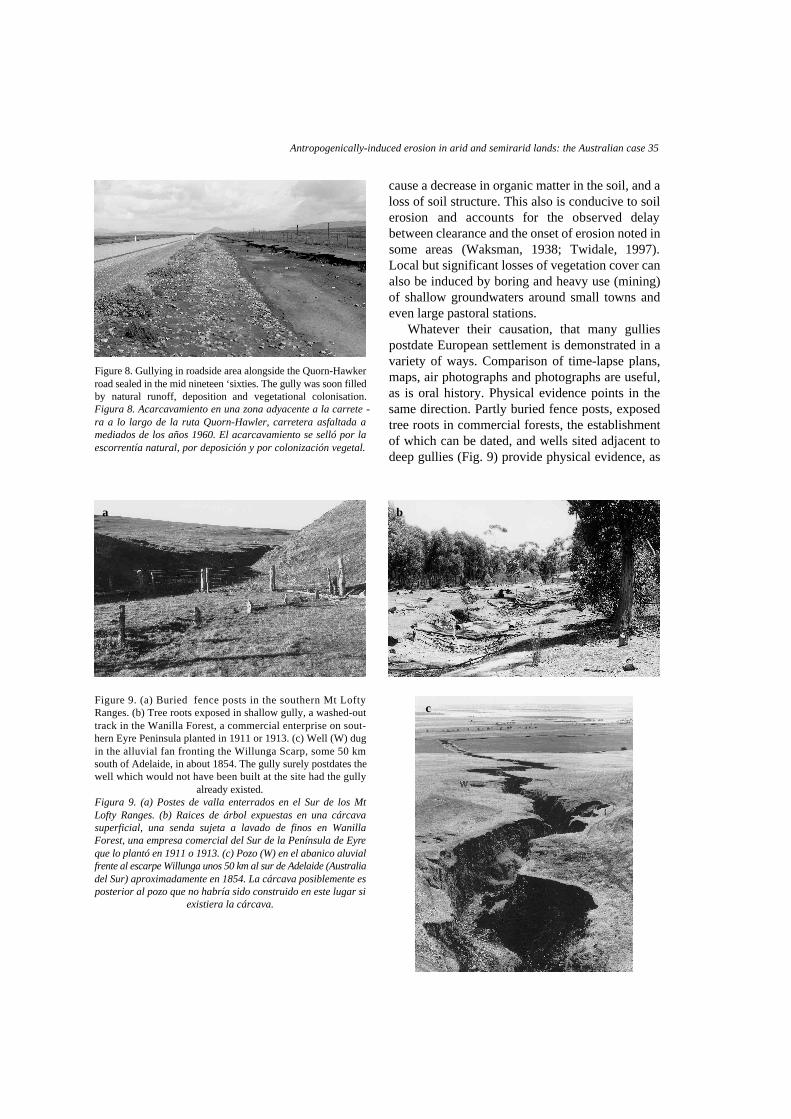
Whatever their causation, that many gulliespostdate European settlement is demonstrated in avariety of ways. Comparison of time-lapse plans,maps, air photographs and photographs are useful,as is oral history. Physical evidence points in thesame direction. Partly buried fence posts, exposedtree roots in commercial forests, the establishmentof which can be dated, and wells sited adjacent todeep gullies (Fig. 9) provide physical evidence, as
Figure 8. Gullying in roadside area alongside the Quorn-Hawkerroad sealed in the mid nineteen ‘sixties. The gully was soon filledby natural runoff, deposition and vegetational colonisation.Figura 8. Acarcavamiento en una zona adyacente a la carrete -ra a lo largo de la ruta Quorn-Hawler, carretera asfaltada amediados de los años 1960. El acarcavamiento se selló por laescorrentía natural, por deposición y por colonización vegetal.
Figure 9. (a) Buried fence posts in the southern Mt LoftyRanges. (b) Tree roots exposed in shallow gully, a washed-outtrack in the Wanilla Forest, a commercial enterprise on sout-hern Eyre Peninsula planted in 1911 or 1913. (c) Well (W) dugin the alluvial fan fronting the Willunga Scarp, some 50 kmsouth of Adelaide, in about 1854. The gully surely postdates thewell which would not have been built at the site had the gully
already existed.Figura 9. (a) Postes de valla enterrados en el Sur de los MtLofty Ranges. (b) Raices de árbol expuestas en una cárcavasuperficial, una senda sujeta a lavado de finos en WanillaForest, una empresa comercial del Sur de la Península de Eyreque lo plantó en 1911 o 1913. (c) Pozo (W) en el abanico aluvialf rente al escarpe Willunga unos 50 km al sur de Adelaide (Australiadel Sur) aproximadamente en 1854. La cárcava posiblemente esposterior al pozo que no habría sido construido en este lugar si
existiera la cárcava.
a b
c
do gullies developed along plough furrows (Fig. 4,and see below), for they all clearly postdate humanoccupation.
3.2. Arable and mixed farming
Many semiarid areas have been cleared and areutilised for agriculture. Huge areas of semiaridsouthern Australia are utilised for mixed farming.In particular, the huge wheat-sheep belt extendsfrom the Indian Ocean in the west to central NewSouth Wales and northwestern Victoria in the east,though interrupted by a sheep-only zone on theNullarbor Plain. The same factors as those whichapply in pastoral conditions are important alsohere. Clearance tends to be severe, for whereas pas-toralists tend to leave some trees to provide shadefor stock, such vegetational ‘islands’ interrupt thepattern and ease of cultivation. Deforestation isessentially complete except where special condi-tions and regulations apply. For instance, in manyparts of South Australia agriculture has extendedinto low and unreliable rainfall areas such as north-ern Eyre Peninsula and the northwestern MurrayBasin, which border the arid zone and which in theLate Quaternary were desert dunefields. Thoughgovernment regulations now require that the largerdunes remain in vegetation, paths, tracks or roadsdriven across such obstacles, as well as local exca-vations for building sand, are exploited by wind. Itis not uncommon for a crop to be ‘beheaded’ byblowing sand. In addition, most dust storms expe-
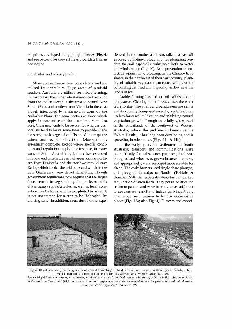
rienced in the southeast of Australia involve soilexposed by ill-timed ploughing, for ploughing ren-ders the soil especially vulnerable both to waterand wind erosion (Fig. 10). As to prevention or pro-tection against wind scouring, as the Chinese haveshown in the northwest of their vast country, plant-ing of suitable vegetation can retard wind erosionby binding the sand and impeding airflow near theland surface.
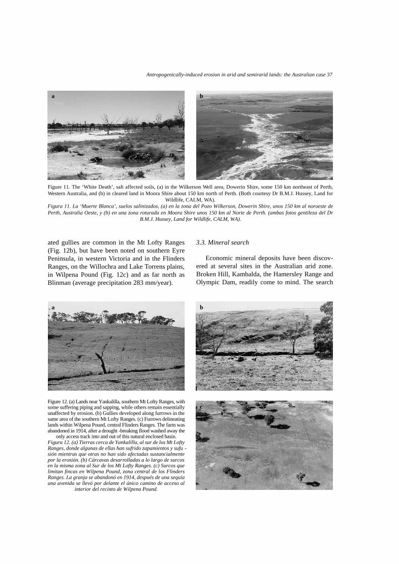
Arable farming has led to soil salinisation inmany areas. Clearing land of trees causes the watertable to rise. The shallow groundwaters are salineand this quality is imposed on soils, rendering themuseless for cereal cultivation and inhibiting naturalvegetation growth. Though especially widespreadin the wheatlands of the southwest of WesternAustralia, where the problem is known as the‘White Death’, it has long been developing and isspreading in other states (Figs. 11a & 11b).
In the early years of settlement in SouthAustralia, transport and communications werepoor. If only for subsistence purposes, land wasploughed and wheat was grown in areas that later,and appropriately, were adjudged more suitable forsheep. The early farmers used single share ploughs,and ploughed in strips or ‘lands’ ( Twidale &Bourne, 1978). An especially deep furrow markedthe junction of such lands. They persisted after thereturn to pasture and were in many areas sufficientto concentrate runoff and induce gullying. Pipinghas caused such erosion to be discontinuous inplaces (Fig. 12a; also Fig. 4). Furrows and associ-
36 C.R. Twidale (2004). Rev. C&G, 18 (3-4)
Figure 10. (a) Gate partly buried by sediment washed from ploughed field, west of Port Lincoln, southern Eyre Peninsula, 1960.(b) Wind-blown sand accumulated along a fence line, Corrigin area, Western Australia, 2001.
Figura 10. (a) Puerta enterrada parcialmente por el sedimento lavado desde el campo de labranza, al Oeste de Port Lincoln, al Sur dela Península de Eyre, 1960. (b) Acumulación de arena transportada por el viento acumulada a lo largo de una alambrada divisoria
en la zona de Corrigin, Australia Oeste, 2001.
a b
Antropogenically-induced erosion in arid and semirarid lands: the Australian case 37
ated gullies are common in the Mt Lofty Ranges(Fig. 12b), but have been noted on southern EyrePeninsula, in western Victoria and in the FlindersRanges, on the Willochra and Lake Torrens plains,in Wilpena Pound (Fig. 12c) and as far north asBlinman (average precipitation 283 mm/year).
3.3. Mineral search
Economic mineral deposits have been discov-ered at several sites in the Australian arid zone.Broken Hill, Kambalda, the Hamersley Range andOlympic Dam, readily come to mind. The search
Figure 11. The ‘White Death’, salt affected soils, (a) in the Wilkerson Well area, Dowerin Shire, some 150 km northeast of Perth,Western Australia, and (b) in cleared land in Moora Shire about 150 km north of Perth. (Both courtesy Dr B.M.J. Hussey, Land for
Wildlife, CALM, WA).Figura 11. La ‘Muerte Blanca’, suelos salinizados, (a) en la zona del Pozo Wilkerson, Dowerin Shire, unos 150 km al noroeste dePerth, Australia Oeste, y (b) en una zona roturada en Moora Shire unos 150 km al Norte de Perth. (ambas fotos gentileza del Dr
B.M.J. Hussey, Land for Wildlife, CALM, WA).
a b
Figure 12. (a) Lands near Yankalilla, southern Mt Lofty Ranges, withsome suffering piping and sapping, while others remain essentiallyu n a ffected by erosion. (b) Gullies developed along furrows in thesame area of the southern Mt Lofty Ranges. (c) Furrows delineatinglands within Wilpena Pound, central Flinders Ranges. The farm wasabandoned in 1914, after a drought -breaking flood washed away the
only access track into and out of this natural enclosed basin.Figura 12. (a) Tierras cerca de Yankalilla, al sur de los Mt LoftyRanges, donde algunas de ellas han sufrido zapamientos y sufu -sión mientras que otras no han sido afectadas sustancialmentepor la erosión. (b) Cárcavas desarrolladas a lo largo de surcosen la misma zona al Sur de los Mt Lofty Ranges. (c) Surcos quelimitan fincas en Wilpena Pound, zona central de los FlindersRanges. La granja se abandonó en 1914, después de una sequíauna avenida se llevó por delante el único camino de acceso al
interior del recinto de Wilpena Pound.
a b
c
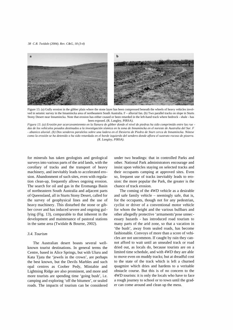
for minerals has taken geologists and geologicalsurveys into various parts of the arid lands, with thecorollary of tracks and the transport of heavymachinery, and inevitably leads to accelerated ero-sion. Abandonment of such sites, even with regula-tion clean-up, frequently allows ongoing erosion.The search for oil and gas in the Eromanga Basinof northeastern South Australia and adjacent partsof Queensland, all in Sturts Stony Desert, called forthe survey of geophysical lines and the use ofheavy machinery. This disturbed the stone or gib-ber cover and has induced severe and ongoing gul -lying (Fig. 13), comparable to that inherent in thedevelopment and maintenance of pastoral stationsin the same area (Twidale & Bourne, 2002).
3.4. Tourism
The Australian desert boasts several well-known tourist destinations. In general terms theCentre, based in Alice Springs, but with Uluru andKata Tjuta the ‘jewels in the crown’, are perhapsthe best known, but the Devils Marbles and suchopal centres as Coober Pedy, Mintabie andLightning Ridge are also prominent, and more andmore tourists are spending time ‘going bush’, i.e.camping and exploring ‘off the bitumen’, or sealedroads. The impacts of tourism can be considered
under two headings: that in controlled Parks andother. National Park administrators encourage andinsist upon vehicles staying on selected tracks andtheir occupants camping at approved sites. Evenso, frequent use of tracks inevitably leads to ero-sion: the more popular the Park, the greater is thechance of track erosion.
The coming of the 4WD vehicle as a desirableand safe family vehicle – seemingly safe, that is,for the occupants, though not for any pedestrian,cyclist or driver of a conventional motor vehiclefor whom the height and the various bullbars andother allegedly protective ‘armaments’pose unnec-essary hazards - has introduced road tourism tomany parts of the arid zone, so that a vacation in‘the bush’, away from sealed roads, has becomefashionable. Convoys of more than a score of vehi-cles are not uncommon. If caught by rain they can-not afford to wait until an unsealed track or roaddried out, as locals do, because tourists are on alimited time schedule, and with 4WD they are ableto move even on muddy tracks; but at dreadful costto the state of the track which is left a churnedquagmire which dries and hardens to a veritableobstacle course. But this is of no concern to the4WD tourists: it is only the locals who have to facea rough journey to school or to town until the grad-er can come around and clean up the mess.
38 C.R. Twidale (2004). Rev. C&G, 18 (3-4)
Figure 13. (a) Gully erosion in the gibber plain where the stone layer has been compressed beneath the wheels of heavy vehicles invol-ved in seismic survey in the Innamincka area of northeastern South Australia. F – alluvial fan. (b) Two parallel tracks on slope in SturtsStony Desert near Innamincka. Note that erosion has either ceased or been retarded in the left-hand track where bedrock - shale - has
been exposed. (R. Langley, PIRSA).Figura 13. (a) Erosión por acarcavamienmto en la llanura de gibber donde el nivel de piedras ha sido comprimido entre las ru e -das de los vehículos pesados destinados a la investigación sísmica en la zona de Innamincka en el noreste de Australia del Sur. F- abanico aluvial. (b) Dos senderos paralelos sobre una ladera en el Desierto de Piedra de Sturt cerca de Innamincka. Nótesecomo la erosión se ha detenido o ha sido re t a rdada en el borde izquierdo del sendero donde aflora el sustrato rocoso de pizarra.
(R. Langley, PIRSA).
a b

Antropogenically-induced erosion in arid and semirarid lands: the Australian case 39
Off-track use of 4WD vehicles is, however,much worse, for drivers tend to take their vehicleswherever the whim takes them, without regard tolong-term or even short-term impacts; and a singleimpression is enough to induce erosion, particular-ly as in arid and semiarid lands such random tracks,used only once, are known to last several years.(For example, tracks made in the Gawler Rangesby the explorers Eyre and Darke were noted up toalmost 20 years later by Hack and Warburton).Travelling over the stony desert later named afterhim, Sturt (1849, vol. I, p. 375) observed that hishorses and cart left a track that was visible onlyhere and there; nevertheless the impression theymade would have been enough to induce erosion.
O ffroad and offtrack driving is encouraged bydisgraceful advertising which frequently depicts4WD vehicles, with implicitly ‘macho’ d r i v e r s ,splashing through rocky creeks, or speeding overunsealed tracks and dunes, and along beaches,throwing plumes of dust and sand in their wake.One international manufacturer, whose cold weath-er experience should tell him how stupid it is,depicts the alleged fun and excitement to be hadtaking the vehicle in and out of the edge of the seawhile racing along a beach. Another advertisessedans standing on the bed of a salina (LakeGairdner) omitting to mention the effects of salt onbodywork and the fact that the salt crust can fail, asat least one owner of a partly submerged and neces-sarily abandoned 4WD knows to his cost! Or per-haps ‘salt-rusting’ and submerging vehicles insaline mud encourages sales?! Suffice it to say thaterosion by wind and water will still be effecting ero-sion and hence provide an enduring memento of fundrives long after the perpetrators have gone home.
4. Impacts
These various factors have led to extensive gul-lying and sheet erosion in the pastoral areas. Ofthese gullying is the more obvious and is difficultto counter in the short term, though only the uncon-solidated regolith is affected, for erosion ceasesonce lithified bedrock is exposed (Fig. 13b). Therebeing plenty of space, the usual solution for awashed-out track, which is eroded and reduced to aquagmire in the ‘wet’, is to move the track lateral-ly, and this has in places been done several times –
up to seven on a slope near Innamincka. Even so, itis easy to understand how the sunken roads ofwestern Europe, where lateral diversion wasrestricted by hedges and other field boundaries,were formed over the centuries. Sheet erosion iswidespread but not so obvious to the casual observ-er. Nevertheless it is the more important of the twotypes of accelerated erosion, for it involves the lossof the organically richer few centimetres of surfacesoil – the A-horizon (Figs. 5c & 7).
Scalding is a type of erosion involving theremoval of all vegetation and all topsoil – again, theA-horizon. These bare crusted areas are commonlyfound on saline soils which inhibit or kill many typesof vegetation. They are formed by either wind scour-ing or sheetwash. Sheetwash can be detected on sur-faces lacking drainage lines by indirect evidence.Surviving remnants of the A-horizon of soils arecommonly bounded by distinct low cliffs, but minia-ture flared slopes developed on surficial blocky cob-bles, as for example on the Brachina pediment, in thewestern piedmont of the Flinders Ranges, point to arecent lowering of soil level of some 7-8 cm.Exposed tree roots tell a similar story (Fig. 14).
Soil creep (or wash) is spectacularly evidencedat some sites (Figs. 15a & 15b) and though onlyinfrequently obvious is nevertheless commonplace.Mostly induced by earth movements and heavyrains, mass movements of material are developedin all climatic zones, including midlatitude arid andsemiarid lands (e.g. Shreve, 1968; Watson &Wright, 1969). Some lithologies are especially vul-
Figure 14. Evidence of lowering of soil level by almost a metre,Lake Torrens plains west of Hawker, South A u s t r a l i a .Figura 14. Pruebas de un rebajamiento del nivel del suelo decasi un metro en las llanauras del Lago Torrens al Oeste de
Hawker, Australia del Sur.
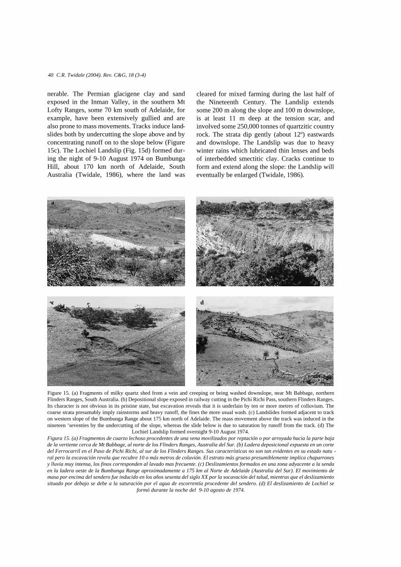
cleared for mixed farming during the last half ofthe Nineteenth Century. The Landslip extendssome 200 m along the slope and 100 m downslope,is at least 11 m deep at the tension scar, andinvolved some 250,000 tonnes of quartzitic countryrock. The strata dip gently (about 12º) eastwardsand downslope. The Landslip was due to heavywinter rains which lubricated thin lenses and bedsof interbedded smectitic clay. Cracks continue toform and extend along the slope: the Landslip willeventually be enlarged (Twidale, 1986).
nerable. The Permian glacigene clay and sandexposed in the Inman Valley, in the southern MtLofty Ranges, some 70 km south of Adelaide, forexample, have been extensively gullied and arealso prone to mass movements. Tracks induce land-slides both by undercutting the slope above and byconcentrating runoff on to the slope below (Figure15c). The Lochiel Landslip (Fig. 15d) formed dur-ing the night of 9-10 August 1974 on BumbungaHill, about 170 km north of Adelaide, SouthAustralia (Twidale, 1986), where the land was
40 C.R. Twidale (2004). Rev. C&G, 18 (3-4)
Figure 15. (a) Fragments of milky quartz shed from a vein and creeping or being washed downslope, near Mt Babbage, northernFlinders Ranges, South Australia. (b) Depositional slope exposed in railway cutting in the Pichi Richi Pass, southern Flinders Ranges.Its character is not obvious in its pristine state, but excavation reveals that it is underlain by ten or more metres of colluvium. Thecoarse strata presumably imply rainstorms and heavy runoff, the fines the more usual wash. (c) Landslides formed adjacent to trackon western slope of the Bumbunga Range about 175 km north of Adelaide. The mass movement above the track was induced in thenineteen ‘seventies by the undercutting of the slope, whereas the slide below is due to saturation by runoff from the track. (d) The
Lochiel Landslip formed overnight 9-10 August 1974.Figura 15. (a) Fragmentos de cuarzo lechoso procedentes de una vena movilizados por reptación o por arroyada hacia la parte bajade la vertiente cerca de Mt Babbage, al norte de los Flinders Ranges, Australia del Sur. (b) Ladera deposicional expuesta en un cortedel Ferrocarril en el Paso de Pichi Richi, al sur de los Flinders Ranges. Sus características no son tan evidentes en su estado natu -ral pero la excavación revela que recubre 10 o más metros de coluvión. El estrato más grueso presumiblemente implica chaparronesy lluvia muy intensa, los finos corresponden al lavado mas frecuente. (c) Deslizamientos formados en una zona adyacente a la sendaen la ladera oeste de la Bumbunga Range aproximadamente a 175 km al Norte de Adelaide (Australia del Sur). El movimiento demasa por encima del sendero fue inducido en los años sesenta del siglo XX por la socavación del talud, mientras que el deslizamientosituado por debajo se debe a la saturación por el agua de escorrentía procedente del sendero. (d) El deslizamiento de Lochiel se
formó durante la noche del 9-10 agosto de 1974.
a b
dc
Antropogenically-induced erosion in arid and semirarid lands: the Australian case 41
5. Repair and restoration
Turning to possible ameliorative practices,contour ploughing, introduced to prevent rapidr u n o ff, can fail and cause deep gullying. On theother hand, there is some evidence that if leftalone, gullies will fill themselves. They aredepressions and thus attract water and sediment.This process has filled roadside gullies developedafter the sealing of the Quorn-Hawker road acrossthe Willochra Plain (Fig. 8) in the southernFlinders Ranges in the mid ‘sixties, and is truealso of some of the gullies related to land clear-ance by whatever means in both the Flinders andMt Lofty ranges (e.g. Fig. 6). But unless stabilisedby vegetation, the unconsolidated fill is more sus-ceptible to subsequent erosion during and follow-ing heavy rains.
In the context of gullies, self-sealing is helpedif, as has frequently happened, coarse debris(concrete blocks, large rocks, old refrigerators,etc) is dumped in the gullies. Whatever themotive, such obstacles achieve the same end.Channel roughness is increased and streamvelocity and erosional potential are lowered( R u b e y, 1952). Given no further catastrophicrains and runoff, such gullies tend to build theirfloors and vegetation binds the sediment. But thistakes time and calls for good luck in the timing ofheavy rains.
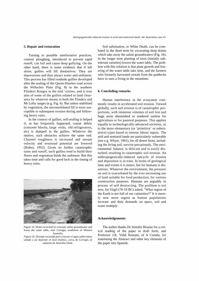
Soil salinisation, or White Death, can be com-bated in the short term by excavating deep drainswhich take away the saline groundwaters (Fig. 16).In the longer term planting of trees (initially salt-tolerant varieties) lowers the water table. The prob-lem with this solution is that plant growth and low-ering of the water table take time, and the farmerswho formerly harvested cereals from the paddockshave to earn a living in the meantime.
6. Concluding remarks
Human interference in the ecosystem com-monly results in accelerated soil erosion. Vi e w e dg l o b a l l y, such soil erosion is of catastrophic pro-portions, with immense volumes of soil lost andhuge areas diminished or rendered useless foragriculture or for pastoral purposes. This appliesequally to technologically-advanced societies, asto the more elementary (or ‘primitive’ or subsis-tence) types based in intense labour inputs. T h earid and semiarid lands are particularly vulnerable(see e.g. Whyte, 1961), for all desert biota, includ-ing the living soil, survive precariously. The envi-ronmental balance is delicate and is easily dis-turbed, resulting in catastrophic soil erosion. A nanthropogenically-induced epicycle of erosionand deposition is in train. In terms of geologicaltime and events it is minor, but for humans is dis-astrous. Whatever the environment, the pressureon soil is exacerbated by the ever-increasing useof land suitable for food production, for variousconstruction purposes. Humans are arguably inprocess of self destructing. The problem is notn e w, for Vi rgil (70-19 BC) asked, “What region ofthe Earth is not full of our calamities?” It is mere-ly now more urgent as human populationsincrease and their demands on space, soil andwater multiply.
Acknowledgements
The author thanks Dr Jennifer Bourne for a crit-ical reading of the paper in draft form, andProfessor J.R. Vidal Romani, of A Coruña, fortranslating the Abstract and other key elements ofthe paper into Spanish.
Figure 16. Drain excavated to evacuate saline groundwater andlower the water table, near Corrigin, southwest of Western
Australia.Figura 16. Drenaje excavado para evacuar el agua subterráneasalada y así deprimir el nivel freático, cerca de Corrigin, al
sudoeste de Australia Oeste.
References
McKnight, T.L. (1976). Friendly Vermin: a Survey of Feral Livestockin A u s t r a l i a. California University Press, Berkeley, 104 pp.
Meinig, D.W. (1962). On the Margins of the Good Earth. RandMcNally, Chicago, 231 pp.
Peel, R.F. (1941). Denudation landforms of the central LibyanDesert. Journal of Geomorphology, 4, 3-23.
Ratcliffe, F.N. (1936). Soil drift in the pastoral areas of SouthAustralia. CSIR Pamphlet, 64, 84 pp.
Ratcliffe, F.N. (1937). Further observations on soil erosion andsand drift, with special reference to southwest Queensland.CSIR Pamphlet, 70, 28 pp.
Ratcliffe, F.N. (1938). Flying Fox and Drifting Sand. Chatto &Windus, London, 341 pp.
Rubey, W.W. (1952). Geology and mineral resources of theHardin and Brussels quadrangles, Illinois. United StatesGeological Survey Professional Paper, 218, 170 pp.
Russell, R.J. (1936). The desert rainfall factor in denudation.Report of the 15th International Geological Congress, Part 2,337-372.
Shreve, R.L. (1968). The Blackhawk Landslide. GeologicalSociety of America Special Paper , 108, 47 pp.
Sturt, C. (1849). Narrative of an Expedition into CentralAustralia performed under the Authority of Her Majesty’s
Government during the years 1844, 5, and 6. 2 volumes,Boone, London.
Twidale, C.R. (1986). The Lochiel Landslip. A u s t r a l i a nGeographer, 17, 35-39.
Twidale, C.R. (1997). Some recently developed landforms: cli-matic implications. Geomorphology, 19, 349-365
Twidale, C.R. & Bourne, J.A. (1978). Distribution of relic‘ l a n d s ’ or strip fields in South Australia. A u s t r a l i a nGeographer, 14, 22-29.
Twidale, C.R. & Bourne, J.A. (2002). Sturts Stony Desert, cen-tral Australia. Erdkunde, 56, 401-418.
Waksman, S.A. (1938). Humus: Origin, Chemical Composition,and Importance in Nature. Williams & Wilkens, Baltimore,526 pp.
Watson, R.A. & Wright, H.E. (1969). The Saidmarreh landslide.Geological Society ofAmerica Special Paper, 123, 115-139.
Webb, R.H. (1983). Compaction of desert soils by off-roadvehicles. In: Environmental Effects of Off-Road Vehicles.Impacts and Management in Arid Regions. (R.H. Webb andH.G. Wilshire, eds.). Springer, New York, 51-79.
Whyte, R.O. (1961). Evolution of land use in south-westernAsia. In: A History of Land Use in Arid Regions. (L.D. Stamp,ed.). UNESCO, Paris, 57-118.
Recibido 21 de diciembre 2003Aceptado 10 de abril 2004
42 C.R. Twidale (2004). Rev. C&G, 18 (3-4)