Embed Size (px)
Citation preview

Retrospective GIS-Based Multi-Criteria Decision Analysis: A Case Study of California Waste Transfer Station Siting Decisions
John F. Cirucci, The Pennsylvania State University, Dept. of Geography, [email protected] Douglas A. Miller, The Pennsylvania State University, Dept. of Geography, [email protected] Justine I. Blanford, The Pennsylvania State University, Dept. of Geography, [email protected]
Abstract. Geographic information science (GIS) and multicriteria decision analysis (MCDA) disciplines combine to provide valuable insights which guide decision-makers evaluating complex spatial criteria and alternatives, especially when there are conflicting stakeholder values and objectives. Although GIS and MCDA methods have been integrated to support forward-looking decision analyses, there is also advantage to applying these methods retrospectively in order to decipher the factors that composed previous spatially-complex decisions. The objective of this study is to demonstrate a methodology which applies “retrospective GIS-based MCDA” to characterize decision-maker value preferences in past siting decisions without a priori knowledge of the decision-making process. As a representative case study, retrospective GIS-based MCDA is performed on municipal solid waste transfer station site decisions in Los Angeles County, California.
Potential attribute data were identified and compiled into a geographic information system. The attributes of actual facility sites and their surrounding vicinities were established as the presence case for a positive decision. This decision problem was structured considering two MCDA decision model types – value function using weighted linear combination and reference point. The attributes of historical site selections were decomposed and compared to unselected sites to identify attribute patterns. The value function MCDA model was parameterized using logistic regression to establish relative attribute weights which were applied to create a probability spatial distribution profile. The reference point MCDA rule model was parameterized contrasting attribute relative frequency Pareto between transfer station and general locations to create a satisfaction spatial distribution profile. These resulting models provide both relative rank and objective level of attributes represented in previous waste transfer station location decisions. The methodology is applicable to evaluation of spatial decisions in other domains, and can be extended to consider other MCDA decision models.
Proceedings of the International Symposium on Sustainable Systems and Technologies (ISSN 2329-9169) is published annually by the Sustainable Conoscente Network. Jun-Ki Choi and Annick Anctil, co-editors 2015. [email protected].
Copyright © 2015 by John Cirucci, Douglas Miller, Justine Blanford, Licensed under CC-BY 3.0.
Cite as: Retrospective GIS-Based Multi-Criteria Decision Analysis: A Case Study of California Waste Transfer
Station Siting Decisions. Proc. ISSST, Cirucci, J.F., Miller, D.A., Blanford, J.I. http://dx.doi.org/10.6084/m9.figshare.1512514 v3 (2015)

Retrospective GIS-Based Multi-Criteria Decision Analysis: A Case Study of California Waste Transfer Station Siting Decisions
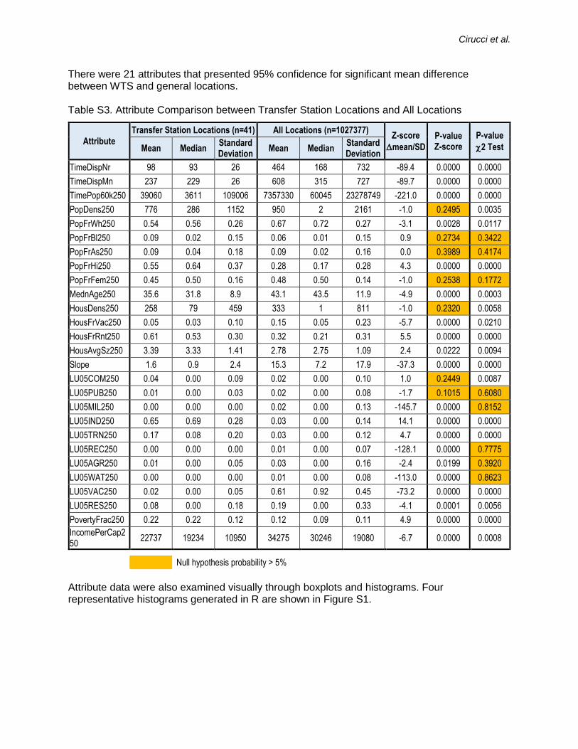
Introduction. Every day, we are constantly making simple decisions, considering many criteria. Usually the process is implicit and the decision maker is an individual. In contrast, “multicriteria decision analysis” (“MCDA”) describes a collection of formal approaches that can be used to make complex, high impact decisions with multiple stakeholders. The general stages of an MCDA process and two representative decision rule models are depicted in Figure 1. As part of problem structuring, criteria and alternatives are identified. In MCDA, criteria are defined as system attributes or objectives which fulfill a desired outcome. Alternatives are the options from which a final decision is selected. There may be a few alternatives, or an effectively infinite number such as with continuous surface site selection. Problem structuring also requires identification of stakeholders. A significant advantage of many MCDA methods is explicit quantification of stakeholder values. During the model building stage, decision rules are applied to evaluate criteria so the relative worth of possible alternatives can be characterized. Value measurement models entail assigning partial values to all criteria then aggregating these through various combination options to derive a comparative value for each alternative. Reference point models involve establishing a threshold, reference level for each criterion by which alternatives are successively filtered. There are many variants on these and other decision rule types. These two decision rule types were examined in this study. The information that the decision rule model yields is synthesized to establish a course of action (Belton & Stewart, 2002).
Figure 1. a) General MCDA Process b) Two Decision Rule Model Types
Many decisions require spatial consideration – criterion or alternative characteristics may comprise location and proximity. A geographic information system (GIS) can be used in multicriteria decision analysis to assist decision-makers with spatial decisions, and, in fact, GIS-based MCDA is an expanding field with increasing research and application interest. More than 800 peer-reviewed GIS MCDA articles were published between 1990 and 2010 with accelerating frequency covering a broad range of methods, decision problems and application domains (Malczewski & Rinner, 2015). Methodologies for GIS-based MCDA and MCDA, in general, deal entirely with a forward-looking view, resolving a current problem to achieve an improved future outcome. Alternatively, there could be significant information derived from past decisions that involved conflicting stakeholder objectives and complex evaluation of alternatives.
Hypothesis. Thus, could evidence on historical, third-party decisions be reverse-engineered to elicit information about the stakeholders’ values and the decision-making process?
In this study, geospatial statistical analyses were integrated with multiple criteria decision analysis methods to retrospectively examine prior location decisions which entailed multiple stakeholders with conflicting motivations and data uncertainty. An inverse problem approach was applied to evaluate possible criteria, develop value preference parameters and test different
Problem Structuring
Model Building
Information Synthesis
Problem
Identification
Action
Plan
1
2
3
4
5
Criteria
Alternatives
Uncertainties
Stakeholders
Environmental factors & constraints
DECISION RULES
• Criteria preferences
• Aggregation method
Criterion 2
partial value
Criterion 1
partial value
Criterion n
partial value
...
Alternative 1
Value
Criterion 2
partial value
Criterion 1
partial value
Criterion n
partial value
...
Alternative 2
Value
Criterion 2
partial value
Criterion 1
partial value
Criterion n
partial value
...
Alternative n
Value
.
.
.
Aggregator
Algorithm
highest ranked
criterion
Alternative
Alternative
Alternative
Alternative
Alternative
...
reference
level
Satisfied
Not
SatisfiedXnext ranked
criterion
Alternative
AlternativeXreference
level
lowest ranked
criterion
Alternative
AlternativeXreference
level
...
Alternative
Value Preference Reference Point

Cirucci et al.
MCDA decision rule models without explicit information about stakeholders’ values or decision processes. The objectives were to (1) create a probabilistic model for prediction of future related decision outcomes; (2) provide insights in decision-maker strategies; and (3) develop and demonstrate a new methodology applicable to other spatial decision domains. The site selection of municipal solid waste transfer stations (WTS) in Los Angeles County, California, was selected as a representative case study.
Investigative Method. A WTS is a facility for solid waste to be temporarily unloaded from collection vehicles and stored for a short duration, so that it can be reloaded onto large load vehicles for transportation to a final disposal facility (Environmental Protection Agency, 2002). Siting a WTS is a classic NIMBY (“not in my backyard”) scenario since residents and business owners will not want to be proximate to the site. The decision maker for siting may be a municipality or commercial entity but there are many stakeholders influencing this decision. Transport distance and cost are important siting considerations. However, there are many other criteria which may be evaluated in decision analysis – community concern over noise, odor, and traffic, land use restrictions, population density and growth rate, WTS capacity and technologies. Some important social characteristics such as local population ethnic and racial demographics may not be explicitly incorporated into decision processes but may be implicitly correlated to outcomes, so these must also be considered. Previous studies identified WTS clustering in low income, non-white communities (Environmental Protection Agency, 2000). There are inevitably other site-specific criteria such as local political objectives and site history which are difficult to broadly incorporate into a general, county-wide study. For this study the data collection strategy was to collect readily available, public information across a breadth of categories. These data were selected to encompass EPA WTS best practice guidance as well as some exploratory, implicit criteria including racial demographics and housing characteristics. The effectiveness in these data describing actual results will indicate the extent of deficiencies from missing information and establish a baseline against which future criteria can be evaluated. Since there are a large number of zoning classes and special zoning areas in LA County, zoning was generally considered as agglomerated land use type based on the database created by the Southern California Association of Governments (2015). The study data consist of WTS location coordinates, waste type, capacity, facility land area, landfill disposal site coordinates, the complete county roadway network, land use classification, elevation, population, demographics (racial, ethnic, gender, age), housing characteristics, and income level. The complete list of study criteria is included in the Supplementary Material, Table S1.
Data Preparation. This study focused on WTS operating between 2000 - 2015 applying 2005 land use classification and 2010 Census demographic data. The Solid Waste Information System (SWIS), maintained by the California Department of Resources Recycling and Recovery, served as the primary source of data on WTS and disposal facilities in California (California Department of Resources Recycling and Recovery, 2014). Effective after 1994, the only WTS in California that require full permits are those with greater than 100 tons per day capacity, designated as “Large Volume Transfer Stations.” For the purpose of this study, 41 large volume WTS operating in Los Angeles County (contiguous, excluding islands) between 2000 and 2015 were analyzed.
Demographic data and associated TIGER/Line shapefile geographic boundaries were obtained from the U.S. Census Bureau database at the census block level for 2010 and included age, gender, race, ethnicity and household characteristics (family size, ownership type. Income and poverty level were acquired from the U.S. American Community Survey 5-year estimates available at the block group level for Los Angeles County (United States Census Bureau, 2015). Roads were also obtained as TIGER/Line shapefiles from the US Census Bureau. Slope data

Retrospective GIS-Based Multi-Criteria Decision Analysis: A Case Study of California Waste Transfer Station Siting Decisions
were calculated using the 10-foot Digital Elevation Model (DEM) obtained from the Los Angeles Regional Imagery Acquisition Consortium (Los Angeles County, 2015). Land use data for 2009 were obtained from SCAG (Southern California Association of Governments, 2015).
Since transportation costs are important in the optimization of site selection (Environmental Protection Agency, 2002), this was accounted for by calculating travel time from each cell to all disposal locations within the LA County. The travel time to residents was estimated based on the road distance to serve a population of 60,000 people. Road types not suitable for transfer vehicles, such as bike paths were removed; the remaining road types were assigned a relative transportation cost represented as estimated travel time (Table S2 Supplementary).
All data were spatially converted and assigned to 1 hectare area cells. The contiguous LA County land area is over 1 million hectares. These cells were established as the set of possible site alternatives. The median land area of a transfer station is 2.5 acres in LA County which is approximately consistent with this study area cell resolution. Demographic data (e.g. population, housing, income) and land use at an immediate cell location may not be indicative of the vicinity characteristics. Therefore, the data for the surrounding “neighborhood” (within a radius of 0.25 km) was obtained and the mean value was assigned to each center cell. All data were extracted to tabular format for subsequent statistical analyses.
Analysis. Data analyses were performed using ArcGIS 10.2, R version 3.0.2 (R Core Team, 2013) and Microsoft Excel. A preliminary evaluation of the spatial distribution of WTS in LA County was performed in ArcGIS to identify the extent of non-random distribution and clustering. All attribute data were mapped for visual examination and qualitative pattern identification. Tabular attribute data was examined as boxplots, histograms and density plots. Side-by-side comparison was made for WTS locations versus general locations considering general statistical characteristics – range, mean, median, skew, standard deviation. Mean difference and Chi-squared test probabilities were computed. Two general MCDA decision rule models were evaluated using this dataset: Value Function type and Reference Point type.
Value Function Decision Model. For the value function model form, a simple weighted linear combination was considered. Data were regressed to establish attribute weights which provide a sum of products value for any given location alternative. Higher values should correspond to more preferred locations. The dependent variable is the presence indication of a transfer station at a given location, represented as 1 or 0, for present or not present, respectively. Since this outcome is binary, a logistic regression was performed. Attributes were fitted to the model form:
ytransfer = 1 / [1+ exp-(c0 +c1x1 + c2 x2 +…)]
Where, ytransfer = probability of the WTS presence, c0 = intercept, ci = attribute i weight xi = attribute i value.
Logistic regression model goodness-of-fit was evaluated considering changes in residual deviance versus null deviance. Relative comparisons of model forms were performed using deviances (log likelihood ratios) and Akaike information criteria (AIC). Attribute significance and collinearity were evaluated considering P-value, variance inflation factor (VIF) and condition indices (Hosmer, Lemeshow, & Sturdivant, 2013). AIC represents a trade-off between model fit and collinearity, and was used as the final optimization parameter. Individual attributes were iteratively removed based on lowest rank confidence of statistical mean difference between WTS and general locations, evidence of collinearity, and stepwise improvement in fit. Attribute

Cirucci et al.
combinations were evaluated and removed iteratively to progressively improve model fit and reduce multicollinearity. Linear combination of the sum product of weights and attribute values provide the logit value which was then transformed into a WTS logistic probability assigned to each cell. This table of probabilities retaining its spatial georeferences was imported back into ArcGIS to produce a WTS probability distribution map for LA County.
Reference Point Decision Model. The reference point decision rule model required the identification of significant maximum or minimum attribute thresholds. These were fitted by comparison of the attribute ranges and distribution profiles of actual WTS locations versus general locations. For each attribute, relative frequency (frequency/total) Pareto plots of WTS locations and general locations were created using the 41 WTS attribute values as bin increments. From these, the WTS:general relative frequency ratio was computed as a function of attribute value. Ratios greater than one imply that an attribute has a negative impact – that is, the frequency is increasing faster for WTS locations than for general locations over an attribute’s range. The opposite holds true for relative frequency ratios less than one. These are consistent with the mean difference analyses. Potential attribute reference points are indicated when there is a discontinuity or change in slope toward unity for these ratios. The reference point is a maximum threshold for ratios > 1 and a minimum threshold for ratios < 1. Reference points are not necessarily indicated for all attributes and some threshold indications were indistinct. For this study, obvious reference points were classified as “tier 1.” Weak reference points – defined as those which occurred when WTS relative frequency was less than 50% or when there was variability in the slope change – were classified as “tier 2.” These reference points were applied to classify attributes for all cells in the full dataset. In ArcGIS the individual attribute raster layers were reclassified from a value range to a binary indication of a reference point satisfaction (1= satisfied, 0=not satisfied). These individual attribute, binary raster layers were then processed to three different spatial distributions:
Product of all tier 1 binary reference point raster layers
Product of all tier 1 and 2 binary reference point raster layers
Sum of all tier 1 and 2 binary reference point raster layers
The two product combinations represent a conventional reference point decision rule resulting in a binary outcome for WTS satisfaction. The combined tier 1 and 2 rasters is most restrictive. The sum combination is a non-conventional reference point decision rule but provides a satisfaction gradient.
The value measurement probability results and reference point satisfaction results were mapped across LA County to provide a visualization of their distributions and comparative responses.
Results. Spatial distribution analysis of the active “large volume” WTS revealed a non-random distribution within LA County with an average mean distance of 3.1 km between stations versus a random distributed distance of 4.6 km. A low p-value (0.000084) and large negative z-score (-3.933) indicated low probability of random distribution and an observed mean distance between stations at about 2 standard deviations below a random distribution level. This was expected since WTS were seen to be clustered in proximity to the higher population density areas. Statistical comparison of attributes for WTS locations versus general locations indicate >95% confidence of significant mean difference for 19 of the 27 attributes (SupplementalInformation Table S3).
The retrospective value measurement logistic regression initially fit all attributes (27) as a baseline giving expectedly poor fit. Following 17 model improvement iterations, the final form

Retrospective GIS-Based Multi-Criteria Decision Analysis: A Case Study of California Waste Transfer Station Siting Decisions
was resolved comprising 11 attributes with significant, non-collinear model contribution. The value measurement probability distribution and normalized attribute weights are shown in Figure 2. Transportation times which directly impact WTS operating economics dominate the model fit.However, 6 demographic/social attributes significantly and independently impact WTSprobability. This does not directly implicate causality in the decision process but these attributesare not collinear with other study attributes. The absolute value preference probabilities arequite low, less than 0.02. This is expected since there is a small, discrete number of WTSrequired across the county yielding a randomly distributed probability of only 0.00004.
Figure 2. Normalized Attribute Weights and Value Measurement Probability Distribution
Retrospective reference point evaluation yielded 7 “tier 1” attributes and 4 “tier 2” attributes. 8 of these attributes were consistent with the value measurement results. The resulting satisfaction distributions for the three alternate reference point treatments are shown in Figure 3. Tier 1 and tier 1&2 products satisfied only 52% and 39% of actual WTS locations, respectively. However, these satisfaction frequencies were much higher than general locations, at 9% and 3%.
a) Tier 1 Product Layer b) Tier 1 & 2 Product Layer c) Tier 1 & 2 Sum LayerFigure 3. Reference Point Satisfaction Distribution for Los Angeles County WTS
Discussion. Retrospective value measurement analysis provided a well-fit probabilistic model predicting greater than 40 times mean higher probability for actual WTS site locations, and confirming the significance of transportation economic contribution while also indicating social demographic bias in decision outcomes. Retrospective reference point satisfaction was a
1
0.34
0.0890.068 0.052 0.043
0.024 0.018 0.017 0.012 0.0085
NEGATIVE
POSITIVE
Mean
Probability
Standard
Deviation
WTS Locations 0.0019 0.0015
All Locations 0.000044 0.00031

Cirucci et al.
simpler, non-regression method. Since the product aggregation of reference points is a restrictive filtration, the proportion of satisfactory sites becomes small as the number of attributes increases, so this approach might be best suited for decisions with a limited number of well-defined attributes. Both methods yielded practical and reasonably consistent results. In addition to further enhancement on these retrospective methods, useful future research should explore other MCDA methods such as outranking and the analytical hierarchy process.
Retrospective GIS-based MCDA can be applied to improve future decision analyses by providing explicit information about related past decisions, perhaps even revealing unintended and undesirable criteria correlation. It may also serve as an investigative tool to reveal external party strategies in commercial competitive analyses or military intelligence.

Retrospective GIS-Based Multi-Criteria Decision Analysis: A Case Study of California Waste Transfer Station Siting Decisions
Acknowledgments. This study was not funded.
References. Belton, V., & Stewart, T. (2002). Multiple criteria decision analysis: an integrated
approach. Kluwer. California Department of Resources Recycling and Recovery. (2014, November 12).
Solid Waste Information System (SWIS). Retrieved from CalRecyle: http://www.calrecycle.ca.gov/SWFacilities/Directory/Default.htm
Department of Regional Planning, County of Los Angeles. (2015, March). Plans & Ordinances. Retrieved from Department of Regional Planning: http://planning.lacounty.gov/plans/adopted
Environmental Protection Agency. (2000). A regulatory strategy for siting and operating waste transfer stations.
Environmental Protection Agency. (2002). Waste transfer stations: a manual for decision-making.
Los Angeles County. (2015, March). 2006 10-foot Digital Elevation Model (DEM) – LAR-IAC – Public Domain. Retrieved from Los Angeles County GIS Data Portal: http://egis3.lacounty.gov/dataportal/2011/01/26/2006-10-foot-digital-elevation-model-dem-public-domain/
Malczewski, J., & Rinner, C. (2015). Multicriteria Decision Analysis in Geographic Information Science. New York: Springer.
R Core Team. (2013). R: A language and environment for statistical. Retrieved from R Foundation for Statistical Computing, Vienna, Austria: http://www.R-project.org/
Southern California Association of Governments. (2015, March). GIS Library. Retrieved from GIS and Data Services: http://gisdata.scag.ca.gov/Pages/GIS-Library.aspx
United States Census Bureau. (2015, April). American Community Survey. Retrieved from US Census: http://www.census.gov/acs/www/data_documentation/data_via_ftp/
United States Census Bureau. (2015, March). TIGER Products. Retrieved from http://www.census.gov/geo/maps-data/data/tiger.html

Supplementary Information
Retrospective GIS-Based Multi-Criteria Decision Analysis: A Case Study of California Waste Transfer Station Siting Decisions
John F. Cirucci The Pennsylvania State University, [email protected] Douglas A. Miller The Pennsylvania State University, [email protected] Justine I. Blanford The Pennsylvania State University, [email protected]
Attributes The attribute criteria for which decision rules were evaluated are listed in Table S1.
Table S1. Final Attribute Data Evaluated in Decision Rule Models Field Name Description Type Category OBJECTID feature identification ordinal identifier Transfer2015 transfer station present (1,0) ordinal classifier Disposal2010 disposal facility present (1,0) ordinal classifier LandUse05 SCAG land use aggregate code at location nominal classifier TimeDispNr Time Distance to nearest disposal facility ratio attribute - distance TimeDispMn Mean Time Distance to all disposal facility ratio attribute - distance TimePop60k250 Time (Cost Distance) to nearest 60000 population ratio attribute - distance PopDens250 Population near (population per km2) ratio attribute - demographic PopFrWh250 Population fraction White at radius near ratio attribute - demographic PopFrBl250 Population fraction Black at radius near ratio attribute - demographic PopFrAs250 Population fraction Asian at radius near ratio attribute - demographic PopFrHi250 Population fraction Hispanic/Latino origin near ratio attribute - demographic PopFrFem250 Population over 20 years old fraction female near ratio attribute - demographic MednAge250 Median age near ratio attribute - demographic HousDens250 Housing units near (housing units per km2) ratio attribute - housing HousFrVac250 Housing units fraction vacant near ratio attribute - housing HousFrRnt250 Housing units occupied fraction rented near ratio attribute - housing HousAvgSz250 Average household size of occupied housing units near ratio attribute - housing Slope Percent slope ratio attribute - terrain LU05COM250 Fraction commercial land use near ratio attribute - land use LU05PUB250 Fraction public land use near ratio attribute - land use LU05MIL250 Fraction military land use near ratio attribute - land use LU05IND250 Fraction industrial land use near ratio attribute - land use LU05TRN250 Fraction transportation and utility land use near ratio attribute - land use LU05REC250 Fraction recreational land use near ratio attribute - land use LU05AGR250 Fraction agricultural land use near ratio attribute - land use LU05WAT250 Fraction water land use near ratio attribute - land use LU05VAC250 Fraction vacant land use near ratio attribute - land use LU05RES250 Fraction residential land use near ratio attribute - land use PovertyFrac250 Fraction individuals below poverty level near ratio attribute - affluence IncomePerCap250 Income per capita near ratio attribute - affluence
Travel Time Estimation Road data acquired as MAF/TIGER shapefiles included class codes. These were aggregated and assigned cost factors as shown in Table S2. A nominal speed limit was applied to these road types. An integer value cost factor was set, inversely proportional to the nominal road speed. Travel time was approximated from the cost factor as given in Equation S1.
𝑡𝑡𝑟𝑎𝑣𝑒𝑙, ℎ =𝑑𝑟𝑜𝑎𝑑 𝑐𝑜𝑠𝑡,𝑐𝑒𝑙𝑙
3 𝑐𝑜𝑠𝑡 𝑓𝑎𝑐𝑡𝑜𝑟×60𝑚𝑖
ℎ×1.61
𝑘𝑚
𝑚𝑖 ×10
𝑐𝑒𝑙𝑙
𝑘𝑚
=𝑑𝑟𝑜𝑎𝑑 𝑐𝑜𝑠𝑡,𝑐𝑒𝑙𝑙
2900 𝑐𝑒𝑙𝑙 ℎ⁄(Equation S1)
Allocation to each waste transfer station was made on the basis of population, not land area. Municipal solid waste generation per capita has been relatively flat since 1990 but recycle and compost recovery has been increasing so that net disposal has fallen from 1.7 to 1.3 kg per

Retrospective GIS-Based Multi-Criteria Decision Analysis: A Case Study of California Waste Transfer Station Siting Decisions
person from 1990 to 2012 (Environmental Protection Agency, 2014). On the basis of 1.5 kg per person, a California “large volume” transfer station operating at the minimum permit capacity of 100 tons per day would serve about 60,000 residents. This was used as the reference population level for any potential transfer station location to determine an impact radius as Euclidean distance and travel time based on road network. For consideration of the transportation time between population locations and potential WTS locations, both population density and transportation cost factor were taken together. A representative criteria, t60kPop was established to serve as a surrogate value for transportation time to serve 60,000 individuals as given in Equation S2. This was first established for each cell then averaged for the surrounding neighborhood within a radius of 0.25 km.
𝑡60𝑘𝑃𝑜𝑝, ℎ = (𝑑𝑟𝑜𝑎𝑑 𝑐𝑜𝑠𝑡,𝑐𝑒𝑙𝑙
2900 𝑐𝑒𝑙𝑙 ℎ⁄) × (
60000 𝑖𝑛𝑑𝑖𝑣𝑖𝑑𝑢𝑎𝑙𝑠
𝜌𝑝𝑜𝑝𝑢𝑙𝑎𝑡𝑖𝑜𝑛,𝑐𝑒𝑙𝑙−1) (Equation S2)
Table S2. Relative Roadway Cost Factors Based on MAF/TIGER Feature Class Codes
Preliminary Summary Statistics Summary statistics for attribute data including comparison of WTS and general locations is shown in Table S3. The mean difference Z-score was calculated per equation S3. This is a dimensionless difference between WTS and general attribute values normalized based on their standard deviations. An associated p-value represents the probability that there is no significant mean difference (null hypothesis). Hence a p-value less than 0.05 indicates a 95% confidence the difference of the means is significant. However, most of these attribute data were not normally distributed causing skew in the Z-score. Therefore, a Chi-squared p-value was also determined. The Chi-square test was applied to attribute frequency divided into bins corresponding to the general data quartile breaks.
𝑍∆𝑚𝑒𝑎𝑛 =(𝜇𝑤𝑡𝑠 − 𝜇𝑎𝑙𝑙)
√𝜎𝑤𝑡𝑠
2
𝑁𝑤𝑡𝑠+
𝜎𝑎𝑙𝑙2
𝑁𝑎𝑙𝑙
⁄(Equation S3)
Where
𝑤𝑡𝑠 = waste transfer station location attribute 𝑎𝑙𝑙 = general location attribute
𝜇 = attribute mean 𝜎 = standard deviation 𝑁 = count
MTFCC Feature Class Nominal Speed Limit
Cost Factor
S1100 Primary Road 60 3
S1200 Secondary Road 45 4
S1400 Local Neighborhood Road, Rural Road, City Street 15 12
S1500 S1630 S1640 S1730 S1740
Vehicular Trail (4WD) Ramp Service Drive usually along a limited access highway Alley Private Road for service vehicles
5 36
Null No road -- 360
Cirucci et al.
There were 21 attributes that presented 95% confidence for significant mean difference between WTS and general locations.
Table S3. Attribute Comparison between Transfer Station Locations and All Locations
Attribute
Transfer Station Locations (n=41) All Locations (n=1027377) Z-score
mean/SD
P-valueZ-score
P-value
2 TestMean Median Standard Deviation
Mean Median Standard Deviation
TimeDispNr 98 93 26 464 168 732 -89.4 0.0000 0.0000
TimeDispMn 237 229 26 608 315 727 -89.7 0.0000 0.0000
TimePop60k250 39060 3611 109006 7357330 60045 23278749 -221.0 0.0000 0.0000
PopDens250 776 286 1152 950 2 2161 -1.0 0.2495 0.0035
PopFrWh250 0.54 0.56 0.26 0.67 0.72 0.27 -3.1 0.0028 0.0117
PopFrBl250 0.09 0.02 0.15 0.06 0.01 0.15 0.9 0.2734 0.3422
PopFrAs250 0.09 0.04 0.18 0.09 0.02 0.16 0.0 0.3989 0.4174
PopFrHi250 0.55 0.64 0.37 0.28 0.17 0.28 4.3 0.0000 0.0000
PopFrFem250 0.45 0.50 0.16 0.48 0.50 0.14 -1.0 0.2538 0.1772
MednAge250 35.6 31.8 8.9 43.1 43.5 11.9 -4.9 0.0000 0.0003
HousDens250 258 79 459 333 1 811 -1.0 0.2320 0.0058
HousFrVac250 0.05 0.03 0.10 0.15 0.05 0.23 -5.7 0.0000 0.0210
HousFrRnt250 0.61 0.53 0.30 0.32 0.21 0.31 5.5 0.0000 0.0000
HousAvgSz250 3.39 3.33 1.41 2.78 2.75 1.09 2.4 0.0222 0.0094
Slope 1.6 0.9 2.4 15.3 7.2 17.9 -37.3 0.0000 0.0000
LU05COM250 0.04 0.00 0.09 0.02 0.00 0.10 1.0 0.2449 0.0087
LU05PUB250 0.01 0.00 0.03 0.02 0.00 0.08 -1.7 0.1015 0.6080
LU05MIL250 0.00 0.00 0.00 0.02 0.00 0.13 -145.7 0.0000 0.8152
LU05IND250 0.65 0.69 0.28 0.03 0.00 0.14 14.1 0.0000 0.0000
LU05TRN250 0.17 0.08 0.20 0.03 0.00 0.12 4.7 0.0000 0.0000
LU05REC250 0.00 0.00 0.00 0.01 0.00 0.07 -128.1 0.0000 0.7775
LU05AGR250 0.01 0.00 0.05 0.03 0.00 0.16 -2.4 0.0199 0.3920
LU05WAT250 0.00 0.00 0.00 0.01 0.00 0.08 -113.0 0.0000 0.8623
LU05VAC250 0.02 0.00 0.05 0.61 0.92 0.45 -73.2 0.0000 0.0000
LU05RES250 0.08 0.00 0.18 0.19 0.00 0.33 -4.1 0.0001 0.0056
PovertyFrac250 0.22 0.22 0.12 0.12 0.09 0.11 4.9 0.0000 0.0000
IncomePerCap250
22737 19234 10950 34275 30246 19080 -6.7 0.0000 0.0008
Null hypothesis probability > 5%
Attribute data were also examined visually through boxplots and histograms. Four representative histograms generated in R are shown in Figure S1.

Retrospective GIS-Based Multi-Criteria Decision Analysis: A Case Study of California Waste Transfer Station Siting Decisions
a) Mean Travel Time to All Disposal Facilities b) Travel Time to 60000 Residents
c) Population Fraction White (within 0.25 km) d) Population Fraction Hispanic (within 0.25 km)
Figure S1. Boxplot Comparison between WTS Locations and General Locations in LA County
Value Measurement Decision Rule The logistic regression performed to determine value measurement attribute coefficients proceeded through 17 iterations with the goal to attain goodness of fit while minimizing multicollinearity between attributes. The progression of these iterations is summarized in Table S4.
The final iteration resulted in coefficients that were then applied in the logistic form to derive a WTS probability for each cell in the study area. A small scale map of this probability distribution covering the City of Los Angeles is depicted in Figure S2 showing good correspondence with all current WTS locations.

Table S4. Value Measurement Logistic Regression Iteration Log
RUN 0 1 2 3 4 5 6 7 8 9 10 11 12 13 14 15 16 17
Dresid 912.6 486.7 490.9 493.2 516.4 516.5 490.6 503.4 490.7 490.7 490.7 490.7 490.8 490.9 490.8 490.9 518.3 491.2
Dnull 912.6 684.4 684.4 684.5 684.5 684.5 684.4 684.4 684.4 684.4 684.4 684.4 684.4 684.4 684.4 684.4 724.9 684.4
R2L 0.000 0.289 0.283 0.279 0.246 0.245 0.283 0.264 0.283 0.283 0.283 0.283 0.283 0.283 0.283 0.283 0.285 0.282
AIC 914.57 542.70 530.90 527.20 542.40 540.50 530.58 539.37 528.65 526.66 524.70 522.73 520.77 520.87 518.79 516.89 542.34 515.18
Paic 0.0000 0.0000 0.0004 0.0025 0.0000 0.0000 0.0005 0.0000 0.0012 0.0032 0.0086 0.0229 0.0611 0.0581 0.1645 0.4253 0.0000 1.0000
signif var 0 0 2 2 1 1 2 2 2 2 2 2 2 2 2 2 2 2
VIF>7.5 0 5 5 2 0 0 3 0 1 0 0 0 0 0 0 0 0 0
COEFFICIENTS
Intercept -10.13 -11.01 -8.87 -9.81 -8.28 -8.40 -10.75 -6.62 -10.70 -10.56 -10.64 -10.82 -10.86 -10.96 -10.82 -10.91 -9.68 -11.27
TimeDispNr 0.00E+00 1.29E-02 9.95E-03 0.00E+00 -7.78E-03 0.00E+00 0.00E+00 0.00E+00 0.00E+00 0.00E+00 0.00E+00 0.00E+00 0.00E+00 0.00E+00 0.00E+00 0.00E+00 0.00E+00 0.00E+00
TimeDispMn 0.00E+00 -1.86E-02 -1.48E-02 -5.96E-03 -1.74E-06 -7.90E-03 -5.73E-03 -7.91E-03 -5.72E-03 -5.75E-03 -5.89E-03 -5.95E-03 -5.96E-03 -5.95E-03 -6.00E-03 -5.98E-03 -6.61E-03 -5.64E-03
TimePop60k250 0.00E+00 -1.69E-06 -1.47E-06 -1.54E-06 0.00E+00 -1.70E-06 -1.45E-06 -1.62E-06 -1.47E-06 -1.47E-06 -1.49E-06 -1.48E-06 -1.47E-06 -1.45E-06 -1.47E-06 -1.45E-06 -1.32E-06 -1.39E-06
PopDens250 0.00E+00 -1.54E-04 -1.64E-04 0.00E+00 0.00E+00 0.00E+00 -1.61E-04 -1.53E-04 -8.67E-05 -8.17E-05 -7.04E-05 -6.96E-05 -6.95E-05 -7.20E-05 -7.09E-05 -7.40E-05 -6.52E-05 0.00E+00
PopFrWh250 0.000 -0.096 0.006 -0.080 -0.301 -0.263 0.000 0.000 0.000 0.000 0.000 0.000 0.000 0.035 0.000 0.000 0.000 0.000
PopFrBl250 0.000 -0.463 0.000 0.000 0.000 0.000 -0.353 -0.309 -0.367 -0.370 -0.364 -0.363 -0.380 0.000 -0.377 0.000 0.000 0.000
PopFrAs250 0.0000 0.0470 0.0000 0.0000 0.0000 0.0000 0.0000 0.0000 0.0000 0.0000 0.0000 0.0000 0.0000 0.0000 0.0000 0.0000 0.0000 0.0000
PopFrHi250 0.000 0.413 0.548 0.579 0.896 0.814 0.412 0.577 0.383 0.383 0.390 0.354 0.361 0.459 0.359 0.462 0.134 0.450
PopFrFem250 0.00 1.12 0.00 0.00 0.00 0.00 1.05 0.81 1.04 1.04 1.05 1.06 1.10 1.11 1.11 1.11 0.23 1.11
MednAge250 0.0000 -0.0194 -0.0206 -0.0180 0.0000 0.0000 -0.0194 -0.0186 -0.0195 -0.0194 -0.0193 -0.0172 -0.0172 -0.0171 -0.0172 -0.0168 -0.0270 -0.0161
HousDens250 0.00E+00 2.49E-04 2.26E-04 -7.30E-05 -7.54E-04 -7.49E-04 2.19E-04 0.00E+00 0.00E+00 0.00E+00 0.00E+00 0.00E+00 0.00E+00 0.00E+00 0.00E+00 0.00E+00 0.00E+00 0.00E+00
HousFrVac250 0.000 -0.586 -0.841 -0.475 -0.379 -0.275 -0.533 -0.616 -0.471 -0.478 -0.520 -0.432 0.000 0.000 0.000 0.000 0.000 0.000
HousFrRnt250 0.000 0.243 0.149 0.343 0.942 0.952 0.273 0.365 0.288 0.281 0.273 0.294 0.301 0.307 0.312 0.318 0.000 0.275
HousAvgSz250 0.0000 -0.0416 -0.0377 -0.0413 -0.0419 0.0000 -0.0258 -0.0518 -0.0345 -0.0339 -0.0334 0.0000 0.0000 0.0000 0.0000 0.0000 0.0000 0.0000
Slope 0.0000 -0.0575 -0.0596 -0.0631 -0.0822 -0.0822 -0.0605 -0.0521 -0.0607 -0.0606 -0.0641 -0.0638 -0.0636 -0.0624 -0.0645 -0.0631 -0.0674 -0.0599
LU05COM250 0.000 2.750 0.372 0.151 -1.429 -1.388 0.267 -3.263 0.297 0.141 0.246 0.272 0.267 0.256 0.000 0.000 0.000 0.000
LU05PUB250 0.00 1.28 0.00 0.00 0.00 0.00 0.00 0.00 0.00 0.00 0.00 0.00 0.00 0.00 0.00 0.00 0.00 0.00
LU05MIL250 0 -150 0 0 0 0 0 0 0 0 0 0 0 0 0 0 0 0
LU05IND250 0.00 8.01 5.71 5.81 3.92 3.94 5.78 2.38 5.77 5.64 5.74 5.75 5.76 5.73 5.72 5.69 5.80 5.97
LU05TRN250 0.00 7.65 5.29 5.39 0.00 0.00 5.44 0.00 5.43 5.29 5.40 5.42 5.42 5.40 5.38 5.36 5.64 5.65
LU05REC250 0 -158 0 0 0 0 0 0 0 0 0 0 0 0 0 0 0 0
LU05AGR250 0.00 5.26 0.00 0.00 0.00 0.00 0.00 0.00 0.00 0.00 0.00 0.00 0.00 0.00 0.00 0.00 0.00 0.00
LU05WAT250 0 -160 0 0 0 0 0 0 0 0 0 0 0 0 0 0 0 0
LU05VAC250 0.000 2.060 -0.208 -0.144 0.000 0.000 -0.253 -3.714 -0.275 -0.416 0.000 0.000 0.000 0.000 0.000 0.000 0.000 0.000
LU05RES250 0.000 2.469 0.254 -0.043 0.000 0.000 0.236 -3.149 0.207 0.000 0.000 0.000 0.000 0.000 0.000 0.000 0.000 0.000
PovertyFrac250 0.00 2.06 2.01 0.00 0.00 0.00 2.34 2.02 2.31 2.31 2.28 2.28 2.25 2.18 2.24 2.17 2.21 2.03
IncomePerCap250 0.00E+00 1.18E-05 1.18E-05 7.96E-06 1.33E-06 1.33E-06 1.15E-05 8.49E-06 1.18E-05 1.19E-05 1.22E-05 1.22E-05 1.21E-05 1.23E-05 1.20E-05 1.23E-05 1.03E-05 1.28E-05

Figure S2. Value Measurement WTS Probability Distribution, City of Los Angeles
Reference Point Decision Rule The relative frequency ratio analysis described in the main paper is represented graphically for two attributes in Figures S3 and S4. In Figure S3 the ratio for vacant housing fraction indicates a distinct slope change at an attribute level of 0.06. This was interpreted as a reference point maximum threshold.
Figure S3. Relative Frequency Ratio WTS:General Location for Vacant Housing Fraction
In Figure S4 the ratio for industrial land use fraction is shown. Although there is a significant mean difference between WTS and general locations, there is no distinct discontinuity in the ratio, hence no reference point threshold was identified.
0.0
0.1
0.2
0.3
0.4
0.5
0.6
0.7
0.8
0.9
1.0
0.0
0.2
0.4
0.6
0.8
1.0
1.2
1.4
1.6
1.8
2.0
0.00 0.05 0.10 0.15 0.20 0.25 0.30 0.35 0.40 0.45 0.50
Rela
tive F
requency
Rela
tive F
requency R
atio
Housing Fraction Vacant
Relative Frequency Ratio WTS:All ratio equivalency WTS Relative Frequency All Locations
Slope Change toward Ratio Equivalency

Cirucci et al.
Figure S4. Relative Frequency Ratio WTS:General Location for Industrial Land Use Fraction
The reference point values were applied to the study area and each cell classified according to three different reference point aggregation forms. The frequency of satisfactory designations for WTS and general locations is shown Figure S5.
Figure S5. Reference Point Satisfaction Frequency – WTS vs. General Location Comparison
The reference point satisfaction distribution for the City of Los Angeles is depicted in Figures S6, S7 and S8 for the tier 1 product, tier 1&2 product and tier 1&2 sum aggregation methods, respectively.
0.0
0.1
0.2
0.3
0.4
0.5
0.6
0.7
0.8
0.9
1.0
0.0
0.2
0.4
0.6
0.8
1.0
1.2
0.0 0.1 0.2 0.3 0.4 0.5 0.6 0.7 0.8 0.9 1.0
Rela
tive F
requency
Rela
tive F
requency R
atio
Land Use Industrial Fraction
Relative Frequency Ratio WTS:All ratio equivalency WTS Relative Frequency All Locations
Large Mean Difference but No Apparent Reference Point Threshold
0.0 0.1 0.2 0.3 0.4 0.5
Ref Pt TIER 1
Ref Pt TIER1&2
Ref Pt SUM=1
Ref Pt SUM=2
Ref Pt SUM=3
Ref Pt SUM=4
Ref Pt SUM=5
Ref Pt SUM=6
Ref Pt SUM=7
Ref Pt SUM=8
Ref Pt SUM=9
Ref Pt SUM=10
Ref Pt SUM=11
Relative Frequency
WTS Locations
All Locations

Retrospective GIS-Based Multi-Criteria Decision Analysis: A Case Study of California Waste Transfer Station Siting Decisions
Figure S6. Reference Point Tier 1 Product Satisfaction Distribution, City of Los Angeles
Figure S7. Reference Point Tier 1 & 2 Product Satisfaction Distribution, City of Los Angeles
Figure S8. Reference Point Tier 1 & 2 Sum Satisfaction Distribution, City of Los Angeles