Embed Size (px)
DESCRIPTION
Resumen del Estudio de Imacto Social y Ambiental del Canal Interoceanico por Nicaragua
Citation preview
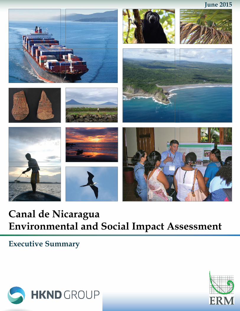
June 2015
Canal de Nicaragua Environmental and Social Impact AssessmentExecutive Summary
Executive Summary
Environmental and Social Impact Assessement • Canal de Nicaragua i
Table of Contents 1 Introduction ........................................................................................ 1
1.1 Project Purpose and Need ............................................................................................................1 1.2 Purpose of this ESIA .....................................................................................................................2 1.3 ERM’s Role ...................................................................................................................................3 1.4 Project Evaluation Criteria .............................................................................................................3 1.5 Project Context ..............................................................................................................................4
2 Route Selection................................................................................... 5 2.1 Alternative Route Study Area and Forest Cover Trends ...............................................................5 2.2 Comparison of Alternatives ...........................................................................................................8
3 Project Description ............................................................................. 9 3.1 Project Design .............................................................................................................................10 3.2 Project Construction ....................................................................................................................20 3.3 Project Operation.........................................................................................................................23 3.4 HKND’s Approved Embedded Controls .......................................................................................24
4 ESIA Process and Stakeholder Engagement .................................... 25 4.1 The ESIA Process .......................................................................................................................25 4.2 Stakeholder Engagement ............................................................................................................29
5 Key Issues and Concerns ................................................................. 31 5.1 Lago de Nicaragua ......................................................................................................................33 5.2 Soil Erosion and Sedimentation ..................................................................................................39 5.3 Biodiversity ..................................................................................................................................41 5.4 Land Expropriation and Resettlement .........................................................................................51 5.5 Indigenous Peoples .....................................................................................................................53 5.6 Project Affected Communities .....................................................................................................55 5.7 Influx and Induced Impacts ..........................................................................................................57 5.8 Cultural Heritage..........................................................................................................................59 5.9 Natural Hazards and Public Safety ..............................................................................................61 5.10 Trans-boundary Impacts ..............................................................................................................63
6 ESIA Conclusions and Recommendations ........................................ 65 6.1 Conclusions .................................................................................................................................65 6.2 Recommendations.......................................................................................................................75
Executive Summary
ii Environmental and Social Impact Assessment • Canal de Nicaragua
List of Appendices Appendix ES-A—Environmental and Social Action Plan Appendix ES-B—HKND Commitment Registry Appendix ES-C—ERM Recommended Additional Mitigation Measures
List of Figures Figure 1: Previously Identified Alternative Routes ...............................................................5
Figure 2: International Protected Areas and Indigenous Lands in the Study Area ..............6
Figure 3: Trends in Forest Cover in Project Area ................................................................7
Figure 4: Route 4 Preferred Alternative ...............................................................................8
Figure 5: Project Profile .......................................................................................................9
Figure 6: Project Segments ...............................................................................................11
Figure 7: Concept Lock with 3 Chambers and 9 Water Recycling Basins .........................12
Figure 8: West Canal Alternative Routes including the Modified Brito Alternative .............15
Figure 9: Caribbean Entrance Alternatives ........................................................................16
Figure 10: Atlanta Port Alternative .....................................................................................17
Figure 11: Two-Lock and Four-Lock Alternatives ..............................................................18
Figure 12: Conceptual Excavation Approach ....................................................................22
Figure 13: Overall Approach Schematic ............................................................................25
Figure 14: Impact Assessment Process ............................................................................26
Figure 15: Mitigation Hierarchy ..........................................................................................28
Figure 16: Example of Conceptual Impact Inter-relationships ...........................................31
Figure 17: Modeled Surface Currents in the Lago de Nicaragua ......................................35
Figure 18: East Canal Excavation Strategy .......................................................................40
Figure 19: Critical Habitat in the Project Area ....................................................................42
Figure 20: Proposed Designated Preservation Area .........................................................48
Figure 21 Impacts to San Miguelito Ramsar Site ..............................................................49
Figure 22: Key Factors Leading to High Rates of Influx and Large Migrant Populations ..57
Figure 23: Seismic Risk Zones in Nicaragua .....................................................................61
Figure 24: Location and Magnitude of Seismic Events in Nicaragua.................................62
Figure 25: Map of Río San Juan along the Nicaragua and Costa Rica Border .................63
Executive Summary
Environmental and Social Impact Assessement • Canal de Nicaragua iii
List of Tables Table 1: Comparison of International Canal Characteristics ...............................................2
Table 2: Canal Dimensions ...............................................................................................10
Table 3: Earthwork Quantities by Type and Canal Segment .............................................13
Table 4: Canal de Nicaragua Freight Traffic Prediction by Year (number of transits) .......23
Table 5: Evaluation of Significance ...................................................................................27
Table 6: Evaluation of Risk ................................................................................................27
Table 7: Key Issues and Concerns ....................................................................................32
Table 8: Metals Detected in Lago de Nicaragua Sediment ...............................................36
Table 9: Primary Project Data Gaps ..................................................................................66
Table 10: Estimated Project Operations Phase Employment ............................................68
Table 11: Comparison of Future Development Scenarios .................................................72
Table 12: IFC Performance Standards Non-Conformance ................................................73
Executive Summary
iv Environmental and Social Impact Assessment • Canal de Nicaragua
-Page Intentionally Left Blank-
Executive Summary
Environmental and Social Impact Assessement • Canal de Nicaragua 1
1 INTRODUCTION
The Canal de Nicaragua (here referred to as the “Project”) is a major infrastructure project with the potential to transform global trade and make Nicaragua a major center for transport and global logistics. The Project would be one of the largest civil works endeavors ever undertaken. Because of its size and international significance, it would impact (both positively and negatively) many resources—international trade, the economy of Nicaragua, biodiversity, water supply, indigenous rights, and many others. HK-Nicaragua Canal Development Investment Co., Limited (together with Empresa Desarrolladora de Grandes Infraestructuras S.A. and its other affiliates, [HKND]), is the Project sponsor. HKND is a privately-held infrastructure development firm headquartered in Hong Kong, with offices in Managua, Nicaragua. On 5 September 2012, HKND signed a Memorandum of Understanding with the Government of Nicaragua for a renewable 50-year concession to finance, construct, and operate the Project. On 13 June 2013, Nicaragua’s National Assembly ratified an exclusive agreement between the Government of Nicaragua and HKND to develop the Project (Law 840).
This Executive Summary provides an overview of the Project Environmental and Social Impact Assessment (ESIA). Cross references are made throughout this Executive Summary to corresponding sections in the full ESIA and to the Environmental and Social Action Plan (ESAP), which is attached as Appendix ES-A to this Executive Summary. An ESAP identifies and prioritizes actions needed to address gaps in the Project design, ESIA, management plans, management systems, or stakeholder engagement process to bring a Project in line with international standards.
1.1 PROJECT PURPOSE AND NEED The purpose and need for a Canal de Nicaragua is briefly considered below from the perspectives of the Government of Nicaragua and HKND as the Project sponsor.
Nicaragua is the second poorest country in Latin America and its growth is at least partially hindered by the lack of transport infrastructure, including international ports through which to export its products to international markets. Nicaragua only has to look as far as Panama to see the benefits of an international canal, as Panama is the second wealthiest country in Latin America. It is anticipated that construction and operation of a Canal de Nicaragua would significantly benefit the Nicaraguan economy as a result of: • Increased economic production, corporate diversity, and markets; • Increased jobs and reduced unemployment; • Increased personal income and spending; • Improved skills and experience of workers; and • Improved transport infrastructure via new roads and ports, in addition to the canal
itself.
Studies conducted for the Government of Nicaragua (Grand Canal Work Commission 2006) suggest that a canal could increase the national Gross Domestic Product per capita by almost 200 percent compared to projections without a canal, making a canal attractive, especially when it would be privately financed and ultimately transferred to the Government of Nicaragua ownership at no cost.
Executive Summary
2 Environmental and Social Impact Assessment • Canal de Nicaragua
HKND has not provided a market study indicating its “business case” for the Project, but available information indicates that it is primarily targeting container traffic and bulk carriers, much of which are vessels too large to fit through the expanded Panama Canal. Shipping trends are toward larger ships, while at the same time smaller ships are being scrapped. Nicaragua’s location, further north than the Panama Canal, provides shorter travel distances between eastern United States and Asia Pacific markets.
Table 1 compares the Project with the existing Suez Canal and the soon to be expanded Panama Canal.
Table 1: Comparison of International Canal Characteristics Parameters Nicaragua Suez Panamá (Expanded) Canal Depth (meters) 26.9–30.2 24 16.1 Canal Length, coast to coast (kilometers) 259 193 80 Canal Bottom Width (meters) 230-280 121 218-366 Ship Carrying Capacity (DWT) 400,000 240,000 170,000 Ship Container Cargo Capacity (TEU) 25,000 19,000+ 13,000 Ship Fully Loaded Draft (meters) 23 20 15 Lock Length (meters) 520 NA 427 Lock Width (meters) 75 NA 55
Fuentes: CDT 2006; ACP 2014
DWT—dry weight tons; TEU—twenty-foot equivalent units
1.2 PURPOSE OF THIS ESIA As described by the International Association of Impact Assessment, one of the foremost impact assessment professional associations, an impact assessment should: • Provide information for decision-making that analyzes the biophysical, social,
economic, and institutional consequences of proposed actions; • Promote transparency and participation of the public in decision-making; • Identify procedures and methods for the follow-up (monitoring and mitigation of
adverse consequences) in policy, planning and project cycles; and • Contribute to environmentally-sound and sustainable development.
Consistent with this definition, the purpose of this ESIA for the Project is to provide an objective, factual, and science-based assessment of both the process used in developing this ESIA and the likely impacts of the Project on the physical, biological, social, and economic environment, such that the Government of Nicaragua, the people of Nicaragua, civil society, and the international community can make an informed decision about the merits of the Project.

Executive Summary
Environmental and Social Impact Assessement • Canal de Nicaragua 3
1.3 ERM’S ROLE Environmental Resources Management (ERM) is a global sustainability consultancy company employed by HKND to serve as an independent advisor on international environmental and social standards. In this role, ERM’s intent is to: • Provide independent advice regarding international good practices for managing the
environmental and social effects of the Project; • Commit to an open and transparent ESIA process by carefully considering
stakeholder input and concerns and collaborating with expert panels to review the Project; and
• Be responsible for preparing an ESIA report that will provide the Government of Nicaragua and citizens of Nicaragua, as well as other stakeholders and interested parties, with independent, science-based, and objective information on which to make an informed decision about the merits of the Project.
In order to affirm our independence, ERM partnered with both international and Nicaraguan experts and conservation organizations in conducting the baseline studies for this ESIA, and helped convene an independent expert panel to review the preliminary ecological and hydrological findings of this ESIA.
ERM was not responsible for designing the Project, which is the responsibility of HKND and its engineering team, or approving/denying the Project, which is the responsibility of the Government of Nicaragua. ERM is neither an advocate for nor an opponent against, the Project.
1.4 PROJECT EVALUATION CRITERIA HKND has committed, and the Government of Nicaragua has required in its Terms of Reference, that the Project must comply with international good practice, specifically the Equator Principles, which require compliance with relevant host country laws, regulations, and permits; the International Finance Corporation’s (IFC) Performance Standards (PSs); and the World Bank Group’s Environmental, Health, and Safety Guidelines (WB EHS Guidelines). ERM used these standards as the basis for evaluating the Project. ERM’s findings are discussed in Chapter 6, ESIA Conclusions and Recommendations, of this Executive Summary.
HKND has also indicated as an objective that the Project achieves a Net Positive Impact, specifically on biodiversity resources, but more broadly for the Project. The concept of Net Positive Impact is described in more detail in Section 4.1, The ESIA Process, of this Executive Summary.
Executive Summary
4 Environmental and Social Impact Assessment • Canal de Nicaragua
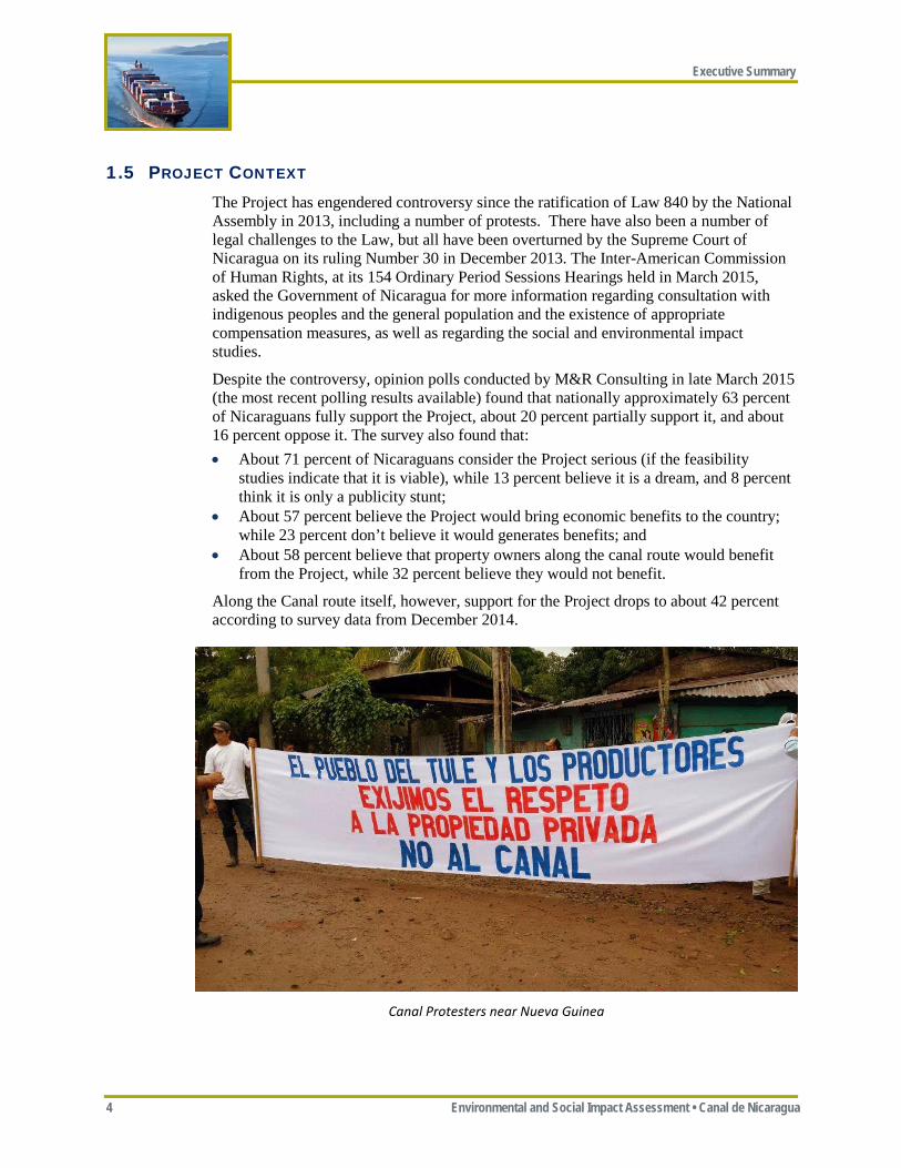
1.5 PROJECT CONTEXT The Project has engendered controversy since the ratification of Law 840 by the National Assembly in 2013, including a number of protests. There have also been a number of legal challenges to the Law, but all have been overturned by the Supreme Court of Nicaragua on its ruling Number 30 in December 2013. The Inter-American Commission of Human Rights, at its 154 Ordinary Period Sessions Hearings held in March 2015, asked the Government of Nicaragua for more information regarding consultation with indigenous peoples and the general population and the existence of appropriate compensation measures, as well as regarding the social and environmental impact studies.
Despite the controversy, opinion polls conducted by M&R Consulting in late March 2015 (the most recent polling results available) found that nationally approximately 63 percent of Nicaraguans fully support the Project, about 20 percent partially support it, and about 16 percent oppose it. The survey also found that: • About 71 percent of Nicaraguans consider the Project serious (if the feasibility
studies indicate that it is viable), while 13 percent believe it is a dream, and 8 percent think it is only a publicity stunt;
• About 57 percent believe the Project would bring economic benefits to the country; while 23 percent don’t believe it would generates benefits; and
• About 58 percent believe that property owners along the canal route would benefit from the Project, while 32 percent believe they would not benefit.
Along the Canal route itself, however, support for the Project drops to about 42 percent according to survey data from December 2014.
Canal Protesters near Nueva Guinea
Executive Summary
Environmental and Social Impact Assessement • Canal de Nicaragua 5
2 ROUTE SELECTION
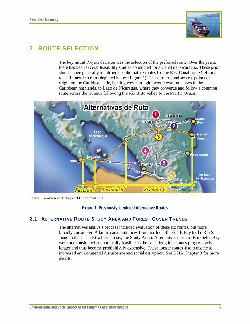
The key initial Project decision was the selection of the preferred route. Over the years, there has been several feasibility studies conducted for a Canal de Nicaragua. These prior studies have generally identified six alternative routes for the East Canal route (referred to as Routes 1 to 6) as depicted below (Figure 1). These routes had several points of origin on the Caribbean side, bearing west through lower elevation passes in the Caribbean highlands, to Lago de Nicaragua, where they converge and follow a common route across the isthmus following the Río Brito valley to the Pacific Ocean.
Source: Comision de Trabajo del Gran Canal 2006
Figure 1: Previously Identified Alternative Routes
2.1 ALTERNATIVE ROUTE STUDY AREA AND FOREST COVER TRENDS The alternatives analysis process included evaluation of these six routes, but more broadly considered Atlantic canal entrances from north of Bluefields Bay to the Río San Juan on the Costa Rica border (i.e., the Study Area). Alternatives north of Bluefields Bay were not considered economically feasible as the canal length becomes progressively longer and thus become prohibitively expensive. These longer routes also translate to increased environmental disturbance and social disruption. See ESIA Chapter 3 for more details.
Executive Summary
6 Environmental and Social Impact Assessment • Canal de Nicaragua
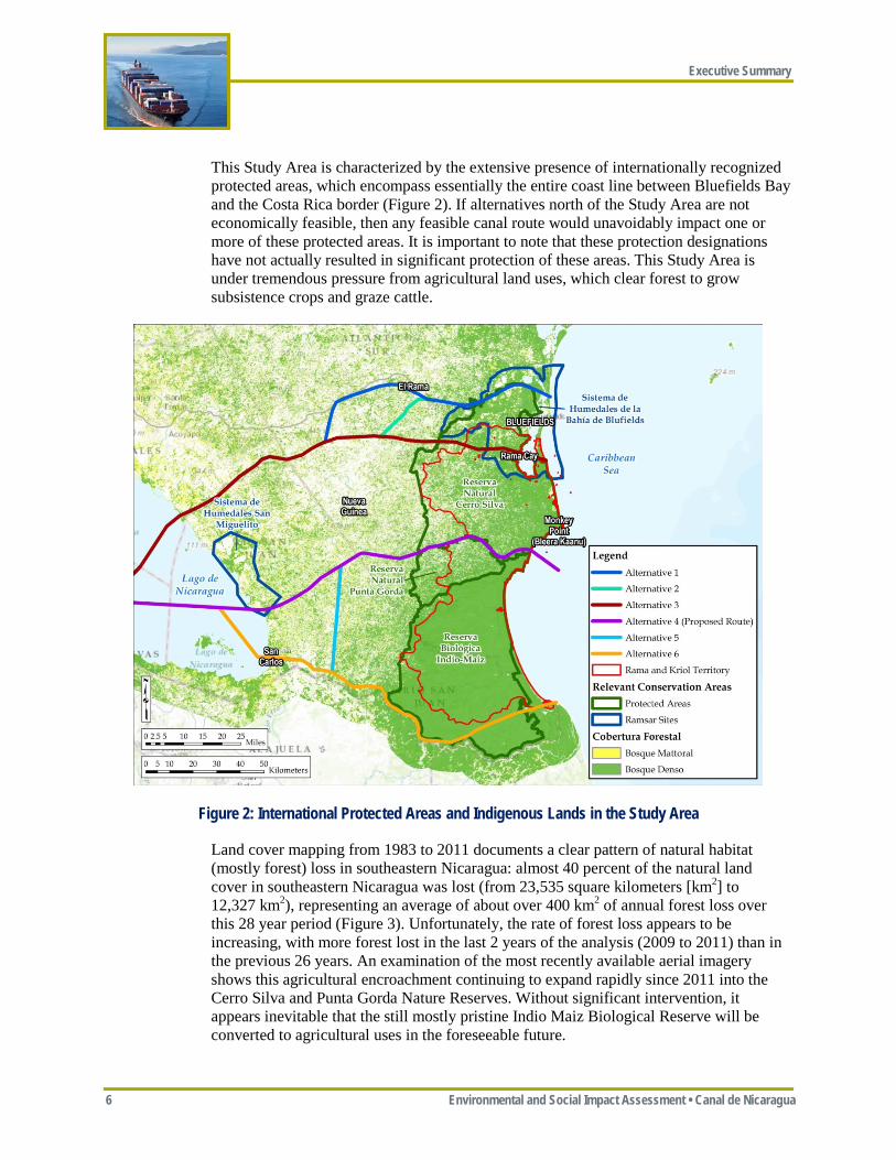
This Study Area is characterized by the extensive presence of internationally recognized protected areas, which encompass essentially the entire coast line between Bluefields Bay and the Costa Rica border (Figure 2). If alternatives north of the Study Area are not economically feasible, then any feasible canal route would unavoidably impact one or more of these protected areas. It is important to note that these protection designations have not actually resulted in significant protection of these areas. This Study Area is under tremendous pressure from agricultural land uses, which clear forest to grow subsistence crops and graze cattle.
Figure 2: International Protected Areas and Indigenous Lands in the Study Area
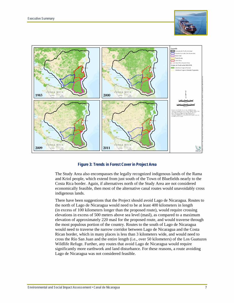
Land cover mapping from 1983 to 2011 documents a clear pattern of natural habitat (mostly forest) loss in southeastern Nicaragua: almost 40 percent of the natural land cover in southeastern Nicaragua was lost (from 23,535 square kilometers [km2] to 12,327 km2), representing an average of about over 400 km2 of annual forest loss over this 28 year period (Figure 3). Unfortunately, the rate of forest loss appears to be increasing, with more forest lost in the last 2 years of the analysis (2009 to 2011) than in the previous 26 years. An examination of the most recently available aerial imagery shows this agricultural encroachment continuing to expand rapidly since 2011 into the Cerro Silva and Punta Gorda Nature Reserves. Without significant intervention, it appears inevitable that the still mostly pristine Indio Maiz Biological Reserve will be converted to agricultural uses in the foreseeable future.
Executive Summary
Environmental and Social Impact Assessement • Canal de Nicaragua 7
Figure 3: Trends in Forest Cover in Project Area
The Study Area also encompasses the legally recognized indigenous lands of the Rama and Kriol people, which extend from just south of the Town of Bluefields nearly to the Costa Rica border. Again, if alternatives north of the Study Area are not considered economically feasible, then most of the alternative canal routes would unavoidably cross indigenous lands.
There have been suggestions that the Project should avoid Lago de Nicaragua. Routes to the north of Lago de Nicaragua would need to be at least 400 kilometers in length (in excess of 100 kilometers longer than the proposed route), would require crossing elevations in excess of 500 meters above sea level (masl), as compared to a maximum elevation of approximately 220 masl for the proposed route, and would traverse through the most populous portion of the country. Routes to the south of Lago de Nicaragua would need to traverse the narrow corridor between Lago de Nicaragua and the Costa Rican border, which in many places is less than 3 kilometers wide, and would need to cross the Río San Juan and the entire length (i.e., over 50 kilometers) of the Los Guatuzos Wildlife Refuge. Further, any routes that avoid Lago de Nicaragua would require significantly more earthwork and land disturbance. For these reasons, a route avoiding Lago de Nicaragua was not considered feasible.
Executive Summary
8 Environmental and Social Impact Assessment • Canal de Nicaragua
2.2 COMPARISON OF ALTERNATIVES All economically feasible routes for a Canal de Nicaragua through the Study Area would have significant environmental and social impacts, as they would need to traverse internationally recognized protected areas, legally-recognized indigenous lands, and Lago de Nicaragua, all of which under normal circumstances would be considered no-go areas. ERM considers all the routes through Bluefields Bay (Routes 1, 2, and 3) as having unacceptably high impacts to the Bluefields Bay Ramsar Wetlands, which are still generally intact and in good condition, the hydrodynamics of Bluefields Bay by widening and deepening its connection with the Caribbean Sea, the traditional lands of the Rama Kriol people, ecosystem services on which the residents of Bluefields Bay depend, endangered sea turtle nesting and foraging habitat, and comparatively higher population density areas, as well as having high construction costs. ERM considers all the routes south of the Río Punta Gorda (Routes 5 and 6) as having unacceptably high impacts to the still pristine Indio Maiz Biological Reserve and the globally important El Cocal nesting area for several species of endangered sea turtles, as well as potential trans-boundary issues with Costa Rica.
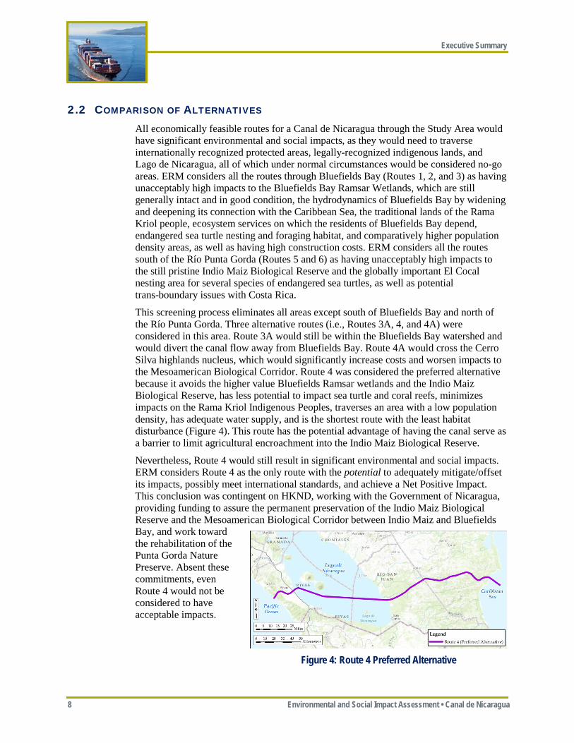
This screening process eliminates all areas except south of Bluefields Bay and north of the Río Punta Gorda. Three alternative routes (i.e., Routes 3A, 4, and 4A) were considered in this area. Route 3A would still be within the Bluefields Bay watershed and would divert the canal flow away from Bluefields Bay. Route 4A would cross the Cerro Silva highlands nucleus, which would significantly increase costs and worsen impacts to the Mesoamerican Biological Corridor. Route 4 was considered the preferred alternative because it avoids the higher value Bluefields Ramsar wetlands and the Indio Maiz Biological Reserve, has less potential to impact sea turtle and coral reefs, minimizes impacts on the Rama Kriol Indigenous Peoples, traverses an area with a low population density, has adequate water supply, and is the shortest route with the least habitat disturbance (Figure 4). This route has the potential advantage of having the canal serve as a barrier to limit agricultural encroachment into the Indio Maiz Biological Reserve.
Nevertheless, Route 4 would still result in significant environmental and social impacts. ERM considers Route 4 as the only route with the potential to adequately mitigate/offset its impacts, possibly meet international standards, and achieve a Net Positive Impact. This conclusion was contingent on HKND, working with the Government of Nicaragua, providing funding to assure the permanent preservation of the Indio Maiz Biological Reserve and the Mesoamerican Biological Corridor between Indio Maiz and Bluefields Bay, and work toward the rehabilitation of the Punta Gorda Nature Preserve. Absent these commitments, even Route 4 would not be considered to have acceptable impacts.
Figure 4: Route 4 Preferred Alternative
Executive Summary
Environmental and Social Impact Assessement • Canal de Nicaragua 9
3 PROJECT DESCRIPTION
This section describes both the Project as currently proposed by HKND and alternatives to the Project that were considered. Project facilities are described below in as much detail as is available at this stage of the Project design. This Project description relies heavily on preliminary engineering prepared by China Railway Construction Corporation (CRCC)/ChangJiang (overall Project technical feasibility, concept design, and engineering), MEC (earthworks strategy and engineering), and SBE/Deltares (lock design and operations, freshwater availability, and salinity management).
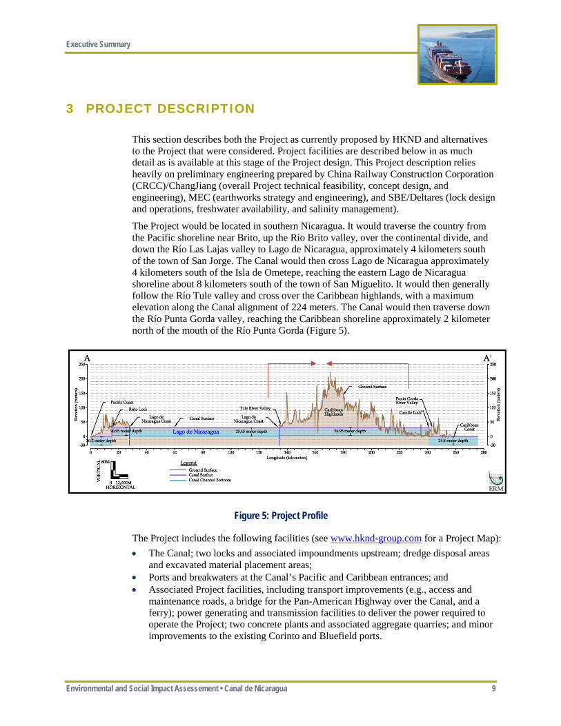
The Project would be located in southern Nicaragua. It would traverse the country from the Pacific shoreline near Brito, up the Río Brito valley, over the continental divide, and down the Río Las Lajas valley to Lago de Nicaragua, approximately 4 kilometers south of the town of San Jorge. The Canal would then cross Lago de Nicaragua approximately 4 kilometers south of the Isla de Ometepe, reaching the eastern Lago de Nicaragua shoreline about 8 kilometers south of the town of San Miguelito. It would then generally follow the Río Tule valley and cross over the Caribbean highlands, with a maximum elevation along the Canal alignment of 224 meters. The Canal would then traverse down the Río Punta Gorda valley, reaching the Caribbean shoreline approximately 2 kilometer north of the mouth of the Río Punta Gorda (Figure 5).
Figure 5: Project Profile
The Project includes the following facilities (see www.hknd-group.com for a Project Map): • The Canal; two locks and associated impoundments upstream; dredge disposal areas
and excavated material placement areas; • Ports and breakwaters at the Canal’s Pacific and Caribbean entrances; and • Associated Project facilities, including transport improvements (e.g., access and
maintenance roads, a bridge for the Pan-American Highway over the Canal, and a ferry); power generating and transmission facilities to deliver the power required to operate the Project; two concrete plants and associated aggregate quarries; and minor improvements to the existing Corinto and Bluefield ports.
Executive Summary
10 Environmental and Social Impact Assessment • Canal de Nicaragua
Other facilities have been proposed, including a Free Trade Zone and associated commercial developments, tourist hotels, and an airport. Construction of these facilities would begin when the Project construction is well advanced, which is 5 or more years in the future. Further, little information exists at this time to allow a full impact assessment of these facilities. For these reasons, these other facilities are not included as part of the Project addressed in this ESIA, but are considered in the analysis of potential cumulative impacts (see ESIA Chapter 12).
3.1 PROJECT DESIGN
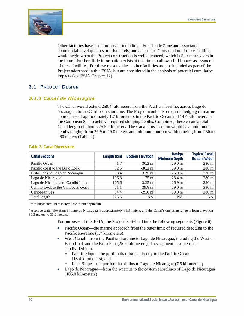
3.1.1 Canal de Nicaragua The Canal would extend 259.4 kilometers from the Pacific shoreline, across Lago de Nicaragua, to the Caribbean shoreline. The Project would also require dredging of marine approaches of approximately 1.7 kilometers in the Pacific Ocean and 14.4 kilometers in the Caribbean Sea to achieve required shipping depths. Combined, these create a total Canal length of about 275.5 kilometers. The Canal cross section would have minimum depths ranging from 26.9 to 29.0 meters and minimum bottom width ranging from 230 to 280 meters (Table 2).
Table 2: Canal Dimensions
Canal Sections Length (km) Bottom Elevation Design Minimum Depth
Typical Canal Bottom Width
Pacific Ocean 1.7 -30.2 m 29.0 m 280 m Pacific coast to the Brito Lock 12.5 -30.2 m 29.0 m 280 m Brito Lock to Lago de Nicaragua 13.4 3.25 m 26.9 m 230 m Lago de Nicaraguaa 106.8 1.75 m 28.4 m 280 m Lago de Nicaragua to Camilo Lock 105.6 3.25 m 26.9 m 230 m Camilo Lock to the Caribbean coast 21.1 -29.8 m 29.0 m 280 m Caribbean Sea 14.4 -29.8 m 29.0 m 280 m Total length 275.5 NA NA NA
km = kilometers; m = meters; NA = not applicable a Average water elevation in Lago de Nicaragua is approximately 31.3 meters, and the Canal’s operating range is from elevation 30.2 meters to 33.0 meters.
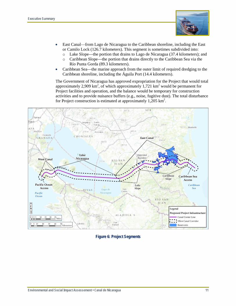
For purposes of this ESIA, the Project is divided into the following segments (Figure 6): • Pacific Ocean—the marine approach from the outer limit of required dredging to the
Pacific shoreline (1.7 kilometers). • West Canal—from the Pacific shoreline to Lago de Nicaragua, including the West or
Brito Lock and the Brito Port (25.9 kilometers). This segment is sometimes subdivided into: o Pacific Slope—the portion that drains directly to the Pacific Ocean
(18.4 kilometers); and o Lake Slope—the portion that drains to Lago de Nicaragua (7.5 kilometers).
• Lago de Nicaragua—from the western to the eastern shorelines of Lago de Nicaragua (106.8 kilometers).
Executive Summary
Environmental and Social Impact Assessement • Canal de Nicaragua 11
• East Canal—from Lago de Nicaragua to the Caribbean shoreline, including the East or Camilo Lock (126.7 kilometers). This segment is sometimes subdivided into: o Lake Slope—the portion that drains to Lago de Nicaragua (37.4 kilometers); and o Caribbean Slope—the portion that drains directly to the Caribbean Sea via the
Río Punta Gorda (89.3 kilometers). • Caribbean Sea—the marine approach from the outer limit of required dredging to the
Caribbean shoreline, including the Águila Port (14.4 kilometers).
The Government of Nicaragua has approved expropriation for the Project that would total approximately 2,909 km2, of which approximately 1,721 km2 would be permanent for Project facilities and operation, and the balance would be temporary for construction activities and to provide nuisance buffers (e.g., noise, fugitive dust). The total disturbance for Project construction is estimated at approximately 1,205 km2.
Figure 6: Project Segments
Executive Summary
12 Environmental and Social Impact Assessment • Canal de Nicaragua
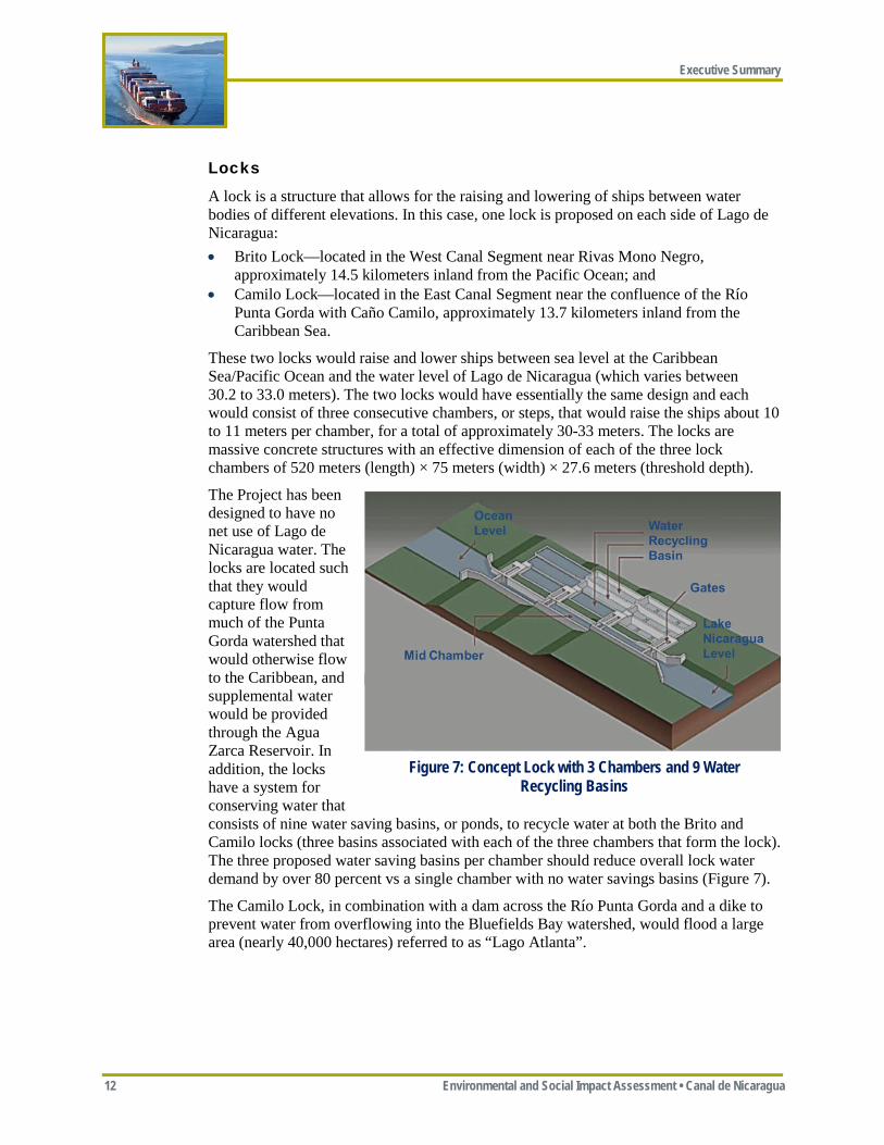
Locks
A lock is a structure that allows for the raising and lowering of ships between water bodies of different elevations. In this case, one lock is proposed on each side of Lago de Nicaragua: • Brito Lock—located in the West Canal Segment near Rivas Mono Negro,
approximately 14.5 kilometers inland from the Pacific Ocean; and • Camilo Lock—located in the East Canal Segment near the confluence of the Río
Punta Gorda with Caño Camilo, approximately 13.7 kilometers inland from the Caribbean Sea.
These two locks would raise and lower ships between sea level at the Caribbean Sea/Pacific Ocean and the water level of Lago de Nicaragua (which varies between 30.2 to 33.0 meters). The two locks would have essentially the same design and each would consist of three consecutive chambers, or steps, that would raise the ships about 10 to 11 meters per chamber, for a total of approximately 30-33 meters. The locks are massive concrete structures with an effective dimension of each of the three lock chambers of 520 meters (length) × 75 meters (width) × 27.6 meters (threshold depth).
The Project has been designed to have no net use of Lago de Nicaragua water. The locks are located such that they would capture flow from much of the Punta Gorda watershed that would otherwise flow to the Caribbean, and supplemental water would be provided through the Agua Zarca Reservoir. In addition, the locks have a system for conserving water that consists of nine water saving basins, or ponds, to recycle water at both the Brito and Camilo locks (three basins associated with each of the three chambers that form the lock). The three proposed water saving basins per chamber should reduce overall lock water demand by over 80 percent vs a single chamber with no water savings basins (Figure 7).
The Camilo Lock, in combination with a dam across the Río Punta Gorda and a dike to prevent water from overflowing into the Bluefields Bay watershed, would flood a large area (nearly 40,000 hectares) referred to as “Lago Atlanta”.
Figure 7: Concept Lock with 3 Chambers and 9 Water Recycling Basins
Executive Summary
Environmental and Social Impact Assessement • Canal de Nicaragua 13
Excavated Material Placement Areas (EMPAs)
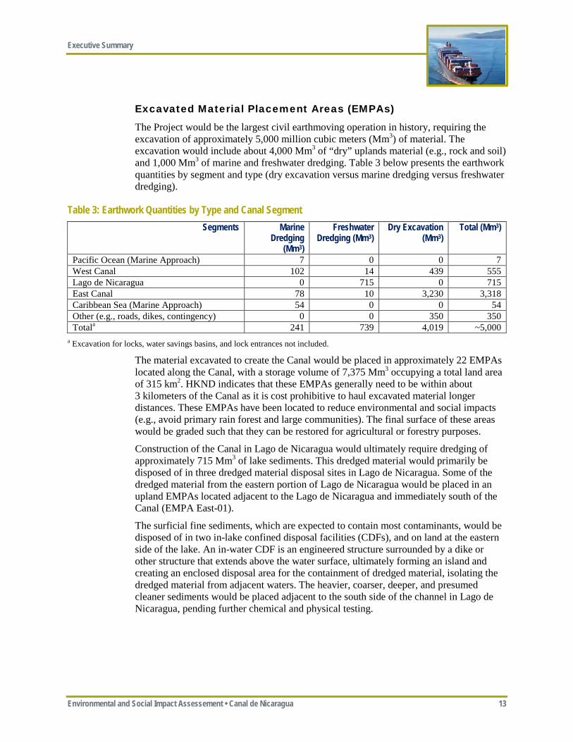
The Project would be the largest civil earthmoving operation in history, requiring the excavation of approximately 5,000 million cubic meters (Mm3) of material. The excavation would include about 4,000 Mm3 of “dry” uplands material (e.g., rock and soil) and 1,000 Mm3 of marine and freshwater dredging. Table 3 below presents the earthwork quantities by segment and type (dry excavation versus marine dredging versus freshwater dredging).
Table 3: Earthwork Quantities by Type and Canal Segment Segments Marine
Dredging (Mm3)
Freshwater Dredging (Mm3)
Dry Excavation (Mm3)
Total (Mm3)
Pacific Ocean (Marine Approach) 7 0 0 7 West Canal 102 14 439 555 Lago de Nicaragua 0 715 0 715 East Canal 78 10 3,230 3,318 Caribbean Sea (Marine Approach) 54 0 0 54 Other (e.g., roads, dikes, contingency) 0 0 350 350 Totala 241 739 4,019 ~5,000
a Excavation for locks, water savings basins, and lock entrances not included.
The material excavated to create the Canal would be placed in approximately 22 EMPAs located along the Canal, with a storage volume of 7,375 Mm3 occupying a total land area of 315 km2. HKND indicates that these EMPAs generally need to be within about 3 kilometers of the Canal as it is cost prohibitive to haul excavated material longer distances. These EMPAs have been located to reduce environmental and social impacts (e.g., avoid primary rain forest and large communities). The final surface of these areas would be graded such that they can be restored for agricultural or forestry purposes.
Construction of the Canal in Lago de Nicaragua would ultimately require dredging of approximately 715 Mm3 of lake sediments. This dredged material would primarily be disposed of in three dredged material disposal sites in Lago de Nicaragua. Some of the dredged material from the eastern portion of Lago de Nicaragua would be placed in an upland EMPAs located adjacent to the Lago de Nicaragua and immediately south of the Canal (EMPA East-01).
The surficial fine sediments, which are expected to contain most contaminants, would be disposed of in two in-lake confined disposal facilities (CDFs), and on land at the eastern side of the lake. An in-water CDF is an engineered structure surrounded by a dike or other structure that extends above the water surface, ultimately forming an island and creating an enclosed disposal area for the containment of dredged material, isolating the dredged material from adjacent waters. The heavier, coarser, deeper, and presumed cleaner sediments would be placed adjacent to the south side of the channel in Lago de Nicaragua, pending further chemical and physical testing.
Executive Summary
14 Environmental and Social Impact Assessment • Canal de Nicaragua
3.1.2 Port Facilities HKND proposes to construct two ports—one on the Pacific, referred to as the Brito Port, and one on the Caribbean, referred to as the Águila Port. These ports would provide logistical support during the construction of the Project and would afterwards serve as trans-shipment ports for container handling and normal cargo loading, as well as each having an oil depot. The Brito Port, which would be located about 3 kilometers inland from the Pacific to improve constructability and enhance port reliability, would have a design capacity of 1.7 million twenty-foot equivalent units per year (TEU/year). The Águila Port, which would be located near the Caribbean entrance to the Canal, would have a design capacity of 2.5 million TEU/year.
3.1.3 Associated Project Facilities HKND also proposes to construct the following associated Project facilities: • Pan-American Highway Bridge—HKND proposes to construct a new Pan-American
Highway Bridge over the Canal; • Nicaragua Route 25 Ferry—HKND proposes to construct ferry landings and operate
a ferry at the point where the Canal crosses Route 25—the Acoyapa-San Carlos road; • New public and maintenance roads—HKND proposes to construct new public roads
that would parallel portions of the Canal, as well as private maintenance roads that would have restricted access;
• Agua Zarca Hydropower Facility—HKND proposes to construct an approximately 10 megawatt (MW) hydropower project south of the East Canal Segment to provide electricity to operate the Camilo Lock and to provide supplemental water to operate the Project without affecting water levels in Lago de Nicaragua during dry periods;
• Electric transmission line extensions to both the Brito and Camilo locks—HKND proposes to construct approximately 125 kilometers of new transmission lines to connect both proposed locks with the national electrical grid, as well as a new 69 kilovolt (kV) electrical substation near each lock;
• Concrete batch plants and aggregate quarries—HKND proposes to create aggregate quarries and construct batch plants to support construction of the locks;
• Offices and worker camps—HKND proposes a construction management/operations office near Rivas and approximately nine construction worker camps along the Canal route;
• Fuel Storage Depots—HKND proposes both temporary and permanent fuel storage depots at both the Brito and Águila ports; and
• Minor improvements to the Corinto and El Bluff ports—HKND proposes to make minor improvements within the footprint at these two existing ports to improve their capacity to accept Project-related deliveries.
3.1.4 Alternatives Both alignment and design alternatives were considered for the Project. Each of these is briefly described below. See ESIA Section 3.7, Project Alternatives, for additional details.
Executive Summary
Environmental and Social Impact Assessement • Canal de Nicaragua 15
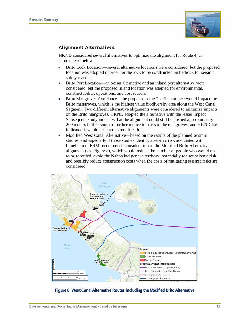
Alignment Alternatives
HKND considered several alternatives to optimize the alignment for Route 4, as summarized below: • Brito Lock Location—several alternative locations were considered, but the proposed
location was adopted in order for the lock to be constructed on bedrock for seismic safety reasons;
• Brito Port Location—an ocean alternative and an inland port alternative were considered, but the proposed inland location was adopted for environmental, constructability, operations, and cost reasons;
• Brito Mangroves Avoidance—the proposed route Pacific entrance would impact the Brito mangroves, which is the highest value biodiversity area along the West Canal Segment. Two different alternative alignments were considered to minimize impacts on the Brito mangroves. HKND adopted the alternative with the lesser impact. Subsequent study indicates that the alignment could still be pushed approximately 200 meters farther south to further reduce impacts to the mangroves, and HKND has indicated it would accept this modification;
• Modified West Canal Alternative—based on the results of the planned seismic studies, and especially if those studies identify a seismic risk associated with liquefaction, ERM recommends consideration of the Modified Brito Alternative alignment (see Figure 8), which would reduce the number of people who would need to be resettled, avoid the Nahoa indigenous territory, potentially reduce seismic risk, and possibly reduce construction costs when the costs of mitigating seismic risks are considered;
Figure 8: West Canal Alternative Routes including the Modified Brito Alternative
Executive Summary
16 Environmental and Social Impact Assessment • Canal de Nicaragua
• Lago de Nicaragua Alternatives—three different alignments across Lago de Nicaragua were considered. HKND adopted the preferred alternative that minimizes impacts to the San Miguelito Ramsar Wetlands, avoids the need to resettle the Town of El Tule, and maintains adequate buffers to Zanate, Archipielago de Solentiname, and Ometepe islands in the lake;
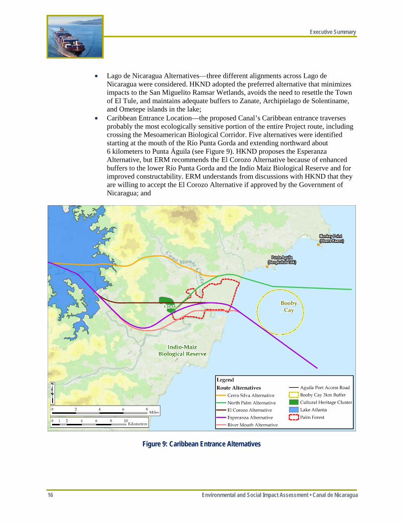
• Caribbean Entrance Location—the proposed Canal’s Caribbean entrance traverses probably the most ecologically sensitive portion of the entire Project route, including crossing the Mesoamerican Biological Corridor. Five alternatives were identified starting at the mouth of the Río Punta Gorda and extending northward about 6 kilometers to Punta Águila (see Figure 9). HKND proposes the Esperanza Alternative, but ERM recommends the El Corozo Alternative because of enhanced buffers to the lower Río Punta Gorda and the Indio Maiz Biological Reserve and for improved constructability. ERM understands from discussions with HKND that they are willing to accept the El Corozo Alternative if approved by the Government of Nicaragua; and
Figure 9: Caribbean Entrance Alternatives
Executive Summary
Environmental and Social Impact Assessement • Canal de Nicaragua 17
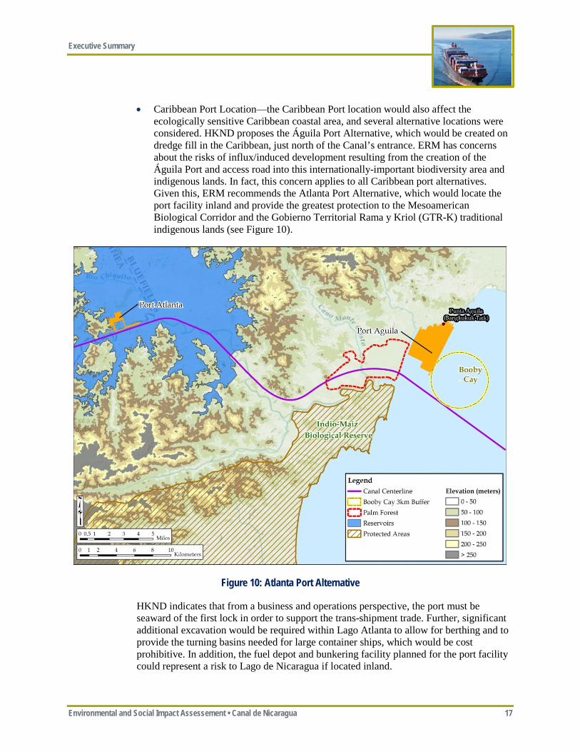
• Caribbean Port Location—the Caribbean Port location would also affect the ecologically sensitive Caribbean coastal area, and several alternative locations were considered. HKND proposes the Águila Port Alternative, which would be created on dredge fill in the Caribbean, just north of the Canal’s entrance. ERM has concerns about the risks of influx/induced development resulting from the creation of the Águila Port and access road into this internationally-important biodiversity area and indigenous lands. In fact, this concern applies to all Caribbean port alternatives. Given this, ERM recommends the Atlanta Port Alternative, which would locate the port facility inland and provide the greatest protection to the Mesoamerican Biological Corridor and the Gobierno Territorial Rama y Kriol (GTR-K) traditional indigenous lands (see Figure 10).
Figure 10: Atlanta Port Alternative
HKND indicates that from a business and operations perspective, the port must be seaward of the first lock in order to support the trans-shipment trade. Further, significant additional excavation would be required within Lago Atlanta to allow for berthing and to provide the turning basins needed for large container ships, which would be cost prohibitive. In addition, the fuel depot and bunkering facility planned for the port facility could represent a risk to Lago de Nicaragua if located inland.
Executive Summary
18 Environmental and Social Impact Assessment • Canal de Nicaragua
If we accept that a Caribbean port is critical to the overall Project business case, we are left with the situation where HKND does not have the legal authority to control influx into this ecologically and cultural sensitive area that the Project may attract. Adoption of the Águila Port Alternative would require strong regional land use planning and enforcement by the Government of Nicaragua. ERM considers this potential for influx into the narrow remainder of the Mesoamerican Biological Corridor and the Gobierno Territorial Rama y Kriol (GTR-K) indigenous lands as one of the most significant Project risks.
Design Alternatives
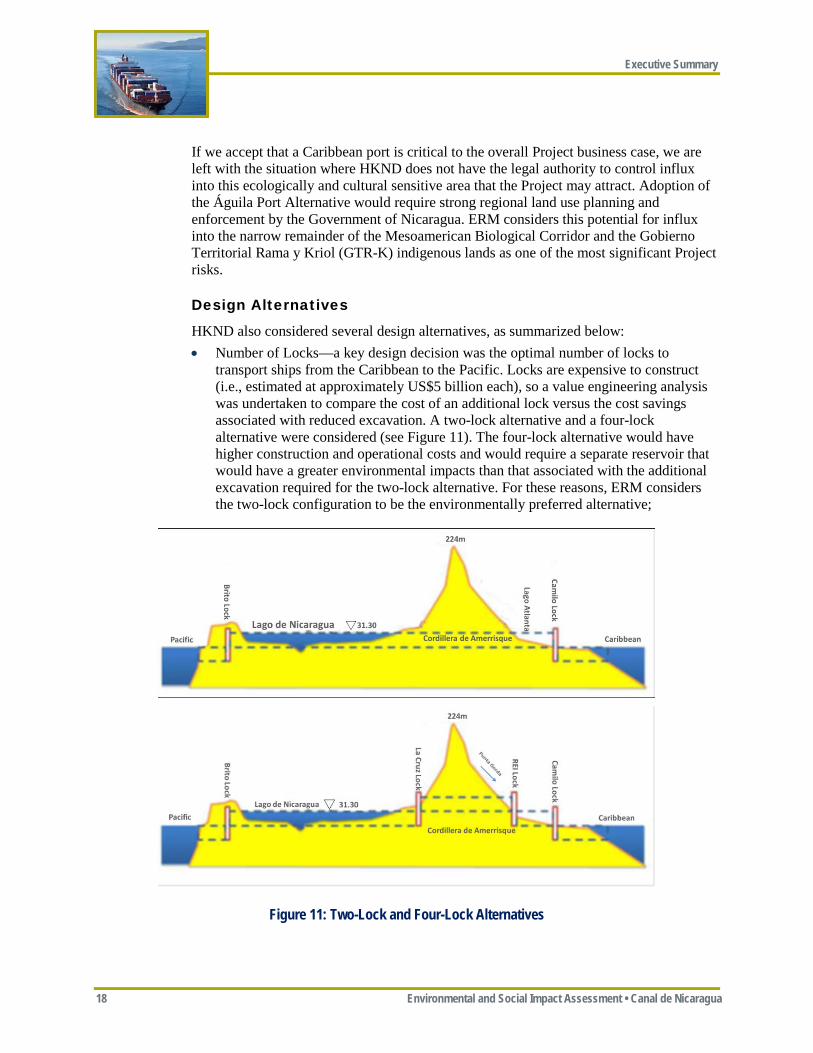
HKND also considered several design alternatives, as summarized below: • Number of Locks—a key design decision was the optimal number of locks to
transport ships from the Caribbean to the Pacific. Locks are expensive to construct (i.e., estimated at approximately US$5 billion each), so a value engineering analysis was undertaken to compare the cost of an additional lock versus the cost savings associated with reduced excavation. A two-lock alternative and a four-lock alternative were considered (see Figure 11). The four-lock alternative would have higher construction and operational costs and would require a separate reservoir that would have a greater environmental impacts than that associated with the additional excavation required for the two-lock alternative. For these reasons, ERM considers the two-lock configuration to be the environmentally preferred alternative;
Figure 11: Two-Lock and Four-Lock Alternatives
Executive Summary
Environmental and Social Impact Assessement • Canal de Nicaragua 19
• Water Supply—during most of the rainy season in eastern Nicaragua, the daily average flow in the Río Punta Gorda exceeds the Project’s daily water demand (including both locks). “Excess” water would be stored in the Canal/Lago de Nicaragua behind the locks. This stored water, minus evaporation and Río San Juan outflow losses, would be available to supply water for Canal operations during the dry season. Water modeling shows that during extended dry periods, additional water may be needed to augment this stored water. Several reservoirs were considered for providing supplemental supply in order to ensure sufficient water for uninterrupted operations during the dry season and achieving no net use of Lago de Nicaragua water. HKND proposes the Agua Zarca Reservoir, which appears to be preferred as it would have a smaller footprint and would require the resettlement of fewer people;
• Single versus Split East Lock—the locks can be either single (all three chambers in a single structure) or split (the three chambers split between two structures). In general, a single lock is preferred because it is less expensive to build and operate (a split lock would roughly double operational costs). HKND proposes a single lock for both the West and East Locks. For the West Lock, a single lock is appropriate and a split lock offers no real benefits because of the relatively short length of the West Canal. For the East Canal Lock, however, ERM thinks a split lock is worth considering because of the significant area flooded by the single 30-meter Camilo Lock (approximately 40,000 hectares), the extent of resettlement required, the improved effectiveness of a split lock in controlling salinity intrusion to Lago de Nicaragua, and the long-term safety of the Lago Atlanta Dike. ERM recommends that an integrated water balance/salinity/lock location and design study be conducted to optimize the location and design (single vs split) of the East Lock, with the goals of reducing the size and length of the Lago Atlanta Dike for safety reasons, reducing the surface area of Lago Atlanta for environmental and social reasons, reducing salinity impacts above the lock, and maintaining negligible impacts on water levels in Lago de Nicaragua.
• Canal Depth and Width—a key component of the business case for the Project is its ability to accommodate ships that are too large to fit in the Panama Canal. The depth and width of the Canal relate directly to both the disturbance footprint of the Project and the footprint of the area required for excavated material placement. Therefore, reducing the Canal’s design depth and width would reduce the Project’s overall disturbance. It is clearly in HKND’s interests to optimize the Canal’s depth and width as well because excavation is the largest component of the overall Project’s costs.
• Upland EMPAs—the Project would require approximately 4,000 Mm3 of dry excavation. The costs of hauling excavated material are high. HKND proposes to place excavated material within 2 to 3 kilometers along both sides of much of the Canal. HKND has broadly adhered to guidelines for minimizing the environmental and social impacts associated with excavated material placement proposed by ERM; although ERM believes that there may be additional opportunities to optimize the EMPA footprint and height as part of the detailed design process in order to further avoid or reduce environmental (e.g., minimize impacts on intact forest) and social (e.g., avoid small communities) impacts.
• Lago de Nicaragua Dredge Material Placement Areas—the Project would require the dredging of approximately 715 Mm3 of sediments in Lago de Nicaragua. Several alternatives were considered for dredge material placement, including:
Executive Summary
20 Environmental and Social Impact Assessment • Canal de Nicaragua
o Onshore dredge material disposal, which would be the preferred option; however, HKND indicates that the width of the lake (about 105 kilometers) makes it cost prohibitive to haul all the dredge material back to shore;
o Open water disposal in Lago de Nicaragua, but this would result in unacceptable impacts to water quality and aquatic ecology in the lake, at least for the finer sediments. HKND proposes open water disposal for coarser sediments that would settle almost immediately; and
o CDFs, which are engineered facilities proposed by HKND for the disposal of fine sediments. Two facilities are proposed that were located so as to avoid higher value benthic habitat, maximize buffers to protected areas (e.g., Solentiname), and avoid commonly used shipping and fishing areas.
3.2 PROJECT CONSTRUCTION HKND proposes to complete Project construction in approximately 5 years, including an initial mobilization period of approximately 6 months, with Project operations beginning in 2019. This is a challenging schedule and would create significant logistical, procurement, and workforce challenges.
3.2.1 Construction Workforce HKND estimates an average annual workforce of approximately 50,000 employees during the 5-year construction period, with up to 50 percent of this workforce being recruited from within Nicaragua. It is likely, however, that a core contingent of experienced personnel (e.g. management staff, training personnel, selected equipment operators) would be required to be employed on an expatriate basis, with about 25 percent from China and 25 percent from other countries.
The Project would require approximately 1,500 office/administrative positions and approximately 48,500 field-based positions. Nicaragua has a very limited highly skilled workforce readily available. This has major implications for staffing of the Project, as a significant investment in training would be required, specifically for maintenance personnel and equipment operators.
Assuming approximately 48,500 field-based workers, the nine proposed worker camps would need to accommodate about 5,400 workers each on average. Worker camps are intended for use strictly by construction workers; worker families would not be accommodated. All foreign workers would be expected to reside in the worker camps, although some management staff working from the Construction Management Office could be housed separately in Rivas and towns adjacent to the East Canal Segment. Otherwise, only workers from nearby communities would be allowed to live outside the camps in order to minimize impacts on nearby communities and to reduce the potential for influx.
3.2.2 Construction Procedures Construction would occur simultaneously in three Project segments: West Canal, Lago de Nicaragua, and East Canal. The Camilo Lock and the East Canal earthworks are the largest challenges, not just because of the volume of earthwork but because of the difficult access, logistics, and weather conditions. Early commencement of East Canal
Executive Summary
Environmental and Social Impact Assessement • Canal de Nicaragua 21
Segment construction is a priority, and this requires early opening of access to the Camilo Lock in particular. The West Canal Segment has significantly less earthwork as well as better access and weather conditions, but is located in a seismically active area and construction of the Project and especially the Brito Lock would require additional engineering measures to ensure safety. Similarly, the work in Lago de Nicaragua is a challenging operation because of the difficulty in getting large dredging equipment into the lake and because of environmental concerns. In all likelihood, the actual critical path may run through each of the three segments at different times, depending on specific events that affect them. These considerations demand that site infrastructure and facilities be established across the whole Project at the earliest possible time.
Upland Construction
The Project would need to excavate nearly 4,000 Mm3 of upland earthwork, much of which would be in areas that receive high rainfall. Wet weather is one of the main earthworks challenges and has a major impact on excavation efficiency. Scheduling around rainfall events and managing the sequence of excavation such that watercourse flows do not impact the work unnecessarily is critical. For the East Canal Segment, as much of the watercourse flows as possible need to be diverted westward over completed sections of the Project rather than being allowed to flow eastward over uncompleted works.
After clearing vegetation, dry excavation would be undertaken in the following sequence: • Strip Topsoil—topsoil would be stripped using 100-ton excavators and 40-ton, all-
wheel drive trucks. This material would either be stockpiled separately for future rehabilitation activities or (preferably) direct-placed onto completed landforms;
• Free Dig—“free dig” is used to describe excavation activities that take place without first requiring drill and blast. Following topsoil removal, soft weathered material would be excavated down below the original horizon;
• Drill and Blast—standard drill and blast techniques would be employed where the material is no longer amenable to excavation without blasting. These techniques use a variety of hammer and rotary drilling methods, dependent on rock and ground type, to prepare blast holes ready for charging. Bulk explosives offer one of the cheapest blasting solutions;
• Load and Haul—dry excavation is suited to the use of traditional open cut mining techniques. Different sections of the canal works would use different methods, but generally an “advancing face” technique would be adopted to facilitate the excavation of material from depth;
• Dump Placement—excavated material would be segregated and placed in EMPAs and topsoil stockpiles (see Figure 12). EMPAs would generally be constructed within a maximum of about 3 kilometers haul distance from the Canal and graded to be gently sloping so as not to pool water; and
• Rehabilitation/ Landform Management—it is important that the EMPAs be constructed so that they ultimately represent an asset—generally either an area suitable for farming or for reforestation. This requires that EMPAs are individually designed so that the soil and rock horizons, the surface treatment (generally topsoil), and the surface profile are compatible with the future intended use.

Executive Summary
22 Environmental and Social Impact Assessment • Canal de Nicaragua
Figure 12: Conceptual Excavation Approach
Lago de Nicaragua Construction
The Canal would require about 715 Mm3 of dredging in Lago de Nicaragua. Limited borelog data suggest that the lake bottom is underlain by an average of about 4 meters of fine material (e.g., silts and clays), below which is a deep layer (greater than 20 meters) of coarse sands, with some rock found at about 26 to 30 meters below the lake bottom. These data suggest that all excavation across the Lago de Nicaragua could be accomplished with trailer hopper suction dredges or cutter suction dredges. HKND does not believe use of explosives would be required as the cutter suction dredges can dredge soft rock, but additional geotechnical studies are needed to determine this conclusively.
HKND would use trailing suction hopper dredges or cutter-suction dredges to remove the upper layer of fine silts in limited portions of the Canal route through Lago de Nicaragua, with disposal in upland EMPAs adjacent to the Lago de Nicaragua. Once sand is reached, cutter-suction dredges would be used to excavate coarse sand material for transport to the CDFs, where it would be used for dike construction. Stone and armor rock needed for the exposed faces of the CDFs would be obtained from upland excavation from the West and East Canal Segments. Once construction of the CDFs is completed, the trailing suction hopper dredges would continue dredging the channel, removing the surficial fine sediments for disposal in the CDFs (estimated at approximately 150 Mm3 of dredged material). The cutter-suction dredges would follow, removing the underlying sand and placing it along (i.e., within about 1 kilometer) the south side of the dredged channel (i.e., LN-OW1). Additional borings are required to confirm the sediment stratigraphy and the appropriateness of the proposed dredging concept.
Lock Construction
The Project locks would be the largest ever constructed. They would extend more than 1.5 kilometers in length and measure more than 400 meters across. HKND would
Executive Summary
Environmental and Social Impact Assessement • Canal de Nicaragua 23
establish construction centers at the two lock sites, which would include an aggregate processing plant, concrete mixing plant, warehouses, assembly plant, machinery maintenance/repair shop, power substation, and oil depot, with a worker camp and explosives magazine nearby.
The initial work would be the excavation of the lock foundation pit, protected as needed by a coffer dam. The initial concrete works would include pouring the foundation, followed by constructing the lock head and lock chambers. The lock gates would be constructed in a large shipyard and transported to the site by a heavy lift ship. The delivery to the actual lock site would have to be along the Canal, requiring that canal excavation between the Pacific/Caribbean and the lock be completed to allow for the delivery of the gates to the lock site. The rolling lock gates and water conveyance systems would then be installed.
3.3 PROJECT OPERATION The Canal, by design, would maintain a surface operation elevation between 30.2 and 33.0 masl. Once commissioned, the Canal and locks would operate 24 hours per day, year round, with the only exception being temporary closures because of hurricane warnings, gale force winds, heavy fog or rain (i.e., visibility less than 1,000 meters), forecasts of earthquakes, other natural disasters, or major overhaul in accordance with the Canal’s operating procedures.
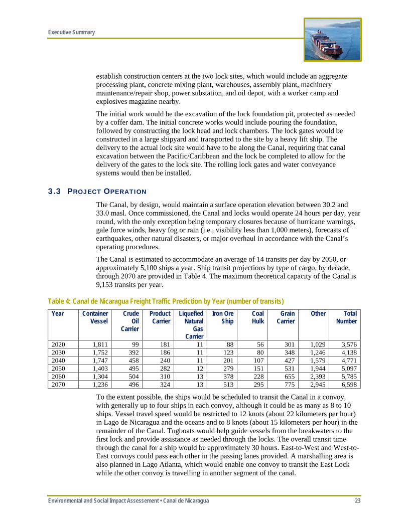
The Canal is estimated to accommodate an average of 14 transits per day by 2050, or approximately 5,100 ships a year. Ship transit projections by type of cargo, by decade, through 2070 are provided in Table 4. The maximum theoretical capacity of the Canal is 9,153 transits per year.
Table 4: Canal de Nicaragua Freight Traffic Prediction by Year (number of transits) Year Container
Vessel Crude
Oil Carrier
Product Carrier
Liquefied Natural
Gas Carrier
Iron Ore Ship
Coal Hulk
Grain Carrier
Other Total Number
2020 1,811 99 181 11 88 56 301 1,029 3,576 2030 1,752 392 186 11 123 80 348 1,246 4,138 2040 1,747 458 240 11 201 107 427 1,579 4,771 2050 1,403 495 282 12 279 151 531 1,944 5,097 2060 1,304 504 310 13 378 228 655 2,393 5,785 2070 1,236 496 324 13 513 295 775 2,945 6,598
To the extent possible, the ships would be scheduled to transit the Canal in a convoy, with generally up to four ships in each convoy, although it could be as many as 8 to 10 ships. Vessel travel speed would be restricted to 12 knots (about 22 kilometers per hour) in Lago de Nicaragua and the oceans and to 8 knots (about 15 kilometers per hour) in the remainder of the Canal. Tugboats would help guide vessels from the breakwaters to the first lock and provide assistance as needed through the locks. The overall transit time through the canal for a ship would be approximately 30 hours. East-to-West and West-to-East convoys could pass each other in the passing lanes provided. A marshalling area is also planned in Lago Atlanta, which would enable one convoy to transit the East Lock while the other convoy is travelling in another segment of the canal.

Executive Summary
24 Environmental and Social Impact Assessment • Canal de Nicaragua
Canal operations would require about 18 MW of electricity, primarily for lock operations (approximately 9 MW for each lock). This power would be secured from the Agua Zarca Hydropower Facility, which would provide an annual average of about 10 MW, supplemented by power from the Nicaraguan grid via transmission lines connecting the Brito Lock to the existing Rivas electrical substation and the Camilo Lock to the existing Corocito electrical substation. HKND would have backup diesel generators at each of the two locks to ensure reliable power in the event of a power outage.
The Brito and Camilo Locks would have a combined annual average daily water demand of 59.2 cubic meters per second, based on predicted vessel traffic in 2050 (14 transits per day), assuming the provision of three water saving basins per lock chamber. This does not include the release of flushing water for salinity management, which is one of several salinity management options.
Water balance modeling indicates that the Project design would have negligible effect on water levels in Lago de Nicaragua (i.e., no lowering of water levels). Water level must remain between elevations 30.2 meters and 33.0 meters for the Project to operate and water levels with the Project would closely replicate levels without the Project.
The Agua Zarca Reservoir, in addition to hydropower generation, would also provide supplemental water storage for use during the dry season and El Nino drought events. In general, HKND would manage water levels in the reservoir such that the reservoir is full (maximum water level) at the end of the rainy season. The Project’s water demand could increase depending on the selected method to control salinity intrusion.
HKND estimates its direct employment during operations would increase from approximately 3,700 employees in 2020 to about 12,700 employees in 2050 as the number of transits increases over time. It is anticipated that nearly all of these employees would be based in Nicaragua.
HKND would provide ferry service across the canal at the Acoyapa-San Carlos Road (Nicaragua Route 25) for vehicles, bicycles, and pedestrians. The ferries would be large enough to accommodate trucks and tractor trailers. The ferry service would be provided by HKND at no charge on a regular basis. This service would be provided indefinitely until alternative access across the Project is provided (e.g., a bridge).
The Project would require regular maintenance dredging, currently estimated by HKND at approximately 120,000 m3/yr. Dredged material from maintenance dredging would likely be placed in available capacity within the proposed ocean, upland, and CDF disposal locations.
3.4 HKND’S APPROVED EMBEDDED CONTROLS Embedded controls are physical or procedural measures that are planned as part of the Project design (i.e., not added solely based on a mitigation need identified by the impact assessment process). These embedded controls (see Appendix ES-B) represent commitments by HKND for inclusion in the Project design and were assumed to be in place as part of the Project design that formed the basis of the impact assessment.
Executive Summary
Environmental and Social Impact Assessement • Canal de Nicaragua 25
4 ESIA PROCESS AND STAKEHOLDER ENGAGEMENT
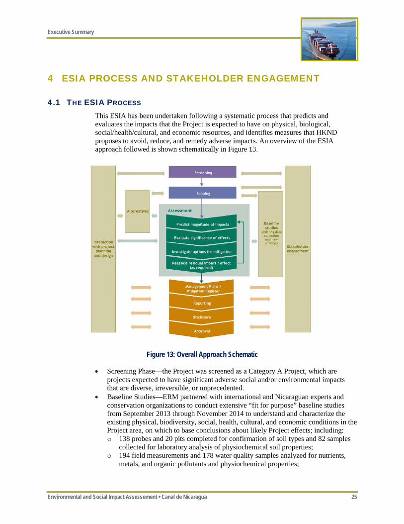
4.1 THE ESIA PROCESS This ESIA has been undertaken following a systematic process that predicts and evaluates the impacts that the Project is expected to have on physical, biological, social/health/cultural, and economic resources, and identifies measures that HKND proposes to avoid, reduce, and remedy adverse impacts. An overview of the ESIA approach followed is shown schematically in Figure 13.
Figure 13: Overall Approach Schematic
• Screening Phase—the Project was screened as a Category A Project, which are projects expected to have significant adverse social and/or environmental impacts that are diverse, irreversible, or unprecedented.
• Baseline Studies—ERM partnered with international and Nicaraguan experts and conservation organizations to conduct extensive “fit for purpose” baseline studies from September 2013 through November 2014 to understand and characterize the existing physical, biodiversity, social, health, cultural, and economic conditions in the Project area, on which to base conclusions about likely Project effects; including: o 138 probes and 20 pits completed for confirmation of soil types and 82 samples
collected for laboratory analysis of physiochemical soil properties; o 194 field measurements and 178 water quality samples analyzed for nutrients,
metals, and organic pollutants and physiochemical properties;
Executive Summary
26 Environmental and Social Impact Assessment • Canal de Nicaragua
o 69 sediment samples analyzed for nutrients, metals, organic pollutants, and grain size distribution;
o Over 100 freshwater biodiversity and physical habitat assessment points in Lago de Nicaragua and in the rivers sampled during the wet/dry seasons;
o 28 terrestrial biodiversity sampling hubs surveyed during the dry/wet seasons; o 152 marine benthos/vegetation and 458 marine plankton samples from 114
sampling stations, and over 23,350 square meters of subsea biological evaluation for corals;
o Direct observation of marine mammals and turtles covering over 800 kilometers and over 50 kilometers of potential shoreline nesting areas;
o Nine workshops with 475 participants in the eastern indigenous communities; o 1,940 households surveys (representing 9,324 people); and o 213 archaeological, 105 built heritage, and 12 living heritage sites located and
documented resulting in 15,723 archaeological artifacts collected and donated to the Instituto Nicaragüense de Cultura (INC).
• Scoping—the purpose of the scoping phase is to identify key issues facing the Project and to understand the concerns of stakeholders. Scoping meetings were conducted across the Project area and in Managua in July 2014, with approximately 5,000 persons attending. These scoping meetings helped inform the Terms of Reference for the Project, which were issued by MARENA in October 2014.
• Interaction with Design—during the ESIA process, there was extensive communication between HKND, CRCC, MEC, SBE (the three engineering consultants for the Project), and ERM with regard to optimizing the Project design to avoid/minimize impacts and to evaluate potential mitigation measures.
• Assessment of Impacts—the primary purpose of an ESIA is to predict the impacts resulting from a proposed Project. This ESIA considers: o Direct, indirect, induced, and cumulative impacts; o Full geographic length of the Project; o Project construction and operation; and o Embedded controls, which are measures that HKND has committed to and have
been incorporated into the Project design.
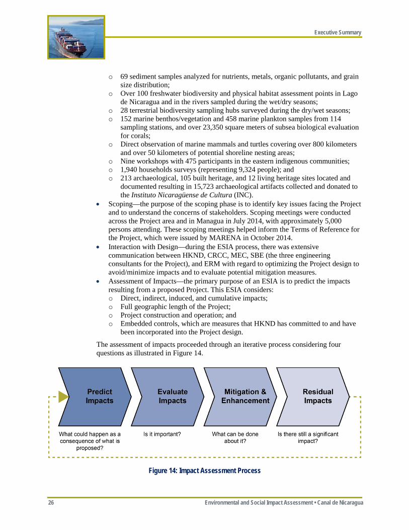
The assessment of impacts proceeded through an iterative process considering four questions as illustrated in Figure 14.
Figure 14: Impact Assessment Process
Executive Summary
Environmental and Social Impact Assessement • Canal de Nicaragua 27
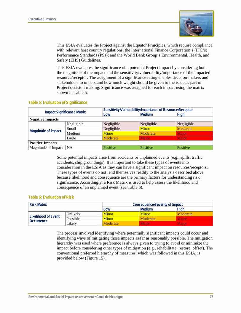
This ESIA evaluates the Project against the Equator Principles, which require compliance with relevant host country regulations; the International Finance Corporation’s (IFC’s) Performance Standards (PSs); and the World Bank Group’s Environmental, Health, and Safety (EHS) Guidelines.
This ESIA evaluates the significance of a potential Project impact by considering both the magnitude of the impact and the sensitivity/vulnerability/importance of the impacted resource/receptor. The assignment of a significance rating enables decision-makers and stakeholders to understand how much weight should be given to the issue as part of Project decision-making. Significance was assigned for each impact using the matrix shown in Table 5.
Table 5: Evaluation of Significance
Impact Significance Matrix Sensitivity/Vulnerability/Importance of Resource/Receptor Low Medium High
Negative Impacts
Magnitude of Impact
Negligible Negligible Negligible Negligible Small Negligible Minor Moderate Medium Minor Moderate Major Large Moderate Major Major
Positive Impacts Magnitude of Impact NA Positive Positive Positive
Some potential impacts arise from accidents or unplanned events (e.g., spills, traffic accidents, ship groundings). It is important to take these types of events into consideration in the ESIA as they can have a significant impact on resources/receptors. These types of events do not lend themselves readily to the analysis described above because likelihood and consequence are the primary factors for understanding risk significance. Accordingly, a Risk Matrix is used to help assess the likelihood and consequence of an unplanned event (see Table 6).
Table 6: Evaluation of Risk Risk Matrix Consequence/Severity of Impact
Low Medium High
Likelihood of Event Occurrence
Unlikely Minor Minor Moderate Possible Minor Moderate Major Likely Moderate Major Major
The process involved identifying where potentially significant impacts could occur and identifying ways of mitigating those impacts as far as reasonably possible. The mitigation hierarchy was used where preference is always given to trying to avoid or minimize the impact before considering other types of mitigation (e.g., rehabilitate, restore, offset). The conventional preferred hierarchy of measures, which was followed in this ESIA, is provided below (Figure 15).
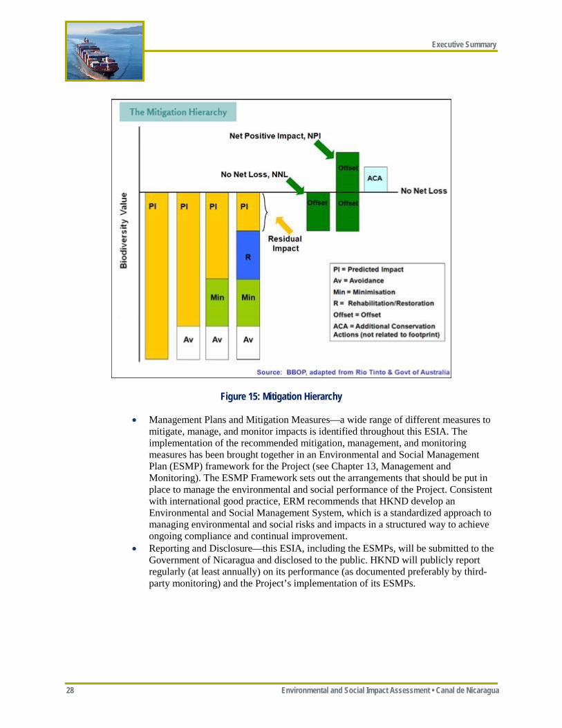
Executive Summary
28 Environmental and Social Impact Assessment • Canal de Nicaragua
Figure 15: Mitigation Hierarchy
• Management Plans and Mitigation Measures—a wide range of different measures to mitigate, manage, and monitor impacts is identified throughout this ESIA. The implementation of the recommended mitigation, management, and monitoring measures has been brought together in an Environmental and Social Management Plan (ESMP) framework for the Project (see Chapter 13, Management and Monitoring). The ESMP Framework sets out the arrangements that should be put in place to manage the environmental and social performance of the Project. Consistent with international good practice, ERM recommends that HKND develop an Environmental and Social Management System, which is a standardized approach to managing environmental and social risks and impacts in a structured way to achieve ongoing compliance and continual improvement.
• Reporting and Disclosure—this ESIA, including the ESMPs, will be submitted to the Government of Nicaragua and disclosed to the public. HKND will publicly report regularly (at least annually) on its performance (as documented preferably by third-party monitoring) and the Project’s implementation of its ESMPs.
Executive Summary
Environmental and Social Impact Assessement • Canal de Nicaragua 29
4.2 STAKEHOLDER ENGAGEMENT Stakeholder engagement refers to a process of sharing information and knowledge, seeking to understand the concerns of others, and building relationships based on collaboration and partnership. It is a long-term process that requires the building of trust through open dialogue and the delivery of commitments.
Several different methods were used to engage with stakeholders, including: • Scoping meetings—seven scoping
meetings were held across the Project area (i.e., Rivas, Ometepe, San Miguelito, Nueva Guinea, Polo de Desarrollo, Bluefields, and Managua) during July 2014 with approximately 5,000 attendees;
• Key informant interviews—over 130 key informant interviews were conducted with local experts with knowledge of the Project areas environmental, social, and economic conditions;
• Courtesy and informative meetings—over 20 courtesy and informative meetings were held with various organizations, primarily by HKND;
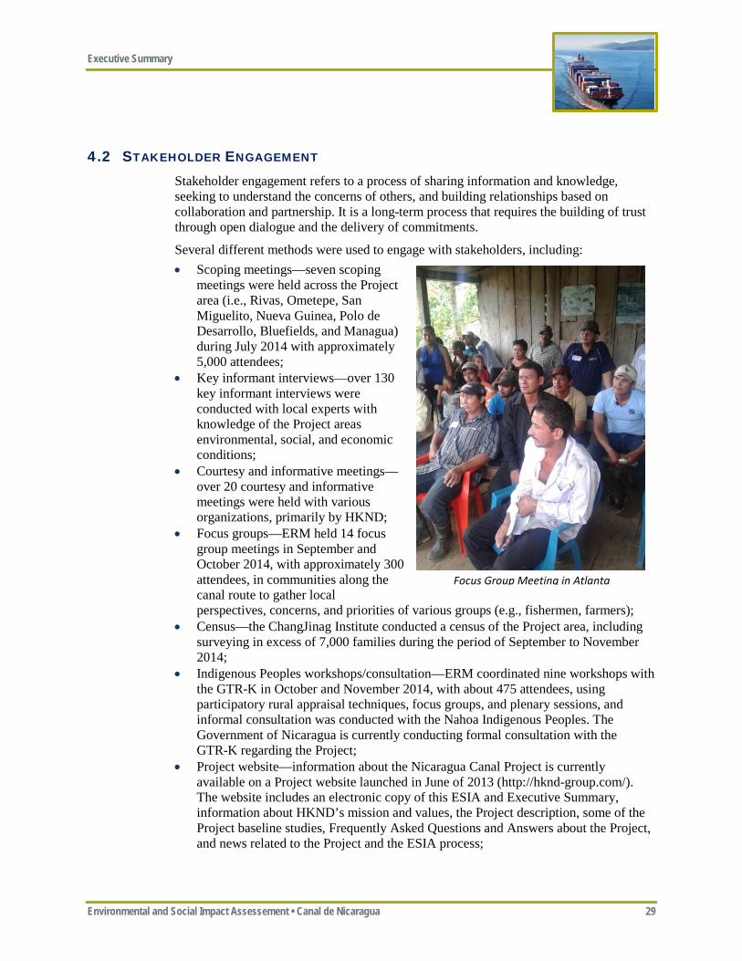
• Focus groups—ERM held 14 focus group meetings in September and October 2014, with approximately 300 attendees, in communities along the canal route to gather local perspectives, concerns, and priorities of various groups (e.g., fishermen, farmers);
• Census—the ChangJinag Institute conducted a census of the Project area, including surveying in excess of 7,000 families during the period of September to November 2014;
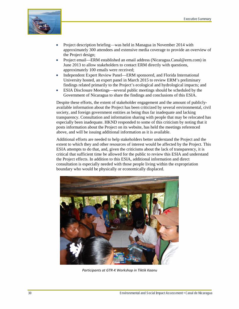
• Indigenous Peoples workshops/consultation—ERM coordinated nine workshops with the GTR-K in October and November 2014, with about 475 attendees, using participatory rural appraisal techniques, focus groups, and plenary sessions, and informal consultation was conducted with the Nahoa Indigenous Peoples. The Government of Nicaragua is currently conducting formal consultation with the GTR-K regarding the Project;
• Project website—information about the Nicaragua Canal Project is currently available on a Project website launched in June of 2013 (http://hknd-group.com/). The website includes an electronic copy of this ESIA and Executive Summary, information about HKND’s mission and values, the Project description, some of the Project baseline studies, Frequently Asked Questions and Answers about the Project, and news related to the Project and the ESIA process;
Focus Group Meeting in Atlanta
Executive Summary
30 Environmental and Social Impact Assessment • Canal de Nicaragua
• Project description briefing—was held in Managua in November 2014 with approximately 300 attendees and extensive media coverage to provide an overview of the Project design;
• Project email—ERM established an email address ([email protected]) in June 2013 to allow stakeholders to contact ERM directly with questions, approximately 100 emails were received;
• Independent Expert Review Panel—ERM sponsored, and Florida International University hosted, an expert panel in March 2015 to review ERM’s preliminary findings related primarily to the Project’s ecological and hydrological impacts; and
• ESIA Disclosure Meetings—several public meetings should be scheduled by the Government of Nicaragua to share the findings and conclusions of this ESIA.
Despite these efforts, the extent of stakeholder engagement and the amount of publicly-available information about the Project has been criticized by several environmental, civil society, and foreign government entities as being thus far inadequate and lacking transparency. Consultation and information sharing with people that may be relocated has especially been inadequate. HKND responded to some of this criticism by noting that it posts information about the Project on its website, has held the meetings referenced above, and will be issuing additional information as it is available.
Additional efforts are needed to help stakeholders better understand the Project and the extent to which they and other resources of interest would be affected by the Project. This ESIA attempts to do that, and, given the criticisms about the lack of transparency, it is critical that sufficient time be allowed for the public to review this ESIA and understand the Project effects. In addition to this ESIA, additional information and direct consultation is especially needed with those people living within the expropriation boundary who would be physically or economically displaced.
Participants at GTR-K Workshop in Tiktik Kaanu
Executive Summary
Environmental and Social Impact Assessement • Canal de Nicaragua 31
5 KEY ISSUES AND CONCERNS
The ESIA evaluates the effects of the Project on a wide range of resources and potential receptors, including: • Physical resources—including geology, soils, groundwater, surface water, air, noise,
and vibrations; • Biodiversity resources—including marine, freshwater, and terrestrial ecosystems; • Human resources—including social, community health, and cultural heritage; and • Economic resources—including economy and labor.
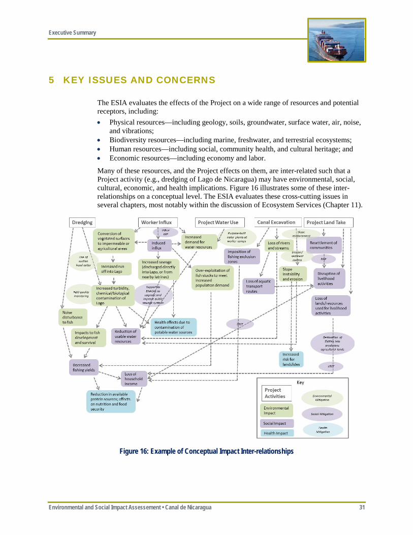
Many of these resources, and the Project effects on them, are inter-related such that a Project activity (e.g., dredging of Lago de Nicaragua) may have environmental, social, cultural, economic, and health implications. Figure 16 illustrates some of these inter-relationships on a conceptual level. The ESIA evaluates these cross-cutting issues in several chapters, most notably within the discussion of Ecosystem Services (Chapter 11).
Figure 16: Example of Conceptual Impact Inter-relationships
Executive Summary
32 Environmental and Social Impact Assessment • Canal de Nicaragua
This Executive Summary summarizes the findings of the ESIA relative to ten key issues raised about the Project during the scoping process, in the media, or through the independent impact assessment (Table 7). As expected, many of these ten key issues are inter-related and also touch on other Project impacts that are discussed in the ESIA, but not specifically listed below (e.g., climate change effects on Project water balance and Lago de Nicaragua; fugitive dust and noise effects on Project Affected Communities; vibration effects on Cultural Heritage). Except as noted below, HKND’s proposed embedded controls and ERM’s proposed mitigation measures are expected to adequately manage environmental and social risks associated with geology, hydrogeology, geomorphology, soils, air quality, noise, and vibration. The potential for accidents and natural hazards are discussed below under Key Issues #1 (Lago de Nicaragua) and #9 (Natural Hazards and Project Safety), but are discussed more broadly in Chapter 10 of the ESIA. Effects on ecosystem services and Project-related cumulative impacts are discussed in Chapters 11 and 12 of the ESIA, respectively.
Table 7: Key Issues and Concerns
Key Issues or Concerns Relevant International Standard
Related ESAP Action Items
ESIA Chapter References
1. Lago de Nicaragua IFC PS 3/WB EHS #8, 10, 11, 12, 13, 19, 20, 21 5, 6, 7, 11, 12
2. Soil Erosion and Sedimentation IFC PS 3/WB EHS # 19, 20, 21 5, 6, 7, 11, 12
3. Biodiversity IFC PS 6 #6, 13, 14, 15, 18, 19 20, 21 5, 7, 11, 12
4. Land Expropriation/Resettlement IFC PS 5 #3, 7, 19, 20, 21 5, 8 5. Indigenous Peoples IFC PS 7 #4, 7, 19, 20, 21 5, 8, 12 6. Project Affected Communities IFC PS 1 #5, 7, 19, 20, 21 5, 8, 12 7. Influx and Induced Impacts IFC Handbook #7, 18, 19, 20, 21 5, 7, 8, 12 8. Cultural Heritage IFC PS 8 #12, 20, 21 5, 8, 11, 12 9. Natural Hazards and Project Safety IFC PS 4 #8, 9, 14, 16, 17 ,20, 23 10 10. Trans-boundary Effects IFC PS 1/3 #20, 21 6, 7
For each of these 10 key issues, this Executive Summary describes the Project effects, discusses the management and mitigation measures that HKND proposes or has accepted, references applicable international standards, and explains ERM conclusions and recommendations. ERM applied the Precautionary Principle where risks were high.
ERM has prepared an ESAP that lists the key actions needed to be completed by HKND in order to allow for adequate stakeholder engagement, meet international standards, and provide the information needed for the Government of Nicaragua to make an informed decision regarding the merits of the Project (see Appendix ES-A).
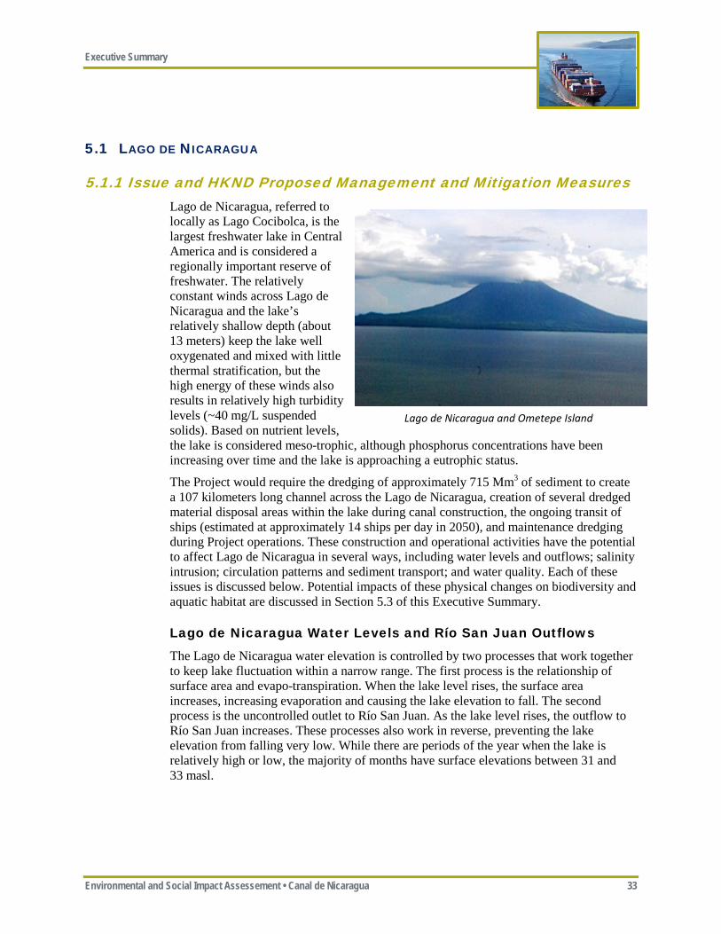
Executive Summary
Environmental and Social Impact Assessement • Canal de Nicaragua 33
5.1 LAGO DE NICARAGUA
5.1.1 Issue and HKND Proposed Management and Mitigation Measures Lago de Nicaragua, referred to locally as Lago Cocibolca, is the largest freshwater lake in Central America and is considered a regionally important reserve of freshwater. The relatively constant winds across Lago de Nicaragua and the lake’s relatively shallow depth (about 13 meters) keep the lake well oxygenated and mixed with little thermal stratification, but the high energy of these winds also results in relatively high turbidity levels (~40 mg/L suspended solids). Based on nutrient levels, the lake is considered meso-trophic, although phosphorus concentrations have been increasing over time and the lake is approaching a eutrophic status.
The Project would require the dredging of approximately 715 Mm3 of sediment to create a 107 kilometers long channel across the Lago de Nicaragua, creation of several dredged material disposal areas within the lake during canal construction, the ongoing transit of ships (estimated at approximately 14 ships per day in 2050), and maintenance dredging during Project operations. These construction and operational activities have the potential to affect Lago de Nicaragua in several ways, including water levels and outflows; salinity intrusion; circulation patterns and sediment transport; and water quality. Each of these issues is discussed below. Potential impacts of these physical changes on biodiversity and aquatic habitat are discussed in Section 5.3 of this Executive Summary.
Lago de Nicaragua Water Levels and Río San Juan Outflows
The Lago de Nicaragua water elevation is controlled by two processes that work together to keep lake fluctuation within a narrow range. The first process is the relationship of surface area and evapo-transpiration. When the lake level rises, the surface area increases, increasing evaporation and causing the lake elevation to fall. The second process is the uncontrolled outlet to Río San Juan. As the lake level rises, the outflow to Río San Juan increases. These processes also work in reverse, preventing the lake elevation from falling very low. While there are periods of the year when the lake is relatively high or low, the majority of months have surface elevations between 31 and 33 masl.
Lago de Nicaragua and Ometepe Island
Executive Summary
34 Environmental and Social Impact Assessment • Canal de Nicaragua
The Project has been designed to operate at the same water level as the Lago de Nicaragua (between 30.2 and 33.0 masl) and to have no net use of water from Lago de Nicaragua; instead water from the Río Punta Gorda would be used to operate the canal. The average flow in the Río Punta Gorda (approximately, 111 m3/second) is greater than the Project’s water demand (approximately 56 m3/second in 2050—without any salinity control). Since the canal between the Brito and Camilo locks would essentially be an extension of Lago de Nicaragua at the same water elevation, HKND would use the Camilo Lock as a dam behind which to store excess flow from the Río Punta Gorda during the rainy season. Some of this excess flow would back up and ultimately be stored in Lago de Nicaragua, resulting in a somewhat counter-intuitive conclusion that the Project would result in a slight (approximately 12 cm) increase in lake water levels (at least during the rainy season), rather than a decrease in water levels. Storing excess water in Lago de Nicaragua, however, is not ideal, as much of it can be lost to evapo-transpiration and Río San Juan outflow.
The water modeling by CRCC and SBE/Deltares indicate that during extreme dry periods (e.g., during consecutive El Nino years) there may not be sufficient water in the Río Punta Gorda to operate the canal. HKND proposes to use the Agua Zarca Reservoir to provide supplementary water to allow the Project to operate without using Lago de Nicaragua water. Since the Project would not significantly influence water levels in Lago de Nicaragua, it should have negligible effect on outflows into the Río San Juan.
Water availability is a critical concern for the Project, particularly with the uncertainties associated with climate change. ERM recommends that updated modeling be conducted using more accurate data and making daily predictions to increase the confidence in these preliminary estimates. This updated modeling should take into consideration updated lakeshore remote sensing shoreline topography, lake bathymetry, potential evapo-transpiration estimates, future non-Project water demands, reservoir water storage (e.g., Agua Zarca), proposed salinity management measures, current lock design, potential changes in Río Punta Gorda watershed hydrology, the lower Río Punta Gorda ecological flows, and climate change to confirm that sufficient water supply is available for Project operations without impacting water levels in Lago de Nicaragua.
Salinity Intrusion
The Project would allow ships to pass from salt water (either the Pacific Ocean or the Caribbean Sea), through Lago de Nicaragua (freshwater), and back to salt water. As these ships pass through the Brito and Camilo Locks, some salt water would transfer through the locks along with the ships and has the potential to reach Lago de Nicaragua. Lago de Nicaragua is considered a drinking water source; therefore, the salinity in Lago de Nicaragua needs to meet drinking water standards. Nicaragua does not have a water quality standard for “salinity;” but chloride can be used as a surrogate for salinity, with a drinking water standard of 250 mg/L.
The future 2070 scenario was modeled in order to examine the post-construction salinity regime—assuming no salinity control measures at the locks since the exact measures have not yet been selected. ERM has estimated the 2070 volume-averaged chloride concentration in Lago de Nicaragua would increase from approximately 64 mg/L to approximately 160 mg/L (0.5 parts per thousand [ppt] salinity).
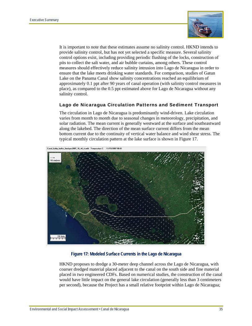
Executive Summary
Environmental and Social Impact Assessement • Canal de Nicaragua 35
It is important to note that these estimates assume no salinity control. HKND intends to provide salinity control, but has not yet selected a specific measure. Several salinity control options exist, including providing periodic flushing of the locks, construction of pits to collect the salt water, and air bubble curtains, among others. These control measures should effectively reduce salinity intrusion into Lago de Nicaragua in order to ensure that the lake meets drinking water standards. For comparison, studies of Gatun Lake on the Panama Canal show salinity concentrations reached an equilibrium of approximately 0.1 ppt after 90 years of canal operation (with salinity control measures in place), as compared to the 0.5 ppt estimated above for Lago de Nicaragua without any salinity control.
Lago de Nicaragua Circulation Patterns and Sediment Transport
The circulation in Lago de Nicaragua is predominantly wind-driven. Lake circulation varies from month to month due to seasonal changes in meteorology, precipitation, and solar radiation. The mean current is generally westward at the surface and southeastward along the lakebed. The direction of the mean surface current differs from the mean bottom current due to the continuity of vertical water balance and wind shear stress. The typical monthly circulation pattern at the lake surface is shown in Figure 17.
Figure 17: Modeled Surface Currents in the Lago de Nicaragua
HKND proposes to dredge a 30-meter deep channel across the Lago de Nicaragua, with coarser dredged material placed adjacent to the canal on the south side and fine material placed in two engineered CDFs. Based on numerical studies, the construction of the canal would have little impact on the general lake circulation (generally less than 3 centimeters per second), because the Project has a small relative footprint within Lago de Nicaragua;
Executive Summary
36 Environmental and Social Impact Assessment • Canal de Nicaragua
the largest effects are seen adjacent to the canal entrance, inside the canal, and around the CDFs.
Studies indicate that most of the sediment load reaching Lago de Nicaragua is coming from Costa Rica to the south. Based on the southeastward bottom currents, most of this bedload sediment would be expected to move toward the lake’s Río San Juan outlet, and would not be expected to reach the canal channel. Bedload sediment crossing the canal path from the north would settle in the channel and would trigger the need for regular maintenance dredging of the canal. Suspended sediments coming from the north or south would be driven by the prevailing westerly currents, but should not be affected by canal dredging. Prop wash from ships transiting the channel may re-suspend some sediment, but the impacts are expected to be within the channel cut.
Lago de Nicaragua Water Quality
The Project has the potential to affect water quality in Lago de Nicaragua in several ways, each of which is discussed below: • re-mobilizing contaminants currently sequestered in lake sediments during initial and
subsequent maintenance dredging; • changing the nutrient dynamics of the lake by remobilizing some nutrients currently
sequestered in lake sediments and introducing additional nutrient load via the Project connection with the Río Punta Gorda, which collectively could also affect dissolved oxygen levels in the lake; and
• the potential for accidents and spills from ships transiting the canal.
Re-mobilizing Contaminants
Sediment sampling in Lago de Nicaragua found several contaminants exceeded water quality screening concentrations (primarily arsenic and mercury [see Table 8] and chlordane epoxide [a pesticide]). These contaminants are typically more associated with upper fine sediments than deeper or coarser sediments.
Table 8: Metals Detected in Lago de Nicaragua Sediment
Metal Average
Concentration Max Concentration Guidelines SQuiRT Guidelines SQuiRT Exceedances
mg/kg mg/kg mg/kg Number Chromium total 7.7 15.0 7-13 2 Manganese total 438.5 1049.0 400 7 Nickel total 6.7 15.0 9.9 4 Copper total 24.47 45.86 10-25 6 Iron total 13,205.65 32,150.4 9,900-18,000 2 Aluminum total 3,499.8 6,935.4 2,600 8 Arsenic total 37.65 94.92 1.1 14 Cadmium total 0.26 0.67 0.1-0.3 8 Selenium total 0.124 0.540 0.29 2 Mercury total 0.137 0.600 0.004-0.051 14
mg/kg = milligrams/kilogram; SQuiRT = US National Oceanic and Atmospheric Administration’s Screening Quick Reference Tables
Executive Summary
Environmental and Social Impact Assessement • Canal de Nicaragua 37
Dredging can mobilize pesticides or metals that have been sequestered in sediments, which can then be dispersed in the Lago de Nicaragua by currents. In order to minimize the dispersion of these fine metal/pesticide-laden sediments, HKND proposes to use a cutter suction dredge that would hydraulically “vacuum” these fine sediments, place them in an attached trailer hopper, and transport this material to a CDF for final disposal. The deeper coarser heavier sediments with less contamination and less potential for dispersion would be placed adjacent to the canal on the south side.
ERM prepared a steady state partitioning theory analysis for arsenic, mercury, and chlordane epoxide to compute whether their release would exceed background water column concentrations and World Health Organization (WHO) drinking water standards. The analysis indicates that the release of mercury and chlordane from these sediments would be minor, localized and would not exceed drinking water standards. Arsenic concentrations already exceed drinking water standards, but the Project is predicted to have negligible effect on background concentrations.
Additional borings of lake sediments is needed to confirm the sediments chemical and physical properties and overall stratigraphy (i.e., the distribution with depth of fine versus coarse sediments). These borings are needed to confirm the appropriateness of the current dredge material disposal strategy (e.g., if more fine sediments are present then the CDFs would need to be enlarged).
Changing Nutrient Dynamics
Dredging of the channel could re-mobilize nutrients and organic material in the sediments, just as it could do for metals and pesticides. This raises the concern that these nutrients and organic material could increase the biochemical oxygen demand and eutrophication potential, eventually leading to hypoxia (reduced oxygen levels) and fish kills in Lago de Nicaragua. Similarly, connecting the Río Punta Gorda to Lago de Nicaragua would introduce a new source of nutrients to Lago de Nicaragua.
Given the relatively high level of wind-induced mixing in the lake, oxygenation and reaeration of lake water is very active and serves to maintain high levels of oxygen throughout the lake. Sediment plumes near dredging activities could result in short term and localized impacts to water quality and dissolved oxygen.
Similarly, by connecting the Río Punta Gorda to Lago de Nicaragua, the Project would introduce a new source of nutrients that would increase the phosphorus and nitrogen concentration in the lake by less than10 percent. In this respect, the Project could accelerate the lake’s existing transformation from a mesotrophic to a eutrophic status depending on ambient conditions.
Potential for Accidents and Spills
There is always the potential for unplanned events (e.g., accidents and spills) associated with any infrastructure project. Unplanned events are evaluated differently in this ESIA from other types of impacts that may occur since these events are not planned or predictable. For unplanned events, ERM considered the likelihood of the event occurring and the severity/consequence of the impacts resulting from the event. Some of the most significant unplanned events are associated with the potential for oil or hazardous material spills in Lago de Nicaragua.
Executive Summary
38 Environmental and Social Impact Assessment • Canal de Nicaragua
All vessels transiting the canal would be required to meet current MARPOL convention for the Safe Operations of Ships and for Pollution Prevention, whose objectives are to ensure safety, prevent human injury or loss of life, and avoid damage to the environment.
The Project would be operated essentially with one-way traffic. A ship would only pass another ship in two designated passing areas (one in Lago de Nicaragua and one in Lago Atlanta) where the other ship would be stationary; therefore, the risk of ship collisions in Lago de Nicaragua is considered small. HKND would restrict Project operations during extreme weather conditions to minimize the risk of groundings and other accidents. Further, essentially all oil tankers are required to have double hulls and Lago de Nicaragua has deep soft sediments along the proposed channel, which reduce the risk of spills from groundings. Vessels transiting the canal would be closely monitored through a Vessel Traffic Management System that uses radar and other technologies to track and monitor ships and manage traffic situations to ensure navigation safety.
Despite these measures, accidents and spills could still occur from leaks and operator error, but would likely be of less severity and smaller volumes. The experience at the Panama Canal demonstrates that canals can be operated relatively safely. Nevertheless, Lago de Nicaragua is a critically valuable water resource, and HKND would need to demonstrate a strong commitment to safety and establish a robust emergency action plan.
5.1.2 International Standard IFC Performance Standard 3 (PS 3) (Resource Efficiency and Pollution Prevention) and the WBG EHS Guidelines establish good international practice relative to water resources and use. Project sponsors are expected to avoid, or minimize and control, the release of pollutants, as well as adopt measures that avoid or reduce water usage so that the Project’s water consumption does not have significant adverse effects on others.
5.1.3 ERM Conclusions and Recommendations Preliminary studies indicate that the Project would have small effects on Lago de Nicaragua water levels and should be able to adequately manage the potential for salinity impacts at the two locks. HKND has proposed measures consistent with international good practice relative to dredging and dredged material management in Lago de Nicaragua. ERM recommends the following actions: • HKND should identify the specific salinity mitigation measures it would propose and
re-evaluate the potential for salinity impacts ; • HKND should prepare an updated and more comprehensive water balance to confirm
the results of the preliminary studies and the adequacy of water supply for Project operations without impacting water levels in Lago de Nicaragua;
• HKND should implement a robust Lago de Nicaragua Management Plan and an East Canal Watershed Management Plan to reduce sediment and nutrient loading from reaching Lago de Nicaragua;
• HKND should develop a detailed Operations and Emergency Response Plan, which reflect lessons learned from the Panama and Suez canals, and should be reviewed by international safety experts to ensure safe navigation through the canal; and
• HKND should provide spill control equipment near Lago de Nicaragua to allow for quick response to any spills and conduct routine training exercises.
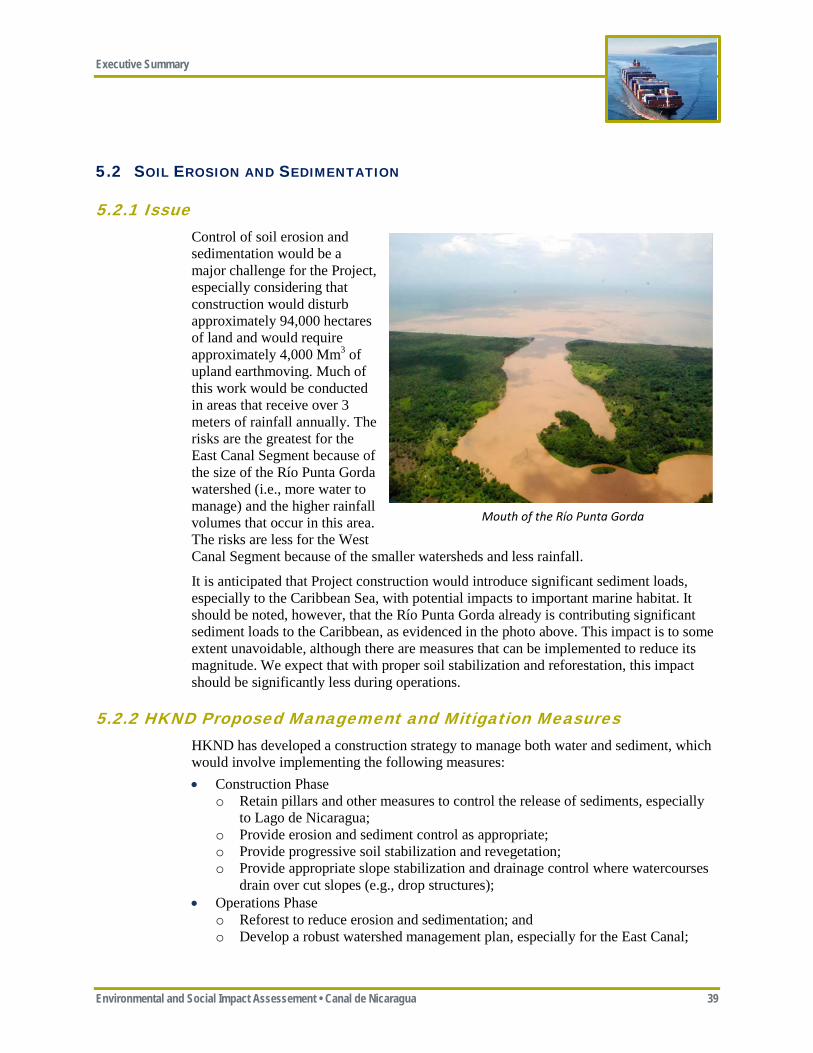
Executive Summary
Environmental and Social Impact Assessement • Canal de Nicaragua 39
5.2 SOIL EROSION AND SEDIMENTATION
5.2.1 Issue Control of soil erosion and sedimentation would be a major challenge for the Project, especially considering that construction would disturb approximately 94,000 hectares of land and would require approximately 4,000 Mm3 of upland earthmoving. Much of this work would be conducted in areas that receive over 3 meters of rainfall annually. The risks are the greatest for the East Canal Segment because of the size of the Río Punta Gorda watershed (i.e., more water to manage) and the higher rainfall volumes that occur in this area. The risks are less for the West Canal Segment because of the smaller watersheds and less rainfall.
It is anticipated that Project construction would introduce significant sediment loads, especially to the Caribbean Sea, with potential impacts to important marine habitat. It should be noted, however, that the Río Punta Gorda already is contributing significant sediment loads to the Caribbean, as evidenced in the photo above. This impact is to some extent unavoidable, although there are measures that can be implemented to reduce its magnitude. We expect that with proper soil stabilization and reforestation, this impact should be significantly less during operations.
5.2.2 HKND Proposed Management and Mitigation Measures HKND has developed a construction strategy to manage both water and sediment, which would involve implementing the following measures: • Construction Phase
o Retain pillars and other measures to control the release of sediments, especially to Lago de Nicaragua;
o Provide erosion and sediment control as appropriate; o Provide progressive soil stabilization and revegetation; o Provide appropriate slope stabilization and drainage control where watercourses
drain over cut slopes (e.g., drop structures); • Operations Phase
o Reforest to reduce erosion and sedimentation; and o Develop a robust watershed management plan, especially for the East Canal;
Mouth of the Río Punta Gorda
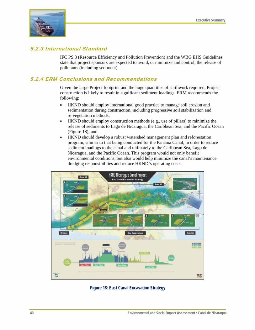
Executive Summary
40 Environmental and Social Impact Assessment • Canal de Nicaragua
5.2.3 International Standard IFC PS 3 (Resource Efficiency and Pollution Prevention) and the WBG EHS Guidelines state that project sponsors are expected to avoid, or minimize and control, the release of pollutants (including sediment).
5.2.4 ERM Conclusions and Recommendations Given the large Project footprint and the huge quantities of earthwork required, Project construction is likely to result in significant sediment loadings. ERM recommends the following: • HKND should employ international good practice to manage soil erosion and
sedimentation during construction, including progressive soil stabilization and re-vegetation methods;
• HKND should employ construction methods (e.g., use of pillars) to minimize the release of sediments to Lago de Nicaragua, the Caribbean Sea, and the Pacific Ocean (Figure 18); and
• HKND should develop a robust watershed management plan and reforestation program, similar to that being conducted for the Panama Canal, in order to reduce sediment loadings to the canal and ultimately to the Caribbean Sea, Lago de Nicaragua, and the Pacific Ocean. This program would not only benefit environmental conditions, but also would help minimize the canal’s maintenance dredging responsibilities and reduce HKND’s operating costs.
Figure 18: East Canal Excavation Strategy
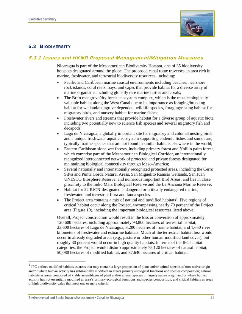
Executive Summary
Environmental and Social Impact Assessement • Canal de Nicaragua 41
5.3 BIODIVERSITY
5.3.1 Issues and HKND Proposed Management/Mitigation Measures Nicaragua is part of the Mesoamerican Biodiversity Hotspot, one of 35 biodiversity hotspots designated around the globe. The proposed canal route traverses an area rich in marine, freshwater, and terrestrial biodiversity resources, including: • Pacific and Caribbean marine coastal environments including beaches, nearshore
rock islands, coral reefs, bays, and capes that provide habitat for a diverse array of marine organisms including globally rare marine turtles and corals;
• The Brito mangrove/dry forest ecosystem complex, which is the most ecologically valuable habitat along the West Canal due to its importance as foraging/breeding habitat for wetland/mangrove dependent wildlife species, foraging/resting habitat for migratory birds, and nursery habitat for marine fishes;
• Freshwater rivers and streams that provide habitat for a diverse group of aquatic biota including two potentially new to science fish species and several migratory fish and decapods;
• Lago de Nicaragua, a globally important site for migratory and colonial nesting birds and a unique freshwater aquatic ecosystem supporting endemic fishes and some rare, typically marine species that are not found in similar habitats elsewhere in the world;
• Eastern Caribbean slope wet forests, including primary forest and Yolillo palm forest, which comprise part of the Mesoamerican Biological Corridor, an internationally recognized interconnected network of protected and private forests designated for maintaining biological connectivity through Meso-America;
• Several nationally and internationally recognized protected areas, including the Cerro Silva and Punta Gorda Natural Areas, San Miguelito Ramsar wetlands, San Juan UNESCO Biosphere Reserve, and numerous Important Bird Areas, and lies in close proximity to the Indio Maiz Biological Reserve and the La Anciana Marine Reserve;
• Habitat for 22 IUCN-designated endangered or critically endangered marine, freshwater, and terrestrial flora and fauna species.
• The Project area contains a mix of natural and modified habitats1. Five regions of critical habitat occur along the Project, encompassing nearly 70 percent of the Project area (Figure 19), including the important biological resources listed above.
Overall, Project construction would result in the loss or conversion of approximately 120,600 hectares, including approximately 93,800 hectares of terrestrial habitat, 23,600 hectares of Lago de Nicaragua, 3,200 hectares of marine habitat, and 1,650 river kilometers of freshwater and estuarine habitats. Much of the terrestrial habitat loss would occur in already degraded areas (e.g., pasture or other human-modified land cover), but roughly 30 percent would occur in high quality habitats. In terms of the IFC habitat categories, the Project would disturb approximately 75,120 hectares of natural habitat, 50,080 hectares of modified habitat, and 87,640 hectares of critical habitat.
1 IFC defines modified habitats as areas that may contain a large proportion of plant and/or animal species of non-native origin and/or where human activity has substantially modified an area’s primary ecological functions and species composition; natural habitats as areas composed of viable assemblages of plant and/or animal species of largely native origin and/or where human activity has not essentially modified an area’s primary ecological functions and species composition, and critical habitats as areas of high biodiversity value that meet one or more criteria.
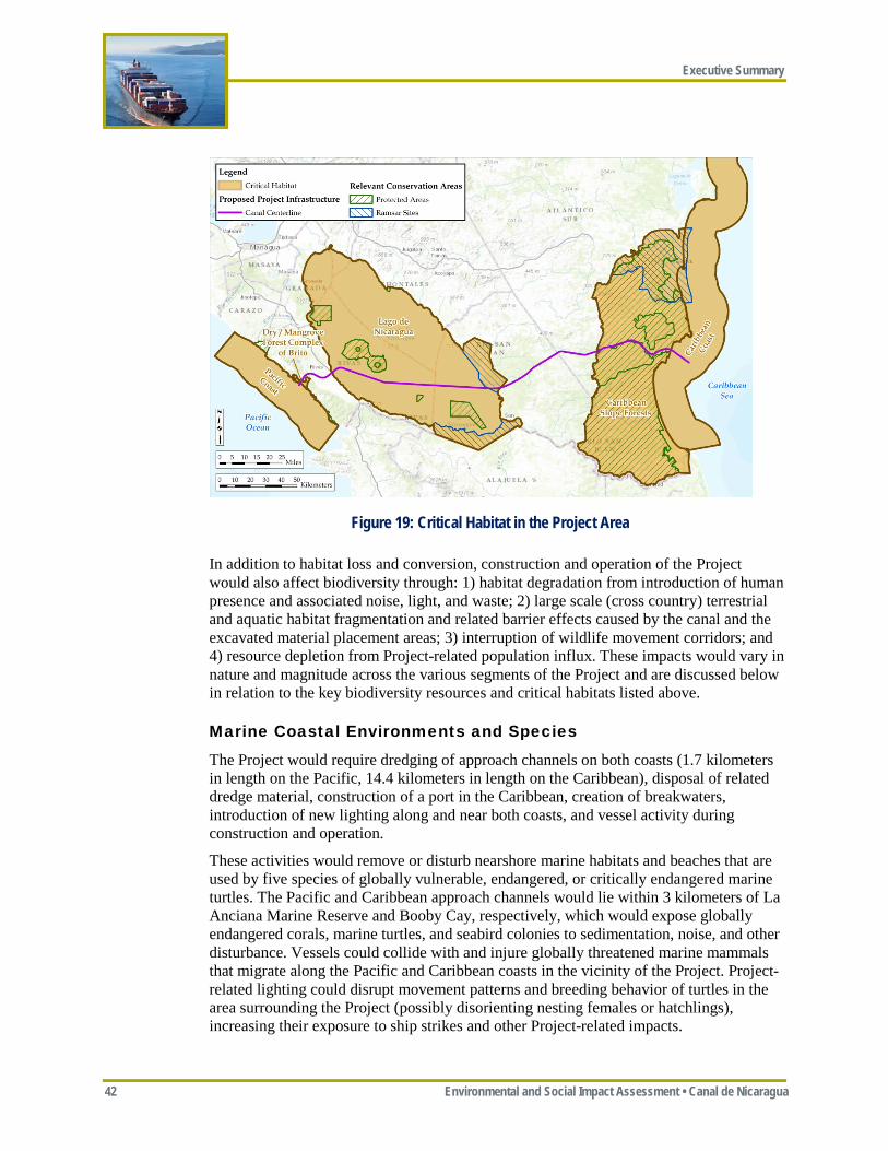
Executive Summary
42 Environmental and Social Impact Assessment • Canal de Nicaragua
In addition to habitat loss and conversion, construction and operation of the Project would also affect biodiversity through: 1) habitat degradation from introduction of human presence and associated noise, light, and waste; 2) large scale (cross country) terrestrial and aquatic habitat fragmentation and related barrier effects caused by the canal and the excavated material placement areas; 3) interruption of wildlife movement corridors; and 4) resource depletion from Project-related population influx. These impacts would vary in nature and magnitude across the various segments of the Project and are discussed below in relation to the key biodiversity resources and critical habitats listed above.
Marine Coastal Environments and Species
The Project would require dredging of approach channels on both coasts (1.7 kilometers in length on the Pacific, 14.4 kilometers in length on the Caribbean), disposal of related dredge material, construction of a port in the Caribbean, creation of breakwaters, introduction of new lighting along and near both coasts, and vessel activity during construction and operation.
These activities would remove or disturb nearshore marine habitats and beaches that are used by five species of globally vulnerable, endangered, or critically endangered marine turtles. The Pacific and Caribbean approach channels would lie within 3 kilometers of La Anciana Marine Reserve and Booby Cay, respectively, which would expose globally endangered corals, marine turtles, and seabird colonies to sedimentation, noise, and other disturbance. Vessels could collide with and injure globally threatened marine mammals that migrate along the Pacific and Caribbean coasts in the vicinity of the Project. Project-related lighting could disrupt movement patterns and breeding behavior of turtles in the area surrounding the Project (possibly disorienting nesting females or hatchlings), increasing their exposure to ship strikes and other Project-related impacts.
Figure 19: Critical Habitat in the Project Area
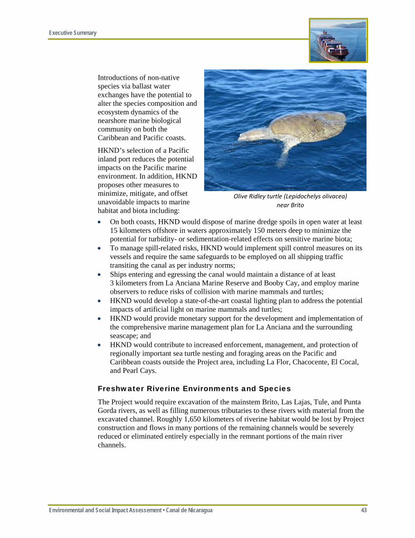
Executive Summary
Environmental and Social Impact Assessement • Canal de Nicaragua 43
Introductions of non-native species via ballast water exchanges have the potential to alter the species composition and ecosystem dynamics of the nearshore marine biological community on both the Caribbean and Pacific coasts.
HKND’s selection of a Pacific inland port reduces the potential impacts on the Pacific marine environment. In addition, HKND proposes other measures to minimize, mitigate, and offset unavoidable impacts to marine habitat and biota including: • On both coasts, HKND would dispose of marine dredge spoils in open water at least
15 kilometers offshore in waters approximately 150 meters deep to minimize the potential for turbidity- or sedimentation-related effects on sensitive marine biota;
• To manage spill-related risks, HKND would implement spill control measures on its vessels and require the same safeguards to be employed on all shipping traffic transiting the canal as per industry norms;
• Ships entering and egressing the canal would maintain a distance of at least 3 kilometers from La Anciana Marine Reserve and Booby Cay, and employ marine observers to reduce risks of collision with marine mammals and turtles;
• HKND would develop a state-of-the-art coastal lighting plan to address the potential impacts of artificial light on marine mammals and turtles;
• HKND would provide monetary support for the development and implementation of the comprehensive marine management plan for La Anciana and the surrounding seascape; and
• HKND would contribute to increased enforcement, management, and protection of regionally important sea turtle nesting and foraging areas on the Pacific and Caribbean coasts outside the Project area, including La Flor, Chacocente, El Cocal, and Pearl Cays.
Freshwater Riverine Environments and Species
The Project would require excavation of the mainstem Brito, Las Lajas, Tule, and Punta Gorda rivers, as well as filling numerous tributaries to these rivers with material from the excavated channel. Roughly 1,650 kilometers of riverine habitat would be lost by Project construction and flows in many portions of the remaining channels would be severely reduced or eliminated entirely especially in the remnant portions of the main river channels.
Olive Ridley turtle (Lepidochelys olivacea) near Brito
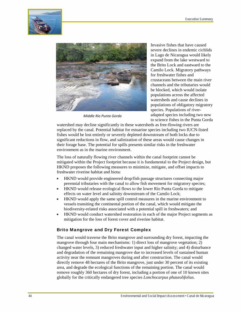
Executive Summary
44 Environmental and Social Impact Assessment • Canal de Nicaragua
Invasive fishes that have caused severe declines in endemic cichlids in Lago de Nicaragua would likely expand from the lake westward to the Brito Lock and eastward to the Camilo Lock. Migratory pathways for freshwater fishes and crustaceans between the main river channels and the tributaries would be blocked, which would isolate populations across the affected watersheds and cause declines in populations of obligatory migratory species. Populations of river-adapted species including two new to science fishes in the Punta Gorda
watershed may decline significantly in these watersheds as free-flowing rivers are replaced by the canal. Potential habitat for estuarine species including two IUCN-listed fishes would be lost entirely or severely depleted downstream of both locks due to significant reductions in flow, and salinization of these areas would cause changes in their forage base. The potential for spills presents similar risks in the freshwater environment as in the marine environment.
The loss of naturally flowing river channels within the canal footprint cannot be mitigated within the Project footprint because it is fundamental to the Project design, but HKND proposes the following measures to minimize, mitigate, and offset impacts to freshwater riverine habitat and biota: • HKND would provide engineered drop/fish passage structures connecting major
perennial tributaries with the canal to allow fish movement for migratory species; • HKND would release ecological flows to the lower Río Punta Gorda to mitigate
effects on water level and salinity downstream of the Camilo Lock; • HKND would apply the same spill control measures in the marine environment to
vessels transiting the continental portion of the canal, which would mitigate the biodiversity-related risks associated with a potential spill in freshwaters; and
• HKND would conduct watershed restoration in each of the major Project segments as mitigation for the loss of forest cover and riverine habitat.
Brito Mangrove and Dry Forest Complex
The canal would traverse the Brito mangrove and surrounding dry forest, impacting the mangrove through four main mechanisms: 1) direct loss of mangrove vegetation; 2) changed water levels, 3) reduced freshwater input and higher salinity; and 4) disturbance and degradation of the remaining mangrove due to increased levels of sustained human activity near the remnant mangroves during and after construction. The canal would directly remove 48 hectares of the Brito mangrove, just under 30 percent of its existing area, and degrade the ecological functions of the remaining portion. The canal would remove roughly 360 hectares of dry forest, including a portion of one of 10 known sites globally for the critically endangered tree species Lonchocarpus phaseolifolius.
Middle Río Punta Gorda
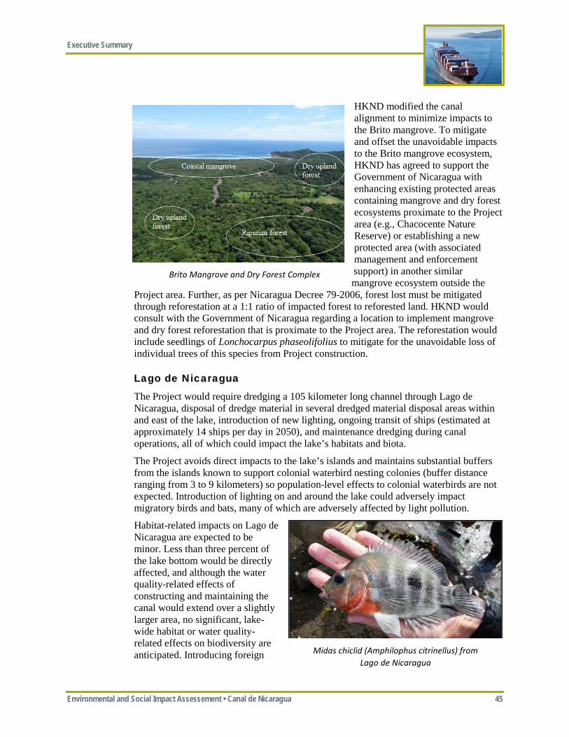
Executive Summary
Environmental and Social Impact Assessement • Canal de Nicaragua 45
HKND modified the canal alignment to minimize impacts to the Brito mangrove. To mitigate and offset the unavoidable impacts to the Brito mangrove ecosystem, HKND has agreed to support the Government of Nicaragua with enhancing existing protected areas containing mangrove and dry forest ecosystems proximate to the Project area (e.g., Chacocente Nature Reserve) or establishing a new protected area (with associated management and enforcement support) in another similar mangrove ecosystem outside the
Project area. Further, as per Nicaragua Decree 79-2006, forest lost must be mitigated through reforestation at a 1:1 ratio of impacted forest to reforested land. HKND would consult with the Government of Nicaragua regarding a location to implement mangrove and dry forest reforestation that is proximate to the Project area. The reforestation would include seedlings of Lonchocarpus phaseolifolius to mitigate for the unavoidable loss of individual trees of this species from Project construction.
Lago de Nicaragua
The Project would require dredging a 105 kilometer long channel through Lago de Nicaragua, disposal of dredge material in several dredged material disposal areas within and east of the lake, introduction of new lighting, ongoing transit of ships (estimated at approximately 14 ships per day in 2050), and maintenance dredging during canal operations, all of which could impact the lake’s habitats and biota.
The Project avoids direct impacts to the lake’s islands and maintains substantial buffers from the islands known to support colonial waterbird nesting colonies (buffer distance ranging from 3 to 9 kilometers) so population-level effects to colonial waterbirds are not expected. Introduction of lighting on and around the lake could adversely impact migratory birds and bats, many of which are adversely affected by light pollution.
Habitat-related impacts on Lago de Nicaragua are expected to be minor. Less than three percent of the lake bottom would be directly affected, and although the water quality-related effects of constructing and maintaining the canal would extend over a slightly larger area, no significant, lake-wide habitat or water quality-related effects on biodiversity are anticipated. Introducing foreign Midas chiclid (Amphilophus citrinellus) from
Lago de Nicaragua
Brito Mangrove and Dry Forest Complex
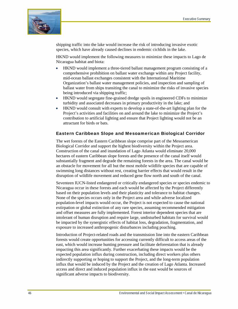
Executive Summary
46 Environmental and Social Impact Assessment • Canal de Nicaragua
shipping traffic into the lake would increase the risk of introducing invasive exotic species, which have already caused declines in endemic cichlids in the lake.
HKND would implement the following measures to minimize these impacts to Lago de Nicaragua habitat and biota: • HKND would implement a three-tiered ballast management program consisting of a
comprehensive prohibition on ballast water exchange within any Project facility, mid-ocean ballast exchanges consistent with the International Maritime Organization’s ballast water management policies, and inspection and sampling of ballast water from ships transiting the canal to minimize the risks of invasive species being introduced via shipping traffic;
• HKND would segregate fine-grained dredge spoils in engineered CDFs to minimize turbidity and associated decreases in primary productivity in the lake; and
• HKND would consult with experts to develop a state-of-the-art lighting plan for the Project’s activities and facilities on and around the lake to minimize the Project’s contribution to artificial lighting and ensure that Project lighting would not be an attractant for birds or bats.
Eastern Caribbean Slope and Mesoamerican Biological Corridor
The wet forests of the Eastern Caribbean slope comprise part of the Mesoamerican Biological Corridor and support the highest biodiversity within the Project area. Construction of the canal and inundation of Lago Atlanta would eliminate 20,000 hectares of eastern Caribbean slope forests and the presence of the canal itself would substantially fragment and degrade the remaining forests in the area. The canal would be an obstacle for movement for all but the most mobile wildlife species that are capable of swimming long distances without rest, creating barrier effects that would result in the disruption of wildlife movement and reduced gene flow north and south of the canal.
Seventeen IUCN-listed endangered or critically endangered species or species endemic to Nicaragua occur in these forests and each would be affected by the Project differently based on their population levels and their plasticity and tolerance to habitat changes. None of the species occurs only in the Project area and while adverse localized population-level impacts would occur, the Project is not expected to cause the national extirpation or global extinction of any rare species, assuming recommended mitigation and offset measures are fully implemented. Forest interior dependent species that are intolerant of human disruption and require large, undisturbed habitats for survival would be impacted by the synergistic effects of habitat loss, degradation, fragmentation, and exposure to increased anthropogenic disturbances including poaching.
Introduction of Project-related roads and the transmission line into the eastern Caribbean forests would create opportunities for accessing currently difficult to access areas of the east, which would increase hunting pressure and facilitate deforestation that is already impacting this area significantly. Further exacerbating these impacts would be the expected population influx during construction, including direct workers plus others indirectly supporting or hoping to support the Project, and the long-term population influx that would be induced by the Project and the creation of Lago Atlanta. Increased access and direct and induced population influx in the east would be sources of significant adverse impacts to biodiversity.

Executive Summary
Environmental and Social Impact Assessement • Canal de Nicaragua 47
The Project-related impacts on the eastern Caribbean forests and the Mesoamerican Biological Corridor must be considered in the context of the deforestation that is rapidly encroaching into the eastern portion of the Project area. Southeastern Nicaragua is undergoing rapid loss of forest cover resulting from the encroachment of agricultural and livestock grazing land uses.
There has been a 40 percent reduction in forest cover in the last 28 years in southeastern Nicaragua, including the eastern Caribbean slope portion of the Project area. Further, this rate of forest cover loss is increasing, with more forest lost in the 2 years between 2009 and 2011 than in the prior 26 years. It is clear that the remaining intact natural areas in southeast Nicaragua, within the Project area and outside it within and outside the protected areas, are highly vulnerable. Encroachment into these remote areas is already happening without the Project. The full and successful implementation of the mitigation and offsetting measures defined below could decelerate or even reverse these regional trends. Conversely, the Project would be expected to significantly accelerate these regional trends without the successful implementation of the recommended mitigation and offset measures.
HKND designed the Project to minimize the impacts of the canal on these forests by crossing the coastal forest at its narrowest point and by using hydraulic dredging in the easternmost portions of the Project area to limit disturbance to the canal footprint. However, the nature of the Project makes complete avoidance of impacts to these forests impossible. To mitigate and offset for these unavoidable impacts, and to strive towards the Project’s goal of achieving net positive impact on biodiversity, HKND proposes the following measures to mitigate and offset the unavoidable impacts to the eastern Caribbean forests and the Mesoamerican Biological Corridor: • Reforest roughly 20,000 hectares of degraded portions of the Punta Gorda and Cerro
Silva Nature Reserves in accordance with Nicaragua Decree 79-2006; • Coordinate with the Government of Nicaragua to fund, establish, restore, and actively
enforce a new Designated Preservation Area, which would include the Indio Maiz Biological Reserve, the Punta Gorda Nature Preserve, and portions of the Cerro Silva Nature Preserve to preserve the Mesoamerican Biological Corridor and other exceptional biodiversity areas remaining in southeastern Nicaragua (see Figure 20). Within this Preservation Area, ERM recommends that a prohibition on influx and in-migration would be enforced through access control and voluntary resettlement, degraded areas restored, protected areas managed, and a robust anti-poaching and logging enforcement program implemented, both for the construction workforce and others;
Jaguar (Panthera onca) photographed in the Project area
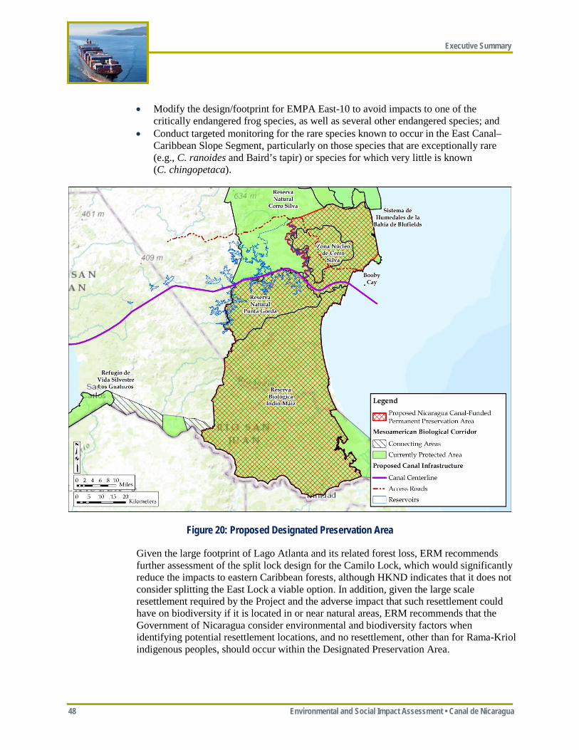
Executive Summary
48 Environmental and Social Impact Assessment • Canal de Nicaragua
• Modify the design/footprint for EMPA East-10 to avoid impacts to one of the critically endangered frog species, as well as several other endangered species; and
• Conduct targeted monitoring for the rare species known to occur in the East Canal–Caribbean Slope Segment, particularly on those species that are exceptionally rare (e.g., C. ranoides and Baird’s tapir) or species for which very little is known (C. chingopetaca).
Figure 20: Proposed Designated Preservation Area
Given the large footprint of Lago Atlanta and its related forest loss, ERM recommends further assessment of the split lock design for the Camilo Lock, which would significantly reduce the impacts to eastern Caribbean forests, although HKND indicates that it does not consider splitting the East Lock a viable option. In addition, given the large scale resettlement required by the Project and the adverse impact that such resettlement could have on biodiversity if it is located in or near natural areas, ERM recommends that the Government of Nicaragua consider environmental and biodiversity factors when identifying potential resettlement locations, and no resettlement, other than for Rama-Kriol indigenous peoples, should occur within the Designated Preservation Area.
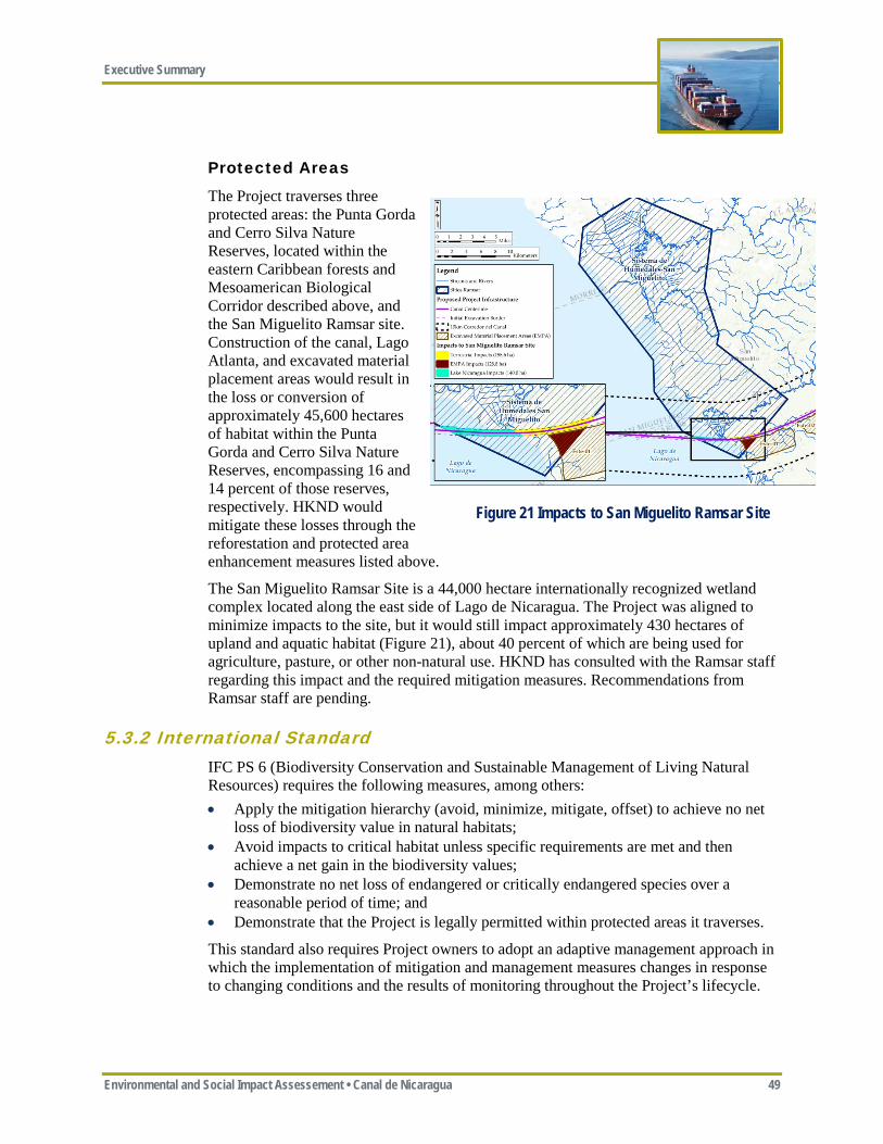
Executive Summary
Environmental and Social Impact Assessement • Canal de Nicaragua 49
Protected Areas
The Project traverses three protected areas: the Punta Gorda and Cerro Silva Nature Reserves, located within the eastern Caribbean forests and Mesoamerican Biological Corridor described above, and the San Miguelito Ramsar site. Construction of the canal, Lago Atlanta, and excavated material placement areas would result in the loss or conversion of approximately 45,600 hectares of habitat within the Punta Gorda and Cerro Silva Nature Reserves, encompassing 16 and 14 percent of those reserves, respectively. HKND would mitigate these losses through the reforestation and protected area enhancement measures listed above.
The San Miguelito Ramsar Site is a 44,000 hectare internationally recognized wetland complex located along the east side of Lago de Nicaragua. The Project was aligned to minimize impacts to the site, but it would still impact approximately 430 hectares of upland and aquatic habitat (Figure 21), about 40 percent of which are being used for agriculture, pasture, or other non-natural use. HKND has consulted with the Ramsar staff regarding this impact and the required mitigation measures. Recommendations from Ramsar staff are pending.
5.3.2 International Standard IFC PS 6 (Biodiversity Conservation and Sustainable Management of Living Natural Resources) requires the following measures, among others: • Apply the mitigation hierarchy (avoid, minimize, mitigate, offset) to achieve no net
loss of biodiversity value in natural habitats; • Avoid impacts to critical habitat unless specific requirements are met and then
achieve a net gain in the biodiversity values; • Demonstrate no net loss of endangered or critically endangered species over a
reasonable period of time; and • Demonstrate that the Project is legally permitted within protected areas it traverses.
This standard also requires Project owners to adopt an adaptive management approach in which the implementation of mitigation and management measures changes in response to changing conditions and the results of monitoring throughout the Project’s lifecycle.
Figure 21 Impacts to San Miguelito Ramsar Site
Executive Summary
50 Environmental and Social Impact Assessment • Canal de Nicaragua
5.3.3 ERM Conclusions and Recommendations The Project would cause significant adverse effects on biodiversity, some of which would not be directly mitigatable (e.g., the conversion of the Río Punta Gorda from a free flowing natural river system to a system of locks, canals, and impoundments; loss of primary forest, creating another barrier along the Mesoamerican Biological Corridor). However, with full and successful implementation of the mitigation and offsetting measures defined herein and considering the status quo of rampant deforestation in the Project region, the Project also has the opportunity to create lasting benefits for biodiversity. Although much of the canal alignment crosses internationally recognized protected areas, these protections are often unenforced and many of these areas have been significantly impacted by agricultural encroachment over the past decade. The remaining areas that are still pristine (e.g., Indio Maiz Biological Reserve and the narrow remaining portion of the Mesoamerican Biological Corridor between the Río Punta Gorda and the Bluefields Ramsar site) are seriously threatened. After endorsement and commitment by the Government of Nicaragua, the measures proposed by HKND to preserve the Indio Maiz Biological Reserve, restore the Punta Gorda Natural Area, and protect the integrity of the Mesoamerican Biological Corridor, along with other offset measures aimed at habitat protection and rare species conservation outside the Project area, would help move the Project toward the goal of Net Positive Impact. Successful implementation of these measures is critical or the Project would clearly result in overall significant adverse impacts to biodiversity.
ERM recommends the following: • HKND needs the Government of Nicaragua to agree to share in responsibility for
implementing some of the recommended mitigation measures that are beyond HKND’s legal authority to implement, such as enforcement of the Designated Preservation Area, voluntary resettlement from protected areas south of the canal, providing protected area status and related enforcement to sea turtle nesting beaches, and assisting in the managing of influx;
• The Government of Nicaragua should include the mitigation measures identified in this ESIA (see Appendices ES-B and ES-C) as a condition of any approval or permit, as the significance of the predicted impacts described in this ESIA are dependent on the proper implementation of these proposed mitigation measures. If these mitigation measures are not fully implemented, biodiversity impacts would be significantly worse than described;
• The Government of Nicaragua should require third party independent monitoring and at least semi-annual reporting during construction (e.g., an NGO or international consultant with experience in monitoring large construction projects) to ensure that the Project is being constructed and operated in accordance with approved plans, mitigation and offsetting measures are being fully and effectively implemented, and that no significant unforeseen impacts are occurring that require action. Where independent monitoring indicates that measures to mitigate and manage biodiversity impacts are ineffective or where unforeseen impacts arise, the Government of Nicaragua should retain the right to require HKND to adapt such mitigation or management measures.
Executive Summary
Environmental and Social Impact Assessement • Canal de Nicaragua 51
5.4 LAND EXPROPRIATION AND RESETTLEMENT
5.4.1 Issue The Government of Nicaragua has approved the expropriation of approximately 2,900 km2 of land for the canal, of which approximately 1,188 km2 (451 km2 of dry land) would be temporary and 1,721 km2 (908 km2 of dry land) would be permanent. The resulting displacement of human populations is one of the Project’s most significant impacts. This includes two types of displacement: physical displacement, which refers specifically to the relocation of or loss of shelter, and economic displacement, which refers to the loss of assets (or the loss of access to assets) and results in a loss of income or other means of livelihood.
In September and October 2014, HKND conducted a census of the population living in the Project Affected Areas. The census determined that approximately 30,000 people (or 7,210 families) would need to be physically or economically displaced. In December 2014, HKND reached an agreement with the Government of Nicaragua regarding expropriation boundaries.
Law 840 states that owners of land that is permanently expropriated for the canal would only be compensated at the lower of cadastral and fair market value of the property as of 14 June 2013. There are no provisions within Law 840 that require compensation for those without legal title or who otherwise occupy land on an informal or non-traditional basis. In addition, Law 840 expressly limits admissible grievances to those that relate to the amount of compensation, thereby prohibiting grievances that would seek to contest the decision, timing, or any other aspects of the expropriation.
At this time, a detailed proposal for land acquisition, resettlement, and compensation has not been disclosed to those affected. There has been limited engagement between the Government of Nicaragua, which has responsibility for land acquisition and resettlement, and households that would be displaced by the Project. Concerns about the legal authority granted under Law 840, the lack of publicly announced resettlement plans, and lack of meaningful consultation have combined to create uncertainty, unease, and distrust among potentially affected people. There have also been public protests in communities along the proposed canal route as well as in Managua, which are primarily focused on the issue of physical displacement.
5.4.2 HKND Proposed Management and Mitigation Measures HKND has recently committed publicly to respecting the rights of the Nicaraguan people by stating that Nicaraguan laws would be respected and property would be acquired according to market principles in a just, open, and transparent manner. However, to date, none of the critical components of, or information pertaining to, resettlement planning has been made public by the Government of Nicaragua or by HKND.
Executive Summary
52 Environmental and Social Impact Assessment • Canal de Nicaragua
5.4.3 International Standards IFC PS 5 (Land Acquisition and Involuntary Resettlement) includes specific requirements for private sector developers where government is responsible for land acquisition and resettlement.
Where land acquisition and resettlement are the responsibility of the government, the client will collaborate with the responsible government agency, to the extent permitted by the agency, to achieve outcomes that are consistent with PS 5. Where government capacity is limited, the developer should plan an active role during resettlement planning, implementation, and monitoring.
PS 5 requires compensation at “full replacement cost,” and provisions for compensating tenants, as well as those without property title or other recognizable rights, as long as their occupation or use commenced prior to the cut-off date. International standards require ongoing communication with displaced households before, during, and after resettlement.
5.4.4 ERM Conclusions and Recommendations The land expropriation and involuntary resettlement process to date has not met international standards. The Project risks losing its social license to operate and may jeopardize the viability of the Project by not following international standards. Law 840 is not consistent with international standards in respect to compensation and by limiting the rights of property owners to contest many aspects of the expropriation process.
ERM recommends that HKND, in cooperation with the Government of Nicaragua, complete and implement a Resettlement Action Plan (RAP) and a Livelihood Restoration and Compensation Framework (LRCF) that is consistent with international standards by: • Engaging and sharing information with affected persons in an open and transparent
manner, possibly with the intervention of a third party to restore trust in the process; • Compensating both property owners (for land and improvements) and tenants at fair
market values; • Ensuring that disclosure includes a well-publicized grievance procedure consistent
with the provisions of IFC PS 5; • Identifying alternative resettlement locations, with the provision of appropriate
infrastructure and outside the Designated Preservation Area, in consultation with displaced individuals; and
• Appointing an independent third party to monitor and evaluate all aspects of the resettlement program (i.e., expropriation of property, physical resettlement, disbursement of compensation, and the restoration and improvement in living standards and livelihoods of those displaced).
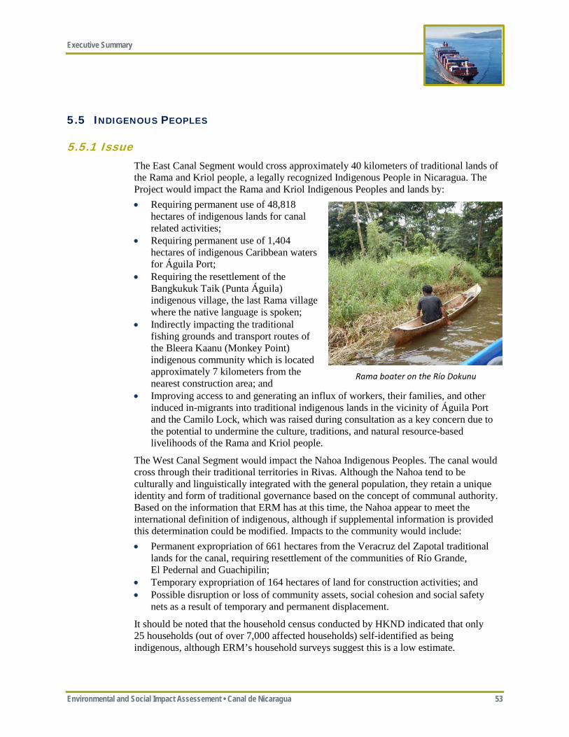
Executive Summary
Environmental and Social Impact Assessement • Canal de Nicaragua 53
5.5 INDIGENOUS PEOPLES
5.5.1 Issue The East Canal Segment would cross approximately 40 kilometers of traditional lands of the Rama and Kriol people, a legally recognized Indigenous People in Nicaragua. The Project would impact the Rama and Kriol Indigenous Peoples and lands by: • Requiring permanent use of 48,818
hectares of indigenous lands for canal related activities;
• Requiring permanent use of 1,404 hectares of indigenous Caribbean waters for Águila Port;
• Requiring the resettlement of the Bangkukuk Taik (Punta Águila) indigenous village, the last Rama village where the native language is spoken;
• Indirectly impacting the traditional fishing grounds and transport routes of the Bleera Kaanu (Monkey Point) indigenous community which is located approximately 7 kilometers from the nearest construction area; and
• Improving access to and generating an influx of workers, their families, and other induced in-migrants into traditional indigenous lands in the vicinity of Águila Port and the Camilo Lock, which was raised during consultation as a key concern due to the potential to undermine the culture, traditions, and natural resource-based livelihoods of the Rama and Kriol people.
The West Canal Segment would impact the Nahoa Indigenous Peoples. The canal would cross through their traditional territories in Rivas. Although the Nahoa tend to be culturally and linguistically integrated with the general population, they retain a unique identity and form of traditional governance based on the concept of communal authority. Based on the information that ERM has at this time, the Nahoa appear to meet the international definition of indigenous, although if supplemental information is provided this determination could be modified. Impacts to the community would include: • Permanent expropriation of 661 hectares from the Veracruz del Zapotal traditional
lands for the canal, requiring resettlement of the communities of Río Grande, El Pedernal and Guachipilin;
• Temporary expropriation of 164 hectares of land for construction activities; and • Possible disruption or loss of community assets, social cohesion and social safety
nets as a result of temporary and permanent displacement.
It should be noted that the household census conducted by HKND indicated that only 25 households (out of over 7,000 affected households) self-identified as being indigenous, although ERM’s household surveys suggest this is a low estimate.
Rama boater on the Río Dokunu
Executive Summary
54 Environmental and Social Impact Assessment • Canal de Nicaragua
5.5.2 HKND Proposed Management and Mitigation The Government of Nicaragua has assumed lead responsibility for consulting with Indigenous Peoples. The Government proposes to lease lands required for the canal rather than acquire them; therefore, there would be no technical loss of indigenous lands, although Indigenous Peoples would lose access to this land for operational and safety reasons. At this time, ERM is not aware of an official consent from the Indigenous Peoples affected by the Project.
5.5.3 International Standard IFC PS 7 (Indigenous Peoples) establishes international good practice relative to projects affecting Indigenous Peoples and lands. Requirements of this standard include: • Avoiding adverse impacts on Indigenous Peoples to the extent possible and
maintenance of critical cultural heritage such as language; • Establishing of an Informed Consultation and Participation process with Indigenous
People in the project area; • Establishing Free, Prior, and Informed Consent (FPIC) of Indigenous Peoples for the
use of their lands and other natural resources; • Where the government is responsible for the management of Indigenous Peoples
issues, collaboration of the project sponsor with the government to the extent feasible to achieve outcomes consistent with international standards; and
• Preparing an Indigenous Peoples Plan that describes how the Project would comply with international standards.
5.5.4 ERM Conclusions and Recommendations ERM concludes that the Project could not avoid impacting indigenous lands for this Project, as GTR-K lands extend along the entire length of Caribbean coastline through which a canal is considered feasible. The Project generally crosses the GTR-K lands at the narrowest point; but would directly impact one Rama-Kriol village, while also impacting Nahoa lands and villages. ERM recommends the following measures: • The Government of Nicaragua should initiate consultation with the Nahoa
community in a form similar to that currently being undertaken with the GTR-K; • All consultations with indigenous peoples should be in accordance with international
standards, and FPIC should be secured before any canal construction begins; • HKND should further explore options to avoid the relocation of the Bangkukuk Taik
village and minimize impacts on the Nahoa traditional lands; • If resettlement of the Bangkukuk Taik village is unavoidable, preference should be
given to resettling its Indigenous Peoples as a whole in order to preserve cultural identity, language, and social cohesion;
• If and when FPIC is obtained, HKND should finalize an Indigenous People Plan with the GTR-K and Nahoa that reflects any conditions of granting FPIC, and establishes an ongoing process of consultation throughout canal construction and operations; and
• HKND and the Government of Nicaragua should provide financial, legal, and technical support to help the GTR-K manage influx issues consistent with their desired objectives.
Executive Summary
Environmental and Social Impact Assessement • Canal de Nicaragua 55
5.6 PROJECT AFFECTED COMMUNITIES
5.6.1 Issue Project-Affected Communities (PACs) are those communities located within the Project Area of Influence (i.e., in general proximity to the canal that would likely be most affected directly or indirectly by canal construction and operation). PACs would experience various types and degrees of impacts depending on the canal segment along which they are located, their proximity to Project facilities (e.g., worker camps, ports), and whether they live north or south of the canal. One of the greatest impacts to PACs is population influx, which is addressed in Section 5.7. Additional impacts to PACs could include: • Exposure to nuisance level impacts associated with construction, including fugitive
dust, noise, and vibration which may result in health impacts; • Potential conflicts with construction workers, both foreign and domestic, due to
inequality in pay and different cultural norms; • Loss of access to surface water, rivers or tributaries; • Creation of Lago Atlanta and other reservoirs would affect how communities access
and use water for health and sanitation, watering livestock, and transportation; • Temporary decrease in access to current levels of potable water and/or electricity,
where available, due to the construction of the canal and its associated facilities; • Overburdening of or loss of access to schools, and health services; • Loss of livelihoods due to increased pressure on natural resources such as agricultural
land, deforestation, firewood, and non-timber resources; • Changes in social cohesion and connectivity for families and communities which
would be separated by the canal; • Increases in prostitution and human trafficking; • Increases in sanitation-related diseases due to decreases in water quality and quantity;
and • Increases in food insecurity/malnutrition associated with increased costs of food and
decreases in the availability of food resources.
5.6.2 HKND Proposed Management and Mitigation Measures • HKND has committed to the following measures to minimize impacts to Affected
Communities: HKND would ensure communities would continue to have North-South access across the canal by building a bridge at the Pan-American Highway (which would accommodate bicyclists and pedestrians), establishing a ferry at San Carlos-Acoyapa roadway, and allow canal crossings at Lago Atlanta and the Camillo Lock;
• HKND would construct public east-west roads on both sides of much of the canal; • HKND would provide alternative sources of water supply to any household or
community if their existing supplies are affected by Project construction or operation; • HKND would repair or replace any public infrastructure damaged during
construction (e.g., electricity), and would compensate for all public services (e.g., health centers, schools) that would be lost as a result of canal construction;
Executive Summary
56 Environmental and Social Impact Assessment • Canal de Nicaragua
• HKND would ensure the grievance mechanism meets international good practice standards;
• HKND would ensure that dredging and ship transit schedules are made available to fishermen and boat operators in the Lago de Nicaragua or the marine entrances;
• Support development of programs to improve farming and ranching skills for economically displaced farmers;
• HKND would establish partnerships with universities and institutes (e.g. Instituto Nacional Tecnológico—INATEC) to develop programs aimed at training high-skilled potential employees for the Project; and
• HKND would continue to engage in robust stakeholder consultation procedures with Project Affected Communities.
5.6.3 International Standard IFC PS 1 (Environmental and Social Risks) requires identification of and management of social risks through avoidance or mitigation and requires effective community engagement and consultation with PACs. IFC PS 4 (Community Health, Safety, and Security) requires identification and mitigation/avoidance of potential exposure to water and vector-borne communicable diseases that could result from Project activities.
5.6.4 ERM Conclusions and Recommendations ERM concludes that nuisance issues such as noise, dust, and vibration can be effectively minimized by applying good international practice. However, social and health impacts that could arise as a result of changes in access and population influx would be more challenging to minimize and avoid. As described above, HKND has adopted several management measures that reflect international good practice in minimizing impacts to PACs. In addition, ERM also recommends the following: • HKND should develop a Livelihood Restoration and Compensation Framework
(LRCF) that meets international standards and provides existing farmers, fishermen, ranchers and tourism operators with compensation to maintain and/or restore their livelihoods during both construction and operation phases;
• HKND should establish a Community Relations Team to work with PACs to avoid, minimize, and correct as necessary adverse Project impacts on local communities;
• HKND and its contractors should adopt a zero tolerance policy (i.e., termination) relative to any significant employee infractions of its Code of Conduct;
• HKND should implement a comprehensive worker health program that includes health education and provision of communicable disease screening and treatment;
• HKND should implement a comprehensive traffic management plan that includes speed control measures, mandatory driver training, and use of alternative routes that avoid residential and high traffic areas to minimize the risk of accidents; and
• HKND should assist PACs affected by the loss of access to health services (e.g., clinics and hospitals) and schools by providing alternative or additional resources.
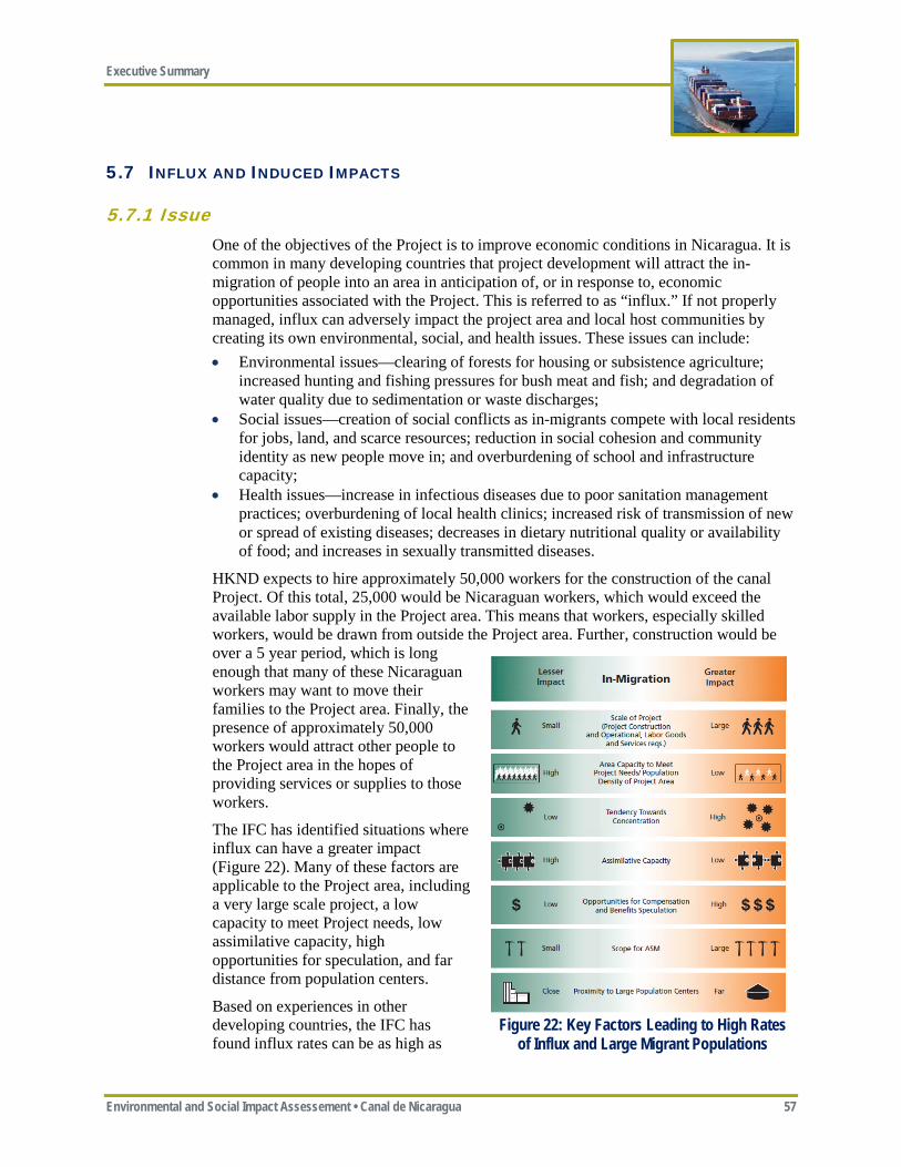
Executive Summary
Environmental and Social Impact Assessement • Canal de Nicaragua 57
5.7 INFLUX AND INDUCED IMPACTS
5.7.1 Issue One of the objectives of the Project is to improve economic conditions in Nicaragua. It is common in many developing countries that project development will attract the in-migration of people into an area in anticipation of, or in response to, economic opportunities associated with the Project. This is referred to as “influx.” If not properly managed, influx can adversely impact the project area and local host communities by creating its own environmental, social, and health issues. These issues can include: • Environmental issues—clearing of forests for housing or subsistence agriculture;
increased hunting and fishing pressures for bush meat and fish; and degradation of water quality due to sedimentation or waste discharges;
• Social issues—creation of social conflicts as in-migrants compete with local residents for jobs, land, and scarce resources; reduction in social cohesion and community identity as new people move in; and overburdening of school and infrastructure capacity;
• Health issues—increase in infectious diseases due to poor sanitation management practices; overburdening of local health clinics; increased risk of transmission of new or spread of existing diseases; decreases in dietary nutritional quality or availability of food; and increases in sexually transmitted diseases.
HKND expects to hire approximately 50,000 workers for the construction of the canal Project. Of this total, 25,000 would be Nicaraguan workers, which would exceed the available labor supply in the Project area. This means that workers, especially skilled workers, would be drawn from outside the Project area. Further, construction would be over a 5 year period, which is long enough that many of these Nicaraguan workers may want to move their families to the Project area. Finally, the presence of approximately 50,000 workers would attract other people to the Project area in the hopes of providing services or supplies to those workers.
The IFC has identified situations where influx can have a greater impact (Figure 22). Many of these factors are applicable to the Project area, including a very large scale project, a low capacity to meet Project needs, low assimilative capacity, high opportunities for speculation, and far distance from population centers.
Based on experiences in other developing countries, the IFC has found influx rates can be as high as
Figure 22: Key Factors Leading to High Rates of Influx and Large Migrant Populations
Executive Summary
58 Environmental and Social Impact Assessment • Canal de Nicaragua
10 to 15 percent of the host population, compounded annually, which could equate to an influx of over 150,000 people to the Project area over the five year construction period, although ERM believes this is a high end estimate. The in-migration of this number of people could result in significant environmental, social, and health impacts, especially considering the environmentally and culturally sensitive areas nearby, including undermining key biodiversity mitigation/offset measures and/or encroaching into GTR-K indigenous lands, thereby further threatening indigenous traditions and culture.
5.7.2 HKND Proposed Management and Mitigation Measures HKND has committed to the following measures to manage the potential impacts from influx: • HKND would limit hiring of workers within Nicaragua to designated hiring centers
in a few regional centers (e.g., Managua, Rivas, Nueva Guinea, Bluefields) in order to limit the potential for in-migration to the construction areas. With minor exceptions, no hiring would occur at the construction site;
• All foreign workers would be expected to reside in the worker camps, although some management staff working from the Construction Management Office may be housed separately in Rivas and towns adjacent to the East Canal. Otherwise, only workers from nearby communities would be allowed to live outside the camps. Only foreign managers would be allowed to bring their families to Nicaragua;
• HKND would require worker camp operators to strictly enforce Camp Management Procedures that would prohibit informal trade, squatter camps, hunting and fishing, purchasing of any wildlife products (e.g., bushmeat, turtle eggs), and prostitution within the worker camps and the temporary expropriation area;
• The worker camps would be operated as “closed camps”—in that workers (other than local Nicaraguans who live nearby) would not be allowed to leave the camps unless part of an organized trip to buy personal items, for entertainment, or to sightsee; and
• HKND would monitor population growth in local communities and coordinate with the Government of Nicaragua to assist PACs in managing influx by providing training and funding to increase the capacity of local infrastructure and services commensurate with the level of influx, and enforcing a no in-migration policy to the Designated Preservation Area (Figure 20).
5.7.3 International Standard The IFC has issued A Handbook for Addressing Project-Induced In-Migration (IFC 2009). This Handbook identifies strategies for managing impacts associated with influx.
5.7.4 ERM Conclusions and Recommendations HKND has agreed to several measures for managing influx as summarized above, but needs to strictly enforce these measures, monitor for influx, and apply adaptive management principles if monitoring shows that influx is creating significant environmental and social impacts. The Government of Nicaragua, possibly with assistance from HKND, would likely need to use its legal and police powers to assist in controlling influx.
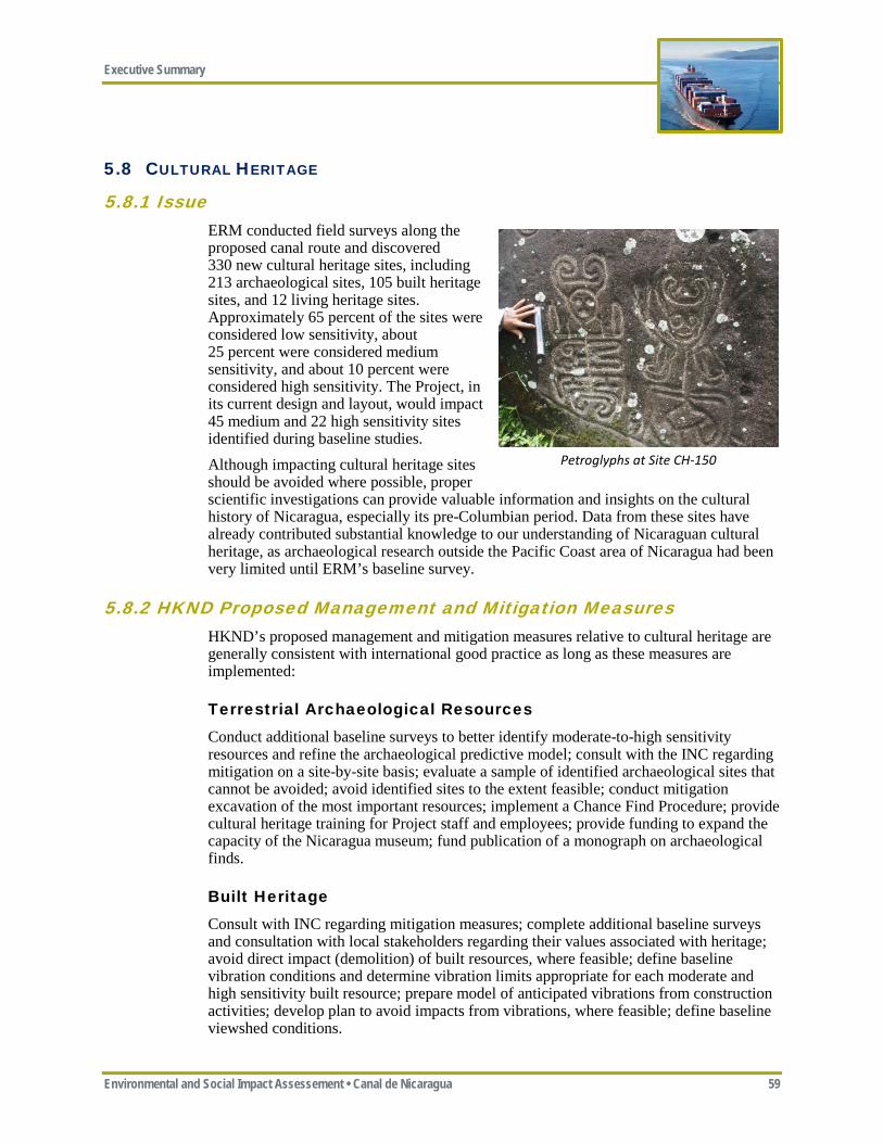
Executive Summary
Environmental and Social Impact Assessement • Canal de Nicaragua 59
5.8 CULTURAL HERITAGE
5.8.1 Issue ERM conducted field surveys along the proposed canal route and discovered 330 new cultural heritage sites, including 213 archaeological sites, 105 built heritage sites, and 12 living heritage sites. Approximately 65 percent of the sites were considered low sensitivity, about 25 percent were considered medium sensitivity, and about 10 percent were considered high sensitivity. The Project, in its current design and layout, would impact 45 medium and 22 high sensitivity sites identified during baseline studies. Although impacting cultural heritage sites should be avoided where possible, proper scientific investigations can provide valuable information and insights on the cultural history of Nicaragua, especially its pre-Columbian period. Data from these sites have already contributed substantial knowledge to our understanding of Nicaraguan cultural heritage, as archaeological research outside the Pacific Coast area of Nicaragua had been very limited until ERM’s baseline survey.
5.8.2 HKND Proposed Management and Mitigation Measures HKND’s proposed management and mitigation measures relative to cultural heritage are generally consistent with international good practice as long as these measures are implemented:
Terrestrial Archaeological Resources Conduct additional baseline surveys to better identify moderate-to-high sensitivity resources and refine the archaeological predictive model; consult with the INC regarding mitigation on a site-by-site basis; evaluate a sample of identified archaeological sites that cannot be avoided; avoid identified sites to the extent feasible; conduct mitigation excavation of the most important resources; implement a Chance Find Procedure; provide cultural heritage training for Project staff and employees; provide funding to expand the capacity of the Nicaragua museum; fund publication of a monograph on archaeological finds.
Built Heritage Consult with INC regarding mitigation measures; complete additional baseline surveys and consultation with local stakeholders regarding their values associated with heritage; avoid direct impact (demolition) of built resources, where feasible; define baseline vibration conditions and determine vibration limits appropriate for each moderate and high sensitivity built resource; prepare model of anticipated vibrations from construction activities; develop plan to avoid impacts from vibrations, where feasible; define baseline viewshed conditions.
Petroglyphs at Site CH-150
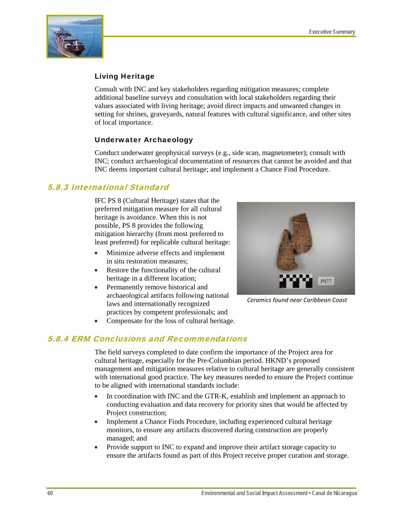
Executive Summary
60 Environmental and Social Impact Assessment • Canal de Nicaragua
Living Heritage
Consult with INC and key stakeholders regarding mitigation measures; complete additional baseline surveys and consultation with local stakeholders regarding their values associated with living heritage; avoid direct impacts and unwanted changes in setting for shrines, graveyards, natural features with cultural significance, and other sites of local importance.
Underwater Archaeology
Conduct underwater geophysical surveys (e.g., side scan, magnetometer); consult with INC; conduct archaeological documentation of resources that cannot be avoided and that INC deems important cultural heritage; and implement a Chance Find Procedure.
5.8.3 International Standard IFC PS 8 (Cultural Heritage) states that the preferred mitigation measure for all cultural heritage is avoidance. When this is not possible, PS 8 provides the following mitigation hierarchy (from most preferred to least preferred) for replicable cultural heritage: • Minimize adverse effects and implement
in situ restoration measures; • Restore the functionality of the cultural
heritage in a different location; • Permanently remove historical and
archaeological artifacts following national laws and internationally recognized practices by competent professionals; and
• Compensate for the loss of cultural heritage.
5.8.4 ERM Conclusions and Recommendations The field surveys completed to date confirm the importance of the Project area for cultural heritage, especially for the Pre-Columbian period. HKND’s proposed management and mitigation measures relative to cultural heritage are generally consistent with international good practice. The key measures needed to ensure the Project continue to be aligned with international standards include: • In coordination with INC and the GTR-K, establish and implement an approach to
conducting evaluation and data recovery for priority sites that would be affected by Project construction;
• Implement a Chance Finds Procedure, including experienced cultural heritage monitors, to ensure any artifacts discovered during construction are properly managed; and
• Provide support to INC to expand and improve their artifact storage capacity to ensure the artifacts found as part of this Project receive proper curation and storage.
Ceramics found near Caribbean Coast
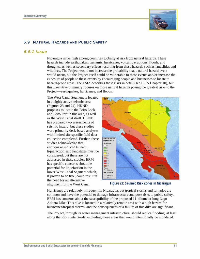
Executive Summary
Environmental and Social Impact Assessement • Canal de Nicaragua 61
5.9 NATURAL HAZARDS AND PUBLIC SAFETY
5.9.1 Issue Nicaragua ranks high among countries globally at risk from natural hazards. These hazards include earthquakes, tsunamis, hurricanes, volcanic eruptions, floods, and droughts, as well as secondary effects resulting from these hazards such as landslides and wildfires. The Project would not increase the probability that a natural hazard event would occur, but the Project itself could be vulnerable to these events and/or increase the exposure of people to these events by encouraging people and businesses to locate to hazard-prone areas. The ESIA describes these risks in detail (see ESIA Chapter 10), but this Executive Summary focuses on those natural hazards posing the greatest risks to the Project—earthquakes, hurricanes, and floods.
The West Canal Segment is located in a highly active seismic area (Figures 23 and 24). HKND proposes to locate the Brito Lock and Brito Port in this area, as well as the West Canal itself. HKND has prepared two assessments of seismic hazard, but these studies were primarily desk-based analyses with limited site specific field data collection completed. Further, these studies acknowledge that earthquake induced tsunami, liquefaction, and landslides must be considered, but these are not addressed in these studies. ERM has specific concerns about the potential for liquefaction in the lower West Canal Segment which, if proven to be true, could result in the need for an alternative alignment for the West Canal.
Hurricanes are relatively infrequent in Nicaragua, but tropical storms and tornados are common and have the potential to damage infrastructure and pose risks to public safety. ERM has concerns about the susceptibility of the proposed 11-kilometer long Lago Atlanta Dike. This dike is located in a relatively remote area with a high hazard for hurricanes/tropical storms, and the consequences of a failure of this dike are significant.
The Project, through its water management infrastructure, should reduce flooding, at least along the Río Punta Gorda, excluding those areas that would intentionally be inundated.
Figure 23: Seismic Risk Zones in Nicaragua
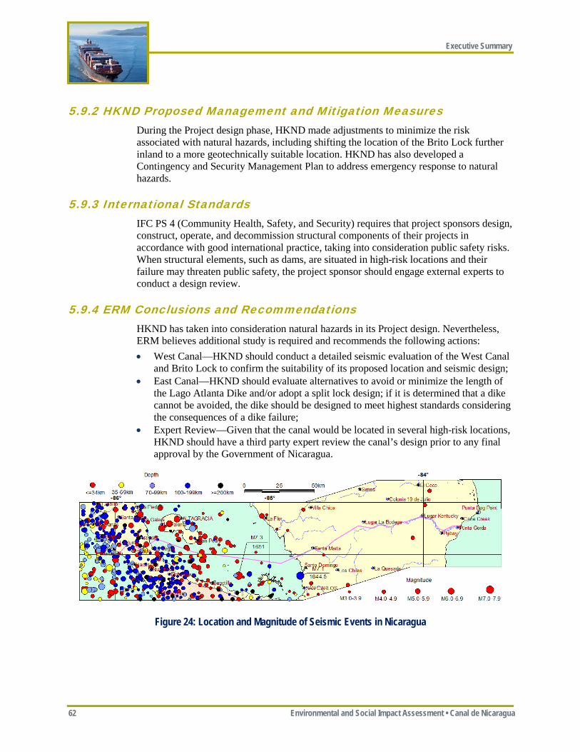
Executive Summary
62 Environmental and Social Impact Assessment • Canal de Nicaragua
5.9.2 HKND Proposed Management and Mitigation Measures During the Project design phase, HKND made adjustments to minimize the risk associated with natural hazards, including shifting the location of the Brito Lock further inland to a more geotechnically suitable location. HKND has also developed a Contingency and Security Management Plan to address emergency response to natural hazards.
5.9.3 International Standards IFC PS 4 (Community Health, Safety, and Security) requires that project sponsors design, construct, operate, and decommission structural components of their projects in accordance with good international practice, taking into consideration public safety risks. When structural elements, such as dams, are situated in high-risk locations and their failure may threaten public safety, the project sponsor should engage external experts to conduct a design review.
5.9.4 ERM Conclusions and Recommendations HKND has taken into consideration natural hazards in its Project design. Nevertheless, ERM believes additional study is required and recommends the following actions: • West Canal—HKND should conduct a detailed seismic evaluation of the West Canal
and Brito Lock to confirm the suitability of its proposed location and seismic design; • East Canal—HKND should evaluate alternatives to avoid or minimize the length of
the Lago Atlanta Dike and/or adopt a split lock design; if it is determined that a dike cannot be avoided, the dike should be designed to meet highest standards considering the consequences of a dike failure;
• Expert Review—Given that the canal would be located in several high-risk locations, HKND should have a third party expert review the canal’s design prior to any final approval by the Government of Nicaragua.
Figure 24: Location and Magnitude of Seismic Events in Nicaragua
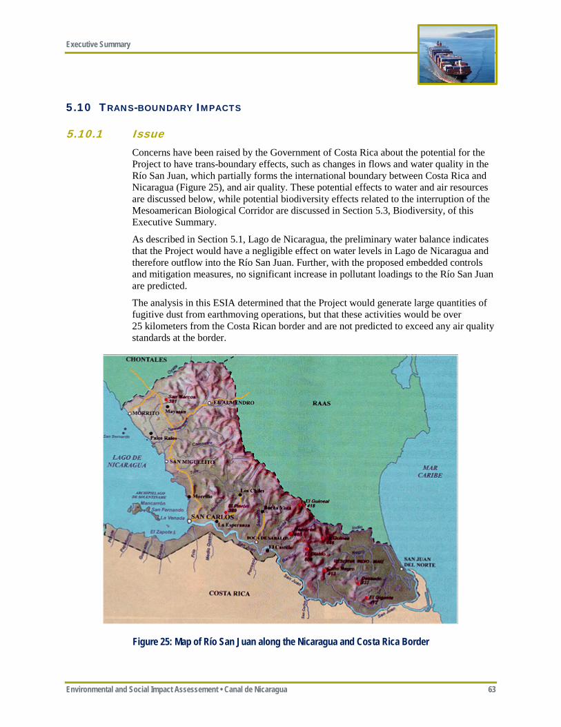
Executive Summary
Environmental and Social Impact Assessement • Canal de Nicaragua 63
5.10 TRANS-BOUNDARY IMPACTS
5.10.1 Issue Concerns have been raised by the Government of Costa Rica about the potential for the Project to have trans-boundary effects, such as changes in flows and water quality in the Río San Juan, which partially forms the international boundary between Costa Rica and Nicaragua (Figure 25), and air quality. These potential effects to water and air resources are discussed below, while potential biodiversity effects related to the interruption of the Mesoamerican Biological Corridor are discussed in Section 5.3, Biodiversity, of this Executive Summary.
As described in Section 5.1, Lago de Nicaragua, the preliminary water balance indicates that the Project would have a negligible effect on water levels in Lago de Nicaragua and therefore outflow into the Río San Juan. Further, with the proposed embedded controls and mitigation measures, no significant increase in pollutant loadings to the Río San Juan are predicted.
The analysis in this ESIA determined that the Project would generate large quantities of fugitive dust from earthmoving operations, but that these activities would be over 25 kilometers from the Costa Rican border and are not predicted to exceed any air quality standards at the border.
Figure 25: Map of Río San Juan along the Nicaragua and Costa Rica Border

Executive Summary
64 Environmental and Social Impact Assessment • Canal de Nicaragua
5.10.2 Government of Nicaragua and HKND Proposed Measures The Government of Nicaragua and HKND have adopted three important measures to avoid and minimize the potential for trans-boundary impacts from the Project on Costa Rica: • Although historically the preferred route for the canal was along the Río San Juan,
HKND eliminated a Río San Juan route as part of its screening process, at least partially at the direction of the Government of Nicaragua;
• HKND designed the Project to essentially avoid any net use of Lago de Nicaragua water for canal operations, which in turn should result in negligible changes in Río San Juan flows and the availability of water downstream for navigation and other uses; and
• HKND has committed to international good practice relative to the required dredging of Lago de Nicaragua.
5.10.3 International Standards The IFC PSs require that: • Countries potentially affected by the trans-boundary effects of a project should be
notified and consulted; • Project sponsors should avoid, or minimize and control the release of pollutants to
air, water, and land with the potential for trans-boundary effects.
5.10.4 ERM Conclusions and Recommendations Based on available hydrology and lake sediment data, it appears that the Project would have negligible effect on flows and water quality in the Río San Juan. ERM recommends that: • HKND should complete a comprehensive Project water balance and sediment
stratigraphy study to confirm preliminary data that suggest the Project would have negligible impact on flows and water quality in the Río San Juan; and
• HKND should monitor and publicly report water levels in Lago de Nicaragua and Río San Juan flows and water quality to confirm that the Project is having negligible effects.
Executive Summary
Environmental and Social Impact Assessement • Canal de Nicaragua 65
6 ESIA CONCLUSIONS AND RECOMMENDATIONS
6.1 CONCLUSIONS This section describes the key findings of this ESIA relative to the ESIA process, route selection, the adequacy of Project design, the Project’s major benefits and impacts, and conformance with international standards.
6.1.1 ESIA Process and Stakeholder Engagement The ESIA Process, and specifically the extent of stakeholder engagement and the amount of publicly-available information about the Project, has been criticized by several environmental organizations, civil society, and foreign governments as being inadequate and lacking transparency. Consultation and information sharing with people potentially subject to involuntary resettlement has been especially inadequate. Many protests have occurred in Nicaragua over the past six months, including at least one violent clash between protesters and Nicaraguan security forces.
Opinion polls show that the Project has the support of most Nicaraguans (approximately 83 percent either fully or partially support the Project according to the most recent poll by M&R Consulting from late March 2015), although this support is significantly reduced in the Project area where only about 42 percent support the Project (survey reports from December 2014). At this point, the Project has not implemented an effective Informed Consultation and Participation Process and the Project does not appear to have “broad community support” by Project Affected Communities, as required by international standards. Additional efforts are needed to help stakeholders better understand the Project and the extent to which they and other resources of interest would be affected by the Project. This ESIA attempts to do that, and, given the criticisms about the lack of transparency, it is critical that sufficient time be allowed for the public to review this ESIA and understand the Project effects. In addition to this ESIA, additional information and direct consultation is needed, especially with those people who would be physically and/or economically displaced by the Project.
6.1.2 Route Selection All routes for a Canal de Nicaragua through the Study Area would have significant environmental and social impacts, as essentially all of the economically feasible routes would need to traverse internationally recognized protected areas, legally-recognized indigenous lands, and Lago de Nicaragua, all of which under normal situations would be considered no-go areas.
ERM considers the proposed route (i.e., Route 4) as the only route with the potential to adequately mitigate/offset its impacts and meet international standards. This determination was contingent on HKND providing funding and coordinating with the Government of Nicaragua to assure the restoration and permanent enforcement of the proposed Designated Preservation Area (Figure 20), in addition to other environmental and social mitigation and offset measures recommended in this ESIA. Absent these commitments, even Route 4 would not be able to achieve no net loss or meet international good practice.
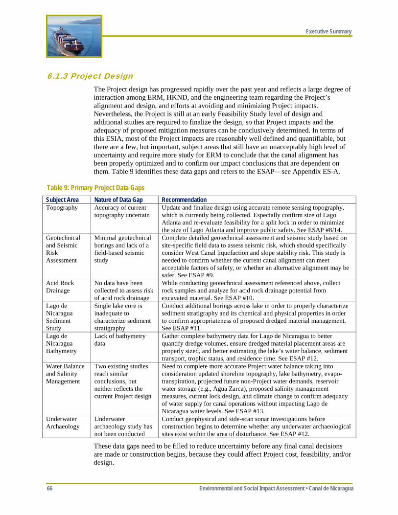
Executive Summary
66 Environmental and Social Impact Assessment • Canal de Nicaragua
6.1.3 Project Design The Project design has progressed rapidly over the past year and reflects a large degree of interaction among ERM, HKND, and the engineering team regarding the Project’s alignment and design, and efforts at avoiding and minimizing Project impacts. Nevertheless, the Project is still at an early Feasibility Study level of design and additional studies are required to finalize the design, so that Project impacts and the adequacy of proposed mitigation measures can be conclusively determined. In terms of this ESIA, most of the Project impacts are reasonably well defined and quantifiable, but there are a few, but important, subject areas that still have an unacceptably high level of uncertainty and require more study for ERM to conclude that the canal alignment has been properly optimized and to confirm our impact conclusions that are dependent on them. Table 9 identifies these data gaps and refers to the ESAP—see Appendix ES-A.
Table 9: Primary Project Data Gaps Subject Area Nature of Data Gap Recommendation Topography Accuracy of current
topography uncertain Update and finalize design using accurate remote sensing topography, which is currently being collected. Especially confirm size of Lago Atlanta and re-evaluate feasibility for a split lock in order to minimize the size of Lago Atlanta and improve public safety. See ESAP #8/14.
Geotechnical and Seismic Risk Assessment
Minimal geotechnical borings and lack of a field-based seismic study
Complete detailed geotechnical assessment and seismic study based on site-specific field data to assess seismic risk, which should specifically consider West Canal liquefaction and slope stability risk. This study is needed to confirm whether the current canal alignment can meet acceptable factors of safety, or whether an alternative alignment may be safer. See ESAP #9.
Acid Rock Drainage
No data have been collected to assess risk of acid rock drainage
While conducting geotechnical assessment referenced above, collect rock samples and analyze for acid rock drainage potential from excavated material. See ESAP #10.
Lago de Nicaragua Sediment Study
Single lake core is inadequate to characterize sediment stratigraphy
Conduct additional borings across lake in order to properly characterize sediment stratigraphy and its chemical and physical properties in order to confirm appropriateness of proposed dredged material management. See ESAP #11.
Lago de Nicaragua Bathymetry
Lack of bathymetry data
Gather complete bathymetry data for Lago de Nicaragua to better quantify dredge volumes, ensure dredged material placement areas are properly sized, and better estimating the lake’s water balance, sediment transport, trophic status, and residence time. See ESAP #12.
Water Balance and Salinity Management
Two existing studies reach similar conclusions, but neither reflects the current Project design
Need to complete more accurate Project water balance taking into consideration updated shoreline topography, lake bathymetry, evapo-transpiration, projected future non-Project water demands, reservoir water storage (e.g., Agua Zarca), proposed salinity management measures, current lock design, and climate change to confirm adequacy of water supply for canal operations without impacting Lago de Nicaragua water levels. See ESAP #13.
Underwater Archaeology
Underwater archaeology study has not been conducted
Conduct geophysical and side-scan sonar investigations before construction begins to determine whether any underwater archaeological sites exist within the area of disturbance. See ESAP #12.
These data gaps need to be filled to reduce uncertainty before any final canal decisions are made or construction begins, because they could affect Project cost, feasibility, and/or design.

Executive Summary
Environmental and Social Impact Assessement • Canal de Nicaragua 67
6.1.4 Project Cost—Benefit Comparison This section qualitatively compares the Project’s costs (i.e., impacts) with its benefits. It does not attempt to quantitatively determine whether the costs or the benefits outweighs the other, but does summarize the Project’s major impacts and benefits. A discussion of possible future growth scenarios is also provided to help put the Project’s costs and benefits in context with other possible outcomes.
Project Costs (Impacts)
It is impossible to construct a project of this magnitude, especially in an area with the environmental, social, and cultural sensitivities of southern Nicaragua, without having significant impacts. HKND has adopted many measures to avoid and minimize the environmental and social impacts of the Project, but the Canal de Nicaragua would still result in significant impacts. The major unavoidable adverse impacts would include: • Loss of intact primary and secondary rainforest; • Fragmentation of the Mesoamerican Biological Corridor, functioning as a barrier to
animal movement and gene flow, and isolation of populations; • Conversion of the ecologically diverse Río Punta Gorda from a natural free flowing
river to a system of locks, canals, and impoundments; • Loss of some nesting, foraging, and migratory habitat for critically endangered and
endangered sea turtles; • Loss of individuals for several Critically Endangered and Endangered species; • Introduction of invasive species into the Río Punta Gorda river system; • Increased sediment loads into the Pacific Ocean, Caribbean Sea, and Lago de
Nicaragua during construction; • Physical division of Nicaragua into areas north and south of the canal, with
associated reductions in access and connectivity; • Physical and economic displacement of approximately 30,000 people; and • Displacement of the last Rama village that still speaks the native language.
In addition to these known impacts, the Project would also increase the risk of other impacts occurring, including: • Increased risk of influx and induced development in ecological and culturally
sensitive areas, such as the eastern Caribbean rainforest and adjacent coastal area; • Increased risk of spills in, and introduction of invasive species to, Lago de Nicaragua,
and the Pacific and Caribbean coastal areas; • Increased risk of localized deterioration of Lago de Nicaragua water quality as a
result of initial and on-going maintenance dredging and resuspension of sediments by ship traffic;
• Increased risk of marine mammal and turtle ship strikes because of increased shipping activity in known migratory, foraging, and nesting areas;
• Increased prevalence of human trafficking and associated sexually transmitted diseases as a result of influx; and
• Decrease in social cohesion, community identity, safety and security, and strain on infrastructure due to anticipated influx near both ports and near worker camps.
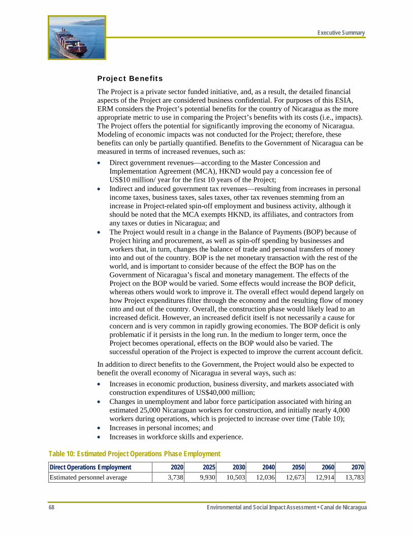
Executive Summary
68 Environmental and Social Impact Assessment • Canal de Nicaragua
Project Benefits
The Project is a private sector funded initiative, and, as a result, the detailed financial aspects of the Project are considered business confidential. For purposes of this ESIA, ERM considers the Project’s potential benefits for the country of Nicaragua as the more appropriate metric to use in comparing the Project’s benefits with its costs (i.e., impacts). The Project offers the potential for significantly improving the economy of Nicaragua. Modeling of economic impacts was not conducted for the Project; therefore, these benefits can only be partially quantified. Benefits to the Government of Nicaragua can be measured in terms of increased revenues, such as: • Direct government revenues—according to the Master Concession and
Implementation Agreement (MCA), HKND would pay a concession fee of US$10 million/ year for the first 10 years of the Project;
• Indirect and induced government tax revenues—resulting from increases in personal income taxes, business taxes, sales taxes, other tax revenues stemming from an increase in Project-related spin-off employment and business activity, although it should be noted that the MCA exempts HKND, its affiliates, and contractors from any taxes or duties in Nicaragua; and
• The Project would result in a change in the Balance of Payments (BOP) because of Project hiring and procurement, as well as spin-off spending by businesses and workers that, in turn, changes the balance of trade and personal transfers of money into and out of the country. BOP is the net monetary transaction with the rest of the world, and is important to consider because of the effect the BOP has on the Government of Nicaragua’s fiscal and monetary management. The effects of the Project on the BOP would be varied. Some effects would increase the BOP deficit, whereas others would work to improve it. The overall effect would depend largely on how Project expenditures filter through the economy and the resulting flow of money into and out of the country. Overall, the construction phase would likely lead to an increased deficit. However, an increased deficit itself is not necessarily a cause for concern and is very common in rapidly growing economies. The BOP deficit is only problematic if it persists in the long run. In the medium to longer term, once the Project becomes operational, effects on the BOP would also be varied. The successful operation of the Project is expected to improve the current account deficit.
In addition to direct benefits to the Government, the Project would also be expected to benefit the overall economy of Nicaragua in several ways, such as: • Increases in economic production, business diversity, and markets associated with
construction expenditures of US$40,000 million; • Changes in unemployment and labor force participation associated with hiring an
estimated 25,000 Nicaraguan workers for construction, and initially nearly 4,000 workers during operations, which is projected to increase over time (Table 10);
• Increases in personal incomes; and • Increases in workforce skills and experience.
Table 10: Estimated Project Operations Phase Employment Direct Operations Employment 2020 2025 2030 2040 2050 2060 2070 Estimated personnel average 3,738 9,930 10,503 12,036 12,673 12,914 13,783

Executive Summary
Environmental and Social Impact Assessement • Canal de Nicaragua 69
While real, many of the potential benefits to the economy are indirect and difficult to quantify since they are related to the success of international trade, port activity, and the economic benefits associated with infrastructure improvements provided by the Project (e.g., improved roads). The Project is expected to contribute to the expansion and development of service-oriented activities along the canal. Businesses to benefit from the Project would likely include storage, ship repair, break bulk (the unloading of a portion or all of a ship's cargo), trans-shipment, bunkering, distribution, and services to ship travelers.
The Project should have economic benefits, but also could have some environmental and social benefits if the proposed mitigation measures are properly implemented. For example, permanent protection and preservation of the proposed Designated Preservation Area, including the Indio Maiz Biological Reserve, Punta Gorda Nature Reserve, and the Mesoamerican Biological Corridor in the Project area would represent a real environmental and social benefit. HKND and the Government of Nicaragua have stated that those people who would require physical resettlement would receive improved housing and livelihood opportunities, although at this point a full Resettlement Action Plan has not yet been disclosed to determine if this goal would be met.
Future Growth Scenarios
While the Project is fraught with risks and uncertainties, alternative future scenarios without a canal are also subject to considerable uncertainty. This section compares the relative benefits and impacts of different possible future scenarios, using existing conditions as a baseline.
For purposes of this assessment, Existing Conditions are the environmental, social, and economic conditions as they exist today in the Project area, and more broadly in Nicaragua, and as described in Chapter 5, Baseline Conditions, in the ESIA. The environmental, social, and economic effects of each of the following scenarios are compared with Existing Conditions. Effects that are considered an improvement relative to the Existing Conditions are rated positive (+); effects considered similar to the Existing Conditions are rated as equal (=); and effects considered worse than Existing Conditions are rated negative (-). The assessed future scenarios are as follows: • No Canal and Continuation of Current Trends—this scenario assumes that current
trends in Nicaragua will continue, including current rates of deforestation and encroachment into the Indio Maiz Biological Reserve and Mesoamerican Biological Corridor. The eventual loss of these resources, likely over the next few decades at current trends, would have major implications for biodiversity, natural resource availability, ecosystem services, and tourism-dependent livelihoods, among others. While this current trend could potentially be reversed by interventions on the part of the Government of Nicaragua or the international community, at the present time there are no plans or allocated resources to do so. Furthermore, interventions to reverse deforestation are unlikely to be successful if there are no alternatives to the economic activities that are driving this current trend. Similarly, in this no canal scenario, it is assumed that much of the population would continue to live in poverty with a subsistence-based lifestyle.
Executive Summary
70 Environmental and Social Impact Assessment • Canal de Nicaragua
• Canal Meeting International Standards—this scenario assumes the Project is constructed and operated in accordance with all applicable international standards and that proposed mitigation measures are successfully implemented to avoid or minimize adverse environmental, social, and economic impacts. The Panama Canal is probably the best example of the benefits a well-executed canal project can offer to Nicaragua, because of its proximity and similar climate, natural habitat, and social context. In addition to the canal’s contributions to the economy and social conditions in Panama, long-term ecological studies have revealed a diverse flora and fauna along the Panama Canal, which can be attributed to the large contiguous band of forest that has been protected and restored along the canal, at a much higher rate than elsewhere in Panama (Condit et. al. 2001).
• Canal Meeting International Standards but Not Meeting Economic Forecasts—this scenario assumes the Project is constructed and operated in accordance with international standards and that proposed mitigation measures are successfully implemented, but the canal’s business case in not achieved, transits are fewer than forecasted, and as a result some of the induced development predicted for the ports would not occur and predicted socioeconomic benefits (e.g., jobs and increased salaries) would not be realized. Given reduced revenues, there would likely be less funding available to implement HKND’s ongoing environmental and social mitigation and offsetting commitments.
• Canal Not Meeting International Standards—this scenario assumes the Project is constructed and operated, but without full adherence to international standards and without full or correct implementation of the proposed mitigation measures. The Project’s Management Plans must be effectively implemented in order to avoid this scenario, which could occur because of the complexity of the shared responsibility and coordination required among multiple responsible parties (e.g., HKND, its subcontractors, Government of Nicaragua) and the fact that HKND does not have experience constructing a project of this magnitude.
• Canal Construction Not Completed—this scenario assumes that Project construction is begun, but not completed for whatever reason (e.g., political, financial), leaving a partially completed canal in place. This scenario would cause highly adverse environmental, social, and economic impacts since there would be direct environmental impacts and social disruption associated with construction, and this would not be followed with environmental restoration, management, and conservation activities or increases in employment and other economic benefits.
Executive Summary
Environmental and Social Impact Assessement • Canal de Nicaragua 71
Each of these scenarios is briefly evaluated in Table 11 in terms of its potential environmental, social, and economic effects. These effects are defined as follows: • Environmental effects—this analysis primarily focuses on key resources that would
be affected by the Project such as tropical forest, the Mesoamerican Biological Corridor, and Lago de Nicaragua;
• Social effects—this analysis focuses on the social condition of Project Affected Communities, including those who would be physically resettled by the Project and those living in the nearby communities, as well as the larger population of Nicaragua who are predicted to benefit indirectly from the Project; and
• Economic effects—this analysis focuses on the livelihoods of Project Affected People and more broadly on the economy of Nicaragua.
As Table 11 indicates, the No Canal and Continuation of Current Trends Scenario is not positive by any measure. It is certainly possible that other means may occur to improve the economy in Nicaragua, but it is not clear at this time what that would be. Considering the scenarios described above and as Table 11 indicates, the future scenario Canal Meeting International Standards could offer the best future for Nicaragua. Construction and operation of the Project in a manner consistent with international standards could provide environmental, social, and economic benefits to the people of Nicaragua. Clearly the example of the Panama Canal demonstrates that an interoceanic canal can be sustainable and offer long-term environmental, social, and economic benefits to a country.
The Project, however, is fraught with risks. If the Project is not constructed in accordance with international good practice and the proposed mitigation measures are not properly implemented; or if the Project’s business case is not realized and the predicted longer term indirect and induced benefits from the Project do not occur; or if construction of the canal is not completed, Nicaragua may be worse off than doing nothing.
In summary, the Project does offer potential benefits to the environment and people of Nicaragua, but only if its business case is robust, the financing to complete construction is secure, and the Project is constructed and operated to international standards (i.e., recommended mitigation measures are fully implemented—see Appendices ES-B and ES-C).
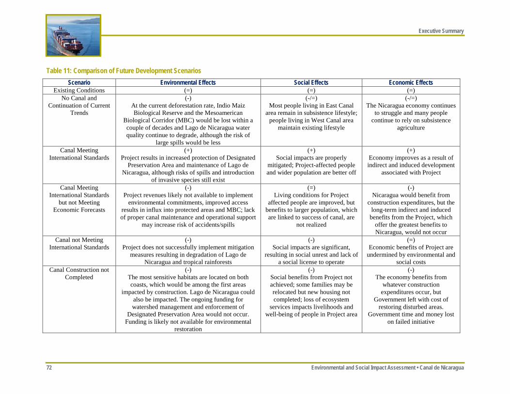
Executive Summary
72 Environmental and Social Impact Assessment • Canal de Nicaragua
Table 11: Comparison of Future Development Scenarios Scenario Environmental Effects Social Effects Economic Effects
Existing Conditions (=) (=) (=) No Canal and
Continuation of Current Trends
(-) At the current deforestation rate, Indio Maiz Biological Reserve and the Mesoamerican
Biological Corridor (MBC) would be lost within a couple of decades and Lago de Nicaragua water quality continue to degrade, although the risk of
large spills would be less
(-/=) Most people living in East Canal
area remain in subsistence lifestyle; people living in West Canal area
maintain existing lifestyle
(-/=) The Nicaragua economy continues
to struggle and many people continue to rely on subsistence
agriculture
Canal Meeting International Standards
(+) Project results in increased protection of Designated
Preservation Area and maintenance of Lago de Nicaragua, although risks of spills and introduction
of invasive species still exist
(+) Social impacts are properly
mitigated; Project-affected people and wider population are better off
(+) Economy improves as a result of indirect and induced development
associated with Project
Canal Meeting International Standards
but not Meeting Economic Forecasts
(-) Project revenues likely not available to implement
environmental commitments, improved access results in influx into protected areas and MBC; lack of proper canal maintenance and operational support
may increase risk of accidents/spills
(=) Living conditions for Project
affected people are improved, but benefits to larger population, which are linked to success of canal, are
not realized
(-) Nicaragua would benefit from
construction expenditures, but the long-term indirect and induced
benefits from the Project, which offer the greatest benefits to Nicaragua, would not occur
Canal not Meeting International Standards
(-) Project does not successfully implement mitigation
measures resulting in degradation of Lago de Nicaragua and tropical rainforests
(-) Social impacts are significant,
resulting in social unrest and lack of a social license to operate
(=) Economic benefits of Project are
undermined by environmental and social costs
Canal Construction not Completed
(-) The most sensitive habitats are located on both coasts, which would be among the first areas
impacted by construction. Lago de Nicaragua could also be impacted. The ongoing funding for watershed management and enforcement of
Designated Preservation Area would not occur. Funding is likely not available for environmental
restoration
(-) Social benefits from Project not achieved; some families may be relocated but new housing not completed; loss of ecosystem
services impacts livelihoods and well-being of people in Project area
(-) The economy benefits from
whatever construction expenditures occur, but
Government left with cost of restoring disturbed areas.
Government time and money lost on failed initiative
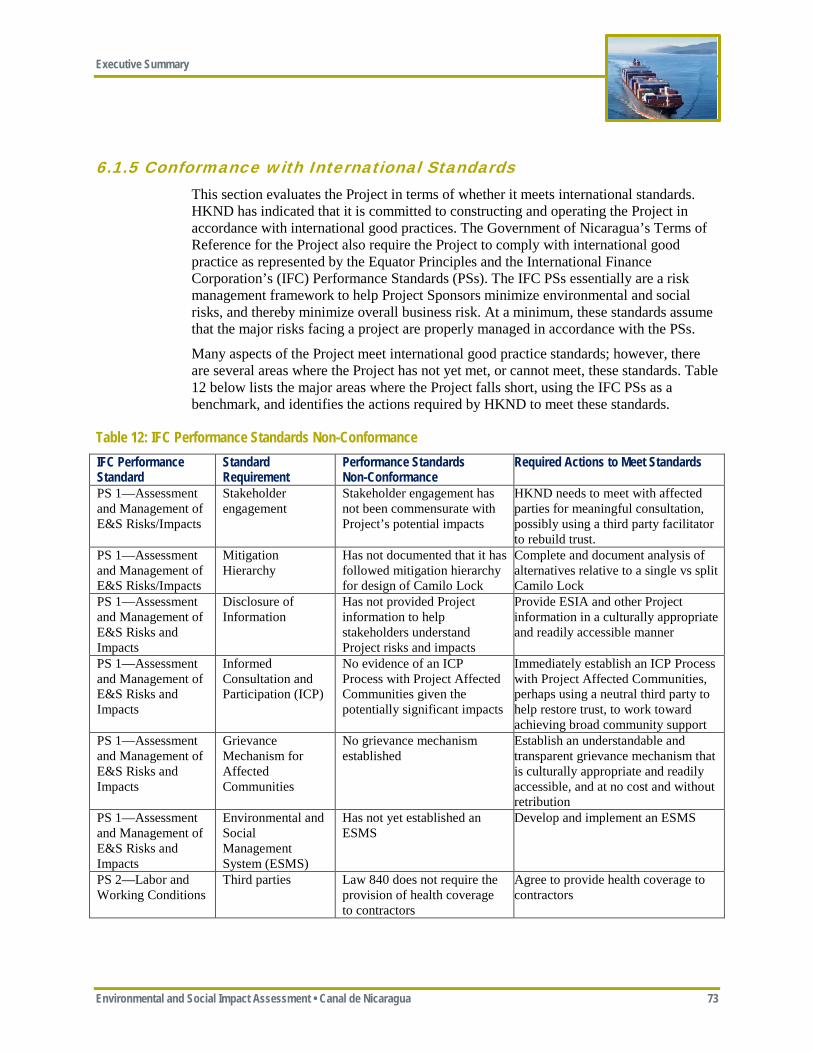
Executive Summary
Environmental and Social Impact Assessment • Canal de Nicaragua 73
6.1.5 Conformance with International Standards This section evaluates the Project in terms of whether it meets international standards. HKND has indicated that it is committed to constructing and operating the Project in accordance with international good practices. The Government of Nicaragua’s Terms of Reference for the Project also require the Project to comply with international good practice as represented by the Equator Principles and the International Finance Corporation’s (IFC) Performance Standards (PSs). The IFC PSs essentially are a risk management framework to help Project Sponsors minimize environmental and social risks, and thereby minimize overall business risk. At a minimum, these standards assume that the major risks facing a project are properly managed in accordance with the PSs.
Many aspects of the Project meet international good practice standards; however, there are several areas where the Project has not yet met, or cannot meet, these standards. Table 12 below lists the major areas where the Project falls short, using the IFC PSs as a benchmark, and identifies the actions required by HKND to meet these standards.
Table 12: IFC Performance Standards Non-Conformance IFC Performance Standard
Standard Requirement
Performance Standards Non-Conformance
Required Actions to Meet Standards
PS 1—Assessment and Management of E&S Risks/Impacts
Stakeholder engagement
Stakeholder engagement has not been commensurate with Project’s potential impacts
HKND needs to meet with affected parties for meaningful consultation, possibly using a third party facilitator to rebuild trust.
PS 1—Assessment and Management of E&S Risks/Impacts
Mitigation Hierarchy
Has not documented that it has followed mitigation hierarchy for design of Camilo Lock
Complete and document analysis of alternatives relative to a single vs split Camilo Lock
PS 1—Assessment and Management of E&S Risks and Impacts
Disclosure of Information
Has not provided Project information to help stakeholders understand Project risks and impacts
Provide ESIA and other Project information in a culturally appropriate and readily accessible manner
PS 1—Assessment and Management of E&S Risks and Impacts
Informed Consultation and Participation (ICP)
No evidence of an ICP Process with Project Affected Communities given the potentially significant impacts
Immediately establish an ICP Process with Project Affected Communities, perhaps using a neutral third party to help restore trust, to work toward achieving broad community support
PS 1—Assessment and Management of E&S Risks and Impacts
Grievance Mechanism for Affected Communities
No grievance mechanism established
Establish an understandable and transparent grievance mechanism that is culturally appropriate and readily accessible, and at no cost and without retribution
PS 1—Assessment and Management of E&S Risks and Impacts
Environmental and Social Management System (ESMS)
Has not yet established an ESMS
Develop and implement an ESMS
PS 2—Labor and Working Conditions
Third parties Law 840 does not require the provision of health coverage to contractors
Agree to provide health coverage to contractors
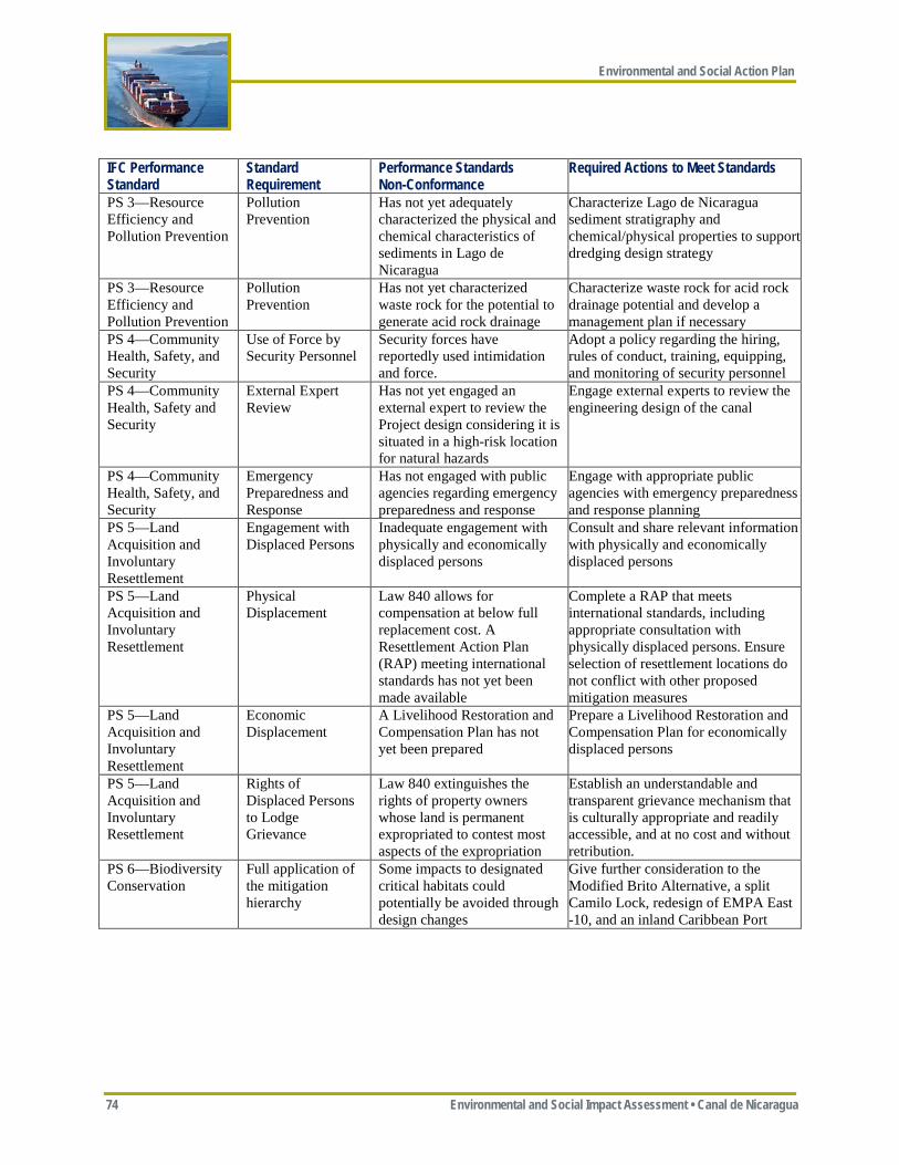
Environmental and Social Action Plan
74 Environmental and Social Impact Assessment • Canal de Nicaragua
IFC Performance Standard
Standard Requirement
Performance Standards Non-Conformance
Required Actions to Meet Standards
PS 3—Resource Efficiency and Pollution Prevention
Pollution Prevention
Has not yet adequately characterized the physical and chemical characteristics of sediments in Lago de Nicaragua
Characterize Lago de Nicaragua sediment stratigraphy and chemical/physical properties to support dredging design strategy
PS 3—Resource Efficiency and Pollution Prevention
Pollution Prevention
Has not yet characterized waste rock for the potential to generate acid rock drainage
Characterize waste rock for acid rock drainage potential and develop a management plan if necessary
PS 4—Community Health, Safety, and Security
Use of Force by Security Personnel
Security forces have reportedly used intimidation and force.
Adopt a policy regarding the hiring, rules of conduct, training, equipping, and monitoring of security personnel
PS 4—Community Health, Safety and Security
External Expert Review
Has not yet engaged an external expert to review the Project design considering it is situated in a high-risk location for natural hazards
Engage external experts to review the engineering design of the canal
PS 4—Community Health, Safety, and Security
Emergency Preparedness and Response
Has not engaged with public agencies regarding emergency preparedness and response
Engage with appropriate public agencies with emergency preparedness and response planning
PS 5—Land Acquisition and Involuntary Resettlement
Engagement with Displaced Persons
Inadequate engagement with physically and economically displaced persons
Consult and share relevant information with physically and economically displaced persons
PS 5—Land Acquisition and Involuntary Resettlement
Physical Displacement
Law 840 allows for compensation at below full replacement cost. A Resettlement Action Plan (RAP) meeting international standards has not yet been made available
Complete a RAP that meets international standards, including appropriate consultation with physically displaced persons. Ensure selection of resettlement locations do not conflict with other proposed mitigation measures
PS 5—Land Acquisition and Involuntary Resettlement
Economic Displacement
A Livelihood Restoration and Compensation Plan has not yet been prepared
Prepare a Livelihood Restoration and Compensation Plan for economically displaced persons
PS 5—Land Acquisition and Involuntary Resettlement
Rights of Displaced Persons to Lodge Grievance
Law 840 extinguishes the rights of property owners whose land is permanent expropriated to contest most aspects of the expropriation
Establish an understandable and transparent grievance mechanism that is culturally appropriate and readily accessible, and at no cost and without retribution.
PS 6—Biodiversity Conservation
Full application of the mitigation hierarchy
Some impacts to designated critical habitats could potentially be avoided through design changes
Give further consideration to the Modified Brito Alternative, a split Camilo Lock, redesign of EMPA East -10, and an inland Caribbean Port
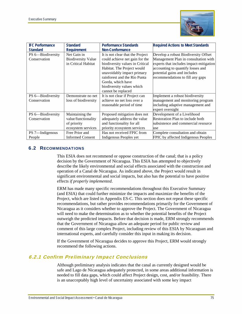
Executive Summary
Environmental and Social Impact Assessment • Canal de Nicaragua 75
IFC Performance Standard
Standard Requirement
Performance Standards Non-Conformance
Required Actions to Meet Standards
PS 6—Biodiversity Conservation
Net Gain in Biodiversity Value in Critical Habitat
It is not clear that the Project could achieve net gain for the biodiversity values in Critical Habitat. The Project would unavoidably impact primary rainforest and the Río Punta Gorda, which have biodiversity values which cannot be replaced
Develop a robust Biodiversity Offset Management Plan in consultation with experts that includes impact-mitigation accounting to quantify losses and potential gains and includes recommendations to fill any gaps
PS 6—Biodiversity Conservation
Demonstrate no net loss of biodiversity
It is not clear if Project can achieve no net loss over a reasonable period of time
Implement a robust biodiversity management and monitoring program including adaptive management and expert oversight
PS 6—Biodiversity Conservation
Maintaining the value/functionality of priority ecosystem services
Proposed mitigation does not adequately address the value and functionality for all priority ecosystem services
Development of a Livelihood Restoration Plan to include both subsistence and commercial resource use
PS 7—Indigenous People
Free Prior and Informed Consent
Has not received FPIC from Indigenous Peoples yet
Complete consultation and obtain FPIC by affected Indigenous Peoples
6.2 RECOMMENDATIONS This ESIA does not recommend or oppose construction of the canal; that is a policy decision by the Government of Nicaragua. This ESIA has attempted to objectively describe the likely environmental and social effects associated with the construction and operation of a Canal de Nicaragua. As indicated above, the Project would result in significant environmental and social impacts, but also has the potential to have positive effects if properly implemented.
ERM has made many specific recommendations throughout this Executive Summary (and ESIA) that could further minimize the impacts and maximize the benefits of the Project, which are listed in Appendix ES-C. This section does not repeat these specific recommendations, but rather provides recommendations primarily for the Government of Nicaragua as it considers whether to approve the Project. The Government of Nicaragua will need to make the determination as to whether the potential benefits of the Project outweigh the predicted impacts. Before that decision is made, ERM strongly recommends that the Government of Nicaragua allow an adequate period for public review and comment of this large complex Project, including review of this ESIA by Nicaraguan and international experts, and carefully consider this input in making its decision.
If the Government of Nicaragua decides to approve this Project, ERM would strongly recommend the following actions.
6.2.1 Confirm Preliminary Impact Conclusions Although preliminary analysis indicates that the canal as currently designed would be safe and Lago de Nicaragua adequately protected, in some areas additional information is needed to fill data gaps, which could affect Project design, cost, and/or feasibility. There is an unacceptably high level of uncertainty associated with some key impact

Environmental and Social Action Plan
76 Environmental and Social Impact Assessment • Canal de Nicaragua
conclusions. The following additional studies need to be completed to reduce uncertainty and confirm preliminary impact conclusions, especially regarding the important topics of canal safety and Lago de Nicaragua protection, before the Project receives final design approval and any construction begins: • Project Safety
o Complete geotechnical and seismic study to confirm the safety of the West Canal and Brito Lock; and
o Obtain accurate topography and re-evaluate the design of the Camilo Lock/ Lago Atlanta to confirm whether the impacts associated with Lago Atlanta could be reduced and the need for the Lago Atlanta Dike.
• Lago de Nicaragua o Complete an updated and more accurate water balance to confirm that sufficient
water is available to operate the canal without affecting Lago de Nicaragua water levels or Río San Juan outflow; and
o Conduct additional sediment borings and sampling in Lago de Nicaragua to better characterize the stratigraphy of the sediments and their physical and chemical properties to confirm the proposed dredging and disposal strategy would be effective.
The results of these studies should be made public and, depending on their results, may require modifications to the Project design and possibly supplements to this ESIA.
6.2.2 Optimize Project Design As indicated above, ERM considers that the proposed route is the preferred route, taking into consideration economic feasibility and environmental and social risks. Significant refinement of the exact alignment has already occurred, with HKND in several instances adopting alternatives that increased Project costs in order to avoid/reduce environmental and/or social impacts (e.g., avoiding the Town of El Tule). ERM does believe, however, that additional optimization of the design is possible and warranted in order to minimize environmental and social risks. It should be noted that ERM believes all of the following recommendations could be made within the existing expropriation boundary approved by the Government of Nicaragua, and would in some cases reduce the need for land expropriation.
HKND has indicated it would be willing to accept these three design modifications if acceptable to the Government of Nicaragua. ERM recommends that the Government of Nicaragua incorporate these changes into any approved project: • West Canal Pacific Entrance—shift canal alignment slightly further south
(approximately 200 meters) to minimize impacts on the Brito mangroves; • East Canal Caribbean Approach—shift the alignment slightly to the north (i.e., adopt
the El Corozo Alternative) in order to enhance the buffer to the Río Punta Gorda and associated riparian habitat and to improve overall canal constructability; and
• EMPAs—further avoid or minimize environmental and social impacts (e.g., on intact forest and small villages) associated with the location of EMPAs by optimizing their footprint and height, especially EMPA East-10, which currently impacts several endangered species.
Executive Summary
Environmental and Social Impact Assessment • Canal de Nicaragua 77
ERM has two other recommendations that are somewhat dependent on the outcome of proposed studies that are not yet complete: • West Canal Alignment—based on the results of the detailed seismic studies, and
especially if those studies identify a seismic risk associated with liquefaction, ERM recommends consideration of the Modified Brito Alternative alignment (see Figure 8), which would reduce the number of people who would need to be resettled, avoid the Nahoa indigenous lands, potentially reduce seismic risk, and possibly reduce construction costs when the costs of mitigating seismic risks are considered; and
• East Canal Lock—based on the updated water balance study and the more accurate topography, re-evaluate and optimize the location and design (single versus split) of the East Lock, with the goals of reducing the size and length of the Lago Atlanta Dike for safety reasons, reducing the surface area of Lago Atlanta for environmental and social reasons, minimizing salinity impacts above the lock, and maintaining negligible impacts on water levels in Lago de Nicaragua. It should be noted that it is not clear at this time whether a split lock design is feasible that would still maintain negligible impacts on water levels in Lago de Nicaragua.
The approximately 20 kilometers of the canal inland from the Caribbean coast traverses internationally important biodiversity areas (i.e., Mesoamerican Biological Corridor) and Rama-Kriol indigenous lands. Although the biodiversity and social impacts of canal construction in this area could at least potentially be mitigated or offset, the potentially greater risk posed by the Project would be related to the Águila Port and its access road. As Laurance et al. (2015) conclude, “the only viable, cost-effective way to ensure the integrity of natural areas is to ‘avoid the first cut’—keeping them road free.” The Águila Port and its access road would induce development and promote influx into this ecologically and culturally sensitive area. Therefore, ERM recommends that HKND and the Government of Nicaragua consider the following: • Relocate the Caribbean Port—from its current location along the Caribbean coast
near Punta Águila to Lago Atlanta, which would avoid significant impacts to marine habitat and relocation of the indigenous Bangkukuk Taik village, and significantly reduce the risk of influx into both indigenous territory and the Mesoamerican Biological Corridor by eliminating the port access road through this area. It should be noted that this design modification could potentially have a significant impact on the canal’s overall business case.
If this recommendation is not adopted, then strong measures by HKND and the Government of Nicaragua would be required to manage influx into this sensitive area and ERM recommends the area identified in Figure 20 be established as a Canal de Nicaragua Designated Preservation Area, within which no in-migration, logging, hunting/poaching, road construction, or other anthropogenic activities would be allowed, other than by the resident Indigenous Peoples. Any existing non-indigenous residents should be offered a voluntary resettlement package to relocate from this Designated Preservation Area.

Environmental and Social Action Plan
78 Environmental and Social Impact Assessment • Canal de Nicaragua
6.2.3 Obtain Expert Review This Project would be one of the largest civil works projects in the world, with segments being constructed in a seismically active, remote, and/or high precipitation areas, rich in biodiversity and a critical source of fresh water for Central America (i.e., Lago de Nicaragua), where a project failure would have significant consequences, all of which combine to make the design and construction of this Project a significant engineering feat. For these reasons, ERM recommends that the Government of Nicaragua establish an international expert panel to review the engineering design and constructability of the Project, especially relative to seismic hazards, water management, and failure modes for all main structures to ensure the protection of public safety and Lago de Nicaragua.
6.2.4 Project Governance The Project holds the potential for improving conditions in Nicaragua, but also carries with it many risks, which could in fact make conditions worse if not constructed or operated properly. It is therefore critical, if the Government of Nicaragua decides to approve this Project, that the Project be built in accordance with international standards and that all recommended mitigation and monitoring be implemented.
Not surprisingly, the issues, and mitigation measures associated with a project as large as the Canal de Nicaragua, go beyond the legal authority of HKND as the Project Sponsor to manage. Successful implementation of this Project would require the coordinated effort of HKND, the Government of Nicaragua, multilateral development agencies, and civil society organizations. The roles and responsibilities of each of these entities are briefly discussed below.
HKND’s Role and Responsibilities
HKND would be responsible for the Project’s environmental and social performance and assuring the implementation of its embedded controls and mitigation commitments and other conditions of any permit issued by the Government of Nicaragua. HKND, however, is a special purpose entity that was formed just for the Canal de Nicaragua Project. As would be expected, HKND has grown in terms of staff and capacity over the past 2 years since its creation in 2013. Nevertheless, HNKD needs to continue to expand its capacity in order to manage the construction of the Project and the implementation of its environmental and social commitments. Few companies have ever constructed anything comparable to the Canal de Nicaragua and HKND needs to develop the internal policies, procedures, standards, systems, and other mechanisms to provide assurance of its capacity to successfully complete an undertaking of this size and complexity. In order to demonstrate that it has the organizational capacity and competency to execute a project of this magnitude, HKND needs to: • Establish, adequately fund, and staff an organizational structure with qualified
personnel, and clearly defined roles, responsibilities, and authority in order to successfully meet its environmental and social responsibilities;
Executive Summary
Environmental and Social Impact Assessment • Canal de Nicaragua 79
• Continue to contract with national and international technical experts on key issues and reputable companies with the appropriate expertise in managing and constructing mega-projects to offset its lack of experience; and
• Establish an Environmental and Social Management System to systematically manage its environmental and social risks in a structured way on an ongoing basis.
Government of Nicaragua’s Role and Responsibilities
The Government of Nicaragua, through the Canal Commission, would be responsible for overseeing Project construction and operation and ensuring that the Project complies with all required conditions of any permit issued for the Project. Because of the magnitude of the Project and the nature of the Project risks, some of the proposed mitigation measures are beyond the legal authority of HKND to implement, so the Government of Nicaragua would have to accept responsibility for, or assist in implementing, some of these mitigation measures, presumably with funding support from HKND. The major measures requiring Government of Nicaragua action are listed below: • Establish and enforce protection of the Designated Preservation Area (see Figure 20); • Develop, in cooperation with relevant experts and stakeholders, a comprehensive
Lago de Nicaragua Management Plan to address current and anticipated threats to the lake’s water quality and overall integrity;
• Enhance existing protected areas containing mangrove and dry forest ecosystems proximate to the Project area (e.g., Chacocente Nature Reserve) and/or establish a new protected area (with associated management and enforcement support) in another similar mature mangrove/dry forest ecosystem outside the Project area to mitigate for impacts to dry forest and mangrove ecosystems in the Pacific region;
• Provide management and enforcement support for La Anciana Marine Reserve; • Establish Booby Cay as a Marine Protected Area; • Provide additional protection, management, and enforcement of turtle nesting
beaches near Brito, La Flor, Chacocente, and El Cocal; • Coordinate with HKND to implement an East Canal Watershed Management Plan,
similar to what has been done along the Panama Canal, to increase forest cover and reduce soil erosion while promoting sustainable development;
• Prepare, in cooperation with relevant experts, GTR-K, and other stakeholders, a Strategic Environmental Assessment (SEA) for the East Canal Project area to evaluate and then implement measures to further manage influx, preserve high value biodiversity areas, and protect the Rama-Kriol indigenous lands;
• Monitor population growth and coordinate with HKND to assist PACs in managing influx issues by providing training and funding to increase capacity of local infrastructure and services commensurate with the level of influx;
• Designate Pacific and Caribbean shipping lanes approaching the canal entrances to protect important marine resources; and
• Oversee expropriation of property and resettlement in accordance with international good practice.
Environmental and Social Action Plan
80 Environmental and Social Impact Assessment • Canal de Nicaragua
International Development Agency’s Role and Responsibilities
Like HKND, the Government of Nicaragua has not had experience with a project of this magnitude. In order for Nicaragua to fully realize the benefits of the Project, and to minimize environmental, social, and economic risks, the Government would be wise to consider engaging with international development agencies, such as the World Bank or Inter-American Development Bank, for assistance with capacity building for managing development issues (e.g., influx).
Civil Society’s Role and Responsibilities
ERM believes there is a role for civil society in this Project because there is a high level of mistrust in Nicaragua regarding the Project, which the involvement of an independent trusted third party could help overcome. Also, international standards recommend the use of external experts (e.g., NGOs or consultants) to review/monitor projects with significant impacts. ERM recommends that a third party provide independent oversight and verify Project monitoring and publicly issue a report at least semi-annually on the Project’s environmental and social performance. HKND should also consider funding participatory monitoring involving representatives from affected communities, which again would help restore trust and rebuild relationships with affected communities.
6.2.5 Require Conditions of Approval If the Government of Nicaragua decides to approve this Project, ERM strongly recommends the following as conditions of any approval: • Require HKND to implement the measures included in the ESAP in accordance with
the identified schedule (Appendix ES-A); • Require HKND’s proposed embedded controls and the mitigation measures identified
in this ESIA, as well as any additional measures the Government of Nicaragua deems appropriate, as a condition of any approval or permit, as the significance of the predicted impacts described in this ESIA are dependent on the proper implementation of these proposed mitigation measures. If these mitigation measures are not implemented, the impacts described in this ESIA would likely be significantly worse. Appendix ES-B provides a registry of proposed mitigation measures;
• Require that HKND includes compliance with these mitigation measures and any other government-imposed conditions of approval in all contracts with construction firms such that these firms can be held to the same requirements as HKND;
• Require a robust monitoring program with at least annual reporting and third-party independent oversight to ensure that the canal is being constructed in accordance with approved plans, that required mitigation is being properly provided, and adaptive management measures are applied if monitoring shows that the provided mitigation measures are not effective in protecting important resources/receptors; and
• Require HKND to demonstrate that it has the financial ability to construct the entire canal and implement the recommended mitigation and offset measures, or, if sufficient financial ability cannot be demonstrated, provide financial assurance (e.g., surety bonds, irrevocable letters of credit, trust funds, insurance policies) that the Government of Nicaragua could access in order to either complete construction of the canal or properly and safely restore disturbed areas.
Environmental and Social Action Plan
Environmental and Social Impact Assessment • Canal de Nicaragua 81
Appendix ES-A—Environmental and Social Action Plan
Environmental and Social Action Plan
82 Environmental and Social Impact Assessment • Canal de Nicaragua
-Page Intentionally Left Blank-
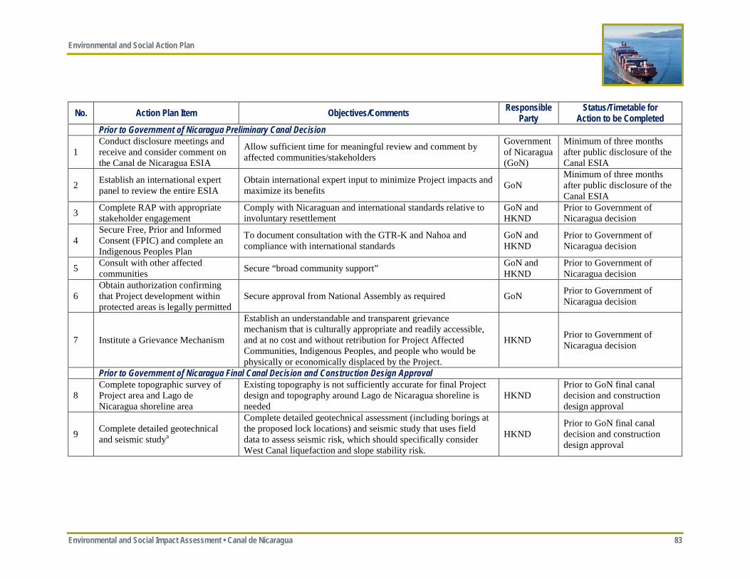
Environmental and Social Action Plan
Environmental and Social Impact Assessment • Canal de Nicaragua 83
No. Action Plan Item Objectives/Comments Responsible Party
Status/Timetable for Action to be Completed
Prior to Government of Nicaragua Preliminary Canal Decision
1 Conduct disclosure meetings and receive and consider comment on the Canal de Nicaragua ESIA
Allow sufficient time for meaningful review and comment by affected communities/stakeholders
Government of Nicaragua (GoN)
Minimum of three months after public disclosure of the Canal ESIA
2 Establish an international expert panel to review the entire ESIA
Obtain international expert input to minimize Project impacts and maximize its benefits GoN
Minimum of three months after public disclosure of the Canal ESIA
3 Complete RAP with appropriate stakeholder engagement
Comply with Nicaraguan and international standards relative to involuntary resettlement
GoN and HKND
Prior to Government of Nicaragua decision
4 Secure Free, Prior and Informed Consent (FPIC) and complete an Indigenous Peoples Plan
To document consultation with the GTR-K and Nahoa and compliance with international standards
GoN and HKND
Prior to Government of Nicaragua decision
5 Consult with other affected communities Secure “broad community support” GoN and
HKND Prior to Government of Nicaragua decision
6 Obtain authorization confirming that Project development within protected areas is legally permitted
Secure approval from National Assembly as required GoN Prior to Government of Nicaragua decision
7 Institute a Grievance Mechanism
Establish an understandable and transparent grievance mechanism that is culturally appropriate and readily accessible, and at no cost and without retribution for Project Affected Communities, Indigenous Peoples, and people who would be physically or economically displaced by the Project.
HKND Prior to Government of Nicaragua decision
Prior to Government of Nicaragua Final Canal Decision and Construction Design Approval
8 Complete topographic survey of Project area and Lago de Nicaragua shoreline area
Existing topography is not sufficiently accurate for final Project design and topography around Lago de Nicaragua shoreline is needed
HKND Prior to GoN final canal decision and construction design approval
9 Complete detailed geotechnical and seismic studya
Complete detailed geotechnical assessment (including borings at the proposed lock locations) and seismic study that uses field data to assess seismic risk, which should specifically consider West Canal liquefaction and slope stability risk.
HKND Prior to GoN final canal decision and construction design approval
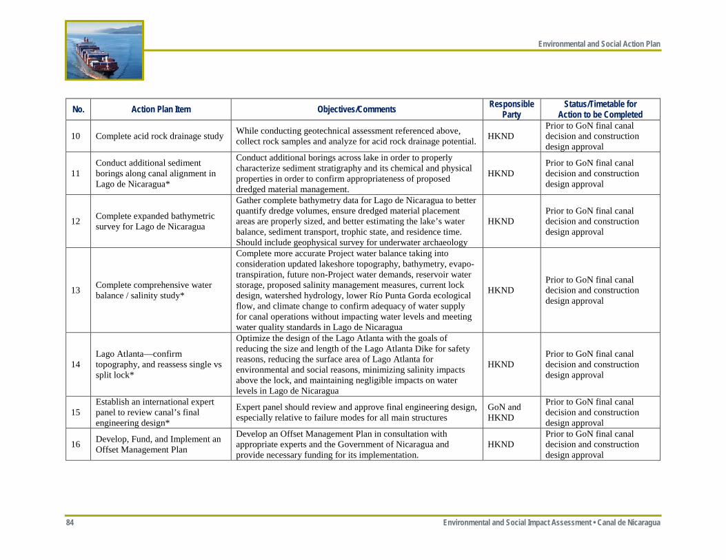
Environmental and Social Action Plan
84 Environmental and Social Impact Assessment • Canal de Nicaragua
No. Action Plan Item Objectives/Comments Responsible Party
Status/Timetable for Action to be Completed
10 Complete acid rock drainage study While conducting geotechnical assessment referenced above, collect rock samples and analyze for acid rock drainage potential. HKND
Prior to GoN final canal decision and construction design approval
11 Conduct additional sediment borings along canal alignment in Lago de Nicaragua*
Conduct additional borings across lake in order to properly characterize sediment stratigraphy and its chemical and physical properties in order to confirm appropriateness of proposed dredged material management.
HKND Prior to GoN final canal decision and construction design approval
12 Complete expanded bathymetric survey for Lago de Nicaragua
Gather complete bathymetry data for Lago de Nicaragua to better quantify dredge volumes, ensure dredged material placement areas are properly sized, and better estimating the lake’s water balance, sediment transport, trophic state, and residence time. Should include geophysical survey for underwater archaeology
HKND Prior to GoN final canal decision and construction design approval
13 Complete comprehensive water balance / salinity study*
Complete more accurate Project water balance taking into consideration updated lakeshore topography, bathymetry, evapo-transpiration, future non-Project water demands, reservoir water storage, proposed salinity management measures, current lock design, watershed hydrology, lower Río Punta Gorda ecological flow, and climate change to confirm adequacy of water supply for canal operations without impacting water levels and meeting water quality standards in Lago de Nicaragua
HKND Prior to GoN final canal decision and construction design approval
14 Lago Atlanta—confirm topography, and reassess single vs split lock*
Optimize the design of the Lago Atlanta with the goals of reducing the size and length of the Lago Atlanta Dike for safety reasons, reducing the surface area of Lago Atlanta for environmental and social reasons, minimizing salinity impacts above the lock, and maintaining negligible impacts on water levels in Lago de Nicaragua
HKND Prior to GoN final canal decision and construction design approval
15 Establish an international expert panel to review canal’s final engineering design*
Expert panel should review and approve final engineering design, especially relative to failure modes for all main structures
GoN and HKND
Prior to GoN final canal decision and construction design approval
16 Develop, Fund, and Implement an Offset Management Plan
Develop an Offset Management Plan in consultation with appropriate experts and the Government of Nicaragua and provide necessary funding for its implementation.
HKND Prior to GoN final canal decision and construction design approval
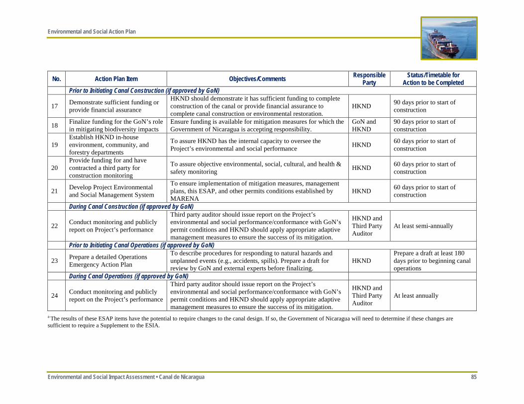
Environmental and Social Action Plan
Environmental and Social Impact Assessment • Canal de Nicaragua 85
No. Action Plan Item Objectives/Comments Responsible Party
Status/Timetable for Action to be Completed
Prior to Initiating Canal Construction (if approved by GoN)
17 Demonstrate sufficient funding or provide financial assurance
HKND should demonstrate it has sufficient funding to complete construction of the canal or provide financial assurance to complete canal construction or environmental restoration.
HKND 90 days prior to start of construction
18 Finalize funding for the GoN’s role in mitigating biodiversity impacts
Ensure funding is available for mitigation measures for which the Government of Nicaragua is accepting responsibility.
GoN and HKND
90 days prior to start of construction
19 Establish HKND in-house environment, community, and forestry departments
To assure HKND has the internal capacity to oversee the Project’s environmental and social performance HKND 60 days prior to start of
construction
20 Provide funding for and have contracted a third party for construction monitoring
To assure objective environmental, social, cultural, and health & safety monitoring HKND 60 days prior to start of
construction
21 Develop Project Environmental and Social Management System
To ensure implementation of mitigation measures, management plans, this ESAP, and other permits conditions established by MARENA
HKND 60 days prior to start of construction
During Canal Construction (if approved by GoN)
22 Conduct monitoring and publicly report on Project’s performance
Third party auditor should issue report on the Project’s environmental and social performance/conformance with GoN’s permit conditions and HKND should apply appropriate adaptive management measures to ensure the success of its mitigation.
HKND and Third Party Auditor
At least semi-annually
Prior to Initiating Canal Operations (if approved by GoN)
23 Prepare a detailed Operations Emergency Action Plan
To describe procedures for responding to natural hazards and unplanned events (e.g., accidents, spills). Prepare a draft for review by GoN and external experts before finalizing.
HKND Prepare a draft at least 180 days prior to beginning canal operations
During Canal Operations (if approved by GoN)
24 Conduct monitoring and publicly report on the Project’s performance
Third party auditor should issue report on the Project’s environmental and social performance/conformance with GoN’s permit conditions and HKND should apply appropriate adaptive management measures to ensure the success of its mitigation.
HKND and Third Party Auditor
At least annually
a The results of these ESAP items have the potential to require changes to the canal design. If so, the Government of Nicaragua will need to determine if these changes are sufficient to require a Supplement to the ESIA.
Environmental and Social Action Plan
86 Environmental and Social Impact Assessment • Canal de Nicaragua
-Page Intentionally Left Blank-
HKND Commitment Registry
Environmental and Social Impact Assessment • Canal de Nicaragua 87
Appendix ES-B—HKND Commitment Registry
HKND Commitment Registry
88 Environmental and Social Impact Assessment
-Page Intentionally Left Blank-
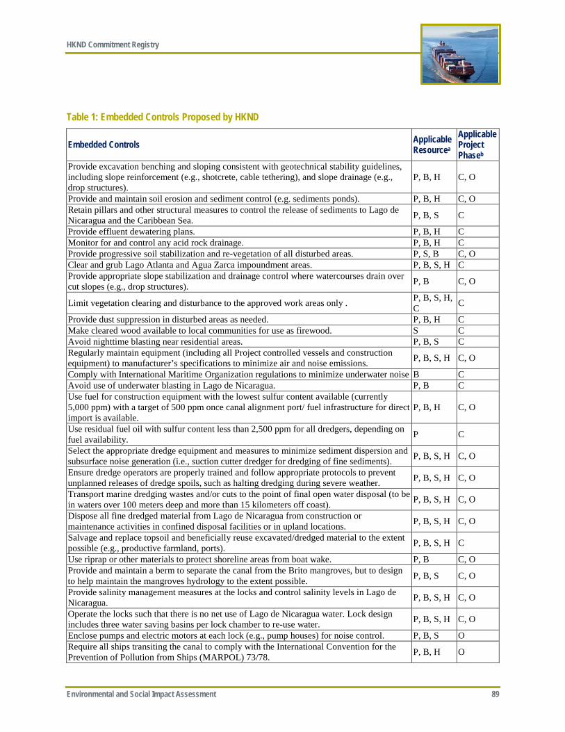
HKND Commitment Registry
Environmental and Social Impact Assessment 89
Table 1: Embedded Controls Proposed by HKND
Embedded Controls Applicable Resourcea
Applicable Project Phaseb
Provide excavation benching and sloping consistent with geotechnical stability guidelines, including slope reinforcement (e.g., shotcrete, cable tethering), and slope drainage (e.g., drop structures).
P, B, H C, O
Provide and maintain soil erosion and sediment control (e.g. sediments ponds). P, B, H C, O Retain pillars and other structural measures to control the release of sediments to Lago de Nicaragua and the Caribbean Sea. P, B, S C
Provide effluent dewatering plans. P, B, H C Monitor for and control any acid rock drainage. P, B, H C Provide progressive soil stabilization and re-vegetation of all disturbed areas. P, S, B C, O Clear and grub Lago Atlanta and Agua Zarca impoundment areas. P, B, S, H C Provide appropriate slope stabilization and drainage control where watercourses drain over cut slopes (e.g., drop structures). P, B C, O
Limit vegetation clearing and disturbance to the approved work areas only . P, B, S, H, C C
Provide dust suppression in disturbed areas as needed. P, B, H C Make cleared wood available to local communities for use as firewood. S C Avoid nighttime blasting near residential areas. P, B, S C Regularly maintain equipment (including all Project controlled vessels and construction equipment) to manufacturer’s specifications to minimize air and noise emissions. P, B, S, H C, O
Comply with International Maritime Organization regulations to minimize underwater noise B C Avoid use of underwater blasting in Lago de Nicaragua. P, B C Use fuel for construction equipment with the lowest sulfur con tent available (currently 5,000 ppm) with a target of 500 ppm once canal alignment port/ fuel infrastructure for direct import is available.
P, B, H C, O
Use residual fuel oil with sulfur content less than 2,500 ppm for all dredgers, depending on fuel availability. P C
Select the appropriate dredge equipment and measures to minimize sediment dispersion and subsurface noise generation (i.e., suction cutter dredger for dredging of fine sediments). P, B, S, H C, O
Ensure dredge operators are properly trained and follow appropriate protocols to prevent unplanned releases of dredge spoils, such as halting dredging during severe weather. P, B, S, H C, O
Transport marine dredging wastes and/or cuts to the point of final open water disposal (to be in waters over 100 meters deep and more than 15 kilometers off coast). P, B, S, H C, O
Dispose all fine dredged material from Lago de Nicaragua from construction or maintenance activities in confined disposal facilities or in upland locations. P, B, S, H C, O
Salvage and replace topsoil and beneficially reuse excavated/dredged material to the extent possible (e.g., productive farmland, ports). P, B, S, H C
Use riprap or other materials to protect shoreline areas from boat wake. P, B C, O Provide and maintain a berm to separate the canal from the Brito mangroves, but to design to help maintain the mangroves hydrology to the extent possible. P, B, S C, O
Provide salinity management measures at the locks and control salinity levels in Lago de Nicaragua. P, B, S, H C, O
Operate the locks such that there is no net use of Lago de Nicaragua water. Lock design includes three water saving basins per lock chamber to re-use water. P, B, S, H C, O
Enclose pumps and electric motors at each lock (e.g., pump houses) for noise control. P, B, S O Require all ships transiting the canal to comply with the International Convention for the Prevention of Pollution from Ships (MARPOL) 73/78. P, B, H O
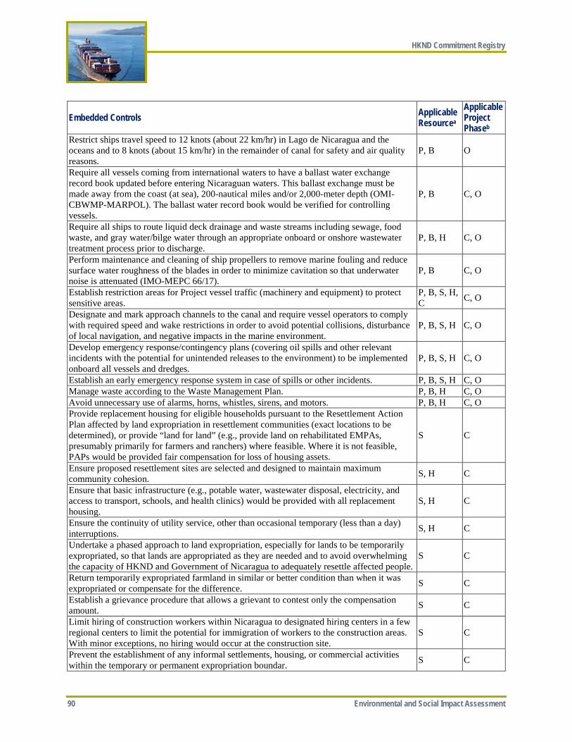
HKND Commitment Registry
90 Environmental and Social Impact Assessment
Embedded Controls Applicable Resourcea
Applicable Project Phaseb
Restrict ships travel speed to 12 knots (about 22 km/hr) in Lago de Nicaragua and the oceans and to 8 knots (about 15 km/hr) in the remainder of canal for safety and air quality reasons.
P, B O
Require all vessels coming from international waters to have a ballast water exchange record book updated before entering Nicaraguan waters. This ballast exchange must be made away from the coast (at sea), 200-nautical miles and/or 2,000-meter depth (OMI-CBWMP-MARPOL). The ballast water record book would be verified for controlling vessels.
P, B C, O
Require all ships to route liquid deck drainage and waste streams including sewage, food waste, and gray water/bilge water through an appropriate onboard or onshore wastewater treatment process prior to discharge.
P, B, H C, O
Perform maintenance and cleaning of ship propellers to remove marine fouling and reduce surface water roughness of the blades in order to minimize cavitation so that underwater noise is attenuated (IMO-MEPC 66/17).
P, B C, O
Establish restriction areas for Project vessel traffic (machinery and equipment) to protect sensitive areas.
P, B, S, H, C C, O
Designate and mark approach channels to the canal and require vessel operators to comply with required speed and wake restrictions in order to avoid potential collisions, disturbance of local navigation, and negative impacts in the marine environment.
P, B, S, H C, O
Develop emergency response/contingency plans (covering oil spills and other relevant incidents with the potential for unintended releases to the environment) to be implemented onboard all vessels and dredges.
P, B, S, H C, O
Establish an early emergency response system in case of spills or other incidents. P, B, S, H C, O Manage waste according to the Waste Management Plan. P, B, H C, O Avoid unnecessary use of alarms, horns, whistles, sirens, and motors. P, B, H C, O Provide replacement housing for eligible households pursuant to the Resettlement Action Plan affected by land expropriation in resettlement communities (exact locations to be determined), or provide “land for land” (e.g., provide land on rehabilitated EMPAs, presumably primarily for farmers and ranchers) where feasible. Where it is not feasible, PAPs would be provided fair compensation for loss of housing assets.
S C
Ensure proposed resettlement sites are selected and designed to maintain maximum community cohesion. S, H C
Ensure that basic infrastructure (e.g., potable water, wastewater disposal, electricity, and access to transport, schools, and health clinics) would be provided with all replacement housing.
S, H C
Ensure the continuity of utility service, other than occasional temporary (less than a day) interruptions. S, H C
Undertake a phased approach to land expropriation, especially for lands to be temporarily expropriated, so that lands are appropriated as they are needed and to avoid overwhelming the capacity of HKND and Government of Nicaragua to adequately resettle affected people.
S C
Return temporarily expropriated farmland in similar or better condition than when it was expropriated or compensate for the difference. S C
Establish a grievance procedure that allows a grievant to contest only the compensation amount. S C
Limit hiring of construction workers within Nicaragua to designated hiring centers in a few regional centers to limit the potential for immigration of workers to the construction areas. With minor exceptions, no hiring would occur at the construction site.
S C
Prevent the establishment of any informal settlements, housing, or commercial activities within the temporary or permanent expropriation boundar. S C
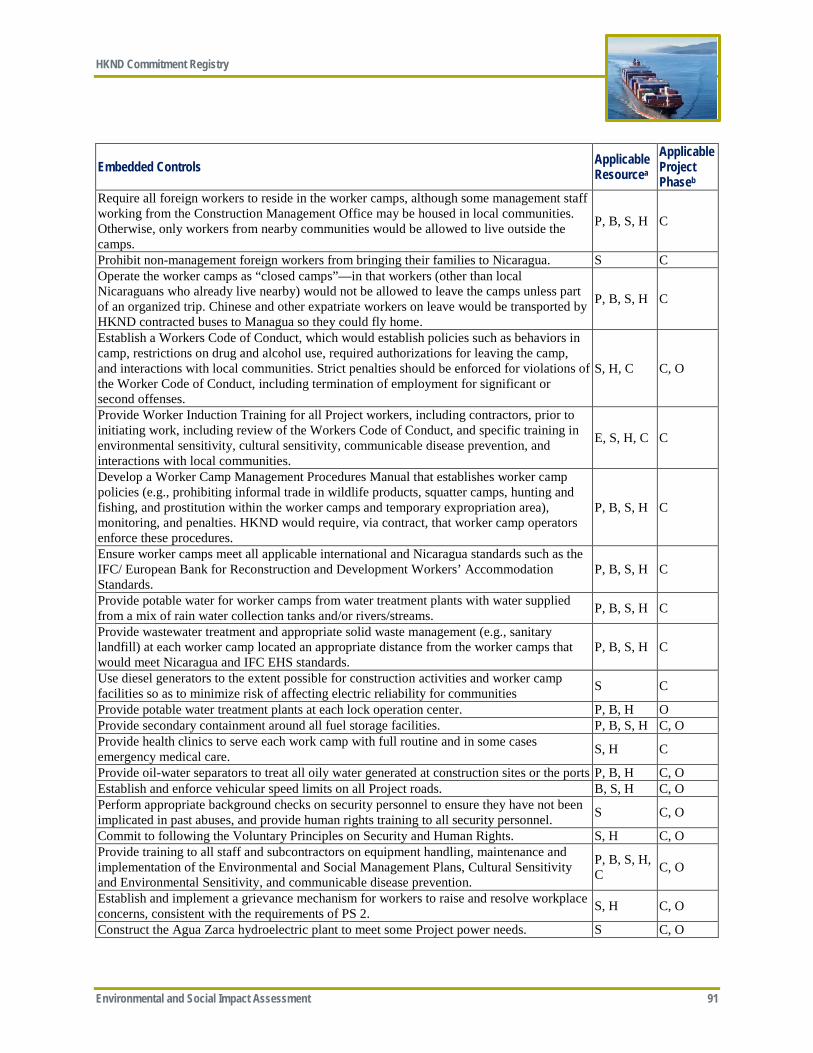
HKND Commitment Registry
Environmental and Social Impact Assessment 91
Embedded Controls Applicable Resourcea
Applicable Project Phaseb
Require all foreign workers to reside in the worker camps, although some management staff working from the Construction Management Office may be housed in local communities. Otherwise, only workers from nearby communities would be allowed to live outside the camps.
P, B, S, H C
Prohibit non-management foreign workers from bringing their families to Nicaragua. S C Operate the worker camps as “closed camps”—in that workers (other than local Nicaraguans who already live nearby) would not be allowed to leave the camps unless part of an organized trip. Chinese and other expatriate workers on leave would be transported by HKND contracted buses to Managua so they could fly home.
P, B, S, H C
Establish a Workers Code of Conduct, which would establish policies such as behaviors in camp, restrictions on drug and alcohol use, required authorizations for leaving the camp, and interactions with local communities. Strict penalties should be enforced for violations of the Worker Code of Conduct, including termination of employment for significant or second offenses.
S, H, C C, O
Provide Worker Induction Training for all Project workers, including contractors, prior to initiating work, including review of the Workers Code of Conduct, and specific training in environmental sensitivity, cultural sensitivity, communicable disease prevention, and interactions with local communities.
E, S, H, C C
Develop a Worker Camp Management Procedures Manual that establishes worker camp policies (e.g., prohibiting informal trade in wildlife products, squatter camps, hunting and fishing, and prostitution within the worker camps and temporary expropriation area), monitoring, and penalties. HKND would require, via contract, that worker camp operators enforce these procedures.
P, B, S, H C
Ensure worker camps meet all applicable international and Nicaragua standards such as the IFC/ European Bank for Reconstruction and Development Workers’ Accommodation Standards.
P, B, S, H C
Provide potable water for worker camps from water treatment plants with water supplied from a mix of rain water collection tanks and/or rivers/streams. P, B, S, H C
Provide wastewater treatment and appropriate solid waste management (e.g., sanitary landfill) at each worker camp located an appropriate distance from the worker camps that would meet Nicaragua and IFC EHS standards.
P, B, S, H C
Use diesel generators to the extent possible for construction activities and worker camp facilities so as to minimize risk of affecting electric reliability for communities S C
Provide potable water treatment plants at each lock operation center. P, B, H O Provide secondary containment around all fuel storage facilities. P, B, S, H C, O Provide health clinics to serve each work camp with full routine and in some cases emergency medical care. S, H C
Provide oil-water separators to treat all oily water generated at construction sites or the ports P, B, H C, O Establish and enforce vehicular speed limits on all Project roads. B, S, H C, O Perform appropriate background checks on security personnel to ensure they have not been implicated in past abuses, and provide human rights training to all security personnel. S C, O
Commit to following the Voluntary Principles on Security and Human Rights. S, H C, O Provide training to all staff and subcontractors on equipment handling, maintenance and implementation of the Environmental and Social Management Plans, Cultural Sensitivity and Environmental Sensitivity, and communicable disease prevention.
P, B, S, H, C C, O
Establish and implement a grievance mechanism for workers to raise and resolve workplace concerns, consistent with the requirements of PS 2. S, H C, O
Construct the Agua Zarca hydroelectric plant to meet some Project power needs. S C, O
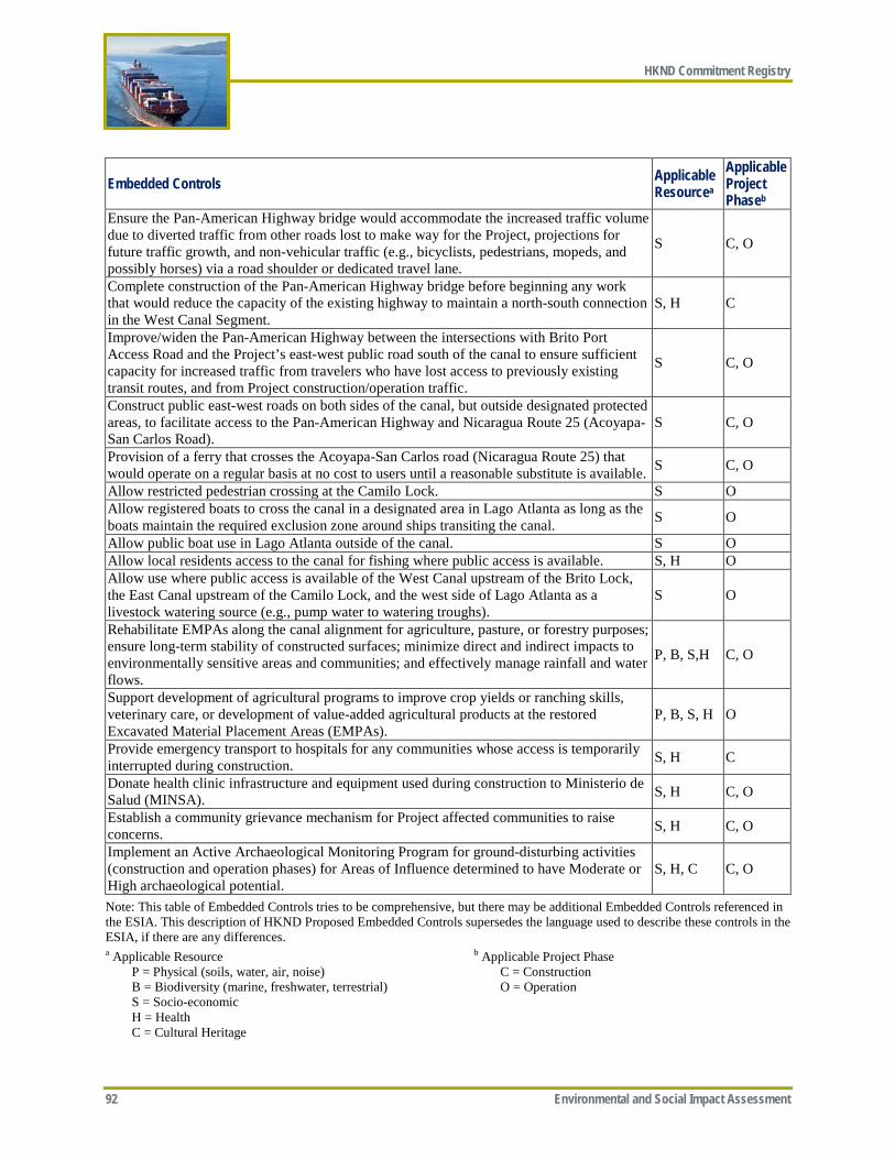
HKND Commitment Registry
92 Environmental and Social Impact Assessment
Embedded Controls Applicable Resourcea
Applicable Project Phaseb
Ensure the Pan-American Highway bridge would accommodate the increased traffic volume due to diverted traffic from other roads lost to make way for the Project, projections for future traffic growth, and non-vehicular traffic (e.g., bicyclists, pedestrians, mopeds, and possibly horses) via a road shoulder or dedicated travel lane.
S C, O
Complete construction of the Pan-American Highway bridge before beginning any work that would reduce the capacity of the existing highway to maintain a north-south connection in the West Canal Segment.
S, H C
Improve/widen the Pan-American Highway between the intersections with Brito Port Access Road and the Project’s east-west public road south of the canal to ensure sufficient capacity for increased traffic from travelers who have lost access to previously existing transit routes, and from Project construction/operation traffic.
S C, O
Construct public east-west roads on both sides of the canal, but outside designated protected areas, to facilitate access to the Pan-American Highway and Nicaragua Route 25 (Acoyapa-San Carlos Road).
S C, O
Provision of a ferry that crosses the Acoyapa-San Carlos road (Nicaragua Route 25) that would operate on a regular basis at no cost to users until a reasonable substitute is available. S C, O
Allow restricted pedestrian crossing at the Camilo Lock. S O Allow registered boats to cross the canal in a designated area in Lago Atlanta as long as the boats maintain the required exclusion zone around ships transiting the canal. S O
Allow public boat use in Lago Atlanta outside of the canal. S O Allow local residents access to the canal for fishing where public access is available. S, H O Allow use where public access is available of the West Canal upstream of the Brito Lock, the East Canal upstream of the Camilo Lock, and the west side of Lago Atlanta as a livestock watering source (e.g., pump water to watering troughs).
S O
Rehabilitate EMPAs along the canal alignment for agriculture, pasture, or forestry purposes; ensure long-term stability of constructed surfaces; minimize direct and indirect impacts to environmentally sensitive areas and communities; and effectively manage rainfall and water flows.
P, B, S,H C, O
Support development of agricultural programs to improve crop yields or ranching skills, veterinary care, or development of value-added agricultural products at the restored Excavated Material Placement Areas (EMPAs).
P, B, S, H O
Provide emergency transport to hospitals for any communities whose access is temporarily interrupted during construction. S, H C
Donate health clinic infrastructure and equipment used during construction to Ministerio de Salud (MINSA). S, H C, O
Establish a community grievance mechanism for Project affected communities to raise concerns. S, H C, O
Implement an Active Archaeological Monitoring Program for ground-disturbing activities (construction and operation phases) for Areas of Influence determined to have Moderate or High archaeological potential.
S, H, C C, O
Note: This table of Embedded Controls tries to be comprehensive, but there may be additional Embedded Controls referenced in the ESIA. This description of HKND Proposed Embedded Controls supersedes the language used to describe these controls in the ESIA, if there are any differences. a Applicable Resource P = Physical (soils, water, air, noise) B = Biodiversity (marine, freshwater, terrestrial) S = Socio-economic H = Health C = Cultural Heritage
b Applicable Project Phase C = Construction O = Operation

ERM-Recommended Additional Mitigation Measures
Environmental and Social Impact Assessment 93
Table 2: HKND-Approved Mitigation Measures Geology and Hydrogeology
• Develop alternative potable water supply sources for impacted groundwater users.
Geomorphology and Soils
• Collect seed and plant stock from the areas to be disturbed before the start of construction activities, for use in the revegetation effort.
• Collaborate with the Ministerio de Agricultura y Ganaderia and with Nicaraguan Universities Agricultural Research Centers to test procedures for reclaiming areas to be revegetated (e.g., determine what soil amendments would be needed and what native species would grow best) and explore starting plant nurseries to propagate the collected seed and plant stock.
• Develop an Agricultural Management Plan for areas where agricultural topsoil is placed • Develop a detailed Soil Erosion and Sedimentation Control Plan as part of final design. • Develop a robust East Canal Watershed Management Plan, which should be linked to
reforestation efforts, to control sediment and nutrient transport to the canal and Lago de Nicaragua.
Water Resources • Provide breakwaters at canal entrances for ship guidance and shoreline protection. • Conduct beach renourishment for Brito Beach and Caribbean beaches. • Conduct adaptive management relative to beach erosion or sediment transport along
both the Pacific and Caribbean coasts in the Project area. • Provide engineered drainage and controlled release of water from cut slopes along the
canal. • In coordination with the Government of Nicaragua, develop a multi-objective,
comprehensive Lago de Nicaragua Management Plan that addresses issues related to the Project, including identifying measures to control nutrient and sediment loading to Lago de Nicaragua.
• In coordination with the Government of Nicaragua, implement land use controls within HKND's permanent expropriation boundary for lands surrounding for Agua Zarca Reservoir and Lago Atlanta to maintain forests and reduce nutrient and sediment loadings.
Air Quality and Greenhouse Gases
• Implement solid waste management plan. • Minimize burning of non-vegetative wastes (e.g., refuse) and cleared wood at
construction sites and only in a controlled manner. Noise • Sub-divide explosive charges.
• Avoid blasting during unfavorable atmospheric conditions. Biodiversity—General Recommendations
• As part of the construction workforce induction environmental sensitivity training and Worker Code of Conduct (for both employees and contractors), ensure that all relevant personnel are trained regarding the importance of endangered species and their conservation, required mitigation measures, and the prohibition on hunting /poaching, fishing, or trade of any natural or wildlife products.
• Require, via subcontract, that worker camp operators strictly abide by and enforce the Camp Management Procedures, which would strictly prohibit possession of firearms; and the hunting, fishing, or purchasing of any natural or wildlife products. Purchasing of food for construction workers should come from domesticated livestock, agricultural crops, and sustainably harvested fisheries. Impose suitable penalties, enforce through security checks, with third party monitoring.
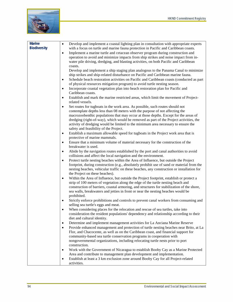
HKND Commitment Registry
94 Environmental and Social Impact Assessment
Marine Biodiversity
• Develop and implement a coastal lighting plan in consultation with appropriate experts with a focus on turtle and marine fauna protection in Pacific and Caribbean coasts.
• Implement a marine turtle and cetacean observer program during construction and operation to avoid and minimize impacts from ship strikes and noise impact from in-water pile driving, dredging, and blasting activities, on both Pacific and Caribbean coasts. Develop and implement a ship staging plan analogous to the Panama Canal to minimize ship strikes and ship-related disturbance on Pacific and Caribbean marine fauna.
• Schedule beach restoration activities on Pacific and Caribbean coasts (conducted as part of physical resources mitigation program) to avoid turtle nesting season.
• Incorporate coastal vegetation plan into beach restoration plan for Pacific and Caribbean coasts.
• Establish and mark the marine restricted areas, which limit the movement of Project-related vessels.
• Set routes for tugboats in the work area. As possible, such routes should not contemplate depths less than 08 meters with the purpose of not affecting the macrozoobenthic populations that may occur at those depths. Except for the areas of dredging (right-of-way), which would be removed as part of the Project activities, the activity of dredging would be limited to the minimum area necessary to ensure the safety and feasibility of the Project.
• Establish a maximum allowable speed for tugboats in the Project work area that is protective of marine mammals.
• Ensure that a minimum volume of material necessary for the construction of the breakwater is used.
• Abide by the navigation routes established by the port and canal authorities to avoid collisions and affect the local navigation and the environment.
• Protect turtle nesting beaches within the Area of Influence, but outside the Project footprint, during construction (e.g., absolutely prohibit use of sand or material from the nesting beaches, vehicular traffic on these beaches, any construction or installation for the Project on these beaches).
• Within the Area of Influence, but outside the Project footprint, establish or protect a strip of 100 meters of vegetation along the edge of the turtle nesting beach and construction of barriers, coastal armoring, and structures for stabilization of the shore, sea walls, breakwaters and jetties in front or near the nesting beaches would be prohibited.
• Strictly enforce prohibitions and controls to prevent canal workers from consuming and selling sea turtle's eggs and meat.
• When considering places for the relocation and rescue of sea turtles, take into consideration the resident populations' dependency and relationship according to their diet and cultural identity.
• Determine and implement management activities for La Anciana Marine Reserve • Provide enhanced management and protection of turtle nesting beaches near Brito, at La
Flor, and Chacocente, as well as on the Caribbean coast, and financial support for community-based sea turtle conservation programs in cooperation with nongovernmental organizations, including relocating turtle nests prior to port construction.
• Work with the Government of Nicaragua to establish Booby Cay as a Marine Protected Area and contribute to management plan development and implementation.
• Establish at least a 3 km exclusion zone around Booby Cay for all Project-related activities.
ERM-Recommended Additional Mitigation Measures
Environmental and Social Impact Assessment 95
Freshwater Biodiversity
• Implement sediment control procedures where natural waterways would persist downstream of EMPAs as these facilities are dewatered to minimize the release of fine sediments to remaining natural waterways.
• Optimize the EMPA design to further reduce direct losses of stream channels • Restore/reforest EMPAs to improve water quality and reduce flow velocity of water
entering downstream habitats. • Provide fish passage for migratory aquatic species in conjunction with drop structures
where six to eight larger perennial streams would join the canal (i.e., essentially at locations where the EMPAs preserve existing stream channels).
• Manage hydrology to preserve remnant Brito mangroves. • Place road crossings on straight sections of stream when possible. This design feature
allows the flow to dissipate within the channel while it is moving parallel to the shoreline. This is desirable compared to placing a crossing immediately upstream of a bend in the channel, which would cause erosion of the outside bend of the stream channel.
• Conduct periodic visual inspections of ditches at base of roads for sheens or other signs of polluted runoff and take corrective action if necessary.
• Cut stumps flush to the ground and leave rootwads in place at stream crossings. If rootwads must be removed, they should be re-used as bank revetments to rehabilitate actively eroding sections of stream elsewhere.
• Implement a reservoir management plan to address management of the Agua Zarca Reservoir and Lago Atlanta (see the Lago Atlanta Management Plan in Appendix MM-1, Management and Monitoring Plans Developed by ERM).
• Provide ecological flows1 and an annual high flow flushing (if water supplies allow) from Lago Atlanta to the lower Río Punta Gorda to maintain salinity within acceptable ranges to support marine/estuarine biota, mitigate effects on habitat availability, provide dry season refugia to fish, and preserve existing hydrological connections with the existing riparian zone.
• Survey unaffected portions of the Punta Gorda and Chiquito rivers to locate populations of Mollienesia sp. and Brachyraphis sp. that would be unaffected by the Project. If none are located, as a last resort, relocate Mollienesia sp. to permanent tributaries of the Río Punta Gorda to establish new populations upstream of the Project prior to construction of the canal, and relocate Brachyraphis sp. to permanent tributaries of the Río Chiquito to establish new populations upstream of the Project prior to construction of Lago Atlanta.
Terrestrial Biology • As per Nicaragua Decree 79-2006, complete a forest inventory of the impact zone prior to removing any forest.
• As per Nicaragua Decree 79-2006, mitigate forest loss through reforestation at a 1:1 ratio of impacted forest to reforested land. Based on current information, the amount of forest loss for the entire Project (all segments) is 22,000 ha (1,600 ha in West Canal, ~600 ha in East Canal-Lake Slope, and ~20,000 ha Caribbean Slope), but would be determined at time of final design.
• Work with the Government of Nicaragua to obtain protected status for reforested areas that are outside existing protected areas or outside of HKND's permanent expropriation zone. HKND would contribute to protection and enforcement of reforested lands.
1 Ecological flows are water flows with the quantity, timing, and quality required to sustain freshwater and estuarine ecosystems. These flows would address discharge reduction and related impacts on habitat availability, and dilute the salinity in the lower Río Punta Gorda.
HKND Commitment Registry
96 Environmental and Social Impact Assessment
• Develop a Project-wide Reforestation Plan, in partnership with Nicaraguan and international tropical reforestation experts, to define the details of the reforestation efforts (e.g., location, type, approach, species) prior to commencement of Project construction. The plan would be submitted to MARENA for review and approval.
• Facilitate connectivity across the canal by planting and actively protecting a forest fringe along portions of the canal, including tree species used for forage and refuge by primates, parrots, etc. Mechanisms to facilitate connectivity across the canal (including but not limited to establishing the forest fringe) would be incorporated into the Project-wide Reforestation Plan listed above.
• As part of the West Canal reforestation requirements, implement reforestation projects in the El Limon and Las Lajas watersheds with a focus on riparian habitat restoration within the Río El Limon and Río Escamequita to mitigate for riparian habitat losses elsewhere in the Río Brito and Río Las Lajas watersheds.
• Conduct pre-clearing surveys in all forest and wetland areas prior to clearing to identify rare plants and animals that require salvage or translocation as per the Fauna Rescue and Relocation component of the Aquatic and Terrestrial Biodiversity Management Plan (see Appendix MM-1, Management and Monitoring Plans Developed by ERM).
• Implement phased, directional forest clearing to allow mobile animals to escape from forest clearing activities.
• Salvage and relocate species as needed in cooperation with local experts and consistent with the Fauna Rescue and Relocation component of the Aquatic and Terrestrial Biodiversity Management Plan.
• Include biodiversity construction monitors within each construction workfront to ensure implementation of the mitigation measures in the Aquatic and Terrestrial Biodiversity Management Plan and to apply adaptive management (including species translocation and other measures) where needed to minimize impacts on biodiversity, particularly rare species.
• Support the development of a multi-objective, comprehensive management plan for the Lago de Nicaragua. This plan would be developed in cooperation with relevant stakeholders and the Government of Nicaragua and include specific management objectives and measures for terrestrial and freshwater ecosystems, and the fishery.
• Implement Ramsar recommendations (pending) for protection and mitigation of impacts to the San Miguelito Ramsar wetlands site (pending).
• Follow Avian Power Line Interaction Committee's Suggested Practices for Avian Protection on Power Lines for transmission line design.
• Implement a robust anti-poaching enforcement program for the construction workforce. • Develop and implement a state-of-the-art lighting plan for the Project's activities and
facilities on and around Lago de Nicaragua and in the canal's terrestrial segments to minimize the Project's contribution to artificial lighting and ensure that Project lighting will not be an attractant or nuisance for birds or bats, which generally includes recommendations from the United Kingdom Royal Commission on Environmental Pollution, among others.
• Reforest the area around Lago Atlanta and control access to Project reservoirs to prevent human in-migration.
• Modify the footprint of EMPA East-10 to avoid/minimize direct impacts on several rare species. This area is the location of the most significant subpopulation of C. ranoides, which is the rarest species in this segment.
• Develop and implement an Offset Management Plan in consultation with the Government of Nicaragua and relevant experts such as including the BBOP that defines in detail all proposed biodiversity offset measures (terrestrial, freshwater, and marine).
ERM-Recommended Additional Mitigation Measures
Environmental and Social Impact Assessment 97
• Partner with the Government of Nicaragua to enhance existing protected areas containing mangrove and dry forest ecosystems proximate to the Project area (e.g., Chacocente Nature Reserve) and/or establish a new protected area (with associated management and enforcement support) in another similar mature mangrove/dry forest ecosystem outside the Project area. The exact nature and extent of the offset measures would be determined through cooperation with the Government of Nicaragua, land owners, and other relevant stakeholders. Details of the offset measure would be included in the offset management plan.
• Provide additional reforestation (in addition to the required 1:1 restoration) in cooperation with the Government of Nicaragua and local landowners with particular focus on targeted reforestation of watershed portions that encompass the East Canal-Lake Slope Segment (primarily the El Consuelo and El Tule watersheds). The amount of additional reforestation would be that required to achieve a 2:1 impact to reforestation ratio (~500 ha of additional reforestation). Some of the additional reforestation efforts would be targeted within degraded portions of the San Miguelito Ramsar site (e.g., areas that have been logged or areas that have been damaged by cattle grazing).
• Coordinate with and provide a mix of annual funding and in-kind support to the Government of Nicaragua to establish, protect, and work toward restoring over the life time of the Project the Designated Preservation Area, which would include all of the Indio Maíz and Punta Gorda protected areas and the portion of the Cerro Silva protected area east of Lago Atlanta between the Indio Maíz and the Bluefields Ramsar wetlands. Within this area, a policy of no in-migration, poaching, fishing, or logging would be established and strictly enforced, except for such activities conducted by the Rama-Kriol, and restoration of degraded areas through reforestation would take place (through HKND's required reforestation and natural succession).
• As part of the Project's biodiversity monitoring program, provide target monitoring for the rare species known to occur in this segment would occur, including focused studies (assessing range, distribution, and habitat requirements) for specific species (the four Craugastor species and Baird's tapir) and ongoing camera trapping for large mammals north and south of the canal to document population status as well as whether and to what degree large mammals are crossing the canal. The Project's monitoring plan would include independent expert involvement and adaptive management processes to address any unforeseen impacts to rare species.
Social • Provide new elementary and secondary schools before any existing schools would be lost to construction.
• Consult with the affected communities to identify new school locations or whether using other existing schools would be preferred.
• Develop safe and efficient transportation routes to schools to replace any routes that are destroyed or impeded by the Project.
• Repair or replace any household or community water supply if their existing supplies are affected by Project construction or operation.
• Provide farmers and ranchers with alternative sources of water supply if their existing supplies are affected by Project construction or operation.
• Notify utilities and affected customers in advance of any necessary planned interruptions in public utilities service.
• Repair or replace any public utility infrastructure damaged during construction • Ensure that vulnerable people receive any assistance or support needed during any
interruptions to public utilities service (e.g., water, electricity). Coordinate with INE to plan for additional power generation to ensure that Project operations would not reduce overall system reliability.

HKND Commitment Registry
98 Environmental and Social Impact Assessment
• Allow communities along the Camilo Lock transmission line to connect to the national power grid, to the extent they would not undermine the reliability of power for the Camilo Lock.
• Develop a plan with the Ministry of Transport and Infrastructure (MTI) to monitor road conditions throughout construction phase, and rehabilitate any affected roads in proximity to the Project to pre-construction conditions.
• Monitor traffic flow on San Carlos-Acoyapa roadway prior to and after construction to determine at what point replacement of the ferry service with a bridge over the canal may be justified.
• Provide construction phase and maintenance dredging schedules and general locations to boat operators and fishermen in the Lago de Nicaragua. Ensure HKND's Community Liaison Team provides advance notice regarding Project activities (e.g. schedules of dredging activity) to local tourism operators. Provide advance details on Project activities to East Canal residents.
• Provide sufficient access to firewood resources and include consideration of potential resource scarcity as a result of resettlement into the RAP.
• Monitor population growth and coordinate with the Government of Nicaragua to assist PACs in managing influx issues by providing training and funding to increase the capacity of local infrastructure and services commensurate with the level of influx
• Provide cultural sensitivity training for family members of expatriate Project workforce who relocate to Nicaragua.
• Coordinate with and provide annual funding to the Government of Nicaragua to establish the Designated Preservation Area, which would include all of the Indio Maiz and Punta Gorda protected areas and the portion of the Cerro Silva protected area east of Lago Atlanta between the Indio Maiz and the Bluefields Ramsar wetlands, see ESIA Section 7.4, Terrestrial Biodiversity). Within this area, a no in-migration, poaching, fishing, or logging policy would be established and strictly enforced, except for the Rama-Kriol. HKND has agreed with this mitigation measure in principle, subject to an agreement with the Government of Nicaragua relative to the level of funding.
• Conduct a census of those households remaining in the Designated Preservation Area after expropriation as a baseline to monitor any influx into the area and only those households south of the canal and their guests would be allowed to use the pedestrian crossing at the Camilo Lock and the designated boat crossing area in Lago Atlanta.
• Establish, implement, and enforce (in coordination with the Government of Nicaragua) a permitting process for those households remaining in Indio Maiz and Punta Gorda protected areas, based on the census referenced above, to cross the canal either by foot at the Camilo Lock or by boat at the designated crossing area in Lago Atlanta.
• Coordinate with the Government of Nicaragua to establish and provide funding to support (level to be determined) a voluntary resettlement program for households remaining after expropriation in the Designated Preservation Areas (after expropriation), offering housing and legal title to land outside of any internationally recognized protected areas as an incentive.
• Include a strict no-hunting policy and a ban on trade in wildlife products for employees and contractors as part of the Worker Code of Conduct, including suitable penalties, enforced through security checks, with third party monitoring.
• Work with communities to establish or strengthen local agricultural cooperatives that would be used to source food for the worker camps.
• Establish and implement a stakeholder engagement plan.
ERM-Recommended Additional Mitigation Measures
Environmental and Social Impact Assessment 99
Community Health & Safety
• Develop and implement a traffic management plan that includes speed control measures, mandatory driver training, and the use of alternative routes that avoid residential and high traffic areas to minimize the risk of accidents.
• Implement a comprehensive worker health program that includes health education and provision of communicable disease screening and treatment.
• Provide coordination and support to health providers for air quality monitoring and develop educational materials.
• Provide local health providers with water quality monitoring data. • Work to eliminate standing bodies of water and integrate vector control strategies into
the Occupational Health program. • Work with health providers to treat and monitor water sources and collaborate on
disease surveillance. • Integrate STI education into Occupational Health program and work with local health
providers to coordinate and support community STI education efforts. • Engage with local authorities and NGOs and include worker training on human rights
and human trafficking. • Establish a plan with MINSA to ensure communities' access to services is equal to or
better than current access. • Establish protocol with ferry operators to prioritize ambulance crossings. • Provide emergency transport services for individual affected by the loss of access to
health services (e.g., clinics and hospitals) because of construction activities or establish a plan with MINSA to ensure access.
Cultural Heritage • Conduct marine geophysical surveys (sidescan, magnetometer, bathymetry, and/or multi-beam) in consultation with Direccion de Patrimonio Cultural—Instituto Nicaraguense de Cultura (INC).
• Implement a Chance Find Procedure, including experienced cultural heritage monitors, to ensure any artifacts discovered during construction are properly managed (e.g., mitigative excavations of Chance Finds, as feasible and appropriate).
• Conduct additional baseline surveys to better identify moderate-to-high sensitivity receptors and refine sensitivity model.
• Map and consult with local stakeholders regarding their values associated with heritage and living heritage, and mitigation measures.
• Define baseline viewshed conditions and determine intrusion limits appropriate for each moderate and high sensitivity built and living resource.
• Define baseline vibration conditions and determine vibration limits appropriate for each moderate and high sensitivity built and living resources.
• Implement mitigative excavation of a sample of the replicable resources that cannot be avoided in consultation with INC.
• Avoid direct impact of high sensitivity non-replicable cultural resources where feasible; or if they cannot be avoided implement mitigative excavation in consultation with INC.
• Donate all artifacts collected by future excavations to INC. • Provide support to INC to expand and improve their artifact storage capacity to ensure
the artifacts found as part of this Project receive proper curation and storage. • Complete monographs in Spanish related to the living heritage (number and specifics
on monographs to be determined in consultation with INC) for archeological finds.
HKND Commitment Registry
100 Environmental and Social Impact Assessment
Economy and Labor
• Establish a local employment policy. • Establish a local procurement policy. • Develop, implement, and disseminate broadly amongst workers a Human Resources
Policy consistent with the requirements of IFC PS 2 and monitor its effectiveness. • Provide workforce skills/capacity training to help Nicaraguans obtain the necessary
skills for employment. • Provide competitive market-based compensation. • Establish and enforce closed camps for non-local Nicaraguan construction workforce • Provide worker induction training (including establishment of a Worker Code of
Conduct). • Provide on-the-job training to develop capacity of local workforce. • Provide pre-employment workforce skills/capacity training. • Recruit to maximize local employment. • Report on tax contributions. • Apply national laws to the entire Project workforce (direct and indirect workers, and
Nicaraguan and non-Nicaraguan employees) and comply with those laws. • Make compliance with national labor laws a condition of their tenders and contracts so
that HKND contractors are held to the same standards. This will be of particular relevance during construction since nearly all construction work will be undertaken by contractors.
• Ensure that the Project does not discriminate with respect to any aspects of the employment relationship.
• Include in the employment policies measures to prevent and address harassment, intimidation, and/or exploitation, of women and other workers.
• Comply with national law with respect to forming and joining workers' organizations. • Ensure that the Project does not employ forced labor or victims of human trafficking. • Ensure that children younger than 18 years of age are employed only under the
conditions and for types of work consistent with national law and the requirements of PS 2, whichever is stricter.
• Assess and manage risks in the supply chain related to child labor, forced labor, and safety issues, as laid out by PS 2.
• Provide a safe and healthy working environment, including assessing and managing all health and safety risks and impacts, as outlined in PS 2.
Accidents and Natural Hazards
• Complete a comprehensive hazard identification assessment for the Project Establish and implement severe weather restrictions on vessel use during construction and operations.
• Enforce prohibition of boating in the canal channel (with exceptions for Lago de Nicaragua and the designated crossing location in Lago Atlanta) and maintenance of exclusion zone around ships transiting the canal.
• Develop (in consultation with local emergency providers, community leaders, and the Government of Nicaragua), provide regular training, and implement a Project-wide Operations and Emergency Response Plan, which should be reviewed at least annually to ensure the Plan reflects continual improvement.
• Enforce spill prevention / cargo loss measures. • Develop Incident Management and Crisis Management Support Teams. • Maintain an up-to date emergency communication/notification plan.
ERM-Recommended Additional Mitigation Measures
Environmental and Social Impact Assessment 101
• The overall Emergency Response Plan should include a detailed Spill Prevention, Control, and Countermeasure (SPCC) and Cargo Loss Action Plan (CLAP), which should include at least the following elements: o Spill response stations should be established with spill control equipment (e.g.,
booms, absorbents) at various locations along the canal and especially in Lago de Nicaragua
o Spill response teams should be identified, equipped, and receive routine training • Develop communication protocol to inform fishermen, ferries, and tourism operators
regarding the day, time, and duration of planned dredging, ship convoys, and/or other restriction events to minimize accident risk.
• Provide education and awareness training to fishermen, tourist boat operators, and ferry operators regarding canal safety procedures, including maintaining exclusion zones for ships transiting the canal and procedures that would be used for emergency response in case of an accident in the waterways.
• Establish investigation procedures for any near misses and accidents. This procedure can be used to conduct a root-cause analysis of the risk, to address the risk, to communicate back with the community members involved, and to track and evaluate risks over time. This mechanism would allow for continuous improvement of accident risk prevention.
Note: This description of HKND-Approved Mitigation Measures supersedes the language used to describe these measures in the ESIA, if there are any differences.

HKND Commitment Registry
102 Environmental and Social Impact Assessment
-Page Intentionally Left Blank-
ERM-Recommended Additional Mitigation Measures
Environmental and Social Impact Assessment 103
Appendix ES-C—ERM-Recommended Additional Mitigation Measures
ERM-Recommended Additional Mitigation Measures
104 Environmental and Social Impact Assessment
-Page Intentionally Left Blank-
ERM-Recommended Additional Mitigation Measures
Environmental and Social Impact Assessment 105
Mitigation Measure Description General Measures Although HKND has agreed in principle with the list of mitigation measures included in
Appendix ES-B, it has not yet agreed on a funding level for the following measures: • Determine and implement management activities for La Anciana Marine Reserve. • Provide enhanced management and protection of turtle nesting beaches near Brito, at La
Flor, and Chacocente, as well as on the Caribbean coast, and financial support for community-based sea turtle conservation programs in cooperation with nongovernmental organizations, including relocating turtle nests prior to port construction.
• Work with the Government of Nicaragua to establish Booby Cay as a Marine Protected Area and contribute to management plan development and implementation.
• Partner with the Government of Nicaragua to enhance existing protected areas containing mangrove and dry forest ecosystems proximate to the Project area (e.g., Chacocente Nature Reserve) and/or establish a new protected area (with associated management and enforcement support) in another similar mature mangrove/dry forest ecosystem outside the Project area. The exact nature and extent of the offset measures would be determined through cooperation with the Government of Nicaragua, land owners, and other relevant stakeholders. Details of the offset measure would be included in the offset management plan.
• Coordinate with and provide annual funding to the Government of Nicaragua to establish, protect, and restore the Designated Preservation Area, which would include all of the Indio Maíz and Punta Gorda protected areas and the portion of the Cerro Silva protected area east of Lago Atlanta between the Indio Maíz and the Bluefields Ramsar wetlands. Within this area, a policy of no in-migration, poaching, fishing, or logging would be established and strictly enforced, except for such activities conducted by the Rama-Kriol, and restoration of degraded areas through reforestation would take place (through HKND's required reforestation and natural succession).
• Coordinate with the Government of Nicaragua to establish and provide funding to support (level to be determined) a voluntary resettlement program for households remaining after expropriation in the Designated Preservation Areas (after expropriation), offering housing and legal title to land outside of any internationally recognized protected areas as an incentive.
• Monitor population growth and coordinate with the Government of Nicaragua to assist PACs in managing influx issues by providing training and funding to increase the capacity of local infrastructure and services commensurate with the level of influx.
• Provide support to INC to expand and improve their artifact storage capacity to ensure the artifacts found as part of this Project receive proper curation and storage.
Geology and Hydrogeology
• None
Geomorphology and Soils
• None
Water Resources • Government should implement land use management programs in the surrounding watershed to reduce new sources of nutrients into Agua Zarca Reservoir that can deteriorate its water quality and increase eutrophication conditions.
Air Quality • None
ERM-Recommended Additional Mitigation Measures
106 Environmental and Social Impact Assessment
Noise and Vibration
• Avoid use of underwater blasting in Pacific Ocean and the Caribbean Sea to the extent possible, or if required provide mitigation in the form of air bubble curtains or other accepted methods.
• As per International Maritime Organization recommendations, vessels equipped with fixed-pitch propellers would reduce to a minimum operation speed for the purpose of reducing underwater noise (especially when the speed of maneuver is lower than the speed of onset of cavitation).
Biodiversity • None Social • Engage with tourism operators (and possibly the Instituto Nacional Tecnológico, which
already provides educational courses in tourism) to encourage the promotion of new tourism venues and opportunities directly associated with operation of the canal so as to take full economic advantage of the canal.
• Avoid hiring, even for day labor, at the worker camps. Essentially all hiring should be done at remote hiring centers.
• Operate the worker camps as completely closed camps with the only exception being local Nicaraguan workers who were already living in the Project area
• Implement a Community Investment Program to help meet needs of Project Affected Communities.
• HKND, in cooperation with the Government of Nicaragua, should develop an LRCF consistent with international standards to compensate those who are economically displaced and to provide continuity of livelihoods. HKND and the Government of Nicaragua should ensure that affected farmers, ranchers, fishermen, and tourism operators who wish to continue their livelihoods are resettled such that this is possible at a similar level.
• The Government of Nicaragua, with support from HKND, should complete and implement a Final RAP that is consistent with international standards by: o Engaging and sharing information with PAPs in an open and transparent manner,
possibly with the intervention of a third party to restore trust in the process; o Compensating both property owners and tenants such that they are equal to or
better off than they were prior to expropriation; o Ensure security of tenure for all replacement housing and land-for-land
compensation by registering land titles with the Urban or Rural Titling Office; o Provide transitional allowances to any households that would be displaced prior to
the availability of replacement housing; o Provide additional non-monetary resettlement assistance as necessary to vulnerable
groups throughout the engagement, displacement, resettlement, compensation, and livelihood restoration processes;
o Provide reasonable relocation costs to vulnerable populations such as tenants, encroachers, and squatters who may be particularly vulnerable due to lack of formal legal right or land title;
o Monitoring feedback from grievance mechanism for opportunities for partnerships with government agencies, non-profits, or community groups; reports of social tension; trends around lost social capital or access to power; and reports of loss of social safety nets;
o Ensuring that disclosure includes a well-publicized grievance procedure consistent with the provisions of IFC PS 5 that applies to any and all grievances related to the displacement, compensation, resettlement, and livelihood restoration process;
o Addressing trends that appear in grievance mechanism with broad stakeholder engagement activities around the issue of social tension, lost social capital and access to power, or social safety nets;
o Providing training to local communities on grievance mechanism use;
ERM-Recommended Additional Mitigation Measures
Environmental and Social Impact Assessment 107
o Identifying alternative resettlement locations in consultation with displaced individuals and ensuring those locations have appropriate access to infrastructure (e.g., potable water, wastewater disposal, roads, schools, health clinics) and avoid international recognized protected areas; and
o Appointing an independent third party to monitor and evaluate all aspects of the resettlement program (i.e., expropriation of property, physical resettlement, disbursement of compensation, and the restoration and improvement in living standards and livelihoods of those displaced).
• HKND should actively support and ensure that consultation with the Nahoa and GTR-K are in accordance with Nicaraguan law, ILO 169, and international standards, and Free Prior and Informed Consent should be secured before any canal construction begins.
• Further explore options to avoid or minimize impacts on the indigenous traditional lands and avoid resettlement of indigenous peoples.
• Coordinate with the Government of Nicaragua to ensure that any indigenous peoples who need to be displaced are resettled in a single communal, geographically contiguous territory allowing for the same level of physical proximity and cohesion, and which allows for continued communal land ownership and attachment, if they so desire.
• Avoid resettling any non-indigenous displaced peoples within legally recognized indigenous territory unless they already have or can secure GTR-K approval.
• Consult with the indigenous peoples to identify, protect, and/or mitigate any impacts to specific sites of cultural value and intangible cultural importance.
• Engage in robust stakeholder consultation with the GTR-K to identify measures to ensure preservation of the Rama language.
• Monitor feedback from grievance mechanism to pro-actively manage emerging issues relating to Indigenous Peoples.
• If and when FPIC is obtained, HKND should finalize an Indigenous People Plan that reflects any conditions of granting FPIC, and establishes an ongoing process of consultation throughout canal construction and operation.
• Build community partnerships and investments to support the passing of traditional knowledge through culturally appropriate means determined by the GTR-K through engagement and consultation.
• Provide independent third party auditing of the enforcement of HKND's Worker Code of Conduct, Worker Induction Training (e.g., environmental sensitivity, cultural sensitivity, communicable disease prevention), Worker Camp Procedures Manual, Human Resources Policy, Physically and Economically Displaced Households/Community/Worker Grievance Mechanisms, and other Project commitments.
Cultural Heritage • Consult with key stakeholders regarding offset mitigation for impacts that cannot be mitigated with site-specific measures.
Economy and Labor
• Apply international labor standards to the entire Project workforce (direct and indirect workers, and Nicaraguan and non-Nicaraguan employees) and ensure those laws are complied with.
• Make compliance with international labor standards a condition of their tenders and contracts so that their contractors are held to the same standards.
• Where retrenchment is necessary, undertake this in a manner consistent with PS 2. • Respect collective bargaining agreements where these apply. Where such agreements
do not apply, make no restrictions to the exercise of this right. • Provide reasonable working conditions and terms of employment, as defined by
national law and IFC PS 2. Where these differ, HKND should meet the more stringent requirements.
ERM-Recommended Additional Mitigation Measures
108 Environmental and Social Impact Assessment
• Use commercially reasonable efforts to apply the requirements of PS 2 to workers engaged through third parties.
• Include third party auditors in the audits planned to ensure that subcontractors meet the screening and induction training requirements outlined in the Embedded Controls section.
Accidents and Natural Hazards
• Conduct traffic congestion studies for areas that have been identified as having the potential for exacerbated traffic resulting from Project construction activities.
• Prepare a Traffic Management Plan for HKND personnel and contractors to include: o Mandatory driver safety training; o Speed limits and speed control measures (e.g., speed bumps); o Limited hours of Project traffic to avoid hours of peak local use, especially around
schools and other sensitive community infrastructure; o Alternative routes to avoid heavily travelled and high community use areas; o Safety signs to be clearly in place within the Project site and along key transport
routes; o Regular vehicle maintenance and monitoring process to ensure that all vehicles are
safe and operating properly; and o Communication protocols to ensure communities understand the process.
• Develop an early warning system for local communities and associated emergency response plan for local flooding and other emergencies.
• Require Tier 1 spill response equipment on all vessels transiting the canal.


![[8] Resumen Del Libro](https://img.pdfslide.us/doc/110x75/55cf9b3f550346d033a54e18/8-resumen-del-libro.jpg)