Embed Size (px)
Citation preview

EMAIL: [email protected] | WWW.FACEBOOK.COM/GROUPS/BERMUDABRIDGEAG | TWITTER @BERMUDABRIDGEAG
RESPONSE TO THE BERMUDA
CONNECTIVITY ROAD SAFETY
AUDIT
BBAG BRIEFING NOTE
ROAD SAFETY AUDIT
BBAG BRIEFING NOTE
INTRODUCTION
The document is to be read in conjunction with the Warwickshire County Council Road Safety Audit
(RSA2199 Bermuda Connectivity). This document raised several important road safety issues with the
Bermuda Connection Scheme, many of which are not addressed in the public consultation designs or
Cabinet recommendations put to the Warwickshire County Council Cabinet in November 2015.
BACKGROUND
It should be noted that the audit was carried out in June 15 prior to the Public Consultation. It was only
made available to the public after a complaint was made to WCC about the lack of visibility to the safety
audit within the consultation material after the findings of the audit were all but ignored. What is
worrying about the transparency of the project governance is that WCC were willing to try to
camouflage the major flaws in this scheme in a story published in the Nuneaton News in which the
Cabinet Portfolio Holder for Transport and Highways was quoted as saying:
"Similarly, the road safety audit shows that no issues were raised and the assessment on air quality
shows that the impact of the proposed scheme is negligible to slight." Councillor Butlin
(http://www.nuneaton-news.co.uk/Council-defends-reveal-bridge-plan-data/story-27680851-
detail/story.html)
The information from the RSA below demonstrates how this statement is incorrect which could have
unduly influenced the thoughts of the 28,000 people consulted by WCC and Member of WCC.
As a result of this the Bermuda Bridge Action Group has produced a response to the Road Safety Audit
based on the Public Consultation drawings presented to the public during September and October
2015.
DESIGN FLAWS
We have identified many additional safety issues and departures from standard. There are detailed on
100, 200 and 300 series drawings submitted in response to the public consultation and are therefore
not considered further within this briefing note:
http://bermudabridgeactiongroup.co.uk/public-consultation/response-to-warwickshire-county-council-
consultation-material/
However, it is important to note that the Designers did not note any departures from standard!
“3.3 No departures from standards have been notified.” (RSA2199 Bermuda Connectivity)

EMAIL: [email protected] | WWW.FACEBOOK.COM/GROUPS/BERMUDABRIDGEAG | TWITTER @BERMUDABRIDGEAG
Audit No. RSA 2199
Stage 1 Road Safety Audit
Bermuda Park, Nuneaton
Getting West Nuneaton Moving: Bermuda Connection

1.0 INTRODUCTION
1.1 This report results from a Stage 1 Road Safety Audit for a highways connectivity project to link
Heath End Road to Griff Roundabout, via Bermuda Bridge. The report was requested by the WCC Transport Planning.
1.2 A site inspection was carried out on Tuesday, 09 June 2015, during which the weather was sunny and the road surface was dry.
2.0 AUDIT REFERENCE
2.1 The audit was carried out in June 15 by L Williams BSc (Hons), Senior Engineer, Road Safety Unit, Warwickshire County Council . It was checked by J Edwards MIHE Eng Tech, Principal Engineer, Road Safety Unit, Warwickshire County Council.
2.2 The audit has been carried out in accordance with Warwickshire County Council’s safety audit
procedures. These procedures largely follow those recommended in document HD 19/03 –
‘Road Safety Audit’ of The Highways Agency’s Design Manual for Roads and Bridges.
2.3 All recommendations and comments relate only to the drawings and documentation supporting
the proposed. (listed in Section 3.0 below).
2.4 It is a requirement under Section 6 of Quality Procedure 321 ‘Road Safety Audits’ that the
Designers of the scheme prepare an appropriate Designers Response to each of the
Recommendations raised in the Audit. This should be completed by 24 July 2015 . For any
Recommendations that are not being adopted, the Designer should notify the Auditors and
discuss these issues to try to achieve a mutually agreed compromise. If agreement between the
Designer and Auditors cannot be reached, the Designer should then prepare an Exception
report to the Head of Transport for Warwickshire for his agreement and signature. If an
Exception report is required a narrative of the exchanges between the Designer and Auditors
should be detailed and submitted alongside the Exception report to the Head of Transport and
Highways for his information.

3.0 ITEMS EXAMINED IN THE AUDIT
3.1 Drawings:
Drawings number – 513052-ATK-BCP-DR-105-02
– 513052-ATK-BCP-DR- 110-01
– 513052-ATK-BCP-DR- 110-05
– 513052-ATK-BCP-DR- 120-01
– 513052-ATK-BCP-DR- 125-01
– 513052-ATK-BCP-DR-130-01
– 513052-ATK-BCP-DR-130-02
– 513052-ATK-BCP-DR- 130-03
3.2 Documentation:
E-mail dated 5h June 2015, confirming request for a Stage 1 Audit, and design brief with details
of the proposals.
Previous Stage 1 feasibility Audit: RSA2198
3.3 No departures from standards have been notified.
4.0 SITE DESCRIPTION
4.1 The audit covers a proposed connection route heading from Griff roundabout on the A444 along
St Georges way. This is currently a dead end, where there once was access to a bridge heading
over the A444. It is intended to reconnect and upgrade this bridge. The route then continues
through a residential area heading along Bermuda Road and finally connecting to Heath End
Road. This terminates into a busy residential area with already very high traffic volumes and
evidence of long queues at peak times.
4.2 The purpose of this connection route is to provide additional access for a new railway station in
Bermuda Park which is currently under construction.
4.3 There are proposals to upgrade some of the existing junctions along Heath End Road including
the Bermuda Road and Tenlons Road intersections.
4.4 There are existing cycleway facilities along St Georges Way, which are planned to be linked
with a shared route heading partly along Bermuda Road.
4.5 St Georges Way, Bermuda Road, The Bridleway, Heath End Road and all other roads are
subject to a 30mph speed limit by virtue of street lighting.
5.0 ITEMS ARISING FROM THE AUDIT

5.1 PROBLEM
Location – Bermuda Road/ The Bridleway
Summary – Increased traffic through a heavily residential area could lead to increased
conflicts with pedestrians and vehicles at side roads
With sending potentially high volumes of traffic from the train station through the residential
areas along Bermuda Road, this could increase the risk of conflicts. This includes for both
pedestrians and vehicles, where collisions from residents emerging from the multitude of side
roads could occur.
Recommendation
Ensure that all junctions are signed accordingly and consider improvements for visibility.
Designers Response
Agreed. The junction layout has now been revised to provide a minimum 90m
forward and junction visibility as per the requirements of DMRB. Refer to the
following drawings for details:
5131052-ATK-BCP-DR-110-01_F
5131052-ATK-BCP-DR-120-02_A
5131052-ATK-BCP-DR-120-03_A
Appropriate signage will be proposed at the detailed design stage.
Date: Approved:
Auditors Comments
BBAG Response
We agree fully with the auditors comments. What is very important to note is that the Auditor’s
comments and recommendation refers to the whole of Bermuda Road & The Bridleway (i.e. the full
Bermuda Connection route through residential areas) yet the Designers response is specific to the
junction at the point where Bermuda Road & The Bridleway meet and does not consider the remainder
of the route. The requirements of the Design Manual for Roads and Bridges (DMRB) have not been
met throughout the route. In fact the mandatory elements of DMRB Volume 6 Section 2, Part 6 TD
42/95, Geometric Design of Major / Minor Priority Junctions have not been adhered to. This results in
sub-standard visibility and safety issues throughout the residential areas subjected to the significant

increase in traffic. As well as side road junctions there are many driveway that emerge into the route
too.
The BBAG mark-up of the Bermuda Connection drawings highlight that there are visibility issues
inherent in using this route. Significant land take and compulsory purchase of land is required to
address these issues. BBAG drawings BBAG/DWG/201 to 208 use the same Atkins drawings as the
Road Safety Audit as their basis and show how visibility is not achieved at many junctions throughout
the new route and how it poses a significant safety risk.
Despite the Designers only considering the junction of The Bridleway and Bermuda Road, the scheme
layout presented at the public consultation does not actually provide the recommended 90m forward
visibility stated in the response with trees and private land blocking the visibility splay (see drawing
BBAG/DWG/205/A). The 90m cannot be achieved without realigning the route. In addition Atkins have
used visibility values from the DMRB which should only be used in exceptional circumstances. The
relaxations (departures from standard) that are a few steps below the acceptable standards should not
be applied at every existing junction as this decision relate to road safety of all users of the link
When such a significant change in the volume and composition of the traffic is considered and the work
results in the creation of a new link through a heavily residential area then the road should be upgraded
to an appropriate standard or a conclusion reached that a route just isn’t appropriate for its intended
future use. To make matters worse the traffic flow figures used by WCC at the public consultation and
those used to assess the impacts of the scheme don’t even include the committed development or the
cumulative impact of new housing so in reality the impact of the scheme will be far greater than
currently being considered by WCC.
‘Low Cost’ appears to be the mantra for the project rather than the safety of all road users. The
conclusion that should be being reached is that a brand new relief road has to be built as the proposed
route is unsuitable and too constrained to be used as a relief road for a strategic road (the A444). The
lack of adequate visibility in a residential area and the high volume of traffic result in a scheme that
should be scrapped on road safety grounds on this issue alone.
Similar visibility safety issues are present at many other junctions including:
• Tenlons Road / Shillingstone Avenue
• Bermuda Road / Radley Drive
• Bermuda Road / Shillingstone Drive
• Bermuda Road / Hazell Way
• Bermuda Road / Bermuda Phoenix Centre Car Park
• Bermuda Road / Harefield Road
• Bermuda Road / The Bridleway / Bermuda Village
• The Bridleway / Templar Drive / New Link
• St Georges Way / Univar Entrance
• St Georges Way / Buckingham Close
• St Georges Way / Burlington Road
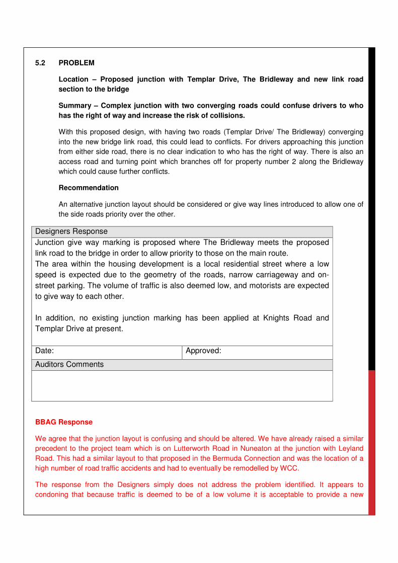
5.2 PROBLEM
Location – Proposed junction with Templar Drive, The Bridleway and new link road
section to the bridge
Summary – Complex junction with two converging roads could confuse drivers to who
has the right of way and increase the risk of collisions.
With this proposed design, with having two roads (Templar Drive/ The Bridleway) converging
into the new bridge link road, this could lead to conflicts. For drivers approaching this junction
from either side road, there is no clear indication to who has the right of way. There is also an
access road and turning point which branches off for property number 2 along the Bridleway
which could cause further conflicts.
Recommendation
An alternative junction layout should be considered or give way lines introduced to allow one of
the side roads priority over the other.
Designers Response
Junction give way marking is proposed where The Bridleway meets the proposed
link road to the bridge in order to allow priority to those on the main route.
The area within the housing development is a local residential street where a low
speed is expected due to the geometry of the roads, narrow carriageway and on-
street parking. The volume of traffic is also deemed low, and motorists are expected
to give way to each other.
In addition, no existing junction marking has been applied at Knights Road and
Templar Drive at present.
Date: Approved:
Auditors Comments
BBAG Response
We agree that the junction layout is confusing and should be altered. We have already raised a similar
precedent to the project team which is on Lutterworth Road in Nuneaton at the junction with Leyland
Road. This had a similar layout to that proposed in the Bermuda Connection and was the location of a
high number of road traffic accidents and had to eventually be remodelled by WCC.
The response from the Designers simply does not address the problem identified. It appears to
condoning that because traffic is deemed to be of a low volume it is acceptable to provide a new

junction that is confusing and could lead to accidents. It is also unacceptable to use the basis of the
current layout as justification for not having a give way line in the new layout when the addition of a
main road junction adds a lot of complexity and conflict to drivers. There is currently no main road
junction at Knights Road & Templar Drive (it’s a residential estate road) so the lack of any junction
markings is not wholly surprising but should not be used as the basis for not defining priorities at the
new junction.

5.3 PROBLEM
Location – Proposed junction with Templar Drive, The Bridleway and new link road
section to the bridge
Summary – Visibility restricted for persons pulling out of side road could lead to
collisions
At this location for persons pulling out from The Bridleway/ Templar Drive, visibility is restricted
to the right. This is due to the proposed curvature of the new bridge link road. Drivers will have
to look over their shoulder behind them to see approaching vehicles to the right. This could
result in them not seeing them and collisions occurring.
Recommendation
The junction should be relocated further away from the bend on the link road, such as Joining
the Bridleway near Knights Road. Alternatively the curvature of the link road should be modified
to improve visibility.
Designers Response
The close vicinity of the junction to the bridge and existing site constraints do not
allow the junction to be moved further to the east.
The proposed splitter island is nearly 7m, almost 1.5 times the length of an average
car. This should be sufficient to lead the motorists to arrive perpendicularly at the
give-way line. At this point, the junction visibility has been assessed which shows a
minimum of 90m visibility to the right. Refer to:
5131052-ATK-BCP-DR-120-03_A.
The layout will be re-assessed at the detailed design stage with a view to re-align the
south side kerb in The Bridleway to allow for a wider right turning movement.
Tracking analysis will also be carried out at this stage.
Date: Approved:
Auditors Comments
BBAG Response
What isn’t discussed is that the junction does not have adequate visibility to the east due to the vertical
curvature of the bridge with the junction not visible to drivers cover over the top of the bridge due to the
‘humped back’ nature of the bridge an approach ramps. The response does not acknowledge that
larger vehicles need access particularly rigid refuse trucks and delivery trucks.

It should be noted that the alignment has not been realigned as recommended. This leaves visibility
issues at the two tie in points of the new link road. You can see from BBAG/DWG/205/A that cars
parking in the service lane of the current section of The Bridleway will significantly obscure visibility to
the left. Therefore the 90m DMRB requirement is not meet by the proposed design. Simply realigning
the curve into the road at the detailed design stage will not solve the storage or visibility issues. The
visibility constraints to the east and west are such that the conclusion should be that it is unsafe to link
The Bridleway to Bermuda Bridge. The proposed design is below standards & could lead to significant
accidents, particularly with vehicles coming flying over the bridge from an industrial estate environment
straight into a residential area.

5.4 PROBLEM
Location –The Bridleway proposed access road leading to property No. 2
Summary – The turning head layout is spread out, meaning vehicles having to reverse
for a long distance, increasing the risk of collisions with vehicles turning into the side
road
For this proposed layout for vehicles travelling along this access, they are presented with a
dead end with no easy way to turn back around. Although there is an intended turning provision,
this is a long distance away, meaning vehicles will have to reverse back for some way, and
could be a difficult manoeuvre. If other vehicles happen to be turning into the access at the
same time, collisions could occur.
Recommendation
The road layout should be modified to allow for vehicles to be able to turn back around easily.
Designers Response
Agreed. The length of the proposed service road has now been reduced to ease the
turn back. Refer to:
5131052-ATK-BCP-DR-110-01_F.
Date: Approved:
Auditors Comments
BBAG Response
The above confirms that rather than address an issue & provide better turning provision for residents by
modifying the new link to provide a turning head at the end the solution is to just remove the provision
all together. These houses are mews properties that currently rely on on-street parking on The
Bridleway. This is another example of WCC putting cost before the needs of residents who are already
suffering terribly from the implementation of this new relief road.

5.5 PROBLEM
Location –The Bridleway junction with Bermuda Road (Bermuda Village)
Summary – Visibility restricted by foliage and trees for vehicles exiting Bermuda Road
could lead to collisions
With the new proposed layout there are plans to change the priority of this give way junction
from Bermuda Road to the Bridleway. Vehicles turning onto the Bridleway from Bermuda Way
could have restricted visibility due to existing foliage and trees. This could lead to collisions from
vehicles pulling out into oncoming traffic.
Recommendation
Foliage and trees should be trimmed back to increase visibility.
Designers Response
Agreed. This will be considered as part of the detailed design.
Date: Approved:
Auditors Comments
BBAG Response
The Design Manual for Roads & Bridges requires 90 metres of visibility is required (a standard
acknowledge by the Designers elsewhere in their response to the Road Safety Audit). Trees & shrubs
will grow back obscuring the visibility once more further reducing visibility below what is required. What
isn’t noted is that the visibility splay also goes through private land (see drawing BBAG/205/A). The
trees & shrubs that obscure visibility are within private land and are not necessarily overhanging the
highway maintainable at public expense. As the junction is on a desire line from Bermuda Village to the
Town Centre / hospital it is likely to be a crossing point for large number of pedestrians from Bermuda
Village rather than using the new pedestrian refuge which is some considerable distance away from the
desire line (the removal of the footway on the southern side of the bridge will add to the number of
people crossing at this location too).

5.6 PROBLEM
Location –Bermuda Road access to Harefield Lane shared cycleway
Summary – Proposed refuge crossing point and cycleway do not tie in with the existing
route, meaning cyclists my use the footpath and collide with pedestrians.
With proposals for a new crossing point and shared cycleway, this does not tie into the existing
one from Harefield Lane. Cyclists may emerge from this lane and use the crossing point to
access the new shared route on the opposite side of the road. To do this they are likely to cut
across the non-shared space footpath, where they may collide with pedestrians who may not be
expecting them to be using the footpath.
Recommendation
The footpath on the south side of the refuge should be changed to shared space to join up the
existing cycle route.
Designers Response
Agreed. This will be considered as part of the detailed design.
Date: Approved:
Auditors Comments
BBAG Response
This confirms that WCC brought a scheme with known safety issues to the public consultation. If the
scheme proceeds to detailed design there is no redress for the community if they fail to re-assess this
at the detail design stage & go ahead with the current design. This is yet another example of WCC
putting cost before the needs of residents.
However the issue cannot be satisfactorily resolved. The minimum desirable width according to WCC’s
own standard details is 4m. The current footway is 2.3m wide which is well below this and the minimum
acceptable width for a shared footway (Local Transport Note 2/08, Cycle Infrastructure). The current
design and provision for non-motorised road users is simply inadequate.

5.7 PROBLEM
Location –Bermuda Road opposite Hazell Way
Summary – Termination point for cycle route leads cyclist into road at junction and onto
wrong side of the road (if heading north) which could lead to collisions.
For cyclists travelling north, the cycle route terminates at a point opposite Hazell Way. They will
also be on the wrong side of the road, where they must cut over to the other side. At this point
with vehicles turning out of the side road, they may not see the cyclists merging back onto the
carriageway and collide with them. There could also be the issue of cyclists having to cut across
traffic flow to allow them back onto the left hand lane of the carriageway.
Recommendation
The merge point should be located away from any side road junctions. There should also be a
crossing point to allow them safe access the left hand lane of the carriageway.
Designers Response
Agreed. The proposed shared route has now been extended to link in to the footpath
leading to Ensors Pool. A refuge has also been provided to allow for a safe crossing
point. Refer to:
5131052-ATK-BCP-DR-125-01_D
Date: Approved:
Auditors Comments
BBAG Response
Despite the change noted above the crossing point is still not the ideal arrangement particularly as it is
uncontrolled crossing. There is no warning to motorists of cyclists entering the carriageway. Bringing
cyclists back onto the carriageway at an acute angle with the refuge narrowing down the road width
between the kerb and refuge to only 3m (not wide enough for a motorise vehicle to safely pass a
cyclist) could be dangerous and lead to accidents from the confusion / surprise. The cycling provision
provided as part of the Bermuda Connection is unsuitable compared to the existing conditions.

5.8 PROBLEM
Location –Bermuda Road junction with Tenlons Road
Summary – Close Proximity of mini roundabout with junction of Heath End Road could
result in queues backing up on to it. This could result in shunt collisions with vehicles on
the main road
With the proposed mini roundabout for Tenlons Road, this will give priority for potentially large
vehicles to pull out onto Bermuda Road. Given its close proximity to the Heath End Road
junction, vehicles turning into Bermuda Road may have to wait and queue while a large vehicle
is making this manoeuvre. This could cause the traffic to stack up into Heath End Road. With a
green light situation approaching vehicles may not be expecting stationary traffic and slow down
sufficiently, resulting in a shunt type collision.
Recommendation
The mini roundabout should be replaced with a give way junction and ‘Keep clear’ markings.
Ensuring traffic on Bermuda way is given the priority and doesn’t queue back up into the
signalised junction.
Designers Response
The mini-roundabout has been proposed to provide a balanced priority to those
motorists using Tenlons Road to access Bermuda Road in order to avoid the Heath
Road End / Bermuda Road junction. This route will be signed as not suitable for
bypassing HGVs (see drawing 5131052-ATK-BCP-DR-130-02_F).
With this, only a limited number of the HGVs accessing the properties on Tenlons
road are expected to carry out such a manoeuvre. The risk is therefore deemed to
be low.
In addition, the junction modelling has demonstrated that queues on the Bermuda
Road arm on the proposed Heath End road junction are not likely to extend back into
the mini-roundabout, and queues on the mini-roundabout are not likely to extend
back into the Heath End Road junction.
Date: Approved:
Auditors Comments
BBAG Response
No housing or future traffic growth has been modelled by WCC meaning that the junction will be
saturated immediately upon opening. HGV’s also regularly access Tenlons Road to access the various
businesses in the industrial area and we agree that Tenlons Road is unsuitable for HGV access,
however, Bermuda Road is equally unsuitable. At the moment HGVs have to mount footways to access

these streets or swing completely into the wrong side of the road something that will still be essential
under the proposed designs. This is proved by Atkins own swept path drawings which show numerous
clashes between passing vehicles, adjacent lanes and overhanding of the footway even at pedestrian
crossing points of both of the above named junctions. We also agree that queues are likely to extend
back and block the junction. There are errors that have been highlighted to WCC within the traffic
modelling which will reduce the capacity of the junction and result in longer queues than the current
modelling suggests.
According to the DfT’s Mini-Roundabouts Good Practice Guidance “Mini-roundabouts may be
introduced at junctions that experience problems with safety or side road delay”. There junction of
Tenlons Road and Bermuda Road currently has no recorded personal injury accidents (checked
November 2015 on crashmap.co.uk) and suffers from no delays. With the mini-roundabout installed in
isolation there is a significant concern that vehicles will ride over the mini roundabout without giving way
to traffic from the right resulting in road traffic accidents at a junction which currently has no accidents.
It can be seen on BBAG drawing BBAG/DWG/201 that residential gardens, walls and hedgerows mean
that the required visibility of DMRB (TD 54/07 Design of Mini-Roundabouts clause 6.17 is not
achieved). Of more concern is that visibility isn’t even achieved to the uncontrolled pedestrian crossing
with visibility down to a few metres of vehicles turning right from Bermuda Road into Tenlons Road and
limited visibility of small children for those turning left into Tenlons Road from Bermuda Road. This
crossing is on the main walking route from Bermuda Road to Glendale, Croft and Middlemarch Schools
plus the Nuneaton Academy.
Both the speed and path of a vehicle through a mini-roundabout are important factors in accident
causation. The layout should be designed so that the approaching drivers are aware of the circulatory
nature of the junction ahead. Drivers need to be ready to stop if necessary on the approach so it is
essential for entry (and circulatory) speed to be managed by careful design. However, there is nothing
in the Bermuda Connection design to slow down drivers, in fact the very opposite is true through the
prohibition of on-street parking. A lateral shift to create deflection has been provided to the mini
roundabout but the junction is too constrained and this results in a positioning to the central island in a
location that even a car will not circulate around the island. Cars are encouraged to take a line around
the wrong side of the island. There are a number of driveways that emerge into the middle of the mini
roundabout and it will be very confusing for drivers to be able to stop in the middle of the roundabout
and then reverse onto their drive. A mini roundabout cannot be considered a good traffic management
feature when used in isolation with the location just too constrained to meet all the requirements of a
safe mini-roundabout design and is likely to lead to people being killed or serious injured.
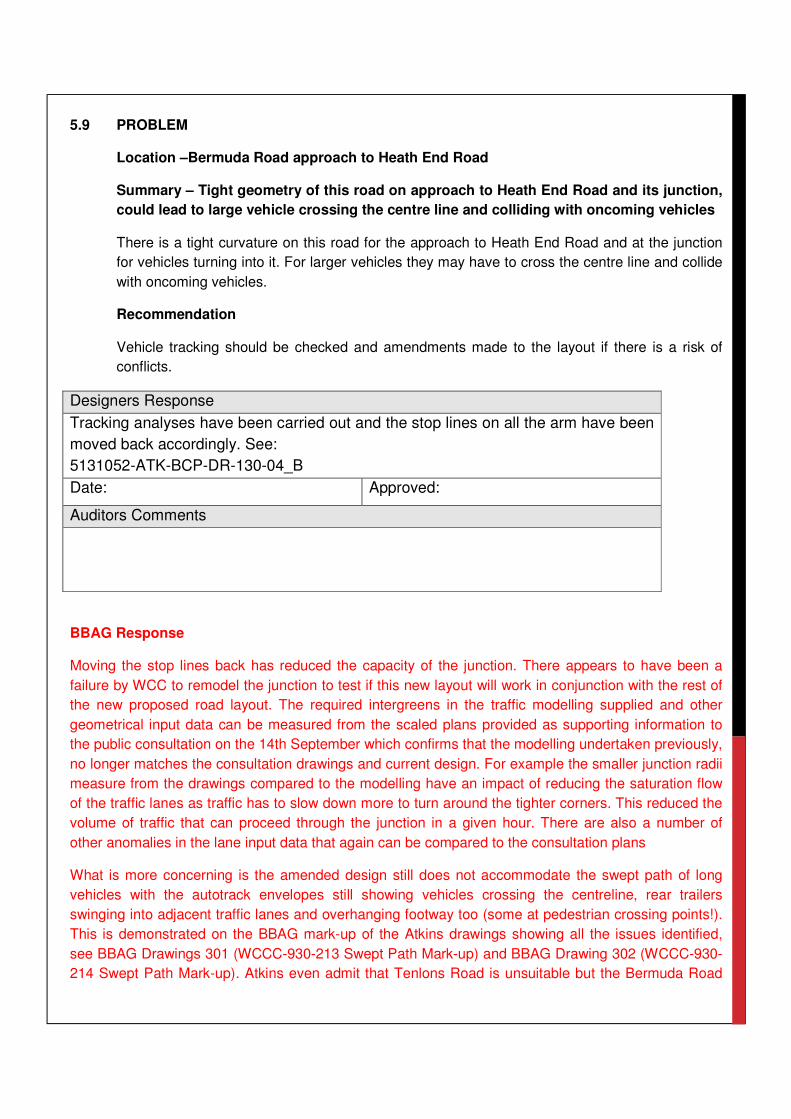
5.9 PROBLEM
Location –Bermuda Road approach to Heath End Road
Summary – Tight geometry of this road on approach to Heath End Road and its junction,
could lead to large vehicle crossing the centre line and colliding with oncoming vehicles
There is a tight curvature on this road for the approach to Heath End Road and at the junction
for vehicles turning into it. For larger vehicles they may have to cross the centre line and collide
with oncoming vehicles.
Recommendation
Vehicle tracking should be checked and amendments made to the layout if there is a risk of
conflicts.
Designers Response
Tracking analyses have been carried out and the stop lines on all the arm have been
moved back accordingly. See:
5131052-ATK-BCP-DR-130-04_B
Date: Approved:
Auditors Comments
BBAG Response
Moving the stop lines back has reduced the capacity of the junction. There appears to have been a
failure by WCC to remodel the junction to test if this new layout will work in conjunction with the rest of
the new proposed road layout. The required intergreens in the traffic modelling supplied and other
geometrical input data can be measured from the scaled plans provided as supporting information to
the public consultation on the 14th September which confirms that the modelling undertaken previously,
no longer matches the consultation drawings and current design. For example the smaller junction radii
measure from the drawings compared to the modelling have an impact of reducing the saturation flow
of the traffic lanes as traffic has to slow down more to turn around the tighter corners. This reduced the
volume of traffic that can proceed through the junction in a given hour. There are also a number of
other anomalies in the lane input data that again can be compared to the consultation plans
What is more concerning is the amended design still does not accommodate the swept path of long
vehicles with the autotrack envelopes still showing vehicles crossing the centreline, rear trailers
swinging into adjacent traffic lanes and overhanging footway too (some at pedestrian crossing points!).
This is demonstrated on the BBAG mark-up of the Atkins drawings showing all the issues identified,
see BBAG Drawings 301 (WCCC-930-213 Swept Path Mark-up) and BBAG Drawing 302 (WCCC-930-
214 Swept Path Mark-up). Atkins even admit that Tenlons Road is unsuitable but the Bermuda Road

access has similar issues with swept paths clashing and vehicles overhanging footway which risks
pedestrians or street furniture being hit.

5.10 PROBLEM
Location –Heath End Road junction with Bermuda Road and junction with The Raywoods
Summary – Low storage capacity for queuing vehicles, given very close proximity
between the two signalised junctions could lead to shunt type accidents.
With a new signalised junction to be installed for Bermuda Road / Heath End Road this is in
very close proximity to an existing signalised junction for The Raywoods. As a result there is
very little storage capacity (approximately two/ three vehicles) to queue between the two
junctions, including the right hand turn lanes and this could easily get gridlocked. With a green
light situation, approaching vehicles may not be expecting stationary traffic and slow down
sufficiently, resulting in shunt type collisions.
Recommendation
The two signalised junctions should be synchronised to minimise queuing between them or a
new layout should be considered.
Designers Response
Agreed. The two proposed signalised junctions have been synchronised and the
traffic modelling suggests that there would be no queuing issues at these junctions.
Additional measures should be included in the controller specifications / MOVA
datasets at the detailed design stage to ensure that this synchronisation will occur.
Date: Approved:
Auditors Comments
BBAG Response
The auditors have pointed out that the new proposed traffic light junction at Heath End Road/Bermuda
Road/The Raywoods will not work as the right hand turn lane could get ‘easily gridlocked’. The traffic
modelling errors and omissions noted earlier within this response also need to be considered in that the
capacity of the junction is lower than that modelled by WCC and the that the traffic flows are likely to be
much higher due to traffic growth and cumulative development (new housing that is reliant on this link
road). WCC have not been able to provide any evidence that the new signalised junctions cannot
accommodate the future year traffic flows or the committed development. The geometry of the junction
in the consultation plans does not match that in the traffic modelling undertaken for the scheme. It is
likely that the junction will become gridlocked based on a review of the evidence presented by WCC
and the significant sums required for the Bermuda Connection should not be invested in a scheme that
does not solve the traffic problems along Heath End Road

It can be seen from the proposed layouts that the right turn lanes can only accommodate two right
turning vehicles. The HGV swept paths show that a single HGV cannot safely enter these lanes without
encroaching on other lanes and the lane is of insufficient length to store such a vehicle. All of the above
issues can be seen on drawings BBAG/DWG/301/A based upon the revised Atkins design.
In addition to the above issues the junctions have a mix of controlled an uncontrolled crossings. There
are also driveways emerging into the middle of new signal controlled junctions. The proposed junction
is not complaint with DMRB (TD 50/04 The Geometric Layout of Signal Controlled Junctions &
Signalised Roundabouts). This junction is unsafe for motorists, pedestrians & residents and will have
capacity issues from the outset.

5.11 PROBLEM
Location –Hare and Hounds public house car park
Summary – Vehicles potentially cutting across full height kerb to take short cut to access
junction, with the risk of vehicles turning at the junction colliding with them.
Although it has been stated on the drawing that a full height kerb will be installed for the public
house car park. There is no indication of an alternative route for patrons to exit the car park.
Drivers may still decide to take a short cut regardless of the full height kerb onto Heath End
Road junction. At this location other vehicles may be turning and collide with the vehicle exiting
the car park, who will be unaware of the status of the signals.
Recommendation
Bollards or railing should be installed to stop persons accessing Heath End Road from the pub
car park and alternative route onto Hare and Hound Lane should be sought.
Designers Response
Agreed. It is proposed that the main entry/exit will be via Hare and Hounds Lane as
marked on drawing 5131052-ATK-BCP-DR-130-01_E
The capital cost estimates at this preliminary stage take account of a low height wall
(similar to existing between the pub car park and Hare and hounds Lane) along the
south side of the car park preventing direct access to/from Heath End Road. This
hasn’t been specifically mentioned on the preliminary design drawing but will be
included on detailed design drawings.
Date: Approved:
Auditors Comments
BBAG Response
Hare & Hounds lane is a small single track road that cannot accommodate a lot of traffic, with poor
visibility from Heath End Road. The car park at the pub is heavily used. Moving the entrance to the pub
car park will lead to issues on Hare & Hounds Lane with possible collisions between vehicles turning
into Hare & Hounds pub and vehicles using Hare & Hounds Lane masked by a blind corner created by
the pub building itself. Also moving the pub car park entrance will result in a very tight turn to exit which
will require the driver to drive on the wrong side of the carriageway. There is also a significant height
difference between Hare & Hounds Lane & the pub car park with the car park being level & steps at the
far end descending to the pub entrance. In addition to this the loss of land from the car park for
realigning the road and could ultimately make the public house an unviable business if patrons cannot
find sufficient parking.

The pub car park is not the only issue at this junction as there are private driveways and an industrial
complex of small business units adjacent to the pub car park which rely on regular heavy goods vehicle
deliveries (one of the businesses deals with construction supplies). These accesses would emerge
without control into the middle of a controlled signalised junction. The current signalisation plans do not
provide a safe design for all road users.
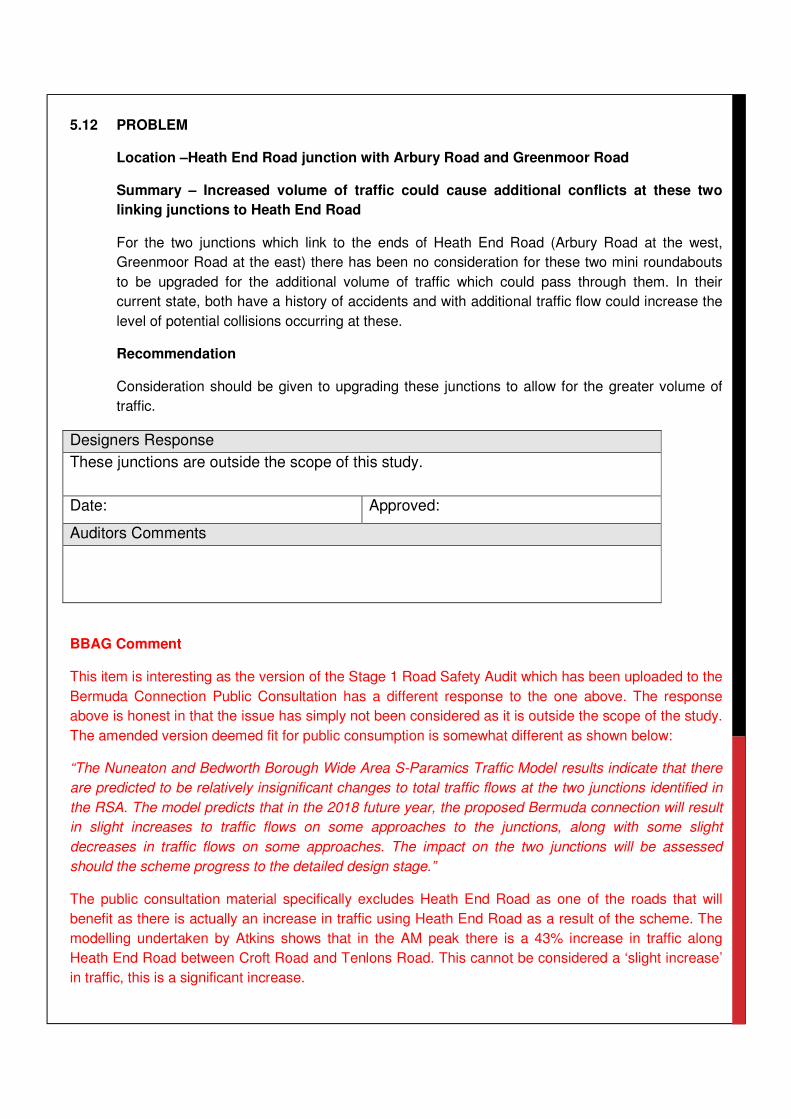
5.12 PROBLEM
Location –Heath End Road junction with Arbury Road and Greenmoor Road
Summary – Increased volume of traffic could cause additional conflicts at these two
linking junctions to Heath End Road
For the two junctions which link to the ends of Heath End Road (Arbury Road at the west,
Greenmoor Road at the east) there has been no consideration for these two mini roundabouts
to be upgraded for the additional volume of traffic which could pass through them. In their
current state, both have a history of accidents and with additional traffic flow could increase the
level of potential collisions occurring at these.
Recommendation
Consideration should be given to upgrading these junctions to allow for the greater volume of
traffic.
Designers Response
These junctions are outside the scope of this study.
Date: Approved:
Auditors Comments
BBAG Comment
This item is interesting as the version of the Stage 1 Road Safety Audit which has been uploaded to the
Bermuda Connection Public Consultation has a different response to the one above. The response
above is honest in that the issue has simply not been considered as it is outside the scope of the study.
The amended version deemed fit for public consumption is somewhat different as shown below:
“The Nuneaton and Bedworth Borough Wide Area S-Paramics Traffic Model results indicate that there
are predicted to be relatively insignificant changes to total traffic flows at the two junctions identified in
the RSA. The model predicts that in the 2018 future year, the proposed Bermuda connection will result
in slight increases to traffic flows on some approaches to the junctions, along with some slight
decreases in traffic flows on some approaches. The impact on the two junctions will be assessed
should the scheme progress to the detailed design stage.”
The public consultation material specifically excludes Heath End Road as one of the roads that will
benefit as there is actually an increase in traffic using Heath End Road as a result of the scheme. The
modelling undertaken by Atkins shows that in the AM peak there is a 43% increase in traffic along
Heath End Road between Croft Road and Tenlons Road. This cannot be considered a ‘slight increase’
in traffic, this is a significant increase.

The scheme does result in a significant increase in traffic particularly at the Croft Road junction. The
costs of upgrading these junctions needs to be factored into the Bermuda Connection Scheme as it will
reduce the business case for undertaking the project. Reducing flows on one arm will increasing them
on another can have a profound effect on the operation of a 3 arm mini roundabout. Considering these
junctions separately could result in the creation a safety issue that remains unresolved as there is no
budget to mitigate the impacts of the project. The upgrade to these junctions should be being
considered now at the public consultation stage.

6.0 GENERAL COMMENTS
6.1 COMMENT
Location –Bermuda Road/ The Bridleway whole extents of route
Summary – Double yellow lines across the entire route could increase vehicle speeds
and increase the chance of collisions occurring.
There was evidence of numerous parked vehicles along this route which acted as a natural
traffic calming feature. With parking restrictions put in place, this could increase vehicle speeds
along the route and increase the risk of speed related collisions occurring. There is also the
possibility that residents may park down the side roads and near the mouths of the many
junctions along Bermuda Road without any other provision to park.
Recommendation
Traffic calming / speed reducing measures should be installed along the route and consideration
to additional residents parking considered.
Designers Response
Comment noted. Traffic calming / speed reduction measures will be considered as
part of the detailed design and in conjunction with the client’s requirements.
Date: Approved:
Auditors Comments
BBAG Comment
This is a very important point to make and it is clear that the auditors are confirming it should be
installed along the whole of the route (within residential areas) if the project proceeds. What are the
Client Requirements that are preventing the implementation of this clear recommendation? This change
should have been made to the Public Consultation plans and is a mitigation the local community has
always insisted on if the scheme is forced through against the wishes of the public (see public
consultation results which give a big ‘thunbs down’ to the project)

None of the option / mitigations included within the cabinet report include this mitigation and hence no
cost to deliver this element. The above is confirmation that WCC are fully aware that this scheme
should be implementing traffic calming. Rather than alleviating traffic issues in the wider area, the
scheme is actually going to create more & will increase vehicle speed and significantly increase the
likelihood and severity of road traffic accidents. A JMP study into the project noted:
“Construction of the development, as well as opening it to the traffic will produce air and noise pollution
and increase roads accidents and congestion around the site. The development will also affect
residents of Nuneaton due to increase of pollutants related to traffic emission”
It is simply unacceptable for WCC to be recommending the scheme progresses to detailed design with
no funding or option to provide traffic calming when this is arguably the single biggest safety issues
raised with the audit.

7.0 AUDIT TEAM STATEMENT
7.1 We certify that we have examined the drawings and documents listed in Section 3.0 of this
report. The examination has been carried out with the sole purpose of identifying any features
that could be removed or modified that would improve the safety of the scheme. The problems
identified have been notified in this report together with a recommendation, which should be
studied for implementation. No one on the Audit Team Membership was linked to the scheme
design.
AUDIT TEAM LEADER
Name: Lee Williams BSc (Hons) Signed:
Position: Senior Engineer Date: 12/06/2015
Organisation: Warwickshire County Council
Address: Communities, PO Box 43, Warwick, CV34 4SX
AUDIT TEAM MEMBER
Name: Jo Edwards (Mrs) MIHE Eng Tech Signed:
Position: Principal Engineer Date: 12/06/2015
Organisation: Warwickshire County Council
Address: Communities, PO Box 43, Warwick, CV34 4SX


![Registrar’S office23.5 F, Fa, Fe U 23.1 23.2 23.3 24 Audit 24.1 Audit Audit 23.1 Audit 24.3 Audit Audit Audit Aud. 24.6 Audit 80 Audit 80 25 25.1 C 80 25.2 26 26.1 3.5 îlLt_Jðth]](https://img.pdfslide.us/doc/110x75/60922293f5299d6df61fd513/registraras-office-235-f-fa-fe-u-231-232-233-24-audit-241-audit-audit-231.jpg)